

Introduction
The Chiquibul Forest Reserve and National Park (CFRNP) in Belize is a priority conservation area within the ‘Maya Forest’ in Central America. The Maya Forest is the largest continuous tropical rain forest in Central America, a region that holds around 8% of the world’s described vascular plant species, of which over 20% are endemic to the region (Myers et al., Reference Myers, Mittermeier, Mittermeier, Da Fonseca and Kent2000; Bridgewater et al., Reference Bridgewater, Harris, Whitefoord, Monro, Penn, Sutton, Sayer, Adams, Balick, Atha, Solomon and Holst2006a). Due to its high biodiversity value and its high level of threat, it is the second most important of the 25 global hotspots (Conservation International, 2004). Located to the east of the Rio Chiquibul-Montañas Maya Biosphere Reserve in the Guatemalan Petén ecoregion, the CFRNP is situated within one of eight key conservation areas in the northern Mesoamerican ecosystem profile of the Critical Ecosystem Partnership Fund and forms part of the Mayan Forest corridor (Conservation International, 2004). At over 1744 km2, the Chiquibul region comprises part of Belize’s largest remaining forest, much of which occurs on karstic limestone terrain. Due to its remoteness, the eastern part of the Chiquibul remains botanically little explored (Bridgewater et al., Reference Bridgewater, Harris, Whitefoord, Monro, Penn, Sutton, Sayer, Adams, Balick, Atha, Solomon and Holst2006a).
Karst is globally rare, but roughly half of the Caribbean and 25% of Central American landscapes are karstic, including the Greater Antilles, the Yucatan Peninsula and the Guatemalan Petén region (Kueny & Day, Reference Kueny and Day1998, Reference Kueny and Day2002). Belize, in particular the Chiquibul Forest, harbours significant areas of limestone forest. Studies of tropical forests over limestone are rare due to its restricted distribution, but also because the steep terrains are difficult to access (Kelly et al., Reference Kelly, Tanner, Kapos, Dickinson, Goodfriend and Fairbairn1988).
The Chiquibul region is of high biological importance, providing key habitat for endangered and locally threatened species of vertebrates, including tapir (Tapirus bairdii), jaguar (Panthera onca), ocelot (Leopardus pardalis), spider monkey (Ateles geoffroyi) and the Central American scarlet macaw (Ara macao cyanoptera). While a provisional checklist of the vascular plants exists, this list is biased towards easily accessible sites (e.g. Guacamallo Bridge, Las Cuevas Research Station). Bridgewater et al. (Reference Bridgewater, Harris, Whitefoord, Monro, Penn, Sutton, Sayer, Adams, Balick, Atha, Solomon and Holst2006a) show that of the total 7047 herbarium specimens known from the Chiquibul Forest, both the Upper and Lower Raspaculo area were extremely poorly represented, with only <50 and <200 collections, respectively. Several expeditions have been carried out in the area (Rogers & Sutton, Reference Rogers and Sutton1991; Rogers et al., Reference Rogers, Sutton and Stafford1994; Rogers, Reference Rogers2001) but, to our knowledge, no herbarium specimens were collected. Since most conservation prioritisation at global and local levels is based on species distributions and species threat status assessments (Myers et al., Reference Myers, Mittermeier, Mittermeier, Da Fonseca and Kent2000; Grenyer et al., Reference Grenyer, Orme, Jackson, Thomas, Davies, Davies, Jones, Olson, Ridgely, Rasmussen, Ding, Bennett, Blackburn, Gaston, Gittleman and Owens2006; Joppa et al., Reference Joppa, Visconti, Jenkins and Pimm2013), systematic collections are essential for local and site-specific biodiversity management. Complete species lists allow conservation managers to identify potentially restricted species distributions and compare and contrast forest types, ultimately establishing local biodiversity ‘hotspots’ of particular conservation concern (Kim & Byrne, Reference Kim and Byrne2006; Meerman, Reference Meerman2007). During recent decades, however, traditional taxonomy has been severely neglected (Boero, Reference Boero2010) and the lack of site-specific knowledge is hampering applied conservation efforts.
The CFRNP consists of the Chiquibul Forest Reserve (CFR, 59,822 ha), the Chiquibul National Park (CNP, 106,838 ha), and the Caracol Archaeological Reserve (10,339 ha) (Conservation International, 2010; Friends for Conservation and Development, 2011). The CFR and CNP together comprise lowland to submontane broadleaved forest types ranging from semi-deciduous to evergreen, as well as riverine vegetation along the Macal and Raspaculo Rivers. The latter are important wildlife refuges, particularly during the dry season (Minty et al., Reference Minty, Sutton, Rogers, Bateman, Penn, Stafford and Sanders2001).
The area occupied by riverine habitat in Belize is declining as a result of the construction of a series of hydroelectric dams (Chalillo, Mollejon and Vaca) on the Macal River. Much of the riverine forest in the Macal and Raspaculo watersheds was lost following the filling of the Chalillo Dam in 2006. The Raspaculo River is a large tributary to the Macal, and its lower reaches have now become part of the Chalillo reservoir. The riverine forest of the Upper Raspaculo region of the CNP thus comprises some of the last vestiges of this once more widely distributed vegetation type. Together, the Macal and Raspaculo watersheds hold 60% of Belize’s broadleaved lowland riverine habitat, mostly on karstic but also on metamorphic rock (Minty et al., Reference Minty, Sutton, Rogers, Bateman, Penn, Stafford and Sanders2001). However, the increased accessibility created by the Chalillo reservoir now also newly exposes the remaining habitat to regional threats such as deforestation, poaching, Xaté extraction and expansion of agriculture including cattle ranching (Conservation International, 2004; Bridgewater et al., Reference Bridgewater, Pickles, Garwood, Penn, Bateman, Porter Morgan, Wicks and Bol2006b; Young, Reference Young2008; Briggs et al., Reference Briggs, Mazzotti, Harvey, Barnes, Manzanero, Meerman, Walker and Walker2013).
Although there is a broad vegetation classification of Belize based on satellite data (Penn et al., Reference Penn, Sutton and Monro2004), little is known about plant community composition within particular forest types. This is especially the case for the Upper Raspaculo region and the dry hilltop vegetation across the Chiquibul. Brewer et al. (Reference Brewer, Rejmánek, Webb and Fine2003) studied limestone vegetation across an elevation gradient, showing interesting phytosociological patterns and details of composition. Only a few studies of the Chiquibul Forest exist (Bird, Reference Bird1998; Urban et al., Reference Urban, Bridgewater and Harris2006; Cho et al., Reference Cho, Blackburn, Bird, Brewer and Barlow2013). Cho et al. (Reference Cho, Blackburn, Bird, Brewer and Barlow2013) focused on disturbed areas of the Western Chiquibul lowland forest based on data from Bird (Reference Bird1998), while Urban et al. (Reference Urban, Bridgewater and Harris2006) studied phytosociology of seasonally inundated riverine vegetation. Quantitative vegetation studies are now needed to improve our understanding of the vegetation types within the Chiquibul Reserve across the elevation gradient within the context of Belize and the wider Petén region that hosts vast areas of tropical limestone broadleaved forest.
Here we present a floristic study of the eastern part of the Chiquibul Forest Reserve and National Park, focusing on the least collected areas identified in Bridgewater et al. (Reference Bridgewater, Harris, Whitefoord, Monro, Penn, Sutton, Sayer, Adams, Balick, Atha, Solomon and Holst2006a). Our study aims to improve taxonomic documentation of the local biodiversity specifically in the Upper and Lower Raspaculo, and at Natural Arch, which lies further south. A comparison is made between 0.1 hectare datasets across elevation zones sampling trees, shrubs, palms and lianas. Additionally, we present data for one 1 ha plot from Upper Raspaculo. The results show clear differences between hilltop and valley floor vegetation communities, and include new species records for the area.
Study Site
The climate of Belize has a pronounced dry season (Dubbin et al., Reference Dubbin, Penn and Hodson2006) and an average annual temperature of 26°C. The onset of the seasons is controlled by the position of the Intertropical Convergence Zone (ITCZ) which brings increased precipitation between late May and December (Gischler et al., Reference Gischler, Shinn, Oschmann, Fiebig and Buster2008; Bhattacharyaa et al., Reference Bhattacharyaa, Beacha and Wahl2011). Rainfall is particularly variable in the Maya mountains where precipitation decreases towards the northwestern flanks, with c.1000–2500 mm annual rainfall in the CFRNP (Pérez et al., Reference Pérez, Bugja, Lorenschat, Brenner, Curtis, Hoelzmann, Islebe, Scharf and Schwalb2011).
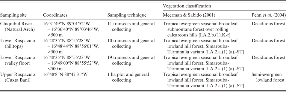
Three major locations within CFRNP were sampled during this study with particular focus on the Raspaculo watershed in the east: (1) Natural Arch; (2) Lower Raspaculo; (3) Upper Raspaculo at Cuxta Bani (Fig. 1, Table 2). The Raspaculo River runs through the CNP from east to west before turning north and flowing into the Macal River. The watershed encompasses c.150 km2 of mainly karstic limestone terrain with metamorphic substrates present at the upper reaches (Bateson & Hall, Reference Bateson and Hall1977). Water levels in the Raspaculo River fluctuate dramatically during the year depending on rainfall. The Lower Raspaculo was accessed from Chalillo Dam by canoe and flat-bottomed boat. Study sites in the Lower Raspaculo were reached by canoes and on foot, and Cuxta Bani was reached by canoe.
Location of study sites in Belize. (A) Location of Belize within Central America. (B) The Greater Maya Mountains in southern Belize with three major collecting localities of the study. (C) Detailed location of study sites within the Raspaculo watershed (Landsat Enhanced Thematic Mapper image, 18 February 2002, pixel resolution 30 m, Global Land Cover Facility, www.landcover.org). (D) Overview of all collection localities in relation to the Belize Protected Areas from BERDS (Meerman & Clabaugh, Reference Meerman and Clabaugh2015).

The different study sites (Table 2) mapped into two of Meerman & Sabido’s (Reference Meerman and Sabido2001) broadleaved vegetation types, including the ‘Tropical evergreen seasonal broadleaved lowland hill forest, Simarouba-Terminalia variant’ [UNESCO classification code I.A.2.a.(1).(a).-ST] in the Lower Raspaculo and Cuxta Bani in the Upper Raspaculo. Natural Arch was classed as ‘Tropical evergreen seasonal broadleaved submontane forest over rolling calcareous hills’ [I.A.2.b.(1).K-r]. Penn et al. (Reference Penn, Sutton and Monro2004) map all Lower Raspaculo and most Natural Arch transects as ‘Deciduous forest’ but distinguish Cuxta Bani as ‘Semi-evergreen lowland forest’ (Table 2). The substrate at the Lower Raspaculo is karstic with sedimentary deposits along the river channel whilst karstic limestone is absent from Cuxta Bani in the Upper Raspaculo where substrates are metamorphic and sedimentary (Bateson & Hall, Reference Bateson and Hall1977).
Methods
Floristic surveys across the study sites were done along 0.1 ha transects, on one 1 ha plot, and by general collecting (Fig. 1, Table 2). Woody vegetation was studied along transects in Natural Arch and Lower Raspaculo, while the 1 ha plot was established in Cuxta Bani. General collecting was done around Natural Arch on the Chiquibul River during May and around Lower Raspaculo in June and July, where additional fertile material, mainly of woody taxa, was collected along paths and around camp. The aim was to supplement infertile material from the transects so that more taxa could be determined; herbs and epiphytes were mostly ignored.
Quantitative 0.1 ha vegetation transects were done following the methodology of Gentry (Gentry, Reference Gentry, Hecht, Wallace and Prance1982b; Phillips & Miller, Reference Phillips and Miller2002) in which all individuals ≥2.5 cm DBH (diameter at breast height, i.e. 130 cm) within 10 lines of 2 × 50 m area were recorded. A total of forty 2 × 50 m transects were assessed across the study sites, totalling 0.4 ha. Eleven transects were placed near Natural Arch within an elevational range of 500–600 m, and the remaining 29 in the Lower Raspaculo. Of the 29 transects in the Lower Raspaculo, 11 were placed on hilltops at 550–610 m elevation and 10 close to rivers on valley floors at c.410–470 m elevation in order to compare floristic composition in the visually distinct vegetation types along the elevational gradient in the karstic terrain. A further eight transects were placed in valley floors in areas with differing reflectance values as revealed by LANDSAT ETM 4-5-7 (RGB) satellite imagery. Species abundance data within equal areas of 0.1 ha were then compared between the Lower Raspaculo hilltops and the valley floors in terms of stem density, species importance value (Mori et al., Reference Mori, Boom, Carvalho and Santos1983) and species composition. At Natural Arch, only two size classes were recorded: above and below 10 cm DBH. All other transects recorded exact diameter measurements.
The 1 ha plot was established according to RAINFOR methodology (Phillips & Baker, Reference Phillips and Baker2002). All woody stems of ≥10 cm DBH were recorded, including lianas. Due to lack of tree climbing equipment, 15% of the stems remained unvouchered. The plot data were used to measure the total stem basal area (BA), relative abundance, frequency, dominance, and the resulting importance value (IV) of all taxa following the methodology of Mori et al. (Reference Mori, Boom, Carvalho and Santos1983). Sterile vouchers of all species were collected in all vegetation transects and the 1 ha plot, including unidentified ‘morphospecies’. Fertile specimens were collected with six duplicates, while non-fertile material was vouchered with two duplicates only. Duplicates of all vouchers have been deposited at Belmopan Forestry Department herbarium (BRH) and the Royal Botanic Garden Edinburgh (E). Further duplicates of specific families, where available, have been sent to BM (Solanaceae), MO (Rubiaceae), K (Leguminosae) and HBG (Lauraceae). Wood collections of lianas were made to aid species identification using stem anatomical characters, and are deposited at E.
Some of the determinations of voucher material by family experts include cf. qualifiers, given in the text and in Table 1. In cases where specimens both with cf. qualifier and without were identified, the cf. identifications are not listed in Table 1. ‘Cf. cases’ are treated as valid identifications that nonetheless do not hold the same level of confidence as those without the cf. qualifier. We refrain from downgrading these cf. determinations to generic rank, as the cf. determinations were given by experts in their group.
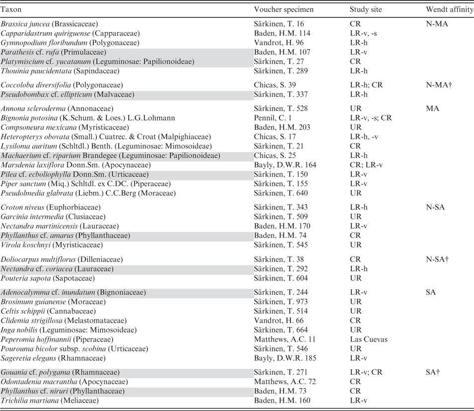
Species checklist resulting from collections (n = 1359) across all study sites. See table footnotes for details
– All species listed here, and/or in the text, have at least one voucher specimen, with the exceptions of Ceiba pentandra, Pimenta dioica, Pleradenophora tuerckheimiana and Arecaceae – these are listed from observation only. If a group of specimens were identified, some with and some without a cf. qualifier, then the taxon without the cf. has been listed in this species checklist as the voucher for this taxon. If recorded species were identified only with the cf. qualifier, these have been listed as such in the table, and quoted as such in the text throughout.
– Taxa identified to genus level only are not included in the species list, as their inclusion here would not contribute much of value for the overall species list, but they are nonetheless discussed in the text as plant records albeit insufficiently identified.
– List indicates habit (h = herb, s = shrub, t = tree, l = liana, e = epiphyte, he = hemiepiphyte, p = parasite, pa = palm), voucher, collection localities (LR = Lower Raspaculo, -h = hilltop, -v = valley, -s = slope, -p = palm-dominated area, UR = Upper Raspaculo, CR = Chiquibul River at Natural Arch), and floristic affinity after Wendt (Reference Wendt, Ramamoorthy, Bye, Lot and Fa1993) (N-MA = Northern Mesoamerica, MA = Mesoamerica, N-SA = Northern South America, SA = South America, † = Greater Antilles).
– Species records new to the Chiquibul vascular plant checklist by Bridgewater et al. (Reference Bridgewater, Harris, Whitefoord, Monro, Penn, Sutton, Sayer, Adams, Balick, Atha, Solomon and Holst2006a) are highlighted in grey and bold, taxa that would be new if their ‘cf.’ identification were to be confirmed are highlighted in grey only (not bold), and species records new to the checklist of Belize (Balick et al., Reference Balick, Nee and Atha2000) are highlighted in grey, bold and marked with *.
The authorities of species names follow Brummitt & Powell (Reference Brummitt and Powell1992) and are given in the text upon first mention and provided in Table 1. All species names were checked in TROPICOS, and new records were also checked in Flora Mesoamericana (2014). The species list was matched with the Catalogue of Life (CoL; Roskov et al., Reference Roskov, Kunze, Orrell, Abucay, Paglinawan, Culham, Bailly, Kirk, Bourgoin, Baillargeon, Decock, De Wever and Didžiulis2014), and IUCN Red List status of each species was retrieved from the IUCN Red List official website, using the R package Taxize (Chamberlain & Szocs, Reference Chamberlain and Szocs2013; Chamberlain et al., Reference Chamberlain, Szocs, Boettiger, Ram, Bartomeus and Baumgartner2014). The TROPICOS database was checked for further publications on species status assessments. Table 1 lists all species determined below genus rank, and functions as a preliminary species list for this study. All taxa listed in Table 1 have been collected, and a voucher specimen deposited at E, except most Arecaceae, Pleradenophora tuerckheimiana (Pax & K.Hoffm.) A.L.Melo & Esser, Pimenta dioica (L.) Merr. and Ceiba pentandra (L.) Gaertn., records of which stem from field observations only. Taxa identified to genus level or above have not been included in Table 1, as they are not informative for the objective of this list. However, if these taxa constitute a significant quantitative element despite their low taxonomic resolution, they do appear in tables and figures. Family delimitations follow APG III (The Angiosperm Phylogeny Group, 2009).
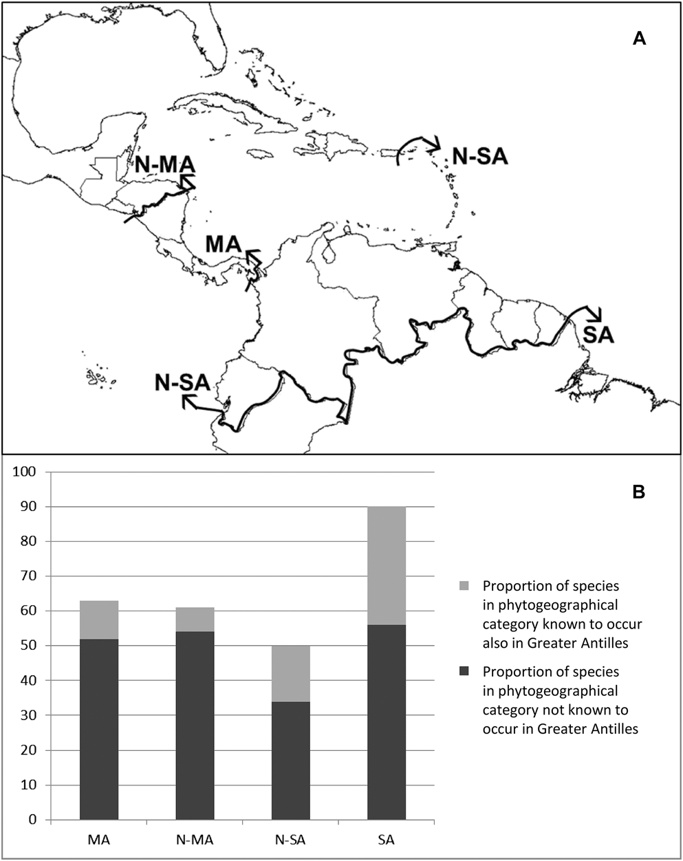
Brewer et al.’s (Reference Brewer, Rejmánek, Webb and Fine2003) studies have revealed differences in phytogeographical affinities between high elevation karstic vegetation types and lower elevation valley floor forests in the Bladen Nature Reserve in southern Belize (Fig. 1D). To explore the effect of phytogeography in our study, we recorded the phytogeographical affinities of each species in our dataset using Wendt’s (Reference Wendt, Ramamoorthy, Bye, Lot and Fa1993) coding method. Wendt’s (Reference Wendt, Ramamoorthy, Bye, Lot and Fa1993) delimitation separates Central and South American species into four phytogeographical units based on the known southernmost extent of a species’ distribution (Fig. 2): (1) northern Central America (N-MA), encompassing Mexico and the area north of the northern Nicaraguan border; (2) Mesoamerica (MA), including species assumed not to occur south of the southern Panamanian border; (3) northern South America (N-SA), with species occurring in the Guiana Shield and northwestern South America (including Colombia, Venezuela and Ecuador); and (4) South America (SA), with species reaching Brazil, Peru and further south. A fifth category was used following Wendt (Reference Wendt, Ramamoorthy, Bye, Lot and Fa1993) and Gentry (Reference Gentry1982a) to test whether floristic affinities existed with the Greater Antilles, to which Belize has close ties (Brewer, pers. comm.). Species occurring on islands including Puerto Rico northwards were coded part of the Greater Antilles, whereas species occurring on the Lesser Antilles (e.g. Windward and Leeward Islands, Trinidad and Tobago) were classified as part of the Guiana Shield (Fig. 2). Species distributions were recorded based on occurrence records available through the TROPICOS database (www.tropicos.org, Missouri Botanical Garden, accessed 9 May 2009).
(A) Map of Central and northern South America showing Wendt’s (Reference Wendt, Ramamoorthy, Bye, Lot and Fa1993) four phytogeographical categories along political boundaries. N-MA = Northern Mesoamerica, extending as far south as the northern Nicaraguan border; MA = Mesoamerica until eastern Panamanian border; N-SA = Northern South America including the Lesser Antilles, i.e. south from Puerto Rico; SA = South America south from northern borders of Peru and Brazil. (B) Distribution of Wendt’s phytogeographical categories across taxa from all study areas combined, i.e. a compilation of general collecting and quantitative surveys within the Chiquibul Forest. Known southernmost species distributions stem from TROPICOS accessed May 2009.
Results and Discussion
New species records for Belize and the Chiquibul
A total of 1359 voucher specimens were collected during the study, including 85 wood samples of lianas, 38 of which also have leaf material (Table 1). These collections represent 397 distinct taxa belonging to 87 families and 218 genera (Table 1). A total of 258 taxa (65%) were identified to species rank (including ‘cf.’ identifications), 56 (16%) taxa to genus, and 51 taxa (13%) to family only. Twenty-three (6%) taxa, including 10 lianas, remained unidentified even to family. Combining these figures with those of Bridgewater et al. (Reference Bridgewater, Harris, Whitefoord, Monro, Penn, Sutton, Sayer, Adams, Balick, Atha, Solomon and Holst2006a) brings the total numbers in the Chiquibul to 138 families, 688 genera, and 1344 species of angiosperms.
The collections revealed 28 new records compared to the CFRNP’s preliminary vascular plant checklist (Bridgewater et al., Reference Bridgewater, Harris, Whitefoord, Monro, Penn, Sutton, Sayer, Adams, Balick, Atha, Solomon and Holst2006a), plus a further 10 species with a cf. qualifier (Tables 1, 3). Three of these are new to Belize when compared to the latest national checklist (Balick et al., Reference Balick, Nee and Atha2000), namely Heteropterys obovata (Small.) Cuatrec. & Croat (Malpighiaceae), Inga nobilis Willd., and Lysiloma auritum (Schltdl.) Benth. (Leguminosae) (Tables 1, 3), though there are specimen records of Lysiloma auritum from Belize in Flora Mesoamericana (2014). Twenty of the 38 new records in the Chiquibul came from the karstic terrain above 500 m elevation.
Sample sites, coordinates, sampling methods and corresponding vegetation classification based on previous classification schemes
New records to the preliminary checklist of the vascular plants of the Chiquibul Forest, Belize (Bridgewater et al., Reference Bridgewater, Harris, Whitefoord, Monro, Penn, Sutton, Sayer, Adams, Balick, Atha, Solomon and Holst2006a) from this study, including 10 records that would be new to the Chiquibul, were their cf. qualifiers to be removed, shaded grey. See Methods and table footnotes for details
Collection localities are indicated: CR = Chiquibul River at Natural Arch, LR = Lower Raspaculo with h = hilltop, v = valley, s = slope, UR = Upper Raspaculo. New records are grouped according to phytogeographical affinity after Wendt (1993; N-MA = Northern Mesoamerica, MA = Mesoamerica, N-SA = Northern South America, SA = South America; † also present in the Greater Antilles).
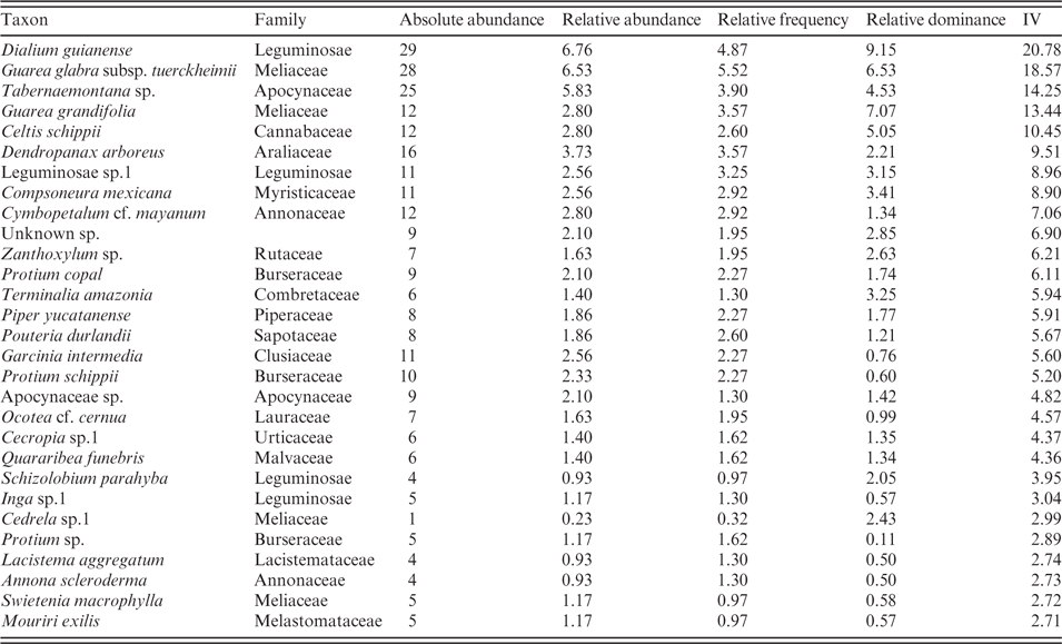
Nine of the 38 new records in the CFRNP were from Cuxta Bani in the Upper Raspaculo (Table 3). They were found growing exclusively on the metamorphic substrate. This area hosted the only representatives of Myristicaceae, namely Compsoneura mexicana (Hemsl.) Janovec and Virola koschnyi Warb. A further new record, Celtis schippii Standl. (Cannabaceae), was strongly represented here with 12 individuals in the 1 ha plot (Table 4). Several abundant morphospecies still await identification and will probably represent further new records to this area. Due to the difficulty of access, the area has remained poorly collected, and the new records show that more species remain to be added to the local flora from this area.
The 29 most important taxa in the Upper Raspaculo 1 ha plot at Cuxta Bani, representing two-thirds of the total taxa, in decreasing order of importance value (IV), based on absolute abundance, relative abundance, relative frequency and relative dominance
Nineteen of the new records to the Chiquibul vascular plant checklist come from the Lower Raspaculo, some of which also occurred in the karstic limestone area around Natural Arch along the Chiquibul River (Table 3). New records from the karstic limestone area in the Lower Raspaculo include 11 species of trees and shrubs, and eight lianas of which one is new to Belize. Of the 19 new records, nine were restricted to valley floors, seven to the hilltop vegetation, and only one occurred in both habitats, the latter a new record for Belize. The new records from the valley floor vegetation of the Chiquibul were Parathesis cf. rufa Lundell (Primulaceae), Pilea cf. ecboliophylla Donn.Sm. (Urticaceae), Piper sanctum (Miq.) Schltdl. ex C.DC. (Piperaceae), Trichilia martiana C.DC. (Meliaceae) and the recently re-instated Capparidastrum quiriguense (Standl.) Cornejo & Iltis (Capparaceae) (Cornejo & Iltis, Reference Cornejo and Iltis2008) which have Mesoamerican distributions, but there are only a few previous records from Belize. Nectandra martinicensis Mez (Lauraceae) is documented from southern Mesoamerica and northern South America based on records available in TROPICOS (2014), with only one record from Belize, for which no collector is given and the geo-referencing is approximate, but we made three independent collections of it in the Lower Raspaculo valley floor vegetation. New records from the karstic hilltop vegetation included the tree species Pseudobombax cf. ellipticum (Kunth) Dugand (Malvaceae), Croton niveus Jacq. (Euphorbiaceae), Coccoloba diversifolia Jacq. (Polygonaceae), Nectandra cf. coriacea (Sw.) Griseb. (Lauraceae), and Thouinia paucidentata Radlk. (Sapindaceae) (Table 3). These species are all relatively widespread across Central America and, in some cases, in northern South America and the Caribbean but, in Belize, only a few records are currently available in TROPICOS (2014). The one exception is Nectandra coriacea with 17 records from Belize.
Eight of the 19 new species in the Chiquibul recorded in the Lower Raspaculo are lianas. Lianas are generally under-represented in herbarium collections mainly because they are so difficult to collect. Our general collecting and vegetation transects included lianas and every effort was made to collect adequate material for identification, including wood, leaf and fertile material. The new records are Heteropterys obovata (Malpighiaceae), Marsdenia laxiflora Donn.Sm. (Apocynaceae), Bignonia potosina (K.Schum. & Loes.) L.G.Lohmann, Adenocalymma cf. inundatum Mart. ex DC. (Bignoniaceae), Gymnopodium floribundum Rolfe (Polygonaceae) and Machaerium cf. riparium Brandegee (Leguminosae). Schnella outimouta (Aubl.) Wunderlin vel aff. has not been marked as potentially new to the area. Two widespread species that extend their distributions from Central America to northern Argentina, Gouania cf. polygama (Jacq.) Urb. and Sageretia elegans (Kunth) Brongn. (Rhamnaceae), are here recorded in the Chiquibul for the first time.
Twelve of the new taxa occurred in the Chiquibul River area in Natural Arch but, as mentioned above, some overlapped in their distribution with the Lower Raspaculo study sites which are also on karstic limestone. They represented four trees and shrubs, five lianas and three herbs. The Chiquibul River area has not yet been exhaustively collected, although many more collections exist than in the remote Raspaculo valley. Our results suggest that between the three areas studied, there seems to be no geographical trend in the number of new records encountered, proving that many areas within the Chiquibul Forest are insufficiently studied. However, given that only one week was spent at Cuxta Bani (compared to three weeks at Natural Arch and seven around our Lower Raspaculo base), strictly collecting trees >10 cm DBH within one hectare, the rate at which new records were encountered at Cuxta Bani was clearly highest.
Upper Raspaculo at Cuxta Bani
Forest structure and species composition
The 1 ha plot in the Upper Raspaculo (Cuxta Bani) had a basal area (BA) for stems above 10 cm DBH of 78.2 m2 with more than 7% of stems reaching diameters >1 m DBH. Compared to the other study sites it was a much higher stature forest. While Meerman & Sabido (Reference Meerman and Sabido2001) lump this area into the same class as our Lower Raspaculo sampling sites, we have to agree with Penn et al. (Reference Penn, Sutton and Monro2004) that this vegetation type is different from areas sampled by us before and we can confirm their estimate of around 80 spp./ha (>10 cm DBH). The forest undergrowth was open with large tree ferns, fishtail palms (Xaté; Chamaedorea ernesti-augusti H.Wendl.) and less abundant liana cover. No signs of cutting of the Xaté palms were observed (see Bridgewater et al., Reference Bridgewater, Pickles, Garwood, Penn, Bateman, Porter Morgan, Wicks and Bol2006b), highlighting the remoteness of the area. The 10 most important taxa (based on abundance, frequency and BA) were Dialium guianense (Aubl.) Sandwith (Leguminosae), Guarea glabra Vahl subsp. tuerckheimii (C.DC.) T.D.Penn. (Meliaceae), Tabernaemontana sp. (morphospecies ‘Yellow IB Apocynaceae’), Guarea grandifolia DC. (Meliaceae), Celtis schippii (Cannabaceae), Dendropanax arboreus (L.) Decne. & Planch. (Araliaceae), Leguminosae sp.1, Compsoneura mexicana (Myristicaceae), Cymbopetalum cf. mayanum Lundell (Annonaceae), and one unknown species (Table 4). Species that were abundant but smaller in basal area included Garcinia intermedia (Pittier) Hammel (Clusiaceae) and Protium schippii Lundell (Burseraceae) (Table 4). Terminalia amazonia (J.F.Gmel.) Exell (Combretaceae) and Zanthoxylum sp. (Rutaceae) had high relative dominance but low relative abundance (Table 4). At least 41% of Penn et al.’s (2004; Table 2) species found at Cuxta Bani – and 64% including the ‘genus sp.’ identifications – overlap with our records but we did find both Protium copal (Schltdl. & Cham.) Engl. and Protium schippii in this area. It should be stated that a 26–30% overlap also existed with Penn et al.’s ‘Class 1’.
Chiquibul and Lower Raspaculo
Overview of vegetation transects
The four 0.1 ha vegetation transects (40 transects of 10 m × 2) established along the Chiquibul River and the Lower Raspaculo consisted of 1892 stems ≥2.5 cm DBH, yielding an average of 4730 stems ≥2.5 cm/ha. The 11 Chiquibul River transects at Natural Arch consisted of 539 stems, the 10 Lower Raspaculo valley floor transects had 501 stems, and the 11 Lower Raspaculo hilltop transects had 577 individuals. A further eight transects placed along slopes in the Lower Raspaculo included a total of 274 individuals. The vegetation structure was relatively homogeneous across most Lower Raspaculo and Chiquibul River sample sites, compared to the Upper Raspaculo site at Cuxta Bani. However, a stark difference in canopy height and forest structure was observed on the karstic hilltops above the Lower Raspaculo River. Chiquibul River and Lower Raspaculo sites had generally smaller trees with more stems, and relatively high abundance of lianas, except for hilltops, where liana abundance was low.
Table 2 shows the categorisation of the study areas according to previous vegetation classifications (Meerman & Sabido, Reference Meerman and Sabido2001; Penn et al., Reference Penn, Sutton and Monro2004). All transects mapped into lowland type forests, although hilltop sites were above 500 m elevation and would hence be considered by Meerman & Sabido in the ‘submontane’ category. Meerman & Sabido (Reference Meerman and Sabido2001) used Iremonger & Brokaw’s (Reference Iremonger, Brokaw and Wilson1995) species list to hypothesise frequent species for the UNESCO class ‘I.A.2.a.(1).(a).ST’ (Table 2). From their list, excluding those taxa we would not have sampled due to our >2.5 cm DBH size threshold, 39% did not occur in either of the three sampling locations, and 11% occurred in all three locations (namely Calophyllum brasiliense Cambess., Dendropanax arboreus and Terminalia amazonia). Hilltops only overlapped with 20–22% of the list, valley floors overlapped with 30–33% and Cuxta Bani with 41%.
Penn et al. (Reference Penn, Sutton and Monro2004) group all areas (except Cuxta Bani, Table 2) into the same category (Class 1, Deciduous forest), and our respective lists of taxa matched their species list by 33–48% (valley floors), 44–48% (hilltops) and 52% (Natural Arch). It is worth mentioning that species commonly found throughout otherwise heterogeneous vegetation types make up most of the matching taxa within our area (i.e. Dendropanax arboreus, Pouteria durlandii (Standl.) Baehni and Terminalia amazonia occurred throughout all four sample sites (Table 2), and Brosimum alicastrum Sw., Manilkara zapota (L.) P.Royen, Pleradenophora tuerckheimiana, Pseudolmedia spuria (Sw.) Griseb., Spondias mombin L. and Vitex gaumeri Greenm. were represented in all sampled areas except Cuxta Bani). High percentages of matching names therefore do not equal adequate description of the heterogeneity of the vegetation type itself. Penn et al. (Reference Penn, Sutton and Monro2004) do raise awareness of considerable local variation due to the dramatic topography of the area. Kelly et al. (Reference Kelly, Tanner, Kapos, Dickinson, Goodfriend and Fairbairn1988) ascribe structural differences in plant community composition measured across elevation gradients on Jamaican karst to locally differing water regimes but potentially also to differing degrees of historical disturbance. Local variation in plant community structure on karstic substrate is therefore to be expected (Trejo-Torres & Ackerman, Reference Trejo-Torres and Ackerman2002). Our results confirm this, and prove that ground-truthing is absolutely necessary to account for the fine-scale differences in species composition and environmental gradients in the heterogenic landscape.
Forest structure
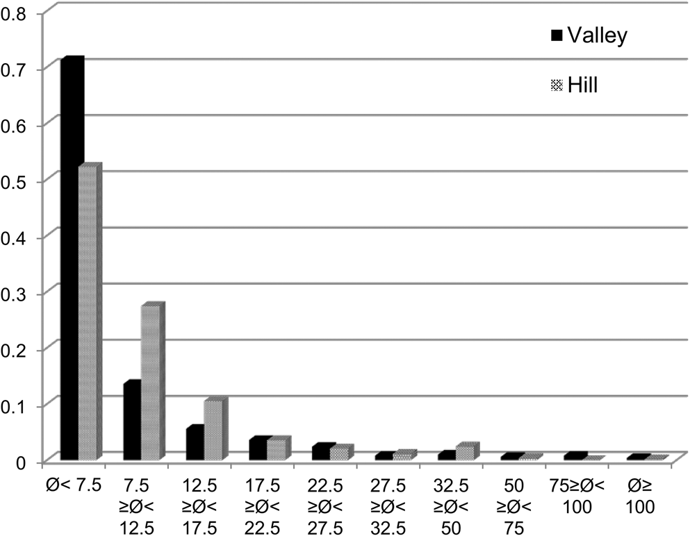
Transect data were used to compare forest structure, species composition, abundance, dominance, and importance value (IV) across the c.200 m elevation gradient from the valley floors at 400 m to the hilltops at 600 m in the Lower Raspaculo study area. Equal areas of 0.1 ha, respectively, were taken into account (Table 5; see below). The 0.1 ha on hilltops in the Lower Raspaculo showed slightly higher stem density with a total of 532 (52%) recorded stems (i.e. stem density of 5320 stems >2.5 cm DBH/ha), compared to an equal area of 0.1 ha on the Lower Raspaculo valley floors with 501 (48%) stems (i.e. stem density of 5010 stems >2.5 cm DBH/ha; Table 6). Similarly, 0.1 ha of Natural Arch transects near the Chiquibul River had a total of 494 stems (i.e. stem density of 4940 stems >2.5 cm DBH/ha). Within the Lower Raspaculo, total basal area (BA) was inversely proportional to stem density, with the hilltops having more stems but smaller basal area (BA; 8 m2) compared to valley floors with fewer stems but larger basal area (BA; 9.5 m2) (Fig. 3, Table 6). More than two-thirds of the valley vegetation fell into the small size category of <7.5 cm DBH compared to 52% in the hilltop vegetation (Fig. 3). Accordingly, a large proportion of hilltop vegetation fell into higher size categories, with nearly half of stems ≥7.5 cm DBH (Fig. 3). Lianas were found to be more diverse in terms of species numbers in the valley floor vegetation, with 32 recorded species compared to 12 species in the hilltop vegetation. These results are congruent with those of Brewer et al. (Reference Brewer, Rejmánek, Webb and Fine2003) who also found a significant increase in stem density with elevation above valley floors and observed a higher density and frequency of lianas in valley forests compared with ridge forests in the Bladen Nature Reserve. Bladen, at 350 km2 in area (Brewer et al., Reference Brewer, Rejmánek, Webb and Fine2003), borders the southeast of the Chiquibul and forms part of Belize’s contiguous rain forest block within the Maya Mountains. At Natural Arch, 78.3% of all stems were between 2.5 and 10 cm DBH, and 25.7% of all stems were lianas. Only six liana individuals at Natural Arch reached a diameter of >10 cm; therefore, lianas explained over 30% of all stems in the smallest size class, but only 5% of stems in the larger class.
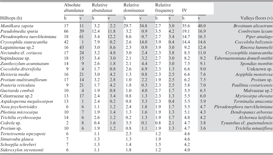
Taxa in order of highest importance from the Lower Raspaculo transects. Absolute and relative abundance, relative dominance, relative frequency and importance value (IV) indices are given, calculated per Gentry transect summing up to an area of 0.1 ha at each location. The taxa listed cumulatively explain two-thirds of the total transects’ importance values within a 0.1 ha area of hilltop and valley floor transects, respectively. Only a few taxa are listed as important on both the hilltops (h) and valleys floors (v), e.g. Cryosophila stauracantha and Pleradenophora tuerckheimiana
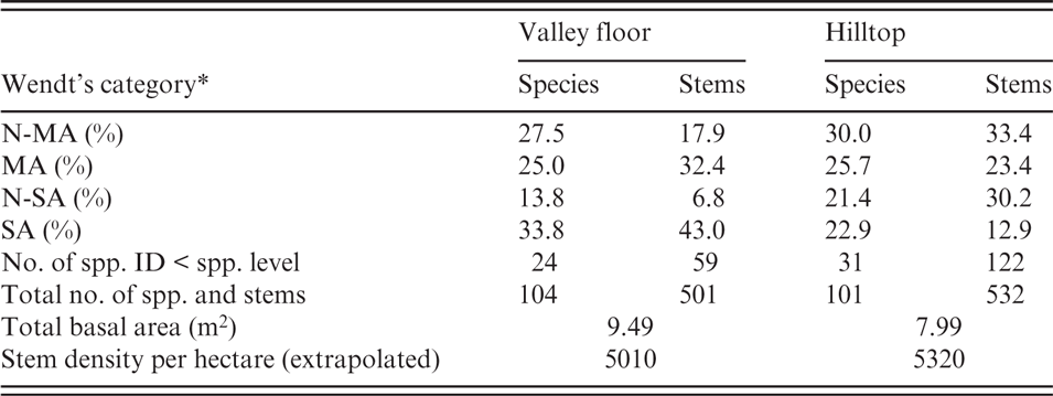
Comparison between the compositions of species and stems from the four phytogeographical categories (following Wendt, Reference Wendt, Ramamoorthy, Bye, Lot and Fa1993)
* N-MA = Northern Mesoamerica, MA = Mesoamerica, N-SA = Northern South America, SA = South America, from 0.1 ha of valley floor and 0.1 ha of hilltop flora >2.5 cm DBH; 100% equals the total number of species and stems identified to species level, on valley floors and hilltops, respectively.
Fractions of individuals (y-axis) occupying the indicated size classes (in cm DBH, here expressed with diameter symbol Ø on x-axis). Fractions from the valley and from the hilltop sample each add up to 1.
Species composition
A considerable overlap at the species level exists between the limestone forests of the Raspaculo and Chiquibul River valley with limestone assemblages of the Greater Antilles, for example Cuba, Hispaniola and Puerto Rico (Areces-Mallea et al., Reference Areces-Mallea, Weakley, Li, Sayre, Parrish, Tipton and Boucher1999) and, at least at generic rank, with Jamaica (Kelly et al., Reference Kelly, Tanner, Kapos, Dickinson, Goodfriend and Fairbairn1988). This is not surprising, given their geographical proximity. The 10 most important species in the Lower Raspaculo valley floors, according to the importance value (IV), were Brosimum alicastrum (Moraceae), Combretum laxum Jacq. (Combretaceae), Piper amalago L. (Piperaceae), Coccoloba belizensis Standl. (Polygonaceae), Rinorea hummelii Sprague (Violaceae), Cryosophila stauracantha (Heynh.) R.Evans (Arecaceae), Tabernaemontana donnell-smithii Rose (Apocynaceae), Spondias mombin (Anacardiaceae), Unknown sp.1, and Aegiphila monstrosa Moldenke (Lamiaceae) (Table 5). Species that were amongst the most abundant but which did not score highly in importance value due to their low basal area (BA) included Protium sp. (Burseraceae), Paullinia costaricensis Radlk. (Sapindaceae) and Myriocarpa obovata Donn.Sm. (Urticaceae) (Table 5). Terminalia amazonia (Combretaceae), Pleradenophora tuerckheimiana (Euphorbiaceae) and Malvaceae sp.2 had high relative dominance but low relative abundance (Table 5).
On hilltops, the most important taxa, based on the importance value (IV), included Manilkara zapota (Sapotaceae), Pseudolmedia spuria (Moraceae), Pleradenophora tuerckheimiana (Euphorbiaceae), Cryosophila stauracantha (Arecaceae), Leguminosae sp., Nectandra cf. coriacea (Lauraceae), Sapindaceae sp. (liana), Zanthoxylum acuminatum (Sw.) Sw. (Rutaceae; see also Brewer, Reference Brewer2013), Coccoloba diversifolia (Polygonaceae) and Heisteria media S.F.Blake (Olacaceae) (Table 5). Species that were amongst the most abundant but which did not score highly in importance value (IV) due to lower basal area (BA) included Protium multiramiflorum Lundell (Burseraceae), Trichilia erythrocarpa Lundell (Meliaceae), Celastraceae sp.2 and Aspidosperma megalocarpon Müll.Arg. (Apocynaceae) (Table 5). Neea psychotrioides Donn.Sm. (Nyctaginaceae) and Cedrela sp. (Meliaceae) scored highly in relative dominance due to the presence of a few large individuals (Table 5).
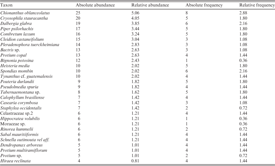
At Natural Arch, only abundance and frequency but not basal areas were recorded. Therefore, the following list of species from here is not commensurate with the lists above. However, noteworthy occurrences at Natural Arch (Table 7) were the most frequently recorded trees and shrubs Chionanthus oblanceolatus (B.L.Rob.) P.S.Green (Oleaceae), Spondias mombin (Anacardiaceae), Heisteria media (Olacaceae), the palm Cryosophila stauracantha and the lianas Dalbergia glabra (Mill.) Standl. (Leguminosae) and Combretum laxum (Combretaceae). Abundant but not as frequent as the above were Cleidion castaneifolium Müll.Arg. and Pleradenophora tuerckheimiana (Euphorbiaceae), Pouteria durlandii (Sapotaceae), Protium copal (Burseraceae), Piper psilorhachis C.DC. (Piperaceae), a palm Bactris sp. and the liana Bignonia potosina (Bignoniaceae).
The 29 most abundant taxa recorded at Natural Arch on the Chiquibul River, with absolute and relative abundances and frequencies. Total number of stems ≥2.5 cm was 494 within 10 transects of 0.1 ha (10 × 2 × 50 m)
Species overlap across Lower Raspaculo vegetation types
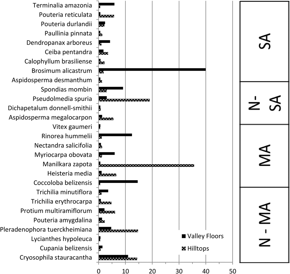
Only a few species recorded as important in the Lower Raspaculo valleys and hilltops were present in both vegetation types, for example the palm Cryosophila stauracantha and Pleradenophora tuerckheimiana (Euphorbiaceae) (Fig. 4, Table 5). Brosimum alicastrum (Moraceae), Rinorea hummelii (Violaceae), Spondias mombin (Anacardiaceae), Coccoloba belizensis (Polygonaceae), Myriocarpa obovata (Urticaceae) and Dendropanax arboreus (Araliaceae) were found to be characteristic of the valley floors but with low occurrence on the hilltops (Table 5). Species that show the opposite pattern of being characteristic elements of the hilltop vegetation but found in low numbers on the valley floors include Manilkara zapota, Pouteria reticulata (Engl.) Eyma (Sapotaceae), Heisteria media (Olacaceae), Pseudolmedia spuria (Moraceae), Aspidosperma megalocarpon (Apocynaceae) and Protium multiramiflorum (Burseraceae) (Table 5).
Comparison of the importance values (IV) of those species occurring in both vegetation types, i.e. the Lower Raspaculo valley floor and hilltop areas, as sampled from equal areas of 0.1 ha respectively, listed alphabetically within Wendt’s (Reference Wendt, Ramamoorthy, Bye, Lot and Fa1993) phytogeographical categories Northern Mesoamerican (N-MA), Mesoamerican (MA), Northern South American (N-SA) and South American (SA).
Pearson’s Chi-squared test indicated a statistically significant difference (χ-squared = 158.4537, df = 3, p-value <2.2 × 10⁻¹⁶) between valley floors and hilltops in respect to the distribution of stems from the four different phytogeographical categories. Of those species identified to species level, hilltops contained a significantly higher proportion of stems (33.4%) of species restricted to northern Mesoamerica (N-MA) than did the valley floors, where only 17.9% were made up of this category (Table 6). Similarly, the Northern South America category (N-SA) was more strongly represented on hilltops (30.2%) than on valley floors (6.8%). Of species commonly referred to as ‘generalists’, i.e. the South American (SA) category, stems were significantly more strongly represented on valley floors (43%) than on hilltops (12.9%). These results are congruent with Brewer et al.’s (Reference Brewer, Rejmánek, Webb and Fine2003) findings in the Bladen Nature Reserve in southern Belize, where valley floors were also found to be much more likely to be populated by generalist (SA) taxa.
Characteristic species
Characteristic species common and abundant in the valley floor vegetation included Brosimum alicastrum (Moraceae), Combretum laxum (Combretaceae), Piper amalago (Piperaceae), Coccoloba belizensis (Polygonaceae), Rinorea hummelii (Violaceae), Tabernaemontana donnell-smithii (Apocynaceae), Spondias mombin (Anacardiaceae), Paullinia costaricensis (Sapindaceae) and Aegiphila monstrosa (Lamiaceae). These species did not occur in high abundance in the hilltop vegetation nor the Upper Raspaculo forest on metamorphic substrates. In our hilltop vegetation sample, characteristic species were Manilkara zapota (Sapotaceae), Pseudolmedia spuria (Moraceae), Leguminosae sp.6, Nectandra cf. coriacea (Lauraceae), Zanthoxylum acuminatum (Rutaceae), Coccoloba diversifolia (Polygonaceae), Protium multiramiflorum (Burseraceae), Trichilia erythrocarpa (Meliaceae), Neea psychotrioides (Nyctaginaceae) and Heisteria media (Olacaceae). On the metamorphic rather than karstic substrate at Cuxta Bani, the list of characteristic taxa included Dialium guianense (Leguminosae), Guarea glabra subsp. tuerckheimii (Meliaceae), Tabernaemontana sp. (Apocynaceae), Guarea grandifolia (Meliaceae), Celtis schippii (Cannabaceae), Leguminosae sp.1, Compsoneura mexicana (Myristicaceae), Cymbopetalum cf. mayanum (Annonaceae), Garcinia intermedia (Clusiaceae) and Protium schippii (Burseraceae). Terminalia amazonia (Combretaceae) was common but also present in the riparian vegetation along the Lower Raspaculo downriver.
Several congeneric species pairs were found to occur in different vegetation types. One of these was Coccoloba, in which Coccoloba belizensis was an important component of the Lower Raspaculo valleys, whilst Coccoloba diversifolia and, to a lesser extent, Coccoloba acapulcensis Standl. occurred on the hilltops. Allophylus cominia (L.) Sw., Trichilia erythrocarpa (also T. minutiflora Standl. and T. moschata Sw.), Hampea trilobata Standl. and Randia cf. matudae Lorence & Dwyer occurred on hilltops – also reported in Brewer (Reference Brewer2013) from Oak Ridge, Bladen Nature Reserve – whilst Allophylus camptostachys Radlk., Trichilia minutiflora (also T. erythrocarpa), Hampea stipitata S.Watson and Randia retroflexa Lorence & M.Nee occurred on valley floors. Piper amalago was dominant in Lower Raspaculo valleys, whilst Piper yucatanense C.DC. was found, to a lesser degree, dominant in Upper Raspaculo (Tables 4, 5). Zanthoxylum acuminatum and Pouteria reticulata dominated in Lower Raspaculo hilltops whilst Zanthoxylum sp. and Pouteria durlandii dominated in Upper Raspaculo. Care should be taken when comparing the presence and abundance of these species between Lower and Upper Raspaculo because only stems ≥10 cm were recorded in the Upper Raspaculo and stems ≥2.5 cm were recorded in the Lower Raspaculo. It would be interesting to test the environmental niche width of these species pairs, as their respective occurrences suggest specialised adaptations to the different habitat types.
Implications for conservation
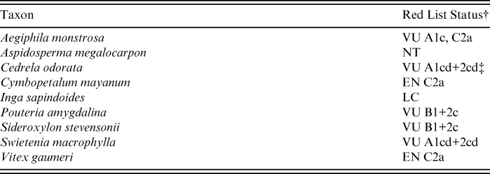
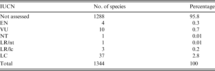
The Red List of the International Union for Conservation of Nature (IUCN) considers 33 plants to be threatened in Belize (one Critically Endangered, 13 Endangered and 19 Vulnerable) and a further 130 to be of lesser concern (four Near Threatened, two Data Deficient and 124 of Least Concern; IUCN, 2014). Both of our study sites – the Chiquibul River (CR) and Raspaculo River (LR; UR) – hosted nine species that have been assessed in the Red List (IUCN), and seven of these are threatened (Tables 8, 9). However, we found that 96% (257/267) of the species are not yet assessed by the IUCN Red List. This percentage persists when checking the combined list of Bridgewater et al. (Reference Bridgewater, Harris, Whitefoord, Monro, Penn, Sutton, Sayer, Adams, Balick, Atha, Solomon and Holst2006a) with our additional taxa (Table 9). Therefore, we checked the name entries in TROPICOS, which occasionally supplies more up-to-date and additional information on conservation status of some groups of taxa, even if often at national level (Charlotte Taylor, pers. comm. 2014) (Table 8). Considering our finds and those taxa reported in Bridgewater et al. (Reference Bridgewater, Harris, Whitefoord, Monro, Penn, Sutton, Sayer, Adams, Balick, Atha, Solomon and Holst2006a), at least 58% of all threatened vascular plant taxa of Belize are represented in the Chiquibul Forest alone. Frequently recorded in valley floor vegetation was the Vulnerable Aegiphila monstrosa; Near Threatened Aspidosperma megalocarpon was recorded several times on the Lower Raspaculo hilltops; and the Endangered Cymbopetalum [cf.] mayanum and the Vulnerable Swietenia macrophylla were recorded many times from the Upper Raspaculo Cuxta Bani plot. The Vulnerable taxa Pouteria [cf.] amygdalina and Sideroxylon stevensonii (Standl.) Standl. & Steyerm. were recorded a few times in the higher elevation forest types both in the Lower Raspaculo and at Natural Arch. The Endangered Vitex gaumeri was recorded four times in total at Natural Arch and Lower Raspaculo. Bridgewater et al. (Reference Bridgewater, Harris, Whitefoord, Monro, Penn, Sutton, Sayer, Adams, Balick, Atha, Solomon and Holst2006a) state that, in the Chiquibul Forest, several of the IUCN assessed plant species are locally fairly abundant compared to their entire Mesoamerican distribution. Therefore, the Chiquibul is a key area within the Maya Forest for biodiversity conservation. Although the Chiquibul is legally protected, there has been an increase of illegal activities including poaching and illegal logging (Briggs et al., Reference Briggs, Mazzotti, Harvey, Barnes, Manzanero, Meerman, Walker and Walker2013). Furthermore, the Chiquibul Forest is located within Cayo District; of the total deforestation that occurred in Belize between 2010 and 2012, some 35% occurred in Cayo (Cherrington et al., Reference Cherrington, Cho, Waight, Santos, Escalante, Nabet and Usher2012). This is not surprising since there has been a steady decline in the Mayan Forests’ cover in Belize averaging ∼10,000 ha/year (0.6%) over the last three decades, where ∼15.2% has occurred within protected areas (Cherrington et al., Reference Cherrington, Ek, Cho, Howell, Hernandez, Anderson, Flores, Garcia, Sempris and Irwin2010). The total deforestation in the Maya Forests is a major concern due to its high biodiversity value (Myers et al., Reference Myers, Mittermeier, Mittermeier, Da Fonseca and Kent2000; Conservation International, 2004; Young, Reference Young2008; Briggs et al., Reference Briggs, Mazzotti, Harvey, Barnes, Manzanero, Meerman, Walker and Walker2013). The data gathered from this study will serve to emphasise the importance of the Chiquibul, and can be used for the development of conservation and management plans in the region.
IUCN Status for assessed species from the present study (not including Bridgewater et al., Reference Bridgewater, Harris, Whitefoord, Monro, Penn, Sutton, Sayer, Adams, Balick, Atha, Solomon and Holst2006a); from the Red List itself and, if applicable, from the TROPICOS main database, with respective reference of publication*
* Note that TROPICOS does not usually duplicate the conservation status information from the Red List, but it does sometimes refer to taxon assessments published elsewhere that are not yet available in the Red List, or done on a national scale.
† LC = Least Concern, NT = Near Threatened (Lower Risk), EN = Endangered, VU = Vulnerable (Threatened); for ‘hierarchical alphanumeric numbering system of criteria and subcriteria’, please refer to IUCN (2014).
‡ Pennington & Muellner (Reference Pennington and Muellner2010) indicate LC status.
Percentages of species in IUCN Red List categories from both the present study and Bridgewater et al.’s (Reference Bridgewater, Harris, Whitefoord, Monro, Penn, Sutton, Sayer, Adams, Balick, Atha, Solomon and Holst2006a) angiosperm species list combined; less than 5% of species reported from the Chiquibul have been assessed by IUCN
Conclusion
The data from this expedition constitute a first step to filling knowledge gaps in plant diversity in the remote eastern Chiquibul National Park. The number of new records found in the Upper Raspaculo confirms our relatively poor knowledge of the Chiquibul flora in areas of metamorphic rather than karstic substrate. Since our survey in the Upper Raspaculo was relatively short and covered only trees above 10 cm DBH, further expeditions in this area will be important to gather missing data for the Chiquibul plant inventory. Based on our results, we expect that many more species not yet recorded will be found. Our study supports Bridgewater et al.’s (Reference Bridgewater, Harris, Whitefoord, Monro, Penn, Sutton, Sayer, Adams, Balick, Atha, Solomon and Holst2006a) conclusions that the higher altitudes within the Chiquibul Forest are the most poorly collected and are expected to deliver many more new records to the local flora. We found 38 new records in the Chiquibul, 20 of which came from the karstic terrain above 500 m elevation. Additionally, our list reveals that, within our study area in the CFRNP, there are at least 58% of the threatened plant species listed for Belize (IUCN, 2014). However, 96% of the species in our inventory have not yet been globally assessed in the IUCN Red List. Given the biodiversity value of the Chiquibul Forest, our results stress the pressing need for further botanical inventories and the urgency required in producing threat assessments of its plant species.
Acknowledgements
The authors would like to thank the following plant family experts for plant identifications: Actinidiaceae, Staphyleaceae and Caprifoliaceae: C. Whitefoord (BM); Annonaceae: P. Maas (U); Bignoniaceae, Euphorbiaceae, Malvaceae and Urticaceae: R. Akers (BM) and Z. Goodwin (E); Lauraceae: J. G. Rohwer (HBG); Leguminosae: G. Lewis, L. Rico (Cojoba), T. Pennington (Inga) and B. Klitgaard (Platymiscium) (K); Meliaceae and Sapotaceae: T. Pennington (K); Celastraceae, Melastomataceae and Rhizophoraceae: R. Liesner (MO); Moraceae: C. C. Berg (BG); Myrtaceae and Ochnaceae: C. Costion (E); Oleaceae: A. Monro (BM); Rosaceae: J. Ratter (E); Rubiaceae: C. Taylor (MO), as well as the TROPICOS database managers, in particular Robert Magill for expediting special requests.
We would like to thank the Forest Department of Belize for supporting this work, and the Geography Department at the University of Edinburgh, in particular P. Furley and K. Viergever, for their assistance in preparing the expedition. Further thanks are due to the Belize Defence Force, the British Army, the 69 Gurkha Field Squadron on Ex SAILFISH, and staff of the Belize Electric Company Ltd (BECOL). The authors would also like to thank TrekFORCE and their dedicated volunteers of 2006 without whom the participants would not have made it to Cuxta Bani. Funding for the expedition was kindly granted by the University of Edinburgh’s Davis Expedition Fund, the Royal Scottish Geographical Society, the Royal Geographical Society, the Carnegie Trust, the William Dickson Travelling Fund, the Barnston Bequest and the Weir Fund. Part of the data analysis was financially supported by the Royal Botanic Garden Edinburgh’s Sibbald Trust.