1. Introduction
The Central Asian Orogenic Belt (CAOB) is a giant accretionary orogenic belt between the Siberian Craton and the North China–Tarim cratons (Sengör, Natal'in & Burtman, Reference Sengör, Natal'in and Burtman1993; Jahn et al. Reference Jahn, Capdevila, Liu, Vernon and Badarch2004; Windley et al. Reference Windley, Alexeiev, Xiao, Kröner and Badarch2007; Xiao et al. Reference Xiao, Windley, Huang, Han, Yuan, Chen, Sun, Sun and Li2009, Reference Xiao, Huang, Han, Sun and Li2010; Kröner et al. Reference Kröner, Kovach, Belousova, Hegner, Armstrong, Dolgopolova, Seltmann, Alexeiev, Hoffmann, Wong, Sun, Cai, Wang, Tong, Wilde, Degtyarev and Rytsk2014). It was built up by multiple subduction/accretionary processes along with the closure of the Palaeo-Asian Ocean and involved a variety of tectonic units such as Precambrian microcontinents, ancient island arcs, fragments of oceanic islands and seamounts, accretionary complexes and passive continental margins (Mossakovsky et al. Reference Mossakovsky, Ruzhentsev, Samygin and Kheraskova1993; Sengör, Natal'in & Burtman, Reference Sengör, Natal'in and Burtman1993; Jahn, Reference Jahn, Malpas, Fletcher, Ali and Aitchison2004; Windley et al. Reference Windley, Alexeiev, Xiao, Kröner and Badarch2007; Xiao et al. Reference Xiao, Huang, Han, Sun and Li2010, Reference Xiao, Windley, Sun, Li, Huang, Han, Yuan, Sun and Chen2015). However, the tectonic processes concerning the last-stage evolution of the Palaeo-Asian Ocean and the formation of the CAOB have been hotly debated (Wang & Liu, Reference Wang and Liu1986; Tang, Reference Tang1990; Sengör, Natal'in & Burtman, Reference Sengör, Natal'in and Burtman1993; Xiao et al. Reference Xiao, Windley, Hao and Zhai2003, Reference Xiao, Windley, Huang, Han, Yuan, Chen, Sun, Sun and Li2009; Windley et al. Reference Windley, Alexeiev, Xiao, Kröner and Badarch2007; Choulet et al. Reference Choulet, Chen, Cogné, Rabillard, Wang, Lin, Faure and Cluzel2013). Suggestions for the timing of the final closure of the Palaeo-Asian Ocean range from Late Devonian to Triassic (Xiao et al. Reference Xiao, Windley, Hao and Zhai2003; Charvet et al. Reference Charvet, Shu, Laurent-Charvet, Wang, Faure, Cluzel, Chen and De Jong2011; Xu et al. Reference Xu, Charvet, Chen, Zhao and Shi2013; Eizenhöfer et al. Reference Eizenhöfer, Zhao, Zhang and Sun2014, Reference Eizenhöfer, Zhao, Sun, Zhang, Han and Hou2015a,Reference Eizenhöfer, Zhao, Zhang, Han, Hou, Liu and Wangb; Shao, Tang & He, Reference Shao, Tang and He2014; Li et al. Reference Li, Zhou, Brouwer, Xiao, Wijbrans and Zhong2014, Reference Li, Brouwer, Xiao and Zheng2017a,Reference Li, Brouwer, Xiao and Zhengb; Liu et al. Reference Liu, Zhao, Han, Eizenhöfer, Zhu, Hou and Zhang2017b).
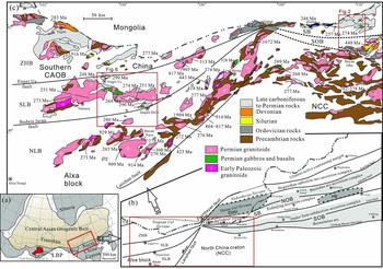
The Alxa block in westernmost Inner Mongolia of China is located at the triangle connecting the North China Craton to the east, the Tarim Craton to the west and the southernmost CAOB to the north (Fig. 1a, b). A Permian subduction system has been proposed to account for the lithostratigraphic and magmatic rocks in the northern Alxa block (Wu, He & Zhang, Reference Wu, He and Zhang1998; Feng et al. Reference Feng, Xiao, Windley, Han, Wan, Zhang, Ao, Zhang and Lin2013; Zheng et al. Reference Zheng, Wu, Zhang, Xu, Meng and Zhang2014; Liu et al. Reference Liu, Zhao, Han, Eizenhöfer, Zhu, Hou and Zhang2017b), and the Enger Us fault zone represents a part of the Tianshan–Solonker suture zones (Xiao et al. Reference Xiao, Windley, Hao and Zhai2003; Feng et al. Reference Feng, Xiao, Windley, Han, Wan, Zhang, Ao, Zhang and Lin2013; Zheng et al. Reference Zheng, Wu, Zhang, Xu, Meng and Zhang2014). However, the study of the Late Palaeozoic magmatic rocks in the Alxa block suggested an extensional setting triggered by the Tarim mantle plume (Dan et al. Reference Dan, Li, Wang, Tang and Liu2014a, Reference Dan, Wang, Wang, Liu, Wyman and Liu2015). The Late Palaeozoic tectonic settings in eastern Inner Mongolia are also hotly debated. For example, the Solonker Belt was considered as an Early Palaeozoic suture zone which was reworked by Permian extensional tectonics (Chen et al. Reference Chen, Zhang, Guo, Li, Feng and Tang2012; Xu et al. Reference Xu, Charvet, Chen, Zhao and Shi2013, Reference Xu, Zhao, Bao, Zhou, Wang and Luo2014; Shao, Tang & He, Reference Shao, Tang and He2014; Luo et al. Reference Luo, Xu, Shi, Zhao, Faure and Chen2016; Wang et al. Reference Wang, Wilde, Xu and Pang2016). By contrast, more studies tend to regard the Solonker Belt as a Late Palaeozoic zone, with Early Palaeozoic subduction zones distributing to its north and south (Xiao et al. Reference Xiao, Windley, Hao and Zhai2003, Reference Xiao, Windley, Sun, Li, Huang, Han, Yuan, Sun and Chen2015; Li et al. Reference Li, Zhou, Brouwer, Xiao, Wijbrans and Zhong2014, Reference Li, Brouwer, Xiao and Zheng2017a,Reference Li, Brouwer, Xiao and Zhengb; Eizenhöfer et al. Reference Eizenhöfer, Zhao, Sun, Zhang, Han and Hou2015a,Reference Eizenhöfer, Zhao, Zhang, Han, Hou, Liu and Wangb; Liu et al. Reference Liu, Li, Feng, Wen, Neubauer and Liang2017a).
(a) Simplified tectonic sketch map of China showing the location of the Alxa block and relationships with the North China Craton (NCC) and the Central Asian Orogenic Belt (CAOB). (b) Tectonic division of the CAOB in eastern Inner Mongolia and the Alxa region (after Badarch, Cunningham & Windley, Reference Badarch, Cunningham and Windley2002; Xiao et al. Reference Xiao, Windley, Hao and Zhai2003; Jian et al. Reference Jian, Liu, Kröner, Windley, Shi, Zhang, Shi, Miao, Zhang, Zhang, Zhang and Ren2008; Xu et al. Reference Xu, Charvet, Chen, Zhao and Shi2013; Zheng et al. Reference Zheng, Wu, Zhang, Xu, Meng and Zhang2014; Liu et al. Reference Liu, Li, Feng, Wen, Neubauer and Liang2017a). (c) Geological map of the Alxa block showing the distributions of the strata and magmatic rocks (modified after 1:200000 geological maps from NMBGMR, 1991 and Shi et al. Reference Shi, Wang, Zhang, Castro, Xiao, Tong, Zhang, Guo and Yang2014). SLB – Shalazhashan Belt; NLB – Nuru–Langshan Belt; ZHB – Zhusileng–Hangwula Belt; LBP – large basalt province in the Tarim; NOB – Northern Orogenic Belt; SOB – Southern Orogenic Belt; NCC – North China Craton; HB – Hunshandake Block; SMM – Southern Mongolia Microcontinent.

The provenance of the clastic rocks can help us better understand the tectonic history of the southernmost CAOB, and studies have been intensively carried out in eastern Inner Mongolia (e.g. Li et al. Reference Li, Chen, Wang, Hou and Liu2011; Eizenhöfer et al. Reference Eizenhöfer, Zhao, Zhang and Sun2014; Chen, Zheng & Zhao, Reference Chen, Zheng and Zhao2016) and the Tianshan orogens in NW China (e.g. Choulet et al. Reference Choulet, Cluzel, Faure, Lin, Wang, Chen, Wu and Ji2012a,Reference Choulet, Faure, Cluzel, Lin, Wang and Jahnb; Rojas-Agramonte et al. Reference Rojas-Agramonte, Kröner, Alexeiev, Jeffreys, Khudoley, Wong, Geng, Shu, Semiletkin, Mikolaichuk, Kiselev, Yang and Seltmann2014; Zhang et al. Reference Zhang, Zhang, Shao, Ying, Yang and Santosh2014b). However, provenance analysis in western Inner Mongolia is rare, which hinders our understanding of the CAOB in this region. The Upper Carboniferous to Permian sandstones in the northern Alxa block contain information about the depositional environment, source characteristics, palaeogeography and tectonic setting (Han et al. Reference Han, Liu, Li and Shi2012; Zhang et al. Reference Zhang, Wu, Feng, Zheng and He2013b; Shi et al. Reference Shi, Song, Wang, Huang, Zhang and Tang2016). This study collected six samples in western Inner Mongolia, including four sandstone samples in the Shalazhashan Belt (to the north of the Alxa block) and two samples in the Solonker Belt (in the Mandula area) to analyse their framework petrography, zircon morphology, U–Pb geochronology and Hf isotopes. Combining the new data with the previous studies, we can better unravel the tectonic-palaeogeographic history of the CAOB in western Inner Mongolia.
2. Geological setting
2.a. Lithotectonic units
2.a.1. The northern Alxa block
The northern Alxa block includes four tectonic belts from north to south, namely, the Yagan Belt, the Zhusileng–Hangwula Belt, the Shalazhashan Belt and the Nuru–Langshan Belt (Fig. 1b) (Wu, He & Zhang, Reference Wu, He and Zhang1998; Zheng et al. Reference Zheng, Wu, Zhang, Xu, Meng and Zhang2014; Liu et al. Reference Liu, Li, Feng, Wen, Neubauer and Liang2017a). The Yagan and Zhusileng–Hangwula belts crop out predominantly in the form of Carboniferous and Permian volcanic and volcaniclastic rocks, which unconformably cover the Silurian to Devonian sedimentary rocks and the Precambrian basement rocks composed of granitic gneiss, schist, migmatite, marble, quartzite and metasandstone of Mesoproterozoic to Neoproterozoic ages (e.g. NMBGMR, 1991; Wang, Wang & Wang, Reference Wang, Wang and Wang1994; Wu, He & Zhang, Reference Wu, He and Zhang1998; Wang et al. Reference Wang, Zheng, Gehrels and Mu2001). Wang et al. (Reference Wang, Zheng, Gehrels and Mu2001) and Zhou et al. (Reference Zhou, Han, Xu, Ren and Su2013), respectively, reported zircon U–Pb ages of 916±16 Ma and 905±6 Ma for the granitic gneiss in the Zhusileng–Hangwula Belt (Fig. 1).
The Shalazhashan Belt is separated by the Enger Us fault from the Zhusileng–Hangwula Belt and contains minor Early Palaeozoic magmatic rocks (Fig. 1b), but widespread Late Palaeozoic magmatic plutons including voluminous 247–301 Ma granitoids and minor 249–264 Ma diorites and gabbros (e.g. Dan et al. Reference Dan, Li, Wang, Tang and Liu2014a; Liu et al. Reference Liu, Li, Feng, Wen, Neubauer and Liang2017a). The Shalazhashan Belt crops out as sedimentary rocks of the Upper Carboniferous to Permian Amushan Formation, which is composed of volcanic and volcaniclastic rocks, and neritic carbonates and clastic rocks (e.g. Bu et al. Reference Bu, Niu, Wu and Duan2012; Zhang et al. Reference Zhang, Wu, Feng, Zheng and He2013b; Shi et al. Reference Shi, Song, Wang, Huang, Zhang and Tang2016).
The Nuru–Langshan Belt, separated by the Badain Jaran fault from the Shalazhashan Belt, is predominantly composed of Precambrian basement rocks including high-grade metamorphic supracrustal rocks with a deposition age of ~ 2.7 Ga and metamorphic ages ranging from 2.5 to 2.7 Ga and 1.9 to 2.0 Ga (Geng et al. Reference Geng, Wang, Shen and Wu2007), and Palaeoproterozoic gneisses, meta-clastic rocks and meta-carbonatites (NMBGMR, 1991; Li, Reference Li2006; Hu et al. Reference Hu, Gong, Wu, Liu and Liu2014). The Neoproterozoic strata, designated the Langshan group, are composed of meta-sandstones and volcanic intercalations with ages of 0.7–1.0 Ga. The meta-sandstones have detrital zircon age groups of 1.35 Ga, 1.5–1.6 Ga, 1.7–1.8 Ga and 2.4–2.6 Ga (Hu et al. Reference Hu, Gong, Wu, Liu and Liu2014). The Neoproterozoic granites are c. 0.8–1.0 Ga, and the Early Palaeozoic diorites and granitoids are c. 420–460 Ma. Late Palaeozoic mafic to felsic magmatic rocks with ages of c. 260–310 Ma are distributed in the Nuru–Langshan Belt (Geng & Zhou, Reference Geng and Zhou2010; Dan et al. Reference Dan, Li, Guo, Liu and Wang2012, Reference Dan, Li, Wang, Wang and Liu2014b, Reference Dan, Wang, Wang, Liu, Wyman and Liu2015; Wu et al. Reference Wu, Hu, Ren, Gong, Liu and Yan2014; Liu et al. Reference Liu, Li, Feng, Wen, Neubauer and Liang2017a; Wang et al. Reference Wang, Wilde, Xu and Pang2016).
The Langshan fault that separates the Alxa block from the North China Craton is a NE-trending sinistral shear fault. It occurred at c. 250 Ma (Zhang et al. Reference Zhang, Li, Xiao, Wang and Qi2013a; Fig. 1b, c).
2.a.2. The northern margin of the North China Craton (the Bayan Obo–Mandula areas)
Three main lithotectonic units are recognized from the Bayan Obo area ranging up to the Mandula area, namely, the North China Craton, the Southern Orogenic Belt and the Solonker Belt (Fig. 1b, c).
The North China Craton in the Bayan Obo area crops out as basement rocks of Neoarchaean–Palaeoproterozoic granitic gneisses and paragneisses with zircon U–Pb ages of ~ 2.5 Ga and 1.8–2.0 Ga (Fan et al. Reference Fan, Yang, Hu, Wang and Zhai2010; Liu et al. Reference Liu, Li, Ling and Sun2011, Reference Liu, Zhao, Liu and Shi2017c). The Meso- to Neoproterozoic Bayan Obo Group unconformably overlies these basement rocks and is composed of a thick sequence of low-grade metamorphosed supracrustal rocks, with detrital zircon U–Pb ages of 2.48–2.52 Ga, 1.85–1.95 Ga, 1.61–1.74 Ga, 1.53–1.55 Ga, 1.34–1.37 Ga and 1.13–1.18 Ga Liu et al. Reference Liu, Zhao, Liu and Shi(2017c). These rocks are unconformably overlain by Carboniferous–Permian strata (NMBGMR, 1991). Also, 1.31–1.35 Ga mafic sills, A-type granites and carbonatite dykes are found in the North China Craton (Zhang et al. Reference Zhang, Zhao, Yang, He and Wu2009c,Reference Zhang, Li, Evans, Wu, Li and Dong2012; Shi et al. Reference Shi, Liu, Kröner, Jian, Miao and Zhang2012a; Fan et al. Reference Fan, Hu, Yang, Pirajno, Liu and Wang2014). Late Palaeozoic granitic plutons are widespread along the northern margin of the North China Craton (Zhang et al. Reference Zhang, Zhao, Kröner, Liu, Xie and Chen2009a,Reference Zhang, Zhao, Song, Hu, Liu, Yang, Chen, Liu and Liub, Reference Zhang, Mao, Zhang, Zhai, Yang and Hu2011; Chen et al. Reference Chen, Zhang, Li, Chen, Tang and Li2015; Pang et al. Reference Pang, Wang, Xu, Luo and Liu2017).
The Southern Orogenic Belt, mainly exposed to the north of the E–W-striking Bayan Obo–Chifeng fault, consists of Ordovician to Early Silurian (c. 480–420 Ma) arc-related magmatic rocks and subduction accretionary complexes, and Upper Devonian sandstones (Jian et al. Reference Jian, Liu, Kröner, Windley, Shi, Zhang, Shi, Miao, Zhang, Zhang, Zhang and Ren2008; Shi et al. Reference Shi, Faure, Xu, Zhao and Chen2013; Xu et al. Reference Xu, Charvet, Chen, Zhao and Shi2013). The Southern Orogenic Belt was created by the southward subduction of the Palaeo-Asian oceanic crust during Early Palaeozoic time (Tang, Reference Tang1990; Jian et al. Reference Jian, Liu, Kröner, Windley, Shi, Zhang, Shi, Miao, Zhang, Zhang, Zhang and Ren2008; Xu et al. Reference Xu, Charvet, Chen, Zhao and Shi2013) or southward episodic subduction during Palaeozoic time (e.g. Zhang et al. Reference Zhang, Zhao, Kröner, Liu, Xie and Chen2009a; Chu et al. Reference Chu, Zhang, Wei, Wang and Ren2013; Peng et al. Reference Peng, Zhai, Li and Ripley2013; Li et al. Reference Li, Zhou, Brouwer, Xiao, Wijbrans and Zhong2014). Upper Carboniferous sedimentary rocks unconformably cover the pre-Devonian rocks and in turn are intruded by Permian igneous plutons (NMBGMR, 1991).
The Solonker Belt comprises a series of Upper Palaeozoic turbidites and small amounts of limestones, which were deposited in shallow- to deep-water environments (Shao, Reference Shao1991; Shang, Reference Shang2004). Ultramafic/mafic rocks generally crop out as lenses within the turbidites or mafic sills intruding into the sedimentary rocks (e.g. Shao, Reference Shao1991; Xiao et al. Reference Xiao, Windley, Hao and Zhai2003). The mafic rocks commonly show arc- or MORB-like geochemical features (e.g. Jian et al. Reference Jian, Liu, Kröner, Windley, Shi, Zhang, Zhang, Miao, Zhang and Tomurhuu2010; Luo et al. Reference Luo, Xu, Shi, Zhao, Faure and Chen2016). Voluminous Permian acidic volcanic rocks and equivalent intrusions are also widespread in the Solonker Belt (NMBGMR, 1991; Zhang et al. Reference Zhang, Chen, Li, Li, Yang and Qian2017).
3. Geology of the study areas
3.a. The Mandula area (the Solonker Belt)
3.a.1. Upper Palaeozoic sedimentary rocks
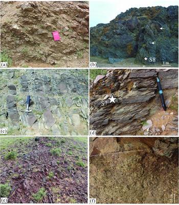
The Mandula area mainly exposes the Upper Carboniferous to Permian sedimentary and magmatic rocks (Figs 2, 3). The southern part of the Mandula area is dominated by limestones and sandstones ascribed to the Upper Carboniferous to Lower Permian Amushan Formation (C2–P1a, NMBGMR, 1991; the sandstone-rich units in the Amushan Formation are separated as the Benbatu Formation by BGIM, 2004 and Chen, Zheng & Zhao, Reference Chen, Zheng and Zhao2016). However, these limestones are olistoliths cemented into a siltstone-greywacke matrix and thus the rocks are considered as an olistostrome (G. Shi, unpub. Ph.D. thesis, Univ. d'Orléans, 2013). The olistostrome is characterized by metre- to kilometre-sized blocks of limestone, sandstone and volcanic rock. Based on the lithology of the block, the olistostrome can be divided into two types: sandstone-rich and limestone-rich. The sandstone-rich olistostrome is characterized by angular clasts and blocks of coarse sandstone, decimetres to several tens of metres in size, and subordinate and smaller, rounded clasts, and the matrix is greyish greywacke (Fig. 4a). The limestone-rich olistostrome contains limestone blocks ranging from kilometre- to metre-scale in the exposed longest dimension, and the matrix is greyish-green to dark grey and consists of slightly sandy mudstone (Fig. 4b). Rounded limestone blocks are occasionally found in the well-stratified turbidite of the Baotege Formation. The limestone olistoliths contain fossils of the Sphaeroschwagerina Biozone that is originally found in the limestones of the Amushan Formation exposed in the Southern Orogenic Belt. The olistostrome occurs mostly in the upper part of the Amushan Formation, particularly in the southern part of the Mandula area. The sandstone-rich olistostrome, ~ 1 km in width, occurs in the southern portion of the olistostrome, and the limestone-rich olistostrome, about 2–5 km in width, occurs in the northern portion of the olistostrome, transiting into the turbidite of the Baotege Formation.
Geological map of the Mandula area demonstrating the lithostratigraphic and magmatic rocks and tectonic division. The age of the basalt is according to Chen et al. (Reference Chen, Zhang, Guo, Li, Feng and Tang2012).

Stratigraphic columns of the Mandula, the Quagan Qulu and the Enger Us areas (modified after NMBGMR, 1991; Shi et al. Reference Shi, Song, Wang, Huang, Zhang and Tang2016).

Field photographs of the Upper Palaeozoic sandstones in the Mandula area. (a) The sandstone-rich olistostrome is dominated by various-sized blocks of sandstone. (b) The limestone-rich olistostrome is dominated by large-sized blocks of limestone and smaller sandstone; it represents a mixture of intrabasin autochthonous sediments and allochthonous limestones from the Early Palaeozoic orogens (the Southern Orogenic Belt). The white arrows mark the olistoliths of limestones. Sample S8 was taken from the matrix of the olistostrome. (c) The thick-bedded sandstone–mudstone couplets have common Bouma (Reference Bouma1962) Tcd divisions and rare Tabcd divisions. (d) The siltstone–mudstone laminae are composed of light grey siltstone and black mudstone. Sample S7 is taken from the fine-grained sandstone. (e) The red chert occurs as lenses in the turbidites in the Mandula area. (f) The conglomerate in the Zhesi Formation, c. 1 m thick, is composed of parallel pebbles. The hammer for scale is 30 cm long, the notebook is 20 cm long and the pen is 13 cm long.

The Lower Permian Baotege Formation (P1b) and a basaltic lava unit dated as 274 Ma (Chen et al. Reference Chen, Zhang, Guo, Li, Feng and Tang2012) crop out to the north of the olistostrome. The Baotege Formation is composed of well-stratified turbidites and intercalations of volcanic rocks (Fig. 3). The turbidite lithological types include thick- to medium-bedded sandstone, thick-bedded sandstone–mudstone couplets, thin-bedded sandstone–mudstone couplets, siltstone–mudstone laminae and chert.
The thick- to medium-bedded sandstone commonly forms packets ranging from 0.5–10 m thick. The sandstone is light brown, fine- to medium-grained, and massive to poorly horizontally laminated. Beds are commonly amalgamated and contain rare mudstone rip-up clasts at the basal level. The thick- to medium-bedded sandstone occurs mostly to the north of the olistostrome. Packets of thick- to medium-bedded sandstone are laterally continuous extending to the sandstone–mudstone couplets.
The thick-bedded sandstone–mudstone couplets form packets ranging from 0.1–50 m thick. The sandstone parts of the couplets are grey and fine grained, with Bouma (Reference Bouma1962) Tcd divisions common and Tabcd divisions rare (Fig. 4c). Rip-up clasts of black mudstone are commonly present at the base of the couplets. The mudstone parts of the couplets are black and display Bouma (Reference Bouma1962) Te divisions, or commonly grade into lime mudstone.
The thin-bedded sandstone–mudstone couplets are the most dominant lithological type and form packets up to 300 m thick in the outcrops. The sandstone parts of the couplets are light brown to dark grey and fine grained, with Bouma (Reference Bouma1962) Tcd divisions common. Locally, the sandstone is tuffaceous. The mudstone parts of the couplets are black and display Bouma (Reference Bouma1962) Tde divisions, or commonly grade into lime mudstone.
The siltstone–mudstone laminae lithological type is characterized by thin regular siltstone–mudstone laminae (Fig. 4d), forming packets ranging from 0.5–20 m thick. The siltstone parts of the laminae are light grey and the mudstone parts of the laminae are black and display Bouma (Reference Bouma1962) Te divisions, or commonly grade into lime mudstone or chert.
The chert is massive or slightly laminated, 3–5 m in thickness (Fig. 4e). The chert commonly occurs in the northwest of the Mandula area and contains radiolarian faunas (Wang et al. Reference Wang, Wang, Chen, Li, Su and Bai2005).
The Middle Permian Zhesi Formation (P2z) is c. 700–1000 m thick and comprises a lower part of mainly turbidite intercalated with limestone lenses, and an upper part of reddish and grey thick massive limestone and reef, conglomerate, coarse-grained sandstone and calcareous sandstone (Fig. 3). The turbidite of the Zhesi Formation is dominated by the lithological types of thick-bedded sandstone–mudstone couplets and thin-bedded sandstone–mudstone couplets, which are similar to the rhythm types of the Baotege Formation. The mudstone parts of couplets are black and commonly grade into lime mudstone or limestone lenses.
The upper part is dominated by massive limestone overlying the lower turbidite, a fringing reef extending several kilometres and an isolated reef body above sandstones, with a mixed fauna of Boreal, Tethyan and endemic elements (NMBGMR, 1991; Wang et al. Reference Wang, Wang, Chen, Li, Su and Bai2005; Shen et al. Reference Shen, Zhang, Shang and Li2006).
The conglomerate is characterized by disorganized pebbly sandstone, forming beds of 0.1 to 1 m thick (Fig. 4f). It is dark grey and consists of c. 40% clasts and 60% matrix. The clasts are well-rounded sandstone, mudstone, volcanic rocks and limestone in order of decreasing abundance. Occasionally, outsized limestone clasts (up to 2 m) are present in the conglomerate. The conglomerate commonly shows massive, weakly stratified or normally graded structures and mainly forms thick lens-shaped beds, laterally discontinuous in outcrops.
In the north of the Mandula area, the Lower–Middle Permian Dashizhai Formation (P1-2d) has the lithological composition of basaltic andesite, rhyolite, tuff, sandstone and silty mudstone (Zhang et al. Reference Zhang, Zhang, Tang, Wilde and Hu2008; Shao, Tang & He, Reference Shao, Tang and He2014; Zhang et al. Reference Zhang, Chen, Li, Li, Yang and Qian2017).
3.a.2. Other rocks in the Mandula area
The Southern Orogenic Belt exposed in the south of the Mandula area includes the subduction-related mélange rocks and the arc magmatic rocks with ages of c. 480–420 Ma (Fig. 2). These rocks are unconformably overlain by the Upper Silurian to Lower Devonian sedimentary successions of limestones and sandstones (Shi et al. Reference Shi, Faure, Xu, Zhao and Chen2013; Chen, Zheng & Zhao Reference Chen, Zheng and Zhao2016; Zhang & Zhang, Reference Zhang and Zhang2016). The Upper Carboniferous to Lower Permian Amushan Formation, unconformably overlying the Lower Palaeozoic rocks, is mainly composed of limestones, sandstones, silty mudstones and volcanic rocks, with a fossil assemblage of brachiopods, corals, ammonoids and fusulinids of the Sphaeroschwagerina Biozone and Triticites Biozone, suggesting a shallow-marine sedimentary environment (Yang et al. Reference Yang, Liu, Zhang, Li and Sun2015).
The rocks exposed in the North China Craton include the Meso- to Neoproterozoic Bayan Obo Group and the Permian volcanic rocks and granitic plutons (NMBGMR, 1991; Chen et al. Reference Chen, Zhang, Li, Chen, Tang and Li2015). The Bayan Obo Group consists of conglomerate, sandstone and limestone deposited in a rifted basin Liu et al. Reference Liu, Zhao, Liu and Shi(2017c).
3.b. The Shalazhashan Belt
3.b.1. Upper Palaeozoic sedimentary rocks
The Upper Palaeozoic strata in the Shalazhashan Belt crop out well in the Quagan Qulu area and the Enger Us area, and include the Upper Carboniferous to Lower Permian Amushan Formation and undifferentiated Upper Permian volcano-sedimentary rocks (Figs 3, 5). The Amushan Formation in the Quagan Qulu area includes three members (NMBGMR, 1991).
Geological map of the Quagan Qulu and Enger Us areas and tectonic divisions (modified after Zheng et al. Reference Zheng, Wu, Zhang, Xu, Meng and Zhang2014).

The lower member is predominantly composed of basaltic to dacitic volcanic rocks, volcaniclastic rocks, silty slate and minor limestone lenses, with fossils of the Triticites Biozone. The middle member, with a total thickness of 700–2000 m, is composed of thick- to medium-bedded limestone, calcareous sandstone and thin-bedded oolitic limestone and conglomeratic limestone. The limestones contain fossils of corals, brachiopods, ammonoids and fusulinids (Bu et al. Reference Bu, Niu, Wu and Duan2012).
The upper member of the Amushan Formation consists of a lower sandstone-dominated sequence and upper fine-grained sequence, with a thickness of 2 km or more. The lower sandstone is composed of metre-scale beds of coarse sandstone, pebbly sandstone and thin-bedded conglomerate (Fig. 6a). Bedding in the sandstone is tabular and commonly has cross-stratification (Fig. 6b). The upper fine-grained sequence is composed of red mudstone, siltstone and centimetre- to decimetre-scale interbeds of fine to coarse sandstone. The fine-grained lithologies are thick tabular beds of rippled or plane-laminated sandstone. Some beds, occurring within the mudstone, have sharp bases that grade upwards into massive or laminated siltstone, typical of Bouma sequence Tde divisions (Fig. 6c). The middle and upper members contain fusulinid fossils of the Pseudoschwagerina Biozone, indicative of Late Carboniferous to Early Permian ages (NMBGMR, 1991; Zhang et al. Reference Zhang, Wu, Feng, Zheng and He2013b). The Upper Permian in the Quagan Qulu area is composed of sandstones and volcanic rock intercalations of 254 Ma (Shi et al. Reference Shi, Song, Wang, Huang, Zhang and Tang2016).
Field photographs of the Upper Member of the Amushan Formation in the Quagan Qulu area. (a) The thick-bedded coarse sandstone in the lower part of the Upper Member of the Amushan Formation, where the sample WLJ-8 was taken from. (b) Locally the thick-bedded coarse sandstone developed cross-stratification, where the sample WLJ-5 was taken from. (c) The thin-bedded sandstone and mudstone couplets in the upper part of the Upper Member of the Amushan Formation. (d) The intercalation of the red chert (upper) and the tuffaceous siltstone (middle). The rocks develop N-dipping foliation (S1). (e) The rhythmic laminae of fine-grained sandstone and siltstone in the Enger Us area, where the sample NJ-7 was taken from. (f) The lens-shaped sandstone–mudstone couplets within the fine-grained dominant succession, where the sample WLJ-29-1 was taken from. The hammer for scale is 30 cm long and the lens cap is 7 cm in diameter.

The Enger Us area is characterized by a thick succession of thin-bedded fine-grained sandstone, siltstone, tuffaceous siltstone, shale and chert, with several beds of thin- to medium-bedded sandstone–mudstone couplets. In macroscopic view, basalts dated at 302–290 Ma are lenses cemented within the beds (Zheng et al. Reference Zheng, Wu, Zhang, Xu, Meng and Zhang2014; Shi et al. Reference Shi, Song, Wang, Huang, Zhang and Tang2016). The chert is commonly red, thin bedded, massive or laminated and can be laterally continuous for several decametres (Fig. 6d). The thin-bedded, fine-grained sandstone and siltstone are brown, dark grey and often form rhythmic laminae (Fig. 6e). The sandstone–mudstone couplets are brown and lens-shaped forms within the shale (Fig. 6f), and the sandstone bed normally has pebbly sandstone at the base and is upward-grading into siltstone or mudstone.
One outcrop in the Enger Us area, composed of a succession of siltstone, tuffaceous siltstone, mudstone and volcaniclastic rocks, has yielded a radiolarian fauna of late Middle Permian to early Late Permian age (Xie et al. Reference Xie, Yin, Zhou and Zhang2014), confirming the deposition was occurring in Middle to Late Permian times. However, the detailed distribution and thickness of the Middle to Upper Permian deposits are not well known (Figs 3, 5).
3.c. Sampling
A total of six sandstone samples were collected for detrital zircon U–Pb dating, and three of them were further selected for Lu–Hf isotopic measurement. Samples S7 and S8 were taken from the turbidites of the Baotege Formation (Lower Permian) and the matrix of the olistostromes, respectively (Figs 2, 4b, d). Samples WLJ-5 and WLJ-8 were taken from the coarse-grained sandstones in the Upper Member of the Amushan Formation in the Quagan Qulu area (Figs 5, 6a, b). Samples NJ-7 and WLJ-29-1 were taken from the turbidites in the Enger Us area (Figs 5, 6e, f).
4. Methodology
The petrographic texture and photomicrographs were studied using a polarized light microscope. The modal component statistics use the updated Gazzi–Dickinson counting method (Ingersoll et al. Reference Ingersoll, Bullard, Ford, Pickle and Sares1984; Dickinson, Reference Dickinson and Zuffa1985).
Detrital zircons were separated from the very fine sand fraction (0.10–0.063 mm) using a heavy liquid with specific gravity of 2.84 g/cm3. Then, zircon fragments were embedded in epoxy resin and polished to expose their inner structure. U–Pb dating, trace-element analysis and cathodoluminescence (CL) imaging were conducted by LA-ICP-MS at the Sample Solution Analytical Technology Co., Ltd, Wuhan. Detailed operating conditions and element correction follow Liu et al. (Reference Liu, Hu, Gao, Günther, Xu, Gao and Chen2008, Reference Liu, Gao, Hu, Gao, Zong and Wang2010) and Lin et al. (Reference Lin, Liu, Chen, Zhou, Hu and Gao2015). The dated grains were randomly selected without considering the grain shapes and internal structures, and the dating spots mainly focused on the core part of the zircon. Seventy grains were dated for each sample following the suggestion of Andersen (Reference Andersen2005) that the random selection should comprise 35–70 grains or more depending on the complexity of the age distribution. The U–Pb ages of lower than 94% concordance were not counted when calculating the relative probability for 206Pb–238U age using Isoplot/Ex_ver3 (Ludwig, Reference Ludwig2003). The counted number of valid zircon ages is between 53 and 65, generally equivalent to the number of 59 suggested by Dodson et al. (Reference Dodson, Compston, Williams and Wilson1988).
After the dating, the grains with valid Palaeozoic ages were selected for in situ zircon Hf isotopic analysis. A total of 61 grains from samples S7, S8 and WLJ-29-1 were analysed. Zircon Hf isotopic analysis was conducted at the State Key Laboratory of Geological Processes and Mineral Resources, China University of Geosciences (Wuhan). Detailed operating processes were described by Hu et al. (Reference Hu, Liu, Gao, Liu, Yang, Zhang, Tong, Lin, Zong, Li, Chen, Zhou and Yang2012). The crustal model age (TCDM) was calculated assuming that the parental magma was produced from an average continental crust (176Lu/177Hf = 0.015) that was originally derived from the depleted mantle. The 176Hf/177Hf and 176Lu/177Hf ratios of chondrite and depleted mantle at the present are 0.282772 and 0.0332, and 0.28325 and 0.0384, respectively (Blichert-Toft & Albarede, Reference Blichert-Toft and Albarede1997; Griffin et al. Reference Griffin, Belousova, Shee, Pearson and O'Reilly2004).
5. Results
5.a. Framework petrography
The detailed petrographic results are listed in Table 1.
Framework modes of the sandstone samples of the Upper Carboniferous to Permian sandstones in western Inner Mongolia

Qm – monocrystalline quartz grains; Qp – polycrystalline quartz grains; Pl – plagioclase; Kf – K-feldspar; Lv – volcanic grains; Ls – sedimentary grains; Ms – muscovite; Bi – biotite; M – matrix. Qt = Qm+Qp where Qt is total quartz grains; F = Pl+Kf where F is total feldspar; L = Ls+Lv+Ms+Bi where L is lithic fragments. Lt = L+Qp where Lt is total lithic fragments.
Sample S7, sandstone taken from the turbidite (Baotege Formation) in the Mandula area, is fine grained, well sorted and composed of quartz (39.5%), alkali feldspar (9.5%, mostly orthoclase), plagioclase (11.3%) and lithic fragments (35.5%). The lithic fragments are predominantly volcanic rocks (27.6%) and subordinately mudstone/siltstone fragments (5.6%). The volcanic fragments are mostly composed of tiny acicular or scaly felsic minerals, and opaque materials (Fig. 7). A small amount of muscovite (2.3%) is counted.
Petrographic photographs of the sandstones in the Solonker Belt (S7 and S8) and the Shalazhashan Belt (WLJ-5, WLJ-8, NJ-7, WLJ-29-1), in cross-polarized light. Lv – volcanic fragments; Bi – biotite; Ms – muscovite; Qm – monocrystalline quartz; Qp – polycrystalline quartz; Pl – plagioclase; K – K-feldspar.

Sample S8, sandy mudstone taken from the matrix of the olistostrome in the Mandula area, is mostly composed of mudstone matrix (79.0%), with grains of quartz and feldspar. The clastic grains are poorly sorted, ranging from ~ 0.1 mm to several centimetres (Fig. 7).
Sample WLJ-8, sandstone taken from the Upper Member of the Amushan Formation in the Quagan Qulu area, is coarse-grained sandstone, poorly sorted, angular to sub-angular in texture, showing characteristics of a low maturity of sandstone. The grain size varies considerably between 0.2 mm and 0.8 mm. It is composed of quartz (25.1%), lithic fragments (56.0%) and feldspar (12.6%). Volcanic rock (36.5%) predominates in the lithic fragments. There is a significant amount of biotite (11.8%) and muscovite (6.5%). The biotite is commonly curved owing to grain compression (Fig. 7).
Sample WLJ-5, sandstone taken from the Upper Member of the Amushan Formation in the Quagan Qulu area, is texturally immature, with very low degrees of rounding and sorting, and with grain sizes ranging from 0.2 mm to 0.6 mm (Fig. 7). It comprises quartz (26.1%), feldspar (10.4%) and abundant lithic fragments (56.0%). The proportion of the biotite and muscovite reaches up to 11.8%. Lithic fragments are mainly of a volcanic type (42.3%).
Sample NJ-7, siltstone taken from the turbidite in the Enger Us area, is quite fine grained (Fig. 7), well sorted and comprises quartz (44.7%), lithic fragments (28.1%) and feldspar (14.0%). The proportions of volcanic, sedimentary fragments and muscovite are 17.6%, 5.2% and 5.3%, respectively.
Sample WLJ-29-1, sandstone taken from the turbidite in the Enger Us area, is coarse grained, poorly sorted, sub-angular to sub-rounded in texture, and a few framework grains have developed cracks. It contains quartz (49.0%), lithic fragments (28.4%) and feldspar (19.3%). It has a significant amount of volcanic fragments (22.6%). Mudstone matrix is rare. The feldspar consists of alkali feldspar (mostly perthite) and plagioclase (Fig. 7).
5.b. Zircon U–Pb geochronology
The zircon U–Pb isotopic dating results for the six samples are listed in online Supplementary Material Table S1 available at http://journals.cambridge.org/geo. The concordia and probability density plots are shown in Figures 8 and 9.
The representative chondrite-normalized rare earth element (REE) patterns of zircons from the studied samples. Chondrite normalization values from Sun & McDonough (Reference Sun, McDonough, Saunders and Norry1989). The related CL images of the marked zircons are in the online Supplementary Figures S1–S3 available at http://journals.cambridge.org/geo.

U–Pb concordia diagrams for zircons from the sedimentary rocks of the Solonker Belt (S7 and S8) and the Shalazhashan Belt (WLJ-8, WLJ-5, NJ-7, WLJ-29-1).

In the sample S7, 53 out of 70 grains are concordant. The zircons are predominantly Palaeozoic (255–550 Ma) and yield two main age groups: (a) 270–330 Ma with a significant peak at 290 Ma and a secondary peak at 320 Ma; and (b) 420–550 Ma with a peak at 460 Ma and a secondary peak at 420 Ma. The subordinate groups include 1.4–1.5 Ga, 1.8–1.9 Ga and 2.3–2.6 Ga.
In the sample S8, 64 grains are concordant. The zircons have two main age groups: (a) 270–330 Ma with a significant peak at 295 Ma and a secondary peak at 330 Ma; and (b) 420–500 Ma with a peak at 438 Ma. The subordinate groups include c. 1.8–2.0 Ga and 2.4–2.6 Ga. One grain was dated at c. 1.4 Ga.
In the sample WLJ-5, 61 grains are concordant. The zircons have one main age group of 410–500 Ma with a significant peak at 433 Ma. The subordinate group is 0.9–1.0 Ga. Several zircon grains yield ages of c. 0.7 Ga, c. 1.9 Ga and c. 2.5 Ga.
In the sample WLJ-8, 64 grains are concordant. The zircons have one main age group of 410–550 Ma with a significant peak at 440 Ma. The subordinate groups include 0.9–1.0 Ga and 1.4–1.5 Ga. Several zircon grains yield ages of c. 1.2 Ga, c. 1.6 Ga and c. 2.5 Ga.
In the sample NJ-7, 55 grains are concordant. The zircons have one main age group of 420–500 Ma with a significant peak at 437 Ma. The subordinate groups include 0.9–1.0 Ga and 1.4–1.6 Ga. Several zircon grains yield ages of ~ 275 Ma, ~ 800 Ma and 1.8–1.9 Ga.
In the sample WLJ-29-1, 62 grains are concordant. The zircons have two main age groups: (a) 270–310 Ma with a significant peak at 290 Ma, and (b) 400–550 Ma with a significant peak at 420 Ma. The subordinate groups include 1.3–1.5 Ga and 1.7–1.9 Ga. Several zircon grains yield ages of ~ 780 Ma and ~ 1000 Ma.
5.c. Zircon morphology
Most zircon crystals are euhedral in shape, with sizes ranging from 50 to 150 μm. We divided the zircons into six groups according to the U–Pb ages: (a) 2.3–2.6 Ga, (b) 1.7–2.0 Ga, (c) 1.2–1.7 Ga, (d) 0.7–1.2 Ga, (e) 400–550 Ma and (f) 260–330 Ma. All the measured zircons show various complicated internal textures (online Supplementary Material Figs S1, S2, S3 available at http://journals.cambridge.org/geo). The zircons of 2.3–2.7 Ga age are generally rounded in shape, with a dark, homogeneous texture, or dark rim with light inner core. Some zircons of 1.7–2.0 Ga age are subhedral and commonly have an inner core of clear oscillatory zoning but a dark, homogeneous rim, and some grains have misted textures with no clear zoning. The zircons of 1.2–1.7 Ga and 0.7–1.2 Ga ages are complicated in that some zircons have weak or clear oscillatory zoning, but some are homogeneous without zoning, or have a dark rim or patchy forms. The Palaeozoic zircon grains usually have a tetragonal and prismatic shape with oscillatory zoning. Most zircons of 400–550 Ma age have clear oscillatory zoning, but a few grains show irregular sectors without zoning. All the zircons of 260–330 Ma age have oscillatory zoning.
5.d. Zircon chemistry
The results of zircon chemistry for the six samples are listed in online Supplementary Material Table S2 available at http://journals.cambridge.org/geo. Most detrital zircons from our sedimentary samples have high Th/U ratios (> 0.10), and are enriched in heavy rare earth elements (HREEs) compared to light rare earth elements (LREEs), with positive Ce anomalies and marked negative Eu anomalies (Fig. 10). Some grains show relatively flat LREE patterns, no or weakly positive Ce anomalies (e.g. S7: a2, a3; WLJ-8: a1; WLJ-5: e6). Grain c6 of sample NJ-7 (1369±32 Ma) has low LREE contents and Th/U ratio (< 0.10, see online Supplementary Material S2 available at http://journals.cambridge.org/geo). Grain b1 of sample S8 (1129±32 Ma) exhibits a flat HREE pattern.
Relative probability plots and age histograms for the detrital zircons of the Solonker zone (the Mandula area) and the Shalazhashan Belt (the Quagan Qulu area and the Enger Us area) in western Inner Mongolia. The U–Pb ages with concordance errors smaller than 94% are not counted (see online Supplementary Material Table S1 available at http://journals.cambridge.org/geo).

5.e. Lu–Hf isotopes
A total of 61 isotopic analyses were carried out on the dated detrital zircons of Palaeozoic ages (online Supplementary Material Table S3 available at http://journals.cambridge.org/geo). The Late Palaeozoic zircons from samples S7 and S8 have a dominant range from −5 to +7, with one grain having an extreme negative εHf(t) value of −17. The Early Palaeozoic zircons from sample S7 yield variable εHf(t) values from −7 to +8, with one grain (εHf(t) = −24) plotting on the 3.0 Ga evolution line (Fig. 11). Most zircons from samples S7 and S8 plot in the East CAOB field (Yang et al. Reference Yang, Wu, Shao, Wilde, Xie and Liu2006).
Plot of zircon U–Pb ages versus εHf(t) values. CHUR – chondritic uniform reservoir. The fields of the East CAOB and NCC are according to Yang et al. (Reference Yang, Wu, Shao, Wilde, Xie and Liu2006) and Zhang et al. (Reference Zhang, Zhang, Shao, Ying, Yang and Santosh2014c); and the fields of the Shalazhashan Belt and the Nuru–Langshan Belt are according to Dan et al. (Reference Dan, Li, Wang, Tang and Liu2014a, Reference Dan, Wang, Wang, Liu, Wyman and Liu2015), Liu et al. Reference Liu, Zhao, Han, Eizenhöfer, Zhu, Hou and Zhang(2017b), Shi et al. (Reference Shi, Wang, Zhang, Castro, Xiao, Tong, Zhang, Guo and Yang2014) and Zhang et al. (Reference Zhang, Wang, Zhang, Tong, Zhang, Shi, Guo, Huang, Yang, Huang, Zhao, Ye and Hou2015). CAOB – Central Asian Orogenic Belt; NCC – North China Craton; NLB – Nuru–Langshan Belt; SLB – Shalazhashan Belt.

The Late Palaeozoic zircons in sample WLJ-29-1 have εHf(t) values ranging from −5 to +11, and the Early Palaeozoic zircons yield εHf(t) values ranging from −9 to +5 (Fig. 11). The Late Palaeozoic zircons from WLJ-29-1 almost plot in the field of the Shalazhashan Belt, and the Early Palaeozoic zircons plot in the field of the Nuru–Langshan Belt. The zircons have a large range of TCDM ages (0.8–1.8 Ga), with a dominant population at 1.0–1.5 Ga (Fig. 11).
6. Discussion
6.a. Provenance analysis
6.a.1. The Solonker Belt (the Mandula area)
The limestone blocks in the olistostromes include fossils of the Sphaeroschwagerina Biozone, similar to the Amushan Formation exposed in the Southern Orogenic Belt, suggesting the Southern Orogenic Belt is one of the potential sources for the deposits of the Mandula area. This is consistent with the zircon age spectra that have an age peak at 438 Ma in sample S8 (the matrix of the olistostromes).
The zircons of 270–330 Ma age in samples S8 and S7 are subhedral to euhedral with variable zoning, high Th/U ratios (> 0.10), with positive Ce anomalies and marked negative Eu anomalies, which are diagnostic features of magmatic zircons (Hoskin & Ireland, Reference Hoskin and Ireland2000; Belousova et al. Reference Belousova, Griffin, O'Reilly and Fisher2002; Corfu et al. Reference Corfu, Hanchar, Hoskin and Kinny2003; Hoskin & Schaltegger, Reference Hoskin and Schaltegger2003). They might derive from two possible source areas, the northern margin of the North China Craton (including the Southern Orogenic Belt and the North China Craton) and the tectonic units of the CAOB (e.g. the Solonker Belt and the Northern Orogenic Belt; Jian et al. Reference Jian, Liu, Kröner, Windley, Shi, Zhang, Shi, Miao, Zhang, Zhang, Zhang and Ren2008; Xu et al. Reference Xu, Charvet, Chen, Zhao and Shi2013). The Late Carboniferous to Permian magmatic rocks are widespread in the northern margin of the North China Craton, the Solonker Belt and the Northern Orogenic Belt (Chen et al. Reference Chen, Jahn, Wilde and Xu2000; Zhang et al. Reference Zhang, Zhang, Tang, Wilde and Hu2008, Reference Zhang, Zhao, Kröner, Liu, Xie and Chen2009a, Reference Zhang, Zhang, Shao, Ying, Yang and Santosh2014a, Reference Zhang, Chen, Li, Li, Yang and Qian2017; Jian et al. Reference Jian, Liu, Kröner, Windley, Shi, Zhang, Zhang, Miao, Zhang and Tomurhuu2010; Tong et al. Reference Tong, Hong, Wang, Shi, Zhang and Zeng2010; Chen et al. Reference Chen, Zhang, Guo, Li, Feng and Tang2012; Hu et al. Reference Hu, Li, Xu, Zhong and Zhu2015). However, the Late Palaeozoic magmatic rocks in the northern margin of the North China Craton (the Bayan Obo area) have more negative zircon εHf values than that of the CAOB (Yang et al. Reference Yang, Wu, Shao, Wilde, Xie and Liu2006; Zhang et al. Reference Zhang, Zhao, Kröner, Liu, Xie and Chen2009a, Reference Zhang, Mao, Zhang, Zhai, Yang and Hu2011). Our zircon εHf values mainly plot in the field of the CAOB and the overlapping field of the CAOB and the North China Craton, indicating that the Late Palaeozoic magmatic rocks in the tectonic units of the CAOB are the main source. This is supported by the petrographic analysis, which shows the sandstones are immature, with a high proportion of volcanic fragments, suggesting a process of short distance transportation and proximal deposition. Moreover, the Late Palaeozoic zircons commonly have euhedral shapes, which is consistent with short distance transportation. Thus, we consider that the Late Palaeozoic volcanic rocks in the Solonker Belt and the Northern Orogenic Belt are the most plausible sources. The northern margin of the North China Craton as a subordinate source cannot be excluded owing to several zircons with negative zircon εHf values.
The Early Palaeozoic zircons (420–550 Ma) have clear oscillatory zoning, positive Ce anomalies and marked negative Eu anomalies, which are common features of igneous zircons. These zircons are most probably derived from the Southern Orogenic Belt. Voluminous Early to Middle Palaeozoic ages of arc-related magmatic rocks have been documented in this belt in response to the southward subduction of the Palaeo-Asian Ocean (Jian et al. Reference Jian, Liu, Kröner, Windley, Shi, Zhang, Shi, Miao, Zhang, Zhang, Zhang and Ren2008; Xu et al. Reference Xu, Charvet, Chen, Zhao and Shi2013; Zhang et al. Reference Zhang, Zhang, Shao, Ying, Yang and Santosh2014c; Fig. 12). The Lower to Middle Palaeozoic rocks of the Southern Orogenic Belt have a large range of zircon εHf values (Zhang et al. Reference Zhang, Zhang, Shao, Ying, Yang and Santosh2014c). Our measured zircon εHf values plot in a large range of –10 to +10 (Fig. 11). Considering the source of the limestone olistoliths, we suggest the Southern Orogenic Belt might provide clastic materials for the Carboniferous to Permian sandstones.
Comparison of the age spectra among the samples of the Shalazhashan Belt, the Solonker Belt and the potential source of the Southern Orogenic Belt. The data for the Southern Orogenic Belt and part of the zircons in the Mandula area are according to Chen, Zheng & Zhao (Reference Chen, Zheng and Zhao2016).

The Precambrian zircons might derive from the North China Craton. The Meso- to Neoproterozoic Bayan Obo Group contains detrital zircons of 2.48–2.52 Ga, 1.85–1.95 Ga, 1.61–1.74 Ga, 1.53–1.55 Ga, 1.34–1.37 Ga and 1.13–1.18 Ga ages Liu et al. Reference Liu, Zhao, Liu and Shi(2017c). Our results show the zircon grains of 2.3–2.6 Ga and 1.7–2.0 Ga are commonly rounded and subhedral, suggesting they have undergone long distance or multi-cycled transport processes. The core part of some zircons shows clear oscillatory zoning, whereas the rim is dark without zoning (online Supplementary Material Fig. S1 (S7: b1; S8: b5) available at http://journals.cambridge.org/geo), which is considered to indicate reworked igneous zircons (Hoskin & Black, Reference Hoskin and Black2000; Hoskin & Schaltegger, Reference Hoskin and Schaltegger2003). Some zircons have misted textures and no clear zoning, with relatively flat LREE patterns, corresponding to metamorphic origins (online Supplementary Material Fig. S1 (S8: b1) available at http://journals.cambridge.org/geo). The zircons of 1.2–1.7 Ga age show a homogeneous texture or contrasting rim texture, indicative of metamorphic or hydrothermal reworked zircons (online Supplementary Material Fig. S1 (S7: c1–c3) available at http://journals.cambridge.org/geo). Grain b1 of sample S8 (1129±32 Ma) exhibits a flat HREE pattern, suggesting coeval precipitation of zircon and garnet (Rubatto, Reference Rubatto2002). The complicated zircons are consistent with the basement rocks of the North China Craton. Thus, we suggest the zircons of 2.3–2.6 Ga and 1.7–2.0 Ga ages are related to the basement rocks of the North China Craton.
In summary, the Upper Carboniferous to Lower Permian sandstones in the Mandula area accommodated the sediments derived from the basement rocks of the North China Craton, the Early to Middle Palaeozoic magmatic rocks of the Southern Orogenic Belt, and the syn-depositional volcanic rocks (260–330 Ma) in the tectonic units of the CAOB (e.g. the Solonker Belt and the Northern Orogenic Belt).
6.a.2. The Quagan Qulu area (the Shalazhashan Belt, close to the Nuru–Langshan Belt)
In the Quagan Qulu area, the stratigraphic age of the Amushan Formation was confirmed by the fusulinids of the Pseudoschwagerina Biozone (NMBGMR, 1991), but the sandstones of the Amushan Formation have a main zircon age group of 410–500 Ma and a subordinate group of 0.7–1.1 Ga, lacking the Late Palaeozoic zircons. The cross-bedding preserved in the sandstones indicates the palaeo-current directions are from the southeast to northwest, and thus the Nuru–Langshan Belt is a possible source. The lack of Late Palaeozoic zircons can be explained by the Permian plutons in the source area having not been uplifted and eroded at the time of deposition of the Amushan Formation, or the sandstones in the Quagan Qulu area represent a different lithotectonic unit.
Almost all the Early Palaeozoic zircons have clear or weak oscillatory zoning and typical REE patterns of magmatic zircons, yet several grains show homogeneous or patchy textures and relatively flat LREE patterns, indicative of metamorphic origins (online Supplementary Material Fig. S2 (WLJ-8: e6–e8, WLJ-5: e6) available at http://journals.cambridge.org/geo). The Early Palaeozoic magmatic zircons might derive from the Early Palaeozoic (410–460 Ma) arc-related granitic and dioritic rocks exposed in the Nuru–Langshan Belt owing to the Palaeo-Asian Ocean subduction Liu et al. Reference Liu, Li, Feng, Wen, Neubauer and Liang(2017a). We speculate that the Early Palaeozoic metamorphic zircons are probably related to subduction/accretionary complexes, which are currently not exposed, or possibly hidden beneath the Mesozoic rocks in the Nuru–Langshan Belt.
The zircons of 0.7–1.0 Ga age are of magmatic types as suggested by the clear oscillatory zoning and typical REE patterns (Fig. 10). These zircons ages were reported in the volcanic layers of the Langshan group and the S-type granites in the Nuru–Langshan Belt (Dan et al. Reference Dan, Li, Wang, Wang and Liu2014b; Hu et al. Reference Hu, Gong, Wu, Liu and Liu2014).
The basement rocks or metamorphic rocks in the Nuru–Langshan Belt are important source rocks, as a significant amount of biotite, muscovite and garnet were found in the sandstones of the Amushan Formation (Shi et al. Reference Shi, Song, Wang, Huang, Zhang and Tang2016). Some zircons of 1.0–1.1 Ga age have features of magmatic zircons, whereas a few zircons of 1.0–1.1 Ga age show distinct features of metamorphic zircons (online Supplementary Material Fig. S2 available at http://journals.cambridge.org/geo). These zircons and related rock types are not well known in the Nuru–Langshan Belt. The grains of 1.3–1.5 Ga, 1.7–1.9 Ga and ~ 2.5 Ga ages are generally rounded and subhedral, a common feature of long distance or multi-cycle transportation. Some grains show relatively flat LREE patterns, and no or weakly positive Ce anomalies (e.g. WLJ-8: a1), representing the differences in source materials or subsequent metamorphism (Whitehouse & Platt, Reference Whitehouse and Platt2003). The complicated zircons could derive from the sedimentary rocks of the Neoproterozoic Langshan group which include similar age spectra (Hu et al. Reference Hu, Gong, Wu, Liu and Liu2014), or directly derive from the basement rocks of the Nuru–Langshan Belt.
In summary, the Nuru–Langshan Belt is the source area for the Upper Carboniferous to Lower Permian sandstones. The source rocks include the Early Palaeozoic arc-related magmatic rocks, the magmatic rocks of 0.7–0.9 Ga age, and possibly the Neoproterozoic Langshan group and the Palaeoproterozoic, Archaean basement rocks.
6.a.3. The Enger Us area (the Shalazhashan Belt, close to the Zhusileng–Hangwula Belt (CAOB))
The zircons of 270–320 Ma age in the Enger Us area show oscillatory zoning and typical REE patterns of magmatic zircons. Moreover, the εHf values are positive, plotting in the field of the CAOB (Fig. 11). This excludes the Nuru–Langshan Belt as the source area, as the Late Palaeozoic zircons of the Nuru–Langshan Belt have negative εHf values, similar to that of the North China Craton (Geng & Zhou, Reference Geng and Zhou2012; Dan et al. Reference Dan, Li, Wang, Tang and Liu2014a, Reference Dan, Wang, Wang, Liu, Wyman and Liu2015). The Late Palaeozoic magmatic rocks are widely distributed in the Shalazhashan Belt and the Zhusileng–Hangwula Belt, and the magmatic rocks are characterized by positive zircon εHf values (e.g. Shi et al. Reference Shi, Wang, Zhang, Castro, Xiao, Tong, Zhang, Guo and Yang2014). Considering the large proportion of volcanic fragments in the samples, the zircons of 270–320 Ma age should derive from the syn-depositional volcanic rocks in the Shalazhashan Belt and the Zhusileng–Hangwula Belt.
The zircons of 410–500 Ma age are related to the Early Palaeozoic magmatic rocks in the Nuru–Langshan Belt. Most zircons of 410–500 Ma age have clear oscillatory zoning of igneous zircons and have negative εHf values, which are consistent with the Early Palaeozoic zircons from the Nuru–Langshan Belt Liu et al. Reference Liu, Li, Feng, Wen, Neubauer and Liang(2017a).
Some zircons of 1.7–2.0 Ga age have the clear oscillatory zoning of igneous zircons, but some show dark homogeneous structures, or a light zoned inner core with dark rim, suggesting the zircons have undergone metamorphic reworking (online Supplementary Material Fig. S3 (WLJ-29-1: b3–b5) available at http://journals.cambridge.org/geo). The zircons of 1.4 Ga and 0.9–1.1 Ga ages, and some zircons of 1.5 Ga and 1.3 Ga ages have the weak or clear oscillatory zoning of igneous zircons, and all zircons of 1.6 Ga age and some zircons of 1.5 Ga and 1.3 Ga ages are homogeneous without zoning, or have a dark rim with light inner core (online Supplementary Material Fig. S3 (NJ-7: d1–d8) available at http://journals.cambridge.org/geo). Grain c6 of sample NJ-7 (1369±32 Ma) has low LREE contents and Th/U ratio (< 0.10), indicating a metamorphic origin. The Precambrian rocks in the Zhusileng–Hangwula Belt and the Nuru–Langshan Belt contain zircons of 0.7–1.2 Ga and 1.2–1.7 Ga ages (NMBGMR, 1991; Wang et al. Reference Wang, Zheng, Gehrels and Mu2001; Zhou et al. Reference Zhou, Han, Xu, Ren and Su2013). Therefore, the Precambrian zircons in the Enger Us area could be from both the Zhusileng–Hangwula Belt and the Nuru–Langshan Belt.
In summary, the Nuru–Langshan Belt, the Shalazhashan Belt and the Zhusileng–Hangwula Belt are the source areas for the Upper Carboniferous to Permian sandstones in the Enger Us area. The Late Palaeozoic volcanic rocks of the Shalazhashan Belt and the Zhusileng–Hangwula Belt are the sources for the zircons of 270–320 Ma age, whereas the Early Palaeozoic magmatic rocks in the Nuru–Langshan Belt are responsible for the zircons of 410–500 Ma age.
6.b. Sedimentary environment and palaeogeographic reconstruction
6.b.1. Lithofacies interpretations
6.b.1.a. The Mandula area
We interpreted the olistostrome as representing slump deposits developed on intrabasinal topographic highs (e.g. horsts) or basin margin shoulders, such as carbonate platforms, because the original carbonate rocks are widespread in the Amushan Formation of the Southern Orogenic Belt. The amount and size of the limestone blocks decreases northwards, and the matrix of the olistostrome is made of brown greywacke in the south and dark grey mudstones in the north, indicating a northward slumping process.
The thick- to medium-bedded sandstone of the Baotege Formation and the conglomerate of the Zhesi Formation are considered as hyperconcentrated density flow or debris flow deposits related to the slumping event (e.g. Lowe, Reference Lowe1982; Mulder & Alexander, Reference Mulder and Alexander2001). The thick- to medium-bedded sandstone is mainly distributed to the north of the olistostrome and probably represents the evolutional products of the slump deposits. The conglomerate of the Zhesi Formation is interpreted as debris flows that spread northwards over the turbidite, and the outsized limestone clasts were derived from limestone of the Amushan Formation. It appears to represent relatively short-term ‘catastrophic’ events related to major slides.
The sandstone–mudstone couplets (laminae) are interpreted as submarine fan lobe deposits in a turbidite system (e.g. Lowey, Reference Lowey2007). Based on the fine grain size and lamination, the turbidite is interpreted to have been deposited in low-energy, deep-water environments.
6.b.1.b. The Quagan Qulu and Enger Us areas
The middle member of thick- to medium-bedded limestone represents a carbonate platform (e.g. Bu et al. Reference Bu, Niu, Wu and Duan2012). As in the upper member of the Amushan Formation, the lower thick-bedded pebbly sandstone and coarse sandstone with cross-stratification are interpreted to represent neritic sea sedimentation within a high-energy environment; the upper fine-grained strata have a significant amount of mudstone and turbidite Tde divisions, which are interpreted as having been deposited in a deep basinal position within a relatively low-energy environment. The fine-grained succession in the Enger Us area represents deep-water environments of low energy and short of sand supply.
6.b.2. Sedimentary environment
The Late Palaeozoic sedimentary environments in western Inner Mongolia were intensively studied, but no consensus has been reached, because of the poor outcrops and the lack of precise stratigraphic ages (Shen et al. Reference Shen, Zhang, Shang and Li2006). The Upper Carboniferous to Permian sediments are generally deposited in shallow-marine environments (Mueller et al. Reference Mueller, Rogers, Jin, Wang, Li, Chronic and Joseph1991; Shen et al. Reference Shen, Zhang, Shang and Li2006; Li, Lu & Chen, Reference Li, Lu and Chen2011; Bu et al. Reference Bu, Niu, Wu and Duan2012; Li et al. Reference Li, Bai, Niu and Chen2012), though a deep-water environment was suggested according to the radiolarian fauna found in the mudstone of the Middle Permian strata (Shang, Reference Shang2004). Shao, Tang & He (Reference Shao, Tang and He2014) studied the Lower Permian strata in central Inner Mongolia and observed an upward-deepening sedimentary succession, and Li, Lu & Chen (Reference Li, Lu and Chen2011) argued that the Amushan Formation in western Inner Mongolia has undergone a transition from terrestrial to shallow-marine deposition.
For our field observations, the lithological assemblages of shallow-marine environments are mainly distributed in the Southern Orogenic Belt and the southern part of the Shalazhashan Belt (e.g. the Quagan Qulu area). The lithological assemblages indicating deep-water environments are mostly distributed in part of the Solonker Belt and the northern part of the Shalazhashan Belt (e.g. the Enger Us area). The transitional zone between the shallow- and deep-water environments often develops slump deposits (Fig. 13).
Sedimentary environments and palaeogeographic reconstruction of western Inner Mongolia.

In the Mandula area, the Amushan Formation in the Southern Orogenic Belt is composed of shallow-marine sediments characterized by lithological assemblages of reef limestone, sandstones and volcanic rocks, including fossils of brachiopods, corals, ammonoids and fusulinids (NMBGMR, 1991; Yang et al. Reference Yang, Liu, Zhang, Li and Sun2015). Northwards, the olistostromes represent the slump deposits developed in the transition zone from the shallow-marine to deep-water environments. Further north, the Baotege Formation is characterized by thin-bedded sandstone and mudstone (or silicified mudstone) couplets which contain radiolarian faunas, suggesting deep-water environments (Wang et al. Reference Wang, Wang, Chen, Li, Su and Bai2005). The Dashizhai Formation, characterized by the mudstones, siltstones and intercalations of volcanic and volcaniclastic rocks, represents volcanic eruption-related deposits in submarine environments (NMBGMR, 1991, Jiang et al. Reference Jiang, Xu, Zhao, Luo, Xiao and Luo1995). Therefore, we argue for generally northward-deepening environments.
The detrital zircon analyses also support the presence of northward-deepening sedimentary environments (Fig. 13). The Upper Palaeozoic sandstones in the Southern Orogenic Belt (shallow-marine environment) mainly accommodated the terrestrial clasts from the North China Craton and the Southern Orogenic Belt (Yang et al. Reference Yang, Liu, Zhang, Li and Sun2015; Chen, Zheng & Zhao, Reference Chen, Zheng and Zhao2016; Zhang & Zhang, Reference Zhang and Zhang2016). By contrast, the sandstones in the Solonker Belt (partly in deep-water environments) accommodated sediments from the North China Craton and the Southern Orogenic Belt, and also the Solonker Belt and the Northern Orogenic Belt.
The sedimentary rocks in the Shalazhashan Belt also demonstrate similar environments of northward deepening. The Amushan Formation in the Quagan Qulu area has lithological assemblages of thick-bedded sandstones and limestones, develops cross-bedding sedimentary structures, and contains fossils of brachiopods, corals, ammonoids and fusulinids, suggesting shallow-marine environments (Han et al. Reference Han, Liu, Li and Shi2012; Shi et al. Reference Shi, Song, Wang, Huang, Zhang and Tang2016). In contrast, the sedimentary formations in the Enger Us area are characterized by rhythmic beds of siltstone and silicified mudstone, and thin-bedded volcanic and volcaniclastic rocks deposited in relatively deep-water environments. Radiolarian faunas are also found in the Enger Us area (Xie et al. Reference Xie, Yin, Zhou and Zhang2014).
Our provenance analyses in the Shalazhashan Belt are also consistent with the presence of northward-deepening environments. The sediments in the Quagan Qulu area (shallow-water environment) derive from the Nuru–Langshan Belt to the south. However, the sediments in the Enger Us area (deep-water environment) derive from the Nuru–Langshan Belt to the south, and the Shalazhashan Belt and the Zhusileng–Hangwula Belt to the north.
6.b.3. Palaeogeographic reconstruction
We consider the Shalazhashan Belt to be the western extension of the Solonker Belt, because the Shalazhashan Belt and the Solonker Belt share similar detrital age spectra (Fig. 12). The Nuru–Langshan Belt was involved in the Early Palaeozoic Palaeo-Asian Ocean subduction event, the same as the Southern Orogenic Belt Liu et al. Reference Liu, Li, Feng, Wen, Neubauer and Liang(2017a). The palaeogeomagnetic and structural evidence also suggested that the Alxa block southwardly migrated along the Langshan fault relative to the North China Craton after Permian time (Zhang et al. Reference Zhang, Li, Xiao, Wang and Qi2013a; Yuan & Yang, Reference Yuan and Yang2015). When the Alxa block is restored to its initial position, the Southern Orogenic Belt and the Solonker Belt are parallel to the Nuru–Langshan Belt and the Shalazhashan Belt, respectively.
Our detrital zircons include a main age group of 410–500 Ma, suggesting that the Early Palaeozoic arc-related magmatic rocks in the Southern Orogenic Belt and the Nuru–Langshan Belt were uplifted to become erosion areas in Late Palaeozoic time (Fig. 13). Meanwhile, in the deep-water environments, the Late Palaeozoic calc-alkaline volcanic rocks were active in the Solonker Belt and the Shalazhashan Belt (Zhang et al. Reference Zhang, Zhang, Tang, Wilde and Hu2008, Reference Zhang, Chen, Li, Li, Yang and Qian2017; Chen et al. Reference Chen, Zhang, Guo, Li, Feng and Tang2012; Shi et al. Reference Shi, Wang, Zhang, Castro, Xiao, Tong, Zhang, Guo and Yang2014; Shao, Tang & He, Reference Shao, Tang and He2014), which provided the detrital zircons of 260–330 Ma age. The palaeogeography might be characterized by relatively high-relief landscapes or slope areas for the development of olistostromes (Fig. 13).
6.c. Tectonic setting
Some researchers suggested the northern margin of the Alxa block can be ascribed to a subduction setting during Late Carboniferous to Early Permian times (Shi et al. Reference Shi, Tong, Wang, Zhang, Zhang, Zhang, Guo, Zeng and Geng2012b; Feng et al. Reference Feng, Xiao, Windley, Han, Wan, Zhang, Ao, Zhang and Lin2013; Peng et al. Reference Peng, Zhai, Li and Ripley2013; Lin et al. Reference Lin, Xiao, Wan, Windley, Ao, Han, Feng, Zhang and Zhang2014; Wang et al. Reference Wang, Han, Feng and Liu2015; Liu et al. Reference Liu, Zhao, Han, Eizenhöfer, Zhu, Hou and Zhang2017b). The Late Permian magmatic rocks in the Shalazhashan Belt, characterized by high-K calc-alkaline, peraluminous granitoids, are produced in extensional regimes (Zhang et al. Reference Zhang, Wu, Feng, Zheng and He2013b; Lin et al. Reference Lin, Xiao, Wan, Windley, Ao, Han, Feng, Zhang and Zhang2014; Shi et al. Reference Shi, Wang, Zhang, Castro, Xiao, Tong, Zhang, Guo and Yang2014). Our field observations show there is a generally northward-deepening sedimentary environment in the northern margins of the Alxa and the North China Craton. Such an upward-fining sequence is common both in foreland basins and extensional basins. We consider that extensional basins are more likely, because large volumes of high-K calc-alkaline Permian granites and N-MORB-like basalts occurred in the Shalazhashan Belt (Shi et al. Reference Shi, Wang, Zhang, Castro, Xiao, Tong, Zhang, Guo and Yang2014; Zheng et al. Reference Zheng, Wu, Zhang, Xu, Meng and Zhang2014). The provenance and sedimentary environments of the Amushan Formation are consistent with the extensional setting. According to the tectonic scenario of the subduction settings (e.g. Zheng et al. Reference Zheng, Wu, Zhang, Xu, Meng and Zhang2014; Li et al. Reference Li, Zhou, Brouwer, Xiao, Wijbrans and Zhong2014, Reference Li, Brouwer, Xiao and Zheng2017b; Liu et al. Reference Liu, Zhao, Han, Eizenhöfer, Zhu, Hou and Zhang2017b), the extensional basins were developed in fore-arc settings. However, extensional basins in rifting settings cannot be excluded. Dan et al. (Reference Dan, Li, Wang, Tang and Liu2014a, Reference Dan, Wang, Wang, Liu, Wyman and Liu2015) argued that the magma flare-up at c. 280 Ma was in an extensional setting and triggered by the Tarim mantle plume. The Solonker ultramafic rocks are Ligurian-type ones (Xu et al. Reference Xu, Zhao, Bao, Zhou, Wang and Luo2014; Luo et al. Reference Luo, Xu, Shi, Zhao, Faure and Chen2016; Pang et al. Reference Pang, Wang, Xu, Zhao, Feng, Wang, Luo and Liao2016). The volcanic rocks of the Dashizhai Formation have bimodal characteristics, corresponding to rift-related magmatism (Zhang et al. Reference Zhang, Zhang, Tang, Wilde and Hu2008, Reference Zhang, Chen, Li, Li, Yang and Qian2017; Shao, Tang & He, Reference Shao, Tang and He2014). Our detrital zircons show a large age gap between 340 and 400 Ma (Fig. 12), indicating a silent magmatic period. After the Early Carboniferous period of magmatic quiescence, the CAOB in western Inner Mongolia entered stages of extension. But, to verify a subduction or rifting setting needs more reliable evidence to further explore it. The detrital zircons show Hf model ages in a large range of 0.8–1.8 Ga, with a dominant population of 1.0–1.5 Ga, which suggests that protoliths of 1.0–1.5 Ga or earlier have participated in the precipitation of zircon. Moreover, mixing of the ancient lower crust and juvenile materials is necessary to produce the large range of model ages in the Early and Late Palaeozoic magmatism.
7. Conclusion
Based on our new petrographic, zircon morphology, and U–Pb and Hf isotopic data, along with previous studies, we may draw the following conclusions:
(a) The Upper Palaeozoic sandstones in the Shalazhashan Belt and the Solonker Belt have similar detrital zircon spectra. The zircons have two main sources: (i) the Early Palaeozoic arc-related magmatic rocks in the Southern Orogenic Belt and the Nuru–Langshan Belt, and (ii) the Late Palaeozoic syn-depositional volcanic rocks in the tectonic units of the CAOB (e.g. the Solonker Belt and the Shalazhashan Belt). The surrounding and internal Precambrian cratons/terranes might be the subordinate sources.
(b) The Upper Palaeozoic sandstones (the Amushan Formation) in western Inner Mongolia were deposited in shallow-marine to deep-water environments, with a northward-deepening transition. The sedimentary environment and provenance are consistent with extensional settings developed in the Early Palaeozoic orogens.
Acknowledgements
This study was supported by the National Natural Science Foundation of China (No. 41402192) and the China Postdoctoral Science Foundation (No. 2014M562080).
Supplementary material
To view supplementary material for this article, please visit https://doi.org/10.1017/S0016756817000978