


Introduction
Chaetetids are marine sponges owning a massive, calcareous skeleton composed of calicles that grow in a calm, non-turbulent, reef-like microenvironment (Sánchez-Beristain et al., Reference Sánchez-Beristain, García-Barrera and Moreno-Bedmar2019) and are considered important reef-builders or members of reef communities (Reitner, Reference Reitner, Reitner and Keupp1991). They are reported from the Ordovician (Riding, Reference Riding2004) to the Recent (Hartman and Goreau, Reference Hartman and Goreau1970, Reference Hartman and Goreau1975). Worldwide, chaetetids have mostly been reported from the Paleozoic (Suchy and West, Reference Suchy and West2001; May, Reference May2008). Lower Cretaceous chaetetids have been reported from Europe (Koechlin, Reference Koechlin1947; Schnorf-Steiner, Reference Schnorf-Steiner1963; Fischer, Reference Fischer1970) and some from the American continent (Wells, Reference Wells1944). The geologic record of Acanthochaetetes extends from the Upper Jurassic to the Holocene. Mesozoic Acanthochaetetes have been reported from France, Italy, Spain, Greece, and Mexico (Upper Jurassic to Upper Cretaceous), whereas Paleogene findings have been reported from France (Paleocene) and from Spain (Eocene). Recent occurrences, which are only the species Acanthochaetetes wellsi Hartman and Goreau, Reference Hartman and Goreau1975, have been reported from various locations in the Western Pacific, such as New Caledonia, the Great Barrier Reef, Okinawa, Guam, Mariana Islands, the Philippines, Palau, and Japan (West et al., Reference West, Vacelet, Wood, Willenz and Hartman2013). Earlier chaetetids from the Indian subcontinent have been poorly documented; the first was by Fuchs (Reference Fuchs1982) who reported chaetetids from the Takche Formation (Silurian) in Pin Valley, Himachal Pradesh. Later, Bhargava and Bassi (Reference Bhargava and Bassi1985) and Garzanti et al. (Reference Garzanti, Angiolini, Brunton, Sciunnach and Balini1998) reported chaetetids from the Upper Triassic Tapuk reef in Kinnaur Valley, and mid-Carboniferous Chichong Formation in Spiti Valley, Himachal Pradesh, respectively.
Acanthochaetetidae contains two genera: Acanthochaetetes and Willardia (Reitner, Reference Reitner, Reitner and Keupp1991; Sánchez-Beristain et al., Reference Sánchez-Beristain, García-Barrera and Moreno-Bedmar2019). Acanthochaetetes has been defined as a chaetetid sponge with a domical to columnar basal skeleton made of high-Mg calcite composed of radially arranged calicles, which are circular to elliptical in transverse section. Its primary, spicular skeleton consists of tylostyle megascleres that are 200–350 μm long, and spiraster microscleres that are 10–30 μm in diameter (West et al., Reference West, Vacelet, Wood, Willenz and Hartman2013). For a broader taxonomic description of the genus Acanthochaetetes, see Fischer (Reference Fischer1970) and West et al. (Reference West, Vacelet, Wood, Willenz and Hartman2013).
In this paper, we report Acanthochaetetes huauclillensis Sánchez-Beristain and García-Barrera in Sánchez-Beristain et al., Reference Sánchez-Beristain, García-Barrera and Moreno-Bedmar2019, for the first time from the Trans Himalaya, Ladakh India. This work broadens the distribution of Acanthochaetetidae during the Late/Early Cretaceous to the eastern Tethyan realm.
Geological setting
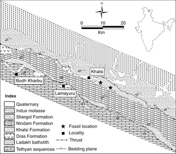
The Ladakh Himalaya, NW India, exhibiting two suture zones (the Shyok Suture Zone [SSZ] and the Indus-Tsangpo Suture Zone [ITSZ]; Srikantia and Razdan, Reference Srikantia and Razdan1980, Reference Srikantia and Razdan1985; Le Fort et al., Reference Le Fort, Tongiorgi and Gaetani1994; Robertson and Degnan, Reference Robertson and Degnan1994; Gaetani, Reference Gaetani1997; Robertson, Reference Robertson, Kahn, Treloar, Searle and Jan2000; Rolland et al., Reference Rolland, Picard, Pecher, Lapierre and Bosch2002; Khan et al., Reference Khan, Walker, Hall, Burke, Shah and Stockli2009; Henderson et al., Reference Henderson, Najman, Parrish, BouDaghar-Fadel and Barford2010), exposes ophiolitic melange, granitic batholith, volcanics, flysch, and molasse sediments. The flysch sequence in the study area is represented by the Khalsi, Nindam, and Shergol formations (Fig. 1). The Khalsi Formation is broadly comprised of Orbitolina-bearing limestone, grayish white limestone, dark gray splintery shale, gritstone, volcanogenic sediment, tuffaceous shale, siltstone, minor quartzarenite along with the ultramafic, serpentinite, and diabase. The thickness of the Orbitolina-bearing limestone bed varies from 5 to 250 m. The limestone bed is highly fossiliferous and preserves rudists (bivalves), gastropods, bryozoans, corals, echinoids, chaetetids, and foraminifera (Srikantia and Razdan, Reference Srikantia and Razdan1980). The siltstone-shale of the Khalsi Formation contains ammonites and belemnites. The limestone was deposited on the shallow water tropical to sub-tropical carbonate platform associated with the Dras volcanic arc system (Van Haver, Reference Van Haver1984; Garzanti and Van Haver, Reference Garzanti and Van Haver1988; Mathur et al., Reference Mathur, Juyal and Kumar2008). The age of the Khalsi Formation is determined based on the foraminiferal (Orbitolina) assemblages. Although a broad age range is envisaged for the Khalsi Formation, the primary investigation carried out by Tewari et al. (Reference Tewari, Pande and Kumar1970) assigned an Aptian age to this formation. Later, Srikantia and Bhargava (Reference Srikantia, Bhargava and Sakalani1978) broadly assigned an Albian–Cenomanian age to the Khalsi Formation. Bassoullet et al. (Reference Bassoullet, Colchen, Juteau, Marcoux, Mascle and Gupta1982), Van Haver (Reference Van Haver1984), and Van Haver et al. (Reference Van Haver, Bassoullet, Blondeau and Mascle1984) suggested an Aptian–Albian age to the limestone exposed near the Khalsi and Tar sections. Cherchi et al. (Reference Cherchi, Gupta and Schroeder1984) constrained the age of the lithological unit to the upper Aptian. Mathur and Vogel (Reference Mathur and Vogel1988) proposed an Aptian to early Albian age to the limestone exposed within the Khalsi Formation. Taking into account all the aforementioned considerations, the Khalsi Formation can be considered as Aptian–Cenomanian in age.
Geological and location map of Khalsi area, Ladakh, India showing locations of Acanthochaetetes.

Materials and methods
Four chaetetid specimens were collected from different horizons of the Khalsi limestone (Fig. 2) in the Khalsi area, Ladakh India. Three chaetetids were recovered mechanically from the limestone, which is highly weathered and fragile. The other one was collected from a broken fragment of the limestone. Two specimens were destroyed during preparation of the thin sections. Eight thin sections were prepared from the four specimens, one longitudinal and one transverse from each specimen for the study of the internal morphology. Thin sections were studied under a microscope (Leica 2700P) at the Petrology Laboratory, Geological Survey of India, Northern Region, Lucknow, India.
Lithological column of Khalsi Formation from where chaetetids have been recovered. Arrows mark Acanthochaetetes-bearing horizons.

Repositories and institutional abbreviations
All the specimens, as well as corresponding thin sections, are kept in a repository of the Geological Survey of India (GSI), Northern Region, Lucknow, India. The holotype is kept in a repository of the Museo de Paleontología de la Facultad de Ciencias (FCMP), Universidad Nacional Autónoma de México (UNAM).
Systematic paleontology
Phylum Porifera Grant, Reference Grant and Todd1836
Class Demospongiae Sollas, Reference Sollas1885
Order Clionaida Morrow and Cárdenas, Reference Morrow and Cárdenas2015
Family Acanthochaetetidae Fischer, Reference Fischer1970
Genus Acanthochaetetes Fischer, Reference Fischer1970
Type species
Acanthochaetetes seunesi Fischer, Reference Fischer1970, p. 201–202, pl. F, figs. 3–5.
Acanthochaetetes huauclillensis Sánchez-Beristain and García-Barrera in Sánchez-Beristain, García-Barrera, and Moreno-Bedmar, Reference Sánchez-Beristain, García-Barrera and Moreno-Bedmar2019
Figures 3–5
Holotype
Whole specimen (FCMP 12/378) with its two corresponding thin sections (one longitudinal and one cross-section) from the San Isidro Formation, Oaxaca state, southern Mexico (Sánchez-Beristain et al., Reference Sánchez-Beristain, García-Barrera and Moreno-Bedmar2019, p. 228–233, figs. 6–8).
Occurrence
Lower Cretaceous (upper Hauterivian–lower Barremian) to Upper Cretaceous (this study).
Description
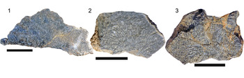
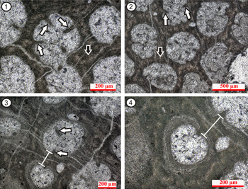
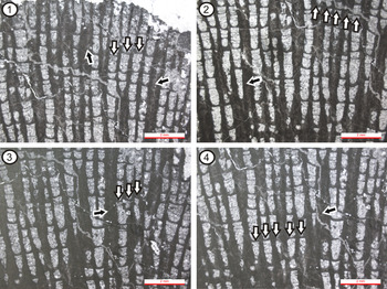
Acanthochaetetid sponges with globular to encrusting form (Fig. 3) and a homogeneous (micritic?) microstructure (Fig. 4.1, 4.2). Spines cover the interior walls of calicles (Fig. 4.1–4.3). Occasionally, tubular thickenings accompany tabulae (Fig. 4.3, 4.4). The characteristic scalariform pattern formed by tabulae in adjacent calicles is frequently found (Fig. 5). Calicle multiplication takes place by both intraparietal gemmation (Fig. 4.2) and, less frequently, by fissiparous division (Fig. 4.1).
Acanthochaetetes huauclillensis, Khalsi Formation. (1) Hand specimen showing well-preserved low domical growth form (destroyed during the preparation of thin sections); (2, 3) hand specimens showing high domical growth form (GSI-NRF-2/517, GSI-NRF-2/518). All scale bars 2 cm.

Photomicrographs of A. huauclillensis in transverse section (GSI-NRF-2/520). (1, 2) Note spines inside calicle lumen (white arrows) and the micritic? microstructure (black arrows); (3, 4) tubular thickenings accompanying tabulae (line segments) and spines (white arrows). See text for further details.

Primary skeleton
No hint of the primary (spicular) skeleton was found. The extent of silicification furthermore hinders any staining technique (i.e., the method of Dickson, Reference Dickson1965), which would allow recognition of spicule remains (Reitner, Reference Reitner1992).
External characters
The basal skeleton is built by calicles, which are separated between each other by a wall (a typical chaetetid structure).
Internal characters
Calicles are oval to round to elliptical (Fig. 4). Division by both fissiparous and intraparietal gemmation can be seen.
Number of calicles per square mm varies from 3–4, usually only 3. Calicle center-to-center diameter measures on average 0.6 mm. Calicle diameter is ~0.45 mm. However, tubular thickenings may be present (Figs. 4.3, 4.4, 5), in which case the calicle diameter value decreases to 0.2 mm.
Photomicrographs of A. huauclillensis in longitudinal section (GSI-NRF-2/519), showing tabulae within each calicle. (1–4) Note the diagnostic scalariform (stair-like) disposition of tabulae in adjacent calicles (white arrows) as well as multiple calicle thickenings (black arrows). See text for further information.

Double-wall thickness values vary between 0.2–0.35 mm. These values are high among chaetetids (Fischer, Reference Fischer1970; Cuif and Fischer, Reference Cuif and Fischer1974; Sánchez-Beristain et al., Reference Sánchez-Beristain, García-Barrera and Torres-Hernández2012, Reference Sánchez-Beristain, García-Barrera and Moreno-Bedmar2019), which are ~0.25 mm.
Tabulae are present within each calicle (Fig. 5). In extant sponges, they separate living tissue and the secondary skeleton. Tabulae measure on average 20–35 μm. However, this is difficult to measure where there is tubular thickening, which is often the case. Tabulae are seldom concordant between adjacent calicles, and the diagnostic “scalariform” (stair-like) disposition noted by Sánchez-Beristain et al. (Reference Sánchez-Beristain, García-Barrera and Moreno-Bedmar2019) frequently can be seen (Fig. 5). Intertabular spaces range from 300–1000 μm. However, due to tubular thickenings, these spaces tend to disappear.
Remarks
All specimens are strongly affected by silicified (e.g., Butts, Reference Butts2014). Silicification also has been reported for the other A. huauclillensis specimens (Sánchez-Beristain et al., Reference Sánchez-Beristain, García-Barrera and Moreno-Bedmar2019), which hinders studies of their microstructure.
Spirastrella (Acanthochaetetes) seunesi (Fischer) from the Upper Cretaceous, differs by having wide calicles. This is reflected in their density per mm2 (up to 1.5), as well as in the center-to-center diameter (x̄ = 0.9 mm). Despite the similarity of the double-wall thickness between S. (A.) seunesi and A. huauclillensis (x̄ = 0.1 versus 0.25 mm, respectively), the difference in calicle diameter is sufficient to separate both taxa. While spiraster microscleres are known in S. (A.) seunesi, they have not been reported in A. huauclillensis.
Acanthochaetetes ramulosus (Michelin, Reference Michelin1846) is known from the Albian to the Cenomanian. It is defined by its branching morphology (ramulosus = branched), and attained lengths of several decimeters (Fischer, Reference Fischer1970). Acanthochaetetes huauclillensis from the Khalsi Formation displays domical morphology. Furthermore, the calicle/mm2 density in A. ramulosus ranges from 2–4, whereas in A. huauclillensis, calicle/mm2 density varies from 3–4. Acanthochaetetes ramulosus and Spirastrella (Acanthochaetetes) dendroformis Reitner, Reference Reitner, Reitner and Keupp1991, may be synonymous (Sánchez-Beristain et al., Reference Sánchez-Beristain, García-Barrera and Moreno-Bedmar2019). Nevertheless, Reitner (Reference Reitner, Reitner and Keupp1991) did not measure calicles while establishing S. dendroformis as a new species.
Spirastrella (Acanthochaetetes) wellsi is an extant species that lives in cryptic habitats on reefs in the Western Pacific Ocean (Hartman and Goreau, Reference Hartman and Goreau1975). Its secondary calcitic skeleton is made up of contiguous vertical tabulate calicles ornamented within by vertical rows of irregular clumps of spines. It possesses a lamellar microstructure. Calicular lumen can be elliptical, pentagonal, or hexagonal, and its diameter is up to 0.6 mm. Calicular wall width is on average 0.07 mm, a value much smaller than in A. huauclillensis. Furthermore, the average calicle density of S. (A.) wellsi is 8–9/mm2. In contrast, this density is much lower in our specimens (3–4, as reported for A. huauclillensis; Sánchez-Beristain and García-Barrera in Sánchez-Beristain et al., Reference Sánchez-Beristain, García-Barrera and Moreno-Bedmar2019). The spicular skeleton of S. (A.) wellsi consists of tylostyles and spiraster-like microscleres. No spicules were detected in our samples.
Acanthochaetetes sloveniensis Flügel and Ramovš, Reference Flügel and Ramovš1978, is a fossil species from the Cenomanian of Central Slovenia. It can be recognized by its double-wall thickness (0.025–0.1 mm), which is smaller than in A. huauclillensis (0.15–0.35 mm). Unfortunately, only one report exists for this species (see Flügel and Ramovš, Reference Flügel and Ramovš1978).
Acanthochaetetes foroiuliensis (Zuffardi-Comerci, Reference Zuffardi-Comerci1926), from the Oxfordian of Catena del Campio, Italy, is a massive, spheroid fossil chaetetid. Although some measurements of A. foroiuliensis, such as calicle center-to-center and internal calicle diameters are similar to those of A. huauclillensis, the double-wall thickness of the former (0.1 mm) is the half of the latter (x̄ = 0.20 mm). In addition, calicle density in A. foroiuliensis reaches 9/mm2, while calicle density seldom exceeds 5/mm2 in A. huauclillensis. These values in the studied specimens are closer to those from A. huauclillensis.
The absence of spicules in our specimens does not hinder taxonomic identification because all remaining (secondary skeleton) characters, as well as the diagnostic “scalariform” (stair-like) pattern in adjacent calicles (Fig. 5), sustain their affinity.
Paleoecology of Acanthochaetetes huauclillensis from the Khalsi Formation, India
Growth forms of chaetetids are used for reconstruction of paleoenvironments such as water energy condition, water turbulence, and sedimentation rate (James and Bourque, Reference James, Bourque, Walker and James1992; Sánchez-Beristain et al., Reference Sánchez-Beristain, García-Barrera and Torres-Hernández2012, Reference Sánchez-Beristain, García-Barrera and Moreno-Bedmar2019). Chaetetids begin growth by developing a laminar form that can build into larger laminar forms, or may be transformed into domical, bulbous, club-shaped, branching, and irregular forms as growth progresses, at least partly influenced by environmental conditions. Reported growth forms of Acanthochaetetidae are either domical or globous (West, Reference West, Debrenne, Hartman, Kershaw, Kruse and Nestor2015a, Reference West, Debrenne, Hartman, Kershaw, Kruse and Nestorb). The studied A. huauclillensis from the Khalsi Formation exhibit low- to high-domical growth forms. These growth forms could be interpreted as adaptations to an environment with constant sedimentation rates (Kershaw and West, Reference Kershaw and West1991) and/or adaptations to an irregular substrate (West and Kershaw, Reference West, Kershaw, Reitner and Keupp1991; West, Reference West, Debrenne, Hartman, Kershaw, Kruse and Nestor2015b). In addition, acanthochaetetids from the Khalsi area show neither growth interruption nor sediment interdigitations in the margin, which reinforces the assumption that no significant changes in sedimentation occurred while they lived (e.g., Sánchez-Beristain et al., Reference Sánchez-Beristain, García-Barrera and Juárez-Aguilar2021). This is supported also by insignificant to non-existent variations in the spacing of the tabulae within calicles, which in turn would suggest that growth rates were constant.
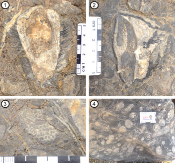
Based on these criteria, a non-turbulent, calm reef or reef-like microenvironment could be proposed for the Khalsi limestone (e.g., Sánchez-Beristain et al., Reference Sánchez-Beristain, García-Barrera and Moreno-Bedmar2019). Similar observations have been reported on Late Cretaceous chaetetids from Central Mexico (Sánchez-Beristain et al., Reference Sánchez-Beristain, García-Barrera and Torres-Hernández2012). Furthermore, the Khalsi Formation, mainly consisting of shale and carbonate, is devoid of any wave or current features. The limestone is thickly bedded with an almost flat top bed geometry. Petrographically, the limestone is dominantly micritic in nature. The obvious absence of major reworking features, as well as the minimum quantity of clastic detritus, justify the interpretation of a very slow rate of sedimentation (Folk, Reference Folk1951). However, the relatively low concentration of fragmentary bioclasts and coarse clasts cannot be completely overlooked. These could be explained by the occasional storm reworking within the shallow platform (Pomar and Kendall, Reference Pomar and Kendall2008). The micritic character of the sediments and the low clastic percentage point towards a relatively calmer and turbulence-free depositional environment for the Khalsi limestone, thus reinforcing the interpretation from chaetetids. In addition, the associated fauna in the Khalsi limestone includes rudists (bivalves), corals (similar to Actinastrea), the gastropod Nerinea (resembling N. texana Roemer, Reference Roemer1852), and foraminifera (Fig 6). Rudists include Eoradiolites gilgitensis (Douvillé, Reference Douvillé1926), Toucasia sp., and ?Horiopleura sp. (Mathur and Vogel, Reference Mathur and Vogel1988). This faunal assemblage points to a tropical to subtropical, shallow marine carbonate platform (Garzanti and Van Haver, Reference Garzanti and Van Haver1988 and Mathur et al., Reference Mathur, Juyal and Kumar2008).
Fauna associated with the A. huauclillensis, Khalsi Formation. (1, 2) Rudist; (3) ?Actinastrea sp.; (4) ?Nerinea texana.

Geographical and stratigraphical distribution of Acanthochaetetes
Although Cretaceous chaetetids have been reported worldwide, they are reported mostly from Europe (Koechlin, Reference Koechlin1947; Schnorf-Steiner, Reference Schnorf-Steiner1963; Fischer, Reference Fischer1970; Kazmierczak, Reference Kazmierczak1979; Reitner and Engeser, Reference Reitner and Engeser1983; Reitner, Reference Reitner, Reitner and Keupp1991, Reference Reitner1992) and some from the Americas (Wells, Reference Wells1944; Sánchez-Beristain et al., Reference Sánchez-Beristain, García-Barrera and Torres-Hernández2012, Reference Sánchez-Beristain, García-Barrera and Moreno-Bedmar2019), as mentioned earlier. The genus Acanthochaetetes has been documented from Oxfordian to Recent. The oldest Acanthochaetetes has been reported from the Oxfordian of the Friuli area, Italy (Zuffardi-Comerci, Reference Zuffardi-Comerci1926; Fischer, Reference Fischer1970). The geographical and biostratigraphical distributions of Acanthochaetetes are summarized in Table 1 and Figure 7.
Occurrence of extant Acanthochaetetes (summarized in Table 1).

Global distribution of Acanthochaetetes of various ages.

Modern acanthochaetetid sponges can produce new individuals by both sexual (Hartman and Goreau, Reference Hartman and Goreau1975; Ruppert et al., Reference Ruppert, Fox and Barnes2004) and asexual (Hartman and Goreau, Reference Hartman and Goreau1975) reproduction. In the former case, Maldonado et al. (Reference Maldonado, Durfort, McCarthy and Young2003), Maldonado (Reference Maldonado2006), and Uriz et al. (Reference Uriz, Turón and Mariani2008) documented that sponge larvae apparently can move with a speed of 3.2 m/5 mins. Acanthochaetetidae can disperse through parenchymella larvae (Ruppert et al., Reference Ruppert, Fox and Barnes2004), which can survive in the water column for as long as 2 weeks. These larvae can be dispersed by wind and waves or by currents (Maldonado, Reference Maldonado2006; Winston, Reference Winston2012). Thus, the distribution pattern indicates that dispersal of Acanthochaetetes larvae may have included the whole Tethys sea, which was covering a vast area during the Early Cretaceous (Hay et al., Reference Hay, DeConto, Wold, Wilson, Voigt, Barrera and Johnson1999; Sánchez-Beristain et al., Reference Sánchez-Beristain, García-Barrera and Moreno-Bedmar2019).
The oldest representative of Acanthochaetetidae is Acanthochaetetes huauclillensis from the upper Hauterivian to lower Barremian in southern Mexico, which is much earlier than the diversification of the Acanthochaetetidae during the Albian in Europe (Sánchez-Beristain et al., Reference Sánchez-Beristain, García-Barrera and Moreno-Bedmar2019). The occurrence of A. huauclillensis in the Khalsi area, Ladakh India (Fig. 8) extends its former stratigraphic range. Thus, the present finding extends the stratigraphic range for this species from the upper Hauterivian to the Cenomanian, and the distribution of the Acanthochaetetidae eastward into Tethyan realms—well into the Neo-Tethys, as defined by Muttoni et al. (Reference Muttoni, Gaetani, Kent, Sciunnach and Angiolini2009), with its main diversification center being in modern-day Europe during the Albian.
Paleogeographic map for 120 Ma showing the reconstructed position of the locality (black star) of Acanthochaetetes huauclillensis from the Khalsi Formation, Ladakh India. The base map was generated using the ODSN Plate Tectonic Reconstruction Service (Hay et al., Reference Hay, DeConto, Wold, Wilson, Voigt, Barrera and Johnson1999, http://www.odsn.de/odsn/services/paleomap/paleomap.html).

Conclusions
The fossil record of chaetetids in India is very scarce, particularly in Ladakh Himalaya. We report Acanthochaetetes huauclillensis Sánchez-Beristain and García-Barrera for the first time from the Khalsi limestone, Ladakh, India. The growth form of acanthochaetetids from the Khalsi limestone suggests a non-turbulent, calm reef or reef-like microenvironment. The micritic composition of the Khalsi limestone, without any primary sedimentary structure and with a relatively clast-free nature, further reinforces the claim of a low energy, shallow marine depositional environment. In addition, the association of chaetetids with reef-dwelling organisms such as rudists, corals, gastropods, and foraminifera also suggests a tropical to subtropical shallow marine carbonate platform setting. Stratigraphically, the present finding of A. huauclillensis extends its range to the Aptian–Cenomanian. In concurrence with the theory of main diversification of the Acanthochaetetidae in modern day Europe during the Albian period (Muttoni et al., Reference Muttoni, Gaetani, Kent, Sciunnach and Angiolini2009), the eastward dispersal of the species during Aptian–Albian time into the Neo-Tethyan realm has been proven.
Acknowledgments
The authors are extremely grateful to the Additional Director General & HOD, Northern region, GSI, the Deputy Director General & RMH-IV, Northern Region, GSI for granting permission to publish the work. The authors also extend their gratitude to A.C. Pande, P. Jana, and A.P. Thapliyal for their constant support and guidance throughout the work. Thanks are also extended to the International Affairs Division, GSI, CHQ-Kolkata for providing necessary permission for the collaborative work. The manuscript was significantly improved by the constructive reviews of S. Kershaw and an anonymous reviewer.