INTRODUCTION
The lakes that occupied the Dead Sea Basin during the Quaternary deposited sequences of evaporite and detrital sediments that contained information on the climatic and tectonic history of the area (e.g. Stein Reference Stein2014 and references there). During the past few decades, there have been extensive studies of the Dead Sea lacustrine deposits on exposed sequences in the marginal terraces and on short cores taken along the lake margins (e.g. Machlus et al. Reference Machlus, Enzel, Goldstein, Marco and Stein2000; Bartov et al. Reference Bartov, Stein, Enzel, Agnon and Reches2002, Reference Bartov, Goldstein, Enzel and Stein2003; Bookman et al. Reference Bookman, Enzel, Agnon and Stein2004; Haase-Schramm et al. Reference Haase-Schramm, Goldstein and Stein2004; Prasad et al. Reference Prasad, Vos, Negendank, Waldmann, Goldstein and Stein2004; Migowski et al. Reference Migowski, Agnon, Bookman, Negendank and Stein2004, Reference Migowski, Stein, Prasad, Negendank and Agnon2006; Torfstein et al. Reference Torfstein, Haase-Schramm, Waldmann, Kolodny and Stein2009, Reference Torfstein, Goldstein, Kagan and Stein2013a, Reference Torfstein, Goldstein, Stein and Enzel2013b; Waldmann et al. Reference Waldmann, Stein, Ariztegui and Starinsky2009). However, the marginal sedimentary records are limited in continuity due to sedimentary breaks and erosion (or hiatuses) during the intervals of low lake stands (e.g. Stein et al. Reference Stein, Torfstein, Gavrieli and Yechieli2010). An objective for drilling a sediment core at the deepest floor of the Dead Sea was to recover a continuous sedimentary record of the late Quaternary and to fill in the gaps in the data and thereby gain knowledge of the climate and tectonics in the Levant region.
During 2010–2011, drilling was carried out at the ICDP 5017-1 site in the northern basin of the Dead Sea (Neugebauer et al. Reference Neugebauer, Brauer, Schwab, Waldmann, Enzel, Kitagawa, Torfstein, Frank, Dulski, Agnon, Ariztegui, Ben-Avraham, Goldstein and Stein2014). The longest core (5017-1-A) was drilled at a water depth of about 300 m, reaching up to 455 m below lake floor (blf) (~750 m below the 2010 Dead Sea lake level; 1175 m below mean sea level) (Stein et al. Reference Stein, Ben-Avraham and Goldstein2011). Another five shorter cores were retrieved from neighboring sites to supplement the long profile (details in Neugebauer et al. Reference Neugebauer, Brauer, Schwab, Waldmann, Enzel, Kitagawa, Torfstein, Frank, Dulski, Agnon, Ariztegui, Ben-Avraham, Goldstein and Stein2014).
Here, we establish the chronological framework of the sediment sequence at the ICDP 5017-1 site during the past 50 ka. This time interval includes the parts of the last Glacial Lisan Formation and the Holocene Ze’elim Formation that were described and studied in the marginal terraces of the Dead Sea and in short cores. The composite profile for the ICDP 5017-1 site (the 5017-1 composite profile) was constructed by combining the long and short cores from five holes. 14C dating was performed on well-preserved and relatively large terrestrial plant remains from the long and short cores.
MATERIALS AND METHODS
Sediment Sampling and Composite Profile at the ICDP 5017-1 Site
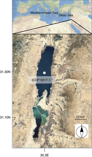
The ICDP 5017-1 site is located in the deepest floor of the northern basin of the Dead Sea (31°30′28.98″N, 35°28′15.60″E, at 297.46 m blf, in November 2010; Figure 1). The drilling at this site was carried out from November 2010 to January 2011 with the Deep Lake Drilling System on a barge (24.4×7.3 m) operated by the U.S. Drilling, Observation and Sampling of the Earth’s Continental Crust (DOSECC) consortium. Two coring devices were used to collect different types of sediment: the rotating extended core bit (Alien) for hard salt sediments and the hydraulic piston core tool (HPC) for soft sediments. For the top 150 m of the sediment profile, the length of each sampling section ranged between 0 and 3.05 m, with an average of 1.90 m. Although the recovery of 5017-1-A is 89.13%, it is less than 70% for the top 80 m blf. Auxiliary short cores were retrieved from neighboring sites (5017-1-B, -C, -D, -E and -H), which fill some of the gaps for the top 80 m blf.
Location of the Dead Sea in the Levant showing the ICDP 5017-1 site

The composite 5017-1 profile is comprised of “muds,” and gypsum, halite, and clastic material. The muds mainly describe laminated sequences of aragonite and silty-detritus laminae (similar to the aad facies described in the marginal terraces, e.g. Machlus et al. Reference Machlus, Enzel, Goldstein, Marco and Stein2000) and laminated detritus (similar to the ld facies described in the marginal terraces, e.g. Haliva-Cohen et al. Reference Haliva-Cohen, Stein, Goldstein, Sandler and Starinsky2012). The aad facies characterizes periods of enhanced freshwater supply to the lake and high lake stands (e.g. the time of deposition of the Lisan Formation), while salt was deposited during the post-glacial and Holocene times, when freshwater supply was low and lake level dropped (see Neugebauer et al. Reference Neugebauer, Brauer, Schwab, Waldmann, Enzel, Kitagawa, Torfstein, Frank, Dulski, Agnon, Ariztegui, Ben-Avraham, Goldstein and Stein2014; Kiro et al. Reference Kiro, Goldstein, Lazar and Stein2015; Torfstein et al. Reference Torfstein, Goldstein, Kushnir, Enzel, Haug and Stein2015). The interval of the Lisan Formation at the ICDP 5017-1 site is disturbed in places by slump sediments. Characteristic marker layers, such as aad sequences, gypsum-aragonite lamina, and gypsum lamina, made it possible to correlate the sediment sections from the different holes at the ICDP 5017-1 site.
In order to obtain the lithologic stratigraphy at the ICDP 5017-1 site, the five short cores (5017-1-B, -C, -D, -E, and -H) were combined to 5017-1-A by correlating 19 well-defined marker layers and 5 facies boundaries recognized in at least two parallel cores (Neugebauer et al. Reference Neugebauer, Brauer, Schwab, Waldmann, Enzel, Kitagawa, Torfstein, Frank, Dulski, Agnon, Ariztegui, Ben-Avraham, Goldstein and Stein2014). Additional marker layers have been included to correlate the sediment sections from the different holes. It is difficult to define rigorous depth of the facies boundary because the lithologic changes are gradual in some cases and the facies boundaries may appear in the uncollected sections (due to incomplete sampling). In this study, we did not use the facies boundary as the marker layers to combine the sediment sections. Of the 56 sections longer than 0.1 m from 5017-1-A, six sections from the 5017-1-A hole (section member 13, 26, 32, 33, 36, and 37) were adjusted in the range from –0.95 m (upward) to 0.43 m (downward) to ensure consistency in the marker layer depths of the 5017 composite profile. The 5017-1 composite profile has been presently generated with well-defined 32 marker layers.
14C Measurement of Terrestrial Plant Remains
We collected nearly 150 samples of organic matter from five cores of the ICDP 5017-1 site (5017-1-A, -B, -C, -E and -H), and carefully screened 54 samples for 14C measurements with the following criteria: >0.5 mg of carbon in sample and their origin. Organic matter of unknown origin, such as small charcoal fragments and cotton-like organic materials (potentially aquatic plants), were excluded for the 14C measurements. 14C measurements of well-preserved and relatively large terrestrial plant remains from five cores have been performed to obtain a robust 14C age-depth relationship extending back to 50 ka BP. In this paper, we summarize 35 new and 19 published 14C data (Neugebauer et al. Reference Neugebauer, Brauer, Schwab, Waldmann, Enzel, Kitagawa, Torfstein, Frank, Dulski, Agnon, Ariztegui, Ben-Avraham, Goldstein and Stein2014, Reference Neugebauer, Brauer, Schwab, Dulski, Frank, Hadzhiivanova, Kitagawa, Litt, Schiebel, Taha and Waldmann2015) from the ICDP 5017-1 site.
The terrestrial plant remains were chemically treated by a standard acid-alkali-acid (AAA) method (Mook and Streurman Reference Mook and Streurman1983). The pretreated samples were combusted in vacuum-sealed quartz tubes with copper oxide, and then CO2 was reduced to graphite by a general hydrogen reduction method using iron catalytic powder. The CO2 of samples collected from sulfur-rich (gypsum) layers were not frequently reduced to graphite by our standard method. To remove sulfur dioxide and other contaminants in the sample CO2 gas, two or three grains of Sulfix (a mixture of silver and tricobalt tetroxide), obtained from Wako Pure Chemical Industries, Ltd., were mixed with copper oxide when the samples were combusted. The CO2 prepared with the treatment can be successfully reduced to graphite for accelerator mass spectrometry (AMS) 14C measurements.
The 14C analyses were performed at three AMS facilities: the Center for Chronological Research at Nagoya University (NUTA2; Nakamura et al. Reference Nakamura, Niu, Oda, Ikeda, Minamia, Takahashi, Adachi, Pals, Gottdang and Suya2000, Reference Nakamura, Niu, Oda, Ikeda, Minami, Ohta and Oda2004), the W.M. Keck Carbon Cycle Accelerator Mass Spectrometry Laboratory (UCIAMS; Southon and Santos Reference Southon and Santos2004; Southon et al. Reference Southon, Santos, Druffel-Rodriguez, Druffel, Trumbore, Xu, Griffin Ali and Mazon2004), and the Korean Institute of Geoscience and Mineral Resources (KGM; Hong et al. Reference Hong, Park, Sung, Woo, Kim, Choi and Kim2010). The 14C ages were calculated from the 14C/12C and 13C/12C ratios determined, including the correction for isotopic fractionation and blank correction (Mook and van der Plicht Reference Mook and van der Plicht1999). For blank correction (including potential contamination during the sample storage, chemical preparation, and AMS 14C measurement), we used a wood piece collected from 343.82 m blf of 5017-1-A (age ~150 ka, Torfstein et al. Reference Torfstein, Goldstein, Kushnir, Enzel, Haug and Stein2015). The wood piece was divided into small chips, and two or three chips were concurrently processed with samples. The 14C dates were calibrated using IntCal13, the Northern Hemisphere atmospheric 14C calibration data set (Reimer et al. Reference Reimer, Bard, Bayliss, Beck, Blackwell, Bronk Ramsey, Buck, Cheng, Edwards, Friedrich, Grootes, Guilderson, Haflidason, Hajdas, Hatté, Heaton, Hoffmann, Hogg, Hughen, Kaiser, Kromer, Manning, Niu, Reimer, Richards, Scott, Southon, Staff, Turney and van der Plicht2013).
Age-Depth Modeling
We adopted a simple method for age-depth modeling using a Monte Carlo simulation. The algorithm of the age-depth model is similar to that introduced by Blaauw (Reference Blaauw2010), also known as the classical model. It consists of the following four steps: (1) sampling from calibrated 14C ages and U-Th age distributions, (2) fitting a smoothed spline curve on age-depth pairs, (3) arranging the fit curves in stratigraphic order (i.e. increasing age with depth below the top of sediment core or decreasing age from the bottom to the top), and (4) using a confidence level of 95.4%. Each step for the age modeling is explained below.
The calibrated age at the 14C-dated depth for the 5017-1 composite profile was estimated based on the probability distribution of calibrated 14C age of terrestrial plant remains and the normal distribution of U-Th age using 8000 retained Markov chain Monte Carlo iterations after removing a burn-in of 2000 iterations. The age-depth relationship between dated depths was deduced to adopt a smoothed cubic spline fit. The smoothing parameters of 8000 smoothed spline fitting curves were determined based on the leave-one-out cross-validation method. We assumed that the estimated model (smoothed spline curve) must be monotonic, i.e. increasing age with depth below the top of sediment core or decreasing age from the bottom to the top. If the slope (change rate) of smoothed cubic spline curve was positive (increased age with depth) for the entire modeled interval, the estimate was recorded to obtain the age-depth model. Finally, the calibrated ages and their confidence level at 95.4% at every individual depth were calculated using the quantile function (Scholz and Hoffmann et al. Reference Scholz and Hoffmann2011), being a nearly similar estimate for the highest posterior density method. The program code for age-depth modeling was written in R (R Development Core Team 2010), an open-source statistical software.
RESULTS AND DISCUSSION
Composite Sediment Profile
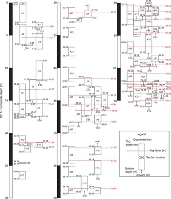
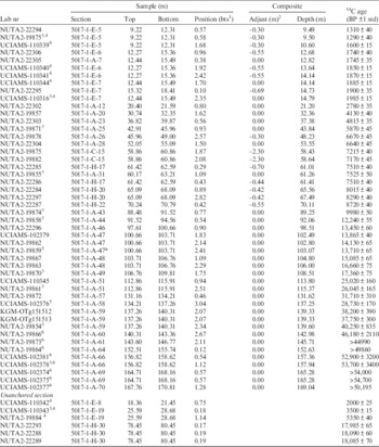
All 14C results are listed in Table 1. A structural diagram for the top 80 m of the 5017-1 composite profile is shown in Figure 2. Presently, 4 of 15 sections from 5017-1-C, 6 of 14 sections from 5017-1-E, and 21 of 28 sections from 5017-1-H were used as anchoring sections. Of all 113 sections of the top 150 m of the sediment, 87 were combined to generate the 5017-1 composite profile.
A structural diagram for the top 80 m of the 5017-1 composite profile from the deepest floor of the Dead Sea (the ICDP 5017-1 site: 31°30′28.98″N, 35°28′15.60″E, 297.46 m below the present lake level). The 87 sections from 5017-1-A, -C, -E, -H were combined to generate the 5017-1 composite profile by anchoring 32 characteristic marker layers (after Neugebauer et al. Reference Neugebauer, Brauer, Schwab, Waldmann, Enzel, Kitagawa, Torfstein, Frank, Dulski, Agnon, Ariztegui, Ben-Avraham, Goldstein and Stein2014). The 5017-1 composite profile from 80 to 150 m blf was established with the sediment sections from a single hole, 5017-1-A (not shown in Figure 1).

14C dates of terrestrial plant remains from the 150-m-long sediment profile at the ICDP 5017-1 site.

1 Distance below the top of sample section.
2 Negative value shows the adjustment to upper (shallow) direction.
3 Neugebauer et al. Reference Neugebauer, Brauer, Schwab, Waldmann, Enzel, Kitagawa, Torfstein, Frank, Dulski, Agnon, Ariztegui, Ben-Avraham, Goldstein and Stein2014.
4 Neugebauer et al. Reference Neugebauer, Brauer, Schwab, Dulski, Frank, Hadzhiivanova, Kitagawa, Litt, Schiebel, Taha and Waldmann2015.
5 Treated as outlier (not used for age-depth model construction).
6 Out of the IntCal13 14C calibration range (not used for age-depth model construction).
There are some discontinuities (gaps) in the top 80 m of the 5017-1 composite profiles due to low sediment recovery over some intervals. The cumulative gaps extend over ~20.33 m (about 25%). Specifically, the continuity for the depths between 23 and 40 m of the 5017-1 composite profile has significant uncertainties. The 5017-1 composite profile for the depths from 76 to 150 m (higher than 90% in recovery) was established with the sediment sections from a single hole, 5017-1-A.
Age-Depth Model Composite Profile at the 5017-1 Site
The integration of 14C data from five cores made it possible to increase the age constraints for the age-depth model of the 5017-1 composite profile. Two data points from 103.07 m and 137.25 m for the 5017-1 composite profile were regarded as outliers based on the assumption of stratigraphic ordering (that is, increasing age with depth). The age depth model of the 5017-1 composite profile was constructed using 39 depth constraints consisting of calibrated 14C ages of terrestrial plant remains and one U-Th age of aragonite (70.51 ka at 174.52 m, Torfstein et al. Reference Torfstein, Goldstein, Kushnir, Enzel, Haug and Stein2015) as a terminal point of the age-depth model calculation over the 14C calibration range.
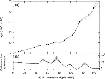
Figure 3 shows the age-depth model of the 5017-1 composite profile at 95.4% confidence level. The age-depth model has uncertainties of <500 yr during the Holocene and roughly 1000 yr during the last glacial period. The uncertain periods provide an acceptable margin (although barely) for assessing synchrony or asynchrony at millennium scales in comparison with better age-constrained records in the East Mediterranean–Levant region, such as the Soreq Cave speleothem record (Bar-Matthews et al. Reference Bar-Matthews, Ayalon, Gilmour, Matthews and Hawkesworth2003), East Mediterranean deep-sea core records (Almogi-Labin et al. Reference Almogi-Labin, Bar-Matthews, Shriki, Kolosovsky, Paterne, Schilman, Ayalon, Aizenshtat and Matthews2009), and global records such as the ice-core chronologies from Greenland and Antarctica (e.g. GRIP Members 1993; Grootes et al. Reference Grootes, Stuiver, White, Johnsen and Jouzel1993; Jouzel et al. Reference Jouzel, Masson-Delmotte, Cattani, Dreyfus, Falourd, Hoffmann, Minster, Nouet, Barnola, Chap-Pellaz, Fischer, Gallet, Johnsen, Leuenberger, Loulergue, Luethi, Oerter, Parrenin, Raisbeck, Raynaud, Schilt, Schwander, Selmo, Souchez, Spahni, Stauffer, Steffensen, Stenni, Stocker, Tison, Werner and Wolff2007; NGRIP Members 2004; Svensson et al. Reference Svensson, Andersen, Bigler, Clausen, Dahl-Jensen, Davies, Johnsen, Muscheler, Parrenin, Rasmussen, Röthlisberger, Seierstad, Steffensen and Vinther2008; EPICA Community Members 2006), marine sediment records (e.g. Bond et al. Reference Bond, Broecker, Johnsen, McManus, Labeyrie, Jouzel and Bonani1993; Hughen et al. Reference Hughen, Overpeck, Peterson and Trumbore1996; Martrat et al. Reference Martrat, Grimalt, Shackleton, de Abreu, Hutterli and Stocker2007), and speleothem and lacustrine varve sediment records in East Asia (e.g. Wang et al. Reference Wang, Cheng, Edwards, An, Wu, Chen and Dorale2001, Reference Wang, Cheng, Edwards, Kong, Shao, Chen, Wu, Jiang, Wang and An2008; Nakagawa et al. Reference Nakagawa, Kitagawa, Yasuda, Tarasov, Nishida, Gotanda and Sawai2003, Reference Nakagawa, Tarasov, Kitagawa, Yasuda and Gotanda2006; Cheng et al. Reference Cheng, Edwards, Broecker, Denton, Kong, Wang, Zhang and Wang2009).
(a) Age-depth model of the 5017-1 composite profile at the interval of 95.4% confidence level. (b) The sedimentation rate calculated from the age-depth model. The gray boxes mark uncertainties at the 95.4% confidence level.

The sedimentation rates were calculated for each meter from the age-depth model using a Monte Carlo simulation method. The sedimentation rate changes significantly at the boundary between the Holocene (~10 mm/yr) and the last glacial periods (~2 mm/yr), and apparent enhancements of the sedimentation rate are estimated around ~50 m blf (~7.5 ka in maximum), 75 m blf (10 ka), 100 m blf (15 ka), and 125 m blf (33 ka). About 20% of the 5017-1 composite profile consists of halite sequences. The enhanced sedimentation rate partly corresponded to the halite deposition during low lake stand intervals. These periods characterized in enhanced sedimentation rate respond to the gaps (hiatus) of the sedimentary records from the exposed sequences in the marginal terraces and short cores taken along the lake margins.
Implications of the Composite Chronology at the 5017-1 Site
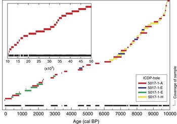
The depositional ages of the 87 anchored sediment sections were calculated from the age-depth model (Figure 4). The median values of the age distributions at 95.4% confidence level for the top and bottom of each section are plotted. It should be noted that the age estimation of each section has some uncertainty due to discontinuous features of the 5017-1 composite profile.
Deposition intervals of the 87 anchored sediment sections of the 5017-1 composite profile calculated using the age-depth model.

The 5017-1 composite profile is highly segmented over the past 6000 yr. It is not suitable for obtaining continuous sediment records. Although there may be short discontinuities, the sedimentary record between 6 and 50 ka seems to be continuously preserved. The 5017-1 composite profile can partly fill the gaps of the sedimentary records from the exposed sequences in the marginal terraces and short cores taken along the lake margins, such as the potential hiatuses between 8.1 and 7.6 ka of Migowski et al. (Reference Migowski, Stein, Prasad, Negendank and Agnon2006), a ~1400-yr-long sedimentary hiatus at the Bølling-Allerød time interval (from 14.6 to 13.2 cal BP) of Stein et al. (Reference Stein, Torfstein, Gavrieli and Yechieli2010) and the 5100-yr-long sedimentary hiatus in the Perazim Valley (PZ1) section between 43.9 and 49 ka (Haase-Schramm et al. Reference Haase-Schramm, Goldstein and Stein2004), as well as in the Masada (M1) section between 39.7 and 31 ka (Torfstein et al. Reference Torfstein, Goldstein, Kagan and Stein2013a). These observations have significant implications. The “filling of the gap” at the Bølling-Allerød time interval implies that the lake was significantly above the deepest floor of the Dead Sea (5017-1 site) at the time, as no salt is found in the core during this time interval. Yet, some of the “gap-filled” intervals in 5017-1-A, for example, the ~39.7- and 31-ka intervals, consist of slump units, which apparently do not disturb the age-depth model.
Towards Achieving a Robust Age-Depth Model Construction
There are still gaps or discontinuities in the 5017-1 composite profile due to low sediment recovery, especially at 50 m blf. Combining the uncorrelated 26 sediment sections of all 113 sections of the top 150-m-long sediment sequence would help to fill the gaps in the 5017-1 composite profile. A detailed comparison of high-resolution magnetic susceptibility and μXRF scanning element (Si, S, Cl, K, Ca, Ti, Fe, and Sr) profiles, as well as additional measurements of the aragonite U-Th ages, may help to reduce the gaps in the 5017-1 composite profile.
The enhanced sedimentation rates generally correspond to the halite deposition. To obtain a more robust chronology of the 5017-1 composite profile, the construction of a deposition model including lithological information such as lithofacies and turbidite layers is desirable. Sequences with annual lamination have been recognized in the Upper Member of the Lisan Formation of the last glacial Lake Lisan and the Holocene Dead Sea (Heim et al. Reference Heim, Nowaczyk and Negendank1997; Prasad et al. Reference Prasad, Vos, Negendank, Waldmann, Goldstein and Stein2004). Such lamination was also observed in some intervals of the 5017-1 composite profile (Neugebauer et al. Reference Neugebauer, Brauer, Schwab, Dulski, Frank, Hadzhiivanova, Kitagawa, Litt, Schiebel, Taha and Waldmann2015). Future study of laminations may provide independent chronological constraints for improving the age-depth model of the 5017-1 composite profile.
CONCLUSIONS
This study resulted in a preliminary chronological framework for the 50,000-yr-long sediment record that was recovered by drilling at the deepest floor of the Dead Sea north basin. Although an in-depth discussion on sediment continuity and the limitation of age-depth model is still necessary, this chronology reinforces a large variety of results from the exposed sequences of the Dead Sea lacustrine deposits and short cores from the lake margin, and offers a remarkable and potential archive for study of the paleoclimate, tectonics, paleoseismology, paleomagnetism, and human history for the Levant region.
Acknowledgments
We acknowledge the International Continental Scientific Drilling Foundation (ICDP), Israel Science Foundation (ISF), US NSF (grant EAR 11-15312 to SLG and Emi Ito) for funding the coring, and DOSECC (Drilling, Observation and Sampling of the Earth’s Continental Crust) for performing the drilling operation. The cores were opened and described by a large team under the auspices of the A Brauer, Markus J Schwab, and I Neugebauer at GFZ-Potsdam. We also wish to thank the many participants who took part in the drilling operations, core opening, and sampling. The complete list of scientists involved in the Dead Sea Deep Drilling Project can be found at http://www.icdp-online.org. The scientific study is partly supported by a Grant-in-Aid for Scientific Research from The Japan Society for the Promotion of Science (grant #25241007, #16H06410 to HK) and by the Excellence Center grant of the Israel Science Foundation (ISF) grant 1736/11 to B.L. (The Dead Sea Deep Drilling Project: The Dead Sea a Global Late Quaternary Paleo-Environmental, Tectonic, and Seismological Archive).