CONQUEST-PERIOD CITY-STATES AND EMPIRES
Ethnohistoric sources provide scholars with rich information on Mesoamerican polities at the time of the Spanish conquest. A long tradition of research, following the “direct historical approach,” attempts to determine whether polities of the sort documented in the ethnohistoric sources existed in earlier periods. Did Teotihuacan or Monte Albán rule domains like the Aztec empire? Did sixteenth-century Maya institutions like the batabil exist in the Classic period? Was the Aztec altepetl (city-state) system present in earlier periods (Hirth 2003a; Zeitlin 1990)? While drawing comparisons between historic descriptions and archaeological data can be a valuable and productive approach, archaeologists must be wary of giving too much literal credibility to the written sources, nearly all of which are propagandistic and biased. It is equally important to consider changes that took place immediately preceding and in association with Spanish contact. In this section we review briefly the variation in political forms at the time of Spanish conquest; some of the limitations of the documentary sources for the study of Mesoamerican political dynamics are discussed in a separate section below.
The Triple Alliance or Aztec Empire (composed of Tenochtitlan, Texcoco, and Tlacopan) is the best known ancient Mesoamerican polity. The conquering and governing Spaniards had considerable interest in determining how this tribute-generating entity worked, and the empire is documented in a wide range of written sources. Ross Hassig (1985) first identified the structure of the Aztec empire as “hegemonic” in nature (employing indirect control of provinces, in contrast to the direct control of “territorial” empires), thereby helping place the polity in a comparative perspective. Most conquered polities were left to their own devices as long as they paid tribute to the imperial capitals.
The specific strategies and processes of indirect rule were examined by Berdan et al. (1996), who used local documents from provincial areas to identify two geospatial patterns: (1) an inner core of provinces that made regular tribute payments (as listed in documents such as part 2 of the Codex Mendoza [Berdan and Anawalt 1992]); and (2) a group of outer client states that maintained imperial frontiers and provided “gifts,” but not “tribute,” to the capitals. Pedro Carrasco (1999) analyzed documents from the three imperial capitals to show how they established and maintained a complex and cross-cutting system of tribute, authority, and territory. More recently, archaeology has become the major source for new insights on the Aztec empire and imperial processes. In Tenochtitlan, the Templo Mayor project has uncovered dramatic evidence of political ceremony at the heart of the empire (López Luján 2006) and recent fieldwork in the provinces has illuminated the impact of Aztec imperialism on the ground (Ohnersorgen 2006; Smith and Berdan 2003; Sergheraert 2009).
The Aztec empire was constructed on a foundation of city-states, and these polities were far more important in the lives of most of the Aztec peoples than was the empire. As in the case of the empire, our understanding of Aztec city-states began with documentary research (Gibson 1964; Lockhart 1992) and is continuing with archaeological fieldwork (Hodge 1997; Smith 2008a). As in other city-state systems around the world (Hansen 2000), central Mexico was a politically fragmented, but culturally unified, landscape. Individual city-states warred and competed with one another, while simultaneously interacting peacefully through trade, noble intermarriage, and visiting. Rulers of these polities (altepetl in Nahuatl) were selected by a council of nobles from the royal lineage. The small size of the Aztec altepetl is notable; the typical Aztec polity controlled approximately 90 km2 of territory. Within a given altepetl, the capital city was the only urban settlement. The median population of second-largest settlements was only 7% of the population of the capital and very few second-order sites contain any public architecture (Smith 2008a:152). Small polities were the norm in Conquest-era Mesoamerica (Smith and Berdan 2003).
In the Maya area Contact-period materials are less numerous and detailed than those available for central Mexico. Furthermore, archaeologists are frequently drawn to accessible accounts that are not firsthand and/or have the potential to incorporate misinformation. Bishop Landa's Relación de las cosas de Yucatán (Tozzer 1941), for example, may well include plagiarism from other sources and areas (Chase 1986; Restall and Chuchiak 2002). Nevertheless, studies of these documents suggest the existence of a variety of Contact-period political forms. Roys (1957) identified three different kinds of political organization within the pre-contact regional states of the Northern Lowlands. His first type represented centralized control of a polity through a single individual, a halach uinic, under whom a series of batabil was organized. In his second type, extended kin relations produced a series of interrelated batabil who collectively governed the polity. His third type consisted of loosely allied batabil who did not share kinship affiliations and who were largely independent of each other, probably only coalescing in times of crisis. Restall (1997:7) has further noted that each batabil was in charge of a cah, which he identified as the principal sociopolitical unit of the Maya and as equivalent to the central Mexican altepetl. Restall (1997:28) also commented that the kinship alliances noted by Roys were probably based on patronym groups, called chibal, which he equated with “a capolli-type subunit.”
Archaeological and ethnohistoric data have been used to suggest that a Postclassic period Maya hegemonic empire was centered at the site of Mayapan (Pollock et al. 1962). Ethnohistoric sources record a form of government at Mayapan (and also perhaps at the earlier Chichen Itza; see Cobos 2007) called multepal that implied a “joint rule” of other dominated polities. These same sources record that Mayapan's demise about a.d. 1440 resulted in the fragmented political picture recorded for the Contact-era Northern Lowlands (Roys 1957). For the Postclassic Guatemalan Highlands, a series of smaller city-states (Smith 1955) resembles the situation described for central Mexico by Smith (2008a).
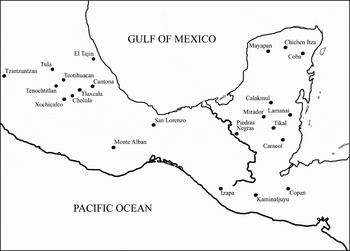
Not all regions of Mesoamerica (Figure 1), however, were organized into small polities at the time of Spanish conquest. The Tarascan empire, centered on the site of Tzintzuntzan, developed at the same time as its Aztec rival, and the two expansionist polities achieved a military standoff several decades prior to the Spanish conquest. The Tarascan domain is largely ignored in the standard central Mexican ethnohistoric sources, perhaps because of Mexica embarrassment at their lack of military success. The available documentary and archaeological data on the Tarascan empire show that it had a more centralized and “territorial” structure than the Triple Alliance empire (Pollard 1993). The Tarascan kings were powerful figures, and their regional economy was under greater administrative control than in Aztec central Mexico.
Map of Mesoamerica showing location of larger sites discussed in the text.

MAYA STATES
Our knowledge of Classic period Maya states comes from both historic and archaeological sources. Hieroglyphic texts record key Maya events on stone, stucco, and portable artifacts that can be combined and contrasted with settlement and excavation data to make interpretations about Classic Maya political organization. Much as Spanish accounts of Contact-period Mesoamerica must be carefully evaluated, so too must Classic Maya hieroglyphic texts be placed into archaeological context. Not only were these texts limited in their content, focusing primarily on commemorative events related to the ruling elite (Clancy 2009), but they also contained intentional religious (Stuart 2005) and political (Marcus 1992) propaganda.
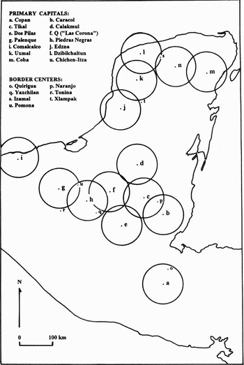
For the Preclassic era (pre-a.d. 250) few texts exist, yet precocious political developments are in evidence at both Izapa and Kaminaljuyu in the Guatemalan Highlands and for a series of sites in the Southern Lowlands that include Lamanai, Tikal, Mirador, and Nakbe (among many others). It is likely that many Maya sites functioned as city-states by the Late Preclassic period. There has also been some discussion over whether or not El Mirador was in control of a regional state in the Late Preclassic era, largely based on its spatial extent and on the dating of its causeway system to this era (Dahlin 1982). By the Early Classic period (a.d. 250–a.d. 550), most of the Maya area comprised a series of definable polities (Mathews 1985) and by the Late Classic period (a.d. 550–800) over a dozen large metropolitan areas are in evidence (see Figure 2). The causeway system at Coba indicates that this polity formed one of the largest of these regional states, with one road extending 101 km west to the site of Yaxuna (Shaw 2008).
Map of the Maya Lowlands showing the locations of 14 proposed primary capitals and seven border centers relative to the maximal marching area for territorial control by each of these capitals; these heuristic circles (not representative of the actual polity) are also useful for understanding conflict both within and between polities (after Chase and Chase 1998:15).

Modern views of Classic period Maya political structure are conditioned both by the incomplete and potentially biased hieroglyphic record and by the currently excavated sample of archaeological sites. Nevertheless, these data suggest that polities of varied sizes and degrees of centralization existed in the Maya area during the Classic period. Late Classic period Caracol and Chichen Itza represent one extreme—large capital cities situated within regional states; in contrast, sites such as Piedras Negras and Copan may represent the seats of smaller political units. Regardless of their size, the impact of cities and states was felt beyond their immediate borders. As was the case throughout ancient Mesoamerica, a system of hegemonic control left remnant tentacles embedded in areas located at some distance from capital cities. This impact is particularly noticeable in emblem glyph distributions (Marcus 1976) but is also evident in considerations of portable artifacts.
The archaeological data also demonstrate that significant differences existed in the socio-political structure between sites located in the Northern and Southern Lowlands, as can be seen in architectural styles and site organization (Chase and Chase 1992). Few Late Classic period sites in the Northern Lowlands exhibit a focus on epigraphic texts associated with stelae and altars. Thus, historical reconstructions based on epigraphy focus mainly on the Southern Lowlands. But epigraphic interpretations alone may be misleading. Without epigraphy, any Classic period Maya “empire” is difficult to envision and alternative sociopolitical models are possible. For instance, at Caracol, dynastic rulers are almost invisible in the archaeological record during the Late Classic period. During the time that the hieroglyphic record is silent, there is evidence for tremendous growth, prosperity, and stability at Caracol (Chase and Chase 2003). It has been suggested, therefore, that the Late Classic period political leadership of Caracol was more bureaucratic, focusing on management strategies that revolved around an administered economy and symbolic egalitarianism, strategies very different from those traditionally associated with dynastic rulership (Chase and Chase 2009; Chase and Chase 2006).
There has been considerable discussion of Classic Maya polity size—much of it based on interpretations of hieroglyphic material. Some scholars (Mathews 1985, 1991; Schele and Mathews 1991) have characterized all Maya polities as city-states, suggesting that each site with an emblem glyph was a distinct political entity. Others (Martin and Grube 1995, 2000) have proposed that two Maya “super-states,” Calakmul and Tikal, controlled the Classic period Southern Lowlands. Our own view is somewhat intermediate, coinciding better with other archaeological delineations of Maya regional states (Adams and Jones 1981). We believe that the optimal area of territory that could be directly controlled was proportional to the distance that could be effectively defended in a three-day march (Chase and Chase 1998:17) based on considerations of marching distance and provisioning outlined by Ross Hassig (1988, 1992a, 1992b). This area is relatively small by today's standards, consisting of a 60-km radius (ca. 11,000 km2). However, it matches well with ethnohistoric descriptions of the sizes of Conquest period “provinces” (i.e., polities) (Roys 1957). In a paper on polity size (Chase and Chase 1998), we correlated a “60 kilometer rule” with hieroglyphic descriptions of aggression (Figure 2). The linear distances between warring emblem glyph sites fall between 24 and 153 km (Chase and Chase 1998: Table 1) with a median distance of 63 km. Most of these battles are seen as territorial in nature, occurring when independent polities developed within the easily defendable radius of neighboring groups. Border centers between polities are generally found 30 to 60 km distant from a primate capital city and sometimes extended marching range for more direct control. Because of its proximity to Tikal, Naranjo, located 42 km from Caracol and 40 km from Tikal, was the locus of repeated aggression by Caracol. The incorporation of Naranjo into a Caracol regional state for almost 50 years meant that Caracol could effectively control Tikal for this same period of time. Any warfare and/or direct control beyond the 60 km range would have been more difficult to maintain. Thus, Maya polities likely maintained hegemonic control over areas outside these limits.
The Terminal Classic period (a.d. 800–a.d. 900/950) has been associated with the “collapse” of Southern Lowland Maya polities and correlated with a cessation in the public display of textual records. This time has generally been described as the disintegration of Maya political structure and interregional contact. However, the archaeological data contradict this traditional model. Many Maya sites prosper past the disappearance of their epigraphic records and show evidence of long-distance trade in prestige goods through the time of their final abandonment (Chase and Chase 2006; Harrison 1999). Chichen Itza clearly prospers at precisely this time (Cobos 2004), and it may be that this site was the seat of a hegemonic empire extending throughout much of the Maya Lowlands at approximately a.d. 900 (A.F. Chase and Chase 2004) and was possibly associated with a corresponding spread of new religious symbolism (Ringle et al. 1998).
OTHER MESOAMERICAN STATES
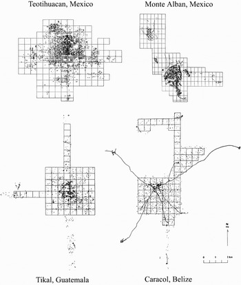
Many large Mesoamerican cities (Figure 3) served as political capitals at some point in their histories, and the nature of their political structure and dynamics have been active topics of research. Although the roster of relatively well-documented Mesoamerican states is rapidly increasing with more fieldwork and ancillary research, space limitations force us to include only a few such polities in this section: Teotihuacan, Monte Albán, Tula, and Olmec polities.
Comparative sizes of Mesoamerican urban areas, all to the same scale.

Teotihuacan
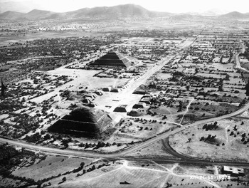
As one of the largest Mesoamerican cities and with probably the most centrally planned layout (Figure 4), many authorities have hypothesized a strong central government for Teotihuacan. In contrast to the contemporaneous Classic period Maya cities, however, the art and architecture of Teotihuacan provide little concrete evidence for rulership. There are no clear representations of rulers and no obvious royal palace or royal tombs (Cowgill 2008); Sanders and Evans (2006), however, do point out several likely candidates for a palace. The strong contrast between the political dynamics of Teotihuacan and the Classic Maya cities have been incorporated into Blanton et al.'s (1996) influential “dual processual” model as a distinction between corporate polities—more egalitarian with shared governance and less emphasis on individual rulers—and network or exclusionary polities—characterized by strong rulers with cults of personality. In Blanton and Fargher's (2008) model of collective action theory, Teotihuacan (like other “corporate” polities) would probably score high on their measures of collective action, such as the provision of public goods, bureaucratization, internal revenue sources, and societal control on rulers.
Photograph of central Teotihuacan, Mexico (photograph courtesy of Compañía Mexicana de Aerofoto, reproduced with permission).

Two major studies by art historians (Headrick 2007; Pasztory 1997) interpret aspects of governance and society at Teotihuacan on the basis of images. While these works contain some useful insights, they tend to rely on heavily speculative argumentation. Excavations of likely district administrative centers within the city suggest a strong governmental presence in the residential zones (Cabrera Castro 2002; Manzanilla 2002). Smith and Montiel (2001) present a material-culture model of Mesoamerican imperialism and argue that the data support the notion that Teotihaucan ruled an empire of some 20,500 km2 in central Mexico. In fact, it is unlikely that Teotihuacan's direct influence extended very far beyond the Valley of Mexico; its southern neighbor, Cholula, likely remained an independent polity throughout its long history (McCafferty 2007; Millon 1988). Teotihuacan's imperial control almost certainly did not extend into the Maya Lowlands. Some other, non-imperial explanation must be found for Teotihuacan contacts in the latter area (Braswell 2003).
Monte Albán
The Classic period Zapotec state centered on Monte Albán has seen considerable research focused on political dynamics. Texts in the partially deciphered Zapotec script have been interpreted as signaling powerful rulers in control of a polity more similar to the Maya than to Teotihuacan (Marcus 1992). The carefully planned urban epicenter and monumental architecture—including a large royal palace, the “North Platform”—support this interpretation. Dramatic archaeological evidence for Zapotec conquest and destruction in the Cuicatlan region (Redmond 1983) suggests the presence of an expansionist empire in the Monte Albán II period, although the reality of Zapotec imperial conquests on the Pacific Coast has been hotly debated (Joyce 2003, Zeitlin and Joyce 1999). Published maps vary greatly in estimating the extent of the Zapotec polity, ranging from a high of 40,000 km2 (Marcus and Flannery 1996:207) to a more likely size of between 6,100 to 16,200 km2 (Spencer 2007:1); Zeitlin and Joyce (1999) would probably model the polity at this latter size or even smaller.
Tula
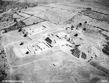
The size and architectural richness of the Early Postclassic period city of Tula (Figure 5) suggests the presence of strong rulers (Mastache et al. 2002), although the epigraphic record of the city is ambiguous in this respect (Kristan-Graham 1999). Instead of searching for direct evidence of administrative structure and political dynamics, most scholars have been content to accept Aztec legends about the Toltec polity as historically accurate. For their own ideological reasons, the Aztecs considered it advantageous to portray Tula (Tollan) as the capital of a large and powerful empire. Smith and Montiel (2001) criticize this approach and argue that the archaeological evidence is inconsistent with such a polity. It is more likely that Tula was a powerful regional state with control over few, if any, areas outside of its immediate region; reconstruction shows a likely territory size of 8,000 km2.
Photograph of central Tula, Hildago, Mexico (photograph courtesy of Compañía Mexicana de Aerofoto, reproduced with permission).

Olmec polities
Arguably the earliest complex polities in ancient Mesoamerica, those of the Olmecs have been variously positioned in terms of their sociopolitical complexity (Pool 2007:19–22). Originally conceived of as states (Coe and Koontz 2002; Heizer 1960) or even empires (Bernal 1969; Caso 1965), Sanders and Price (1968) repositioned the Olmec polities as chiefdoms, a view subsequently adopted by other researchers (Sharer and Grove 1989). Flannery (1998) argued that the Olmecs could not be classified as a state-level society because they lacked rulers' palaces, standardized temples, and royal tombs. Against this view, Cyphers (1997e) points to the existence of elaborate monuments, craft specialization, elite residences, and a hierarchical settlement pattern at San Lorenzo as evidence that the early Olmecs were in fact organized as a state-level society, a view also espoused by Clark (2007). Following Sanders (1970:441), we would agree that “whether one calls the Early and Middle Formative period polities chiefdoms or states is a rather academic point at best.”
The nature and extent of Olmec political, cultural, and economic influence outside of their Gulf Coast home has proven to be one of the most contentious issues in recent Mesoamerican archaeology, with a lengthy published debate among scores of archaeologists (Neff 2006; Sharer 2007). As outsiders, we do not yet see much headway in our understanding of Olmec political dynamics.
THE RELATIONSHIP OF ARCHAEOLOGICAL AND HISTORICAL DATA
The written record has been heavily used in reconstructing Mesoamerican political organization. Much of the content of Mesoamerican writing is political in orientation, and the life histories and deeds of rulers are major themes in Maya inscriptions, in Aztec and Mixtec codices, and in native historical accounts told to the Spaniards after the conquest. While no one can deny the value of such sources for the study of ancient political dynamics, they must be used with caution. Many of the texts were recorded and displayed for overt political purposes, and their propagandistic content is manifest. Some scholars have an unfortunate tendency to view the written record as “superior” to the archaeological record as a source of information on ancient complex societies (see discussion in Moreland 2006). One consequence is that the role of archaeology is sometimes seen as simply filling in the gaps or augmenting historical reconstructions, and another is that historical evidence is preferred over archaeological data when the two sources seem to contradict one another.
Aztec political dynamics furnish several examples of the biases of written political texts and problems that arise when they are given too much credibility. From Aztec native historical accounts of the Tarascan empire, one would have no idea that there might be commerce or interaction across the fortified Aztec-Tarascan frontier. These were portrayed as completely hostile polities with virtually no interaction after a series of battles in the 1470s. Archaeologists seemed to accept this position until evidence started to appear in the 1980s that Tarascan obsidian is found at Aztec sites and that Aztec obsidian occurs within the Tarascan domain (Pollard and Smith 2003). Interestingly, the first author to propose “unofficial” cross-border trade between the Aztecs and Tarascans was novelist Gary Jennings, in his 1980 novel, Aztec (Smith 2001a).
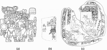
Much of the official state art of Tenochtitlan was so heavily propagandistic in nature that it cannot be trusted as “historical” narrative (Umberger 2007). For example, the Mexica emperor Tizoc had himself portrayed as vanquishing the king of Tlatelolco (Figure 6a), whereas in fact that conquest had been carried out by his predecessor, Axayacatl. In a similar vein, the so-called “flowery wars” (xochiyayotl) between the Aztecs and Tlaxcala provides another example of propagandistic lies in the Aztec sources that have been accepted by scholars insufficiently critical of the political nature of such discourse. In spite of decades of effort, the Aztec armies could not manage to conquer the hostile polities of Tlaxcala. When asked about this by the Spaniards, Aztec nobles replied that they did not really want to defeat the Tlaxcalans. They could do this easily whenever they wanted, but they preferred to have an enemy close by so that Aztec soldiers had a chance to engage in practice battles (the flowery wars). When the Spaniards asked the Tlaxcalans about these wars, however, they got a different story. Their version was that the Aztecs were trying very hard indeed to conquer Tlaxcala and that by 1519 they had almost succeeded: the state was surrounded, its external trade cut off, and its armies close to defeat. The puzzling aspect of the “official” Aztec version of the “flowery wars” lies more in its acceptance by modern scholars as historical fact than in its promulgation by Aztec nobles as a face-saving attempt to cover an embarrassing fact (for discussion and documentation see Smith 2003a:171, 307, n.23). Widespread acceptance by scholars of Aztec legends about the Toltec empire is another example of an overly credulous attitude toward the historical validity of indigenous political narratives (Smith 2007b; Smith and Montiel 2001).
Classic Maya inscriptions are similarly problematic. Once taken to be literal history by most epigraphers (Martin and Grube 2000), recent readings have found texts to be infused with references to Maya cosmology, mythology, and religion (Stuart 2005) as well as political propaganda (Marcus 1992). Importantly, from the standpoint of this paper, epigraphic texts have been used to argue for the incorporation of Maya states into two larger “super-states,” centered at Tikal (mutul emblem) and Calakmul (snake emblem) during the Classic period (Martin and Grube 1995, 2000). Yet, this model can be contested—not only by archaeological data but also even more crucially by revisions to epigraphic interpretation. The identification of a super-state snake polity is based on the distribution of the snake emblem glyph at multiple sites through the Southern Maya Lowlands. The presumption that Calakmul was the political capital for this empire is based on a similarity in named individuals at a wide range of sites and on the use of mythological place names. Newer epigraphic readings show that Calakmul used a bat emblem rather than the snake emblem during the Late Classic period (Martin 2005) and that multiple animal icons are conflated as the snake emblem (Harrison 2008). When combined with the fact that Calakmul had named rulers other than those traditionally associated with the snake emblem at other Maya sites (Marcus 1987), the placement of Calakmul as the capital of the snake polity is open to question. One alternative denies the predominantly political context to the snake emblem and sees it as a title associated with religious individuals involved in leadership succession (Savage 2007). Likewise, literal interpretations of Maya aggression as reflecting personal relationships among named and iconographically portrayed personages ignore the possibility that some individuals recorded and depicted on Classic period monuments may represent not individual rulers but rather the body politic. Thus, while the captive “K'inichil Kab” can be conceived to be a living personage (Martin and Grube 2000:77) portrayed and written about on Naranjo Stelae 22 and 24, this “name” may also be translated as “the western land” (Marcus 1992:412), instead emphasizing conquest and subjugation. Literal content cannot be assumed for Maya hieroglyphs; their meanings need to be fully contextualized (Chase et al. 2008).
The written records of ancient Mesoamerica will continue to constitute a primary resource for understanding their past political organization. Yet, the overt recognition of the political nature of the texts, iconography, and public architecture is key for further analysis.
PRINCIPLES AND DYNAMICS OF MESOAMERICAN POLITIES
The archaeological identification of states and empires in Mesoamerica is not a simple process. While large concentrations of monumental architecture and carved sculpture may aid in recognizing significant centers, the relationships of these centers to their hinterland and to other sites is often difficult to establish. Mesoamerican archaeology demonstrates great variability in architecture, art styles, and ceramics. In the Maya area, hieroglyphic texts have been used to make political inferences, but many other parts of Mesoamerica do not have the advantage of this luxury, although codices and ethnohistoric references are used to examine Aztec, Mixtec, and Zapotec hegemonies. Mesoamericanists have tended to identify most major centers as being “city-states” for two reasons: first, it is difficult to see (and distinguish) alliances, hierarchies, and hegemonies in the archaeological record; and, second, most archaeologists are site-focused, even when carrying out survey. Thus, we have a tendency to split the ancient landscape into discrete units. Although some Mesoamerican regions, such as Aztec central Mexico, fit Hansen's comparative model of city-state cultures rather closely (Hansen 2000; Smith 2000), this model provides a much looser fit for regions such as the Classic period Maya Lowlands (Grube 2000). Maya polities were larger in size (by almost two orders of magnitude), with more complex administrative and urban hierarchies, than the Aztec altepetl. While on a very general level both could be categorized as city-state systems, we should not let this mask the significant variation that existed among systems of polities in ancient Mesoamerica.
Polities were not defined by territory
One of the interesting features of Mesoamerican polities in comparative perspective is that the spatial extent and membership in a state generally were defined not on the basis of land or territory, but on the basis of personal ties to a ruler. This pattern is clearest for Aztec city-states, where Gibson (1964:44–47) published the first evidence that rural hamlets subject to adjacent Aztec altepetl capitals were interspersed in such a way that it is impossible to draw intact territory boundaries between nearby altepetl (for an updated discussion, see Smith 2008a:Chapter 3). Several recent analyses of Classic period Maya city-states take a similar position (e.g., Grube 2000), arguing that Maya polities were defined by personal relationships with the ruler and not by territory. Houston (2006:205), for example, suggests that “the Maya community at the polity level had a strong characteristic of a centripetal organization focused on the rulership rather than of a corporate group with clear boundaries.”
This focus on rulers, however, should not be confused with simpler forms of political organization. The ruler was a representation of the “body politic” (Kantorowicz 1997). Dynastic rulership may not have been as omnipresent as is often suggested. At least in highland Mexico, and probably elsewhere in Mesoamerica, the rulers were selected by councils and did not form a patrilineal dynastic line. Restall (1997:65) suggests that Postclassic period Maya rulership also was probably not dynastic, noting that individual leaders served only 20-year terms in the Contact period batabil organization. The odd 20-year patterning of Terminal Classic period rulers found at Caracol, Belize (Chase et al. 1991) suggests that such a system also was in operation at the end of the Classic period.
All Mesoamerican polities were composed of various segments, but none were segmentary states. Archaeological data indicates that a wide variety of governing strategies were employed in these polities; some were more collective and heterarchical in their organization while others were more hierarchical and centralized. And, while most Mesoamerican polities may have been centered about the ruling elite, this elite was concerned with borders and territory when they related to needed resources. Golden and colleagues (2008) demonstrated how political interactions between two Maya polities could create a boundary. Andrews (1984) has documented extensive territorial disputes over salt areas in the Northern Maya Lowlands. However, territory in and of itself was not the basis for polity identification or identity.
These discussions of Mesoamerican polity definition contribute to a wider literature in geography and political science that explores the role of territory and personal networks in nonwestern political dynamics (Berman 2005; Smith 2005).
Structured political dynamics
Political dynamics were infused into both religion and urbanization. Just as in the world today, religion colored and informed politics, including both local and pan-Mesoamerican practices and beliefs. The use of religious symbolism and ritual to support rulership is a primary characteristic of ancient Mesoamerica. At times this symbolism spread beyond the boundaries of polities, as can be found in the art styles of the Olmecs (Grove 1993), Teotihucan (Braswell 2003), a Terminal Classic period Quetzalcoatl cult (Ringle et al. 1998; Smith 2007b), and the “international style” of the Postclassic period (Robertson 1970). At other times local religious practices came to identify polities (D.Z. Chase and Chase 2004). Thus, it is not surprising that religious symbolism was also captured within public urban spaces.
Political dynamics also were closely bound up with processes of urbanization in ancient Mesoamerica. Almost all Mesoamerican cities were capitals of polities, and Mesoamerican urbanism cannot be understood outside the domain of politics. The public architecture that anchored Mesoamerican cities (architecture that continues to attract visitors today) was overwhelmingly political and religious in function. Cities were designed and built by rulers who used architecture and urban design to make political statements (Houston 1998; Inomata 2006a; Smith 2008a). Some of these architectural messages had an explicitly political content. Carved images of mutilated captives and rulers carrying out royal activities (from building temples to dominating enemies) can be read as clear political messages, even today (Figure 6). The size and grandeur of the largest pyramids and the formality of design of plaza groups and other components of capital cities were also used by rulers to communicate ideas about power and domination and to effectively integrate communities and space (D.Z. Chase and Chase 2004; Smith 2007a).
Examples of political (propagandistic) art from ancient Mesoamerica: (a) conquest scene from the Tizoc Stone, an Aztec imperial monument (drawing by Emily Umberger); (b) toponym from Structure J at Monte Albán (from Coe and Kootz 2002); (c) Caracol Altar 12 showing intra-polity relations between the Caracol ruler and a lord from Ucanal, Guatemala (drawing by N. Grube for the Caracol Archaeological Project).

Other architectural messages in Mesoamerican cities had a more explicit religious focus. Elaborate temples and carved scenes from mythology and religious belief communicated the concern of the ruler with religion and with the well being of his subjects. But these were not neutral sacred texts; they had a political motivation as well as a religious purpose.
We do not want to give the impression that politics was the sole or even the dominant force in structuring urbanization at all Mesoamerican cities. The economic role of cities was also highly variable, both within and among Mesoamerican cultures. Many cities administered the transfer of domestic and prestige goods to a general population through markets controlled by the ruling elite. Aztec and Maya cities generally had multiple craft industries (bone, shell, obsidian, and ceramics are particularly well-documented examples) in addition to the ubiquitous domestic production of textiles. While some highland Mexican cities and towns (Huexotla and Cuexcomate) had virtually no craft production beyond textiles, others, such as Otumba, were a veritable industrial hub with abundant archaeological evidence of numerous intensive crafts (Charlton et al. 1991). In the Maya area, some towns (e.g., Colha) focused on the industrial production of lithics for broader distribution (Shafer and Hester 1983). But all archaeologically documented Aztec cities were political capitals with the appropriate monumental public architecture for that role (Smith 2008a). Maya monumental public architecture and sculptures can be similarly contextualized.
CONCLUSIONS
As with all aspects of archaeology, our interpretations of past complexity are only as good as our present conceptual tools. This paper underscores the value of archaeology in both testing and validating interpretations based on history, as well as the difficulty in making interpretations about the extent of political control with archaeological data. We have identified generalized tendencies in ancient Mesoamerica toward: (1) hegemonic, as opposed to territorial, control; (2) the importance of the ruler as symbolic of the body politic; and (3) the incorporation of religious ritual to bolster political action. Whether the implementation of these strategies was top-down or bottom-up is an open question. Traditionally, Mesoamericanists have used the concept of a power elite—a group of people who managed to achieve centralized control over power and resources—as the rulers of Mesoamerican polities. However, there is great variation among Mesoamerican polities over time and space. Both collective and centralized states likely existed side-by-side throughout Mesoamerican prehistory. No longer can we simply assume that Teotihuacan was more corporate (collective) than what were assumed to be network (centralized) based Maya polities. Our traditional anthropological models based on “one-size-fits-all” progressive evolution do not fit the recovered archaeological data. Instead, these data demonstrate different pathways to complexity based upon variable uses of hierarchy and heterarchy to meet local political, social, and economic needs.
RESUMEN
Las unidades políticas de la Mesoamérica antigua son fuentes de datos importantes para los estudios del desarrollo de los estados, a pesar de los debates internos acerca de su tamaño y complejidad. En esta contribución evaluamos las unidades políticas complejas, normalmente llamadas “estados” e “imperios,” en la Mesoamérica antigua y llegamos a las siguientes conclusiones: Estas unidades en general eran de forma “hegemónica” y no “territorial” en su composición; combinaban la acción ritual con la acción política; y utilizaban al soberano gobernante como símbolo del “cuerpo político.” También nos referimos a la mayoría de los estados mayas de tamaño grande en comparación con otros ciudades-estados en Mesoamérica. Además de examinar las semejanzas entre los estados mesoamericanos, destacamos la variación entre estas unidades y la necesidad de considerar en su propio contexto los datos históricos tanto como los arqueológicos en las interpretaciones de la estructura política.