1. Introduction
The lava fields and exhumed central complexes of the British Paleocene Igneous Province (BPIP) (Fig. 1) offer a rare opportunity to observe and interpret rocks formed in shallow intrusive through to surface environments associated with basaltic and rhyolitic volcanoes on a rifted continental margin. As a result, a large body of research has developed on the BPIP, albeit one that has concentrated on the processes involved in the development of the lava fields and intrusive central complexes, and on the petrology, chemistry and chronology of their products (see reviews, Bell & Williamson, Reference Bell, Williamson and Trewin2002; Emeleus & Bell, Reference Emeleus and Bell2005). However, in addition to such igneous activity, the life history of a volcanic province is characterized by continuous and often intense weathering and erosion, leading to the transportation and deposition of sediments in sub-aerial and sub-aqueous environments (e.g. Smith, Reference Smith, Fisher and Smith1991; Smith & Lowe, Reference Smith, Lowe, Fisher and Smith1991; White & Riggs, Reference White and Riggs2001; Nemeth & Cronin, Reference Nemeth and Cronin2007). Moreover, catastrophic, commonly syn-eruptive sedimentary events, such as landslides, debris avalanches and debris flows, may also play a key role in the evolution of a volcano (e.g. Glicken, Reference Glicken, Fisher and Smith1991; Palmer & Neall, Reference Palmer and Neall1991; Smith & Lowe, Reference Smith, Lowe, Fisher and Smith1991; Schneider & Fisher, Reference Schneider and Fisher1998; Masson et al. Reference Masson, Watts, Gee, Urgeles, Mitchell, Le Bas and Canals2002; Reubi, Ross & White, Reference Reubi, Ross and White2005). These events commonly occur in response to a variety of volcano-tectonic processes, such as magma intrusion (Elsworth & Day, Reference Elsworth and Day1999), caldera collapse (Lipman, Reference Lipman1976; Cole, Milner & Spinks, Reference Cole, Milner and Spinks2005) and volcano spreading (van Wyk de Vries & Francis, Reference van Wyk de Vries and Francis1997). Whether pre-, syn- or post-eruptive, the resultant sedimentary rocks provide important insights into the palaeo-environments, -climate and -geographies associated with the volcanic landscape.
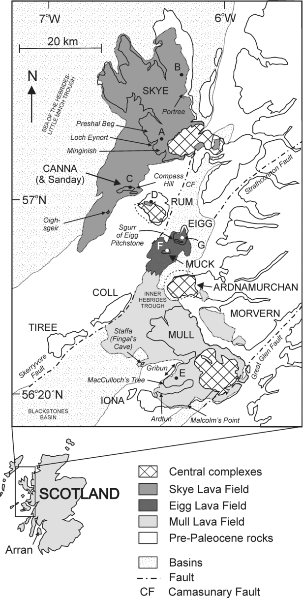
Maps indicating the position of the Paleocene central complexes and lava fields in NW Scotland. A–G – position of sections in Figure 4. NW–SE and NNW–SSE trending dyke swarms omitted for clarity. Structural and basin data after Fyfe, Long & Evans (Reference Fyfe, Long and Evans1993).

Evidence of sedimentary and volcano-tectonic activity has long been recognized in the BPIP, although early workers were more interested in the igneous activity, and so previous studies are typically restricted to brief descriptions and interpretations of the sedimentary rocks, and particularly plant macrofossils where present. However, appreciation of the importance of sedimentary processes in the history of the BPIP (and in volcanic sequences generally) has since grown, particularly over the last 30 years. This progress has come both as our wider understanding of sedimentological and volcanological products and processes has advanced, and as BPIP localities have been re-investigated in ever greater detail.
Here we review our existing knowledge on the sedimentary rocks of the BPIP; however, our objective is not to provide an exhaustive sedimentological description of all localities or a detailed chronology for each igneous centre, as this would not offer fresh perspective, and such information is available in the original publications (see reviews, Bell & Williamson, Reference Bell, Williamson and Trewin2002; Emeleus & Bell, Reference Emeleus and Bell2005). Rather, we aim to provide a broader conceptual framework, and have structured our review around four broadly chronological stages in the evolution of the BPIP volcanoes: (1) the development of the lava fields, (2) early intrusion-induced uplift, (3) caldera collapse and (4) post-volcano denudation and exhumation of central complexes. These four ‘framework’ stages are essentially chronological at individual BPIP volcanoes. At some localities, however, there is a degree of overlap between stages (e.g. lava field and central complex formation), while evidence for a particular stage may be contentious or absent at others. For each stage we briefly describe and illustrate the sedimentary and volcano-tectonic processes and products that have been identified at various localities in the BPIP, and where possible, discuss their approximate position with respect to the volcanic edifice.
2. Terminology
‘Volcaniclastic’ is used purely as a descriptive term for all fragmental deposits/rocks containing volcanic debris, and does not imply any fragmentation mechanism, transportation process or depositional setting. Therefore, ‘volcaniclastic’ may include, for example, pyroclastic rocks, and rocks formed from the weathering, erosion and transportation (‘reworking’) of lithified to unlithified pyroclastic rocks or lavas (often referred to in earlier studies as ‘epiclastic’) (Fisher Reference Fisher1961, Reference Fisher1966; Fisher & Schmincke, Reference Fisher and Schmincke1984; Cas & Wright, Reference Cas and Wright1987; Cas et al. Reference Cas, Porritt, Pittari and Hayman2008; cf. White & Houghton, Reference White and Houghton2006). The use of volcaniclastic as a purely descriptive term is particularly important in the BPIP where intense alteration and weathering make genetic classification of these rocks particularly difficult.
3. Geological setting
The BPIP (Fig. 1) constitutes a small but well-studied portion of the Palaeogene North Atlantic Igneous Province (NAIP), an example of a major and long-studied mafic Large Igneous Province. The NAIP developed on continental crust that thinned in response to the rifting and eventual sea-floor spreading associated with the opening of the North Atlantic Ocean (Thompson & Gibson, Reference Thompson and Gibson1991; Saunders et al. Reference Saunders, Fitton, Kerr, Norry, Kent, Mahoney and Coffin1997). Rifting has also been attributed to the impingement of the putative proto-Iceland plume on the base of the lithosphere (Saunders et al. Reference Saunders, Fitton, Kerr, Norry, Kent, Mahoney and Coffin1997). Vestiges of this NAIP magmatism are preserved onshore in west and east Greenland, the Faroe Islands, NW Scotland and NE Ireland, although a significant proportion of the Province is also preserved offshore (e.g. White & McKenzie, Reference White and McKenzie1989, Reference White and McKenzie1995) (Fig. 1).
3.a. Lava fields
In the NAIP, intense volcanic activity from fissure systems resulted in thick, laterally extensive sequences of sub-aerial flood basalt lavas, interbedded with rarer pyroclastic units. Equally significant was the development of hyaloclastite deltas where lavas entered water in adjacent sedimentary basins, for example, in central western Greenland, the Faroe–Shetland Basin and the Rockall Trough. An important feature of the volcanic sequences is the presence of interbedded sedimentary lithologies, both clastic and chemical, deposited in environments ranging from wholly terrestrial through to wholly marine (e.g. Saunders et al. Reference Saunders, Fitton, Kerr, Norry, Kent, Mahoney and Coffin1997; Jolley & Bell, Reference Jolley and Bell2002).
In the BPIP, fissure-fed lava fields filled Mesozoic basin structures (Thompson & Gibson, Reference Thompson and Gibson1991; Butler & Hutton, Reference Butler and Hutton1994) and are preserved on Eigg, Skye and Mull (Fig. 1). The lavas are typically sub-aerial alkali olivine basalts, although sub-aqueous examples are also present. Locally, the lavas are interbedded with sedimentary and volcaniclastic rocks, and palaeosols, although these units are typically laterally discontinuous and <10 m thick. These rocks are discussed in detail in Section 5 below.
3.b. Central complexes
Contemporaneous with these fissure-related lavas are laterally restricted volcanic sequences related to central volcanoes. Complex assemblages of shallow intrusive units, ranging in composition from peridotite through to granite, represent the solidified magma chambers of these volcanoes (Saunders et al. Reference Saunders, Fitton, Kerr, Norry, Kent, Mahoney and Coffin1997). These ‘central complexes’ include Skye and Rum in the Inner Hebrides of Scotland (see reviews, Bell & Williamson, Reference Bell, Williamson and Trewin2002; Emeleus & Bell, Reference Emeleus and Bell2005), Slieve Gullion, the Mournes and Carlingford in NE Ireland (see review, Mitchell, Reference Mitchell2004), and Skaergaard in east Greenland (Wager & Deer, Reference Wager and Deer1939; McBirney, Reference McBirney1975), and they offer an excellent opportunity to investigate crystallization and fractionation processes.
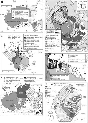
In the BPIP, central complexes are preserved onshore at Ardnamurchan, Arran, Mull, Rum and Skye, typically along, or near, the sites of pre-Paleocene faults (Figs 1, 2). The central complexes comprise a variety of shallow intrusions, including ‘nested’ plutons, laccoliths, lopoliths, stocks, ring-dykes, cone sheets and dykes. These intrusions cut the lava fields and/or country rocks, and have long been interpreted as the ‘roots’ of larger Paleocene volcanoes. However, at the present level of erosion these volcanic edifices are no longer preserved and thus little is known of their nature (caldera, stratovolcano, shield?), composition, geomorphology and physical volcanology.
Simplified geological maps of the central complexes of the BPIP. (a) Ardnamurchan. (b) Mull. (c) Rum. (d) Northern Marginal Zone of Rum Central Complex. (e) Skye. (f) Arran.

Extrusive igneous rocks are much less common in the BPIP central complexes, but where present they typically occur as isolated ‘screens’ between intrusions or as more continuous outcrops. They are often surrounded by arcuate or ring-shaped intrusions and/or ring-faults, and so were interpreted as subsided caldera fills (e.g. Mull and Rum) (Bailey et al. Reference Bailey, Clough, Wright, Richey and Wilson1924; Emeleus, Reference Emeleus1997; Troll, Emeleus & Donaldson, Reference Troll, Emeleus and Donaldson2000). Recently, rocks previously considered to be intrusive ‘felsites’ have also been re-interpreted as intra-caldera silicic pyroclastic rocks (e.g. Troll, Emeleus & Donaldson, Reference Troll, Emeleus and Donaldson2000; Holohan et al. Reference Holohan, Troll, Errington, Donaldson, Nicoll and Emeleus2009, this issue). The volcanic rocks preserved in the vicinity of the central complexes are also typically associated with various sedimentary units. These include coarse breccias, previously thought to represent explosive fragmental rocks associated with vents (e.g. Harker, Reference Harker1904; Bailey et al. Reference Bailey, Clough, Wright, Richey and Wilson1924; Richey & Thomas, Reference Richey and Thomas1930), but now interpreted as catastrophic mass wasting deposits associated with caldera and ‘sector’ collapse (e.g. Emeleus, Reference Emeleus1997; Troll, Emeleus & Donaldson, Reference Troll, Emeleus and Donaldson2000; Brown & Bell, Reference Brown and Bell2006, Reference Brown and Bell2007; Holohan et al. Reference Holohan, Troll, Errington, Donaldson, Nicoll and Emeleus2009, this issue). The evolution of thought on the nature and origin of these volcanic and sedimentary rocks is discussed in Sections 6 and 7.
3.c. Chronology
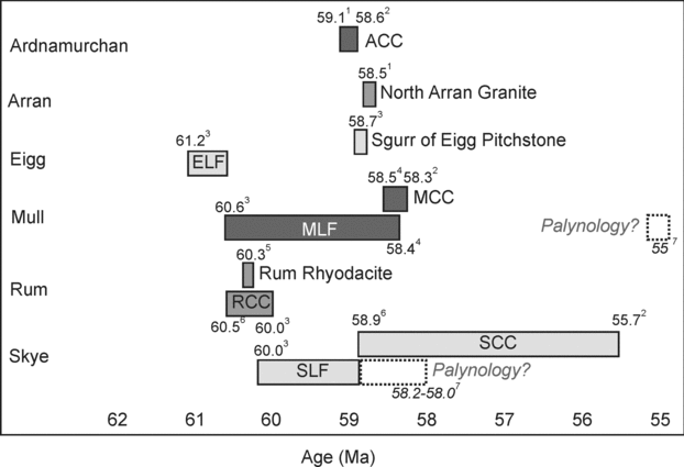
The majority of igneous activity in the BPIP occurred c. 60–55 Ma. The central complexes typically cut the lava fields but there is overlap between the different centres and lava fields. A simplified chronology of the BPIP is provided in Figure 3, based on cross-cutting relationships and radiometric dating.
Summary of the magmatic evolution of the BPIP based on field relationships and radiometric dating. At the time of compilation, the radiometric and palynological data were not fully reconciled. 1 – L. M. Chambers, unpub. Ph.D. thesis, Univ. Edinburgh, 2000 (Ar–Ar); 2 – M. A. Hamilton, unpub. data in Emeleus & Bell, Reference Emeleus and Bell2005 (U–Pb,); 3 – Chambers, Pringle & Parrish, Reference Chambers, Pringle and Parrish2005 (Ar–Ar); 4 – Chambers & Pringle, Reference Chambers and Pringle2001 (Ar–Ar); 5 – Troll et al. Reference Troll, Nicoll, Emeleus and Donaldson2008 (Ar–Ar); 6 – Hamilton et al. Reference Hamilton, Pearson, Thompson, Kelley and Emeleus1998 (U–Pb); 7 – Jolley, Reference Jolley and Widdowson1997 (palynology).

3.d. Uplift
During Paleocene times, the NAIP underwent transient uplift, attributed to the emplacement of the proto-Icelandic plume. Large volumes of basaltic melt were added to the crust over relatively short periods of geological time, raising the surface, and resulting in large amounts of clastic sediment being shed into surrounding basins (White & Lovell, Reference White and Lovell1997; Maclennan & Lovell, Reference Maclennan and Lovell2002; Mudge & Jones, Reference Mudge and Jones2004; Rudge et al. Reference Rudge, Shaw Champion, White, McKenzie and Lovell2008). Such uplift would lower base levels of erosional systems, leading to deeper incision of the palaeo-landsurface and rapid, increased erosion rates. In addition to this regional trend, localized uplift in the BPIP has been attributed to emplacement of the central complex intrusions, with direct evidence including folding and tilting of country rocks in the vicinity of the complexes (Fig. 2) and the generation of localized unconformities with structurally uplifted basement formations. The presence of mass wasting deposits also indicates locally elevated land surfaces, increased slope angles and erosion rates, and possible tectonism (Bailey et al. Reference Bailey, Clough, Wright, Richey and Wilson1924; Richey & Thomas, Reference Richey and Thomas1930; Richey, Reference Richey, MacGregor and Anderson1961; LeBas, Reference Le Bas1971; Jolley, Reference Jolley and Widdowson1997; Brown & Bell, Reference Brown and Bell2006, Reference Brown and Bell2007). Thus, the BPIP represents a dynamic, rapidly uplifting and eroding landscape on both regional and local scales.
3.e. Collapse
A variety of deposits associated with collapse of a volcanic landscape are identified in the BPIP. In particular, a distinction has arisen between mass wasting deposits formed by caldera collapse and those formed marginal to a postulated volcanic edifice and triggered by intrusion-induced uplift (‘sector’ collapse). At some localities, differentiation between the two is restricted by erosion and exposure. In this study, ‘calderas’ have been identified on the basis of: (1) the presence of ring-dykes and/or ring-faults at their margins, (2) a collapse succession of breccias and/or ignimbrites and (3) evidence of subsidence (e.g. displacement of country rocks). Intrusion-induced mass wasting deposits are identified on the basis of: (1) their position at the margins of the central complexes, (2) an absence of pyroclastic rocks and (3) the absence of any ring-dyke/fault structures. The term ‘sector collapse’ has generally been avoided, due to the uncertainty of the geomorphology of the postulated volcanic edifices.
3.f. Depositional environments
The BPIP was subject to warm and wet conditions associated with the internationally recognized Paleocene–Eocene Thermal Maximum and the temperature increases preceding this event (Jolley & Widdowson, Reference Jolley and Widdowson2005). Palynomorphs collected from sedimentary rocks interbedded with the lava fields of the Province reveal a landscape of upland Pine forests, and lowlands with mixed Mesophytic forests and broad valleys filled by tree ferns, flowering plants and swamp-dwelling flora (Jolley, Reference Jolley and Widdowson1997). These data are confirmed by the presence of leaf macrofossils, of types that thrive in warm, wet environments, in inter-lava sedimentary units (e.g. Ardtun Leaf Beds, Mull: Bailey et al. Reference Bailey, Clough, Wright, Richey and Wilson1924; Boulter & Kvacek, Reference Boulter and Kvacek1989). Palaeosols interbedded with the lava fields suggest intense chemical (and physical) weathering during this period (Jolley & Widdowson, Reference Jolley and Widdowson2005). The sedimentary rocks themselves provide evidence of a wide range of depositional environments in the BPIP, including upland areas prone to mass wasting events, as well as alluvial fans, braided rivers, lakes and swamps. These rocks are discussed in detail in Sections 5–7 below. This climate, together with uplift on a regional and local scale, facilitated the erosion of the volcanic landscape.
4. Rationale and constraints
In this review of sedimentary and volcano-tectonic processes in the BPIP, we are strongly constrained by the current level of erosion and locally, by poor exposure. The sedimentary units are typically laterally discontinuous, thin and/or obscured by intrusions. Likewise, volcano-tectonic processes such as caldera and sector collapse can be difficult to recognize due to the general scarcity of extrusive rocks associated with the postulated volcanoes of the central complexes, and/or the lack of clear volcano-tectonic structures (e.g. caldera-bounding faults). None the less, the preserved sedimentary, volcaniclastic and volcanic rocks do provide an insight into the geological evolution and palaeo-environments of the BPIP, not provided by the intrusive component, and as such, are worthy of further study.
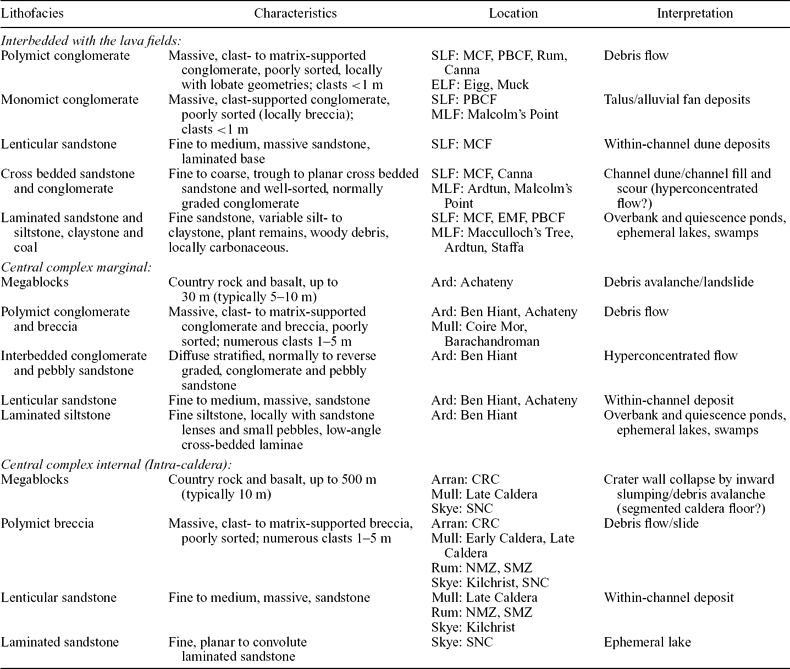
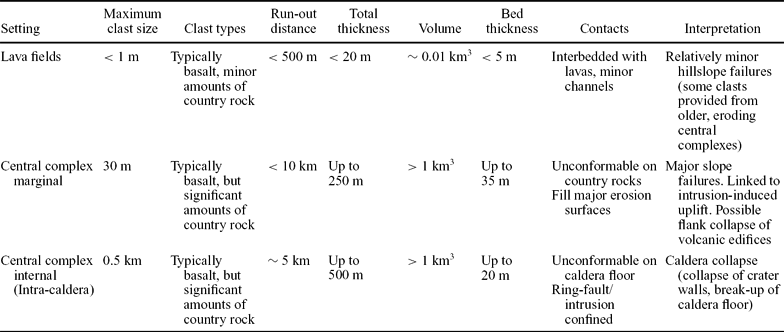
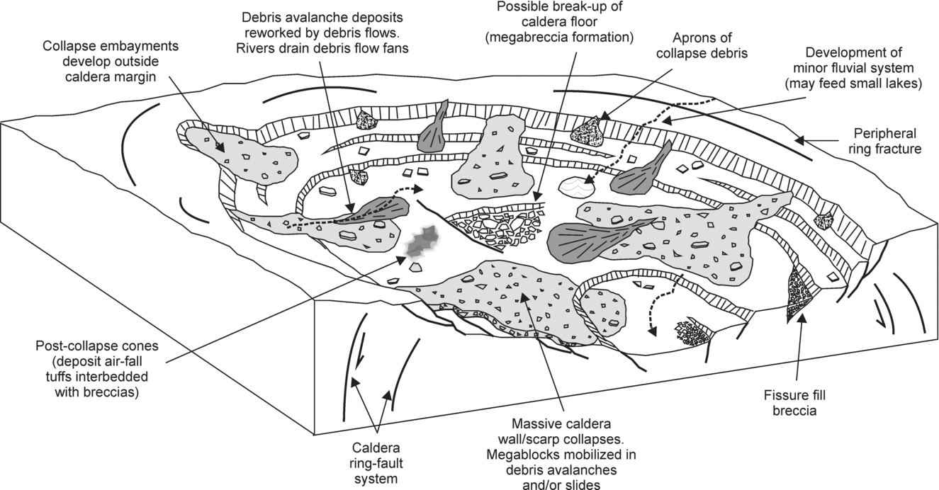
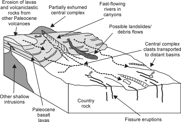
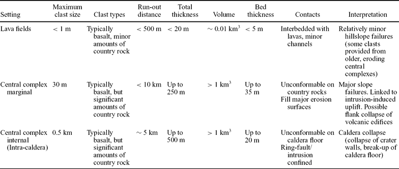
The paper is subdivided into four main, broadly chronological, themes (development of the lava fields, early intrusion-induced uplift, caldera collapse, and post-volcano denudation and exhumation of central complexes). It is important to note that although some of the processes outlined in these four themes are the same, they occur over a variety of scales and can be linked to distinct volcano-tectonic events. We aim to simplify the key processes and products of this part of the BPIP, while freely acknowledging that some overlap of these themes (in terms of their interpretation and spatial–temporal relationships) occurs. This chronological and process-driven approach is preferred to a more rigorous proximal versus distal subdivision of the sedimentary and volcaniclastic units, due to the uncertainties in the positions and nature of the volcanic edifices in space (e.g. the position of a pluton may not reflect the exact location of the contemporaneous edifice, due to lateral magma transport processes) and in time (e.g. edifice location may change with migration of foci of volcanic activity). It is not practical to provide a descriptive list of all localities in the BPIP, as: (1) there are simply too many and (2) most sedimentary units are discontinuous and spread over too wide an area to provide accurate lithofacies associations. However, as a compromise, the principal sedimentary lithofacies in each of the main sectors of the BPIP are provided in Table 1. A brief comparison of mass wasting products and their positions with respect to volcanic edifice is also provided in Section 8 and Table 2.
Summary of principal sedimentary lithofacies in the British Paleocene Igneous Province

ELF – Eigg Lava Field; MLF – Mull Lava Field; SLF – Eigg Lava Field; MCF – Minginish Conglomerate Formation; EMF – Eynort Mudstone Formation; PBCF – Preshal Beg Conglomerate Formation; Ard – Ardnamurchan; CRC – Central Ring Complex; SNC – Srath na Creitheach; NMZ – Northern Marginal Zone; SMZ – Southern Mountains Zone.
Comparison of mass wasting deposits in the British Paleocene Igneous Province
The localities described throughout the manuscript are based primarily on the authors’ published work (including recently collected unpublished data), together with recent published observations by other workers. Collectively, this synthesis represents the most detailed overview of these rocks in the BPIP so far, and is the first to formally conceptualize them within a generalized framework model of the sedimentary and volcano-tectonic processes.
5. The development of the BPIP lava fields and associated sedimentary units
In the BPIP (excluding Antrim in N. Ireland), three subaerial lava fields were erupted predominantly from NW–SE- to NNW–SSE-trending fissure systems (now represented by dyke swarms) and localized central vents (Walker, Reference Walker, Prichard, Alabaster, Harris and Neary1993a, Reference Walker, Prichard, Alabaster, Harris and Nearyb). Precise locations of vents remain obscure, although locally preserved accumulations of spatter and clastogenic lava are interpreted as vent-proximal products (Bell & Williamson, Reference Bell, Williamson and Trewin2002). Onshore remnants of these lavas are found on Eigg (including Muck and SE Rum), Skye (including Canna, Sanday and NW Rum) and Mull (including Morvern and Ardnamurchan).
The lavas filled pre-existing basins (e.g. Sea of the Hebrides–Little Minch Trough, Inner Hebrides Trough) that formed during Mesozoic rifting events (Thompson & Gibson, Reference Thompson and Gibson1991; Fyfe, Long & Evans, Reference Fyfe, Long and Evans1993; Butler & Hutton, Reference Butler and Hutton1994) (Fig. 1). The basins are NW-deepening half-graben bounded along their western margins by major normal faults of kilometre-scale offset (e.g. Camasunary–Skerryvore fault system) (Fig. 1). The distribution of the lavas is clearly controlled by these regional faults (e.g. the Eigg and Mull lava fields both terminate abruptly against the Camasunary Fault). Moreover, the position of the lava fields mainly to the NW of their respective central complexes may reflect a regional topographical gradient imparted by the underlying westward structural inclination of the half-graben. The extent to which such regional structural influences were active during lava field eruption or were simply a passive inheritance is unclear. There is some evidence, however, that displacement on these fault systems continued into the Paleocene: for example, the Camasunary Fault offsets lavas on Skye and east of Coll (Emeleus & Bell, Reference Emeleus and Bell2005) (Fig. 1), while the Long Loch Fault offsets the Rum Central Complex (Emeleus, Reference Emeleus1997) (Fig. 2c). This regional tectonic structure may thus have exerted a strong control upon the Paleocene landscape prior to the onset of, and perhaps during, BPIP magmatism (Emeleus & Bell, Reference Emeleus and Bell2005).
The bases of the lava fields unconformably overlie Mesozoic strata, Lower Palaeozoic sedimentary rocks, Neoproterozoic Moine schists, Neoproterozoic Torridonian sedimentary rocks and Archaean Lewisian gneisses, which were brought to the palaeo-land-surface by uplift and erosion (Bell & Williamson, Reference Bell, Williamson and Trewin2002). Volcanic activity typically commenced with the eruption of basaltic ash and scoria, followed by the extrusion of lavas into relatively shallow water (lakes), forming hyaloclastites (Anderson & Dunham, Reference Anderson and Dunham1966; Bell & Williamson, Reference Bell, Williamson and Trewin2002). The position of these lakes was most likely controlled by the trend of the half-grabens, as observed in the East African Rift system (e.g. Tiercelin, Reference Tiercelin1990; Klerkx, Theunissen & Delvaux, Reference Klerkx, Theunissen and Delvaux1998), an analogous continental rift. Volcanism then continued with the eruption of predominantly sub-aerial ‘plateau’ lavas, typically alkali olivine basalts, although more evolved examples (hawaiites, mugearites, benmoreites and trachytes) occur. The flows are typically tabular-classic simple flows, although compound-braided examples are also present locally (Jerram, Reference Jerram, Menzies, Klemperer, Ebinger and Baker2002; Single & Jerram, Reference Single and Jerram2004). The preserved sequences have thicknesses of several hundreds of metres, and on the basis of hydrothermal mineral zonation patterns, thicknesses in excess of 1 km are thought to have been removed during later erosion (Walker, Reference Walker, Murty and Rao1971).
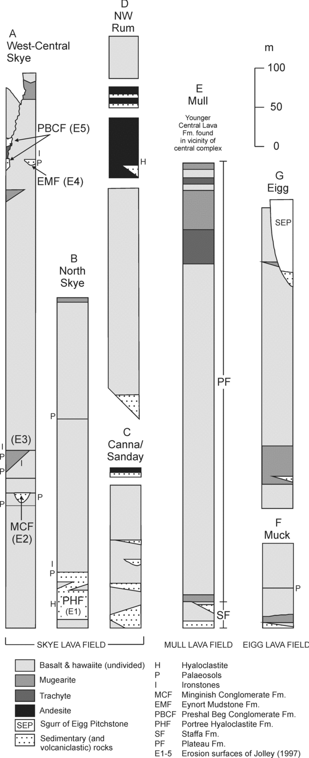
Relatively thick sedimentary sequences, locally up to 50 m thick, are found at or near the base of the lava fields (Fig. 4). These sedimentary units comprise sequences of breccias, conglomerates, sandstones, siltstones and claystones, together with some low-grade coals. Further up-sequence, sedimentary units typically become less common, and the majority of occurrences comprise reddened volcaniclastic sandstones, up to 2 m thick. Palaeosols, ranging from dull red through brown to green, and typically <1 m thick, are also present, becoming more common up-sequence (Fig. 4).
Generalized and composite vertical sections of lava fields in the BPIP (after Bell & Williamson, Reference Bell, Williamson and Trewin2002; Emeleus & Bell, Reference Emeleus and Bell2005).

5.a. Skye Lava Field
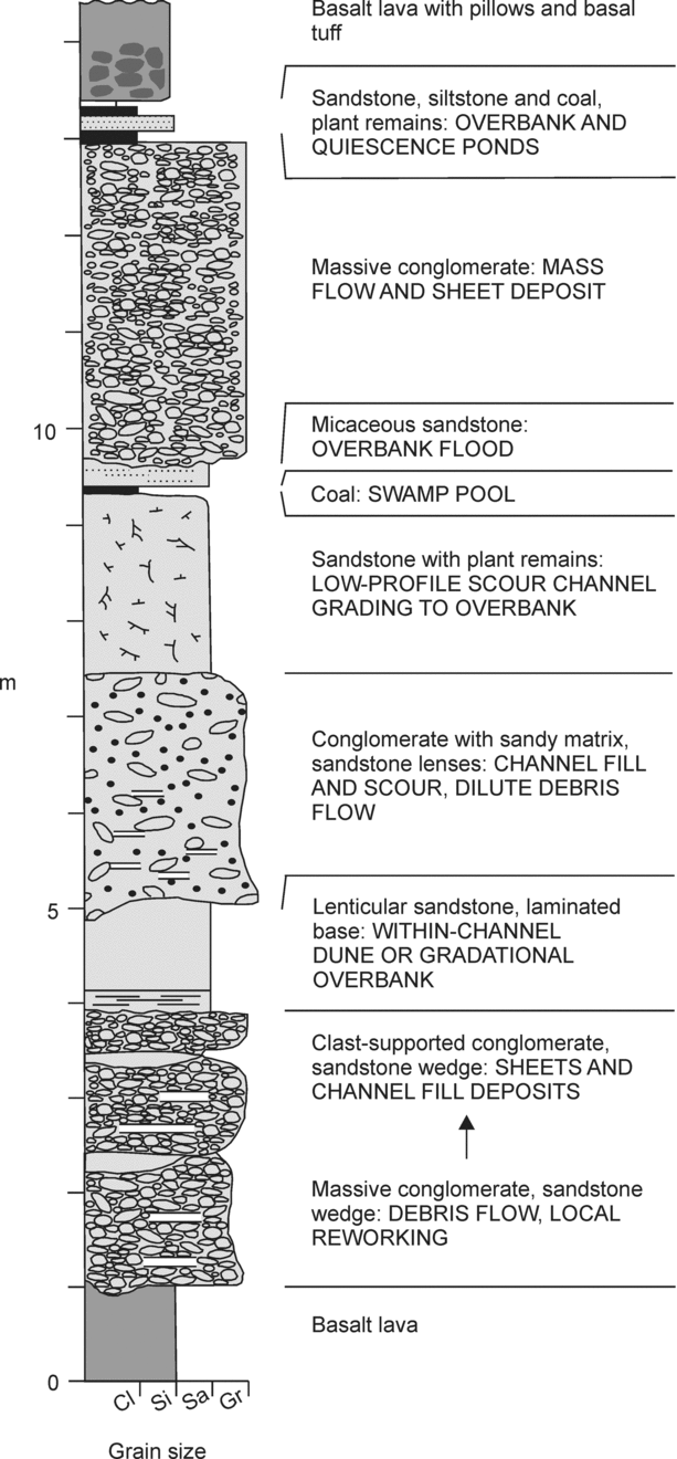
In west-central Skye, three main sedimentary sequences, the Minginish Conglomerate Formation, the Eynort Mudstone Formation and the Preshal Beg Conglomerate Formation, are recognized (Figs 1, 4: section A; Table 1). The Minginish Conglomerate Formation comprises three members, typically 10–15 m thick, of which the Allt Geodh’ a’ Ghamhna Member is representative (Fig. 5) (Williamson & Bell, Reference Williamson and Bell1994). This member comprises three cycles, each of which typically contains packages of massive conglomerates, lenticular sandstone bodies and localized coals/siltstones with plant remains. The conglomerates were deposited by high-energy debris flow processes, and locally fine up into high- to low-energy sheet and channel fill sandstone deposits. The lenticular sandstone bodies are interpreted as within-channel dune deposits, and the coals and siltstones as overbank and swamp pool deposits. The other members of the Minginish Conglomerate Formation include fine to coarse sandstones with trough to planar cross-bedding, indicative of channel dune/channel fill and scour, and bar deposition. Overall, the Minginish Conglomerate Formation conglomerate–sandstone–siltstone–coal sequences are interpreted as the alluvial–fluvial deposits of braided river systems (Williamson & Bell, Reference Williamson and Bell1994).
Stratigraphical log for the Allt Geodh’ a’ Ghamhna Member [NG 3690 1970] of the Minginish Conglomerate Formation, Skye (after Williamson & Bell, Reference Williamson and Bell1994).

The 2–15 m thick Eynort Mudstone Formation (Fig. 4: section A) typically comprises claystones, siltstones, ironstones, carbonaceous shales, thin coals and numerous thick ‘laterites’ (palaeosols). These sequences indicate shallow (ephemeral?) lakes and swamp ponds, and intense periods of weathering (Williamson & Bell, Reference Williamson and Bell1994). The Preshal Beg Conglomerate Formation (Fig. 4: section A) is up to 20 m thick and comprises volcaniclastic conglomerate, breccia, sandstone, and laminated, rarely carbonaceous siltstone. These coarse units are typically poorly sorted, and are thought to represent talus and alluvial fan deposits. Coarse units with lobate geometries and chaotic assemblages have been interpreted as debris flow deposits, whereas the fine units are thought to represent transient lakes fed by small streams draining the alluvial fan-complex (Williamson & Bell, Reference Williamson and Bell1994).
In Northern Skye, similar alluvial–fluvial to lacustrine sequences, with rare plant macrofossils in the finer units (Anderson & Dunham, Reference Anderson and Dunham1966) and volcaniclastic deposits are preserved (Bell et al. Reference Bell, Williamson, Head and Jolley1996). At the base of the lava field, the up to 40 m thick Portree Hyaloclastite Formation comprises hyaloclastites, pillow lavas and various volcaniclastic sandstones and siltstones (Fig. 4: section B). The recognition of hyaloclastites and pillow lavas indicates the presence of small lakes and sub-aqueous environments (Anderson & Dunham, Reference Anderson and Dunham1966).
On Canna, Sanday and NW Rum, part of the Skye Lava Field, the Canna Lava Formation, is exposed. On Canna and Sanday the lavas are interbedded with conglomerate–sandstone–siltstone sequences, interpreted to be of fluviatile origin (Emeleus, Reference Emeleus1973, Reference Emeleus1985, Reference Emeleus1997) (Fig. 4: section C). On east Canna at Compass Hill (Fig. 1), the conglomerates are ~50 m thick, contain clasts up to 2 m across, and are poorly sorted, suggesting a possible debris flow origin (Bell & Williamson, Reference Bell, Williamson and Trewin2002). On Rum, the lavas are also interbedded with thick conglomerate–sandstone–siltstone sequences, and fill palaeo-valleys in bedrock granite and Torridonian sandstone (Fig. 4: section D). The fine-grained units preserve leaf impressions and carbonized logs. The conglomerates and sandstones are interpreted as fluviatile units deposited by fast-flowing streams and rivers in steep-sided valleys, and the siltstones as localized lacustrine deposits (Emeleus, Reference Emeleus1985, Reference Emeleus1997).
5.b. Mull Lava Field
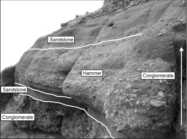
The lowermost Staffa Formation of the Mull Lava Field contains several well-exposed sedimentary sequences (Fig. 4: section E). The base of the Staffa Formation is marked by the 1–6 m thick, laterally impersistent Gribun Mudstone Member (Fig. 1), which comprises reddish-orange mudstone or calcareous mudstone. This volcaniclastic mudstone is interpreted as an extremely weathered basaltic ash, developed during a major hiatus in volcanism (Bell & Williamson, Reference Bell, Williamson and Trewin2002). In the area around Malcolm's Point (Fig. 1), lavas near the base of the Staffa Formation overlie a heterogeneous sequence of conglomerates consisting of a basal deposit dominated by basalt clasts, overlain by coarse-grained, flint-dominated (derived from Cretaceous chalk deposits), clast-supported, trough-bedded conglomerates, capped by basalt-dominated, clast-supported conglomerates. Exposures of volcaniclastic sandstone, extremely poorly sorted basalt–flint conglomerate, basaltic sandstone and mudstone are preserved laterally (Fig. 6). Together, these units represent a complex sequence of alluvial fan, channel and debris flow deposits. The flint clasts in the conglomerates indicate erosion and transportation of material from ‘highlands’ of Cretaceous rock (Bell & Williamson, Reference Bell, Williamson and Trewin2002).
Basalt-flint conglomerate–sandstone sequence, east of Malcolm's Point, Staffa Formation, Mull. Hammer is 30 cm in length.

Claystone–siltstone–coal sequences are also preserved in the Staffa Formation on southern Mull, in particular below the famous Macculloch's Tree Flow (MacCulloch, Reference MacCulloch1819), which contains the cast of a large conifer tree, and below the Fingal's Cave Flow on Staffa, which contains abundant woody debris (Bell & Williamson, Reference Bell, Williamson and Trewin2002) (Fig. 1). The Ardtun Conglomerate Member (Fig. 1) marks another major volcanic hiatus in the Staffa Formation and comprises a conglomerate–sandstone–siltstone sequence. The conglomerates occur in trough-bedded sets with sandstone lenses, while parallel and ripple laminae are present in some of the sandstones. These units represent alluvial fan and fluvial deposits (Bell & Williamson, Reference Bell, Williamson and Trewin2002). The siltstones overlie a thin coal and contain well-preserved leaves at the famous Ardtun Leaf Beds, and represent riparian overbank and lacustrine deposits (Boulter & Kvacek, Reference Boulter and Kvacek1989; Jolley, Reference Jolley and Widdowson1997).
The lavas of the Staffa Formation typically exhibit well-developed columnar joints, pillowed/hyaloclastite facies and laterally restricted lensoid geometries. These characteristics, together with the argillaceous nature of the sedimentary rocks, indicate that the lavas were erupted into lakes and swamps impounded within broad, well-vegetated valleys, which formed part of an actively subsiding graben (Bell & Williamson, Reference Bell, Williamson and Trewin2002; Jolley et al. Reference Jolley, Bell, Williamson and Prince2009). Syn-depositional movement on graben margin faults is indicated by thick alluvial sedimentary rocks and ponded lava flows on the downthrown sides (Bell & Williamson, Reference Bell, Williamson and Trewin2002; Jolley et al. Reference Jolley, Bell, Williamson and Prince2009).
Sedimentary units are relatively rare in the overlying Plateau Formation of the Mull Lava Field (including Morvern and Ardnamurchan) and typically consist of thin volcaniclastic sandstones and siltstones. Weathered flow tops and thin, discontinuous palaeosols are present in both the Staffa and Plateau formations, indicating intense weathering and perhaps the location of kipuka (‘islands’ of land surrounded by lava flows) during formation of the lava field.
5.c. Eigg Lava Field
The Eigg Lava Field is exposed onshore on Eigg and Muck and as fault-controlled slivers on SE Rum (Emeleus, Reference Emeleus1997). Sedimentary units are typically restricted to thin reddish-orange volcaniclastic sandstones and siltstones between the lavas, and represent reworked trachytic material (Emeleus et al. Reference Emeleus, Allwright, Kerr and Williamson1996). A breccia–sandstone unit comprising locally available Jurassic clasts is exposed at the base of the lava field on the south coast of Muck (Fig. 4: section F), and is of apparent mass flow origin. Three post-lava masses of conglomerate, up to 50 m thick, are exposed on the west coast of Eigg beneath the Sgurr of Eigg Pitchstone (Fig. 4: section G), and have been interpreted as fluviatile conglomerates filling a palaeo-valley (Emeleus, Reference Emeleus1997). However, the overall motif of these deposits is extremely chaotic, with clasts up to 2 m across and numerous examples of both angular and rounded blocks. The conglomerates are thus more likely to be valley-confined debris flow deposits locally interbedded with hyperconcentrated flow deposits.
5.d. Processes
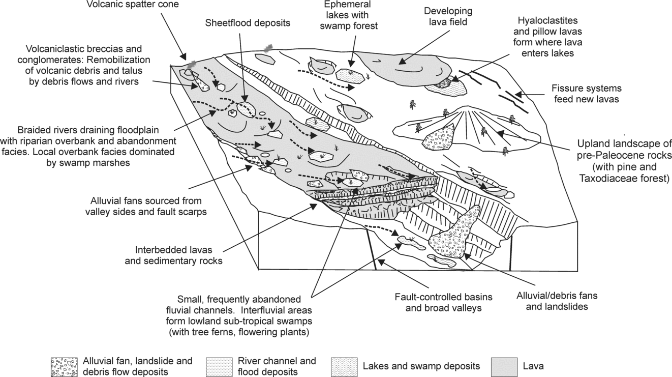
Although formed independently in space and time, the three main lava fields of the BPIP display a similar range of palaeo-environments and sedimentary processes (Table 1). Field and palynological evidence indicate that the lavas were typically emplaced into a series of broad valleys comprising alluvial fans, braided rivers, lakes and swamps (Fig. 7). Palynological analysis of inter-lava lithologies on Skye and Mull demonstrates the presence of montane conifer forests, upland Taxodiaceae forests (similar to extant Redwood species) and mixed mesophytic forests (swamp plants, tree ferns) in lowland areas (Jolley, Reference Jolley and Widdowson1997; Bell & Jolley, Reference Bell and Jolley1997; Bell & Williamson, Reference Bell, Williamson and Trewin2002). Conglomerate–sandstone–siltstone–coal sedimentary assemblages were deposited on this landscape, and locally they are superimposed, indicating repeated waxing and waning of current activity.
Schematic diagram illustrating a generalized interpretation of sedimentary processes during development of lava fields. This reconstruction depicts an amalgamation of features from throughout the BPIP and does not refer to any particular locality.

Coarse conglomerates or breccias are typically deposited by: (1) gravity (e.g. talus or alluvial fan accumulations on steep valley slopes), (2) debris flows (occurring on steep slopes, or in well-defined channels, valleys, or even canyons) and (3) braided rivers. Deposits characteristic of these three processes are present in the BPIP.
Talus/alluvial fan deposits interbedded with the lava fields in the BPIP are typically monomict, clast-supported, poorly sorted, conglomerates (and breccias), such as the Preshal Beg Conglomerate Formation, Skye, and at Malcolm's Point, Mull (Table 1). Their monomict nature indicates the existence of discrete ‘highlands’ or elevated areas of pre-Paleocene lithologies.
Debris flows are typically initiated in mountainous areas from failures of soil, regolith and/or weathered bedrock, commonly triggered by heavy rainfall, resulting in water–debris slurries (Johnson, Reference Johnson, Brunsden and Prior1984; Smith, Reference Smith1986; Pierson & Costa, Reference Pierson, Costa, Costa and Wieczorek1987; Smith & Lowe, Reference Smith, Lowe, Fisher and Smith1991). They typically form massive, polymict, poorly sorted conglomerates and breccias, as seen in the BPIP in Eigg, Muck, Rum, Canna, and the Minginish and Preshal Beg Conglomerate formations of Skye (Table 1). The warm and wet climate of the Paleocene (Jolley, Reference Jolley and Widdowson1997), and perhaps volcanic activity and tectonic instability, would have been contributory factors in debris flow initiation in the BPIP.
Debris flows may transform distally into hyperconcentrated and sediment-laden stream flows by either: (1) incorporation of over-run ambient streamwater and/or (2) deposition of particulate material (Pierson & Scott, Reference Pierson and Scott1985; Scott, Reference Scott1988; Best, Reference Best1992; Scott, Vallance & Pringle, Reference Scott, Vallance and Pringle1995). Debris flows are transported along, and deposit their sediments in, broad valleys with rivers, where they are subject to mixing with ambient water. The flows may become longitudinally segregated, comprising a preceding debris flow and a trailing dilute flow (Sohn, Rhee & Kim, Reference Sohn, Rhee and Kim1999). Both mixing and segregation can give rise to deposits of coarse conglomeratic facies overlain by finer, sandier facies. Following deposition, some of this clastic material can be reworked by more conventional sedimentary processes (e.g. fluvial, upon re-establishment of background sedimentation) to produce stratified sandstones. Such transformation and reworking processes may have produced the sandy conglomerates, pebbly sandstones and stratified sandstones of the type seen on Mull and Skye (Table 1).
Cross-bedded sandstones and conglomerates, both locally normally graded and/or well sorted, and lenticular sandstone bodies, are indicative of fluvial activity. Such units are preserved on Mull, Skye, Rum, Eigg and Canna (Table 1), and indicate that fast-flowing rivers and streams drained the Paleocene landscape. Trough and planar cross-bedded sandstones are indicative of minor channel switching and migration. In the BPIP, channels were formed on alluvial/debris fan surfaces (e.g. Allt Geodh’ a’ Ghamhna Member, Skye), or were carved into underlying rocks of Paleocene or older age (e.g. Canna Lava Formation, Rum). However, well-developed accretion surfaces such as point bars are absent, which suggests that mature, meander-belt fluvial sedimentation did not develop (Williamson & Bell, Reference Williamson and Bell1994). In high-flow regimes, overbank flood deposits can accumulate, and thin, massive sandstones in the Skye and Mull Lava fields record such events (Table 1).
Small lakes, swamps and overbank/quiescence ponds develop in valley floors/floodplains, and claystones and siltstones are deposited. In modern lava fields, overlapping, undulating and collapsed lava (e.g. lava tube collapse) can also form numerous depressions capable of holding small bodies of standing water (Kiernan, Wood & Middleton, Reference Kiernan, Wood and Middleton2003). Such water bodies become small-scale ephemeral depocentres. Laminated claystones, siltstones and fine sandstones, often with plant remains and woody debris, on Mull, Skye, Rum, Eigg and Canna (Table 1) (Emeleus, Reference Emeleus1985, Reference Emeleus1997; Williamson & Bell, Reference Williamson and Bell1994; Jolley, Reference Jolley and Widdowson1997; Bell & Williamson, Reference Bell, Williamson and Trewin2002) are indicative of similar, low-energy, depositional environments. Palynological data from the BPIP also confirm a well-vegetated landscape with extensive plant communities, whose decay culminated in the formation of thin coals. Riparian communities were common in channel areas (Jolley, Reference Jolley and Widdowson1997).
As discussed in Section 3.f, the BPIP was subject to warm and wet conditions. This climate promoted chemical weathering, indicated by the oxidation (reddening) of many sedimentary and palaeosol sequences interbedded with the lava fields, and the presence of thick weathering profiles on lava surfaces. In the BPIP, sedimentary units are more abundant at, or near, the bases of the lava fields, giving way to palaeosols up-sequence. As outlined above, the earlier lavas and sedimentary rocks were emplaced into broad valleys with steep slopes, which helped to generate sediments. However, with time the lavas filled this accommodation space and progressively reduced the topographical relief. As a result, later lavas were emplaced over a more topographically subdued landscape, such that erosion and deposition in these areas were gradually suppressed.
6. Early sedimentary response to intrusion-induced uplift
The fissure-fed lava fields of the BPIP were intruded by upwelling basaltic and rhyolitic magmas, which developed into large central complexes, up to 15 km in diameter, on Ardnamurchan, Arran, Mull, Rum and Skye (Figs 1, 2). At the present level of erosion, these central complexes comprise an elaborate association of coarse-grained intrusions, dykes, confluent cone-sheets, ring-dykes and stocks (Walker, Reference Walker, Prichard, Alabaster, Harris and Neary1993a, Reference Walker, Prichard, Alabaster, Harris and Nearyb), and are interpreted as the shallow (<2 km) hearths of large Paleocene volcanoes. The development of these intrusive complexes (and their surface volcanic cones) was responsible for considerable uplift (perhaps up to 1 km), doming and deformation of the lava fields and country rocks (Bailey et al. Reference Bailey, Clough, Wright, Richey and Wilson1924; Richey & Thomas, Reference Richey and Thomas1930; Richey, Reference Richey, MacGregor and Anderson1961; LeBas, Reference Le Bas1971; Jolley, Reference Jolley and Widdowson1997). In this section we outline the early sedimentary response to these volcano-tectonic uplift events.
6.a. Ardnamurchan
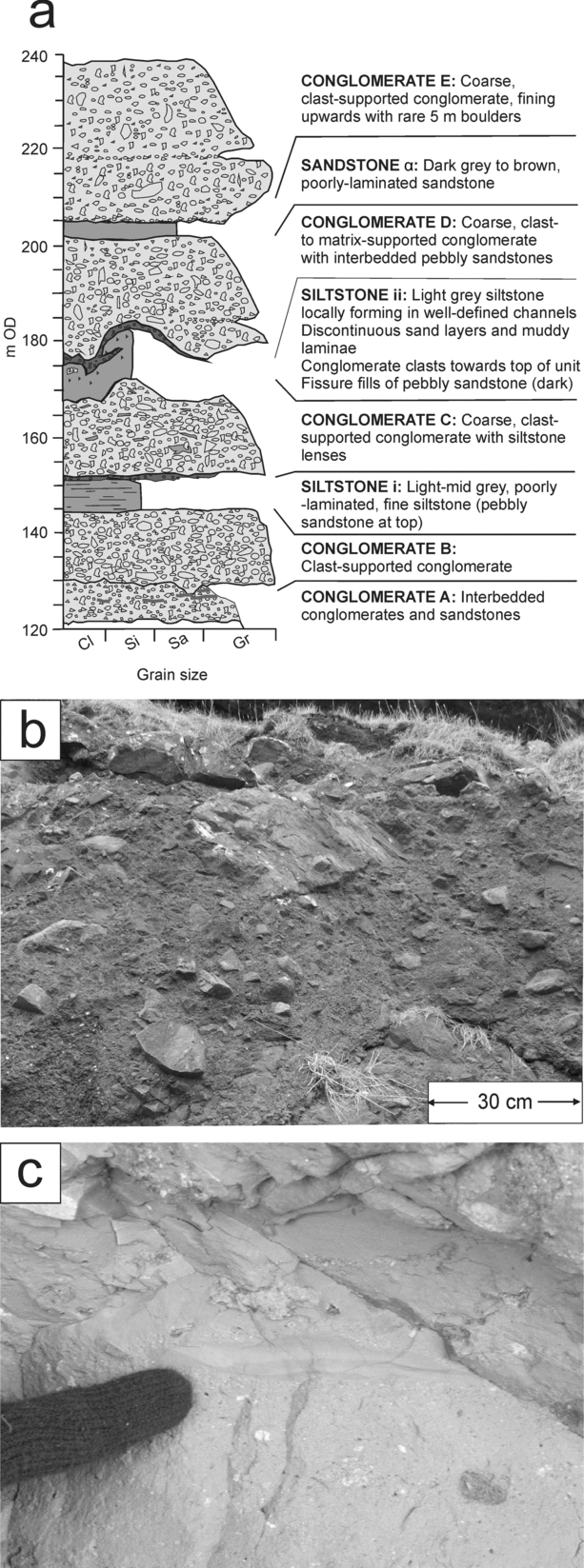
Two large outcrops of volcaniclastic rocks occur on the Ardnamurchan Peninsula, around Ben Hiant (Ben Hiant Member) in the south, and the Achateny Valley (Achateny Member) in the north (Fig. 2a). Both rest unconformably on Paleocene basalt lavas and older country rocks. The outcrops are dominated by massive to poorly bedded, dark brown to black to grey, coarse-grained, poorly sorted, clast-supported conglomerates (and rarer breccias) with a matrix of comminuted sand-grade basaltic material (Table 1; Fig. 8a, b). Clasts range in size from particles a few millimetres across up to blocks metres across, and locally, megablocks up to 30 m across are present. Clasts are chaotically organized, sub-rounded to sub-angular, and typically 2 cm to 1 m across. In the Ben Hiant Member (Fig. 8), the conglomerates are stratified with well-developed, commonly undulating, erosive bases, and are interbedded with laterally discontinuous, poorly laminated siltstones (Fig. 8c) and sandstones, some of which fill topographical depressions, oriented N–S, on the underlying conglomerates (Fig. 8a). Clasts are predominantly basalt from the subjacent Mull Lava Field, although locally concentrations of Mesozoic country rock and other ‘exotic’ lithologies, including welded rhyolitic ignimbrite, are present. In places, the clasts are imbricated, indicating palaeoflow to the south and SW. Clast roundness, size and degree of clast-support, all increase towards the south. To the south of Ben Hiant a sequence (~8 m thick and 15 m across) of tuff, lapilli–tuff and breccia overlies the conglomerates and is the first in situ evidence of pyroclastic activity in the Ardnamurchan area (D. J. Brown, unpub. data).
(a) Stratigraphical log located NE of MacLean's Nose, Ben Hiant, Ardnamurchan [NM 5370 6194], depicting strata and characteristics of the Ben Hiant Member. (b) Matrix-supported conglomerate/breccia from Conglmerate B of the Ben Hiant Member. (c) Muddy laminae in Siltstone ii of the Ben Hiant Member.

In the Achateny Member, the conglomerates are poorly stratified, although locally, units with distinctive clast assemblages form lobes, fill topographical depressions (~1–2 m relief) and display normal grading. Rare imbrication indicates palaeoflow was to the north and northwest. The dominant clast types are basalt and Mesozoic sedimentary rocks. Clast roundness, size and degree of clast-support all increase towards the north.
The Ben Hiant and Achateny volcaniclastic rocks were originally interpreted as explosive vent deposits, thought to represent pyroclastic ‘agglomerates’ and ‘tuffs’ (Richey & Thomas, Reference Richey and Thomas1930; Richey, Reference Richey1938). Richey's interpretation involved repeated, or ‘rhythmic’, explosive eruptions of trachytic magma. However, recent work (Brown & Bell, Reference Brown and Bell2006, Reference Brown and Bell2007) has demonstrated the absence of any primary pyroclastic material in these deposits. The coarse units were re-interpreted as sedimentary conglomerates and/or breccias, whose chaotic nature, together with the magnitude of some clasts (up to 30 m), indicate that they were formed by extremely high-energy mass flow events (Brown & Bell, Reference Brown and Bell2006, Reference Brown and Bell2007). Clast textures suggest dominant deposition by debris flow, although it is possible that landslide, talus accumulation and debris avalanche mechanisms were also involved. The interbedded siltstones and sandstones are interpreted as having been deposited in low-energy fluvio-lacustrine environments, during hiatuses in, or shortly after, debris flow deposition (Brown & Bell, Reference Brown and Bell2006, Reference Brown and Bell2007).
Palynological analysis of the fine-grained units also provides information on the palaeo-geography and palaeo-botany of the Ardnamurchan landscape (Brown & Bell, Reference Brown and Bell2006, Reference Brown and Bell2007), which comprised upland areas with a mature pine forest vegetation, and rivers and streams draining into lowland areas within broad valleys. Locally, small rivers fed swamps and lakes (filling depressions on lava flows?), which supported a dense vegetation of ferns and flowering plants. Clast–matrix fabric analyses, together with topographical depressions, interpreted as channel axes, and imbrication data, are used to identify a ‘sedimentary watershed’, or ‘drainage divide’, from which the conglomerates were deposited to the north and south. The debris flows were transported over several kilometres, from upland, mountainous areas into more topographically subdued lowlands and valley floors, where they were finally deposited. The interbedded siltstones and sandstones were deposited by rivers and lakes in these lowland areas (Brown & Bell, Reference Brown and Bell2006, Reference Brown and Bell2007).
The Ardnamurchan conglomerates were deposited synchronous with intrusion as they both contain clasts of, and are cut by, petrographically distinctive dolerite cone sheets of the central complex (Richey & Thomas, Reference Richey and Thomas1930; Brown & Bell, Reference Brown and Bell2006, Reference Brown and Bell2007). The cumulative thickness of cone sheets intruded into the area around Ardnamurchan is over 1 km (Richey & Thomas, Reference Richey and Thomas1930), and although it is difficult to quantify their surface expression, broad structural uplift associated with their emplacement at shallow levels is probable. Similar kilometre-scale uplift induced by cone-sheet emplacement has been calculated for Gran Canaria (Schirnick, Bogaard & Schmincke, Reference Schirnick, van den Bogaard and Schmincke1999). Radially outward dip directions in the Mesozoic strata flanking the Ardnamurchan igneous centre (Fig. 2a) are further evidence for uplift and doming associated with its intrusion. This intrusion-induced uplift would have led to increased slope angles and tectonic instability around the Ardnamurchan volcanic centre, and thus provided a mechanism for the resultant, catastrophic, mass wasting events.
6.b. Mull
Coarse, fragmental deposits are located at Coire Mor and Barachandroman at the east and SE margin of Centre 1 of the Mull Central Complex (Fig. 2b, Table 1). Although relationships are obscured by a plethora of cone sheets, particularly at Coire Mor, these rocks comprise a thick succession of grey-brown, coarse, poorly sorted matrix-supported breccias, containing sub-angular to rounded clasts (Paleocene igneous lithologies and pre-Paleocene sedimentary rocks), ranging in size from 2 cm to 50 cm across, with rarer blocks up to 3 m. A series of annular folds (the ‘Coire Mor and Loch Spelve Synclines’), which Bailey et al. (Reference Bailey, Clough, Wright, Richey and Wilson1924) attributed to intrusion of the central complex, are located at the east and SE margins of the Mull Central Complex. Lavas in the vicinity of the complex are ‘domed’ and, in places, unconformably overlain by the breccias, which are not folded. Bailey et al. (Reference Bailey, Clough, Wright, Richey and Wilson1924) interpreted the Coire Mor and Barachandroman deposits as ‘surface accumulations’, and suggested that ‘the lavas were breaking up under sub-aerial decay at the time of breccia formation’, although Richey (Reference Richey, MacGregor and Anderson1961) argued they were explosion breccias formed by subsurface gas brecciation. New observations, including the discovery of small channels (<5 m across, <1 m deep) and graded beds (up to 5 m thick) confirm that these breccias are surface, sedimentary deposits of mass flow origin (D. J. Brown, unpub. Ph.D. thesis, Univ. Glasgow, 2003).
6.c. Rum
Upwelling silicic and mafic magmas caused folding, outward-tilting and ~1.5 km of uplift of overlying Torridonian and Lewisian country rocks on Rum. Much of this uplift (and later subsidence; see Section 7.a) was accommodated along the Main Ring Fault system, a set of steeply inclined arcuate faults, which delimit the Rum Central Complex (Bailey, Reference Bailey1945; Emeleus, Reference Emeleus1997; Troll, Emeleus & Donaldson, Reference Troll, Emeleus and Donaldson2000) (Fig. 2c). The sedimentary response to this uplift involved the rapid erosion and removal of up to 1 km of country rock overlying the developing magmatic system. This is evidenced within the Northern Marginal Zone and Southern Mountains Zone (Fig. 2c) by a marked unconformity inside the Main Ring Fault, between uplifted Torridonian and Lewisian rocks from the base of the pre-Paleocene stratigraphy, and directly overlying breccias, sandstones and ignimbrites of Paleocene age (Section 7.a) (Emeleus, Reference Emeleus1997; Troll, Emeleus & Donaldson, Reference Troll, Emeleus and Donaldson2000; Holohan et al. Reference Holohan, Troll, Errington, Donaldson, Nicoll and Emeleus2009, this issue). Moreover, stratigraphical and structural data indicate that the breccias and ignimbrites were, at least locally, deposited in palaeo-valleys orientated radially outwards from the centre (Troll, Emeleus & Donaldson, Reference Troll, Emeleus and Donaldson2000; Holohan et al. Reference Holohan, Troll, Errington, Donaldson, Nicoll and Emeleus2009, this issue); these observations are compatible with erosion of, and deposition onto, an uplifted and domed palaeo-surface. This uplift process likely contributed to the genesis of some of the lower-level breccias currently preserved inside the Main Ring Fault (see Holohan et al. Reference Holohan, Troll, Errington, Donaldson, Nicoll and Emeleus2009, this issue), but the extent to which the whole sequence can be accounted for by this mechanism is unclear, as influences from later caldera collapse must also be considered (see Sections 7.a and 8, below).
6.d. Skye
The country rocks marginal to the Skye Central Complex (pre-Paleocene sedimentary rocks and Paleocene basalt lavas) show evidence for structural uplift, including circumferential-folding and outward-tilting (Butler & Hutton, Reference Butler and Hutton1994), similar to Ardnamurchan and Rum. Palynological analysis of sedimentary units from the Skye Lava Field also provides evidence for a major elevation change. Palynomorphs found within these sedimentary units indicate a landscape with montane conifer forests, upland Taxodiaceae forests, and mixed mesophytic forests in lowland areas (Jolley, Reference Jolley and Widdowson1997). Correlation of these units in west-central Skye has allowed the recognition of five distinct erosion surfaces (all of which were formed in a period of <0.24 Ma, at ~58 Ma; see Fig. 3), each of which can be linked to distinct geomorphological and palynological features (Jolley, Reference Jolley and Widdowson1997) (Fig. 4: section A). Between two of these erosion surfaces (E3 and E4), the palynofloras indicate a change in palaeo-elevations from 100–200 m to 1200 m, implying a major uplift of around 1 km during this period (about 58 Ma). This rapid elevation change has been attributed to emplacement of the Skye Central Complex and a major period of erosion has been suggested, although no direct sedimentary evidence is now preserved (Jolley, Reference Jolley and Widdowson1997).
6.e. Process
Shallow intrusion has been cited as a triggering mechanism for mass wasting events in other ancient flood basalt provinces (Mawson Formation debris avalanche deposits, Antarctica: Reubi, Ross & White, Reference Reubi, Ross and White2005), and in active volcanoes such as Hawai'i and certain of the Canary Islands (Moore, Normark & Holcomb, Reference Moore, Normark and Holcomb1994; Moore et al. Reference Moore, Bryan, Beeson and Normark1995; Masson et al. Reference Masson, Watts, Gee, Urgeles, Mitchell, Le Bas and Canals2002). In the Hawai'i and Canary Island examples, thick accumulations of lava are present, generating high relief, but slope angles are relatively low. This demonstrates that the large mass wasting events recorded do not necessarily require oversteepened slopes, of the type found at stratovolcanoes. Reubi, Ross & White (Reference Reubi, Ross and White2005) noted the presence of debris avalanche deposits containing megablocks up to 80 m across, in the Jurassic Ferrar Large Igneous Province, Antarctica. These deposits were generated early in the formation of this LIP and comprise sedimentary material derived from underlying units. The debris avalanche deposits also contain ovoid to spherical bodies of basalt, interpreted as hot, fluid intrusions of early Ferrar LIP material. Based on these relationships, Reubi, Ross & White (Reference Reubi, Ross and White2005) suggested that debris avalanches can accompany LIP volcanism, despite the common absence of large central volcanic edifices, and that a combination of uplift, normal faulting and contemporaneous emplacement of shallow intrusions is the most likely cause of collapse. The BPIP offers an important window into such LIP processes because the level of exposure allows us to directly see evidence for both the uplift associated with shallow intrusion, and the sedimentary response.
Doming, structural elevation and/or concentric folding of country rocks provide evidence of uplift and deformation during intrusion of the Ardnamurchan, Mull, Rum and Skye central complexes (Bailey et al. Reference Bailey, Clough, Wright, Richey and Wilson1924; Richey & Thomas, Reference Richey and Thomas1930; Bailey, Reference Bailey1945; Richey, Reference Richey, MacGregor and Anderson1961; LeBas, Reference Le Bas1971; Jolley, Reference Jolley and Widdowson1997). Abundant cone sheets also contributed substantially to uplift at several centres, in particular Ardnamurchan. Such intrusion-induced uplift would have led to tectonic instability and increased slope angles at the surface above and around the BPIP centres.
On Ardnamurchan, Mull and Rum, erosion and/or sedimentation can be directly linked to these volcano-tectonic uplift events. On Ardnamurchan, the conglomerates contain clasts of, and are cut by, dolerite cone sheets of the central complex, providing direct evidence for syn-intrusion mass wasting (Brown & Bell, Reference Brown and Bell2006, Reference Brown and Bell2007). The Coire Mor and Barachandroman breccias on Mull post-date doming-related concentric folds in country rocks marginal to the central complex, and Paleocene lavas tilted by this doming event provide a significant component of their clast populations. Thus, these observations from Ardnamurchan and Mull provide evidence for intrusion-induced mass wasting. These events have no direct link to volcanic activity, as all volcanic clasts in the Ardnamurchan and Coire Mor/Barachandroman deposits are recycled materials. On Rum, the presence of coarse Paleocene sedimentary rocks overlying an intra-ring-fault unconformity carved into structurally uplifted and folded basement strata, is also convincing evidence for intrusion-induced uplift and associated mass wasting.
Although the lavas of the BPIP are generally regarded as ‘flood basalts’, parts of the Mull and Skye lava fields are thought to have formed on the low-angle flanks of shield volcanoes (Williamson & Bell, Reference Williamson and Bell1994; Kent et al. Reference Kent, Thomson, Skelhorn, Kerr, Norry and Walsh1998; Single & Jerram, Reference Single and Jerram2004), which may have been prone to collapse in the same way as Hawai'i and the Canary Islands (Moore, Normark & Holcomb, Reference Moore, Normark and Holcomb1994; Moore et al. Reference Moore, Bryan, Beeson and Normark1995; Masson et al. Reference Masson, Watts, Gee, Urgeles, Mitchell, Le Bas and Canals2002). None the less, hydrothermal mineral zonation patterns (Walker, Reference Walker, Murty and Rao1971) indicate the removal of at least 1 km of material from the Mull Lava Field, suggesting high elevations (and potential instability), whether in flood basalt or shield volcano form. The majority of this material is most likely basalt; however, on Ardnamurchan, the presence of clasts of rhyolitic ignimbrite within the Ben Hiant conglomerates, and the recognition of rarer pyroclastic units, indicates that other volcanic edifices (stratocones?) were undoubtedly being constructed. Although little is known about the nature and extent of the surface volcanic edifices fed by magma from the central complex intrusions, it can be surmised that edifice construction also contributed to raising elevations and increasing topographical relief.
Viable conditions and triggering mechanisms for the mass wasting events in the BPIP were thus provided by the combination of: (1) an already well-developed Palaeocene landscape with broad valleys and steep slopes, (2) a warm, wet climate, (3) thick, perhaps shield-like lava piles, and possible stratocones, (4) uplift due to shallow intrusion and (5) resultant high topography and volcano-tectonic faulting (cf. this study; Moore, Normark & Holcomb, Reference Moore, Normark and Holcomb1994; Moore et al. Reference Moore, Bryan, Beeson and Normark1995; Masson et al. Reference Masson, Watts, Gee, Urgeles, Mitchell, Le Bas and Canals2002; Reubi, Ross & White, Reference Reubi, Ross and White2005).
In mass wasting events, large blocks or ‘megablocks’ of material are detached and collapse or slide downslope, typically in large debris avalanches or slides (cf. Pierson & Costa, Reference Pierson, Costa, Costa and Wieczorek1987; Glicken, Reference Glicken, Fisher and Smith1991; Smith & Lowe, Reference Smith, Lowe, Fisher and Smith1991; Yarnold, Reference Yarnold1993; Schneider & Fisher, Reference Schneider and Fisher1998; Masson et al. Reference Masson, Watts, Gee, Urgeles, Mitchell, Le Bas and Canals2002). The megablocks of basalt lava and Mesozoic sedimentary rocks in the Ardnamurchan conglomerates and breccias record such collapse events. Detachment of megablocks is also enhanced at weathering-prone weak strata (van Wyk de Vries & Francis, Reference van Wyk de Vries and Francis1997; Hürlimann, Marti & Ledesma, Reference Hürlimann, Marti and Ledesma2004), and the numerous weathered palaeosols, sedimentary and volcaniclastic rocks interbedded with the lava fields in the BPIP (see Section 5) may have acted as such potential slip planes. Granulation of rock by hydrothermal activity (Frank, Reference Frank1995), common in the BPIP (Walker, Reference Walker, Murty and Rao1971), and tectonic instability (e.g. faulting and/or seismicity in response to intrusion-induced uplift), may also have been contributing factors.
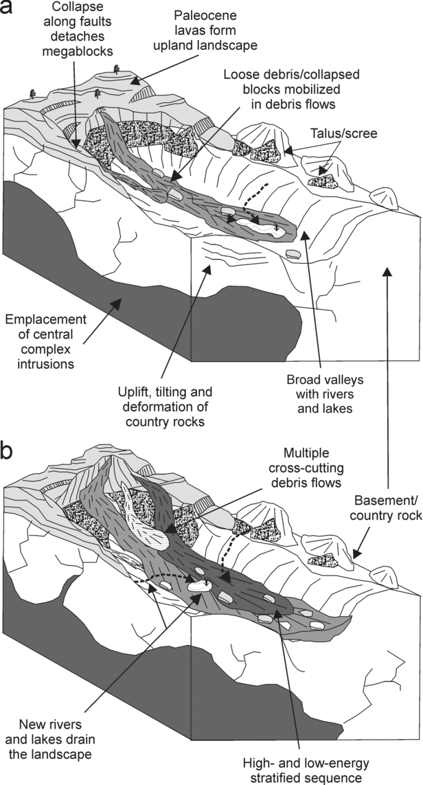
In volcanic settings, loose debris (including soil, regolith and/or weathered bedrock) and collapsed blocks are mobilized downslope in debris flows, often in response to continuing uplift, tectonism and heavy rainfall (Palmer & Neall, Reference Palmer and Neall1991; Smith & Lowe, Reference Smith, Lowe, Fisher and Smith1991). As large blocks are detached, they may be transformed into mixed block and matrix facies downslope, producing a more typical debris flow (e.g. Kessler & Bedard, Reference Kessler and Bedard2000; Reubi & Hernandez, Reference Reubi and Hernandez2000). These combined mechanisms most likely generated the bulk of the debris in the Ardnamurchan and Mull conglomerates and breccias (D. J. Brown, unpub. Ph.D. thesis, Univ. Glasgow, 2003; Brown & Bell, Reference Brown and Bell2006, Reference Brown and Bell2007).
As debris flows move downslope, they can be ‘bulked up’ by entrained material from the land surface, with the largest clasts being pushed to the heads of flows (Takahashi, Reference Takahashi1978). Scott et al. (Reference Scott, Vallance, Kerle, Macías, Strauch and Devoli2005) note an initial rockslide–debris avalanche at Casita, Nicaragua, which evolved on the flank of the volcano to form a watery debris flood, with a sediment concentration <60% by volume, at the base of the volcano. However, 2.5 km from here the debris flood entrained enough sediment to transform entirely to a debris flow. Similar behaviour was noted in the Electron Mudflow event at Mount Rainier, Washington (Scott, Vallance & Pringle, Reference Scott, Vallance and Pringle1995). In the Ben Hiant and Achateny members of Ardnamurchan, increasingly heterogeneous and rounded clast populations are noted in distal areas (Brown & Bell, Reference Brown and Bell2006, Reference Brown and Bell2007), suggesting such incorporation of weathered, eroded debris into the flows. Locally in the Ben Hiant Member, deposits characteristic of hyperconcentated flow (see Section 6.a; Table 1), and ultimately stream-flow, indicate that some flows were diluted with water, as described in Section 5.d (Pierson & Scott, Reference Pierson and Scott1985; Scott, Reference Scott1988; Best, Reference Best1992; Scott, Vallance & Pringle, Reference Scott, Vallance and Pringle1995; Sohn, Rhee & Kim, Reference Sohn, Rhee and Kim1999; Brown & Bell, Reference Brown and Bell2006, Reference Brown and Bell2007). During periods of quiescence, rivers and streams may drain debris flow fans, and small lakes and/or swamps can develop (Palmer & Neall, Reference Palmer and Neall1991; White & Riggs, Reference White and Riggs2001). Fluvio-lacustrine siltstones and sandstones in the Ben Hiant Member of Ardnamurchan are indicative of such activity.
These events are collectively summarized in Figure 9. The pattern of high- to low-energy sedimentation is repeated several times in the Ardnamurchan deposits, and similar activity may have occurred on Mull. Flow transformations provide a plausible mechanism for the bulking and dilution of the debris involved in these deposits.
Schematic diagram illustrating a generalized interpretation of early sedimentary response to intrusion in the BPIP. (a) Initial uplift; (b) continuing uplift.

7. Caldera collapse
With time, large volcanic structures are thought to have developed in the BPIP. Although little is known of these volcanoes, calderas are thought to have formed on Rum, Mull, Skye and Arran (Fig. 2). Locally, there are difficulties in the interpretation of calderas because: (1) postulated remnants of calderas are preserved as isolated, often poorly exposed, screens between intrusions, leading to difficulties in identifying typical caldera-infill successions, such as collapse breccias and ignimbrites and (2) reliable marker horizons/structural controls to indicate subsidence, as well as structures to accommodate subsidence, such as ring-faults, are rare, absent or very poorly preserved. In many cases in the BPIP, fragmental rocks partially surrounded by broadly annular or ring-shaped intrusions and/or faults have been cited as examples of ‘central block’ or ‘cauldron’ subsidence (Richey, Reference Richey1932; Anderson, Reference Anderson1936). In these models, magma (typically silicic) is intruded in the form of a ‘ring-dyke’, along steep, outwardly dipping fractures that accommodate the subsidence of a central, cylinder-like block. The fractures may either reach the surface, forming a caldera and initiating surface volcanism, or remain sub-surface, as a planar and near-horizontal detachment. In the latter case, fragmental rocks spatially associated with the ring-fractures have often been interpreted as subterranean ‘explosion’ breccias related to gas-induced fracturing (Bailey et al. Reference Bailey, Clough, Wright, Richey and Wilson1924; Bell, Reference Bell1985). Cauldron subsidence and explosion breccia models have been invoked at nearly all the central complexes, but in the last 30 years, challenges to these models have been presented (see reviews, Bell & Williamson, Reference Bell, Williamson and Trewin2002; Donaldson, Troll & Emeleus, Reference Donaldson, Troll and Emeleus2001; Emeleus & Bell, Reference Emeleus and Bell2005).
7.a. Rum
As outlined in Section 6.c, upwelling of magma on Rum led to doming and uplift of country rocks inside a ring-fault system (Emeleus, Reference Emeleus1997). Work on the Rum caldera (Fig. 2c) has focused primarily on an area of rocks called the Northern Marginal Zone (Fig. 2d) located around Coire Dubh in the east of the island (see review, Donaldson, Troll & Emeleus, Reference Donaldson, Troll and Emeleus2001). A suite of similar rocks, called the Southern Mountains Zone (Fig. 2c), is located in the south (Hughes, Reference Hughes1960; Holohan et al. Reference Holohan, Troll, Errington, Donaldson, Nicoll and Emeleus2009, this issue), and this area provides structural evidence for a phase of caldera-forming subsidence along the Main Ring Fault system. At Beinn nan Stac (Fig. 2c), the Main Ring Fault displays inner and outer faults. Here, slivers of Mesozoic strata and basalt of Eigg Lava Field type, are found down-faulted, inside previously uplifted Lewisian gneiss (Smith, Reference Smith1985; Emeleus, Wadsworth & Smith, Reference Emeleus, Wadsworth and Smith1985; Emeleus, Reference Emeleus1997).
7.a.1. Northern Marginal Zone
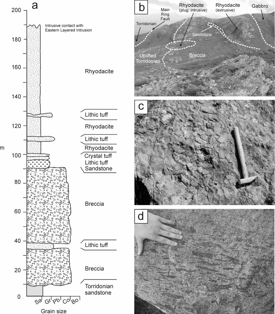
The Northern Marginal Zone contains a ~30–120 m thick sequence of breccias (‘mesobreccias’), tuffs and pebbly sandstones that unconformably overlie uplifted and deformed Torridonian country rocks (Emeleus, Reference Emeleus1997; Troll, Emeleus & Donaldson, Reference Troll, Emeleus and Donaldson2000) (Table 1; Figs 2d, 10a–c). The breccias comprise angular to sub-rounded clasts, 2–55 cm across, of Torridonian country rock and rarer basalt, dolerite and Lewisian gneiss, set in a finely comminuted matrix of Torridonian material (Fig. 10c). The breccias change from clast- to matrix-support up-section, and in places can be subdivided into distinct normally graded packages (~5–15 m thick). Up to three packages of very thin (10–20 cm), laterally discontinuous (up to 100 m), lithic and crystal tuffs are interbedded with the breccias (Fig. 10a). The breccias directly above these units comprise more angular clasts and contain glass shards, lapilli, scoria and crystals reworked from the underlying tuffs. The uppermost breccias of the Northern Marginal Zone sequence grade into a pale-grey or cream sandstone (Fig. 10a, b), which is 1.5 to 6 m thick, and fills a palaeo-topography on the breccias. The breccia sequence is capped by 40–80 m thick sheet-like exposures of grey to black, feldspar–porphyritic rhyodacite (or ‘felsites’) with a well-developed eutaxitic texture defined by fiamme (Fig. 10a, d). The rhyodacite is locally interbedded with lithic tuff and breccia horizons (<2 m thick). Locally, steeply inclined rhyodacite feeder dykes are also present (Fig. 10b), and apparently grade into the sheets (Troll, Emeleus & Donaldson, Reference Troll, Emeleus and Donaldson2000).
(a) Representative log through the Coire Dubh area, Northern Marginal Zone (NMZ), Rum. Redrawn from Troll, Emeleus & Donaldson (Reference Troll, Emeleus and Donaldson2000). (b) Field relationships of Torridonian sandstone, breccia and rhyodacite in the NMZ, Coire Dubh. Redrawn from Troll et al. (Reference Troll, Nicoll, Emeleus and Donaldson2008). (c) Clast-supported breccias from the NMZ, Coire Dubh. Hammer is 30 cm in length. (d) Fiamme in rhyodacite, NMZ, Coire Dubh texture.

In the early part of the 20th century, the breccias and rhyodacites of the Northern Marginal Zone were generally regarded as subterranean explosion breccias (or ‘vent agglomerates’) and sills, respectively (see review, Donaldson, Troll & Emeleus, Reference Donaldson, Troll and Emeleus2001). By the early 1980s, increased knowledge of pyroclastic processes led to re-classification of the rhyodacites as welded ignimbrites, or ‘ash-flow tuffs’ (Williams, Reference Williams1985). Moreover, as structural evidence for subsidence was found in the Southern Mountains Zone, an intra-caldera setting for formation of the rhyodacite sheets and breccias was proposed (Smith, Reference Smith1985; Emeleus, Wadsworth & Smith, Reference Emeleus, Wadsworth and Smith1985; Bell & Emeleus, Reference Bell, Emeleus, Morton and Parson1988; Emeleus, Reference Emeleus1997; Troll, Emeleus & Donaldson, Reference Troll, Emeleus and Donaldson2000). The breccias were thus interpreted as the products of the collapse of unstable caldera walls, and inwards slumping and sliding of debris in large mass flow events (cf. Nelson et al. Reference Nelson, Bacon, Robinson, Adam, Platt Bradbury, Barber, Schwartz and Vagenas1994; Branney, Reference Branney1995; Troll, Emeleus & Donaldson, Reference Troll, Emeleus and Donaldson2000; Bacon et al. Reference Bacon, Gardner, Mayer, Buktenica, Dartnell, Ramsay and Robinson2002). The thick pale-grey sandstone unit was deposited from washed-out fines from the underlying breccias and is thought to represent a time-gap between phases of caldera collapse (Troll, Emeleus & Donaldson, Reference Troll, Emeleus and Donaldson2000).
7.a.2. Southern Mountains Zone
Similar breccias and rhyodacites, also originally interpreted as explosion breccias and intrusions (Hughes, Reference Hughes1960), are exposed in the Southern Mountains Zone (Fig. 2c), but despite their spectacular appearance, they have received less attention due to their remote location and the difficult terrain. These rocks are described more fully in this volume by Holohan et al. (Reference Holohan, Troll, Errington, Donaldson, Nicoll and Emeleus2009, this issue) and are also re-classified as sedimentary breccias and ignimbrites formed by caldera collapse. Rather than a simple sequence of breccias capped by ignimbrite as in the Northern Marginal Zone, the much more heterolithic breccias are interbedded with at least two ignimbrites, which in places may be over 100 m thick. The breccias are clast- to matrix-supported and poorly sorted with clasts up to 2 m across. In places, crude metre-scale bedding, defined by alternating feldspathic sandstone-rich (pink) breccias and gneiss-rich (light-grey) breccias, is recognized. Locally, the breccia grades up into pebbly sandstone and/or tuffaceous sandstones bearing accretionary lapilli. The rhyodacites form sheets ~25–100 m thick, display gradational to sharp concordant contacts with the breccias, locally exhibit both basal lithic tuffs (<5 m thick) and graded fiamme swarms, and are moderately to densely welded.
7.b. Mull
The Mull Central Complex includes three successive, but partially overlapping, centres of activity: Centre 1 (Glen More), Centre 2 (Beinn Chaisgidle) and Centre 3 (Loch Ba) (Fig. 2b). Several features of Centres 1 and 3 have been related to calderas, and these have been termed the Early and Late calderas, respectively (Bailey et al. Reference Bailey, Clough, Wright, Richey and Wilson1924).
7.b.1. The Early Caldera
The ‘Early Caldera’ contains remnants of pillowed basaltic lavas derived from the youngest part of the Mull lava sequence (the Central Lava Formation/Group), as well as various breccias and felsites (silicic sheets) (Fig. 2b). This area is thought to represent the early stages of a ring-fault-controlled caldera (periodically filled by lakes), which progressively subsided to accommodate the late-stage lavas (Bailey et al. Reference Bailey, Clough, Wright, Richey and Wilson1924). The trace of the ring-fault, thought to define the caldera margin, is often obscured by masses of the breccia, interpreted as ‘explosion breccias’, and ‘felsites’ (silicic) of unclear geometry and origin (Bailey et al. Reference Bailey, Clough, Wright, Richey and Wilson1924). Bailey et al. (Reference Bailey, Clough, Wright, Richey and Wilson1924) argued that evidence for subsidence is provided by: (1) the presence of the youngest Paleocene lavas within the caldera, and exposures of Moine schist, Mesozoic sedimentary rocks and older Paleocene lavas, at the same elevation outside the caldera and (2) the general absence of clasts of Moine schist from breccias inside the caldera compared to those outside, indicating that the basement (Moine) lies at a deeper structural level beneath the caldera, and that explosive brecciation occurred at a relatively shallow level in the crust.
The breccias have not been studied in detail since these interpretations were made, however. Superficially they resemble mass flow deposits seen at Coire Mor and Barachandroman (Section 6.b) and Ardnamurchan (Section 6.a), but also caldera collapse breccias at Rum (Section 7.a). Bailey et al. (Reference Bailey, Clough, Wright, Richey and Wilson1924) noted that, in places, the breccias are interbedded with ‘finely bedded sediments such as might have been deposited in local pools of water’, indicating hiatuses in deposition and fluvio-lacustrine activity. The breccias most likely represent sedimentary deposits predominantly of mass flow origin, linked to caldera collapse (with minor interbedded fluvio-lacustrine units), but further study is clearly required.
7.b.2. The Late Caldera
The ‘Late Caldera’ is delimited by the Loch Ba Ring-dyke (‘felsite’) (Fig. 2c), a steeply inclined intrusion of partially fragmented, mixed and mingled, mafic and silicic magmas (Bailey et al. Reference Bailey, Clough, Wright, Richey and Wilson1924; Sparks, Reference Sparks1988). Inside the ring-dyke is a series of volcaniclastic breccias and sandstones (D. J. Brown, unpub. Ph.D. thesis, Univ. Glasgow, 2003), and basaltic lavas. These lavas are interpreted as part of the Central Lava Formation (Bailey et al. Reference Bailey, Clough, Wright, Richey and Wilson1924), whereas those outside the ring-dyke are from the older Plateau Formation, and this relationship was interpreted as evidence for subsidence (Bailey et al. Reference Bailey, Clough, Wright, Richey and Wilson1924). The breccias are reddish-brown to grey-brown, relatively poorly sorted, clast- to matrix-supported, and set in a sand-grade basaltic matrix (Table 1). Clasts range in size from 1–2 cm up to 50 cm across, with less common larger blocks up to 1 m, and are typically sub-angular to sub-rounded, with rarer rounded blocks. Clasts are predominantly basalt with some Moine schist, Paleocene granite, and rarer blocks of Mesozoic sandstone. Locally, the breccias are dominated by basalt blocks up to 10 m across. The breccias are bedded, fill depressions in underlying units, and locally fine upwards into sandstone. No trap topography is observed in the ‘lavas’ interior to the ring-dyke, and in places the heavily fractured and shattered basalt grades into breccia (D. J. Brown, unpub. Ph.D. thesis, Univ. Glasgow, 2003). The breccias are interpreted as high-energy mass flow deposits, most likely formed by collapse of caldera wall material, in particular the Paleocene Plateau Formation lavas (D. J. Brown, unpub. Ph.D. thesis, Univ. Glasgow, 2003). The breccias are also associated with locally flow-banded, heavily altered, poorly exposed and understood ‘felsites’, which have been interpreted as rhyolite domes (Preston, Reference Preston and Sutherland1982), although they appear to represent rheomorphic ignimbrites.
7.c. Skye
The Skye Central Complex includes four successive, but partially overlapping, centres of activity: (1) the Cuillin Centre, (2) the Srath na Creitheach Centre, (3) the Western Red Hills Centre and (4) the Eastern Red Hills Centre. Two large breccia outcrops are associated with these centres: the Srath na Creitheach breccias are intruded by the Srath na Creitheach Centre, and the Kilchrist breccias are intruded by the Eastern Red Hills Centre (Fig. 2e).
7.c.1. Srath na Creitheach
These volcaniclastic breccias and sandstones form a ~450 m thick sequence and crop out over an area of ~2 × 1.5 km. They are located to the east of, and were formed after, the Cuillin Centre of the Skye Central Complex (Fig. 2e), as large amounts of gabbro from this centre are found as clasts in the breccia. To the north and east they are cut by granites of the later Srath na Creitheach Centre, whereas the southern margin is interpreted as a ring-fault, based on the truncation of the breccias and a zone of arcuate fracturing in the gabbros at the margin (Jassim & Gass, Reference Jassim and Gass1970). The breccias (Table 1) are dark grey, poorly sorted, clast- to matrix-supported deposits with sub-rounded to sub-angular clasts ranging in size from 2 cm to 50 cm, typically of basalt (thought to be of Skye Lava Field origin), dolerite and gabbro with rarer peridotite and trachyte, set in a matrix of fine-grained, similar, comminuted material (Jassim & Gass, Reference Jassim and Gass1970; D. J. Brown, unpub. Ph.D. thesis, Univ. Glasgow, 2003). Intercalated with the breccias are two laminated, well-bedded, gently dipping (~10°), and discontinuous (up to 200 m across) volcaniclastic sandstone layers or ‘rafts’ that range from 30 cm to 2 m thick (Table 1). The laminae form prominent alternating dark and light bands, and range from planar to highly contorted. Clasts of similar sandstone are found in the overlying breccia. Primary pyroclastic material is absent from the breccias and sandstones. The most distinctive feature of these deposits is the presence of several large slabs of bytownite troctolite (gabbro), 40–900 m across, of Cuillin Centre type (Jassim & Gass, Reference Jassim and Gass1970). New observations indicate that the base of these slabs comprises brecciated gabbro, with a ‘jigsaw-fit’ of clasts, which passes upwards into fractured, then massive gabbro (D. J. Brown, unpub. Ph.D. thesis, Univ. Glasgow, 2003).
Jassim & Gass (Reference Jassim and Gass1970) named these rocks the ‘Loch na Creitheach Vent.’ They suggested the breccias, or ‘agglomerates’, were fragmented by a gaseous rather than liquid explosive agent, due to the absence of ‘live pyroclastic debris’, and subsequent collapse of the vent walls (including the gabbro slabs), although evidence for the gaseous agent (e.g. intense vesiculation of the matrix) is vague. Jassim & Gass (Reference Jassim and Gass1970) interpreted the sandstones or ‘tuffs’ as sub-aerial pyroclastic deposits. The entire vent structure is then thought to have subsided some 750–1000 m along marginal ring fractures, although no clear structural evidence for subsidence is preserved. Ross et al. (Reference Ross, Ukstins Peate, McClintock, Xu, Skilling, White and Houghton2005) suggested that the Srath na Creitheach breccias resemble phreatomagmatic, diatreme-like vent-filling deposits at Coombs Hills in the Ferrar Province of Antarctica (White & McClintock, Reference White and McClintock2001; McClintock & White, Reference McClintock and White2006), but did not explain why. Although this explanation accounts for the arcuate geometry of the Srath na Creitheach ‘vent’ and the presence of large slabs of wall rock and volcaniclastic debris, the absence of primary pyroclastic material remains problematic. Evidence of comparable materials to those found in the Coombs Hills deposits (e.g. peperites, hyaloclastites, quenched juvenile fragments in tuff) and sub-vertical tuff-breccia zones (McClintock & White, Reference McClintock and White2006) are also absent, although erosion and intrusion may have removed or obscured such products. Similarly, phreatic or hydrothermal eruptions could account for the lack of juvenile clasts.
Regardless of the final modes of fragmentation, transportation and deposition of these enigmatic rocks, it is clear from the presence of large slabs and other coarse, clastic material, that catastrophic collapse events were implicated in their formation. The gabbro slabs, with their brecciated bases forming a ‘jigsaw-fit’ of clasts, are typical of megablocks in debris avalanche deposits (Smith & Lowe, Reference Smith, Lowe, Fisher and Smith1991; Yarnold, Reference Yarnold1993). We suggest that the Srath na Creitheach deposits were formed by gravitational collapse, perhaps from some sort of crater wall system (small caldera/vent?) (Nelson et al. Reference Nelson, Bacon, Robinson, Adam, Platt Bradbury, Barber, Schwartz and Vagenas1994; Branney, Reference Branney1995; Bacon et al. Reference Bacon, Gardner, Mayer, Buktenica, Dartnell, Ramsay and Robinson2002) and minor reworking by debris flow/slide. The sandstones represent periods of lower-energy sedimentation (small streams and lakes) on the debris fan surfaces (D. J. Brown, unpub. Ph.D. thesis, Univ. Glasgow, 2003).
7.c.2. Kilchrist
Located in the eastern part of the Skye Central Complex, these volcaniclastic rocks crop out over an area of ~4.0 × 1.2 km, are up to ~200 m thick, and intruded by granites of the Eastern Red Hills Centre (Fig. 2e). The dominant heterolithic breccias are poorly sorted and clast- to matrix-supported, with sub-angular to rounded clasts (up to 2 m across) set in a comminuted matrix of sand-grade material (Table 1). Clasts include various pre-Paleocene country rocks, Paleocene basalt, dolerite, gabbro, ignimbrite and granite, together with fragments of older volcaniclastic breccia (Bell, Reference Bell1985; Bell & Harris, Reference Bell and Harris1986). Intercalated with the breccias are various thin volcaniclastic sandstones and a hyaloclastite breccia, and in places the breccias and sandstones display reddened weathering profiles (Bell, Reference Bell1985; Bell & Harris, Reference Bell and Harris1986). The breccias are generally unstratified, although some weakly defined bedding, channels and grading have been identified (D. J. Brown, unpub. Ph.D. thesis, Univ. Glasgow, 2003). Various poorly exposed ignimbrites (up to 20 m thick) displaying fiamme with aspect ratios of 20:1 or more, are intercalated with the breccias, rarely with gradational boundaries between the two. Some of the ignimbrites are strongly rheomorphic and display open, inclined, recumbent and ptygmatic folds, with wavelengths up to 10 cm (S. Drake, unpub. data), although no consistent flow direction can be determined. Locally, thin, poorly exposed, fall deposits (<1 m thick and <5 m across) are intercalated with the breccias, rarely with gradational boundaries between the two. The Kilchrist sequence is partly surrounded by mixed-magma intrusions called the ‘Kilchrist Hybrids’, which locally display steep, outward-dipping contacts against country rocks.
The Kilchrist Hybrids were interpreted as a ring-dyke (Bell, Reference Bell1983, Reference Bell1985), the emplacement of which was thought to be contemporaneous with subsidence of a central block of country rock (cauldron subsidence) (Bell, Reference Bell1983). The fragmental rocks were interpreted as subterranean pyroclastic (vent?) breccias associated with the ring-faults, which were periodically exposed to the surface and subject to weathering and/or reworking (Bell, Reference Bell1985). However, the poorly sorted nature and large clast size of some of the breccias, together with the absence of juvenile pyroclastic material, are indicative of debris flow deposition, locally interspersed with low-energy reworking of fines from debris flow surfaces (D. J. Brown, unpub. Ph.D. thesis, Univ. Glasgow, 2003). Evidence for contemporaneous volcanism and sedimentation is provided by the presence of airfall tuffs and ignimbrites intercalated with the breccias, and gradations between these units. We suggest the Kilchrist sequence formed during caldera collapse, with the breccias the products of the break-up of crater walls (cf. Nelson et al. Reference Nelson, Bacon, Robinson, Adam, Platt Bradbury, Barber, Schwartz and Vagenas1994; Branney, Reference Branney1995; Bacon et al. Reference Bacon, Gardner, Mayer, Buktenica, Dartnell, Ramsay and Robinson2002).
7.d. Arran
The Isle of Arran comprises Neoproterozoic metamorphic rocks and Palaeozoic sedimentary rocks that are intruded by the Paleocene North Arran Granite, the Central Ring Complex and various sills (Tyrell, Reference Tyrrell1928). How the North Arran Granite relates to the Central Ring Complex is unclear. The Central Ring Complex is ~5 km across and contains lavas, ‘felsites’ and breccias (‘agglomerates’) surrounded by arcuate ring-faults and ring-intrusions (granitic) (Fig. 2f), and has long been interpreted as a caldera (King, Reference King1954). The current level of erosion means that the Central Ring Complex arguably preserves the most complete picture of a caldera within the BPIP; however, poor exposure has limited its study.
Laterally discontinuous exposures of poorly sorted breccia, or ‘agglomerate’ (and rarer well-sorted conglomerate), up to 10 m thick and 50 m across, within the Central Ring Complex contain sub-angular to rounded fragments of various lithologies, including Paleocene igneous rocks, together with Permian and Mesozoic sedimentary rocks, all set in a matrix of similar comminuted material (Table 1). Bedding relationships are obscured. The breccias include blocks of local country rocks tens of metres, and rarely hundreds of metres, across. Locally, such masses of Permian sandstone within the Central Ring Complex are juxtaposed against Devonian Old Red Sandstone country rock (King, Reference King1954). Sheet-like bodies of ‘felsite’ up to 30 m thick are locally intercalated with the breccias and typically comprise ‘flow banded’ plagioclase–porphyritic rhyolite and dacite (King, Reference King1954). The breccias (‘agglomerates’) and felsites are cut by three small, distinct, centres comprising basaltic, andesitic and dacitic lavas and breccias.
The main breccias were originally interpreted as explosive ‘vent agglomerates’, although the option of other unspecified processes of prolonged attrition to explain their formation was also considered (King, Reference King1954). The juxtaposition of Permian sandstone within the caldera against Devonian country rock outside provides evidence for subsidence along the caldera-bounding ring-fault (King, Reference King1954). The presence of clasts and blocks of Jurassic and Cretaceous sedimentary rocks and Paleocene basalt lavas within the breccias also indicates the removal of a substantial country-rock cover now absent from Arran. Later, Bell & Emeleus (Reference Bell, Emeleus, Morton and Parson1988) argued that the breccias were formed from erosion and collapse of the unstable, topographically elevated caldera walls (e.g. Nelson et al. Reference Nelson, Bacon, Robinson, Adam, Platt Bradbury, Barber, Schwartz and Vagenas1994; Branney, Reference Branney1995; Bacon et al. Reference Bacon, Gardner, Mayer, Buktenica, Dartnell, Ramsay and Robinson2002). The felsites were not described in detail, although King (Reference King1954) suggested they were intrusive. The three smaller distinct centres are interpreted as late-stage or post-collapse cones, comprising lavas and breccias, which developed on the caldera floor (King, Reference King1954).
Recent observations in an ongoing study of the Central Ring Complex (D. J. Brown, K. J. Dobson & K. M. Goodenough, unpub. data) agree with Bell & Emeleus (Reference Bell, Emeleus, Morton and Parson1988) in suggesting that the majority of the breccias are formed by sedimentary processes. The presence of large blocks of country rock and clast-supported breccias are indicative of massive collapses of caldera wall and/or floor, together with talus accumulations, while poorly sorted, variably clast- to matrix-supported breccias are consistent with debris flow activity. The ‘felsites’ are re-interpreted here as ignimbrites and comprise tuffs, lapilli-tuffs and lithic breccia (D. J. Brown, K. J. Dobson & K. M. Goodenough, unpub. data).
7.e. Process
Large exposures of volcaniclastic rocks in the Mull and Arran central complexes have long been linked to caldera collapse events (e.g. Bailey et al. Reference Bailey, Clough, Wright, Richey and Wilson1924; King, Reference King1954). In other centres, such as Rum and Skye, recognition of the role of caldera collapse in the generation of volcaniclastic rocks has stemmed from more recent re-evaluations and discoveries (e.g. Troll, Emeleus & Donaldson, Reference Troll, Emeleus and Donaldson2000). Although evidence of caldera/cauldron subsidence in the BPIP is incomplete at many localities, and new perspectives on ‘ring-dyke’ emplacement have been proposed at others (e.g. the re-interpretation of ring-dykes as lopoliths: O'Driscoll et al. Reference O'Driscoll, Troll, Reavy and Turner2006), such re-evaluations have led to increased awareness of the potential for caldera collapse to generate many of the enigmatic exposures of breccias and ‘felsites’ in the BPIP. Furthermore, caldera subsidence provides a structural mechanism for the juxtaposition of surface-level sedimentary and pyroclastic rocks against deep level intrusions, as seen in the BPIP.
Due to the current erosion and exposure levels in the BPIP, the exact nature of the proposed caldera structures is still uncertain. Possibilities include: (1) low-lying calderas formed by rapid, multiple collapse events and voluminous ignimbrite eruption (e.g. Taupo, New Zealand: Wilson et al. Reference Wilson, Houghton, McWilliams, Lanphere, Weaver and Briggs1995; La Garita, Colorado: Lipman, Dungan & Bachmann, Reference Lipman, Dungan and Bachmann1997; Long Valley, California: Wilson & Hildreth, Reference Wilson and Hildreth1997), (2) calderas at stratovolcanoes formed by collapse of domes and stratocones (e.g. Karakatau: Self & Rampino, Reference Self and Rampino1981; Mt. Mazama/Crater Lake: Bacon, Reference Bacon1983; Santorini: Druitt et al. Reference Druitt, Edwards, Mellors, Pyle, Sparks, Lanphere, Davies and Barriero1999) and (3) calderas at shield volcanoes formed by tumescence, possible flank eruptions and drawdown of magma (e.g. Hawai'i: Walker, Reference Walker1988), or basaltic explosive activity (e.g. Masaya, Nicaragua: Rymer et al. Reference Rymer, van Wyk de Vries, Stix and Williams-Jones1998).
In the BPIP, the postulated Arran, Mull and Rum calderas are all >5 km across, suggesting they were major collapse structures. On Arran, Kilchrist and Rum, the breccias are interbedded with silicic ignimbrite sheets, and within ring-dykes/ring-intrusions, indicating syn-eruptive caldera subsidence. The relationship of the breccias with the ignimbrites is variable, but the volumes of material involved and composition of the pyroclastic rocks suggest the possibility of the type 1 and 2 calderas discussed above. The breccias typically form discrete units from the ignimbrites, rather than tuffaceous lithic breccia zones within ignimbrites (cf. this study; Moore & Kokelaar, Reference Moore and Kokelaar1998; Branney & Kokelaar, Reference Branney and Kokelaar2002). The Early and Late calderas of Mull have not been described in detail but they contain breccias interbedded with ‘felsite’ sheets (probable ignimbrites) and lavas, within ring-dyke/ring-fault structures, consistent with syn-eruptive caldera subsidence.
The absence of pyroclastic activity at a caldera suggests withdrawal of magma and collapse without associated eruption, as observed, for example, at the basaltic Miyakejima caldera, Japan, in 2000 (Geshi et al. Reference Geshi, Shimano, Chiba and Nakada2002). In this example, collapse was triggered by lateral withdrawal of magma from the volcano, and no major eruption occurred from the summit caldera, which subsided by up to 1.6 to 2.1 km. A similar process occurred at the andesitic–rhyolitic Mount Katmai/Novarupta system, Alaska, in 1912 (Hildreth, Reference Hildreth1991). Pyroclastic material is absent from the breccias at Srath na Creitheach on Skye, and they form part of a smaller collapse structure (~2 km across). While erosion and/or intrusion may have removed part of the stratigraphy, these breccias may have formed in a similar way.
Intra-caldera megabreccia and mesobreccia sequences described by Lipman (Reference Lipman1976) are dominated by coarse, poorly sorted breccias, whose textures resemble debris flow, slide and avalanche units (Glicken, Reference Glicken, Fisher and Smith1991; Yarnold, Reference Yarnold1993). These mass flow events were most likely triggered by gravitational collapse and slumping of topographically elevated caldera/crater/vent walls, although contemporaneous volcanism, faulting, seismicity, intrusion and rainfall may also be implicated. Loose debris, including recently collapsed material, talus, and detritus on the caldera floor is then mobilized in debris flows (Miura & Tamai, Reference Miura and Tamai1998; Moore & Kokelaar, Reference Moore and Kokelaar1998; Bacon et al. Reference Bacon, Gardner, Mayer, Buktenica, Dartnell, Ramsay and Robinson2002). Such collapse mechanisms and products (e.g. coarse breccias, megablocks) can be recognized throughout the BPIP intra-caldera breccias (Fig. 11).
Schematic diagram illustrating a generalized interpretation of sedimentary processes during caldera collapse events in the BPIP. Intra-caldera ignimbrites are omitted to elucidate the sedimentary events.
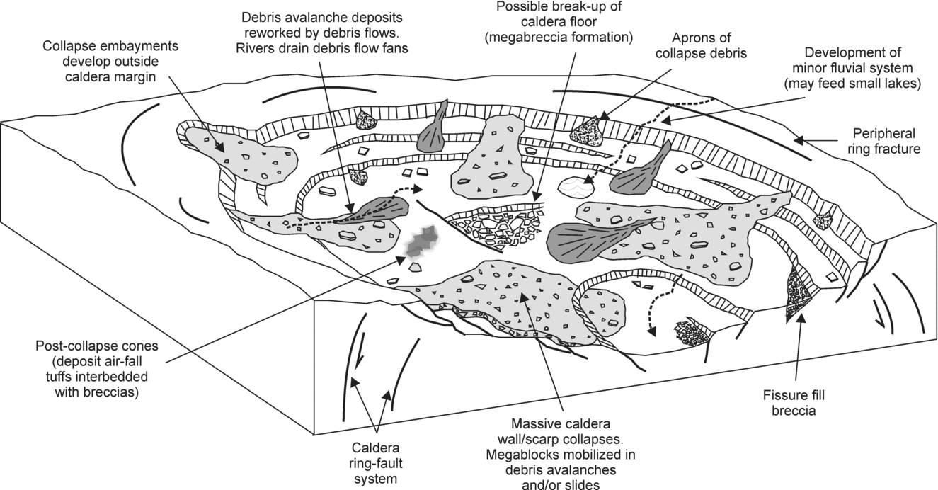
As caldera walls collapse, large blocks of country rock become heavily fractured and grade into clast-supported breccia, features typical of debris avalanche megablocks (Glicken, Reference Glicken, Fisher and Smith1991; Yarnold, Reference Yarnold1993; Kessler & Bedard, Reference Kessler and Bedard2000; Reubi & Hernandez, Reference Reubi and Hernandez2000), although some may simply represent pieces of subsided/segmented caldera floor (Miura & Tamai, Reference Miura and Tamai1998) (Fig. 11). Large blocks of country rock and Paleocene lava preserved in the BPIP breccias, for example, on Arran and Skye, display similar textures and geometries. The location of proposed collapse avalanches would have been controlled by the timing and position of the fault scarps (e.g. piecemeal caldera collapse: Lipman, Reference Lipman1997).
‘Quiescent’ periods following, and between pulses of, caldera collapse can be marked by fluvio-lacustrine sedimentation (e.g. Moore & Kokelaar, Reference Moore and Kokelaar1998; Kokelaar, Raine & Branney, Reference Kokelaar, Raine and Branney2007). On Rum, such fluvial sandstones are present, and packages of breccia become less angular up-section, indicating reworking of debris by background sedimentary processes (Troll, Emeleus & Donaldson, Reference Troll, Emeleus and Donaldson2000).
The caldera collapse events envisaged in the BPIP are collectively illustrated in Figure 11. In summary, the BPIP volcanoes appear to have been subject to multiple periods of syn-eruptive collapse, although in some cases, lateral withdrawal of magma may have resulted in collapse without eruption. Collapse involved the break-up of caldera walls and/or floor, and the transportation of material in debris avalanches, flows and slides, interspersed by fluvio-lacustrine sedimentation.
8. Comparison of mass wasting deposits
Mass wasting deposits have been recognized in the BPIP in three main settings: (1) interbedded with the lava fields, (2) at the margins of central complexes (intrusion-induced uplift) and (3) within central complexes (intra-caldera). As discussed in Sections 5–7, many of these breccias and conglomerates are formed by similar processes (e.g. debris flow, debris avalanche); however, the deposits are extremely variable in terms of area and volume, reflecting the energy involved and the nature (size, relationship to volcano-tectonism, etc.) of the failure events. These characteristic features are summarized in Table 2. The products of post-volcano denudation and exhumation, discussed in Section 9 below, are typically found interbedded with the lava fields, reflecting the overlapping nature of the chronology of the BPIP.
Although evidence for the exact nature of the volcanic edifices associated with the BPIP has been removed by erosion, the volcaniclastic rocks described in Section 7 are undoubtedly volcano-proximal deposits, given their position within the central complexes and, in some examples, association with thick pyroclastic units and confinement within ring-dykes/faults. The majority of deposits in these areas are breccias, their angular clasts indicating that the incorporated debris was penecontemporaneously fragmented and mass flow units had not travelled far, most likely reflecting their confinement within a caldera. This is in contrast to the central complex marginal deposits described in Section 6. Many of these units, although initiated in upland areas, were transported over relatively large distances (up to 10 km) and deposited more distally in a lowland landscape with broad valleys well drained by rivers. These conditions are reflected by their more rounded nature and the presence of interbedded fluvio-lacustrine units. None the less, in both cases, the presence of individual beds at least 1 km in length and tens of metres thick demonstrates the overall vast volume of material transported during these catastrophic events. By contrast, the conglomerates and breccias interbedded with the lava fields, and described in Section 5, are much smaller volume deposits, reflecting relatively minor hillslope failures.
One further complication in distinguishing mass wasting deposits produced by intrusion-induced uplift and caldera collapse exists. Where intrusion-induced uplift is followed by caldera collapse and the effects of both volcano-tectonic processes are superimposed (e.g. on Rum), we can anticipate yet further complexity in the resultant sedimentary rocks. Indeed, much of the debris in the postulated caldera successions may have been generated by earlier uplift events. Post-caldera resurgence and/or regional uplift events may also have contributed material to these successions. To understand these complexities remains an exciting challenge for workers in the BPIP.
9. Post-volcano denudation and exhumation of central complexes
The volcanoes of the BPIP, from initiation to decay, were short-lived phenomena, with the best example provided by the Rum Central Complex. Chambers, Pringle & Parrish (Reference Chambers and Pringle2005) suggested that within a period of 0.92 Ma, the Eigg Lava Field was erupted, the Rum central volcano developed and was unroofed, and the Canna Lava Formation (of the Skye Lava Field) was erupted. Evidence for this unroofing is provided by the presence of clasts of Rum Central Complex material (e.g. granite, rhyodacite, troctolite and gabbro) within conglomerates of the Skye Lava Field on: (1) NW Rum (Emeleus, Reference Emeleus1985, Reference Emeleus1997), (2) Canna (Emeleus, Reference Emeleus1973) and (3) Skye (Meighan et al. Reference Meighan, Hutchison, Williamson and MacIntyre1981; Williamson & Bell, Reference Williamson and Bell1994). This relationship is particularly well demonstrated by the lavas and conglomerates of NW Rum (Canna Lava Formation), which, in places, rest unconformably on and fill palaeo-valleys in the Western Granite of the Rum Central Complex (Fig. 2c). During an interval of 0.53 Ma, the age difference between the formation of the layered peridotites of the Rum Central Complex (60.53±0.04 Ma; U–Pb: Hamilton et al. Reference Hamilton, Pearson, Thompson, Kelley and Emeleus1998) and lavas of the Canna Lava Formation (60.00±0.23 Ma; Ar–Ar: Chambers, Pringle & Parrish, Reference Chambers, Pringle and Parrish2005), approximately 1 km of rock cover is thought to have been lost from the top of the Rum central volcano (Emeleus, Reference Emeleus and Craig1983), and therefore, an erosion rate of 1.8 mm per year can be calculated. This figure is comparable with the rapid erosion rates observed in the Himalayas (Burbank et al. Reference Burbank, Leland, Fielding, Anderson, Brozovic, Reid and Duncan1996), where fluvial incision and catastrophic landslides are the dominant agents of geomorphological change. The conglomerates on Rum, Canna and Skye were deposited by fast-flowing rivers and/or debris flows, typically within steep-sided channels or valley. Rapid uplift and construction of the central volcanoes, together with the warm and wet Paleocene climate, provided the topographical gradients and environmental conditions required to facilitate such rapid erosion (Fig. 12). Erosion of the central complexes may have been aided by large, outward-directed landslides, although no evidence of these remains (the examples of such mass wasting events cited from Ardnamurchan and Mull, described in Section 6, are specifically related to intrusion of the central complex). Elsewhere in the BPIP, exhumation rates are not so well constrained; however, we anticipate similar forms and rates of post-volcano erosion.
Schematic diagram illustrating a generalized interpretation of sedimentary processes involved in the denudation and exhumation of central complexes of the BPIP.

10. Future work
The ancient volcanoes of the BPIP have a long history of research, and through detailed study of their intrusive and extrusive products, a comprehensive picture of their evolution has been developed. As a result of the current level of erosion, there has been an inevitable focus on the intrusive central complexes and the extrusive lava fields of the BPIP, and this has led to difficulties in our understanding of the volcanoes thought to dominate the landscape. Due to these challenges, the ancient edifices are often ‘forgotten’, or our knowledge is based on supposition. However, as sedimentary and volcano-tectonic processes continue to be recognized in the BPIP, they afford an excellent opportunity to resolve the complex history of these ancient volcanoes. The re-interpretation of ‘agglomerates’ or ‘explosion breccias’ in the central complexes as sedimentary deposits related to caldera and/or (intrusion-induced) sector collapse, and of ‘felsites’ as ignimbrites, is a recent and ongoing process. These rocks in particular provide a tantalizing glimpse into the ancient volcanoes, and with the benefit of modern sedimentological and physical volcanological knowledge, they can be compared and contrasted with processes observed at active or recent volcanoes. We suggest that further work is required on the central complexes, their ‘calderas’ and marginal deposits. Despite the challenges of erosion, exposure and the Scottish weather, a priority must be the continued detailed mapping and logging of these centres. Future field investigations might be complemented by application of techniques such as Anisotropy of Magnetic Susceptibility, to study, for example, ignimbrite flow directions and ‘ring-dyke’ emplacement (e.g. Ort et al. Reference Ort, Orsi, Pappalardo and Fisher2003; O'Driscoll et al. Reference O'Driscoll, Troll, Reavy and Turner2006; Stevenson et al. Reference Stevenson, Owens, Hutton, Hood and Meighan2007, Reference Stevenson, O'Driscoll, Holohan, Couchman, Reavy, Andrews, Thomson and Petford2008). Isotopic fingerprinting of ‘exotic’ pyroclastic deposits, or igneous clasts within sedimentary deposits, may help to trace their centre of origin, reconstruct drainage pathways, identify tectonic controls (e.g. intrusion-induced uplift; subsidence), and improve the chronology of the Province (together with improved radiometric dating techniques). In the case of the lava fields, we suggest that more detailed analysis of the sedimentary units, particularly in terms of their litho- and biostratigraphy, is required.
11. Conclusions
This study summarizes and illustrates the important contribution of sedimentary and volcano-tectonic processes in the development of the BPIP. These processes had a significant impact on the palaeo-landscape, and their resultant deposits provide important environmental, geographical and stratigraphical information that has helped elucidate the spatial and temporal evolution of the BPIP lava fields and central complexes.
The early part of the BPIP was dominated by the eruption of flood basalt lavas, which were emplaced into broad valleys/basins. Sedimentary rocks are typically found at or near the base of the lava piles, and are also interbedded throughout the sequences. They consist of relatively thin sequences of conglomerates, sandstones, siltstones and coals. Coarse conglomerates were deposited either as talus or alluvial fan accumulations on steep valley slopes, or by minor debris flows in well-defined channels. Montane and upland areas were colonized by conifer and Taxodiaceae trees. Fluviatile conglomerates and sandstones demonstrate that fast-flowing rivers and streams drained the landscape and locally these were confined to channels on alluvial and debris fan surfaces. Downstream, braided rivers (with riparian communities) developed and minor channels migrated across the floodplain, or were abandoned as current activity waned. In valley floors, mudstones were deposited in well-vegetated small lakes, swamps and overbank pools, and locally thin coals formed. These sedimentary cycles repeated, although later in the evolution of the lava fields, sedimentary deposits are less common and were replaced by palaeosols, whose formation was enhanced by the warm and wet Paleocene climate. The picture that emerges is one of voluminous lavas accumulating in broad valleys/basins that were subject to local and/or regional tectonic controls, and that were occupied by localized lakes/swamps and river systems, punctuated by alluvial debris fans.
Intrusion of the central complexes led to uplift of the landscape, and in places catastrophic mass wasting events occurred, leading to the break-up of the lava fields and possible collapses around the now-developing volcanoes. Triggered by deformation induced by intrusion, coupled with heavy rainfall, large blocks of ‘country rock’ were detached from upland areas, and mobilized downslope in debris flows/avalanches. These catastrophic mass wasting events would have carved out large scars on the Paleocene landscape. Flow transformations were responsible for the bulking (incorporation of surface detritus) and dilution of flows (addition of water). Multiple collapse events occurred, but during periods of quiescence, small rivers and lakes drained the debris fans.
Despite sustained erosion and disintegration of material from the uplifting landscape, the volcanoes of the BPIP continued to grow, until some collapsed in on themselves to form large calderas. Blocks of country rock collapsed from topographically elevated caldera walls, and these materials, together with talus and other surface debris, were mobilized in large debris flows, slides or avalanches. These processes continued as the caldera floor continued to subside and segment, typically synchronous with eruption and deposition of ignimbrite.
Gradually volcanic activity in the BPIP ceased. The first extinct edifices were rapidly stripped down by erosion until the shallow intrusive hearths of the volcanoes were exhumed. Fast-flowing rivers and high-energy debris flows transported clasts of this material to distant basins, where volcanism was in its infancy. This pattern repeated throughout the Province until all volcanism ceased and erosion was left to carve out the dramatic natural laboratory we see today.
Acknowledgements
Henry Emeleus, Ian Williamson, Dave Jolley, Val Troll, Simon Drake, Simon Passey, Graeme Nicoll, Kate Dobson, Kathryn Goodenough, Brian O'Driscoll, Carl Stevenson and John Faithfull are thanked for their insightful discussion on sedimentary and volcano-tectonic processes in the BPIP. We would particularly like to thank Henry Emeleus for his time in the field and for sharing his knowledge of the BPIP. Simon Drake, Kate Dobson and Kathryn Goodenough are gratefully acknowledged for sharing unpublished data from Skye and Arran. Vern Manville and Sharon Allen are thanked for their detailed, constructive reviews, which greatly improved the manuscript. EPH was supported by a Postdoctoral Fellowship from the Irish Research Council for Science, Engineering and Technology.