


Public goods in the United States are primarily funded and delivered at the local level. Schools and libraries, police and fire protection, parks, sewer and water systems, garbage collection, and transportation systems are among the services that Americans expect their local governments to provide. Modern life is largely unthinkable without these essential amenities. Additionally, the quality of public services is capitalized into housing prices, which contribute to households’ wealth. In short, high-quality local public goods are valuable. But, I argue, their production requires overcoming several collective action problems, including coordination of supply, congestion, free-riding, and the management of peer effects. For anyone to ensure that her child has access to good schools and safe streets and that her home’s value appreciates, she needs the cooperation of her neighbors. Yet, her neighbors have individual incentives that can undermine the achievement of her goals. From the owner in a single-family neighborhood who sells his house to a developer building a condo complex, to the landlord who rents to residents with lower incomes than the rest of the community, what others do can affect the quality and price of local public goods and property values. I claim that land use regulations, promulgated by local governments, allow communities to solve collective action problems inherent in the provision of local public goods and the maintenance of property values. I provide evidence that a consequence of these efforts is residential segregation between cities along racial lines.
Although there has been a change over time, the United States remains a highly segregated nation. Scholars have provided powerful evidence of the economic and sociological forces generating these patterns, but dominant explanations ignore a more fundamental set of choices about the type and location of housing that gets built. Through their power to regulate land use, city governments control the value and geographic distribution of housing—which in turn allows for economic and social factors to play a role in decisions about where people live. In the absence of land use regulation, wealth inequality and racism would have far less opportunity for expression and our cities and metropolitan areas would be more integrated along racial lines. Importantly, land use regulations need not be explicitly focused on race to have these effects. In this paper, I provide evidence that more stringent land use regulations are supported by whiter communities and that they preserve racial homogeneity.
First, I show that cities that were whiter than their metropolitan area in 1970 are more likely to have restrictive land use patterns in 2006. Then, relying on Federal Fair Housing Act lawsuits to generate changes in land use policy, I show that restrictive land use helps to explain metropolitan area segregation patterns over time. Finally, I draw on precinct level initiative elections from several California cities to show that whiter neighborhoods are more supportive of restricting development. These results strongly suggest that even facially race-neutral land use policies have contributed to racial segregation.
UNDERSTANDING SEGREGATION IN THE UNITED STATES
The deleterious consequences of segregation are well known. Segregation causes higher poverty rates for blacks and lower poverty rates for whites, lower high school and college graduation rates among blacks, higher imprisonment rates, and higher rates of single-motherhood among blacks (Ananat Reference Ananat2011; Burch Reference Burch2014; Cutler and Glaeser Reference Cutler and Glaeser1997; Sampson Reference Sampson2012). Children who grow up amid concentrated poverty and disadvantage are overwhelmingly likely to live in similar places as adults (Sharkey Reference Sharkey2013). As a result, segregation along race and class lines contributes an important causal effect to a lack of intergenerational mobility (Chetty and Hendren Reference Chetty and Hendren2018a, Reference Chetty and Hendren2018b). Segregation also magnifies the polarization and out-group ostracization that characterizes modern politics (Enos Reference Enos2017). This in turn decreases the provision of public goods in segregated cities (Trounstine Reference Trounstine2018) and decreases cooperation across metropolitan regions (Einstein Reference Einstein2012).
Despite some progress, scholars have shown that America remains a highly segregated nation (Bischoff and Reardon Reference Bischoff and Reardon2013; Boustan Reference Boustan, Brooks, Donaghy and Knaap2012; Charles Reference Charles2003; Jargowsky Reference Jargowsky1996; Ross Reference Ross2008). The debate over the fundamental causes of segregation is extensive and nuanced. Much of the literature has focused on two explanations: individual preferences for same race/income neighbors (particularly among whites and the wealthy) and market explanations (e.g., differences in the socioeconomic status of different racial groups and the ability to pay for quality housing/transportation among the poor).
Classic models of individual choice are the root of these explanations. Thomas Schelling (Reference Schelling1971) argued that extreme racial segregation could result from individual decisions about where to live, given even mild preferences for having neighbors of the same race. A small number of racially intolerant residents can cause a neighborhood to rapidly transition because as each intolerant resident is replaced with a resident who is more tolerant of neighbors of color, residents with lower levels of intolerance choose to leave, creating segregation across neighborhoods.Footnote 1 Mummolo and Nall (Reference Mummolo and Nall2017) find that whites continue to prefer to avoid racially mixed neighborhoods. Although not the focus of their study, conjoint experimental results included in their online appendix reveal that white respondents have a strong preference for whiter communities.Footnote 2
Another individual choice scholar, Charles Tiebout (Reference Tiebout1956), proposed that residents with similar preferences for taxation and public goods provision should sort themselves into cities with like-minded neighbors. To the extent that heterogeneous preferences for tax and spending levels (or ability to pay) overlap with demographics, they will also generate segregation. Ellen (Reference Ellen2000), Yinger (Reference Yinger1997), Taub, Taylor, and Dunham (Reference Taub, Taylor and Dunham1984), and Harris (Reference Harris1999) argue that some white residents use black neighbors as a proxy for neighborhood quality. That is, a subset of white residents seeking better neighborhood amenities or neighbor characteristics use blackness as a heuristic for these assets. Banzhaf and Walsh (Reference Banzhaf and Walsh2013) combine Schelling’s and Tiebout’s insights into a single model establishing that preferences over public goods and homophily are mutually reinforcing in the generation of segregation.
However, most of the research on the causes of segregation ignores the context in which it occurs.Footnote 3 The backdrop to individual choice is the type, location, and value of housing that is available—factors that are shaped by local governments through land use regulation. Generally, land use regulation is a tool that city governments use to manage the “pace, location, and extent of development” (Pendall, Puentes, and Martin Reference Pendall, Puentes and Martin2006). Cities use a variety of regulatory policies to manage space—including, zoning, planning, growth boundaries, development fees, and growth caps.Footnote 4 Although scholars have recognized that land use regulation can differentially constrain the housing market (resulting in household sorting), I contribute to these literatures by offering evidence that land use regulation also increases segregation across city lines.
A THEORY OF LAND USE REGULATION AND SEGREGATION
Cities have the power to regulate space as a result of their constitutionally enshrined police power to protect the health, safety, and welfare of residents. Since its inception, land use regulation has been used to serve the needs of property owners (Logan and Molotch Reference Logan and Molotch1987; Stone Reference Stone1989; Toll Reference Toll1969). Drawing on Fischel (Reference Fischel1992, Reference Fischel2004), I assume that land use regulations affecting residential development is largely driven by the demands of homeowners. We know that homeowners are powerful actors in city politics—both in suburban jurisdictions and in central cities (Been Reference Been2018; Elmendorf Reference Elmendorf2019)—and that homeowning has a causal effect on both knowledge and participation in local politics (Hall and Yoder Reference Hall and Yoder2019). It seems reasonable to assume that politicians seeking to maximize votes will head homeowners’ preferences when generating policies that affect them.
What is it that homeowners want from land use regulations? I build on existing theories to posit that homeowners will be motivated by three jointly held interrelated motives: maximizing housing wealth (Fischel Reference Fischel1992), minimizing tax burdens (Hamilton Reference Hamilton1975), and maximizing public service quality (Bradford, Malt, and Oates Reference Bradford, Malt and Oates1969).Footnote 5 The latter two goals also appear to be shared by renters. Hankinson (Reference Hankinson2018) shows that in high price cities, renters support development citywide (presumably to maintain lower rental prices)—but not in their own neighborhoods. Hankinson’s results are consistent with my assertion that residents will seek to minimize tax burdens and maximize service quality.
I argue that residents must work together to achieve these goals but face typical hurdles in producing desirable collective outcomes (Olson Reference Olson1965). More specifically, I propose that residents need to generate coordination, reduce congestion and free-riding, and manage peer effects on public goods inputs. Generally, governments can help to overcome collective action problems.Footnote 6 In this case, it is local governments that offer the solution, because they alone have the authority to regulate land use. My argument—that residents use local land use policy to minimize threats to achieving collective goals—builds on a body of established theory and empirical scholarship on land use regulation. I add to this literature by offering a more unified theory of land use regulation and public goods provision and tying both to segregation. I provide evidence consistent with my argument that communities seeking to minimize integration have more stringent land use regulations, and I show that these regulations work to slow racial diversity over time.
COLLECTIVE ACTION HURDLES AT THE LOCAL LEVEL
We know that the market for property is affected by the relationship between supply and demand. As homes are the single most important investment for most people, homeowners have an incentive to act as monopolists, but individual owners may find it profitable to sell to a developer who plans to increase housing supply (Banzhaf Reference Banzhaf2014; Ellickson Reference Ellickson1997). Limiting development can increase home values in the context of strong demand to live in the community (Gyourko, Saiz, and Summers Reference Gyourko, Saiz and Summers2008; Saiz Reference Saiz2010). Land use regulation can be used to erect barriers to entry (e.g., limiting development), thereby maximizing home values. Fischel (Reference Fischel2004) finds that homeowners are the most important supporters of development restrictions. Marble and Nall (Reference Marble and Nall2018) reveal that this is the case even among homeowners committed to redistribution in national politics and those who believe that housing costs are too high. Generally, empirical work shows that more stringent land use regimes are associated with higher housing prices, but evidence has been mixed regarding the power of homeowners in driving these outcomes (Gyourko and Molloy Reference Gyourko and Molloy2015).
Homeowners are also attentive to the quality and price of public goods, which are both valuable in their own right and capitalized into the price of housing (see Hilber Reference Hilber2011 for a review). Scholars have shown theoretically that local public goods are subject to congestion (Calabrese, Epple, and Romano Reference Calabrese, Epple and Romano2012). When a community builds a school, it may add new children without affecting the educational experience of the existing children until it reaches capacity. After this point, adding additional children to the community will either degrade the quality of the educational experience for all children or a new school will need to be built. For the most part, local public goods are only available to and paid for by the people who buy or rent housing in the community proximate to their provision. Land use regulations can prevent congestion by limiting the number of people who access the community’s public goods, for example, by restricting the amount and type of housing that is allowable (e.g., through growth caps or low-density zoning). Banzhaf and Magnum (Reference Banzhaf and Mangum2019) provide empirical evidence that a significant portion of housing values reflects a price for accessing the community. Hilber and Robert-Nicoud (Reference Hilber and Robert-Nicoud2013) show that areas that are in high demand feature more stringent land use regulations. These results are consistent with the argument that land use regulations can be used to reduce congestion. Generally, we should expect all incumbent residents to be concerned about congestion, but worries may be heightened in places with growing populations and limited land area.
Hamilton (Reference Hamilton1975) argued that local public goods should also be subject to free-riding. Poorer households have an incentive to buy or rent small houses in rich communities. Their entry into the community equates to a transfer of funds from richer households, because the benefits they receive in public goods are worth more than the costs they pay in property taxes. As a result, public goods financing becomes a redistributive transfer. Land use regulation can prevent this redistribution by requiring a minimum level of housing consumption (e.g., through minimum lot sizes, preventing small square footage homes, or prohibiting renting). Lutz (Reference Lutz2015) provides empirical evidence that wealthier communities are more likely to use land use regulation to restrict entry.
Finally, Schwab and Oates (Reference Schwab and Oates1991) argue that the quality of public goods, like education, public health, and public safety, will be powerfully affected by the characteristics of the residents themselves—that is, public goods are subject to peer effects. For example, Oates (Reference Oates1981) explains “a given input of police services will be associated with a higher degree of safety on the streets the less prone are the members of the community to engage in crime” (p. 95). Naturally, residents may seek to prevent the criminally prone from accessing housing in their community. Land use regulation can affect what types of people have access to a community and its public goods. To provide evidence of this exclusionary motive, scholars have focused on the link between land use regulation and the presence or lack of low-income residents (see, for example, Pogodzinski and Sass Reference Pogodzinski and Sass1994; Bates and Santerre Reference Bates and Santerre1994). However, the intent behind these strategies is impossible to uncover. Zoning to limit access to poor residents, minimize redistribution, and increase housing values are observationally equivalent with respect to community wealth composition (Bogart Reference Bogart1993). Rather than focusing on the role of land use regulation in excluding low-income residents, I analyze its role in excluding people of color.
We have a great deal of evidence that white Americans have long-standing beliefs that the presence of people of color will degrade the quality of their public goods and property values (Connolly Reference Connolly2014; Krysan, Farley, and Couper Reference Krysan, Farley and Couper2008). A real-estate guide published by the National Association of Real Estate Boards in 1923 asserted that “property values have been sadly depreciated by having a single colored family settle down on a street occupied exclusively by white residents.” The guide goes on to prescribe “segregation of the Negro population,” as the only “reasonable solution of the problem, no matter how unpleasant or objectionable the thought may be to colored residents” (McMichael and Bingham Reference McMichael and Bingham1923, 181).
Beliefs regarding the benefit of community whiteness are not just historical artifact. In the 2000 General Social Survey (GSS), respondents were asked to place racial groups on a 7-point scale of nonviolent to violent and intelligent to unintelligent. White respondents rated Latinos and Blacks as significantly more violent and less intelligent compared with whites. Some white residents may conclude that black and Latino neighbors will degrade the quality of public safety and schools. In fact, as recently as 1996, the GSS asked white respondents if they would be willing to send their children to a school that was more than half black. Forty-six percent of the respondents said no, and a full 66% of respondents said that they opposed the busing of black and white children to different districts. School districts control school finances and catchment areas, but they cannot zone. So, although cities do not (for the most part) handle the funding of schools, they play a key role in determining the quality of this public good by using land use regulation to shape who has access to which local public schools.
In short, the maintenance of a white community can be, in and of itself, an amenity to be valued (Banzhaf and Walsh Reference Banzhaf and Walsh2008; Card, Mas, and Rothstein Reference Card, Mas and Rothstein2008; Darity Reference Darity2005; Darity, Hamilton, and Stewart Reference Darity, Hamilton and Stewart2015; Du Bois Reference Du Bois1935; Schelling Reference Schelling1971; Troesken and Walsh Reference Troesken and Walsh2017). But, an owner selling her house or a landlord who does not live in the neighborhood may find it profitable to sell or rent housing to people of color. I argue that land use regulations can minimize this threat. Although scholars have made similar claims regarding the role of land use regulation in maintaining racial homogeneity, they have not offered convincing empirical evidence of these assertions.
It is relatively straightforward to see how land use regulation can be used to affect the number of houses in a community, the number of people who access the community’s public goods, and the wealth of the people who live in the community. But how can land use regulation affect the racial composition of the community? To the extent that different demographic groups have varying levels of wealth, any land use regulation that excludes the poor (e.g., by preventing apartment complexes) will also disproportionately exclude racial groups with lower socioeconomic status. But this is not the whole story. Many scholars have shown that racial segregation patterns cannot be convincingly accounted for by black-white differences in socioeconomic characteristics such as education, income, wealth, or family structure (Bayer, McMillan, and Rueben Reference Bayer, McMillan and Rueben2004; Emerson, Chai and Yancey Reference Emerson, Chai and Yancey2001; Erbe Reference Erbe1975; Iceland and Wilkes Reference Iceland and Wilkes2006; Massey and Denton Reference Massey and Denton1988, Reference Massey and Denton1993).Footnote 7
Importantly, evidence suggests that white residents are willing to pay higher housing prices to live in whiter communities (Boustan Reference Boustan, Brooks, Donaghy and Knaap2012; Cutler, Glaeser, and Vigdor Reference Cutler, Glaeser and Vigdor1999). Because white residents value whiteness more than do people of color, land use regulations that increase housing costs can generate segregation even in the absence of underlying socioeconomic disparities across groups.
Finally, land use regulation can affect demographics because local officials can utilize discretion in the land use process in such a way as to affect the racial makeup of a neighborhood or community. Elmendorf (Reference Elmendorf2019) argues “development permitting…has become thoroughly discretionary, requiring project-by-project negotiations over design, scale, public benefits, affordable housing set asides, and so much more. Local governments and neighborhoods NIMBYs use this discretion to kill projects they dislike” (p. 90). Local officials can selectively deny and approve variances for developers depending on their target demographic market or alter the zoning designations from residential to industrial depending on the race of the neighborhood’s residents. Einstein, Glick, and Palmer (Reference Einstein, Glick and Palmer2019) reveal that land use regulations allow motivated groups and individuals to delay the development process, driving up costs and killing some developments altogether. Additionally, local officials have consistently used racial considerations in determining which neighborhoods to raze for redevelopment (Hirsch Reference Hirsch1983; Rothstein Reference Rothstein2017). By invoking their powers of control over land, local governments affect the aggregate demographic makeup of communities and the spatial distribution of residents and services, thereby generating and enforcing racial segregation.
To summarize, land use regulation is a tool that city governments can use to coordinate housing production to maximize housing wealth, prevent congestion of public goods, minimize the tax price for the provision of city services by reducing free-riding, and shape the demographics of the community to maximize the quality of public goods. We might expect, all else equal, that homeowners will be most interested in using land use regulation to protect property values, wealthy residents to be most interested in using land use regulation to minimize the prospect of redistribution, and residents of relatively whiter communities to be most interested in using land use regulation to exclude people of color. It is this latter claim that I seek to test (while controlling for the first two).
Of course, all these measures are proxies for underlying theoretical claims. It is possible that whiter communities will seek more stringent land use regulations for reasons other than managing the population of people of color. Perhaps, white communities endeavor to prevent redistribution more so than communities of color. Because race and poverty are correlated, it will be difficult to disentangle these motives. We cannot observe intent—only consequences. My argument does not require any assumption that managing the racial makeup of the community is the sole or even predominant motivation for land use regulations. It requires only the more limited assumption that community whiteness is valued, either directly or via public goods. I propose that residents of white communities will be those most likely to view people of color as a threat to their public goods and property values. I hypothesize that communities that are whiter than neighboring communities will seek more restrictive land use regimes, allowing them more control over the demographic makeup of the city population. In turn, I propose that higher levels of land use regulation will increase city homogeneity.
SEGREGATION IN POST-1970 AMERICA
Most research on segregation is focused on the degree to which whites and people of color live in different neighborhoods within the same city. Scholars have shown that neighborhood level segregation peaked in 1970 and then dropped dramatically over the next several decades (Fischer et al. Reference Fischer, Stockmayer, Stiles and Hout2004; Fischer Reference Fischer2008). Shertzer, Twinam, and Walsh (Reference Shertzer, Twinam and Walsh2016, Reference Shertzer, Twinam and Walsh2018) have offered powerful evidence that early land use regulations played an important role in generating this kind of segregation. Regulations were used to direct development and housing types within a city—but generally, not to prohibit it altogether. Scholars agree that starting in the 1970s suburban jurisdictions began to use land use regulations more forcefully to limit and exclude development (Been Reference Been2018; Elmendorf Reference Elmendorf2019; Fischel Reference Fischel2004). I argue that these patterns of post-1970 of land use regulation have contributed to segregation between cities—the degree to which whites and people of color live in different incorporated communities.
In the decades after WWII, suburban populations exploded. Rising incomes, low-cost federally backed mortgages, the lucrative federal mortgage deduction, new housing construction in suburban tracts, and an extensive highway system, all worked to pull people to the periphery (Gotham Reference Gotham2000; Nall Reference Nall2018). Yet, during this period, as a result of both federal policies and discriminatory behavior among white residents, real estate agents, and mortgage lenders, suburban living was nearly exclusively available to whites (Jackson Reference Jackson1987; Kruse and Sugrue Reference Kruse and Sugrue2006).Footnote 8 Exclusivity protected by federal policies would come to an end (legally speaking) with the implementation of the federal 1968 Fair Housing Act. After 1970, suburbs could no longer rely on federal mortgage lending to maintain community homogeneity. The 1970s also featured an increased voice for residents in land use regulation decisions. Codified in the 1974 Community Development Block Grant Program, neighborhoods gained increasing power in development decisions through planning boards and review processes.Footnote 9 In 1973, 66% of white respondents said that they would support a law allowing a homeowner to discriminate against buyers on the basis of race (GSS 1948–2008). It is not surprising then, that scholars have identified “a dramatic upswing in the number and variety of land-use regulations at the local level,” starting in the 1970s (Elmendorf Reference Elmendorf2019, 10).
PREDICTORS AND CONSEQUENCES OF LAND USE RESTRICTION IN THE AGGREGATE
Land use regulation is a quintessentially local policy arena. Every incorporated city in the United States has a distinct set of policies governing land use, which makes studying the topic a difficult task. Four broad-scale scholarly attempts have been made to collect data on land use policy (Glickfield and Levine Reference Glickfield and Levine1992; Gyourko, Saiz, and Summers Reference Gyourko, Saiz and Summers2008; Linneman et al. Reference Linneman, Summers, Brooks and Buist1990; Pendall, Puentes, and Martin Reference Pendall, Puentes and Martin2006) and I rely on the most recent survey for this analysis: the Wharton Residential Land Use Regulatory Index (WRLURI) developed by Gyourko, Saiz, and Summers (Reference Gyourko, Saiz and Summers2008). The index is built from a 2006 survey of local governments and measures characteristics of the regulatory process, rules of local residential land use regulation, and regulatory outcomes. These data were combined to measure the “stringency of the local regulatory environment in each community” (Gyourko, Saiz, and Summers Reference Gyourko, Saiz and Summers2008, 3). The survey contains data for more than 2,700 municipalities. I merged these data with city level demographic information from the 1970 and 2000 Census of Population and Housing, resulting in complete data for 1,286 cities. As explained above, 1970 represents a watershed moment in the promulgation of land use regulation policies. I expect that communities that were whiter than the metropolitan area as of 1970 to have more stringent land use regulations in 2006 compared with communities that were less white. I use relative whiteness as a proxy for communities that should be most motivated to protect public goods and neighborhoods from diversification. Alternatively, if land use stringency is mostly driven by property owners seeking to maximize housing wealth, racial makeup should not matter once we control for homeownership rates. Similarly, if land use stringency is driven by the minimization of the tax price of public goods, racial makeup should be moot after accounting for difference in community wealth. Or if land use stringency is focused on congestion, irrespective of demographics, then population change should be an important correlate. If land use stringency is purely a mechanism to manage space, we might anticipate that communities with less land area would have more stringent land use regulations.
My dependent variable is the WRLURI for each city. The WRLURI is comprised of 11 subindices, all designed so that low scores represent less restrictive land use policy. The WRLURI is centered at zero and has a standard deviation of 1. It ranges from about −2 to +5. Because cities compete for residents and businesses within metropolitan regions, land use stringency levels are metro area specific (Pendall, Puentes, and Martin Reference Pendall, Puentes and Martin2006). To account for this, my dependent variable is measured as each city’s difference from the minimum regulatory score in the metropolitan area. This variable ranges from 0 to 4.2, with a mean of 0.93 and a standard deviation of 0.77.
My primary independent variable is the city’s White Population Share in 1970 gathered from the Census. My theory suggests that some residents will seek to manage the demographic characteristics of people who access their public goods. I have proposed that white residents represent the group most likely to believe that people of color will threaten public goods and housing values, and so, whiter communities should have more stringent land use regulations. However, the threat of diversity is obviously greater in some metropolitan areas than in others. I capture this dynamic by measuring the relative whiteness of the city—the difference between the city’s white share and the metropolitan area white share.Footnote 10 This variable ranges from a low of −0.61 to a high of 0.33 and has a mean just above zero at 0.05. The data include 197 metro areas with between 2 and 99 cities.
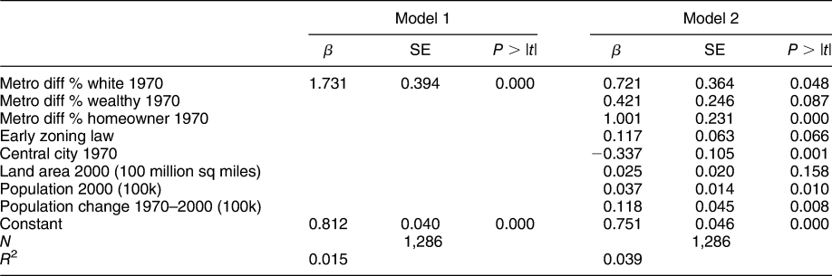
In a second specification, I add controls for the city/metro area difference in the share of the city that is Wealthy (above the 90th percentile in income), and the share of households that are Homeowners in 1970.Footnote 11 These variables are intended to account for the other dominant pressures for land use regulation, minimizing redistribution and maximizing housing value, that are also highly correlated with racial makeup of the community. To ensure that the 1970 demographic data are not the result of earlier land use regulations, which then predict future land use stringency, I add a dummy variable denoting whether a city had a zoning law in place before 1930 (after which federal guidelines made zoning ubiquitous).Footnote 12 I also add an indicator, Central City, designating whether the city was the largest city in the metro area by population in 1970. To account for the possibility that land use control responds to congestion associated with changing population size and the need to manage space, I include the total City Population in 2000, the total Land Area in 2000, and the Change in City Population between 1970 and 2000. I cluster the errors by metro area. The dependent variable is left censored at zero, so I estimate Tobit models with robust standard errors. Table 1 presents the results.
Correlates of Restrictive Land Use

Note: Tobit regression; robust standard errors clustered by 197 metropolitan area.
The table reveals that cities that were whiter than the metropolitan area in 1970 had significantly more restrictive land use regimes in 2006. The powerful negative coefficient on central city and positive coefficient on land area suggests that land use stringency is not predominantly about managing space. However, cities that witness more rapid population changes do appear to have more stringent land use regimes. In addition to whiteness, homeownership and wealth also positively predict land use restriction. Because homeownership and wealth in 1970 are highly correlated with whiteness, variation in these variables accounts for about half of the direct effect of whiteness on land use restrictiveness.
What does this look like in practice? We can compare three cities in the Los Angeles–Long Beach metropolitan area, one with a 1970 white population share 6 percentage points lower than the metropolitan average (Carson City), one slighter whiter than average (Pomona), and one with a 1970 white population that was 13 percentage points higher than average (Glendora). As of 2006, Glendora involves more actors and has more official veto points in the development process than Pomona, and Pomona features more than Carson City. Glendora required local zoning board approval for rezoning, whereas Pomona and Carson City did not. Only Glendora had both one- and two-acre minimum lots sizes for neighborhoods. The average time to review residential development in Glendora is 2 years, compared with about 6 months for both Pomona and Carson City. Survey respondents were asked how important citizen opposition to growth is in limiting development on a 1–5 scale. Glendora received a score of 5 compared with Pomona’s score of 3 and Carson City’s score of 1. Overall, Glendora has the most rigid land use regime of the three cities, and this is just what Glendora voters want.
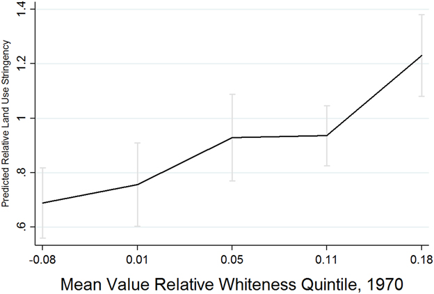
The estimation in Table 1 presumes that there is a linear relationship between community whiteness and land use restriction. But, if communities are using land use regulations to protect exclusivity and minimize negative peer effects, we might expect a more powerful result at the top end of the distribution. To see whether this is the case, I divided the 1970 relative white population share into quintiles. The first quintile contains cities that are less white than the metro area as a whole. The second quintile ranges from parity with the metro area to about 3% whiter. The third quintile ranges from 3% to 8% whiter, the fourth from 8% to 15% and the top quintile includes cities that are 15% to 33% whiter than the metropolitan area. I use the same model as Table 1, Column 1 and regress the Relative WRLURI on these quintiles (with the first quintile as the comparison category). Figure 1 plots the linear prediction of land use stringency for each quintile.
Linearity of Relationship Between 1970 Whiteness and 2006 Land Use Stringency

Even cities that were modestly whiter (>3%) than the larger metropolitan area have more stringent land use policies than cities that were less white than the metro area. But, the figure reveals that the most powerful effect is at the top end of the scale. When cities are greater than 15 percentage points whiter than the metro area, they are more likely to restrict land use than all other quintiles. It appears that this group of cities best represents the theoretical concept of communities seeking to manage which types of people have access to their public goods (e.g., racial peer effects). This pattern is evident in the Los Angeles area cities described above—Carson City’s relative land use stringency is 0.71, Pomona’s is 1.18, and Glendora’s is 3.87.
THE EFFECT OF LAND USE RESTRICTION
If land use regulation is a tool to solve collective action problems inherent in the production of public goods, we would expect communities with more stringent regulations to be more likely to maintain demographic exclusivity over time. Is this what we see? The answer is yes. Generally, cities with more restrictive land use regimes remained whiter between 1970 and 2011 than cities with less restrictive policies.
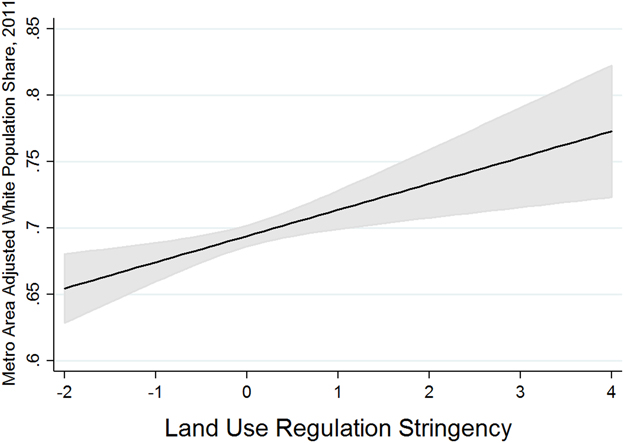
I begin with a descriptive analysis using the WRLURI as an independent variable, predicting Percent White in 2011, controlling for Percent White in 1970, Percent Homeowners in 1970, and Percent Wealthy in 1970. If my argument is correct, the WRULRI should positively predict Percent White in 2011, after we account for the fact that whiter communities today are likely to have had a higher share of homeowners and would have been whiter and wealthier in 1970 than other cities in the metropolitan area. The model includes fixed effects for metro area to determine the effect of restrictive land use on demographics relative to changes in neighboring communities. Figure 2 presents the results of this analysis. It shows that cities with more stringent land use laws were whiter than their metro area neighbors in 2011, even controlling for their demographic makeup in 1970.
Association Between Land Use Restriction and City Demographics

The United States has diversified significantly since the 1970s. In my dataset, the average city was 94% white in 1970 and only 69% white in 2011. Figure 2 reveals that land use restriction is significantly associated with the growth of the white population relative to other cities in the metropolitan area. What this means is that cities with more restrictive land use regimes tended to diversify more slowly than their neighbors. But, how can we be sure that these cities would not have witnessed a slower pace of diversification regardless of their land use practices? To provide additional evidence that land use regulation plays a role in shaping demographics, I draw on data from federal court cases.
As explained above, in 1968, Congress enacted the Fair Housing Act. Soon after, both the Justice Department and private parties began to bring charges against local governments that were perceived to have violated the law. Technically Title VIII of the Civil Rights Act of 1968, the Fair Housing Act prohibits discrimination in the sale, rental, or financing of housing based on race, color, national origin, religion, sex, familial status, and disability. Importantly, the Act also makes it unlawful for municipalities to make housing unavailable to persons from the protected classes. For instance, if a city’s land use regulations (or application of the regulations) prevent the building of multi-family housing, and this is shown to disproportionately affect people of color, the city can be sued for violation of the Act. Plaintiffs can establish a violation by showing that the city failed to make reasonable accommodations in rules, policies, or practices that would afford people from protected classes an equal opportunity to live in a dwelling. Once a violation is established, the Act entitles plaintiffs to injunctive relief—meaning that the city is ordered by the court to change its land use policy.Footnote 13
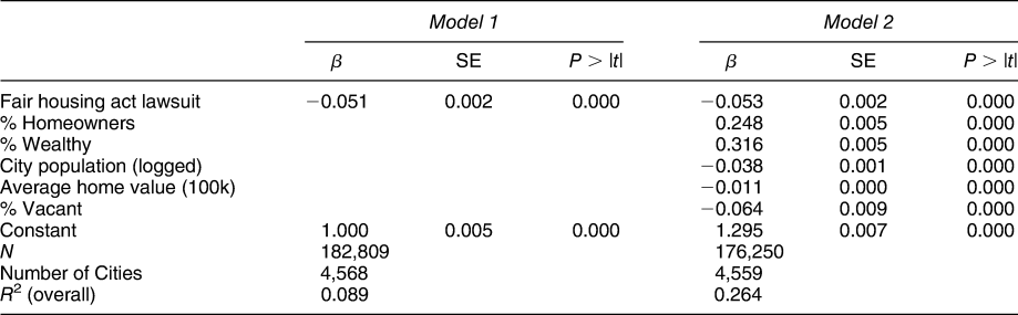
To locate cases that meet these conditions, I searched Lexis Uni for all Federal and State cases containing the terms “Fair Housing Act” and “injunct*” between 1968 and 2010.Footnote 14 I recorded the date of each decision, and for a subset of the cases, I read the case and recorded the outcome.Footnote 15 This resulted in a time series dataset of Fair Housing Act cases involving municipal governments. I then combined these Fair Housing Act data with demographic data from the Census of Population and Housing for all incorporated cities in metropolitan areas from 1968 to 2011. I have a total of 4,568 cities and 182,809 observations. Of these, 199 cities were engaged in a Fair Housing Act lawsuit during the timespan. If my argument is correct, cities that were sued under the Fair Housing Act should be enjoined to have less restrictive land use policies than they otherwise would have had. So, I expect their white population share to be lower than it would have been without the lawsuit. Obviously, the cities that face lawsuits differ in important ways from cities that do not face lawsuits. So, my analysis includes fixed effects for cities, enabling me to compare the white population share before and after the court’s intervention in the same place. Additionally, during this time period, the United States was becoming less white overall. I include year fixed effects to account for the trend and all other time-varying confounders.
I estimate the following equation:
 $$w_{jt} = \alpha _j + \beta _t + cF_{jt} + \varepsilon _{jt} ,$$
where j indexes city and t indexes time. F is a binary indicator for the court having decided city j’s first Fair Housing Act Lawsuit as of time t and w is the city’s White Population Share in city j at time t.Footnote 16 Identification of c requires that the timing of the court’s decision in the Fair Housing Act lawsuit be uncorrelated with other time-varying factors that affect the white population share of the city, conditional on city and year fixed effects. So, in a second analysis, I include controls for the city’s Percent Wealthy, Percent Homeowners, and the natural log of total City Population, all of which could affect the racial makeup of the city’s population and play a role in the likelihood that a lawsuit is filed in a particular year. To account for differences in demand across housing markets, I control for the city’s Average Home Value, and the share of housing units that are Vacant. Footnote 17 Table 2 presents the results.
Effect of Land Use Change on City Whiteness, 1968–2011

Note: OLS regression; DV is share of the city population that is white in each year. Fixed effects for cities and years included but not presented.
Table 2 offers clear evidence that when cities are threatened or forced by the court to liberalize their land use laws they see growth in their population of people of color. In 1970, the average city was about 94% white, whether it would later face a Fair Housing Act lawsuit or not. By 2011, cities without lawsuits were about 73% white on average, compared with 68% white in cities with lawsuits.Footnote 18 Land use regulations have the power to shape the demographics of communities. In the final section, I provide evidence that voters in white communities are supportive of these restrictions.
PREFERENCES FOR LAND USE REGULATION
To analyze preferences over local land use policies, I draw on precinct level election returns on local initiatives from several California cities. I expect that people who live in whiter neighborhoods will be more supportive of stringent land use policy. First, I gathered information on all local initiatives dealing with land use that were on the ballot in the general election in 2016. Then, I limited the set to initiatives clearly affecting residential development. This produced a list of 14 initiatives from six counties (described in Online Appendix Table A.1). Some initiatives propose to build new housing. For example, in Pacifica, voters were asked to authorize “up to 206 multi-family units.” In other cases, the measure made residential development more difficult or prohibited it directly. Morgan Hill voters had the opportunity to voice their preference for establishing “a population ceiling of 58,200, with a slower rate of growth than currently exists, and [to] improve policies to maintain neighborhood character, encourage more efficient land use, conserve water, and preserve open space.” In the 2016 election, California voters overwhelming supported development restriction. Pro-growth initiatives garnered an average of 42% of the vote, whereas anti-growth initiatives garnered better than 60%. However, support for development restriction was not uniform.
To determine which neighborhoods were most likely to favor restrictive land use, I gathered precinct level election returns on every measure from each county registrar of voters, and data on the partisan and racial makeup of the voters for each precinct from the California Statewide Database (California’s data repository for redistricting).Footnote 19 Then, I consolidated precincts to the Census tract level using geographic information system (GIS) mapping, and merged data on homeownership and wealth from the 2011 American Community Survey. After dropping tracts with fewer than 10 voters (and thus offering unreliable demographic proportions), I have data on 456 tracts across the 14 initiatives.
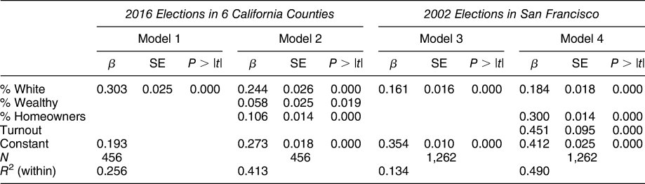
My dependent variable in this analysis is Percent Restrict: the share of ballots cast in the initiative election that supported restricting development. The main independent variable is the share of voters that are White. I control for the share of households that are Homeowners, and the share of the population that is Wealthy.Footnote 20 To ensure that these results were not an artifact of the consolidation to the Census tract level, I gathered additional precinct data from two residential development initiatives that were presented to voters in 2002 in San Francisco where I was able to get data on both ownership and racial demographics (but not wealth) at the block level.Footnote 21 A description of the initiatives, their ballot placement source, votes needed to pass, and total vote received is included in table Online Appendix A.2.Footnote 22 I used GIS to match vote precinctsFootnote 23 and Census block boundariesFootnote 24, generating total populations of Homeowners and non-Hispanic Whites in each voting precinct.Footnote 25 Because these data are for residents, not voters, in the San Francisco analyses, I also control for Total Turnout. This resulted in complete data for 631 precincts.
Scholars debate the best way to generate inferences from these kinds of data (Box-Steffensmeier, Brady, and Collier Reference Box-Steffensmeier, Brady and Collier2010; Gelman et al. Reference Gelman, Park, Stephen, Price and Minnite2001; King Reference King1997; King, Rosen, and Tanner Reference King, Rosen and Tanner2004). Because I am interested in estimating the behavior of neighborhoods not individuals, I use a straightforward ecological regression, with fixed effects for each measure, to determine the relationship between the demographic composition of neighborhoods and support for restricting development. Table 3 presents the results.
Correlates of Support for Restricting Residential Development

Note: Fixed effects for measure included but not presented.
The analyses from both sets of data reveal that whiter neighborhoods are supporters of residential restriction, even after controlling for wealth and homeowner status (which are, of course, both related to the race of residents). For example, Model 4 predicts that in San Francisco about 28% of voters supported restricting development in precincts that were comprised of 10% white residents, compared with 68% support in precincts that were 90% white. The data also reveal that tracts with more homeowners and wealthy residents also support restriction at higher rates.
To determine what voters might have understood about the implications of voting in favor of or against each initiative, I analyzed ballot statements and news reports covering the measures. Online Appendix Table A.3 presents a summary of statements that were printed in the 2016 California voter guide in support or opposition to the initiatives. I find that concerns about affordability, density, traffic, open space, and community character featured prominently in the debates over these land use initiatives. Coverage in local newspapers also made the trade-offs clear. Writing about Santa Monica’s Measure LV, the Los Angeles Times reported that “critics of the ballot measure worried that it would grind development to a halt, hurting the local economy. They argued that some new housing is necessary and could reduce prices.”Footnote 26 On the other side were supporters who “said Measure LV would protect the beachside city’s character by stopping high-rise development….[and] prevent traffic on increasingly congested roads from getting worse.”Footnote 27 In Encinitas, the Affordable Housing Coalition of San Diego County threatened to sue the city over its persistent refusal to “accommodate its future housing needs, particularly those of low-income people,” whereas opponents argued that the “proposed zoning changes would allow the construction of extra-dense, extra tall buildings that would destroy the city’s small town character.”Footnote 28 On Pacifica’s Measure W, the Peninsula Press explained, “The heart of the debate is whether adding more homes to Pacifica’s coastline is good for the city. Measure W comes at a time when communities throughout the Bay Area are struggling to keep up with surging populations that have resulted in housing shortages and heated debates over building more homes versus preserving open space.”
In short, new development was purported to lower housing costs and increase access to the housing market, while increasing density, traffic, and decreasing open space. However, as the tract level analysis in Table 3 showed, support for land use restriction was not uniform across neighborhoods. As my theory would suggest, neighborhoods with larger shares of homeowners, wealthy, and white residents supported restriction. We cannot know if voters in these neighborhoods were motivated by worries about housing values, congestion, redistribution, peer effects, or some combination of factors. But, together with the evidence presented in previous sections, what we do know is that restrictive land use regulation contributes to racial segregation across city lines. The analyses in Table 3 suggest that is wealthy white homeowners who are most likely to favor these policies.
CONCLUSION
Many metropolitan areas in the United States are facing a crisis of housing affordability. Homelessness is on the rise as rents and housing prices skyrocket. The problem is largely the result of limited growth and development. This modern reality offers a stark contrast to the America of the 1950s and 1960s when a housing boom, federal mortgage programs, and new highways brought hundreds of thousands of people to rapidly developing suburban communities. Suburbs pulled people from the rural hinterlands, from central cities, and from foreign nations. But, during this period, the residents who had access to suburbs were nearly exclusively white. I have shown that places that were whiter in 1970 have locked in that demographic profile using land use restriction and I showed that cities with more stringent land use remain whiter over time. I provided evidence that white voters are more likely to support restricting development in initiative elections and that more stringent land use regimes generate whiter cities. It is this maintenance of homogeneity that generates segregation across city lines. Given Americans’ overwhelming commitment to local control—it is likely to be a pattern that persists.
SUPPLEMENTARY MATERIAL
To view supplementary material for this article, please visit https://doi.org/10.1017/S0003055419000844.
Replication materials can be found on Dataverse at: https://doi.org/10.7910/DVN/5MAQC2.




Comments
No Comments have been published for this article.