The Middle to Late Ordovician is one of the key time intervals in the evolution of life on Earth when biodiversity rapidly increased, and it is named the Great Ordovician Biodiversification Event (Webby Reference Webby, Webby, Droser and Percival2004). This event is not ascribed to the preservational effect of the evolution of shell-secreting animals, but is supported by an increase in the ichnofaunal diversity (Droser & Bottjer Reference Droser and Bottjer1989; Mángano & Droser Reference Mángano, Droser, Webby, Paris, Droser and Percival2004). The data were, however, limited to the bottom of epeiric seas and ‘deep seas’, where coarse clastic materials had been deposited, and the results are biased due to the lack of data from true pelagic deep seas that are recorded in accreted sedimentary rocks in Paleozoic fold belts (Webby Reference Webby, Webby, Droser and Percival2004).
Radiolarian chert was initially deposited on a deep-sea bottom below the carbonate compensation depth, far away from continents, so that coarse terrigenous particles are absent for over tens of millions of years. During the destruction of the huge ocean, the radiolarian chert, along with a thick turbidite succession, was conveyed and accreted to a continental margin, and is now exposed on land. With this origin, radiolarian chert is a unique sedimentary rock that records changes in the environment of the pelagic ocean realm.
Radiolarian chert of the Lachlan Fold Belt in the southeastern margin of Australia indicates that benthic animals on the pelagic ocean bottom of Panthalassa, sparse in the Middle to Late Cambrian, increased their activity and morphological variety by the late Middle Ordovician (Kakuwa & Webb Reference Kakuwa, Webb, Bromley, Buatois, Màngano, Genise and Melchor2007, Reference Kakuwa and Webb2010; Percival Reference Percival2012). This is the first evidence for the Great Ordovician Biodiversification Event in the pelagic deep ocean. However, no detailed record has been described from the other large contemporaneous ocean, Iapetus and, in the absence of such a study, the event might be limited to a local event of the Panthalassan Ocean. Our aim here is to rectify this omission, and to provide supporting evidence from middle to upper Ordovician radiolarian chert and its associated rocks from the Iapetan Ocean in the Southern Uplands of Scotland.
1. Geological setting of studied outcrops
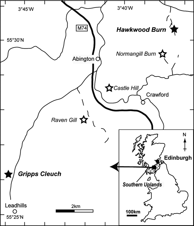
Ordovician and Silurian deposits are distributed in a narrow zone extending southwest to northeast in the Southern Uplands of Scotland (Fig. 1). In this zone, thrust faults have repeatedly emplaced internally-coherent successions of turbiditic sandstone overlying graptolitic black shale which, in turn, rests on minor amounts of chert and basic volcanic rocks. Within each imbricated packet, the strata are steeply dipping (commonly even overturned) and typically young towards the north. However, taken overall, each successive fault-bounded turbidite packet youngs towards the south – the long recognised ‘Southern Uplands paradox’ (McKerrow et al. Reference McKerrow, Leggett and Eales1977). A fore-arc accretionary prism is proposed as the origin of this rock association and occurrence (Mitchell & McKerrow Reference Mitchell and McKerrow1975; McKerrow et al. Reference McKerrow, Leggett and Eales1977; Leggett et al. Reference Leggett, McKerrow and Eales1979, Reference Leggett, McKerrow, Casey and Leggett1982; Leggett Reference Leggett1987; McKerrow Reference McKerrow1987; Ogawa Reference Ogawa1998). A back-arc basin model (Murphy et al. Reference Murphy and Hutton1986; Hutton & Murphy Reference Hutton and Murphy1987; Morris Reference Morris1987; Stone et al. Reference Stone, Floyd, Barnes and Lintern1987) and a continental-margin extension-basin model (Armstrong et al. Reference Armstrong, Owen, Scrutton, Clarkson and Taylor1996, Reference Armstrong, Owen and Floyd1999: Owen et al. Reference Owen, Armstrong and Floyd1999) have also been proposed. The latest papers of Waldron et al. (Reference Waldron, Floyd, Simonetti and Heaman2008, Reference Waldron, Schofield, Dufrane, Floyd, Crowley, Simonetti, Dokken and Pothier2014) suggest, based on analyses of pervasive detrital zircon, that the sedimentary rocks of the Southern Uplands were deposited on an oceanic crust and were subducted and accreted to the Laurentian margin.
Locality map. Black square on inset map shows area of detailed map. Filled stars mark the localities mentioned in the present paper. Open stars mark the localities where no trace fossils have been found and are, therefore, not mentioned in the present paper.

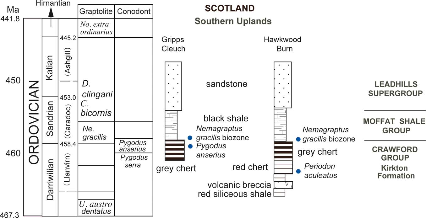
The oldest rock of the Southern Uplands belongs to the Crawford Group, which is composed of basic volcanic rocks, mudstone and radiolarian chert (Fig. 2). The group is divided into the Raven Gill and Kirkton formations, which are distributed in the Northern Belt of the Leadhills Imbricate Zone. The Raven Gill Formation consists of basic volcanic rocks with pillow structures, brown mudstone and radiolarian chert. Conodonts of middle Arenig age are reported from the Raven Gill brown and red mudstone with radiolarian chert (Oepikodus evae Biozone; Lamont & Lindström Reference Lamont and Lindstrom1957; Armstrong et al. Reference Armstrong, Clarkson and Owen1990). Brown mudstone from Raven Gill yields the acrotretid brachiopod Paterula (Lamont & Lindström Reference Lamont and Lindstrom1957). Radiolarians and sponge spicules have been found in the Raven Gill red chert, but no age constraint is given (Danelian & Floyd Reference Danelian and Floyd2001).
Stratigraphical chart showing the ranges of the studied geological formations of the Southern Uplands, Scotland.

The Kirkton Formation overlying the Raven Gill Formation consists of basic lava more than 50 m thick, and siliceous mudstone and chert that are 70 m thick at the type section (Floyd Reference Floyd1996). Pygodus anserius, indicating a late Llanvirn to early Cardoc age, has been recovered from red chert at the Glencaple Burn, Kilbucho and Crawford sites (Armstrong et al. Reference Armstrong, Clarkson and Owen1990, Reference Armstrong, Owen, Scrutton, Clarkson and Taylor1996, Reference Armstrong, Floyd, Tingqing and Barron2002; Clarkson et al. Reference Clarkson, Harper, Owen, Taylor, McAdam, Clarkson and Stone1993; Danelian & Clarkson Reference Danelian and Clarkson1998; Danelian & Floyd Reference Danelian and Floyd2001). The same conodont is reported from the grey chert of Gripps Cleuch (Floyd Reference Floyd2001), implying that at least some of the red and grey cherts are contemporaneous (Fig. 2).
The Moffat Shale Group that overlies the Crawford Group consists mainly of black and grey shale. Grey chert of the Kirkton Formation, bearing conodonts of the P. anserius Biozone, grades upward into the black shale of the Moffat Group, which includes graptolite of the gracilis–wilsoni Biozone (Floyd Reference Floyd2001). Meta-bentonite beds originating from volcanic ash frequently occur during the early Ashgill to the middle Llandovery. The Leadhills Supergroup, mainly consisting of turbidite sandstone, overlies the Moffat Shale Group.
Evidence of trace fossils has been sought in five localities where radiolarian chert and siliceous mudstone are exposed: Gripps Cleuch; Hawkwood Burn; Raven Gill; Norman Gill; and Castle Hill Well (Fig. 1). Because trace fossils have been found only at Gripps Cleuch and Hawkwood Burn, the latter three localities are not discussed further.
2. Description of the measured sections
2.1. Hawkwood Burn
2.1.1. West stream bank
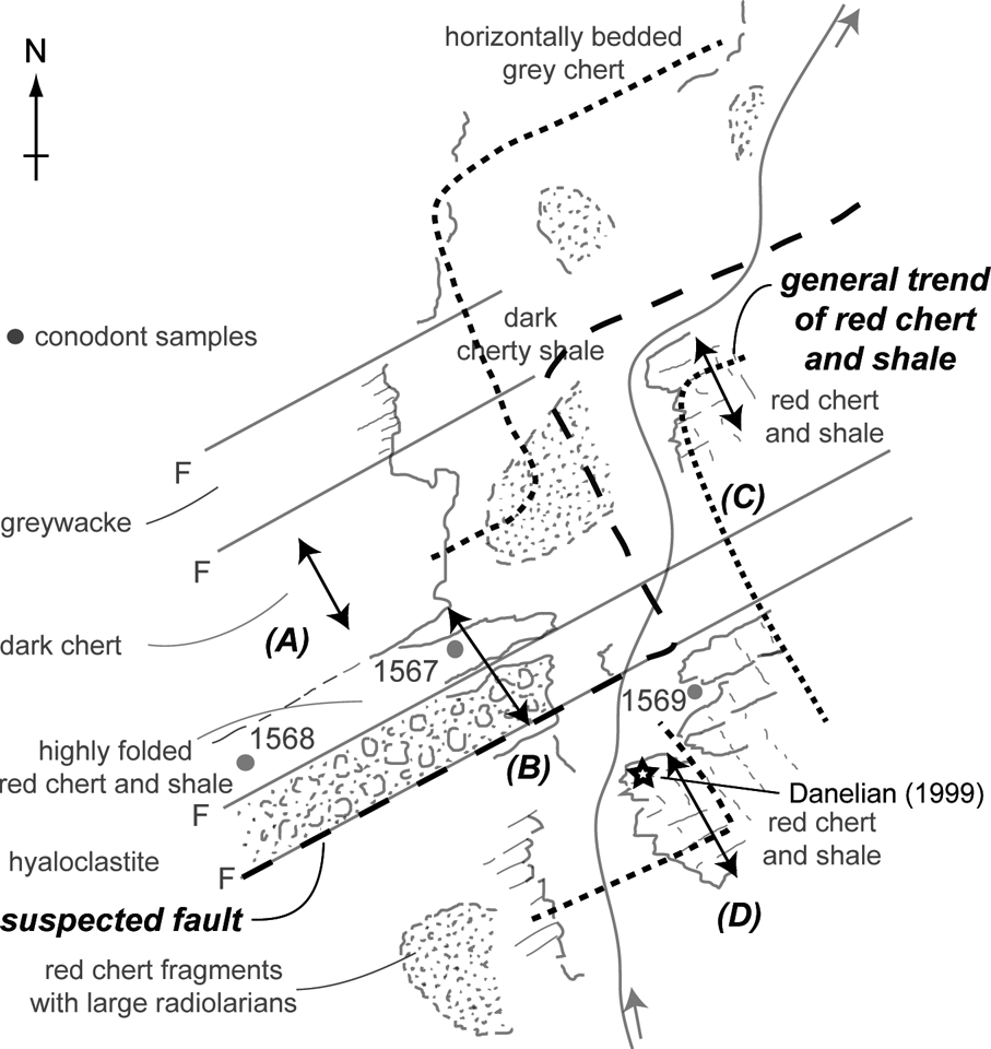
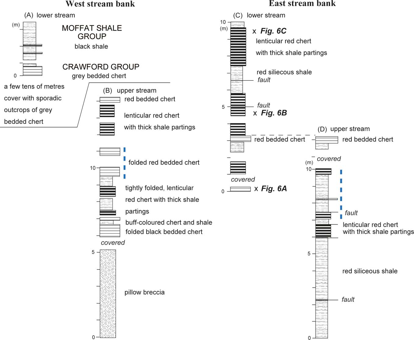
Isolated outcrops are distributed on both sides of the valley, whose stream flows south to north (Fig. 3). The measured section of the west bank contains both volcanic breccia (hyaloclastite in Fig. 3) and chert, from the upper stream to the lower stream (Fig. 3). The 7–8 m-thick breccia consists of boulders of basaltic pillow lava and rare gabbroic rock in a matrix of sand-sized hyaloclastite, with sedimentation thought to have been virtually instantaneous. Black chert, 1 m in thickness, buff-coloured shale with chert beds, and red chert occur stratigraphically above the volcanic breccia (Fig. 4, column B). The cherts are intensively folded and faulted. Red chert with thick siliceous red-shale beds is found as isolated outcrops in the lower reaches of the stream. The chert in these outcrops is also intensively folded, so that the same horizon should occur repeatedly. This lithology is quite similar to the rocks on the right bank.
Sketch map of the Hawkwood Burn modified from Armstrong et al. (Reference Armstrong, Owen and Floyd1999). The four measured sections are indicated as A–D.

Lithological columns of measured sections in Hawkwood Burn. Blue dashed lines indicate suggested fossil horizons. Columns (C) and (D) are correlated by both the general trend and the lithology of the rocks in the field. The correlation between the west and east banks is based on lithology, and is more problematic.

Small outcrops of blue-grey chert sporadically occur in widespread scree on the slope of the west stream bank further downstream (Fig. 3). The measured thickness of the grey chert is more than 5 m, but the total thickness is unknown because of poor exposure. Chert layers of 4–6 cm thickness occur in the bottom of the black shale of the Moffat Shale Group (Fig. 4, column A). This occurrence is quite similar to the contact between the Kirkton Formation and the succeeding Moffat Shale Group described at the type locality of Gripps Cleuch by Floyd (Reference Floyd1996). Fine-grained sandstone and buff-coloured mudstone occur further downstream.
2.1.2. East stream bank
The measured outcrops are largely separated into two, along the upper and lower streams, by an apron of talus deposits and vegetation for up to 20 m along the creek (Fig. 3). The outcrop along the upper stream consists of vertically-dipping red siliceous shale and red chert. The general trend of the rocks is nearly parallel to the valley, and the same association occurs repeatedly in tight folds across some isolated outcrops. The apparent lower horizon consists of red siliceous shale and the upper horizon consists of lenticular red chert beds with thick red shale partings (Fig. 4, column D). The total thickness of the red chert and siliceous shale association is estimated to be 12 m.
A similar rock association occurs in the lower stream with a comparable structure. Deformed and lenticular chert beds with thick shale partings are much more abundant than along the upper stream (Fig. 4, column C) and the total thickness is here estimated at 10 m. The upper part of the outcrop along the upper stream is correlated with the lower part of the lower stream by the general trend and lithology of the strata.
The conodonts Periodon aculeatus, Prioniodus, Drepanoistodus and Protopanderodus were found in the red chert of the Hawkwood Burn, indicating a Llanvirn age (Armstrong et al. Reference Armstrong, Clarkson and Owen1990). Fossil localities are shown in Figure 3 and the estimated horizons of the conodonts in the lithologic columns are shown in Figure 4. Radiolarians that indicate upper Llanvirn to Caradoc ages were also reported from the red chert of a similar horizon (Danelian Reference Danelian1999).
2.2. Gripps Cleuch
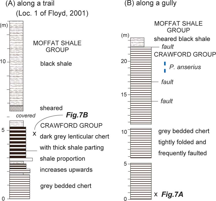
The measured outcrop occurs in two sections, one situated along a trail on the hillside (locality 1 of Floyd (Reference Floyd2001), the type section for the base of the Moffat Shale Group), and the other in isolated small cliffs along the right bank of the small gully. The grey chert of the Kirkton Formation at locality 1 gradually changes to the black shale of the Moffat Shale Group, with a slight disturbed zone (Fig. 5).
Lithological columns of the measured sections in Gripps Cleuch. The blue dashed line indicates a suggested conodont horizon.

The pure grey, bedded chert layers average 44 mm in thickness, gradually changing to argillaceous chert further up the section. The argillaceous chert is thinner in the upper horizon (chert layers are 36 mm thick on average), with thicker shale partings than in the lower horizons of locality 1. It changes from planar to lenticular form and, finally, to black shale. Load cast structures in chert layers of the lower horizon are concordant with the general succession. The chert section was measured as 5 m thick and the black shale section as 11.5 m thick. The measured part of the Moffat Shale Group consists entirely of black shale, without any sand-sized clastic grains.
The outcrops along the gully are separated by faults and talus deposits. Stratigraphically higher horizons are exposed in the upper stream in general, but intensive folding in the chert hampers any determination of the exact relationship between the outcrops. Sheared black shale and folded grey chert are exposed in the uppermost part, but the contact between the chert and black shale is faulted. Tightly folded grey chert, 22 m thick, is exposed in several outcrops bounded by faults, although there is probably some duplication by imbrication. The average thickness of individual chert beds is 30–35 mm in the lower horizon, increasing to 40 mm in the upper horizon. Shale partings are generally 1–3 mm thick, although some partings up to 10 mm occur in the upper horizon.
P. anserius in the uppermost horizon of the chert indicates that chert deposition lasted until the late Llanvirn to early Caradoc; and the gracilis–wilsoni Biozone in the lowest part of the black shale indicates that black shale deposition began in the early to middle Caradoc (Floyd Reference Floyd2001).
3. Occurrence of trace fossils and biodeformational structures
3.1. Hawkwood Burn
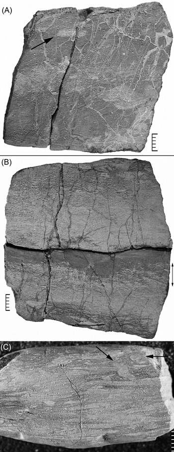
Cut and polished surfaces of the red cherts are massive and show no signs of bioturbation or sedimentary laminations in most cases, but uneven distributions of radiolarian skeletons are observed on hydrofluoric acid-etched (HF-etched) surfaces of the cherts. For example, radiolarians are concentrated in a lenticular form that can be understood as a compacted cross-section of a burrow tunnel, such as that of Planolites (Fig. 6A). The uneven distribution of radiolarians in the radiolarian-rich zone in the middle part of the chert is interpreted as a biodeformational structure. Irregular contacts between the shale partings and the chert layers (Fig. 6B) can be ascribed to the activities of benthic animals, which churned up mud and radiolarians during the slow pelagic deposition of clayey materials after the relatively rapid deposition of radiolarians. However, neither example shows the diagnostic shapes of the trace fossils, so it is possible that they were formed by either a reworking of radiolarians or a diagenetic deformation.
Hydrofluoric acid-etched surface of red chert cut perpendicular to bedding plane. Hawkwood Burn: (A) white spherules are radiolarian skeletons. Arrow indicates suspected cross-section of a burrow cut obliquely to its length. Other suspected bio-deformational structures are found in the middle part of the specimen; (B) double-ended arrow indicates the mixing interval between the upper red shale parting and the lower grey chert composed of radiolarians; (C) white laminations consist of poorly preserved radiolarians, fragments of radiolarians and microcrystalline quartz. Arrows indicate probable burrows that cross-cut the laminations. Scale bars=5 mm.

White laminations consisting of fragmented radiolarians and microcrystalline quartz cement develop on the HF-etched surface of a red argillaceous chert (Fig. 6C). These parallel laminations are cut by an irregularly shaped structure consisting of materials similar to the laminations. This texture can be interpreted as a burrow, but with activity of benthic animals still so low as to preserve sedimentary laminations. Radiolarians of some other red chert beds in these outcrops are cemented well, and the beds are tectonically brecciated and/or cut by numerous veins. These instances do not allow the identification of trace fossils. Red shales exhibit massive character and show no sedimentary lamination or biodeformational structures in Hawkwood Burn, Raven Gill or Castle Hill.
3.2. Gripps Cleuch
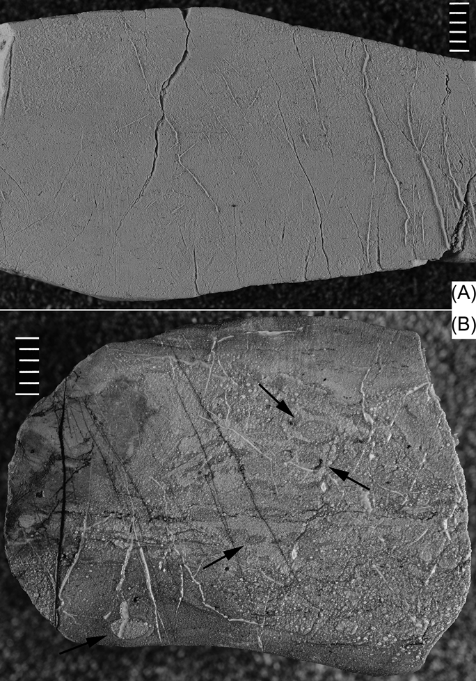
Most dark- to pale-grey cherts of the Kirkton Formation in Glipps Cleuch are tectonised, and radiolarians are poorly preserved in general. No diagnostic textures of trace fossils or sedimentary laminations are observed on cut and polished surfaces of the cherts. HF-etched surfaces reveal that most of this chert is massive and no biodeformational structures can be observed (Fig. 7A). This is the most typical chert that is examined, not only in Gripps Cleuch but also in Raven Gill, Castle Hill and Normangill Burn.
Hydrofluoric acid-etched surface of grey chert bed cut perpendicular to bedding plane. Gripps Cleuch: (A) white spherules are poorly preserved, but strongly cemented, radiolarian skeletons. Quartz veins run oblique to the bedding plane, especially in the right half of the sample. No diagnostic trace fossil features are observed; (B) white spherules are moderately well preserved radiolarian skeletons. Elliptical shapes indicated by arrows are interpreted as compacted Planolites burrows. Scale bars=5 mm.

One argillaceous chert from the uppermost part of the Kirkton Formation shows an irregular distribution of radiolarian skeletons, amongst which radiolarian-rich lenses occur in a radiolarian-poor background, and vice-versa (Fig. 7B). These lenses, which are smaller than 2×4 mm, may be compacted cross-sections of Planolites-like burrow tunnels. Other irregular distributions of radiolarians may also reflect biodeformational processes.
Various trace fossils are found on polished surfaces of one siliceous mudstone (claystone) bed in the Moffat Shale which is situated around 12 m above the contact between the Crawford Group and the Moffat Shale Group. The outcrop is otherwise covered by talus deposit. A 4 cm-thick grey siliceous mudstone interbed occurs in a black laminated mudstone. The siliceous mudstone is light greenish-grey in colour and partly weathered to purplish red. Trace fossils are recognised by their distinctive shapes which are filled with dark-coloured materials, probably of organic matter from the grey matrix. Nodular and cubic pyrites are common in the rock. Trace fossils are divided into several shape types.
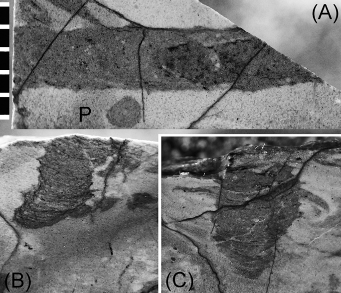
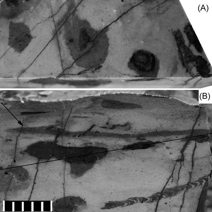
Type A, which appears on a surface cut vertical to the bedding plane, is 5 mm in length and 2.5 mm in width. It has a tongue-like shape with a ragged margin, and shows meniscus-shaped packing laminations in the burrow fill (Fig. 8B, C). It is a simple tube without wall and internal textures on the bedding plane (Fig. 8A). A similar simple tube with a diameter of 4 mm is found on the other bedding plane. Its cross-section also shows a lenticular shape on one side and a laminated column with a weakly ragged margin on the other. Both burrows are tentatively identified as Teichichnus isp. The meniscate internal structures are interpreted as packing structures produced by the animal as it moved forward.
Polished surface of grey siliceous claystone bed, Gripps Cleuch, showing a tongue-like shape with a ragged margin and laminations in the burrow fill: (A) it is a simple tube without walls and internal textures on the bedding plane. The dark circle (P) is a cross-section of a simple burrow (Planolites) that runs perpendicular to the bedding plane. (B–C) a vertical cross-section of a burrow system. Scale bar=5 mm.

Type B has a circular shape, with a multi-ringed internal texture on the polished surface parallel to the bedding plane (Fig. 9A) and a lenticular shape in cross-section (Fig. 9B). The lenticular shape displayed on the surface vertical to the bedding plane is a result of compaction.
(A) Polished surface cut slightly oblique to bedding plane in a siliceous claystone. (B) Location of the polished plane, cut perpendicular to bedding plane. The simple burrow that runs horizontally in the upper part is probably Planolites. The burrow filled with alternating black and white meniscus bands on the lower right is interpreted as Compaginatichnus (?). Scale bar=5 mm.

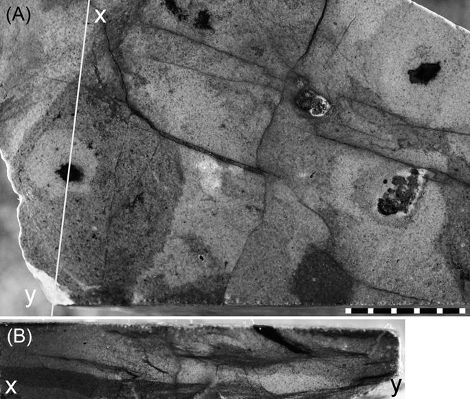
Type C is a single circular burrow tunnel, which is filled with pale grey sediments and has a tiny pyritised tube, whose diameter is around 1mm in its central section (Fig. 10). It is not clear whether the darker circle that envelops the pale grey circle is an essential component of this burrow.
(A) Polished surface of grey siliceous claystone cut parallel to bedding plane; (x–y) is the cut line. (B) Polished surface of grey siliceous claystone cut perpendicular to bedding plane (x–y). Scale bar=5 mm.

Type D is a simple burrow and is the most common type of shape in the examined specimen. It has no internal texture or wall parallel to the bedding plane (P in Fig. 8) and the polished surfaces are perpendicular to the bedding plane (arrowed in Fig. 9). The burrow tunnel is filled with dark grey to black sediments that are darker than the host sediments. Its size is 1.5– 2 mm in diameter and 4 –5 mm in length. Planolites isp.
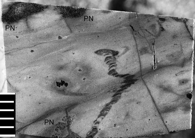
Type E, characterised by a chain consisting of alternating black and white menisci, is also a common trace fossil found on polished surfaces. It may run parallel to, vertical to (Fig. 11) or oblique to the bedding plane (Fig. 9). The width of the menisci is 1 mm. The systematic spreite, the marginal tube and the central shaft that characterise Zoophycus isp are not recognised. Thus, this unbranched string of active-filling menisci is correlated to Compaginatichnus (Pickerill, Reference Pickerill1989).
Polished surface of grey siliceous claystone cut perpendicular to bedding plane, Gripps Cleuch. A burrow tunnel with an active-filling meniscus texture runs almost vertical to the bedding plane. The aggregates of dark spherules at the upper and lower left (PN) are small pyrite nodules. Scale bar=5 mm.

4. Discussion
4.1. Succession at Hawkwood Burn
Armstrong et al. (Reference Armstrong, Clarkson and Owen1990) correlated the red chert with pillow breccia on the west bank to the covered horizon between the two outcrops of the chert on the east bank. They thus considered the lithologic succession at the outcrop of Hawkwood Burn to comprise red chert on the east bank of the upper stream, red chert with pillow breccia on the west bank, red chert on the east bank of the lower stream, and grey chert on the west bank from the lower to the upper in exposures along the entire valley section (Fig. 3).
The general bedding trend of chert and the observed lithologic resemblances, however, suggest that the distribution of red chert and red shale on the east bank takes an S-like shape and that the scree of red chert on the west bank is correlated to the red chert on the east bank. The uppermost horizon of the red chert on the upper stream of the east bank (column D in Fig. 4) repeatedly occurs on the lowest horizon of the lower stream's west bank (column C in Fig. 4). This leaves the question of the proper stratigraphic location of the breccia. We interpret that the red chert and shale on the west bank is almost the same horizon as those on the east bank in their original position, and the rocks on the west bank rest on the rocks on the east bank through faulting. The pillow breccia is correlated in this scenario to the red siliceous mudstone-dominant horizon of the east bank, but it thins out there (Fig. 4).
To sum up, the lithologic succession at the Hawkwood Burn is reconstructed as follows: 6 m-thick red siliceous shale with lenticular pillow breccia; followed by 13 m-thick red chert with red siliceous shale; more than 15 m-thick grey bedded chert; and then, finally, black mudstone with sandstone.
4.2. Trace fossils in the middle Ordovician chert and siliceous mudstone of Scotland
4.2.1. Comparison with trace fossils in the chert of the Lachlan Fold Belt in Australia
Our report here of trace fossils in the middle Ordovician chert and siliceous rocks of Southern Uplands constitutes firm evidence that the colonisation of benthic animals in the pelagic deep ocean bottom of the Iapetan Ocean had been established by the late Middle Ordovician. Previous studies on radiolarian chert of the Lachlan Fold Belt in Australia have also shown that benthic animals were active, with high morphological variety, in the Panthalassan Ocean by the late Middle Ordovician (Kakuwa & Webb Reference Kakuwa, Webb, Bromley, Buatois, Màngano, Genise and Melchor2007, Reference Kakuwa and Webb2010; Percival Reference Percival2012). Therefore, the event is not restricted to the Panthalassan Ocean, but is common to the Iapetus as well (Fig. 12). A report on the presence of trace fossils in the Middle Ordovician chert of the Exploit Group of Newfoundland (Dec et al. Reference Dec, Swinden and Floyd1992; O'Brien Reference O'Brien2012) supports this idea, although detailed occurrences are not described. Because neither sedimentary laminations nor trace fossils are observed in the lower Ordovician chert and siliceous mudstone of the Southern Uplands, the trend of development of benthic animals remains unclear in this area.
Stratigraphical chart showing the correlation between the examined chert successions of the Southern Uplands and those in Australia.

Similar trace fossils are found in the two oceans: Planolites-like simple burrow tunnels; Compaginatichnus-like strings of menisci; and Teichichnus-like tongue-shaped burrows with ragged margins; (Kakuwa & Webb Reference Kakuwa, Webb, Bromley, Buatois, Màngano, Genise and Melchor2007, Reference Kakuwa and Webb2010; Percival Reference Percival2012). Benton (Reference Benton1982) described Nereites trace fossil facies that consist mainly of a meandering locomotion and feeding trail and burrow network in the Late Ordovician to Silurian turbidite and black shale of the Southern Uplands. However, such complicated network systems with their characteristic rosettes, in meandering and spiralling patterns, are notably absent from the radiolarian chert and the siliceous claystone of the Southern Uplands; nor are they found in Australia. The Nereites ichnofacies is limited to a deep-sea environment where turbidite and associated black shales have been deposited.
The difference between the two oceans is the lower diversity of shapes in the Southern Uplands. This could be because the collected numbers of trace fossil-bearing cherts were very few in the Southern Uplands. All the examined rocks in the Southern Uplands are exposed in small outcrops along small trails and gullies and, therefore, wide bedding planes, which could represent an ancient ocean bottom where benthic animals lived, are unlikely to be observed. In the Lachlan Fold Belt, on the other hand, bedding planes were observed on beaches and banks of active rivers. In addition, erosion by water in the Lachlan Fold Belt allowed the exposure of fresh rocks, which provided the opportunity to observe trace fossils developed in cherts. In the Southern Uplands, weathering has erased the colour contrast originating from differences in organic content between dark trace fossils and the pale-coloured host sediment. Weathering also contributes to the deterioration of rare trace fossils in outcrops along roads here, as compared with those of the riverbanks in Australia.
Tectonic disturbances, such as the intensive tight folding that occurs during the processes of accretion and mountain building, can destroy biogenic textures on the bedding planes between radiolarian chert and shale partings. The shale partings consist of very slippery material and diagnostic forms of trace fossils are easily destroyed. Hot fluids associated with base-metal mineralisation might also contribute to the poor preservation of radiolarians in the surveyed region (Danelian & Floyd Reference Danelian and Floyd2001).
4.2.2. A problem of trace fossils in red siliceous rocks
Trace fossils are not convincingly recognised in either the red chert or the red siliceous shale of Hawkwood Burn, although their age is almost comparable to the trace fossil-bearing grey chert in Australia (Fig. 12). Trace fossils are usually recognised in dark-colored chert by their diagnostic shapes, which are filled with black or darker-coloured organic material in comparison with the host field. However, because of the highly oxygenated conditions of the red cherts, organic matter, which would enable the recognition of trace fossils, is not so abundant (Kakuwa Reference Kakuwa1996). This organic-poor environment also prevented colonisation by large benthic animals, due to the lack of available food (Wetzel & Uchman Reference Wetzel, Uchman, Knaust and Bromley2012).
Some trace fossils in the dark-coloured chert are recognised by the abundance of radiolarians and their fragments on HF-etched surfaces (Fig. 7). This is also applicable to the red chert (Fig. 6), but this texture is difficult to distinguish as biogenic or inorganic in its origin in some cases, as previously described.
5. Conclusions
1. Radiolarian chert and associated siliceous mudstone deposited on the pelagic ocean floor of Iapetus are examined to study the Great Ordovician Biodiversification Event in the Southern Uplands of Scotland.
2. Trace fossils are found in late Middle Ordovician chert and siliceous claystone, establishing that benthic animals had colonised the Iapetus Ocean by the late Middle Ordovician. As already reported, common trace fossils are found in radiolarian chert in the Lachlan Fold Belt which had been deposited on the Panthalassan Ocean (Kakuwa & Webb Reference Kakuwa, Webb, Bromley, Buatois, Màngano, Genise and Melchor2007, Reference Kakuwa and Webb2010; Percival Reference Percival2012). These two findings suggest that colonisation by benthic animals was not a local event, but a global one.
3. The inauguration of colonisation by benthic animals in the Southern Uplands is not yet fully understood, because Upper Cambrian chert has not been examined and some of the Lower Ordovician chert beds provided poor information.
4. Similar trace fossil shapes are found in both the Iapetus and Panthalassa oceans, although the diversity is lower in the Southern Uplands than in the Lachlan Fold Belt. This lower diversity probably relates to the rarity of samples in the Southern Uplands.
5. Convincing examples of trace fossils in red chert are yet to be discovered. This is interpreted as being due to the poor preservation of organic matter in the highly oxidising environment of red chert. The sparsity of organic matter is associated with both a small population of large benthic animals, due to the shortage of food, and a scarcity of trace fossils composed of organic matter.
6. Acknowledgements
The comments of Mike J. Benton and an anonymous reviewer greatly improved the manuscript. A part of this study is financially supported by the Ministry of Education, Culture, Sports, Science and Technology in Japan (No. 24540496).