INTRODUCTION
Many rockshelters found around the world are associated with “rock art” or pictographs. These images can range from simple charcoal drawings to sophisticated mineral pigment paintings representing a variety of themes and styles (Van der Merwe et al. Reference Van der Merwe, Sealy and Yates1987; Nelson et al. Reference Nelson, Chaloupka, Chippindale, Alderson and Southon1995; Gillespie Reference Gillespie1997; Valladas et al. Reference Valladas, Tisnérat-Laborde, Cachier, Arnold, de Quiros, Cabrera-Valdes, Clottes, Courtin, Fortea-Perez, Gonzalez-Sainz and Moure-Romanillo2001, Reference Valladas, Kaltnecker, Quiles, Tisnérat-Laborde, Genty, Arnold, Delqué-Količ, Moreau, Baffier, Cleyet Merle, Clottes, Girard, Monney, Montes, Sainz, Sanchidrian and Simonnet2013; Pettitt and Pike Reference Pettitt and Pike2007; David et al. Reference David, Geneste, Petchey, Delannoy, Barker and Eccleston2013; Bonneau et al. Reference Bonneau, Staff, Higham, Brock, Pearce and Mitchell2016; Quiles et al. Reference Quiles, Valladas, Bocherens, Delqué-Količ, Kaltnecker, Van der Plicht, Delannoy, Feruglio, Fritz, Monney, Philippe, Tosello, Clottes and Geneste2016). The most frequent rock art images are animals, and the earliest known rock paintings have been dated to at least 40,800 yr old, found in El Castillo cave, Spain (Pike et al. Reference Pike, Hoffmann, Garcia-Diez, Pettitt, Alcolea, De Balbin, Gonzalez-Sainz, De las Heras, Lasheras, Montes and Zilhao2012).
In Southern Brazil, the presence of pigment such as hematite, red or brown, is very common (Jorge et al. Reference Jorge, Prous and Ribeiro2007; Appoloni et al. Reference Appoloni, Parellada, Melquíades, Jussiani, Pereira and Lopes2011, Reference Appoloni, Parellada, Jussiani, Lopes, Melquíades and Oliveira2014). One of the oldest identified rock art examples in Brazil is a pecked anthropomorphic figure engraved in the bedrock of Lapa do Santo, Central Brazil, with an associated date of 9370±40 BP (Neves et al. Reference Neves, Araujo, Bernardo, Kipnis and Feathers2012). Fallen painted rock sections with small, red anthropomorphic and zoomorphic images were recovered from Toca da Roça do Justino Aquino IV, in the Serra da Capivara National Park in Piauí, Brazil, from contexts dated to a period from 9390±50 BP to 5240±30 BP (Guidon et al. Reference Guidon, Aquino, Santana, Neves and Almeida2015).
Darvill and Fernandes (Reference Darvill and Fernandes2014) recently compiled an important discussion about conservation and management of rock art sites. Many researchers from Europe, the Americas, Africa, Australia, and Russia have examined issues relating to documentation projects and resource assessments, the identification and impact of weathering and erosion processes at work in open-air rock art sites, conservation interventions, experimentation and monitoring, as well as management issues related to public presentation and ongoing research.
Rock art is a form of communication; it is a type of organized symbolic language enabling the people to communicate and understand each other over time. The representations reflect the symbolic aspects of the human societies that created them, but the original intended meanings, as perceived by those in the past, have been lost (Parellada Reference Parellada2009). Nevertheless, rock art often appears to depict relationships between the artist and the culture to which he belonged, sometimes portraying images of the creation of life itself through representations related to sex (human, and animal images), or in other cases images of symbolic design and pure abstraction. Within human societies, these systems of representation can signify a variety of meanings.
Nevertheless, there is a universality of symbolic behavior in prehistoric art, despite the infinite cultural diversity of human groups. This universality is related to the fact that humans have the same brain organization, which eventually leads to convergence. After all, the brain has limited possibilities to create figures. Vialou (Reference Vialou2000) observed that there are three major categories of rock art images, including human figures, animals, and symbols. Some of these depict choices related to the individual and/or community, illustrating activities of daily life. Such rock art has enabled both the understanding of relations between men and women, as well as the expressive relationship between people and animals.
Other rock art images may depict only figurative or abstract geometric, representations, which may or may not have any objective meaning. These typically have basic designs such as dots, dashes, slashes, and elaborate designs, made from the integration of a set of simple symbols. Elaborate repeated designs can help to identify cultures and territories (Parellada Reference Parellada2009). Nevertheless, territories can only be completely defined through the comparison of data retrieved from cave paintings, archaeological contexts, lithic artifacts or ceramics technologies, stratigraphy, and chronology.
In this study, we analyzed the rock art in the context of the material culture remains found at the site, going beyond the paintings and engravings. The examination of evidence of ancient peoples within the landscape enables us to better understand how different human societies lived, the kinds of foods they preferred and their burial practices, among many other cultural practices. In Brazil, rockshelters are found in several karstic and sandstone areas such as in the states of Piauí (Santos et al. Reference Santos, Bird, Parenti, Fifield, Guidon and Hausladen2003; Buco Reference Buco2012; Lahaye et al. Reference Lahaye, Hernandez, Boëda, Felice, Guidon, Hoeltz, Lourdeau, Pagli, Pessis, Rasse and Viana2013), Mato Grosso (Bachelet and Scheel-Ybert Reference Bachelet and Scheel-Ybert2015), Minas Gerais (Neves et al. Reference Neves, Hubbe, Bernardo, Strauss, Araujo and Kipnis2013), Amazon (Pereira et al. Reference Pereira, Rubio and Barbosa2013), Santa Catarina (Riris and Corteletti Reference Riris and Corteletti2015), among other regions of Brazil, such as South Mato Grosso, Goiás, Bahia, and Rondonia (Jorge et al. Reference Jorge, Prous and Ribeiro2007).
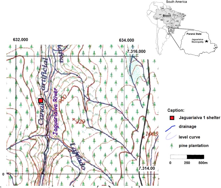
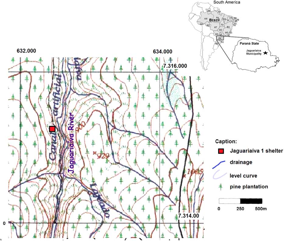
In Paraná State, southern Brazil (Figure 1), the first systematic studies of rockshelters were developed by the French archaeologists Annette Laming and Joseph Emperaire in 1954, when they analyzed grassland areas in the municipalities of Pirai do Sul and Tibagi in an area called Campos Gerais (Laming and Emperaire Reference Laming and Emperaire1956). Behling et al. (Reference Behling, Pillar, Orlóci and Bauermann2004) notes that grassland in southern Brazil was the main natural ecosystem present in this region before forest expansion in the Late Quaternary, and in Paraná State the people who did the first rock paintings lived in this kind of environment.
Location of Jaguariaíva 1 rockshelter in Jaguariaíva Municipality, in Paraná State, southern Brazil, based on topographic map of Barra Brava, IBGE 2001.
Rock paintings from central-eastern Paraná are usually red or brown, rarely black or yellow, and are mainly composed of figures of animals, such as deer in profile, alone or in groups, and birds, in profile or from the front, some moving. Less often we find lizards, snakes and frogs alongside and, in a few cases, fish figures have been registered. Human figures appear and are often depicted with animals and geometric symbols. There are various representations of animals in rows and with bars, as well as fishing scenes and people dancing in rituals and mythical scenes, as discussed in Parellada (Reference Parellada2015).
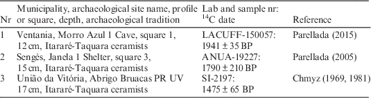
The majority of shelters with rock art in Paraná and Minas Gerais are usually associated with the Planalto rock art tradition (Jorge et al. Reference Jorge, Prous and Ribeiro2007). Archaeologists have identified and documented 150 shelters with rock art in Paraná State, the majority of which occur in areas of sandstone. Only a few shelters have been excavated, and even fewer have been radiocarbon (14C) dated, and those are clearly attributed to ceramists and farmers of Itararé-Taquara or Proto-Jê tradition (Table 1; Parellada Reference Parellada2009, Reference Parellada2015).
14C dates for rockshelters with rock art in Paraná State, southern Brazil.

In 2002, a salvage archaeological project occurred in the region along transmission lines between the substations at Bateias and Jaguariaíva (Figure 1), including survey of many areas with Furnas sandstone outcrops. Two new interesting shelters with cave paintings were identified and studied: Butia 1 and Jaguariaíva 1. In these shelters, paintings occur in both red and brown, and in Jaguariaíva 1 the images depict mostly figures of animals, such as deer, and geometric patterns (Parellada Reference Parellada2005). In this study, we discuss the 14C chronology of Jaguariaíva 1 archeological site, an important contribution to understanding human occupation in Paraná throughout the Holocene, particularly in sandstone shelters with rock art.
STUDY AREA: JAGUARIAÍVA ROCKSHELTER
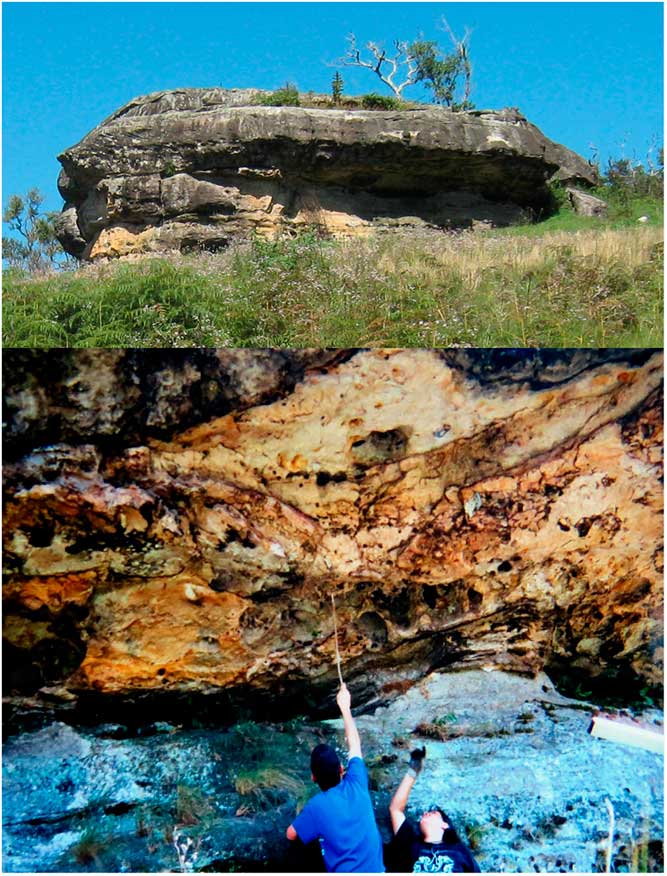
The Jaguariaíva 1 rockshelter (Figure 2) is located near the city of Jaguariaíva (Figure 1), Paraná State, Brazil. The site is located in the Meridional Plateau of South Brazil in a native grassland with Araucaria angustifolia (araucaria) conifers, though 20 years ago, the landscape was changed through the introduction of a pine plantation. The site is 17 × 21 × 5.21 m (length × width × height), with UTM coordinates at the central point E 632,454 m and N 7,315,244 m (horizontal datum SAD-69, originated in Ecuador and Central Meridian 39), and an altitude of 877 m. The shelter is 70 m of Guatelar artificial water channel and 90 m away from Jaguariaíva river, part of Itararé Hydrographic Basin.
Images of the north side of Jaguariaíva 1 shelter with pictographs on the wall and ceiling. Photo courtesy of Claudia Parellada.
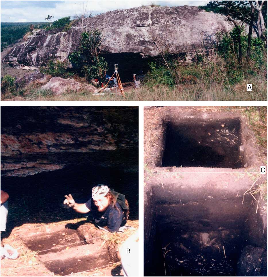
The site is a sandstone shelter with paintings from at least three different periods, as interpreted from the occurrence of superimpositions and identification of six levels of human occupation during excavations inside the shelter. In three levels, small fallen sandstone sections with rock art were identified (Figures 3, 4, and 7).
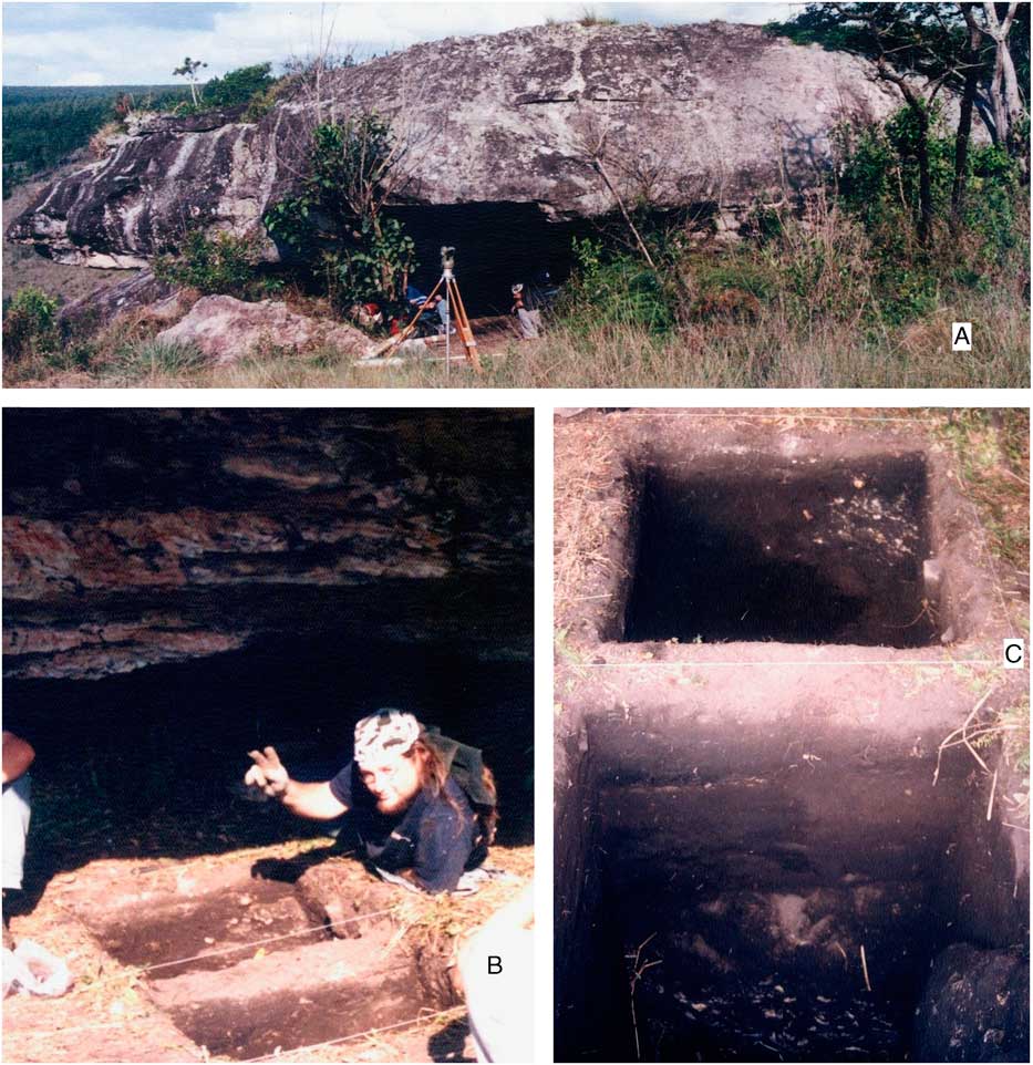
Images of the two test pits (C) excavated on the west side of Jaguariaíva 1 shelter (A), pit 2 is closer to the wall. Many red rock paintings are located on the wall above pit 2 (B). Photos courtesy of Claudia Parellada.
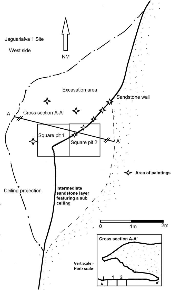
Map of the east side of Jaguariaíva 1 rockshelter, with areas of square pits and rock paintings.
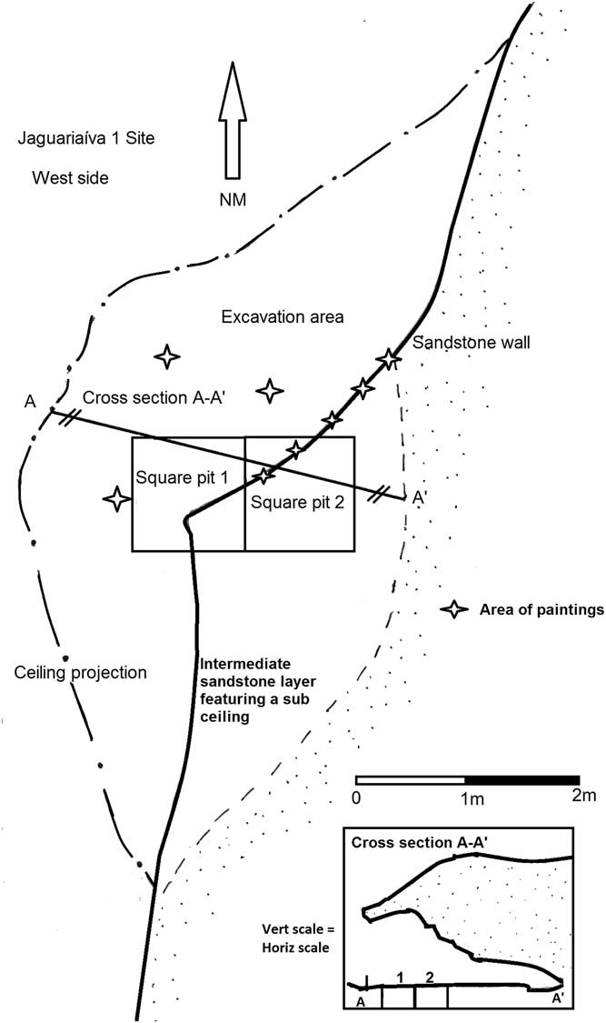
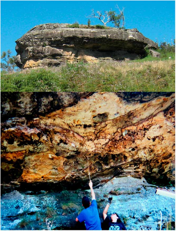
The paintings in Jaguariaíva 1 appear on the wall and ceiling of the shelter, from 0.5 m to 1.90 m tall on the west side, and 1.80 m to 3.60 m on the north face. In the main panel on the west side there are superimposed paintings of animals and bars (grilles). The oldest are large deer figures completely filled in with red. The more recent depictions are small reddish brown figures of animals with the head filled in and the body in silhouette, filled with dashes. Those pictographs could have been painted with small wood spatulas and using sticks of iron minerals as crayons, as observed through morphological analysis. On the north face, there are bars and human figures in red and circles filled in yellow or red that delimit small natural concavities in the sandstone configuring emblematic figures, which appear to be associated with the second phase of paintings.
The second and third phases of rock art, such as the dotted paintings and small animals in silhouette appear to be correlated with Itararé-Taquara ceramist groups, as are observed in others rockshelters with paintings in Paraná State, especially in sites with funerary structures (Parellada Reference Parellada2009). The red animal figures completely filled in with red were probably associated with Umbu hunters, as the fallen painted sandstone in the oldest layer indicates. In the south of Brazil the earliest peoples were related to Umbu tradition and Paleoindian (Parellada Reference Parellada2005).
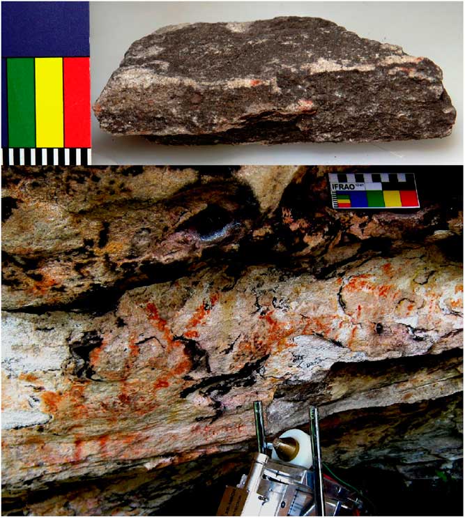
In the subsurface layers of Jaguariaíva 1, mixed with the sediments we found rich clayey concretions in iron, as well as hematite, limonite and goethite. Fallen painted sandstone sections in Jaguariaíva 1 are associated with levels 1, 3, and 4, a few with almost completely erased paintings and different types of iron minerals with traces of different colors in excavated levels. The superimpositions of the paintings as well as varying techniques of doing the paintings suggest three phases of paintings.
Minerals with iron oxides were often used to make red and yellow pigments, and manganese associated with organic matter was used to produce black in rock paintings of Jaguariaíva 1 shelter as demonstrated through X-ray fluorescence analysis (Appoloni et al. Reference Appoloni, Lopes, Melquíades and Parellada2010).
Two square adjacent test pits of 1 × 1 m were dug on the west side of Jaguariaíva 1 shelter to varying depths until reaching the Furnas sandstone layer (Figures 3–5). In these two excavation pits, we collected several sandstone fragments with paintings, between 0.40 and 0.85 m deep, which probably fell from the ceiling or walls in the past. The sedimentary matrix recovered from these pits was screened with a mesh size of less than 2 mm. In the northwestern part of pit 1, we reached rock at a depth of only 1.27 m with the occurrence of lithic artifacts, such as chips and projectile points in silexite and rock crystal quartz associated with Umbu hunter-gatherers, up to the maximum depth. Itararé-Taquara ceramic sherds and lithic artifacts in silexite and sandstone, related to Jê ancestral indigenous groups, were recovered between 0.15 and 0.72 m in pit 1, correlating to at least four different layers of occupation (Figures 3, 4, and 5).
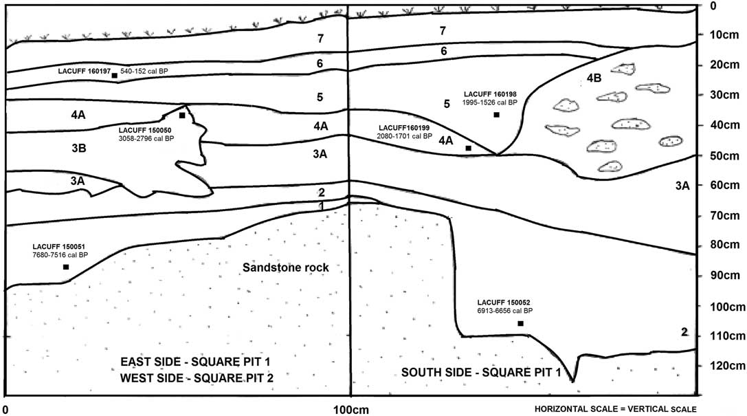
Stratigraphic profiles of east and south sides of pit 1, associated with west side of pit 2, excavated from the Jaguariaíva 1 rockshelter, indicating relative positions of samples for AMS 14C dating.
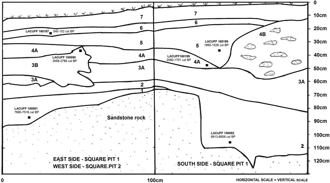
The stratigraphic profiles in pits 1 and 2 show sub-horizontal to lenticular layers, with six different levels of human occupation and a superficial disturbed layer. The layers have different extent and distribution and in layer 4 we identified a cremation structure in association with a fallen painted sandstone section.
In pit 2, a very rusty 100 “réis” coin was recovered from a fire structure. The coin is composed of 25% nickel and 75% copper, as was common between 1871 and 1888. On one face the words “September 3, 1870” can be read. The presence of this coin together with recent tile and glass fragments shows that the area was disturbed by humans during the 19th and 20th centuries.
MATERIALS AND METHODS
During excavation, we collected charcoal samples from pits 1 and 2. In the field, pit 1 was subdivided because of many imbrications and constriction of some layers. A total of five charcoal samples were used from pit 1 and one from pit 2. The stratigraphic profile of pit 1 is presented in Figure 5. A total of six charcoal samples were pretreated at the Radiocarbon Laboratory of the Fluminense Federal University (LAC-UFF). Because all six samples were collected from archeological site in plastic bags with different matrices, such as soil and sediment, the charcoal was physically pretreated to remove impurities such as roots, seeds, etc.
An acid-base-acid (ABA) treatment was used at 90°C with 1M of hydrochloric acid (HCl) and 1M of sodium hydroxide (NaOH). Charcoal samples were converted to CO2 by combustion in sealed quartz tubes, containing previously heated cupric oxide (Fisher Scientific, carbon compounds 0.0004%) and silver wire (Aldrich ≥99.99% 0.5 mm diameter), at 900°C for 3 hr. (Macario et al. Reference Macario, Gomes, Anjos, Carvalho, Linares, Alves, Oliveira, Castro, Chanca, Silveira, Pessenda, Moraes, Campos and Cherkinsky2013). All gas samples were cryogenically purified by dry ice/ethanol traps in a stainless steel sample preparation line and kept under vacuum at 1.0 mTorr line (Macario et al. Reference Macario, Oliveira, Carvalho, Santos, Xu, Chanca, Alves, Jou, Oliveira, Pereira, Moreira, Muniz, Linares, Gomes, Anjos, Castro, Anjos, Marques and Rodrigues2015). Graphitization was performed using tubes made from borosilicate glass, with 10–15 mg of titanium hydride; TiH2 (Alfa Aesar 99%) and 30–35 mg of Zinc and a 6-mm-OD Durham tube, which sits inside the larger reaction tube, with 3–5mg of iron powder catalyst into Pyrex® (Alfa Aesar -325 mesh, reduced, 98%) (Macario et al. Reference Macario, Oliveira, Carvalho, Santos, Xu, Chanca, Alves, Jou, Oliveira, Pereira, Moreira, Muniz, Linares, Gomes, Anjos, Castro, Anjos, Marques and Rodrigues2015). Each sample was split in a vacuum line in two graphitization tubes. The tubes containing reagents and gas samples were heated at 550°C for 7 hr. Graphite samples produced in each tube varied between 0.7 and 1 mg C.
Samples were pressed into Al targets (cathodes) in the wheel of the SNICS (source of negative ions by cesium sputtering) ion source and measured in a NEC 250kV single stage accelerator system (SSAMS) at the Physics Institute, in Niteroi, Rio de Janeiro State, Brazil. Calibration was performed with the software OxCal v4.2.4 (Bronk Ramsey Reference Bronk Ramsey2009) using the Southern Hemisphere atmospheric curve SHCal13 (Hogg et al. Reference Hogg, Hua, Blackwell, Niu, Buck, Guilderson, Heaton, Palmer, Reimer, Reimer, Turney and Zimmerman2013).
RESULTS AND DISCUSSION
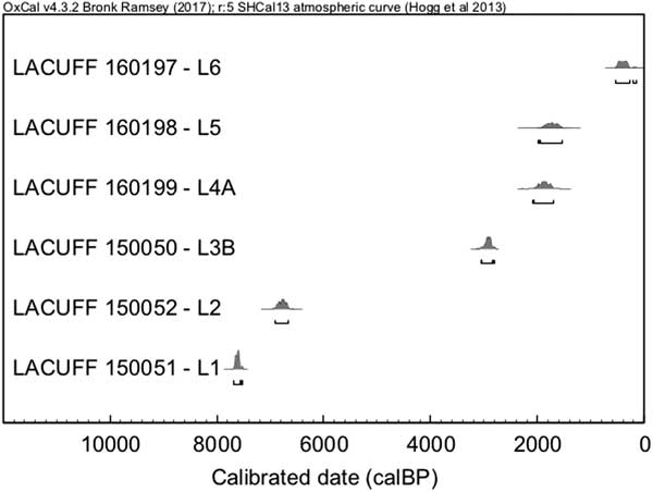
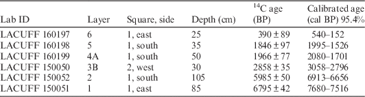
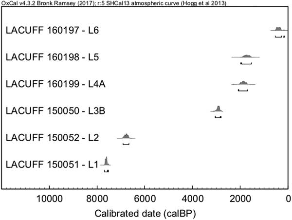
The results for the 14C and calibrated ages of the six charcoal samples analyzed are presented in Table 2. Probability distributions of the calibrated ages are displayed in Figure 6.
Probability distributions of calibrated ages obtained for Jaguariaíva 1 rockshelter.
AMS 14C dates and calibrated intervals obtained for the Jaguariaíva 1 rockshelter subsurface, in figure 5 the relative positions of samples are placed.

The stratigraphy of the Jaguariaíva 1 rockshelter site includes two horizons of Umbu—layers 1 and 2, and four Itararé-Taquara occupations—layers 3B, 4A, 5 and 6, plus a recent occupation with mixed materials related to the 19th and 20th centuries.
Layer 1, the first human occupation at the shelter, was characterized on the east side of pit 1 and was resting on Furnas white sandstone comprising a dark, greyish-brown to black sedimentary matrix with loamy sandy texture, and many fragments of hematite and goethite, as well as several lithic artifacts with Umbu operative chain and technological system. Layer 2 was identified on the south side of pit 1 in greater depth resting on Furnas sandstone, though in the east side occurred above layer 1. The stratum 2 is linked also with Umbu hunters and is comprised of a light gray sedimentary matrix with a loamy texture, and many pieces of charcoal and a wide variety of small lithic artifacts. Layers 1 and 2 had different extent and distribution, but the profile on the east side of pit 1 showed superpositional relationships.
We identified four intermediary occupations, layers 3(A-B), 4(A-B), 5 and 6, by groups of farmers and ceramists related to the Jê linguistic family, and likely related to the Itararé-Taquara archeological tradition. The Jê people made thin-walled ceramic vessels, with a distinct method of manufacturing called “paddle-and-anvil” or “paleteado,” some of which show the use of a temper made of freshwater sponge spicules and fragments of bark of calcined trees (“cariapé”), an extremely uncommon practice for this ceramic tradition (Parellada Reference Parellada2005; Araujo et al. Reference Araujo, Ortega, Shrage, Okumura and Ceccantini2016; Kalinovski et al. Reference Kalinovski, Parolin and Souza Filho2016).
The third occupation at the rockshelter corresponds to layer 3, divided into 3A to the part of the stratum with brown grayish sediments, loamy sandy texture and the majority archeological evidences and 3B to a fire structure that was dated to 3058–2796 cal BP. 3B had dark gray to black sediments with many pieces of charcoal and charred small coconuts. At stratigraphic profile of the east side of pit 1 an erosive discordance was documented and related to the fire structure that cut the layer 2 and part of 3A, resulting irregular limits.
Layer 4 was divided into subsections 4A and 4B. 4A is typified by light brown grayish sediments, sandy texture and a cremation structure, dated to 2080–1701 cal BP, whereas 4B, is a fire structure with many pieces of charcoal and sandstone. The layer 4A/4B had lenticular geometry and was partially cut by a fire structure of layer 5. Layer 5, dated to 1995–1526 cal BP, had brown grayish sediments with sandy loamy texture, many pieces of charcoal, and some lithic artifacts and ceramic sherds. The relation between layers 5 and 6 was horizontal. Layer 6, dated to 540–152 cal BP, was characterized by gray sediments with sandy texture, many pieces of charcoal and sandstone, beyond some ceramic sherds and a few lithic artifacts.
Behling et al. (Reference Behling, Pillar, Orlóci and Bauermann2004) note that the highlands of southern Brazil at 7400 cal BP were dominated by grasslands, with a drier and colder climate than current-day conditions, possibly 10ºC cooler. In this climate, araucaria pines were probably restricted to deep valleys and more humid coastal slopes. The first two Umbu occupations of Jaguariaíva 1 shelter—layers 1 and 2—happened within this environment, and the subsistence of these people occurred with the resources of this colder climate.
According to Moro et al. (Reference Moro, Gomes and Pereira2012), araucaria species expanded across the grasslands in the Campos Gerais region, in the Paraná State, southern Brazil, into gallery forest networks at about 4320 cal BP. On the other hand, the four Itararé-Taquara or Proto-Jê occupations of Jaguariaíva 1 rockshelter were already in these conditions, with a wider variety of natural resources, including more available water.
It is important to emphasize that in this shelter we have one of the oldest dated occupations for a Proto-Jê tradition site in Paraná 3058–2796 cal BP 95.4% (Layer 3B). The charcoal was sampled inside the layer in a fire structure. The other dates fall into two compact clusters that correlate well with the stratigraphy. Layers 4 and 5 were dated to 2080–1701 cal BP and 1995–1526 cal BP, contemporary to other dates obtained for rockshelters in the region (Table 1). The two oldest occupations are from Umbu hunter-gatherers, the earliest and deepest dated to 7680–7516 cal BP (Layer 1) and the other to 6913–6656 cal BP (Layer 2). This chronology confirms the interpretative hypotheses observed during field excavation that Layers 1 and 2 belong to different occupations. Raw materials for lithics and ceramics were available from backwaters of Jaguariaíva river, located near the rockshelter.
CONCLUSIONS
Archeological sites in rockshelters are an important resource in understanding human occupation in Southern Brazil. Although more than 150 sites have been registered in Paraná State alone, few have been systematically studied or dated.
The Jaguariaíva 1 rockshelter is a significant site that requires further in depth study, as it is one of the few documented sites that shows occupation by both Umbu hunter-gatherer as well as ceramic producing Jê in the region. The site was occupied several times, showing repeated human settlements during variable environmental conditions, and the analysis of the samples enabled us to evaluate changes of subsistence patterns, food, and raw materials over time.
Fallen rock art associated with three separate occupations were identified from this site. Layer 1 represents remains from the first occupation by Umbu hunters in Jaguariaíva shelter and the oldest 14C dating of Umbu tradition in Northeast of Paraná, with artifacts including debitage, flakes, projectile points and small scrapers, mainly in silexite and rock crystal quartz. This layer also included fragments of goethite and limonite, probably used to paint large figures of animals in red in rockshelter.
A second occupation layer including chert and quartz artifacts, with several fragments of charcoal and a fallen painted sandstone section was also identified. This layer allowed us to identify occupation by Umbu hunters. A third occupation at Jaguariaíva 1 shelter corresponds to the oldest Itararé-Taquara occupation, with many fragments of thin-walled ceramics, some with sponge spicules, and lithics such as hammerstones, crystalline quartz flakes, and many pieces of charcoal and some botanical macrofossil remains.
In addition to the rock art, sediments of Layer 4 at this site are associated with Itararé-Taquara ceramists and inside pit 2 a cremation structure was documented, with many fragments of ochre and few ceramic sherds. A piece of fallen sandstone with rock art, and a rock anvil with ground dye—iron oxides were recovered from this pit, where these dyes may have been used for body paintings and coloring objects. The Jê people associated with layer 4 or 5 could be the painters of yellow and red circles on the north side of the shelter and barred lines and bars/grilles on the west side, especially the people related to layer 4 because of the funerary structure.
The fifth and sixth human occupations of Jaguariaíva 1 site were also linked to Itararé-Taquara farmers. Level six could be associated with a third phase of paintings such as small deer in sillouette and reddish brown outline figures filled with straight lines. It appears that the Itararé-Taquara ceramists entered the region only after the expansion of the araucaria forests due to warmer and more humid climatic conditions, favoring the development of a maize and tuber agriculture with the exploitation of Araucaria pine nut, pitanga fruit, palm tree nuts, among other native species.
The conservation and management of important archeological sites, such as Jaguariaíva 1 rockshelter, require comprehensive and multidisciplinary studies in order to better understand past societies and support the preservation of this cultural heritage. The chronological records are fundamental to having a consistent and contextual study in archeology.
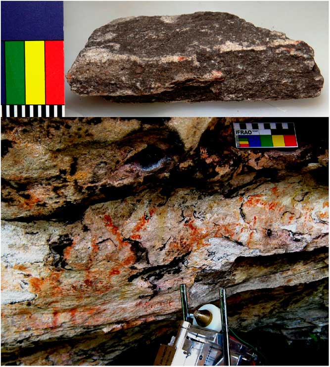
Images of fallen sandstone section with rock art from layer 1 of east side of pit 1, and part of wall-ceiling with rock paintings over pit 1. Photos courtesy of Claudia Parellada.
ACKNOWLEDGMENTS
The authors would like to thank Brazilian funding agencies FAPERJ (Fundação Carlos Chagas Filho de Amparo à Pesquisa do Estado do Rio de Janeiro) and CNPq (Conselho Nacional de Desenvolvimento Científico e Tecnológico) for Fabio Lopes post-doctoral fellowship (150493/2015-0), Kita Macario productivity fellowship (305079/2014-0) and INCT-FNA (464898/2014-5). We thank the Brazilian Ministry of Culture and IPHAN for granting permission for the fieldwork and analysis of samples for dating, and Copel for financial support to undertake part of the archeological research. We also thank all team members of the Archaeology Department of Paranaense Museum, especially Patricia Depine and Ricardo Braga for fieldwork, and Dr. Evelyn R. Nimmo and Andras Jucksch Ellendersen for reviewing the manuscript. We also thank Fernando Willcock and Dr. Mauro Parolin for discussions about the rockshelter. We are grateful to the reviewers and editors Warren Beck and Tim Jull for comments and suggestions that helped to improve the paper.