1. Introduction
The Central Asian Orogenic Belt (CAOB), also referred to as the Altaid collage or the Altaids, is situated among the Siberia, East European, Tarim and North China cratons (Sengör, Natalin & Burtman, Reference Sengör, Natalin and Burtman1993; Sengör & Natalin, Reference Sengör and Natalin1996; Jahn, Wu & Chen, Reference Jahn, Wu and Chen2000a; Badarch, Cunningham & Windley, Reference Badarch, Cunningham and Windley2002; Jahn et al. Reference Jahn, Capdevila, Liu, Vernon and Badarch2004a; Yakubchuk, Reference Yakubchuk2004). It is one of the largest orogenic collages in the world which preserves important evidence for accretionary orogenesis and Phanerozoic continental growth (Sengör, Natalin & Burtman, Reference Sengör, Natalin and Burtman1993; Hu et al. Reference Hu, Jahn, Zhang, Chen and Zhang2000; Jahn, Wu & Chen, Reference Jahn, Wu and Chen2000a,b; Jahn et al. Reference Jahn, Capdevila, Liu, Vernon and Badarch2004a; Chen & Jahn, Reference Chen and Jahn2004; Ota et al. Reference Ota, Utsunomiya, Uchio, Isozaki, Buslov, Ishikawa, Maruyama, Kitajima, Kaneko, Yamamoto and Katayama2007; Safonova et al. Reference Safonova, Utsunomiya, Kojima, Nakae, Tomurtogoo, Filippov and Koizumi2009, Reference Safonova, Sennikov, Komiya, Bychkova and Kurganskaya2011a,b, Reference Safonova, Simonov, Obut, Kurganskaya, Romer and Seltmann2012; Kröner et al. Reference Kröner, Alexeiev, Rojas-Agramonte, Hegner, Wong, Xia, Belousova, Mikolaichuk, Seltmann, Liu and Kiselev2013; Safonova & Santosh, Reference Safonova and Santosh2014; Xiao et al. Reference Xiao, Sun and Santosh2015; Xiao, Sun & Santosh, Reference Xiao, Sun and Santosh2015). The CAOB is generally thought to be related to the closure of the Palaeo-Asian Ocean from Early Neoproterozoic to Late Palaeozoic times (Khain et al. Reference Khain, Bibikova, Kroner, Zhuravlev, Sklyarov, Fedotova and Kravchenko-Berezhnoy2002; Dobretsov, Buslov & Vernikovsky, Reference Dobretsov, Buslov and Vernikovsky2003; Buckman & Aitchison, Reference Buckman, Aitchison, Malpas, Fletcher and Aitchison2004; Kovalenko et al. Reference Kovalenko, Yarmolyuk, Kovach, Kotov, Kozakov, Salnikova and Larin2004; Windley et al. Reference Windley, Alexeiev, Xiao, Kröner and Badarch2007; Xiao et al. Reference Xiao, Windley, Huang, Han, Yuan, Chen, Sun, Sun and Li2009; Wilhem, Windley & Stampfli, Reference Wilhem, Windley and Stampfli2012), and it was mainly formed through subduction, terrane accretion, craton collision and post-collisional extension from Neoproterozoic to end Palaeozoic times (Chen & Jahn, Reference Chen and Jahn2004; Windley et al. Reference Windley, Alexeiev, Xiao, Kröner and Badarch2007; Xiao et al. Reference Xiao, Windley, Huang, Han, Yuan, Chen, Sun, Sun and Li2009, Reference Xiao, Huang, Han, Sun and Li2010b; Biske & Seltmann, Reference Biske and Seltmann2010); this involved the accretion of oceanic islands, seamounts, oceanic plateaus, island arcs, accretionary complexes, ophiolites and microcontinents to the southern margin of the Siberian Craton (Coleman, Reference Coleman1989; Feng et al. Reference Feng, Coleman, Tilton and Xiao1989; Buslov et al. Reference Buslov, Safonova, Watanabe, Obut, Fujiwara, Iwata, Semakov, Sugai, Smirnova, Kazansky and Itaya2001, Reference Buslov, Fujiwara, Iwata and Semakov2004; Windley et al. Reference Windley, Alexeiev, Xiao, Kröner and Badarch2007; Xiao et al. Reference Xiao, Han, Yuan, Sun, Zhao, Shan, Kusky, Zhai and Xiao2010a,Reference Xiao, Windley, Allen and Han2013; Xiao & Santosh, Reference Xiao and Santosh2014; Zhu, Chen & Qiu, Reference Zhu, Chen and Qiu2015).
West Junggar is located in the southern part of the CAOB and is characterized by widespread Palaeozoic magmatism and deformation, which provides an ideal natural laboratory to study the orogenic and accretionary characteristics of the CAOB (Feng et al. Reference Feng, Coleman, Tilton and Xiao1989; Zhang et al. Reference Zhang, Zhai, Allen, Saunders, Wang and Huang1993; Zhang, Huang & Zhai, Reference Zhang, Huang and Zhai1995; Xiao et al. Reference Xiao, Han, Yuan, Sun, Lin, Chen, Li, Li and Sun2008). It is considered to be one of the critical areas for the study of the amalgamation history of the CAOB and the evolution of the Palaeo-Asian Ocean (Sengör, Natalin & Burtman, Reference Sengör, Natalin and Burtman1993; Jahn, Wu & Chen, Reference Jahn, Wu and Chen2000a; Xiao et al. Reference Xiao, Windley, Badarch, Sun, Li, Qin and Wang2004, Reference Xiao, Han, Yuan, Sun, Lin, Chen, Li, Li and Sun2008; Choulet et al. Reference Choulet, Chen, Wang, Faure, Cluzel, Charvet, Lin and Xu2011; Wilhem, Windley & Stampfli, Reference Wilhem, Windley and Stampfli2012; Yang et al. Reference Yang, Li, Xiao and Tong2015). However, the mechanism of tectonic evolution in West Junggar remains controversial and is currently under debate; proposed are models of single subduction–accretion processes (Wang et al. Reference Wang, Sun, Li, Hou, Qin, Xiao and Hao2003), arc–arc collisions (Zhang, Huang & Zhai, Reference Zhang, Huang and Zhai1995; Buckman & Aitchison, Reference Buckman, Aitchison, Malpas, Fletcher and Aitchison2004), remnant ocean filling (Chen & Guo, Reference Chen and Guo2010; Chen et al. Reference Chen, Guo, Pe-Piper and Zhu2013; Xu et al. Reference Xu, Ji, Zhao, Gong, Zhou, He, Zhong, Wang and Griffiths2013), post-collisions (Han et al. Reference Han, Ji, Song, Chen and Zhang2006; Zhou et al. Reference Zhou, Yuan, Fan, Zhang, Cooke and Zhao2008; Chen et al. Reference Chen, Han, Ji, Zhang, Xu, He and Wang2010) and intra-oceanic subduction or oceanic-ridge subduction (Xiao et al. Reference Xiao, Han, Yuan, Sun, Lin, Chen, Li, Li and Sun2008; Geng et al. Reference Geng, Sun, Yuan, Xiao, Xian, Zhao, Zhang, Wong and Wu2009; Liu et al. Reference Liu, Xu, Wang, Hou, Bai and Lei2009; Tang et al. Reference Tang, Wang, Wyman, Li, Zhao, Jia and Jiang2010, Reference Tang, Wang, Wyman, Li, Zhao and Yang2012a; Ma et al. Reference Ma, Xiao, Windley, Zhao, Han, Zhang, Luo and Li2012; Yang et al. Reference Yang, Li, Gu, Tong and Zhang2012a,b,c; Yin et al. Reference Yin, Long, Yuan, Sun, Zhao and Geng2013, Reference Yin, Chen, Yuan, Yu, Xiao, Long, Li and Sun2015; Li et al. Reference Li, He, Ma, Tang, Kong and Tang2015a,b). Regardless of these models, Zhang & Zhang (Reference Zhang and Zhang2014) first reported the A1-type Baiyanghe granite, which is characterized by element ratios similar to ocean-island basalts (OIB) and derived from sources such as OIB, but was related to continental rifts or extensional zones in intra-plate settings (Eby, Reference Eby1992) in West Junggar. Subsequently, Gao et al. (Reference Gao, Xiao, Pirajno, Wang, He, Yang and Yan2014) suggested that the Phanerozoic CAOB granitoids could be related to a mantle plume. This has been further supported by Yang et al. (Reference Yang, Li, Xiao and Tong2015), who considered that the OIB-type rocks in ophiolitic mélanges from West Junggar are fragments of accreted seamounts, which may indicate that the plume-related magmatism occurred within the Palaeo-Asian Ocean. In general, a series of studies imply that an ancient mantle plume probably existed in West Junggar. However, direct and convincing evidence for this mantle plume is still lacking.
The Baiyanghe granite is a unique A1-type granite in northern West Junggar and has been considered petrogenetically associated with OIB-like magmatism (Zhang & Zhang, Reference Zhang and Zhang2014). In the field, some dolerite dykes have intruded the Baiyanghe granite, and they show a close relationship with the granite in time and space. Thus, these dolerites may be of vital tectonic significance for the interpretation of the Late Palaeozoic tectonic setting of West Junggar, especially for revealing the mechanism of the OIB-like magmatism. However, a detailed study of the dolerites from a geochemical and geochronological perspective has not been available to date. Considering this, we hereby present data that we collected during our in-depth study of the Baiyanghe dolerites using field, petrological, geochronological and geochemical techniques. These new data, in combination with available regional geological data, are crucial for understanding the tectonic evolution and geodynamics of West Junggar.
2. Geological setting
2.a. Geology of West Junggar
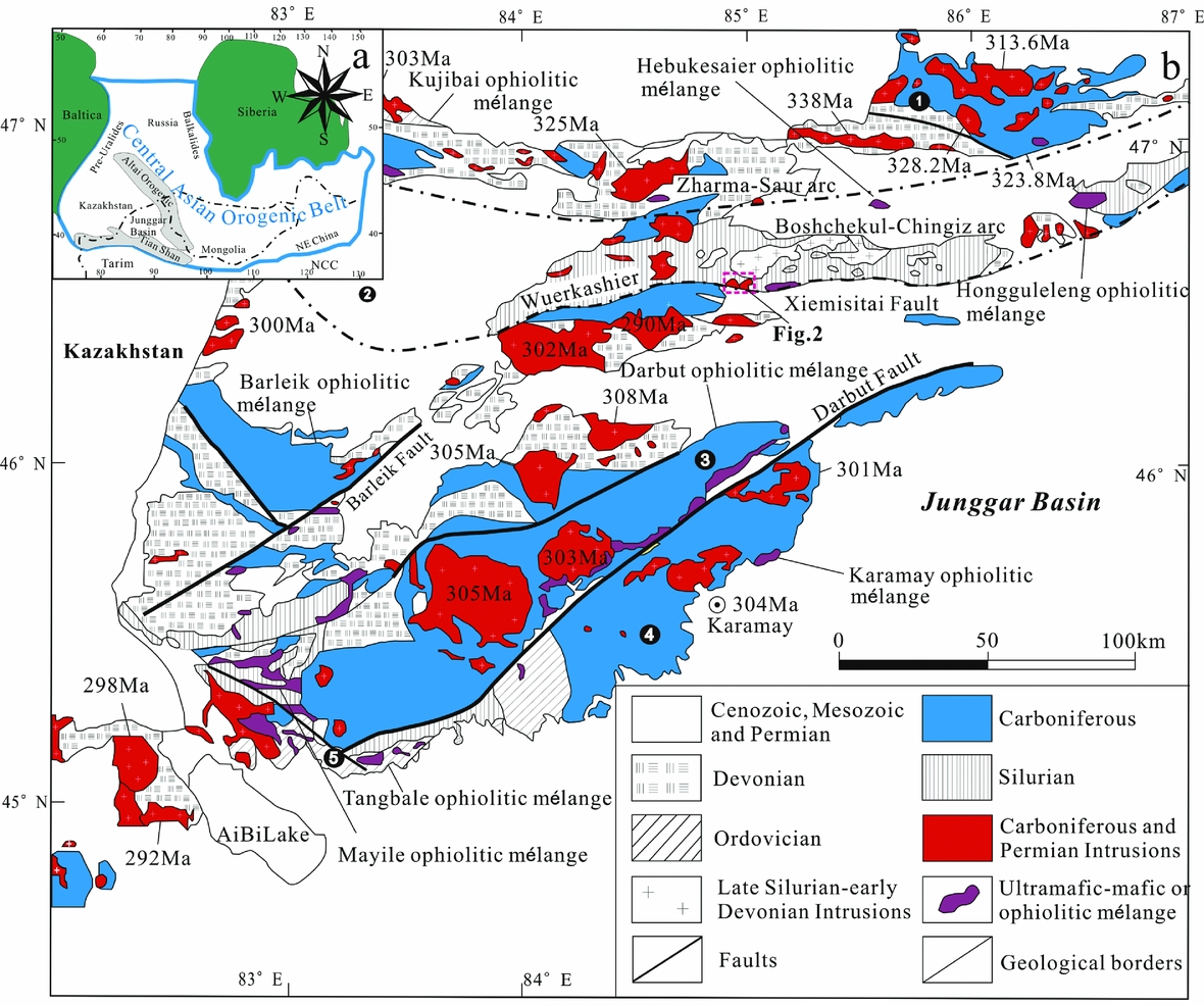
West Junggar, located in the northern Xinjiang Uygur Autonomous Region (NW China), is surrounded by the Altai orogeny to the north, the Tianshan orogen to the south, the Kazakhstan block to the west and the Junggar basin to the east (Fig. 1a; Geng et al. Reference Geng, Sun, Yuan, Xiao, Xian, Zhao, Zhang, Wong and Wu2009; Chen et al. Reference Chen, Han, Ji, Zhang, Xu, He and Wang2010; Chen, Han & Zhang, Reference Chen, Han and Zhang2010; Tang et al. Reference Tang, Wang, Wyman, Li, Zhao, Jia and Jiang2010; Geng et al. Reference Geng, Sun, Yuan, Zhao and Xiao2011; Zhang et al. Reference Zhang, Xiao, Han, Ao, Yuan, Sun, Geng, Zhao, Guo and Ma2011a,b; Shen et al. Reference Shen, Shen, Li, Pan, Zhu, Meng and Dai2012).
(a) Geological map of the Central Asian Orogenic Belt (modified after Jahn et al. Reference Jahn, Windley, Natalin and Dobretsov2004b; Windley et al. Reference Windley, Alexeiev, Xiao, Kröner and Badarch2007). (b) Simplified geological map of West Junggar and the adjacent Junggar basin in northern Xinjiang. Modified after BGMRXUAR (1993) and Yang et al. (Reference Yang, Li, Yan, Tong, Han and Wang2014b).

West Junggar can be divided into southern and northern parts (Fig. 1b; Geng et al. Reference Geng, Sun, Yuan, Xiao, Xian, Zhao, Zhang, Wong and Wu2009; Chen et al. Reference Chen, Han, Ji, Zhang, Xu, He and Wang2010; Chen, Han & Zhang, Reference Chen, Han and Zhang2010; Yang et al. Reference Yang, Li, Gu, Tong and Zhang2012a). The southern part of West Junggar is characterized by occurrences of Early Palaeozoic island arcs and supra-subduction zone (SSZ)-type ophiolitic mélanges in the Tangbale, Mayile and Barleik regions (Xu et al. Reference Xu, Ji, Zhao, Gong, Zhou, He, Zhong, Wang and Griffiths2013; Ren et al. Reference Ren, Han, Xu, Zhou, Liu, Zhang, Chen, Su, Li, Li and Li2014). It consists mainly of Ordovician–Devonian volcano-sedimentary sequences and sporadic slices of Early Palaeozoic ophiolitic mélanges and a Neoproterozoic seamount (Xu et al. Reference Xu, Han, Ren, Zhou, Zhang, Chen, Su, Li and Liu2012, Reference Xu, Ji, Zhao, Gong, Zhou, He, Zhong, Wang and Griffiths2013; Yang et al. Reference Yang, Li, Santosh, Yang, Yan, Zhang and Tong2012c; Ren et al. Reference Ren, Han, Xu, Zhou, Liu, Zhang, Chen, Su, Li, Li and Li2014). The northern part mainly includes the NW-trending Zharma-Saur and Boshchekul-Chingiz volcanic arcs, with Palaeozoic lithostratigraphy ranging from the Cambrian to Permian (Fig. 1b; Didenko & Morozov, Reference Didenko and Morozov1999; Vladimirov et al. Reference Vladimirov, Kruk, Khromykh, Polyansky, Chervov, Vladimirov, Travin, Babin, Kuibida and Khomyakov2008; Shen et al. Reference Shen, Shen, Li, Pan, Zhu, Meng and Dai2012). The Late Palaeozoic Zharma-Saur arc (346–321 Ma; Chen et al. Reference Chen, Han, Ji, Zhang, Xu, He and Wang2010; Zhao & He, Reference Zhao and He2013) is adjacent to the Irtysh-Zaysan suture zone to the north, characterized by massive Late Devonian – Early Carboniferous subduction-related volcanic and I-type granitoids (Chen, Han & Zhang, Reference Chen, Han and Zhang2010), which were mainly formed by southward subduction of the Irtysh-Zaysan oceanic lithosphere during Late Devonian – Early Carboniferous times (Windley et al. Reference Windley, Alexeiev, Xiao, Kröner and Badarch2007; Vladimirov et al. Reference Vladimirov, Kruk, Khromykh, Polyansky, Chervov, Vladimirov, Travin, Babin, Kuibida and Khomyakov2008; Chen et al. Reference Chen, Han, Ji, Zhang, Xu, He and Wang2010; Chen, Han & Zhang, Reference Chen, Han and Zhang2010). To the south is the Early Palaeozoic Boshchekul-Chingiz arc (422–405 Ma; Chen, Han & Zhang, Reference Chen, Han and Zhang2010; Shen et al. Reference Shen, Shen, Li, Pan, Zhu, Meng and Dai2012; Yang et al. Reference Yang, Li, Safonova, Yi, Tong and Seltmann2014a), involving the Hongguleleng, Hebukesaier and Kujibai ophiolitic mélanges in West Junggar, and Zhaur and Barkbek ophiolitic mélanges in northern East Kazakhstan from east to west, which constitute the eastern part of the Arkalyk–Kujibai–Hongguleleng ophiolitic mélange belt and may represent an inter-arc (Filippova, Bush & Didenko, Reference Filippova, Bush and Didenko2001) or back-arc oceanic basin (Degtyarev, Reference Degtyarev2011). The pre-Carboniferous Kujibai–Hebukesaier–Hongguleleng ophiolitic mélanges (Jian et al. Reference Jian, Liu, Shi, Zhang and Sklyarov2005; Zhu & Xu, Reference Zhu and Xu2006; Zhang & Guo, Reference Zhang and Guo2010) lie in between the two volcanic arcs.
2.b. Geology of the Baiyanghe area
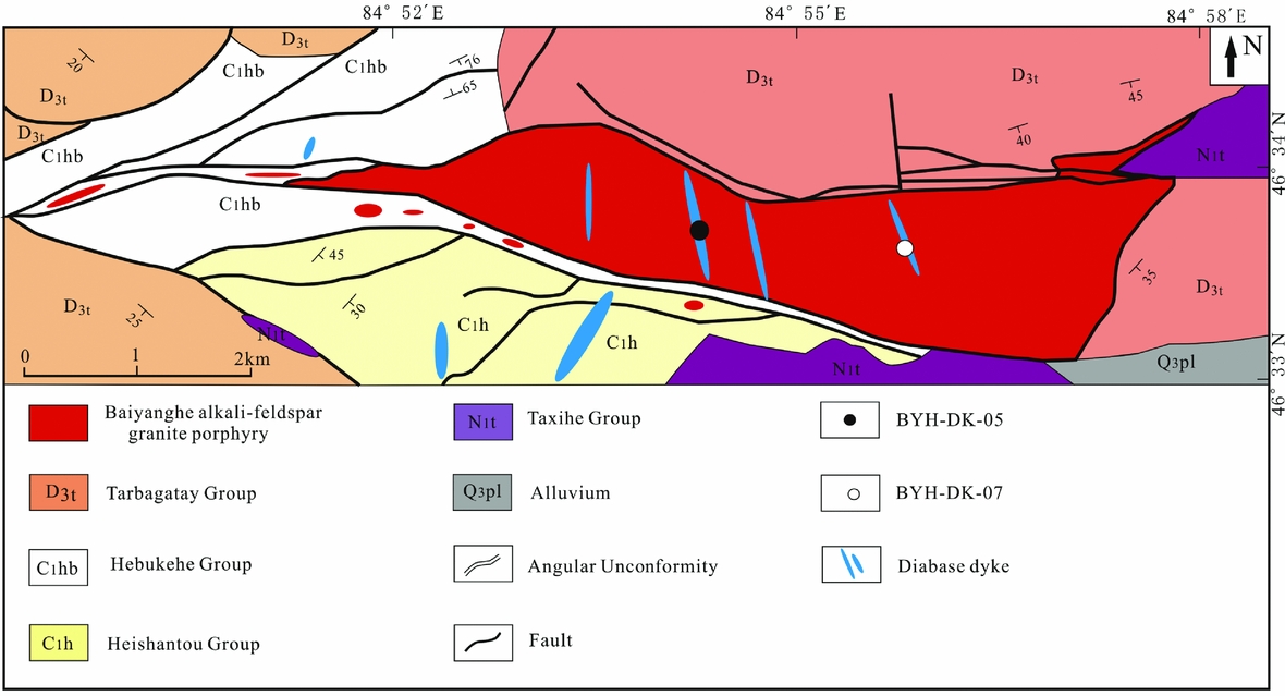
The Baiyanghe granite and our samples (the Baiyanghe dolerite) are 16.5 km to the northwest of Baiyanghe town, Hebukesaier County. The intrusions are close to the E–W-trending Xiemisitai fault (Fig. 2; Xiu et al. Reference Xiu, Fan, Ma and Yi2011; Wang et al. Reference Wang, Li, Guo, Li, Shi and Lu2012). In the studied area, the stratigraphic sequence mainly includes intermediate–acidic volcanic and pyroclastic rocks of the Late Devonian Tarbagatay Group; bioform limestone, conglomerate, siliceous shale and mudstone of the Lower Carboniferous Hebukehe Group; basic–intermediate volcanic and pyroclastic rocks of the Early Carboniferous Heishantou Group and mudstone of the Neogene Taxihe Group (Fig. 2; XBGMR, 1983; Wang et al. Reference Wang, Li, Guo, Li, Shi and Lu2012).
Geological sketch map of the Baiyanghe granite porphyry. Modified after XBGMR (1983) and Wang et al. (Reference Wang, Li, Guo, Li, Shi and Lu2012).

The Baiyanghe granite and dolerite are located in the central part of the Xiemistai Mountains and thus within the southeastern part of the Boshchekul–Chingiz volcanic arc (Fig. 1b). Many Middle Devonian volcanic rocks, formed in an island-arc setting, crop out in the Xiemistai Mountains (Wang, Reference Wang1996; He et al. Reference He, Chen, Xu, Li and Hao2004). The Middle Cambrian to Middle Silurian clastic rocks, volcanic rocks and pyroclastic sedimentary rocks in the Boshchekul–Chingiz volcanic arc (Yakubchuk & Degtyarev, Reference Yakubchuk and Degtyarev1998) formed a subduction-related volcano-sedimentary complex (Windley et al. Reference Windley, Alexeiev, Xiao, Kröner and Badarch2007).
3. Samples and analytical methods
To correctly characterize the chemical and isotopic compositions of the Baiyanghe dolerites, fresh samples were collected from the dykes. Sampling sites are shown in Figure 2. Bulk-rock samples were analysed for major- and trace-element contents, and Sr–Nd isotopic compositions. Zircon grains separated from the samples were analysed for U–Pb dating.
3.a. Major- and trace-element analyses
Analyses of major and trace elements were carried out in the State Key Laboratory of Ore Deposit Geochemistry, Institute of Geochemistry, Chinese Academy of Sciences (IGCAS). Major elements for samples were determined by using wavelength-dispersive X-ray fluorescence spectrometry with analytical deviations of less than 1%. LOI (loss on ignition) was obtained through heating 1 g of sample powder at 1100°C for 1 hour. Trace elements of the rocks were determined by using inductively coupled plasma mass spectrometry (ICP-MS) to analyse solutions of the samples digested by HF+HClO4 acid in bombs. The international standard GBPG-1 and the Chinese National Standard GSR-1 were applied to control analytical quality. Relative standard deviation was less than 10% for the determination of trace elements, including rare earth element (REE) contents. Sample preparation, instrument operating conditions and calibration procedures of Qi & Grégoire (Reference Qi and Grégoire2000) were applied.
3.b. Zircon U–Pb dating
Zircon grains from the Baiyanghe dolerites were concentrated using heavy-liquid and magnetic methods, and were then separated by handpicking under a binocular microscope at the State Key Laboratory of Ore Deposit Geochemistry, IGCAS. Zircon grains were then mounted in epoxy resin and polished down to near half sections. The zircon grains with clear and less fractured rims, examined using cathodoluminescence (CL) and optical microscopy, were selected as suitable targets for laser ablation analyses. Sample mounts were placed in a two-volume sample cell flushed with Ar and He. The laser ablation was operated at a constant energy of 80 mJ and at 8 Hz, with a spot diameter of 31 μm. The ablated material was carried by He gas to an Agilent 7500a ICP-MS for U–Pb isotopic analysis. Corrections were made for mass bias drift by reference to the standard glass NIST 610 (Pearce et al. Reference Pearce, Perkins, Westgate, Gorton, Jackson, Neal and Chenery1997). The Temora zircon was used as the age standard (206Pb/238U = 416.8 Ma) (Black et al. Reference Black, Kamo, Allen, Aleinikoff, Davis, Korsch and Foudoulis2003). Trace-element concentrations of U, Th and Pb were obtained by normalizing count rates for each analysed element to those for Si, and assuming SiO2 to be stoichiometric in zircon (Tu et al. Reference Tu, Hong, Deng, Ling, Liang, Liu and Sun2011). The apparent and discordant U–Pb ages were calculated by using the ISOPLOT program (Ludwig, Reference Ludwig2003). Uncertainties of individual analyses are reported with 1σ errors and the weighted mean 206Pb–238U ages are calculated at the 2σ confidence level.
3.c. Sr and Nd isotopes
For Rb–Sr and Sm–Nd isotope analyses, sample powders of bulk rocks were first spiked with mixed isotope tracers, and then dissolved in Teflon capsules with HF+HNO3 acid. The sample solutions were separated by a conventional cation-exchange technique. Rb–Sr and Sm–Nd isotopic measurements were then performed on the MAT-262 thermal ionization mass spectrometer (TIMS) at the State Key Laboratory of Ore Deposit Geochemistry, IGCAS. The mass fractionation corrections for Sr and Nd isotopic ratios were based on 0.1194 for 86Sr/88Sr and 0.7219 for 146Nd/144Nd, respectively. The analysed NBS987 standard is 0.710258±7 (2σ) for 87Sr/86Sr and La Jolla standard is 0.511841±3 (2σ) for 143Nd/144Nd (Li, Reference Li2009).
4. Results
4.a. Major-element geochemistry
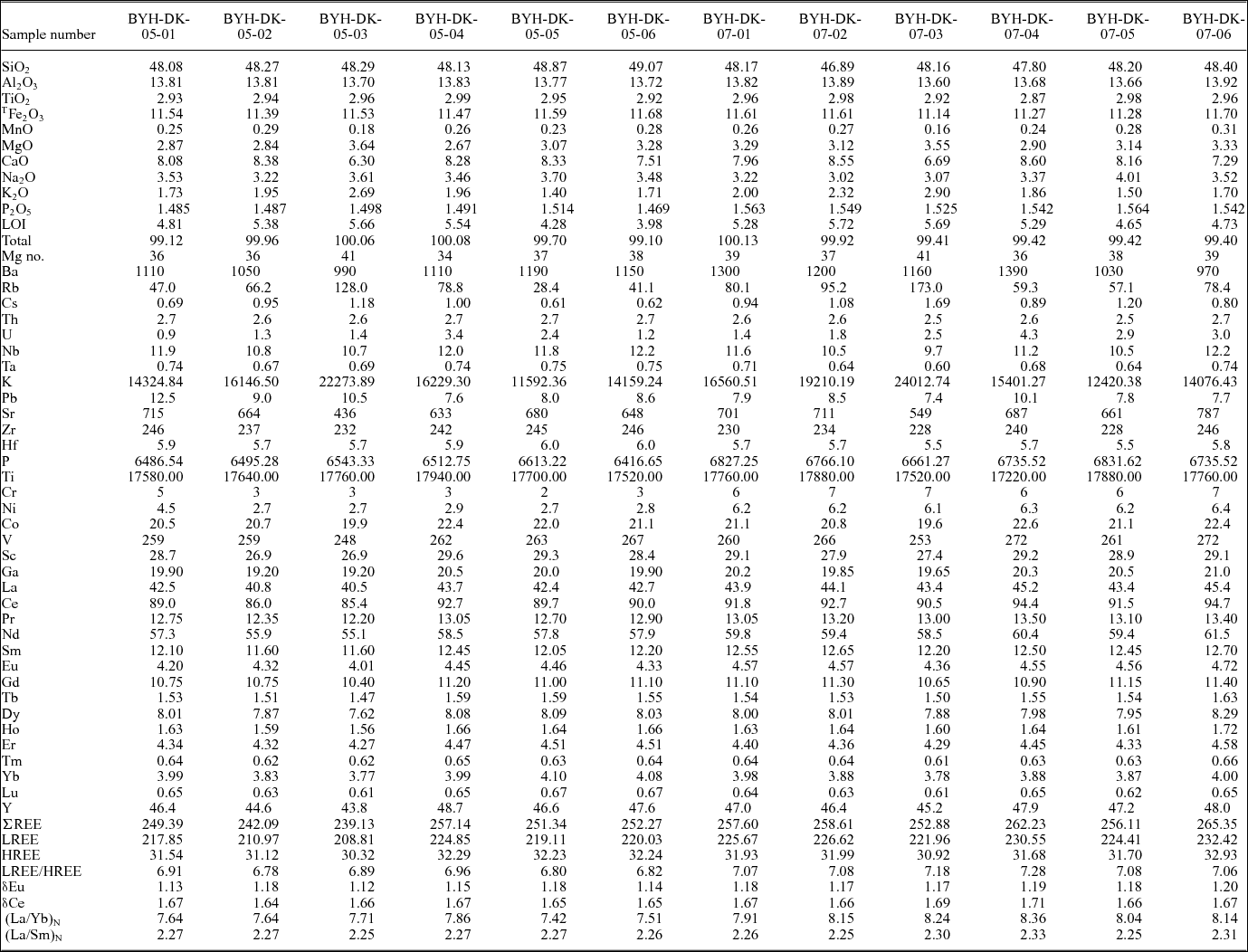
Major-element concentrations of the representative 12 dolerite samples are presented in Table 1. They show relatively high LOI values, which suggests a high degree of alteration. The samples of the Baiyanghe dolerite dykes are characterized by a slight variation in SiO2 (46.89–49.07 wt%), MnO (0.16–0.31 wt%) and TiO2 (2.87–2.98 wt%); high contents of Al2O3 (13.60–13.92 wt%) and total Fe2O3 (11.14–11.70 wt%); and low contents of MgO (2.67–3.64 wt%). The total alkali contents were Na2O+K2O, 5.10–5.97 wt%, K2O/Na2O = 0.37–0.94. Their relatively high CaO contents ranged between 6.30 wt% and 8.60 wt%. The Mg numbers (100(Mg2+/(Mg2++Fe2+)), 34–41) were relatively low.
Major- and trace-element compositions (in ppm) and parameters of the Baiyanghe dolerites

Note: LOI = Loss on ignition. Mg no. = 100 * Mg2+/(Mg2++Fe2+). Ti = ((M (Ti) / M (TiO2)) * A (TiO2) * 106; P = ((M(P) / M (P2O5)) * A (P2O5) * 106; M – the atomic mass of the element; A – the total mass of the compound.
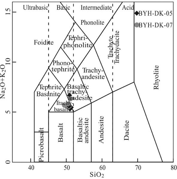
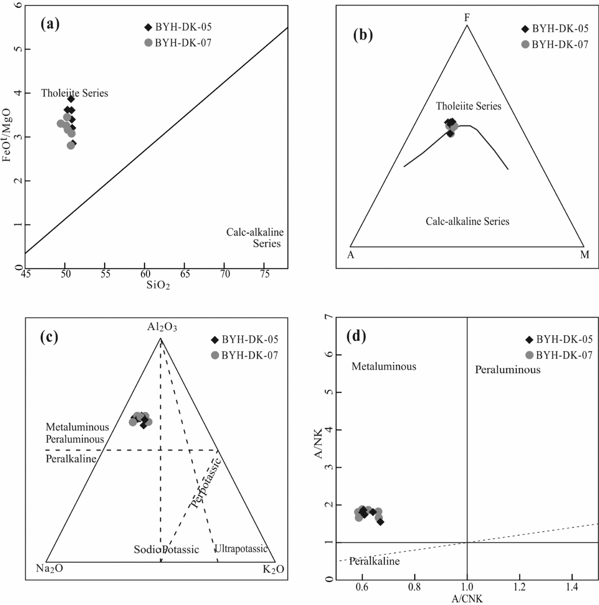
Samples of the Baiyanghe dolerites plot in the ‘trachy-basalt’ field, except for two samples, which plot in the ‘basaltic trachy-andesite’ field in the (K2O+Na2O) versus SiO2 diagram (Fig. 3), ‘tholeiite series’ field in the FeOt/MgO versus SiO2 diagram (Fig. 4a) and AFM diagram (Fig. 4b), and ‘metaluminous’ field in the molar Na2O–Al2O3–K2O diagram (Fig. 4c) and the A/NK versus A/CNK diagram (Fig. 4d), in which A/CNK ratios vary from 1.02 to 1.08. Based on the petrographical and geochemical characteristics, we can conclude that the Baiyanghe dolerites are metaluminous tholeiite basalts.
Total alkali (K2O+Na2O) versus silica (SiO2) diagram (Le Bas et al. Reference Le Bas, Le Maitre, Streckeiser and Zanettin1986).

(a) FeOt/MgO versus SiO2 diagram (Miyashiro, Reference Miyashiro1975); (b) AFM diagram for volcanic and hypabyssal intrusive rocks from the Vanson Peak quadrangle. A – Na2O+K2O; F – FeO+Fe2O3; M – MgO (Irvine & Baragar, Reference Irvine and Baragar1971); (c) molar Na2O–Al2O3–K2O diagram; (d) A/NK versus A/CNK diagram (Maniar & Piccoli, Reference Maniar and Piccoli1989).

4.b. Trace-element geochemistry
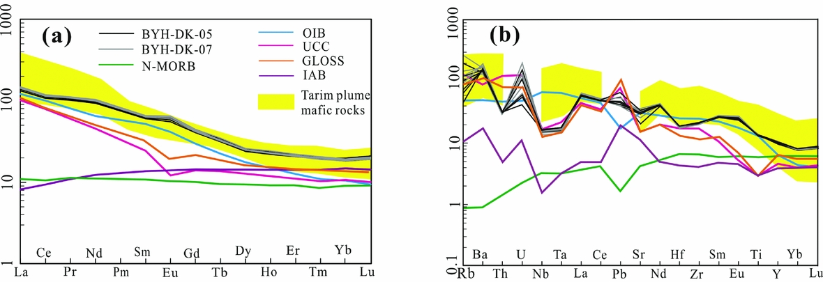
The trace-element concentrations of the Baiyanghe dolerites are shown in Table 1. The total REE contents of the dolerites, excluding Y, vary from 239.1 ppm to 265.4 ppm. Chondrite-normalized REE patterns for all samples are shown in Figure 5a. Most of these samples are enriched in light rare earth elements (LREE) (LREE = 208.81–232.42 ppm, LREE/HREE = 6.78–7.28, (La/Sm)N = 2.25–2.34, (La/Yb)N = 7.42–8.36), and display smooth to right-inclined REE distribution patterns. These samples also exhibit relatively high contents of heavy rare earth elements (HREE) with flat HREE patterns ((Dy/Yb)N = 1.02–1.09) and are coupled with no significant Eu anomalies and δEu values that vary from 1.12 to 1.20. This indicates that fractional crystallization of feldspar is weak during magmatic processes.
(a) Chondrite-normalized rare earth element patterns and (b) primitive-mantle-normalized multi-element diagrams for the mafic dykes. REE abundances for chondrites and trace-element abundances for primitive mantle are after Sun & McDonough (Reference Sun, McDonough, Saunders and Norry1989). Data for OIB, N-MORB, chondrite and primitive mantle from Sun & McDonough (Reference Sun, McDonough, Saunders and Norry1989); data for UCC from Wedepohl (Reference Wedepohl1995); data for GLOSS from Plank & Langmuir (Reference Plank and Langmuir1998); data for IAB from Ewart, Collerson & Regelous (Reference Ewart, Collerson and Regelous1998); data for Tarim plume-related mafic rocks from Zhang et al. (Reference Zhang, Li, Li, Xu, Zhou and Ye2010).

In the primitive mantle-normalized spider diagram (Fig. 5b), all samples exhibit clear enrichments of large ion lithophile elements (LILEs; e.g. Rb, Ba, Sr, Pb and U) and depletions in Nb and Ta without visible Ti depletions. The high contents of Sr (436 ppm to 787 ppm) and seemingly negative anomalies in the diagram are probably because of the relatively high contents of Pb and Nd. The trace-element distribution patterns are comparable with global subducting sediments (GLOSS) and upper continental crust (UCC). Compared with OIB, the differences are focused on the positive Ba and negative Nb–Ta anomalies in our samples (Fig. 5b). The negligible negative Zr–Hf anomalies are different from subduction-related island-arc basalts (IABs), and all trace-element contents of the samples are obviously more enriched than in IABs and normal mid-ocean ridge basalts (N-MORBs). These trace-element characteristics indicate that the magma source of the Baiyanghe dolerites is probably heterogeneous.
4.c. Zircon U–Pb ages
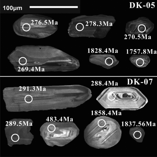
Zircons from the BYH-DK-05 and BYH-DK-07 dolerite samples are 20–150 μm in length, predominantly euhedral and prismatic, and they do not exhibit obvious concentric oscillatory zoning of magmatic origin (Fig. 6). Because the Th/U ratios of zircons from the dolerites vary from 0.29 to 1.56, except for two that are 0.05 and 0.06, these zircons are therefore believed to be magmatic in origin (Deng et al. Reference Deng, Wang, Yang, Liu, Zhang, Yang and Yang2010).
CL images of zircons from the Baiyanghe dolerites.

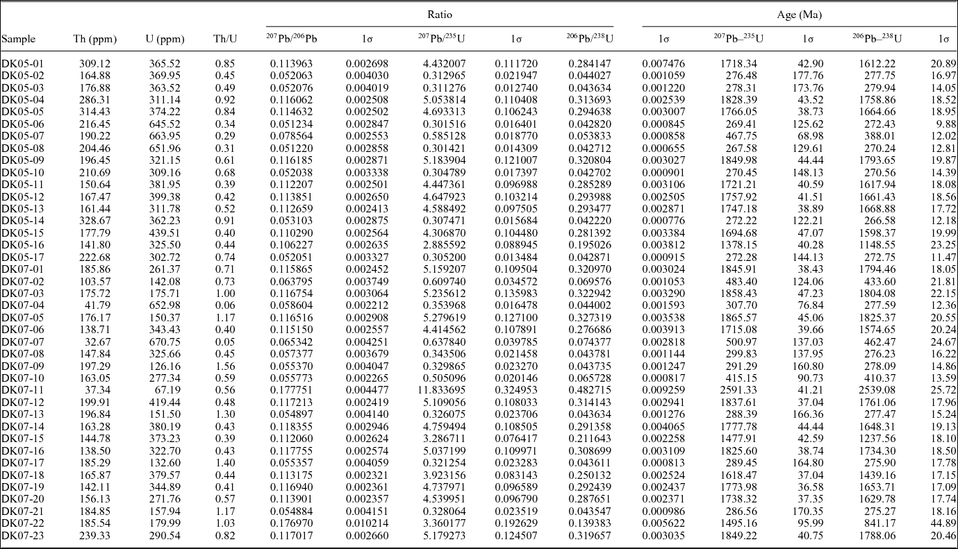
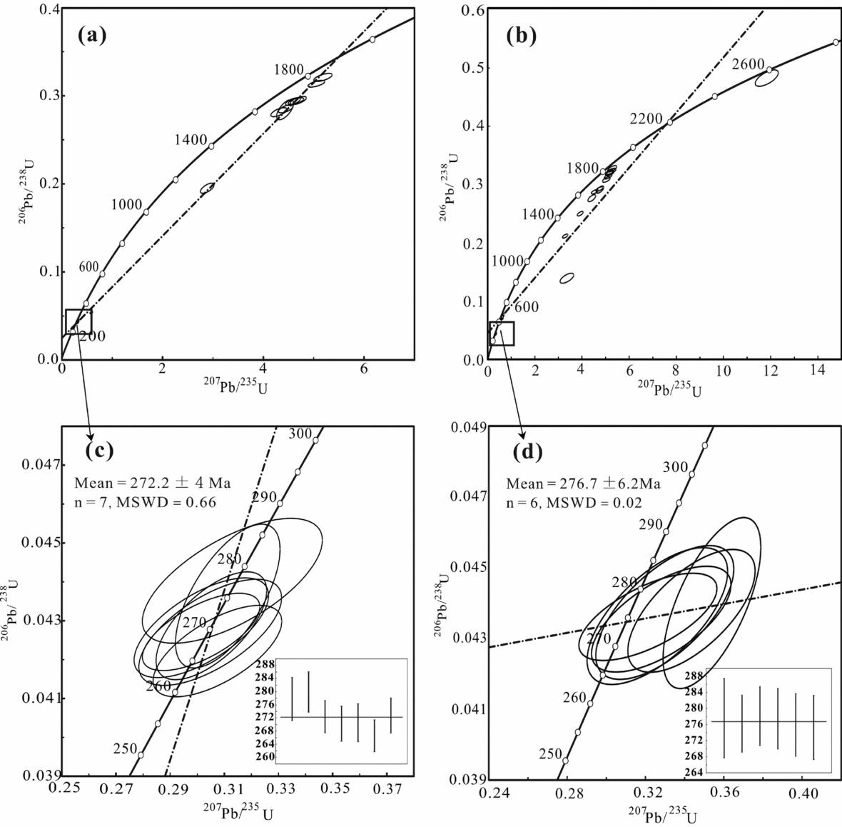
The U–Pb isotope analytical results for the 17 and 23 zircons from the BYH-DK-05 and BYH-DK-07 dolerite samples, respectively, are listed in Table 2. Of the 17 locations analysed for the BYH-DK-05 dolerite sample, 10 of these give Proterozoic ages (1148–1793 Ma) (Fig. 7a). The remaining seven locations yield a weighted mean 206Pb–238U age of 272.2±4 Ma (n = 7, MSWD = 0.66, probability = 0.69) (Fig. 7c). Of the 23 locations analysed for the BYH-DK-07 dolerite sample, 14 of these give Proterozoic to Archaean ages (841–2539 Ma) and 3 yield Early Palaeozoic ages (410–462 Ma) (Fig. 7b). The remaining six locations yield a weighted mean 206Pb–238U age of 276.7±6.2 Ma (n = 6, MSWD = 0.02, probability = 1) (Fig. 7d). Tectonically, northern West Junggar mainly involves the Zharma-Saur and Boshchekul-Chingiz volcanic arcs from north to south, and their Palaeozoic lithostratigraphy ranges in age from Ordovician to Permian (Fig. 1b). The NW-trending Boshchekul-Chingiz volcanic arc mainly consists of Middle Cambrian – Middle Silurian clastic rocks, volcanic rocks and pyroclastic sediments (Yakubchuk & Degtyarev, Reference Yakubchuk and Degtyarev1998). In particular, the volcanism in the arc occurred during Cambrian to Early Silurian times and diminished at the end of the Early Silurian period (Degtyarev, Reference Degtyarev1999; Levashova et al. Reference Levashova, Van der Voo, Abrajevitch and Bazhenov2009). This arc collided with the Stepnyak arc during Middle Ordovician time (Sengör, Natalin & Burtman, Reference Sengör, Natalin and Burtman1993). Thus, we speculate that the zircons with Ordovician to Silurian ages (410–462 Ma) may be xenocrysts that were captured from the wall rocks through which the dolerites passed. For the older zircons with Proterozoic to Archaean ages, they were possibly gravels or detrital zircons from a neighbouring provenance. For example, the U–Pb age data of detrital zircons from the Bayisi and Altungol, Tarim Craton, sedimentary samples define three major age groups (2800–2300 Ma, 2050–1800 Ma and 900–700 Ma; He et al. Reference He, Zhu, Ge, Zheng and Wu2014). The youngest weighted mean 206Pb–238U ages of 272.2±4 Ma and 276.7±6.2 Ma probably represent the emplacement ages of these two dolerite dykes.
The zircon U–Pb dating results of the BYH-DK-05 and BYH-DK-07 dolerites, determined by LA-ICP-MS

U–Pb concordia diagrams for zircons from the Baiyanghe dolerites.

4.d. Sr–Nd isotopic systems
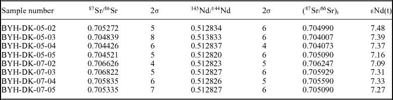
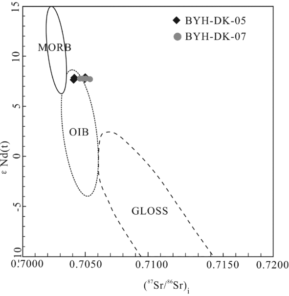
The Sr and Nd isotopic data and the Rb, Sr, Sm and Nd concentrations of the Baiyanghe dolerites are presented in Table 3. The initial 87Sr/86Sr ratios (0.70442 to 0.70682) are consistent with OIBs (0.7044–0.7065, White & Hofmann, Reference White and Hofmann1982; 0.7044–0.7051, Cliff, Baker & Mateer, Reference Cliff, Baker and Mateer1991; 0.7051, Saunders, Norry & Tarney, Reference Saunders, Norry and Tarney1988). Moreover, in the εNd(t) versus (87Sr/86Sr)i diagram, the samples plot in or on the border of the ‘OIB’ field (Fig. 8). The relatively constant εNd(t) values (+7.09 to +7.48) suggest that crustal contamination during emplacement is negligible.
Sr–Nd isotopic compositions of the BYH-DK-05 and BYH-DK-07 dolerites, determined by LA-MC-ICP-MS

Strontium and Nd isotopic ratios were measured using a MC-ICP-MS at the IGCAS.
Chondrite Uniform Reservoir (CHUR) values (87Sr/86Sr = 0.7045; 143Nd/144Nd = 0.512638; 147Sm/144Nd = 0.1967) were used for the Sr and Nd isotope calculation.
λRb = 1.42 × 10⁻¹¹ year−1; λSm = 6.54 × 10⁻¹² year−1.
ƒSm/Nd = (147Sm/144Nd)S / (147Sm/144Nd)CHUR−1.
εNd(0) = [(143Nd/144Nd)S / 0.512638−1] × 10000.
εNd(t) = εNd(0) − Q × ƒSm/Nd × t(Ga), Q = 25.1; t = 0.313 Ga.
Whole-rock Sr–Nd–Hf isotopes of Baiyanghe dolerites. εNd(t) versus (87Sr/86Sr)i diagram. MORB, OIB and GLOSS fields are shown (Hofmann, Reference Hofmann1997; Nowell et al. Reference Nowell, Kempton, Noble, Fitton, Saunders, Mahoney and Taylor1998; Chauvel et al. Reference Chauvel, Lewin, Carpentier, Arndt and Marini2008)

5. Discussion
5.a. Alteration effects
Before using the elemental and isotopic compositions to discuss the petrogenesis, we evaluated the possible effects of hydrothermal alteration. The samples from the Baiyanghe dolerites are variably altered; their LOI (weight loss on ignition at 1100°C) values range from 3.98 to 5.72 wt%. In most cases, the high-field-strength elements (HFSE), REEs, Th and transition elements are immobile during the most intense hydrothermal alteration (e.g. Hawkesworth et al. Reference Hawkesworth, Turner, McDermott, Peate and van Calsteren1997; Zhou, Reference Zhou1999). In addition, some major elements such as Ti and P are not readily transported by hydrothermal alteration (e.g. Zhou, Reference Zhou1999), but Ca, Na, K, Al and some of the LILEs (e.g. Sr, Ba and Rb) are considerably mobile (Smith & Smith, Reference Smith and Smith1976). Thus, these mobile elements will not be employed for petrogenetic interpretations in our work. Previous studies have also shown that only severe alteration by interaction with seawater can affect the 143Nd/144Nd ratios (Mahoney et al. Reference Mahoney, Frei, Tejada, Mo, Leat and Nagler1998), and the 143Nd/144Nd ratios of terrestrial igneous rocks remain nearly unmodified by extensive hydrothermal alteration (e.g. Menzies et al. Reference Menzies, Long, Ingeram, Talnfl, Janfcky, Pritchard, Alabaster, Harris and Neary1993).
5.b. Petrogenesis of the Baiyanghe dolerites
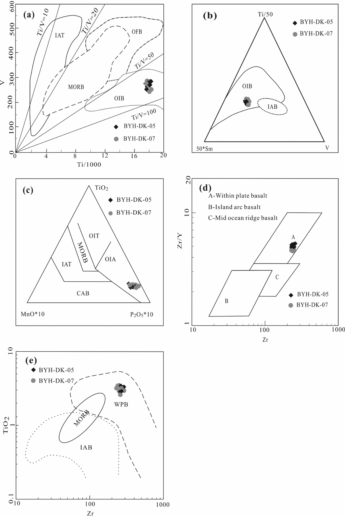
The chondrite-normalized REE and primitive mantle-normalized trace-element patterns are shown in Figure 5, and the average of OIB, N-MORB, UCC, GLOSS and IAB are shown for comparison. All samples display uniform chondrite-normalized REE patterns and are consistent with the OIB pattern, which indicates that all samples have the same enriched magmatic source. The (La/Sm)N ratio of our samples ranges from 2.25 to 2.34, which is consistent with OIB ((La/Sm)N = 2.39, Sun & McDonough, Reference Sun, McDonough, Saunders and Norry1989). The (La/Yb)N ratio (7.42–8.36) of our samples is less than that of OIB ((La/Yb)N = 12.29, Sun & McDonough, Reference Sun, McDonough, Saunders and Norry1989) but greater than that of GLOSS ((La/Yb)N = 7.48, Plank & Langmuir, Reference Plank and Langmuir1998), which implies that the initial magma of the dolerites might be a mixture of OIB-like and GLOSS-like melts. All samples are plotted in the ‘OIB’ field on the V–Ti/1000 (Fig. 9a) and 50*Zr–Ti/50–Sm discrimination diagrams (Fig. 9b). Similarly, our samples have high TiO2 and P2O5 contents, which makes them plot in the ‘ocean-island alkali basalt’ (OIA) array on the TiO2–MnO*10–P2O5*10 diagram (Fig. 9c). Furthermore, on account of the high Ti and Zr contents, our samples fall in the ‘within-plate basalts’ (WPB) field on the Zr/Y–Zr (Fig. 9d) and TiO2–Zr tectonic discrimination diagrams (Fig. 9e). In general, the geochemical characteristics of the Baiyanghe dolerites indicate that they are OIB-type rocks and were potentially formed from intra-plate magmatism involving sediments.
Tectonic discrimination diagrams for the alkaline basalts. (a) V versus Ti/1000 plot (Shervais, Reference Shervais1982). Fields of island-arc tholeiite (IAT), mid-ocean ridge basalt (MORB), ocean flood basalt (OFB) and ocean-island basalt (OIB) were drawn following Rollinson (Reference Rollinson1993). (b) Ti–Sm–V diagram (Vermeesch, Reference Vermeesch2006). (c) TiO2–MnO*10–P2O5*10 diagram (Mullen, Reference Mullen1983); CAB – calc-alkali basalt; IAT – island-arc tholeiite; MORB – mid-ocean ridge basalt; OIA – ocean-island alkali basalt; OIT – ocean-island tholeiite. (d) Zr/Y versus Zr diagram (Pearce & Norry, Reference Pearce and Norry1979). (e) TiO2 versus Zr diagram (after Pearce, Reference Pearce and Thorpe1982).

By accepting the notion that mantle compositional heterogeneity results from plate tectonics, it is logical to search for the incompatible element-enriched OIB component in this context. Hofmann & White (Reference Hofmann and White1982) were the first advocates of ‘recycled oceanic crust’ (ROC) as the enriched source material for OIB. There have been other discussions as to why OIBs are highly enriched geochemically, such as the enriched components being the products of lithospheric mantle that is recycled and metasomatized (McKenzie & O'Nions, Reference McKenzie and O'Nions1995; Niu & O'Hara, Reference Niu and O'Hara2003; Pilet et al. Reference Pilet, Hernandez, Sylvester and Poujol2005; Pilet, Baker & Stolper, Reference Pilet, Baker and Stolper2008), or that a small percentage of melts originate from the asthenosphere (Hirano et al. Reference Hirano, Takahashi, Yamamoto, Abe, Ingle, Kaneoka, Kimura, Hirata, Ishii, Ogawa, Machida and Suyehiro2006, Reference Hirano, Koppersw, Takahashi, Fujiwara and Nakanishi2008). Recent discoveries from mid-ocean ridge and subduction systems worldwide indicate that enriched basalts are not limited to hotspot or plume settings: they are actually widespread and can be found in oceanic spreading ridges (Rogers, Reference Rogers, Pritchard, Alabaster, Harris and Neary1993; Niu, Collerson & Batiza, Reference Niu, Collerson and Batiza1999; Niu et al. Reference Niu, Regelous, Wendt, Batiza and O'Hara2002; Hémond et al. Reference Hémond, Hofmann, Vlastélic and Nauret2006; Nauret et al. Reference Nauret, Abouchami, Galer, Hofmann, Hemond, Chauvel and Dyment2006) and in some arc-related settings (Bacon et al. Reference Bacon, Bruggman, Cheitiansen, Clynne, Donnelly-Nolan and Hildreth1997; Kita et al. Reference Kita, Yamamoto, Asakawa, Nakagawa, Taguchi and Hasegawa2001; Scott, Mueller & Pilote, Reference Scott, Mueller and Pilote2002). Some authors have suggested that subducted continental sediments may be responsible for enriched signatures of OIB in terms of both incompatible trace elements and isotopes (e.g. Chauvel, Hofmann & Vidal, Reference Chauvel, Hofmann and Vidal1992; White & Duncan, Reference White, Duncan, Basu and Hart1996; Hofmann, Reference Hofmann1997; Jackson et al. Reference Jackson, Hart, Koppers, Staudigel, Konter, Blusztajn, Kurz and Russell2007).
Recycled oceanic crust as a solidified mantle melt should have elevated abundances of incompatible elements. However, the ocean crust is depleted in progressively incompatible elements (e.g. (La/Sm)PM (Ocean Crust) < 1; Niu, Reference Niu2004) (the subscript ‘PM’ refers to the normalized ratio against the primitive mantle) and cannot readily explain the incompatible element-enriched nature of OIB ((La/Sm)PM (OIB) >> 1; Niu & O'Hara, Reference Niu and O'Hara2003). The (La/Sm)PM(samples) ratio of our samples is 2.25–2.34; thus, the ROC source can be ruled out. The geochemical attributes of our samples have no implications for arc-related signatures, as mentioned above. From the trace-element spider diagram, the negative Nb–Ta anomalies, negligible negative Zr–Hf anomalies and other elements of the samples are completely different from subduction-related IABs. Furthermore, all samples plot in the WPB field in Figure 9d, e; thus, it is unrealistic that the Baiyanghe dolerites are associated with a subduction tectonic setting. If the OIBs formed in oceanic spreading ridges, enriched basalts should also be found, such as E-MORB (Hémond et al. Reference Hémond, Hofmann, Vlastélic and Nauret2006; Nauret et al. Reference Nauret, Abouchami, Galer, Hofmann, Hemond, Chauvel and Dyment2006). However, recent studies demonstrate that the E-MORB rocks are very limited in this region Zhang et al. Reference Zhang, Xiao, Han, Mao, Ao, Guo and Ma(2011b). Niu & O'Hara (Reference Niu and O'Hara2003) and Niu et al. (Reference Niu, Wilson, Humphreys and Hara2012) argued that metasomatized mantle lithosphere provides the major source/component for OIB and produces high-magnesian melts for primitive OIB through local partial or total melting. Our samples have a relatively low Mg-number value (34–41) and are depleted in HFSEs (Nb, Ta, Ti, Zr, Hf), which is different from OIB-type rocks formed under this setting (Niu & O'Hara, Reference Niu and O'Hara2003). Therefore, such a case can be excluded.
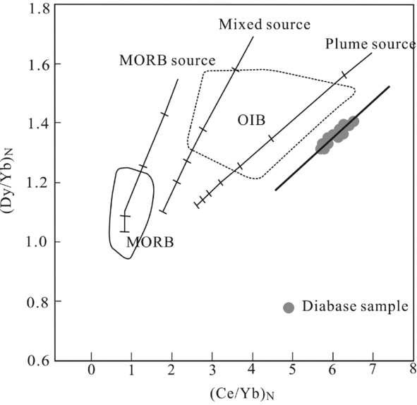
The West Junggar and northern Xinjiang regions experienced unusual tectono-thermal events during Palaeozoic time. The large number and areal extent of Late Carboniferous–Permian granitoids in West Junggar and its surrounding regions can only be explained by large-scale mantle heating during that period. The role of mantle activity in the region is confirmed by the presence of the Tarim Permian large igneous province (Yang et al. Reference Yang, Li, Chen, Santosh, Dong and Yu2007; Tian et al. Reference Tian, Campel, Allen, Guan, Pan, Chen, Yu and Zhu2010; Li et al. Reference Li, Li, Chen, Santosh, Yang, Xu, Langmuir, Chen, Yu and Zou2012) and the Tianshan Carboniferous large igneous province (Xia et al. Reference Xia, Xu, Xia, Li, Ma and Wang2003, Reference Xia, Xu, Xia, Li, Ma and Wang2004; Su et al. Reference Su, Qin, Sakyi, Li, Yang, Sun, Tang, Liu, Xiao and Malaviarachchi2011). Zhang et al. (Reference Zhang, Li, Li, Ye and Li2008, Reference Zhang, Li, Li, Xu, Zhou and Ye2010) studied the Permian basalts of the Tarim and western CAOB and proposed the occurrence of a Bachu large igneous province and a 275 Ma mantle plume event in northern Xinjiang. Additionally, a number of Late Carboniferous – Early Permian A-type granitoids with high positive εNd(t) values were formed in West Junggar and adjacent areas (e.g. North Tianshan, East Junggar, Altai and East Tianshan–Baishan) (Jahn, Wu & Chen, Reference Jahn, Wu and Chen2000a,b; Chen & Jahn, Reference Chen and Jahn2004; Wang et al. Reference Wang, Chen, Zhan, Shu, Faure, Cluzel, Charvet and Laurent-Charvet2007; Geng et al. Reference Geng, Sun, Yuan, Xiao, Xian, Zhao, Zhang, Wong and Wu2009; Chen et al. Reference Chen, Han, Ji, Zhang, Xu, He and Wang2010; Chen, Han & Zhang, Reference Chen, Han and Zhang2010). Furthermore, Carboniferous–Permian intermediate–mafic dyke swarms (Yin et al. Reference Yin, Yuan, Sun, Long, Zhao, Wong, Geng and Cai2010; Feng et al. Reference Feng, Li, Liu, Zhang and Qu2012; Zhang & Zou, Reference Zhang and Zou2013) are widespread in the Junggar and East Tianshan–Baishan areas, which supports the role of a mantle plume or superplume event (Stein & Hofmann, Reference Stein and Hofmann1994; Condie, Reference Condie1998; Pirajno et al. Reference Pirajno, Mao, Zhang, Zhang and Chai2008, Reference Pirajno, Ernst, Borisenko, Fedoseev and Naumov2009). In the (Dy/Yb)N versus (Ce/Yb)N source discrimination diagram (Fig. 10), the linear relationship of our samples is consistent with a ‘plume source’. The (La/Sm)N ratio of magma related to a mantle plume is less than 5 (Lassiter & DePaolo, Reference Lassiter, DePaolo, Mahoney and Coffin1997) and the La/Sm ratio of our samples is 3.49–3.61. All the above evidence indicates that our OIB-type rocks are much more likely the products of a deep OIB reservoir with a plume.
(Dy/Yb)N versus (Ce/Yb)N diagram (Haase & Devey, Reference Haase and Devey1996). MORB and OIB fields from Haase & Devey (Reference Haase and Devey1996).

5.c. Tectonic setting and petrogenetic model of the Baiyanghe dolerites
What type of plume is in northern West Junggar? There are dozens of inconsistencies in the definition of ‘plumes’ (Sleep, Reference Sleep1992; DePaolo et al. Reference DePaolo, Bryce, Dodson, Shuster and Kennedy2001; Hawkesworth & Schersten, Reference Hawkesworth and Schersten2007). Hofmann & White (Reference Hofmann and White1982) proposed ‘mantle plumes from ancient oceanic crust’, which explicitly means that the mantle source material for OIB is recycled oceanic crust, and we have excluded such a case, as mentioned above. Following this, Zorin et al. (Reference Zorin, Turutanov, Kozhevnikov, Rasskazov and Ivanov2006) argued that ascending convection flow from the mantle transition zone (MTZ) splits into separate streams, which are the upper mantle plumes. However, Ringwood (Reference Ringwood1991) envisaged that a break-up of descending slab piles over the discontinuity created a large ‘megalith’ composed of modified harzburgite. Many authors have suggested that subducted terrigenous sediments could be responsible for the incompatible element-enriched signature of some OIB.
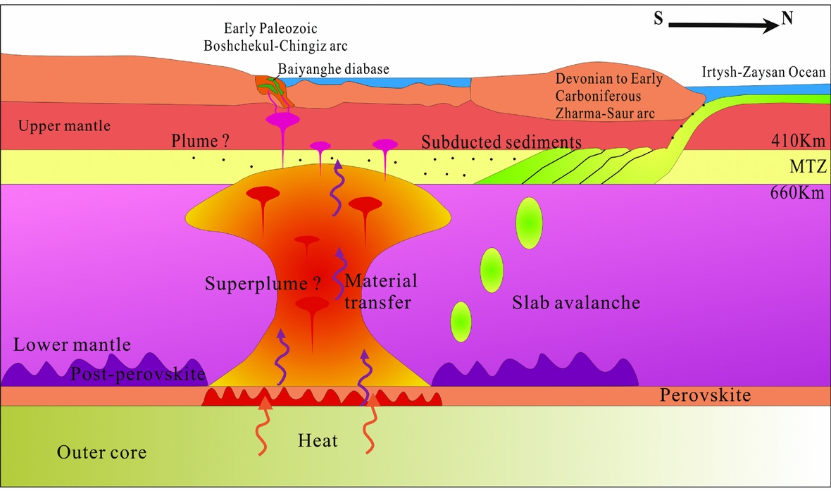
In the context of plate tectonics with mantle circulation, it is possible and likely that terrigenous sediments can be transported into the source regions of oceanic basalts. However, there is no convincing evidence for their significance as a major enriched component of the global OIB source, in terms of the familiar continental crust (CC)-like signatures (Niu et al. Reference Niu, Wilson, Humphreys and Hara2012). Thus far, the best evidence for OIB suites with an apparent ‘CC-like signature’ is from the Naturaliste oceanic plateau in the Indian Ocean (Mahoney et al. Reference Mahoney, Jones, Frey, Salters, Pyle and Davies1995), as well as some lava flows from Samoa (Savai) in the Southwest Pacific (Jackson et al. Reference Jackson, Hart, Koppers, Staudigel, Konter, Blusztajn, Kurz and Russell2007). From the REE patterns diagram (Fig. 5a), the similarity between all samples, average OIB, UCC and GLOSS is encouraging. The UCC and GLOSS are characterized by depletion in Nb and Ta and enrichment in Ba, U and Pb, which is consistent with our samples and indicates that subducted sediments might have been added into the magma source. In addition, the (La/Yb)N ratio of our samples (7.42–8.36) is less than OIB ((La/Yb)N = 12.29, Sun & McDonough, Reference Sun, McDonough, Saunders and Norry1989) but greater than the La/Yb(N) ratio of GLOSS ((La/Yb)N = 7.48, Plank & Langmuir, Reference Plank and Langmuir1998), which complies with the interpretation of sediment involvement. In a recently suggested scenario, the subducted crustal material may have accumulated at the MTZ (Maruyama et al. Reference Maruyama, Omori, Sensu, Kawai and Windley2011; Safonova & Maruyama, Reference Safonova and Maruyama2014) and then formed an upwelling mantle plume to produce OIB magma (Safonova, Litasov & Maruyama, Reference Safonova, Litasov and Maruyama2015). The deep mantle processes at the MTZ (between depths of 410 and 660 km) and the core–mantle boundary (CMB, depth of 2700 km), which could be linked to the supply/presence of water in the mantle, would result in subduction and accumulation of crustal material in the MTZ (Maruyama, Reference Maruyama1994; Clift & Vannucchi, Reference Clift and Vannucchi2004; Ohtani et al. Reference Ohtani, Litasov, Hosoya, Kubo and Kondo2004; Maruyama, Santosh & Zhao, Reference Maruyama, Santosh and Zhao2007; Kawai et al. Reference Kawai, Tsuchiya, Tsuchiya and Maruyama2009; Yamamoto et al. Reference Yamamoto, Senshu, Rino, Omori and Maruyama2009; Litasov, Reference Litasov2011; Maruyama et al. Reference Maruyama, Sawaki, Ebisuzaki, Ikoma, Omori and Komabayashi2014; Safonova & Maruyama, Reference Safonova and Maruyama2014). The heat generated by the subducted continental crust material is enough to increase the temperature of the ambient mantle (Senshu et al. Reference Senshu, Maruyama, Rino and Santosh2009). Therefore, the accumulation of continental crust material and the heating in the MTZ could induce mantle upwelling and generate volatile-bearing plumes, which may reach the lithosphere. The melts generated in the MTZ could separate and ascend to form a cluster of smaller plumes, which could then merge to form a larger plume. These volatile-bearing plumes may be the source of OIB-type basalts (Safonova, Litasov & Maruyama, Reference Safonova, Litasov and Maruyama2015).
The Baiyanghe porphyry (Zhang et al. Reference Zhang, Zou, Yao and Dong2014) and dolerites are located behind the Zharma-Saur arc. The porphyry and its controlling fault show a nearly E–W trend, which is compatible with the N–S extensional environment of the back-arc basin. Thus, such a setting would be the southward subduction of the Irtysh-Zaysan oceanic lithosphere beneath the Zharma-Saur arc in the northern part of West Junggar. The Late Silurian – Early Devonian plutons mainly occur in the Boshchekul-Chingiz volcanic arc (Chen et al. Reference Chen, Han, Ji, Zhang, Xu, He and Wang2010), and there are some Early Carboniferous granites, which are OIB-type rock intrusions. The Irtysh-Zaysan oceanic lithosphere is potentially accompanied by sediments subducted to the Zharma-Saur arc and sediments accumulated at the MTZ. The heat generated by the subducted sediments may have been enough to increase the temperature of the ambient mantle to induce mantle melting, and the melts generated in the MTZ thus formed a plume. The magma derived from the plume then upwelled to form the OIB-type dolerites (Fig. 11). The Tarim flood basalts formed (288.9±2.0 Ma) as a result of mantle plume-derived melts mixing with SCLM-derived melts, which have low MgO (4.3–5.9 wt%) and high TiO2 (3.8–5.1 wt%) contents. They show fractionated LREE and nearly flat HREE patterns with noticeable negative Nb and Ta anomalies (Xu et al. Reference Xu, Wei, Luo, Liu and Cao2014). Zhang et al. (Reference Zhang, Li, Li, Xu, Zhou and Ye2010) reported that the Piqiang dolerites, Permian basalts and Bachu mafic dykes emplaced at c. 275 Ma within the interior of the Tarim Block, as well as the voluminous basalts in the Tarim, Junggar, Santanghu and Tuha basins, were spatially and temporally related to the intrusive rocks that were the likely products of the Tarim mantle plume. We compared these mafic rocks that are related to the Tarim mantle plume with our samples. All the mafic rocks are in accordance with OIB and our samples, as shown in Figure 5a. Furthermore, most samples exhibit clear Rb and Ba enrichments and depletions in Nb and Ta without visible Ti depletions in Figure 5b. The (La/Sm)N ratios (2.3–4.4, 2.3–2.7) of the Bachu mafic dykes and Permian basalts are similar to our samples (2.25–2.34). All of the above geochemical characteristics are in accordance with our samples. Thus, we speculate that the plume source of the Baiyanghe dolerites may be a branch of the Tarim mantle plume.
Superplume rising from the core–mantle boundary fuelled by ‘slab graveyards’ and the formation mechanism of the plume beneath the Baiyanghe area after Maruyama et al. (Reference Maruyama, Hasegawa, Santosh, Kogiso, Omori, Nakamura, Kawai and Zhao2009) and Zhou et al. (Reference Zhou, Yuan, Fan, Zhang, Cooke and Zhao2008).

5.d. Tectonic implications for West Junggar
Previous studies proposed different model types to account for the Late Carboniferous – Early Permian high-temperature magmatism. One view holds that the Phanerozoic CAOB alkaline granitoids were generated in a post-collisional setting (Chen & Arakawa, Reference Chen and Arakawa2005; Han et al. Reference Han, Ji, Song, Chen and Zhang2006; Zhou et al. Reference Zhou, Yuan, Fan, Zhang, Cooke and Zhao2008; Chen et al. Reference Chen, Han, Ji, Zhang, Xu, He and Wang2010), and many studies strongly support a ridge subduction regime in West Junggar during Late Carboniferous – Early Permian times (Geng et al. Reference Geng, Sun, Yuan, Xiao, Xian, Zhao, Zhang, Wong and Wu2009; Tang et al. Reference Tang, Wang, Wyman, Li, Zhao, Jia and Jiang2010, Reference Tang, Wang, Wyman, Li, Zhao and Yang2012a,b; Zhang et al. Reference Zhang, Xiao, Han, Ao, Yuan, Sun, Geng, Zhao, Guo and Ma2011a,b; Ma et al. Reference Ma, Xiao, Windley, Zhao, Han, Zhang, Luo and Li2012; Yang et al. Reference Yang, Li, Gu, Tong and Zhang2012a). Yang et al. (Reference Yang, Li, Xiao and Tong2015) proposed that the OIB-type rocks in the ophiolitic mélanges are considered accreted seamount fragments in the West Junggar accretionary complex, and these may represent the MTZ plume-related magmatism within the Palaeo-Asian Ocean. There was also a model proposed in which the Phanerozoic CAOB granitoids could be related to a mantle plume (Gao et al. Reference Gao, Xiao, Pirajno, Wang, He, Yang and Yan2014).
Yang et al. (Reference Yang, Li, Xiao and Tong2015) proposed that the MTZ plume may be the source of the OIBs in West Junggar. Zhang & Zhang (Reference Zhang and Zhang2014) first reported alkali-feldspar A1-type granite in West Junggar with OIB-like geochemical features, and Gao et al. (Reference Gao, Xiao, Pirajno, Wang, He, Yang and Yan2014) suggested that Phanerozoic CAOB granitoids could be related to a mantle plume. Thus, a series of evidence indicates that a mantle plume existed beneath the Baiyanghe area during Late Carboniferous – Early Permian times.
In a previous study, Safonova (Reference Safonova2009) suggested that the intra-plate magmatism (OIB, OIB-type basalts) in the CAOB occurred during two major periods, the Late Neoproterozoic – Early Palaeozoic and the Late Palaeozoic–Mesozoic, with a Middle Palaeozoic hiatus of c. 100 Ma. However, Safonova & Santosh (Reference Safonova and Santosh2014) summarized the Middle Palaeozoic OIB-bearing units in the CAOB, showing that the number of Middle Palaeozoic OIB-bearing units that have been identified so far is obviously less than that of the Late Neoproterozoic – Early Palaeozoic. It seems that the plume-related activity of the Palaeo-Asian Ocean was generally continuous, but its scale/intensity was smaller during the Middle Palaeozoic period.
Recently, Yang et al. (Reference Yang, Li, Xiao and Tong2015) summarized the lithological and geochronological information on the ophiolitic mélanges with OIB affinities occurring from south to north in West Junggar, including the Mayile, Tangbale, Karamay and Darbut ophiolites. They considered that these OIB-type rocks are accreted seamount fragments, which may represent the MTZ plume-related magmatism within the Palaeo-Asian Ocean. Seamounts are only the remains of the ancient mantle plume. By contrast, our samples are the youngest and direct evidence for the existence of the mantle plume; therefore, we can better constrain the position and time of existence of the mantle plume.
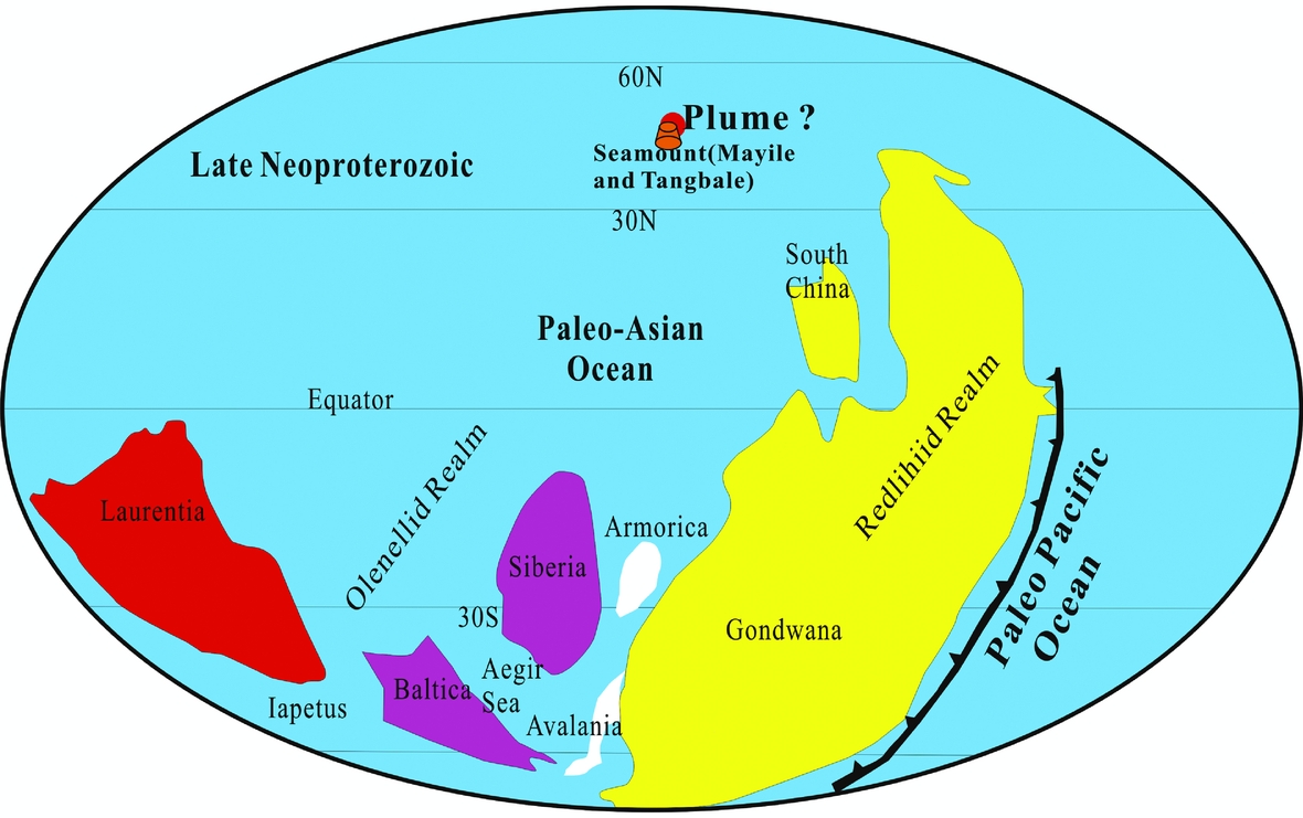
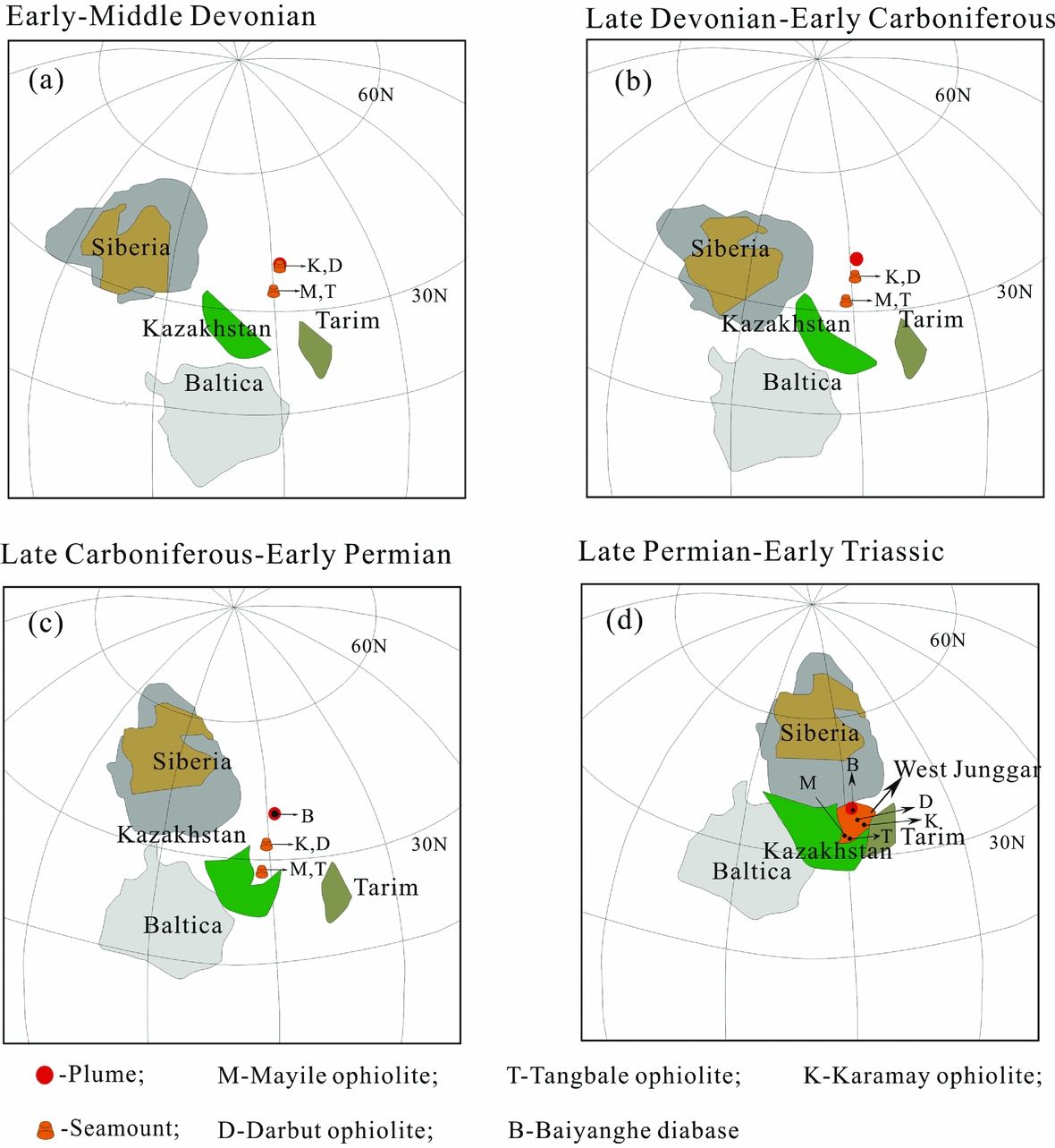
A zircon U–Pb age of 572±9 Ma for the Mayile ophiolitic mélanges has been reported by Yang et al. (Reference Yang, Li, Santosh, Gu, Yang, Zhang, Wang, Zhong and Tong2012b), and a layered gabbro from the Tangbale mélange was dated as 531±15 Ma by Jian et al. (Reference Jian, Liu, Shi, Zhang and Sklyarov2005). This evidence indicates that there was a mantle plume within the Palaeo-Asian Ocean during Late Neoproterozoic time (Fig. 12). Zircon U–Pb analyses from the alkaline basalt in the Karamay mélange yielded a weighted mean age of 395±3 Ma Yang et al. Reference Yang, Li, Yan, Tong, Han and Wang(2014b), and the gabbros from the Darbut mélange had a zircon U–Pb age of 391±7 Ma (Gu et al. Reference Gu, Li, Zhang, Tong and Wang2009). In this paper, the zircon U–Pb ages of dolerite dykes are 272.2±4 Ma and 276.7±6.2 Ma. Yang et al. (Reference Yang, Li, Xiao and Tong2015) argued that the multiple intra-oceanic subduction with seamount accretion model can better explain the tectonic evolution of the CAOB. Under the hypothesis that the location of the plume is settled and considering that the age of the OIB occurring from south to north in West Junggar becomes younger, we speculate that the movement direction of the oceanic crust was southwestward (from Baiyanghe to Mayile) during Middle Devonian – Early Permian times (Fig. 13).
Late Neoproterozoic palaeogeographic reconstruction and seamount in the Palaeo-Asian Ocean. Modified after Meert & Lieberman (Reference Meert and Lieberman2008).

Palaeogeographic reconstruction for the bending of the Kazakhstan oroclines with seamount subduction. The solid line denotes the Devonian Volcanic Belt above the pre-Late Permian subduction zone of the Junggar–Balkhash ocean basin. Modified after Abrajevitch et al. (Reference Abrajevitch, Van der Voo, Bazhenov, Levashova and McCausland2008) and Xiao & Santosh (Reference Xiao and Santosh2014).

6. Conclusions
(1) The zircon U–Pb age indicates that the Baiyanghe dolerite dykes were intruded at 272.2±4 Ma and 276.7±6.2 Ma.
(2) The geochemical and isotopic characteristics indicate that our samples are OIB-type rocks and the Baiyanghe dolerites were probably derived from a heterogeneous magma source that was composed of OIB-like and subducted sediment melts.
(3) There was probably a plume that existed beneath the Baiyanghe area during Early Permian time.
Acknowledgements
The study is supported by the Foundation of Basic Scientific Research (No. 862635), Scientific Research Unit, Lanzhou University (223000).