

Smuggling as a concept is deeply entrenched within contemporary scholarship. The term is defined as trade activity that is illicit or unsanctioned by government. It is therefore used to describe a wide range of activities, from evading taxes or duties to using covert means to move goods across borders. Colloquially, the term often denotes deliberately criminal activity, such as drug or arms smuggling. It is this very association, however, that tends to colour the way that scholarship has described smuggling in nineteenth-century India, as activities designed to undermine colonial authority or subvert British rule.
Over the last decade, an increasing amount of scholarship has emerged to directly consider the opium trade in western India, especially as it arose as a chiefly Indian enterprise, in contrast to the British-managed Bengal trade in the East. Amar Farooqui in particular has published several books and articles on the opium trade, but he has been joined by others such as John F. Richards and Claude Markovits who have considered the contribution of opium to the finances of British India, as well as the impact that the trade had on the political economy of the western region.Footnote 1 While smuggling certainly held a place in this conversation—with Farooqui and Markovits addressing it the most directly—it was largely mentioned only as a part of a larger discussion of the opium trade and, in most cases, as a precursor to the regulated Bombay trade of the nineteenth century. Those who chose to examine smuggling more directly have accordingly represented it as a subversive enterprise. Farooqui proposes that the eighteenth-century Malwa opium trade was fundamentally destabilising as it undermined the East India Company's monopoly. He subsequently emphasises the often-confrontational relationship between Indian capital and colonial authority as Malwa opium assumed a place of prominence within the western Indian economy. This interpretation underlines the transformative qualities of the opium trade for the political economy of western India. However, while in certain sectors this might certainly have been the case—namely in relation to mainstream enterprise—it is an approach that neglects the impact of smaller, local business activities on the region.Footnote 2 Moreover, the argument that Malwa opium was inherently subversive applies less well to the latter decades of the nineteenth century, after the trade was absorbed into the colonial revenue structure. This critique was addressed somewhat in Claude Markovits's 2009 article on the political economy of opium smuggling, in which he considers opium smuggling to be more the result of opportunism and ‘residual leakage’ than a systematic effort to undermine the colonial regime.Footnote 3 While useful in that it raises questions that problematise traditional smuggling narratives, it remains focused on opium as the commodity in question. By incorporating the traffic in other commodities into this story, this article offers insight into systematic continuities that played a role in the persistence of certain forms of supposedly illicit trade into the British period.
The following discussion thus seeks to bridge these existing gaps in two main ways. First, it will develop Farooqui's argument and, ultimately, suggest that though this had relevance during the earlier period, by the nineteenth century the character of the Malwa opium trade had changed to such an extent that his line of reasoning no longer holds true. This article therefore will dissect the relationship between Indian enterprise and colonial policy during the years between 1818 and 1870. Second, it will differentiate the ‘legitimate’ enterprise largely found in Bombay from the illicit trade conducted elsewhere in the region, while also highlighting the ambiguities present in making such distinctions. Ultimately, it is these very ambiguities that provide a place from which to appraise the nature of western India's illicit trade. The roots of such activity in the pre-colonial period, coupled with case studies from a number of Gujarati smuggling cases in the 1840s and 1850s, provide a basis for assessing the parameters that determined an enterprise's legality or illegality, and elucidating the wider impact of illegal trading activities and what they meant for the state of colonial administration in the region.
Smuggling in nineteenth-century India was not simply a subversive practice that grew in response to colonialism, but rather formed part of a longer-standing tradition of Indian trade. Smugglers as well as legitimate Indian traders were able to operate successfully under an intrusive colonial regime due to the solid foundation developed over centuries of participation in overseas trade. While the opium trade and the expansion of the Chinese market heralded an explosion of wealth and opportunity, the big Bombay firms, as well as small-scale merchant companies, were not developing business practices from scratch, but rather were adapting and building upon existing systems. The new opportunities that emerged over the course of the nineteenth century inspired a redirection of pre-existing systems. The adaptation, diversification and reorientation that occurred during this period were themselves part of a deeply-entrenched methodology for survival and success in the global marketplace. Furthermore, the employment by colonial officials of the term ‘smuggling’ to denote such activity is in itself significant, as it is suggestive of the attitudes that existed with regard to independent Indian enterprise. Perceptions of the risk posed by smugglers to the income of the British Raj played a discernible role in the construction of colonial administrative structures in the region, as well as helping to shape political alliances and territorial annexations within the realm of the Bombay Presidency.
Pre-Colonial Networks
It is impossible to exclude opium from any conversation about smuggling in India; opium was, without question, the country's single most profitable commodity of the nineteenth century. The sheer volume of opium being produced and the amount of money at stake made it simultaneously easy and attractive for smugglers to acquire, as well as a highly-regulated product facing extreme government scrutiny. However, smuggling methods were not used solely for opium. They were also used to convey other commodities, such as salt, timber and sugar. Salt, in particular, became a point of considerable tension between Gujarati manufacturers and the British authorities.Footnote 4
Though the period under scrutiny here was dominated by the rise of Bombay, in earlier years trade had been distributed amongst a number of ports along the coast. Karachi in the north, as well as Surat, Cambay and Broach in Gujarat, and Dabhol further south all played host to high volumes of exports. Particularly during the sixteenth and seventeenth centuries overseas trade was largely directed toward the Red Sea and Indian Ocean spheres, with some traders travelling further abroad to Zanzibar and other locations in east Africa.Footnote 5 The coasting trade—which travelled from port to port along India's vast seaboard—was also highly lucrative during this period and was generally considered the most expedient means of conveying goods from western India to Bengal and the Coromandel Coast. Goods sent eastwards in this manner were either consumed domestically or, as was often the case, re-exported to markets further afield in Southeast Asia.
Catering to such a large number of active seaports required an intricate system of overland supply routes. These were typically dominated by communities with a long history of commerce in their vicinity. For example, opium was chiefly grown in the central provinces, though fields also existed in the north, in Punjab and the Rajput States. Bohras from Gujarat dominated much of this trade. Particularly in the Rajput states, it was often easier for resident groups operating with the support of the local ruler to acquire rights to purchase and transport goods. They would thus obtain opium and transport it to a regional bazaar. Ujjain was one of the main commercial centres from which the Bohras operated, so from this point they would procure the drug and transport it to Burnhanpur for distribution to the coast. Alternatively, it was sometimes shipped directly from Malwa to Burnhanpur.Footnote 6 Hyderabad in Sind, as well as Jodhpur and Jaisalmer, were major points of convergence for overland opium dealers, who often carried the drug across borders on camelback. These routes, and this technique of transporting the drug through desert regions using camels, remained in use throughout the colonial period.
Trade in other products followed similar routes or travelled along waterways. Salt, for example, was a major commodity in Gujarat. The Maratha Peshwa and his local subordinates, such as the Gaekwars, constructed commercial salt works along the banks of the Mahi and Tapti river estuaries. The Nawab of Cambay similarly controlled salt works around the Gulf of Cambay. Products from these works were sent to Surat and Cambay for overseas shipment, or to Burnhampur for domestic distribution. Regionally, salt was also often moved by caravans of carts, though this was more dangerous as certain roads were impassable or were frequented by robbers. Regional salt traders, however, found safer routes for moving salt, avoiding popular roadways in favour of short hops from village to village through wooded areas. These routes, which overcame the need to travel on long stretches of exposed road, remained in common use among citizens of this region into the nineteenth century, while European and Bombay merchants typically used main roads and later, the railways.
The Portuguese also maintained a foothold in western India through much of the sixteenth and seventeenth centuries. Even after their strength in the region began to decline, they still remained influential and, in due course, their trading activities would help to construct the framework for smuggling under the British. The Portuguese relied heavily on the Gujarati merchant population, capitalising on the position held by these traders within the Red Sea and Indian Ocean Trades.Footnote 7 Gujaratis were also able to leverage their community ties for both their own advantage and that of their European partners. Hindu Bania networks were particularly strong; by the 1700s, members of this community had established a thriving base in Gujarat's main seaports, while their associates operated from ports all over the Persian Gulf and Red Sea regions. Through the employment of Bania agents the Portuguese were able to gain access to a greater number of markets, including those such as Aden—which at the time was administered by Ottoman Turkey—where they themselves would not have been welcomed. Meanwhile, Portuguese financing supported Bania enterprise and enabled them to continue to expand business for their own interests.Footnote 8
This relationship is indicative of the general processes of cooperation and adaptation practiced by the western Indian business classes. Many firms were short-lived, surviving through only one or two generations, and eventually folding under the pressures of changing circumstances. Those that survived often did so thanks to an ability to develop mutually beneficial links with foreign traders and overseas markets,Footnote 9 a tactic that had been practiced for centuries to maintain commercial links with wider Asian markets and Persian traders. Members of migrant groups, such as the Parsis and later Baghdadi Jews, also maintained close relationships with those in their homeland with whom they fostered commercial ties. The example of the Portuguese demonstrates how this practice was applied to European Companies and is notable in that the adaptations developed at this time remained in use after the arrival of the British. Moreover, this earlier relationship with the Portuguese was integral to the establishment of the physical foundations for the eighteenth-and-nineteenth-century illicit traffic in China Market goods. In the sixteenth century, the trade most valued by the Portuguese was that conducted along India's western coast, between Goa and the main ports of Gujarat, especially Cambay, but with stops along the way at Chaul, Bassein, Damaun and Surat. At this time the value of the trade with Gujarat surpassed even that with Portugal itself, being valued at well in excess of 4,000,000 Rupees per year.Footnote 10 Indian merchants facilitated Portuguese trade with Gujarat, maintaining a presence in the region's key ports and providing access to local commodities, such as salt, cotton, home manufactured textiles, and timber.
As the physical Portuguese presence in India diminished, ultimately replaced in many respects by the English East India Company, the mercantile communities with which they traded continued their operations relatively unabated. Despite widespread, ingrained inequality and racism within the European colonial structure, Indian merchants—particularly those from Gujarat—held a central position within the mercantile framework. The Portuguese trade is indicative of the general condition of seaborne commerce at the time that the British cemented their power in western India with a military victory over the Marathas in 1818.
To understand the dynamics of nineteenth-century smuggling in western India, it is important to consider this earlier phase, as it set a key precedent with respect to the evolution of mercantile communities over the course of the colonial period. The established reputation of Gujaratis as the dominant commercial group in the region survived the ebbing of local Portuguese power. Indeed, the relationship between Gujarati merchants and the Portuguese continued long after the British began enforcing their own monopolies, with Portuguese ports playing a crucial role in the circumvention of British authority and acting as key gateways for independent Indian exports. Furthermore, the history of building cooperative partnerships with colonising or foreign powers in order to facilitate trade, together with the persistence of pre-European commercial hierarchies, greatly influenced the volume of smuggling under British colonialism.
Dividing Communities
In due course, the intervention of European powers served to divide western India's mercantile community into two main groups: those who operated within the framework of British India and those who kept their activities largely separate, although the latter group included those who worked instead within the parameters established by various local princely states. These merchants often became the focal point of policy disagreements between these princely states and the Bombay Presidency; since they operated principally in accordance with the laws of their own state, if an area or policy was under dispute they could end up simultaneously violating colonial law.
The character of mercantile enterprise also varied significantly between so-called ‘legitimate’ traders and independent merchants.Footnote 11 Most obvious were locational differences; those who operated within the boundaries of British colonial law conducted business chiefly out of British ports, particularly Bombay, whereas independent traders used ports maintained by one of the princely states or the Portuguese. Legitimate traders also used mainly monitored modes of transportation, such as the railway network, which stopped at colonial observation points such as Bombay, Ahmedabad and Indore.
The most unique aspects of legitimate overseas trade, when compared with unsanctioned businesses, were the ways in which such firms were constructed and how they developed relationships. Most notable within the regulated trade were the Bombay-based firms, which established diversified portfolios and shareholder groups, allowing their owners to accumulate massive personal wealth. They developed cooperative relationships not only with each other but also with European firms. The Parsi firm, Sir Jamsetjee Jeejeebhoy Sons & Co., for example, had a long-standing partnership with the British company Jardine Matheson & Co. Jejeebhoy Sons acquired goods that were then licensed to their European partners for sale in China and throughout Southeast Asia.Footnote 12 Such arrangements were beneficial to both parties; in this case, the Jeejeebhoy-Jardine Matheson partnership provided the Parsi firm with access to broader sales channels in East Asia, while its British partners received superior supply avenues in the subcontinent. Such relationships, and the ability to capitalise on the widening, increasingly globalised economic sphere of the British Empire, were notable benefits of operating within the purview of colonial law.
Meanwhile, those trading outside the colonial sphere operated in a very different world. Such merchants often sold goods on a much smaller scale, either as independent businessmen or as localised family firms. Furthermore, since merchants were required to pay port duties to the government of that area in which they operated, many small-scale traders opted instead to ship goods from small inlets, avoiding the regulations and duties associated with official ports. Alternatively, they would ship goods down the coast to the Portuguese ports of Damaun and Diu, where they paid only minimal export duties and escaped entirely the watchful eye of the British East India Company. There are particularly frequent accounts of this practice being pursued by traders from Kutch, who evaded tariffs and export restrictions by utilising the port of Damaun to export products to China.Footnote 13
However, despite operating in fairly separate spheres, legitimate and illicit modes of mercantile enterprise were inextricably linked, held together through financial bonds and a shared history. Like their corporate counterparts, independent traders diversified their businesses, selling a variety of different goods. Although opium became a point of particular focus, given the lucrative nature of the trade, it was not the only product moved by these groups. Typically, those engaged in opium smuggling also evaded restrictions on the transport of commodities such as cotton, indigo and salt.Footnote 14 Moreover, their business also included shipment of legal commodities such as silk textiles, chintzes, and various other piece goods. In both cases, firms were built on foundations of kinship and developed from long-standing regional and overseas ties.Footnote 15 While those in Bombay often transcended the boundaries of traditional kinship groups to develop intercommunal links necessitated by the expanding scope of their investments, they were often—at least originally—outgrowths of pre-colonial businesses. Such firms did expand eventually into other sectors and through their ties with other Indian and European communities built large-scale, diversified, companies, but many began with a foundation in traditional community professions such as middlemen and moneylenders.Footnote 16 For instance, some of the earliest Parsi migrants to Bombay, such as the Rustomji family from Surat, began as agents to the European Companies in Gujarat before seeking greater success in Bombay.Footnote 17
This habit of crossing communal lines, though a clear departure from older business models, was not entirely restricted to Bombay firms. Just as ‘legitimate’ traders in Bombay adapted their practices to the needs of larger-scale foreign trade, so too did independent traders in other parts of western India.Footnote 18 In Gujarat, for example, it was primarily Muslim firms that owned ships and dominated the majority of overseas shipping. Konkan Muslims in particular gained a reputation as the foremost Indian Ocean traders in the sixteenth and seventeenth centuries, even managing to maintain this position of superiority after the arrival of the Portuguese.Footnote 19 Other groups engaged in overseas trade by leasing space for their goods on Muslim ships. Through such arrangements, these firms were able to sell considerable quantities of goods overseas without needing to travel or own ships. The emergence of such practices before Europeans arrived in India suggests that the talent for adaptation exhibited by groups such as the Parsis in Bombay was not a result of European intervention, but rather one that emerged organically within the region. Moreover, such continuities both within the Bombay Presidency and in the princely states further complicate the lines devised as a means of differentiating between ‘legitimate’ and ‘illegitimate’ trade.
Small-Scale Smuggling
Activity identified as smuggling was exceptionally prevalent in Gujarat over the course of the nineteenth century. The illicit trade was brought to the forefront of the colonial imagination following the 1818 Maratha defeat, as a result of increased market regulation associated with the consolidation of British authority in Bombay. At this time, the British leveraged their newly enhanced political foothold in the region to exert greater influence over the flow of goods into and around Bombay. Regulated goods were consistently transported without approval across the new boundaries between colonial territories and princely states. Although smuggling practices varied in scale and character, most significant in this particular region were localised activities. Small-scale smuggling was widespread and became virtually endemic to the regional economy; even if individual incidents were chiefly minor, together they posed a significant threat to Government profits.
The environmental landscape of Gujarat was, in large part, responsible for fostering the region's successful smuggling culture. Roads were particularly dangerous; many were not even equipped for carts, rendering them unfit for commercial use. They were also frequented by bands of thieves who would, often violently, divest travellers of their valuables.Footnote 20 The British addressed this problem in part through the construction of railway networks that not only bypassed roads and crossed state boundaries without requiring payment of the myriad transit duties. Instead, the railways connected British-held cities such as Bombay and Ahmedabad where cargoes could be closely monitored and administrative charges attached. Yet, it was this very outlay and heavy regulation that often deterred traders. Furthermore, routing goods through British-controlled cities often meant having to ship via long, out-of-the-way routes and incurring significant unnecessary expense for those conducting business on a smaller scale, or within a limited region, railways were impractical.
Moreover, Gujarat had a deeply entrenched commercial economy that long preceded the imposition of colonialism and the trade regulations that accompanied it. This was a culture of commerce; intricate networks of supply, production and sales preceded the arrival of European Companies, as did the tradition of adaptation, which in the nineteenth century allowed so many of these structures to persist. The western Indian economy had evolved over the centuries in a climate of constantly shifting political conditions and with input from foreign settlers and merchants. While the political landscape of the region had been repeatedly remodeled by outside influences—the Portuguese, Marathas and Mughals were a few notable entities who impacted the region over the centuries preceding the arrival of the British—the commercial culture remained, affected but not diminished by such political machinations. Largely, the ability of Gujarat's commercial economy to withstand political pressures was the result of business conducted on a local level. In the nineteenth century, though large-scale mercantile enterprise was substantially transformed to suit the conditions of British rule and the widening Chinese market, small-scale trade existed much as it had done for many years. Home manufacturing and agricultural enterprise persisted, as did the artisanal production of goods for export.Footnote 21 For example, in Cambay, the Kunbi traders had for centuries engaged in the home manufacture of cornelians. In 1839, the Collector of Kaira reported that the community was still heavily engaged in the practice, despite attempts by both the Nawab and the East India Company to restrict the practice through the imposition of 40 rupee fines on any who persisted.Footnote 22 Rural families also continued to produce their own essential goods while also managing small plots of cash crops intended for local sale.Footnote 23 Despite the colonial government restricting much of this activity—especially that connected with the production and sale of opium, cotton, and salt—it largely continued unabated.Footnote 24 Both legal and illicit goods of all kinds were still bought and sold in the bazaars. Though mercantile networks were, to a degree, reoriented toward the production of goods for the China market, the old connections between cultivators, merchants, moneylenders and consumers remained intact. These persistent links, which had long sustained Gujarat's commercial economy, were now viewed by the colonial government as criminal efforts to evade their authority. It was this reimagining of commercial enterprise in western India, as well as its capacity to simultaneously retain its essential character and adapt to surrounding circumstances, that characterised smuggling in this period.
Kathiawar in particular emerged as a breeding ground for smuggling. Close to the coast and featuring a number of inland waterways, it was very easy to transport goods through this region for overseas export. Rife with networks of off-road trading routes and, more importantly, a large number of creeks and backwaters covering an area of around 350 square miles, this terrain was exceptionally suitable for support illegal commercial activities.Footnote 25 Both opium and salt were smuggled extensively in this region with little risk of detection. These goods were easily moved domestically or transported into Kutch, where many vessels were ready to carry the product on to Africa, Bombay, Calcutta or China. The coastal backwaters of Kathiawar also served the black market trade in opium grown further north. Opium cultivation was widespread across the northern territories, with vast quantities of the drug produced in the Punjab, Sind, the Rajput States, and as far to the east as the independent state of Kashmir. The frontier territories were particularly productive, as the local colonial administration was ill-equipped to curtail such activity. Opium was often carried overland from those regions into western Asia. However, drug intended for East Asia was transported by way of the Gujarati coast; opium was carried on camels across Kathiawar's borders, and then shifted to boats for transport through the backwaters to the coast.Footnote 26
Local manufacturing and land-based modes of transport were integral to the perpetuation of this illicit trade. Off-road transport routes were used frequently for moving opium between cultivation grounds and nearby villages, or between different territories belonging to the same state. While traversing boundaries was universally highly regulated, domestic policies with regard to commerce varied greatly from territory to territory. In Kathiawar, for example, the domestic cultivation and sale of opium was forbidden (though far from nonexistent). Meanwhile, the Baroda territories retained rights to the production of their own opium, provided it was solely for domestic consumption. This did not mean, however, that no Baroda opium ever left its lands; on the contrary, opium flowed regularly from Baroda into neighbouring territories, where it significantly undercut government sales with far lower prices.
The Umreily district of Kathiawar and the Pitlad territories of Baroda were both notorious for openly cultivating the drug without permission from the local customs agent or any payment of fees. While the production of opium in Pitlad was legal, as long as the product was for consumption within the boundaries of Baroda, it was forbidden in Umreily. Such bans, however, did little to curtail production. The growth of opium in Umreily was openly acknowledged, but was so widespread that it was impossible to suppress. The soil itself was conducive to the growth of opium. Many residents of Umreily grew their own opium in small patches; others could easily acquire the drug in the village market at a price far lower than that charged by the official sales depots. In Kathiawar, the extent of home production was so great that the government depots had trouble selling their own product. This may be largely attributed to the cost differential: in 1851, the Chief of Rajcote reported that government opium was sold at a price of 9 to 11 Rupees per seer, while the drug was found elsewhere at a mere 5 Rupees per seer. He further pointed out that no one even wanted to purchase a license to sell government opium as it was so difficult to offload.Footnote 27 Though the local Chiefs were repeatedly asked to curtail the illegal trade and were heavily criticised for failing to do so, the difference in price remained a problem in convincing residents to purchase legal product.Footnote 28 Furthermore, the ease and low cost with which opium could be produced independently meant that it was nearly impossible to prevent it being illicitly cultivated, especially with such a receptive consumer market.
All such home manufacturing was counted within regional smuggling statistics and involved the widespread production of salt in addition to opium cultivation. Salt was aggressively regulated as part of the colonial export scheme in the middle decades of the nineteenth century only after the opium trade began to decline. It became a major source of revenue for the Bombay Presidency by the mid-1850s. For the year 1855–56 it raised more than £244,000, making it the fourth largest source of revenue for that year, after land revenue, opium and customs duties.Footnote 29 It remained in fourth position in large part due to the continued difficulty inherent in transitioning from a largely independent enterprise, which included local production and the home manufacture of coarse quality salt, to a centralised, highly regulated economy. Several princes already had established saltpans in their states that produced higher quality salt for domestic sale and foreign export and were naturally unhappy with the prospect of having this source of revenue commandeered by the colonial authorities.
Salt's position as one of the necessities for life, as well as the ease with which it could be produced in Gujarat, meant that home manufacturing of the coarser varieties was virtually an institution there. Meanwhile, production of higher quality versions was a major component of the economies of several princely states. Efforts made by the Bombay Presidency to impose restrictions on salt manufacturing were almost entirely futile from the outset. One colonial officer termed the response to salt regulations within these territories as a “systematic defiance. . .of our preventive rules relative to salt smuggling”.Footnote 30
The extension of British exclusivity rights to include the production of salt swiftly became a major point of contention between colonial authorities and local merchants and rulers. Besides cutting off ready access to a major source of income for this region, restrictions also barred residents from acquiring salt easily and cheaply. The Gaekwar himself argued against the claim, made under the Treaty of Bassein, stating that his entitlement to manufacture salt was protected by his sovereign right to “improve his own resources and his own territory in any manner not forbidden by Treaty” while denying that any British rights to salt production had been inherited from the Peshwa. In 1861, His Highness the Gaekwar, Khaskhel Shumshair Bahadoor, filed a formal petition to the Government of Bombay. In this, he argued:
It may be observed that by the Treaties concluded between the Peshwa and the British Government, all the rights in Gujarat belonging to the former they have passed to the latter, but this does not affect the question or in any way diminish the right of this Government to make salt pans in its own territories. . . moreover, in the Agreements between the Peshwa and this Government in A.D. 1751–52 and 1753, regarding the partition of the districts in Gujarat, that they may be conjointly managed and their Revenue equally shared, from which it is clearly evident that the Peshwa recognised the right of this Government to make salt pans among other similar Privileges.Footnote 31
In this letter the Gaekwar asserted his sovereignty over the economic prosperity of his lands and, more importantly, denied the right of the Raj to claim profits from the internal commercial activities of the territory or to determine the course of actions taken. This argument is indicative of the general political tumult in the wake of 1857 and the subsequent transfer of power from the East India Company to the Raj. The Gaekwar's opposition to the British salt monopoly concerned not only the potential profits from that particular enterprise, but equally the implied threat to his autonomy.
In that same year, the Gaekwar himself constructed salt works near the village of Dubka—a site that had frequently housed saltpans—to create salt by evaporating seawater brought up into the channel of the Mahi River. There is no evidence that this production ever halted, even after reception of an explicit prohibition of such activity by the Government of Bombay. In fact, we see exactly the opposite with production continuing and even increasing.
The Gaekwar also opposed such prohibitions in a more passive manner, by refusing to pass laws or issue orders to crack down on independent salt production amongst his citizens. His local Durbars were similarly resistant. As one British agent reported, “in matters of salt smuggling. . . they manifested perfect indifference as is evident by the fact that generally speaking they have themselves never effected a simple seizure, at best for the last twelve years, though their districts are a nursery for that crime”.Footnote 32 In fact, not only did they generally refuse to help control independent salt production, but actually aided those culpable, often meeting colonial officials with outright hostility, offering, as one Baroda Resident noted, “obstruction to the officers of the British Government in the prevention and detection” of smuggling.Footnote 33 In one such incident, the Customs Agent at Kutch reported that when his Assistant “met the Fruzdar and some of their officers of the Gaekwar, [they] not only refused to give up the smugglers and their salt, but paired their refusal with the utmost malevolence of manner”.Footnote 34 The Durbars based in the districts of Korraj, Paloma and Kuddee were particularly guilty of this refusal to cooperate, with incidents of non-compliance recorded with the most frequency and greatest ferocity.Footnote 35
As in the case of the salt industry, cotton cultivation and the production of textiles were both long-standing and profitable industries in Gujarat. In particular, with industrialisation and the growth of Bombay factories in the 1850s, the British authorities in Bombay expended considerable effort in attempting to suppress competition from Gujarati cottage industries. While successful in curtailing many of the latter's exports, particularly from the regulated ports of Broach and Cambay, they were unable to eliminate entirely these village weaving centres. Much of the domestic trade in textiles continued to be supplied by local home manufacturers. Local weaving centres and small-scale cotton cultivators were all likewise counted amongst the networks of regional smugglers and were considered by some to be highly subversive of Bombay Presidency interests. Similar responses were consequently received in response to efforts to control the trade in cotton. In the Sucheen Territory in the vicinity of Surat and Broach, smuggled cotton was supposedly landed frequently on its way down the coast. Despite recurrent requests from the Government in Bombay for intervention, the Nawab of Sucheen repeatedly refused to intervene or, more accurately, simply chose not to intervene. Regardless of whether this inaction resulted from a lack of resources or an obstinate refusal to curtail the activity, it is clear that his citizens and his own coffers continued to benefit from the illegal landing of these boats.Footnote 36
While such activity may certainly be viewed as subversive in nature—and in many ways it undoubtedly was, particularly in cases of hostile non-compliance—it must also be viewed as an effort to protect the autonomy of states and to preserve existing avenues of production and trade. It is not surprising that colonial efforts to impose restrictions on pre-colonial, entrenched manufacturing sectors were met with great resistance. Rulers saw such laws as a challenge to their own profits and economic autonomy; local residents were uninspired to comply when they could produce the goods themselves with greater ease and far less cost. Given the difficulties inherent in enforcing such restrictions, including reliance on local official cooperation, a lack of willingness to comply generally resulted in the continuation of the old commercial systems.
Uncertain Boundaries
Disagreements arose regularly as a result of the continued use of pre-colonial commercial networks. Constant boundary disputes between various local rulers complicated determinations regarding jurisdiction or trading rights. The terrain of the Bombay Presidency was a patchwork, such that British-controlled territories were divided and interspersed with independent or subsidiary territories, each of which was managed by a different ruler and had a different set of agreements with the Bombay authorities. As in the case of salt production in Baroda, many of the rights claimed by the British in Gujarat were based on the notion that such authority had been inherited from the Peshwa through the Treaty of Bassein of 1802. Such issues, therefore, were often decided in debates over the extent to which the Peshwa had actually exercised authority over that particular item. It was often a subjective matter for interpretation whether a particular state maintained its right to cultivate or trade in a particular commodity. Boundaries between states themselves also remained ambiguous in this period. With the rightful ruler varying sometimes between neighbouring villages, and villages frequently changing hands, there was no definitive political map. Thus, with the laws governing the right to cultivate or move goods remaining a matter for debate, and the territories within which those rights could be exercised being ill-defined, the process of identifying and prosecuting smugglers was a challenge.
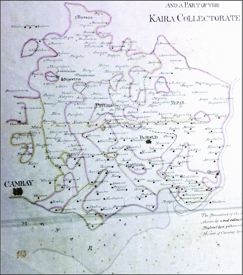
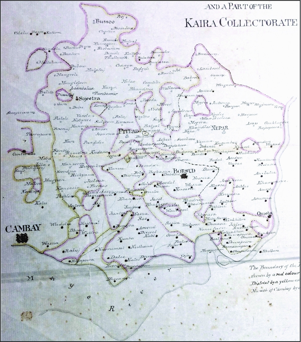
This problem is exemplified by the smuggling cases that occurred within and surrounding the Pitlad Territories (see Figure 1). By the mid-nineteenth century, the British had a treaty with the Gaekwar of Baroda that permitted him to cultivate, transport, and sell opium within the boundaries of his own lands. Pitlad held some of Baroda's most lucrative opium-producing lands but, as Lieutenant Battye, the Assistant Resident for Baroda, once remarked, the “Town of Pitlad is so nearly surrounded by British territory that it is almost impossible for opium grown in the Gaekwar Villages. . .to be conveyed from the town without passing through our villages”.Footnote 37 Consequently, even though movement of opium within Baroda was entirely legal—including the movement of opium from Pitlad to the rest of Baroda—it was costly and inefficient to do so without crossing colonial lands, an act that was illegal without a pass. Baroda merchants wishing to conduct such a shipment were therefore faced with the choice of taking the inefficient, long route to move their goods without leaving Baroda, purchasing an expensive pass granting them legal passage through British territory, or moving their product illegally. Unsurprisingly, many traders opted to forego the pass, instead illegally crossing the territories of the Bombay Presidency, using traditional off-road, inter-village routes.
Map depicting the region of western India including the Pitlad Territories and the Kaira Collectorate (part of the Bombay Presidency). The Pitlad Territories belonged to Baroda but were separated from the main state by lands belonging to the British and other princely rulers. The lands belonging to Baroda are outlined in green, while those belonging to the Presidency are outlined in pink. On the left, surrounded by yellow, is Cambay. This map was drawn by a colonial official for use during a smuggling case. Source: Revenue Department Papers (1851), MSA.
With jurisdiction questionable and the relevant policies themselves vague and contradictory,Footnote 38 prosecution of smugglers was heavily reliant on personal testimonies. The very identification of a transaction as illegal was dependent on the verbal accounts of those directly involved, most of whom had a vested interest in the outcome. The merchants had the value of the cargo itself at stake, which often represented a considerable financial investment. They also risked imprisonment or heavy fines if found guilty of smuggling. Meanwhile, local officials were typically rewarded with a portion of any seized goods, giving them a monetary incentive to ensure that seized cargo was officially labelled as illegal. Such interests certainly coloured testimonies, leading to accounts of events often differing greatly between the two sides of the debate, and even between parties on the same side.
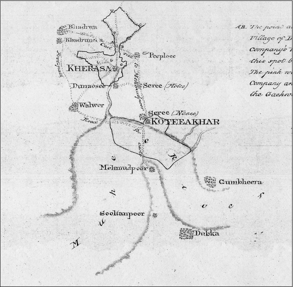
Debates of this kind became the cornerstone of the British fight against smuggling. There was ultimately a great deal of ambiguity inherent in the process of suppressing it. In order to deter smugglers the authorities in Bombay first needed a definitive system for defining particular activities as illegal: this was something they severely lacked. Local officials would seize cargo suspected of being smuggled and detain those found with it, until they could prove one way or the other that the goods had, in fact, been acquired or shipped illegally. In one 1849 case (see Figure 2), three carts of opium were seized by local officials of the Kaira Collectorate, a territory of the Bombay Presidency. The carts had been loaded in the Baroda village of Bhadun and were in transit between Bhaduren and Padra Durrapura, also of Baroda, when they were captured. The carts were detained in a heavily wooded area that lay not only between these villages of the Baroda territory, but also along a narrow stretch of colonial land. In this area, the stretch of woodland belonging to the Kaira Collectorate was only 250 metres wide. While the traders claimed they had been legitimately transporting goods within Baroda and were therefore seized illegally within the jungles of Bhaden, the colonial officials maintained that the carts had been taken inside the boundaries of the colonial village of Kherasa.
Map showing the lands where the 1849 case took place. This map also depicts the off-road, village-to-village routes commonly taken by local merchants, including the one allegedly being used by the carts in question. Source: Revenue Department (1849), MSA.
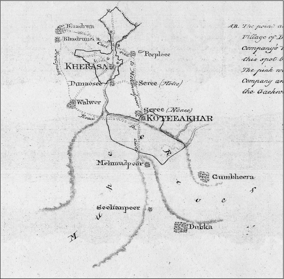
The case thus spawned a heated and lengthy debate, the main purpose of which was to determine on which side of the boundary the carts had been located when they were caught. The carts after all had been seized in the middle of the night, with none to witness the event except the merchants themselves and the officials present. It was therefore purely on them that the burden of proof was laid, with testimony from all parties being considered. As a result, the circumstances surrounding the seizure were hazy, as was the legality of those actions taken by the colonial agents. Khara Parsing, a Hindu sepoy with the coolie police stationed nearby, testified that he and an associate, acting on a tip that opium was due to be taken from Bhaden to Baroda, “captured this opium. . .there is no road going from Bhaden to Baroda without passing through the limits of Kherasa. The man that gave me this information, I do not know his name”.Footnote 39 The Collector of Kaira similarly asserted—based on the reports of his subordinates, not on personal experience—that the opium was clearly intended to be smuggled as it was “concealed under a quantity of rice—and the carts laden with such valuable commodity travelling during the night can leave no doubt of the intention of the parties”.Footnote 40 Meanwhile, the accused filed their own petition, asserting that the opium had been seized while legally within the boundaries of Baroda lands, and had been conveyed in such a manner in order to protect it from theft, with no malevolent intent.Footnote 41
Besides the immediate consequences of this case, the wider debate that it represented meant that both the Gaekwar of Baroda and the Government of Bombay were soon involved. The Gaekwar petitioned the British himself, identifying the opium as the property of the Baroda state and having been legally transported from one part of the state's territories to another. His further request for free passage for Pitlad opium through the Kherasa lands was denied, as the British Collector determined that such an allowance was “likely to cause an inconvenient precedent”, and would “no doubt tend to encourage smuggling of opium into our territory, which already prevails to a large extent”.Footnote 42 It was determined in this case that the carts had been taken legitimately, within the boundaries of the Kherasa territory, and so were guilty of carrying their goods illegally across British borders. However, the statements given above, as well as the lack of concrete evidence to support such a decision, suggest that the determination was made in no small part as a means of maintaining the fragile status quo in the region. If it had been acknowledged that the opium had been seized on Baroda lands, or that the officials had practiced any impropriety in their handling of the case, the British would have had to question the existing legal framework or concede limits to their authority in such a matter. Moreover, the arbitrariness of this decision, and its overall reliance on testimony, points to the fact that activity was labelled as illicit largely as a result of legal pragmatism and a desire to maintain the illusion of British authority over such matters.
Large-Scale Smuggling
As these examples demonstrate, what the Government in Bombay referred to as smuggling was, in many instances, simply a re-labelling of established pre-colonial networks and trade practices. Most cases, in reality, were not deliberately subversive. However, there were certainly exceptions, with some activity being clearly and intentionally illegal. The profit potential of the trade with China attracted merchants from all over India. It was impossible for any merchants operating at the time to ignore the fact that China offered the greatest potential rewards. Many of those who had previously focused their business on the sale of goods to western Asia had redirected their attention toward China by the 1820s. Though some such merchants migrated to Bombay and other colonial commercial centres to pursue their interests within the legal boundaries of the East India Company, others maintained pre-existing habits, and used prevailing networks to operate in this new commercial sector. In one case, a well-known, successful Bombay-based Marwari merchant named Motichund Amechund was caught transporting 1200 Bengal maunds (33,600 lbs) of opium from Malwa to Karachi, demonstrating similar use of transportation routes and personnel—as well as a shared interest in unregulated profits—between those operating primarily through ports such as Cambay, Diu and Karachi, and legitimate traders working from Bombay.Footnote 43 Motichund Amechund was a prominent member of Bombay business society—one of the so-called ‘Merchant Princes’—who benefited greatly from the booming trade with China. However, it is clear that such traders did not completely cut contact with existing mercantile links throughout western India, but rather diversified and adapted, just as had been the practice for centuries.
Karachi was a particularly busy port for smuggling. The route between Karachi and the Portuguese ports of Goa, Damaun and Diu remained in heavy use until the mid-nineteenth century. For most of its history, Karachi had flourished in the transhipment of goods to western Asia and Africa, but by the end of the eighteenth century its exports were largely intended for the China market. In fact, until the annexation of Sind in 1843, Karachi was perhaps the largest single shipping point for independently exported goods destined for China.Footnote 44 From Karachi, goods—mainly opium—were shipped along the coast southward to Damaun and Diu. Captain John Shepherd reported to Government in 1830 that the Bombay Presidency's total exports of Company-controlled Malwa opium amounted to 3,566 chests while the amount shipped through Damaun—which largely, but not wholly, came via Karachi—amounted to 8,908 chests.Footnote 45 Though the trade from Karachi was certainly substantial, in reality it was the perception of Karachi trade as posing a threat to British profits that had the greatest impact. Indeed, the Karachi route had become a source of enormous anxiety for the British, who saw it as seriously undermining their own opium revenues; Karachi, and the early threat it had apparently posed, remained at the forefront of smuggling-related rhetoric for many years after the annexation of Sind halted much of the illicit trade.Footnote 46
While the illicit trade was certainly sizeable, it is questionable whether the trade ever reached the volume claimed by the British, especially since the Residents and Agents stationed in so-called smuggling ports often refuted the panicked reports made by the central government.Footnote 47 Nevertheless, the very fact that it was perceived as a threat made it influential. Whether real or imagined, the idea of smuggling played a major role in the restructuring of trade in western India. British commercial interests were seen to be precarious and under constant threat from independent Indian entrepreneurship. In 1832, the Select Committee on the Affairs of the East India Company observed, “It must be recollected that the revenue thus derived is of the most precarious kind, depending as it does on a species of monopoly under which we possess exclusive control neither over the production or the consumption of the article”.Footnote 48
Anxieties over smuggling played a part in a number of political and territorial moves by the British in India during the first half of the nineteenth century. In the Karachi case, such concerns contributed heavily to the annexation of Sind, which succeeded in finally bringing the Karachi-based opium trade under the control of the Bombay Presidency. However, prior to that, visions of an immense illicit trade flowing out of Karachi impacted heavily on policies concerning the setting of tariffs and transit duties. The pass duty on opium—one pass was required for the transport of every case, or 140 lbs, of opium—was kept deliberately low in order to discourage smuggling. The pass duty was fixed at 175 Rupees per chest for a great many years. In 1835, as a result of a perceived influx in smuggling from Karachi in relation to a diminished number of shipments exported from Bombay, the duty was lowered further to 125 Rupees per chest.Footnote 49 It remained at this level until 1843. Immediately after the Sind territory's annexation was finalised, the Government in Bombay considered it no longer necessary to keep the pass duty low. With Karachi now part of the Bombay Presidency, they were able to establish a formal political foothold in Karachi, with customs officers to monitor exports and ensure payment of transit duties. As a consequence, the price of a Government Pass increased dramatically and quickly. In October 1843, the pass duty was increased from 125 Rupees to 200 Rupees per chest. By 1856, the price had reached 410 rupees, and by 1861 it was up to a staggering 600 Rupees per chest.Footnote 50
Similar methods were employed elsewhere, with smuggling concerns likewise colouring policy decisions. As in the case of Sind, the British attempted to extend their political presence in Kathiawar and Kutch as a deliberate means of preventing smuggling. Major General Sir John Malcolm remarked at one stage that he deemed the region to be “of much political importance” in large part due to its “flourishing seaport. . .and an alliance with it has enabled us to check in a very considerable degree the smuggling of Malwa Opium, which was carried on to a great extent”.Footnote 51 While political influence and diplomatic relationships enabled the suppression, to a degree, of smuggling intended for export to China, it had little impact on domestic sales. The British determined that any efforts on their part to entirely suppress the cultivation of opium in Kathiawar would be futile, since its growth was widespread within Kathiawar and neighbouring territories. They recognised that an outright prohibition would likely result in increased smuggling activity, with the home cultivated drug simply replaced by that grown next door. Instead, they opted to employ price management as a means of discouraging smuggling, lowering prices of their own product in the hopes that local consumers and merchants would choose to purchase that instead. They decided, “we should content ourselves with discouraging the growth of opium in this Province by reducing the price of the Malwa Opium supplied from the Rajcote Warehouse”.Footnote 52 On the advice of the Acting Political Agent in Kathiawar, they further determined to “call the agents of the Talookdars together, make them acquainted with the resolution of Government not to prohibit the growth of the drug, and call upon them to find themselves by some agreement. . .to prevent the exportation of the produce either by land or sea”.Footnote 53 With many of the chief cultivation grounds and smuggling ports lying outside the control of the Bombay Presidency, and with limited resources at their disposal, price management was generally the most cost-effective and diplomatic solution.
Yet, even this method was met with varying degrees of success. In Kathiawar and Kutch, as in so many other regions, opium was widely cultivated. Even with price management, unregulated products were frequently less expensive and easier to procure for local consumers. Moreover, with little assistance given by local chiefs to curtail the industry—some of whom actively profited from opium trafficking—reigning in the illicit trade was a nearly impossible task. Nevertheless, despite their general lack of success, the economic and political methods used for the protection of British customs revenues played a key role in shaping the political landscape of western India.
Conclusion
Western India was undoubtedly an active region for smuggling during the middle decades of the nineteenth century. The terrain itself and lack of well-defined boundaries between territories made it difficult to define and prosecute illegal trade. Prosecution of smuggling was heavily reliant on the cooperation of local officials and rulers, which was often not given. In some cases such cooperation was refused outright, while in others it was passively denied, with help given officially in speech or writing but not in reality.
This region possessed a long-standing history of independent commerce, with Gujarati traders holding positions of power and financial might under the Mughals, the Marathas and the Portuguese. From the late eighteenth century onwards, they further built on these networks and patterns of trade, and even on their relationship with the Portuguese themselves, to circumvent British ports and continue their own extensive commercial activities.
With the increasing incorporation of Malwa opium into the British colonial revenue system from 1818—and subsequent efforts made to extend this control over other commodities—it became more and more important to establish new parameters for legal trade. In so doing, British policy played a crucial role in marginalising certain commercial activities and thereby creating an illicit trade. This so-called illicit trade under the British, however, was in large part composed of pre-existing commercial system. Ultimately, it embodied a lack of ability on the part of the colonial government to bend or control the economy of Gujarat. With closer analysis of local smuggling activities, it is less a coordinated act of protest that emerges, but rather a widespread lack of compliance and a denial of the right of the colonial government to institute restrictions, especially in industries such as salt production that had long histories and deeply entrenched economies.
The result was that a criminally subversive smuggling network existed more in the imperial imagination than in reality. Smuggling networks instead preserved long-standing Gujarati commercial traditions and epitomised both the opportunistic exploitation of ineffective enforcement processes and a refusal to re-mould commercial structures to serve British priorities. Illicit trade, in most cases, differed little in character from the historical trade of western India or even from the legitimate trade of Bombay Presidency; it was simply labelled as such as a result of new laws, shifting boundaries, and personal testimonies. While the illicit trade certainly posed a considerable threat to imperial profits, it was as a concept that it made its greatest impact: that dangerous and subversive network agonised over by the British was, at its core, merely a figment of their own perception.