

Introduction
Even though the Intergovernmental Panel on Climate Change (IPCC) confirmed the mean global warming to be 0.6 ± 0.2°C during the twentieth century, Antarctica has undergone a much more rapid regional warming over the last 60 years (Vaughan et al. Reference Vaughan, Marshall, Connolley, Parkinson, Mulvaney and Hodgson2003). This is particularly the case in the Antarctic Peninsula, a region that covers ~540 000 km2, including several islands and archipelagos, where a rapid warming is observed (3.4°C/century; Vaughan et al. Reference Vaughan, Marshall, Connolley, Parkinson, Mulvaney and Hodgson2003). Although an absence of regional warming since the late 1990s is reported by Turner et al. (Reference Turner, White, King, Phillips, Hosking and Bracegirdle2016), who used a stacked temperature record, the overall long-term trend is of a rapid disintegration of ice shelves and a thinning and retreat of marine-terminating continental glaciers, which are likely to raise global sea levels in the near future (Bentley et al. Reference Bentley, Hodgson, Smith, Ó Cofaigh, Domack and Larter2009, Golledge et al. Reference Golledge, Levy, McKay, Fogwill, White and Graham2013). The mass loss of Antarctic ice sheets and glaciers is evident (Seong et al. Reference Seong, Owen, Lim, Yoon, Yeodong, Lee. and Caffee2009) and the trend is increasing (Shepherd et al. Reference Shepherd, Ivins, Rignot, Smith, van Den Broeke and Velicogna2018). As a result, today ~2% of the Antarctic Peninsula has become ice free. Greening due to vegetation expansion is the most obvious ecological reaction to this warming, especially along the fringes of the Antarctic Peninsula and in areas where paraglacial and periglacial processes are less intense (Oliva & Ruiz-Fernández Reference Oliva and Ruiz-Fernández2015, Amesbury et al. Reference Amesbury, Roland, Royles, Hodgson, Convey, Griffiths and Charman2017, Ruiz-Fernández et al. Reference Ruiz-Fernández, Oliva, Nývlt, Cannone, García-Hernández and Guglielmin2019). Understanding these contemporary changes in a longer-term context requires the use of palaeo-data (Small et al. Reference Small, Bentley, Jones, Pittard and Whitehouse2019), and it is therefore crucial to understand the Late Quaternary history of Antarctic Peninsula glaciers in order to better predict their future developments (e.g. Bentley et al. Reference Bentley, Johnson, Hodgson, Dunai, Freemand and Ó Cofaigh2011, Johnson et al. Reference Johnson, Everest, Leat, Golledge, Rood and Stuart2012, Ó Cofaigh et al. Reference Ó Cofaigh, Davies, Livingstone, Smith, Johnson and Hocking2014).
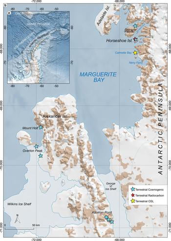
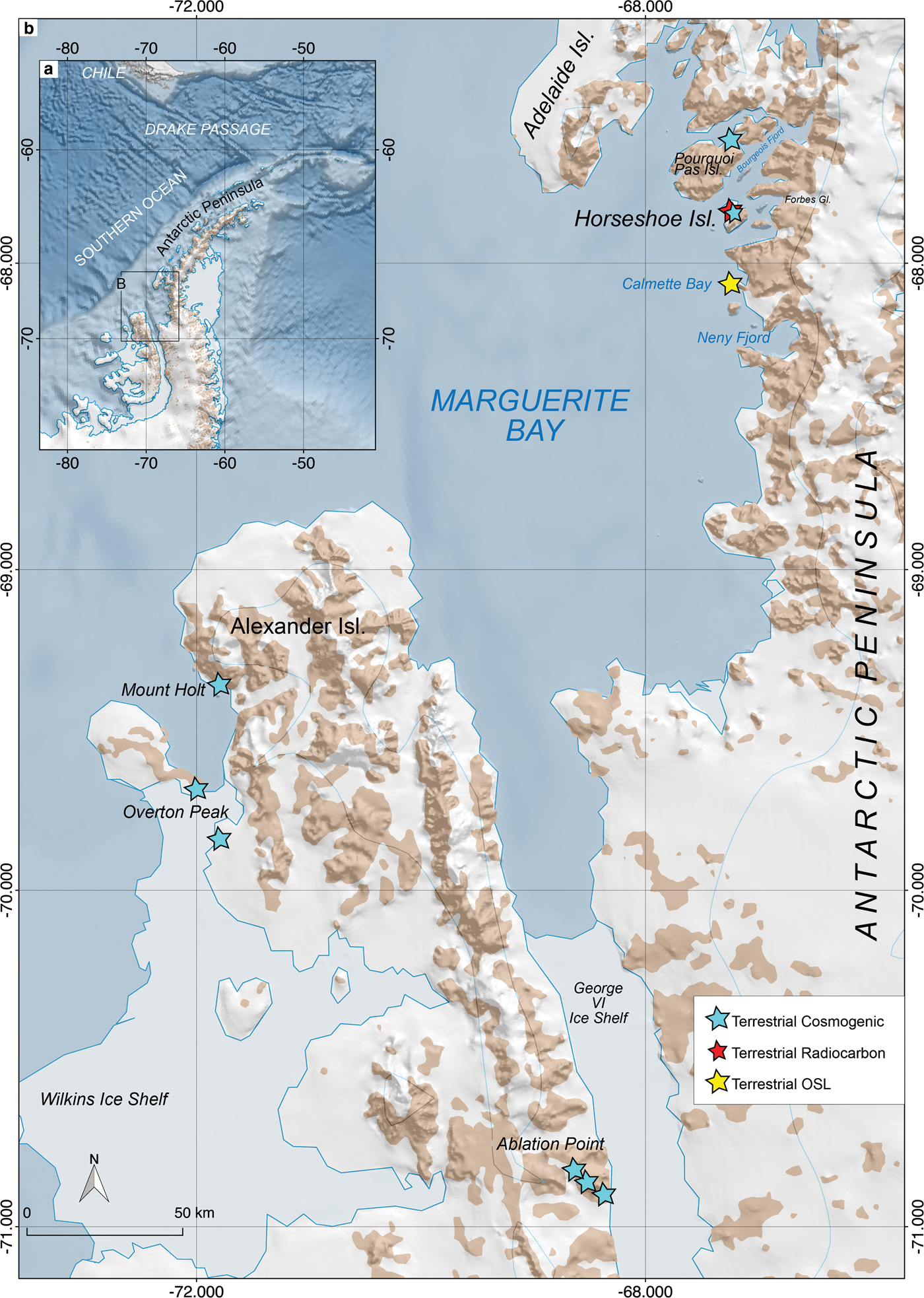
An increasing number of studies have been carried out in the Antarctic Peninsula that use a combination of offshore marine geophysical, geological and terrestrial dating techniques in order to understand the palaeo-ice sheet dynamics (e.g. Livingstone et al. Reference Livingstone, Ó Cofaigh, Stokes, Hillenbrand, Vieli and Jamieson2012, Ó Cofaigh et al. Reference Ó Cofaigh, Davies, Livingstone, Smith, Johnson and Hocking2014 and references therein) (Fig. 1). The western Antarctic Peninsula has attracted particular attention, where for example areas around the Wilkins and George VI ice shelves and the catchments of the Anvers, Belgica and Marguerite Trough ice streams have been studied in particular detail (e.g. Bentley et al. Reference Bentley, Johnson, Hodgson, Dunai, Freemand and Ó Cofaigh2011, Johnson et al. Reference Johnson, Everest, Leat, Golledge, Rood and Stuart2012). The data gathered from marine and terrestrial proxies now enable us to obtain a detailed picture of the development of this ice sheet since the Last Glacial Maximum (LGM) (Bentley et al. Reference Bentley, Hodgson, Smith, Ó Cofaigh, Domack and Larter2009, Reference Bentley, Johnson, Hodgson, Dunai, Freemand and Ó Cofaigh2011, Hodgson et al. Reference Hodgson, Roberts, Smith, Verleyen, Sterken and Labarque2013, Ó Cofaigh et al. Reference Ó Cofaigh, Davies, Livingstone, Smith, Johnson and Hocking2014). For instance, during the LGM (c. 20–25 ka), the ancestral Marguerite Trough Ice Stream (MTIS) extended to the shelf edge and occupied most parts of the bathymetric troughs that later retreated to more coastal positions (e.g. Anderson & Oakes-Fretwell Reference Anderson and Oakes-Fretwell2008, Bentley et al. Reference Bentley, Johnson, Hodgson, Dunai, Freemand and Ó Cofaigh2011, Ó Cofaigh et al. Reference Ó Cofaigh, Davies, Livingstone, Smith, Johnson and Hocking2014). Today, the Marguerite Bay region, where our study area of Horseshoe Island is located, has been interpreted as a former location of very fast ice stream retreat, as the bay area was largely free of ground ice at the onset of the Holocene except for at George VI Ice Shelf (Ó Cofaigh et al. Reference Ó Cofaigh, Dowdeswell, Evans and Larter2008, Bentley et al. Reference Bentley, Johnson, Hodgson, Dunai, Freemand and Ó Cofaigh2011) (Figs 1 & 2).
a. Location map of the Antarctic Peninsula and b. the Marguerite Bay area and Horseshoe Island. The landforms on the island were mapped using Google Earth images acquired in 2009, 2011 and 2012 and a 10 m contour interval map derived from Open Street Map Thunder Forest Landscape. OSL = optically stimulated luminescence.
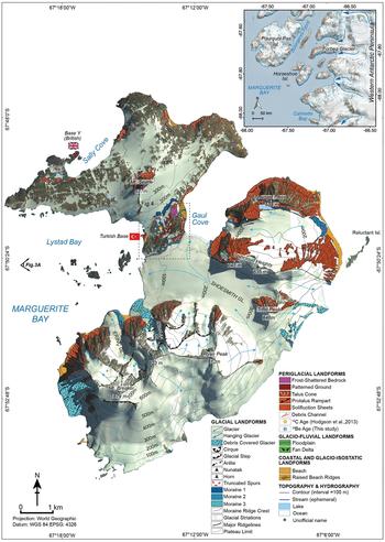
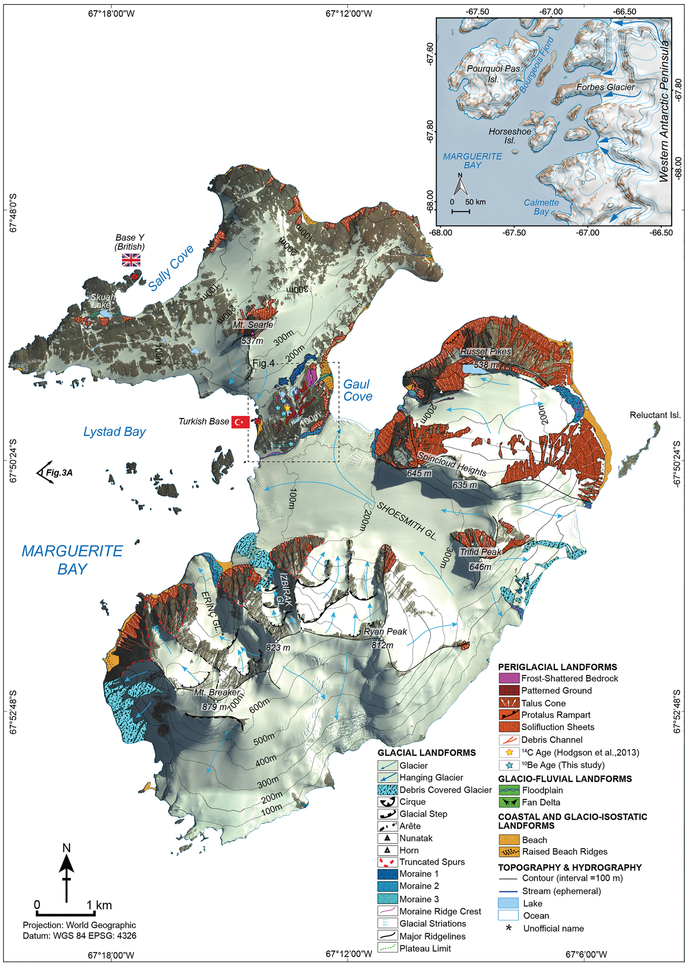
Geological and geomorphological map of Horseshoe Island on Google Earth image acquired in 2012 and a 10 m contour interval map derived from Open Street Map Thunder Forest Landscape. Map by Yıldırım (Reference Yıldırımin press). Lithological, tectonic and structural features are adapted from Matthews (Reference Matthews1983). Field reconnaissance of the landforms was carried out in March 2018.
The increasing use of cosmogenic nuclide surface exposure dating on glacially sculpted erratic boulders and bedrock surfaces and optically stimulated luminescence (OSL) dating of beach pebbles and cobbles, combined with more conventional techniques such as 14C dating of lacustrine and terrestrial deposits, help us to bracket the timing of deglaciation in Antarctica (e.g. Bentley et al. Reference Bentley, Fogwill, Kubik and Sugden2006, Reference Bentley, Johnson, Hodgson, Dunai, Freemand and Ó Cofaigh2011, Hodgson et al. Reference Hodgson, Roberts, Smith, Verleyen, Sterken and Labarque2013, Simkins et al. Reference Simkins, Simms and Dewitt2013). However, even though a general picture of the ice retreat chronology is now available in the case of MTIS, more observational and quantitative data are needed in order to better constrain its development in time and space (e.g. Johnson et al. Reference Johnson, Everest, Leat, Golledge, Rood and Stuart2012).
A survey by Small et al. (Reference Small, Bentley, Jones, Pittard and Whitehouse2019) on the online ICE-D Antarctica database extracted published data (10Be and 26Al) from sites where exposure ages were < 25 ka at altitudes > 50 m and where the original authors constrained ice sheet thinning, indicated only one location (Pourquoi-Pas Island; Bentley et al. Reference Bentley, Johnson, Hodgson, Dunai, Freemand and Ó Cofaigh2011) in the entire western Antarctic Peninsula. We also conducted a similar check (http://antarctica.ice-d.org: census date: March 2019) and counted all published 10Be data regardless of their age and altitude. The results show that only 10 areas and a total of 68 cosmogenic surface exposure ages are available, which indicates how poorly the western Antarctic Peninsula is constrained by cosmogenic ages onshore. Therefore, the aim of this paper is to contribute, via 10Be cosmogenic nuclide surface exposure dating, to the understanding of this retreat, particularly around Horseshoe Island (Fig. 2). Although several studies have been carried out on the deglaciation of the MTIS since the LGM (Bentley et al. Reference Bentley, Hodgson, Sugden, Roberts, Smith, Leng and Bryant2005a, Reference Bentley, Fogwill, Kubik and Sugden2006, Smith et al. Reference Smith, Bentley, Hodgson, Roberts, Leng and Lloyd2007, Roberts et al. Reference Roberts, Hodgson, Bentley, Sanderson, Milne and Smith2009), including cosmogenic nuclide surface exposure ages obtained on the flanks of the George VI Ice Shelf and on Pourquoi-Pas Island (Bentley et al. Reference Bentley, Johnson, Hodgson, Dunai, Freemand and Ó Cofaigh2011, Johnson et al. Reference Johnson, Everest, Leat, Golledge, Rood and Stuart2012), the only dates for the deglaciation of Horseshoe Island are limiting ages derived from basal radiocarbon dates (Hodgson et al. Reference Hodgson, Roberts, Smith, Verleyen, Sterken and Labarque2013). Therefore, we collected four samples from granite erratic boulders from Horseshoe Island in order to determine the local ice sheet deglaciation history using 10Be cosmogenic isotope dating, and we compared the results obtained with other cosmogenic, OSL and 14C ages previously gathered from the Marguerite Bay area. In the light of obtained and available published ages, we reviewed the Early Holocene position of the MTIS in Horseshoe Island.
Site descriptions
Marguerite Bay
Marguerite Bay (68°30'S, 68°30'W) is the largest embayment (~40 000 km2) of the western Antarctic Peninsula, limited by Adelaide Island to the north and Alexander Island to the south (Fig. 1). Several tidewater glaciers (e.g. Forbes Glacier) and fjords (e.g. Dogs Leg and Bourgeois fjords) can be observed along the coast of the Antarctic Peninsula on the east side of the bay (e.g. García et al. Reference García, Dowdeswell, Noormets, Hogan, Evans, Ó Cofaigh and Larter2016). In its southern part, George VI Ice Shelf flows northwards into Marguerite Bay. This ice shelf is the only remnant of the ancestral MTIS that extended to the edge of the shelf - situated 200 km to the west - hence covering the whole bay area during the LGM (Ó Cofaigh et al. Reference Ó Cofaigh, Davies, Livingstone, Smith, Johnson and Hocking2014).
Horseshoe Island
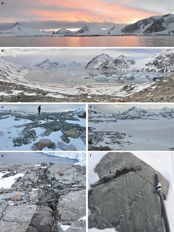
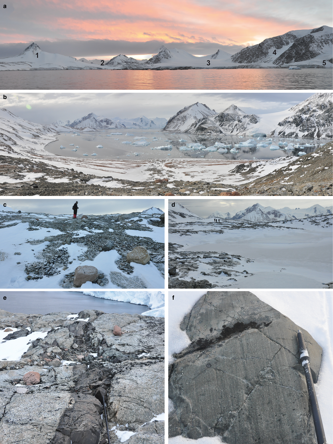
Horseshoe Island (67°51'S, 67°12'W) is one of the largest islands in Marguerite Bay and is situated ~20 km west of the terminus at the exit of Forbes Glacier (Figs 1 & 2). The island has a total surface area of ~60 km2, where two-thirds of it is covered by glaciers or semi-perennial ice and snow. The northern part of the island shows a low-lying and subdued topography with exposed bedrock dominated by pyramidal Mount Searle (537 m above sea level (a.s.l.)) (Fig. 3a). The British Antarctic Survey research station, Base Y, which served between 1955 and 1960, is found near Skua Lake along the shore of Sally Cove. The south-western part of the island is more mountainous and rugged and is dominated by Mount Breaker (879 m a.s.l.), where its southern side is highly glaciated with ice cliffs on the south-western coastline (Matthews Reference Matthews1983). The largest glacier on the island, Shoesmith Glacier, flows to the north-west and bifurcates into two branches. Its less active branch flows towards the north and calves into Gaul Cove (Fig. 3b). Its more active and larger branch flows westwards into Lystad Bay. From east to west, several nunataks are also observed with their southern flanks almost completely covered by glaciers. Two small, unnamed glaciers, flowing towards the north-west, were unofficially named as Sırrı Erinç and Reşat İzbırak glaciers, dedicated to the memory of two prominent Turkish geographers (Fig. 2). The island is divided by a narrow, largely ice-free central col ~80–100 m a.s.l. between its northern and southern parts, where five freshwater lakes are situated (Fig. 3c). Hodgson et al. (Reference Hodgson, Roberts, Smith, Verleyen, Sterken and Labarque2013) carried out limnological and sedimentological studies on one of these clear water lakes, unofficially called Col Lake 1, which is 162 m long, 64 m wide and 3.2 m deep, situated at an altitude of ~80 a.s.l. (Figs 3d & 4).
a. Horseshoe Island from Lystad Bay; 1. Mount Searle, 2. central col area, 3. Shoesmith Glacier, 4. & 5. İzbırak and Erinç glaciers (unofficial names). b. The Gaul Cove; icebergs originating from Shoesmith Glacier to the right and several uplifted marine terraces in the background. c. Pink erratic granite boulders scattered on basic country rock in the col area. d. Frozen Col Lake 3. e. Basic dyke cutting through the gneiss; pink erratics on the bedrock. f. Ice striations on bedrock surfaces in the col area indicate east to west flow.
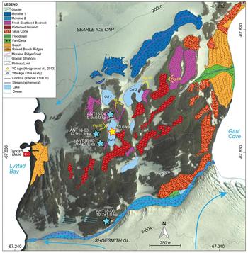
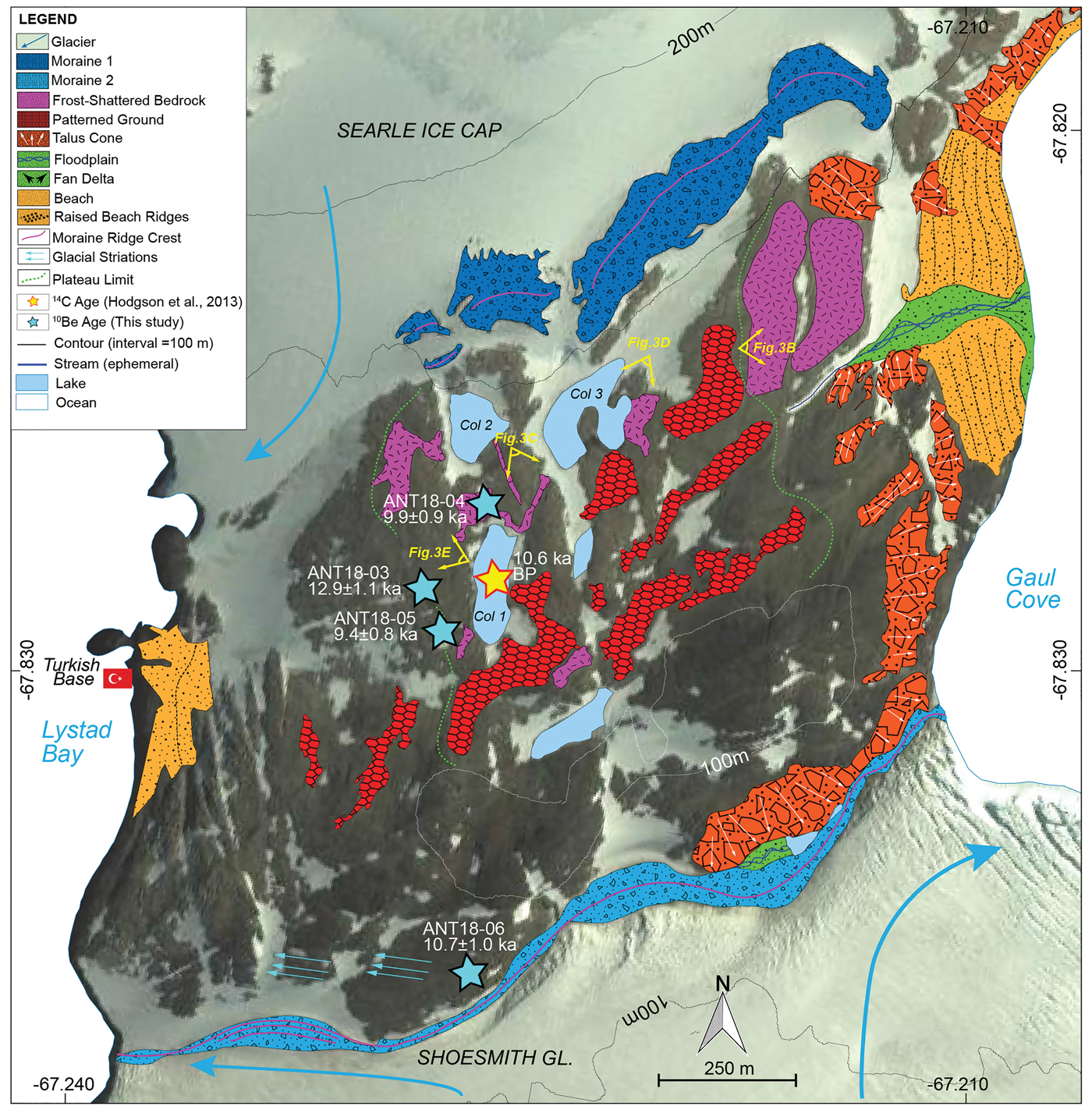
Detail map of the col area on Horseshoe Island. Cosmogenic ages from erratic blocks and field picture locations are indicated.
Several morainic ridges, well-polished and striated pink granite erratic cobbles and boulders (up to 1 m in size) scattered throughout the island on bedrock, talus material along mountain fronts and cliffs, frost-shattered country rock and regolith, beach cobbles and fluvial pebbles of small, braided streams make up some of the Quaternary landforms and deposits of the island (Fig. 3e). Matthews (Reference Matthews1983) noted that at the northern part of the island glacial striations are oriented east to west and point towards Forbes Glacier at the mainland (Fig. 3f). Thus, during more extensive glaciation, Forbes Glacier probably flowed over the northern and central col of the island towards the west, probably exposing the higher parts of Mount Searle as a nunatak, and it would have formed part of a tributary to the MTIS. Later, when the MTIS started to thin, the granite boulders carried out by the ice sheet from the mainland and/or from the eastern part of the island were laid down as erratics.
Today, the Marguerite Bay area is affected by cold and dry maritime climatic conditions, where meteorological measurements at British Rothera (between 1977 and 2015) and Argentinian San Martin (between 1985 and 2015) stations, ~50 km to the north-west and ~30 km to the south of the study area, indicate mean annual air temperatures as -4.3°C and -4.6°C, respectively (Oliva et al. Reference Oliva, Navarro, Hrbáček, Hernandéz, Nývlt, Perreira, Ruiz-Fernández and Trigo2017).
The base rocks of Horseshoe Island are composed of foliated granitic gneisses of the Antarctic Peninsula Metamorphic Complex (Matthews Reference Matthews1983) (Fig. 2). Overlying pink granite is only observed on the northern part of the island. Foliated volcanic rocks and sediments, particularly observed along the col, belong to the Antarctic Peninsula Volcanic Group (Matthews Reference Matthews1983). Several granitic intrusions with colours ranging from white to pink to brick-red, together with gabbro and diorite, constitute the so-called Andean Plutonic Suite. In the north-western part, successive gabbroic and granitic intrusions and copper mineralization with distinctive malachite green-coloured veins can be observed. The rocks are highly fractured, sometimes with small faults, and are often cut by several metres-thick basic dykes that can be traced for several hundreds of metres.
Methodology
Fieldwork and mapping
We carried out a total of 1 week of fieldwork, where we mapped the geomorphological and geological features and collected samples from pink to brick-red granite erratic cobbles and boulders for 10Be cosmogenic surface exposure dating purposes.
Cosmogenic nuclide dating
We used the cosmogenic surface exposure dating method to infer the depositional ages of the erratic boulders collected from Horseshoe Island. The exposure time of an erratic boulder since its deposition by an ice sheet and/or glacier can be estimated by this method (Stone et al. Reference Stone, Balco, Sugden, Caffee, Sass, Cowdery and Siddoway2003). Here, we used in situ produced cosmogenic 10Be. As the production rate of 10Be is known, the measured 10Be concentrations in rocks can be used to quantify the duration of boulder exposition (Lifton et al. Reference Lifton, Sato and Dunai2014, Borchers et al. Reference Borchers, Marrero, Balco, Caffee, Goehring and Lifton2016).
We collected four samples for cosmogenic 10Be dating from the top of the erratic pink-red granite boulders and cobbles that were scattered on the bedrock. We did not undertake bedrock sampling in order to avoid any potential nuclide inheritance, which can occur under cold-based ice in Antarctica (Balco et al. Reference Balco, Stone, Sliwinski and Todd2014). We used a hammer and chisel to collect samples from the upper few centimetres of the boulders and the thicknesses of the samples were recorded (Table I). All collected erratic boulders show clear evidence of transportation such as well-developed polish and striations. Totals of 0.4–1.0 kg of rock chips were collected from each erratic boulder depending on the ease of sample collection. Sample collection was extremely difficult because of the well-polished surfaces. We collected three samples from the largest possible boulders, which were available in relatively flat areas and far away from slopes in order to avoid toppling or post-depositional movement effects, hence the young exposure ages. We also collected one erratic cobble, where we cut horizontally the upper 3 cm that was later used to extract the sample for preparation. Shielding of surrounding topography was measured by inclinometer from the horizon at each sample location. Sample location and elevation data were recorded by a handheld GPS device. In order to minimize the snow shielding effect, all of the samples were collected on the relatively flat col area where strong winds are often present. We also ensured that we were far away from the slopes in order to avoid potential snow accumulation on the samples.
Cosmogenic age data used in this study. Ages have been calculated using the CRONUS Earth Web Calculator v.2 (http://cronus.cosmogenicnuclides.rocks) (Marrero et al. Reference Marrero, Phillips, Borchers, Lifton, Aumer and Balco2016) with a mean attenuation length of 151.8 g cm−2, rock density of 2.65 g cm−3 and the Lifton/Sato flux time-dependent scaling scheme (known as LSD or SF) based on Lifton et al. (Reference Lifton, Sato and Dunai2014). Choice of a different scaling scheme (i.e. Lal/Stone time independent, ST; Stone Reference Stone2000) would make the ages ~6% older. Blank correction applied. No snow or erosion correction applied. Isotope ratios were referenced to 07KNSTD standard.

a.s.l. = above sea level, WGS = World Geodetic System.
The rock samples were first crushed and sieved to a grain size of 0.25–0.71 mm at Istanbul Technical University's ITU/Kozmo-Lab (www.kozmo-lab.itu.edu.tr/en). Crushed samples were rinsed with Milli-Q® and leached overnight with 10% nitric acid (HNO3), and they were later sent to Seoul, Korea, for further preparation. The crushed samples were chemically treated in order to remove all of the minerals except for pure quartz at the Geochronology Laboratory, Korea University, following the method outlined by Seong et al. (Reference Seong, Dorn and Yu2016). The samples were leached with either 3% or 1% hydrofluoric acid (HF)/HNO3 solution in an ultra-sonicator and heating roller. After extraction of pure quartz, ~20 g of quartz per sample were dissolved in a highly concentrated mixture of HF and HNO3 with the addition of a low background carrier of 9Be (~400 µg). After the quartz was completely dissolved, the solution was dried on a hotplate at 280°C. Fluorides were removed from the samples by perchloric acid (HClO4) fuming three times. Matrix contamination by elements such as Fe, Ca and Ti was eliminated by ion exchange chromatography (anion-cation chromatography) using resins filled with the exchangeable anion of Cl (1-X8) and exchangeable cation of H+ (50W-X8). Using OH precipitation, Be was extracted as BeCl2 by ion chromatography, samples were neutralized and beryllium hydroxide (Be(OH)2) was formed by adding ammonium hydroxide (NH4OH). Be(OH)2 was then combusted at 800°C for ~10 min in a furnace in order to form beryllium oxide (BeO), while ammonium salt was evaporated. Targeted accelerator mass spectrometer (AMS) measurements of 10Be concentrations were conducted on a mixture of BeO and Nb powder (BeO/Nb = 1:1) in target cathodes using a 6 MV tandem AMS at the Korea Institute of Science and Technology.
The measured 10Be/9Be values of each sample were normalized and corrected with a 10Be/9Be ratio of the fixed standard sample, 10Be-01-05-1 of 07KNSTD, and the blank sample (average ratio of the full chemistry processing blanks (n = 2) was 10Be/9Be = 1.6 × 10⁻¹⁵). Then, corrected beryllium isotope ratios were converted into beryllium concentrations (atoms g−1).
Ages were calculated using the production rates provided by the CRONUS Earth Web Calculator v.2.0 (http://cronus.cosmogenicnuclides.rocks) (Marrero et al. Reference Marrero, Phillips, Borchers, Lifton, Aumer and Balco2016) with a mean attenuation length of 151.8 g cm−2. We used the Lifton/Sato flux time-dependent scaling scheme (known as LSD or SF) based on Lifton et al. (Reference Lifton, Sato and Dunai2014). Corrections for sample thickness and topographic shielding were applied. Sample densities were assumed as 2.65 g cm−3. Since erosion rates are considered to be very low and difficult to estimate in Antarctica (Johnson et al. Reference Johnson, Everest, Leat, Golledge, Rood and Stuart2012), we neglected the erosion on rock surfaces. However, erosion rates obtained from much colder and drier parts of Antarctica, such as Dry Valleys and Transantarctic Mountains, are typically very low (10 cm Ma−1; Balco et al. Reference Balco, Stone, Sliwinski and Todd2014). Even if higher erosion rates were applied (e.g. 20 cm Ma−1), an increase in age of only up to few hundred years (150–300 years) is calculated (Johnson et al. Reference Johnson, Everest, Leat, Golledge, Rood and Stuart2012). We therefore reported only the zero-erosion boulder ages for our samples. Because of the exposed (wind-scoured) locations and poor constraints on past snowfall, we have assumed no snow shielding, consistent with other studies (e.g. Bentley et al. Reference Bentley, Johnson, Hodgson, Dunai, Freemand and Ó Cofaigh2011). All essential information, including the 10Be concentrations and scaling factors to reproduce resultant ages, is given in Table I.
Results
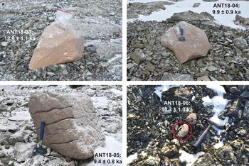
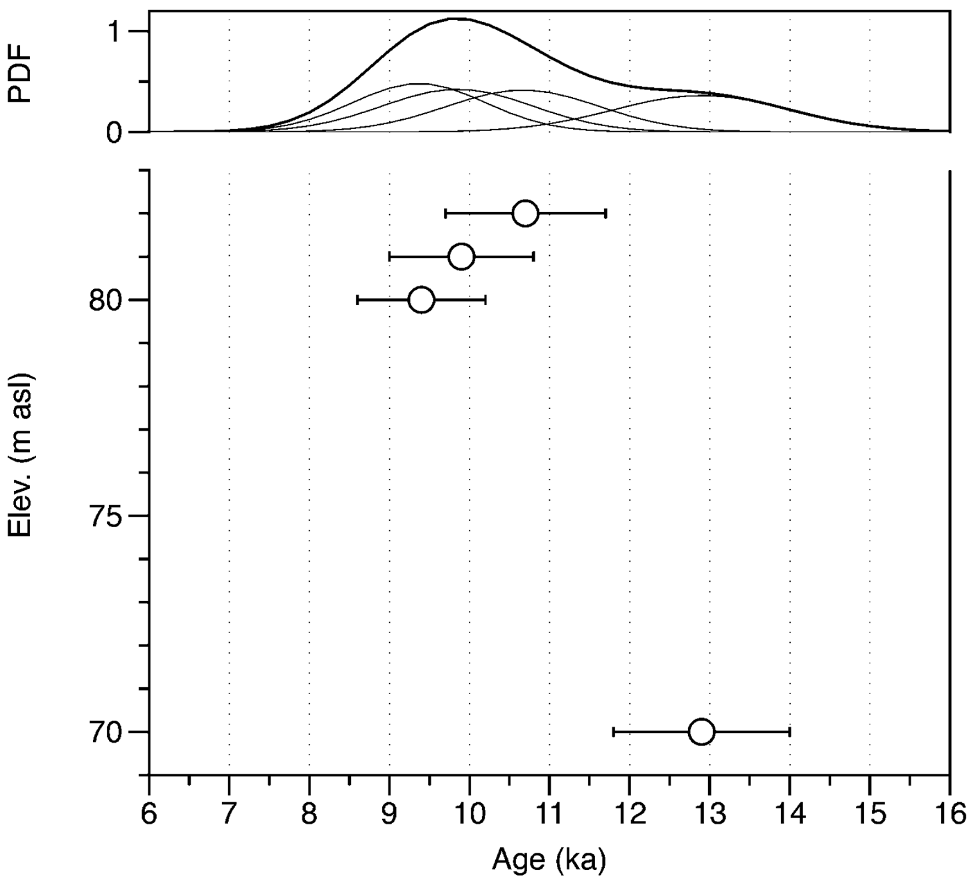
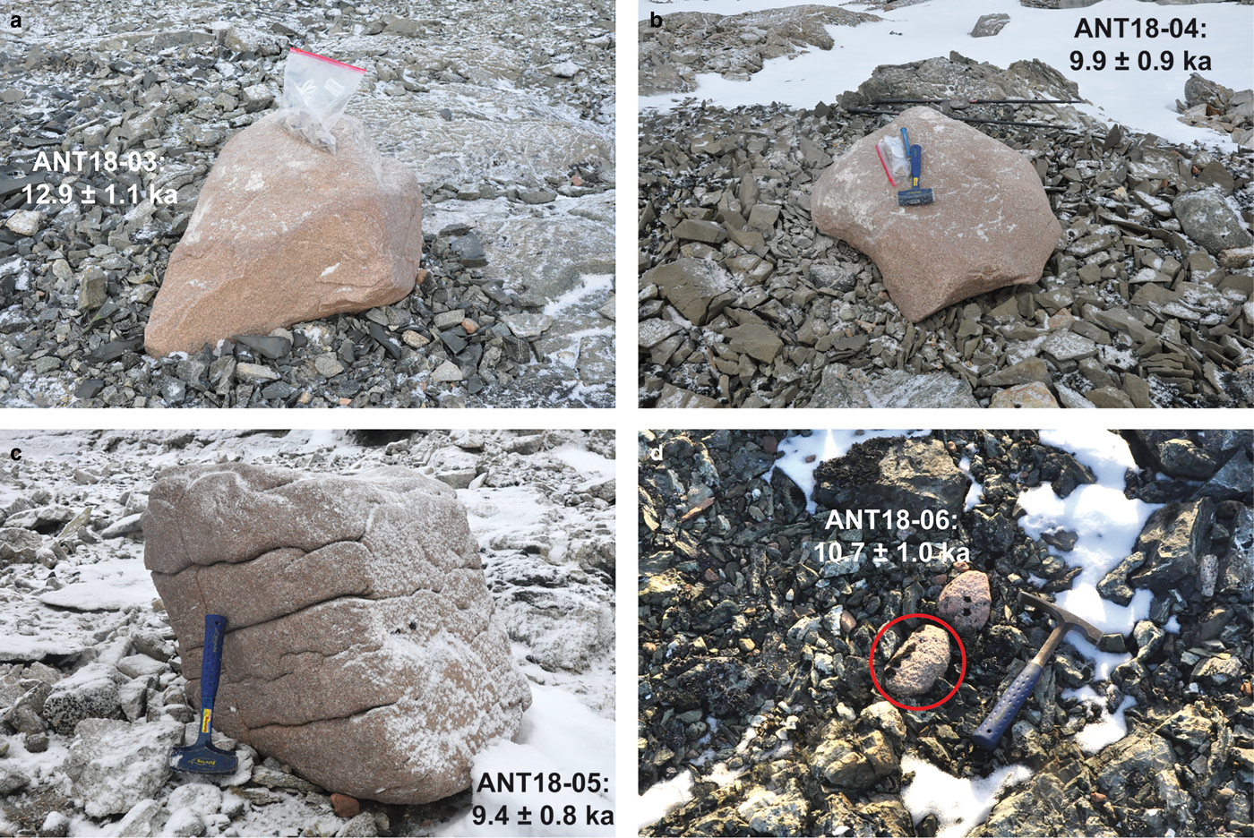
The 10Be ages of four samples change from 12.9 ± 1.1 ka (ANT18-03) to 9.4 ± 0.8 ka (ANT18-05). The sample that yielded the oldest age (ANT18-03: 12.9 ± 1.1 ka) was collected from an erratic pink granite that is well rooted into frost-shattered and dark-coloured dyke fragments exposed on the col area at 70 m a.s.l. (Figs 4 & 5a). The second sample (ANT18-04) is a flat-lying erratic pink granite boulder and was also collected from the col area at 80 m a.s.l., and it yielded an age of 9.9 ± 0.9 ka (Figs 4 & 5b). The third erratic pink granite boulder sample collected from the col area is ANT18-05, which gave an age that was similar to the previous one (9.4 ± 0.8 ka) (Figs 4 & 5c). The fourth and last sample (ANT18-06) is a small erratic cobble collected from the southern-most part of the col area overlooking the Shoesmith Glacier (Figs 4 & 5d). Although it is relatively distant and much smaller than the previous samples, its age (10.7 ± 1.0 ka) is similar to the previous erratic boulders. It is also worth mentioning that the fresh-looking moraine (~80 m a.s.l.) deposited by the Shoesmith glacier is now found ~100 m to the south of sample ANT18-06 (collected at 82 m a.s.l.; 10.7 ± 1.0 ka). Although not presented in this study, we also collected and dated several moraine pebbles that yielded much younger ages (unpublished data). In conclusion, samples from the col area produced consistent ages, indicating a deglaciation at the onset of the Holocene (Fig. 6).
a–d. Pictures of the collected erratic granite boulders and cobbles. Sample IDs and exposure ages are indicated on each picture. Location of samples are indicated in Fig. 4.
Cosmogenic exposure ages for Marguerite Trough Ice Stream (MTIS) retreat on Horseshoe Island. The lower panel shows the individual sample ages with 1σ uncertainties plotted against the elevation of the samples, and the upper panel shows the probably density functions (PDFs) of the samples. Average ages of the samples are indicated by thick black PDF curves.

Discussion
Cosmogenic age interpretation
Although our dataset of four 10Be ages might seem relatively small, considering the difficult conditions specific to Antarctica and the low number of published ages, we believe that even presenting small datasets will help to constrain the thinning and retreat of the MTIS, at least near to Horseshoe Island. All four samples were collected from the col area at altitudes ranging between 70 and 82 m a.s.l., and all four 10Be ages yielded an internally consistent dataset with a weighted average age of 10.7 ± 0.8 ka. The fact that sample ANT18-06 was collected from an area near to the Shoesmith moraine, with similar altitudes but very different ages, indicates that there has been no re-advance of the ice sheet since the onset of the Holocene.
In the case of moraine boulders, it is common practice to calculate the age of a landform by taking its weighted average after the exclusion of outliers (e.g. Applegate et al. Reference Applegate, Urban, Keller, Lowell, Laabs, Kelly and Alley2012). However, because of various geomorphic processes acting on the landscape, a wide scatter of ages can be observed, and hence the weighted average method could sometimes become problematic. By contrast, other researchers use the oldest age to indicate the landform age (e.g. Putkonen & Swanson Reference Putkonen and Swanson2003). A comprehensive study carried out using a large dataset from the Tibetan Plateau concluded that the incomplete exposure (post-depositional shielding) model's performance was much better compared to that of the prior exposure (inheritance) model (Heyman et al. Reference Heyman, Stroeven, Harbor and Caffee2011). On the other hand, in the case of erratic boulders, several studies in the Antarctic Peninsula (e.g. Bentley et al. Reference Bentley, Johnson, Hodgson, Dunai, Freemand and Ó Cofaigh2011, Johnson et al. Reference Johnson, Everest, Leat, Golledge, Rood and Stuart2012) use the minimum age to infer the deglaciation time of the area. We therefore chose to use the youngest age (9.4 ± 0.8 ka) to report the time when the surface became ice free in the col area in Horseshoe Island. Nevertheless, the oldest (12.9 ± 1.1 ka), weighted average (10.7 ± 0.8 ka) and youngest (9.4 ± 0.8 ka) ages are within the error ranges and do not substantially change the main conclusion, which is the Early Holocene deglaciation pattern near the Horseshoe Island area.
Bentley et al. (Reference Bentley, Johnson, Hodgson, Dunai, Freemand and Ó Cofaigh2011) reported cosmogenic exposure ages from Parvenu Point of nearby Pourquoi-Pas Island (25 km to the north of our sampling location), which represent the only available data from the Marguerite Bay area. The results obtained from six boulders indicate a tight clustering (from 10.5 to 9.6 ka), with only one reworked sample (18 ka) considered as an outlier. Bentley et al. suggest that the erratics were freshly exposed at deglaciation and further propose an ice sheet thinning from 350 to 77 m a.s.l. over a very short time interval in Pourquoi-Pas Island. As with many other studies carried out in Antarctica (e.g. Stone et al. Reference Stone, Balco, Sugden, Caffee, Sass, Cowdery and Siddoway2003), Bentley et al. (Reference Bentley, Johnson, Hodgson, Dunai, Freemand and Ó Cofaigh2011) also used the youngest age (9.6 ka) to propose the closest deglaciation time. In order to be consistent with our scaling scheme (Lifton/Sato), we recalculated Bentley et al. (Reference Bentley, Johnson, Hodgson, Dunai, Freemand and Ó Cofaigh2011) ages and concluded that their ages would be ~6% younger. In other words, their youngest age, interpreted by the authors as the closest deglaciation time, would be 9.4 ka instead of 9.6 ka. Provided that we also use the youngest age (9.4 ka) from our dataset, it becomes clear that the deglaciation of the MTIS was synchronous in this part of Marguerite Bay. Using the recalculated weighted average (9.6 ka) or the oldest (9.7 ka) ages from Bentley et al.'s (Reference Bentley, Johnson, Hodgson, Dunai, Freemand and Ó Cofaigh2011) study or from our datasets (10.7 ka and 12.9 ka, respectively) would not substantially change the results, as they remain within the error limits.
Marine and lacustrine data for ice retreat timing
Other proxies, not only on land but also in the marine realm, also indicate a rapid thinning of the MTIS across Marguerite Bay. The retreat chronology of the Antarctic Peninsula ice sheet has been a major research topic, but because of the large and variable marine reservoir and reworking effects on Antarctic marine sediments, 14C chronologies are sometimes difficult to interpret. However, Heroy & Anderson (Reference Heroy and Anderson2007) compiled a list of ‘reliable 14C ages’ (their table 1) and concluded that the retreat of the Antarctic Peninsula ice sheet was between c. 18 and 9 ka, generally in phase with the Northern Hemisphere deglaciation and eustatic sea-level rise. It is also reported that the retreat was progressive from the outer towards the inner continental shelf areas and from the north towards the south following the lift-off of the grounded ice (Heroy & Anderson Reference Heroy and Anderson2007, Ó Cofaigh et al. Reference Ó Cofaigh, Davies, Livingstone, Smith, Johnson and Hocking2014).
In the outer shelf of Marguerite Bay, deglaciation started after c. 14 ka (Heroy & Anderson Reference Heroy and Anderson2007), where MTIS experienced rapid but topographically controlled retreat and thinning of ~200 km, compared to shallower inter-ice stream banks where grounded ice persisted for longer durations (Livingstone et al. Reference Livingstone, Ó Cofaigh, Stokes, Hillenbrand, Vieli and Jamieson2012, Reference Livingstone, Ó Cofaigh, Stokes, Hillenbrand, Vieli and Jamieson2013). Grounded ice remained on the mid- and inner shelf until a second deglacial stage of rapid thinning and retreat at 9.6 ka, as indicated by cosmogenic age data from Pourquoi-Pas Island (Bentley et al. Reference Bentley, Johnson, Hodgson, Dunai, Freemand and Ó Cofaigh2011) and also from our study. This two-step deglacial model has already been proposed by previous studies (Heroy & Anderson Reference Heroy and Anderson2007, Allen et al. Reference Allen, Oakes-Fretwell, Anderson and Hodgson2010, Kilfeather et al. Reference Kilfeather, Ó Cofaigh, Lloyd, Dowdeswell, Xu and Moreton2011), but it is Bentley et al.'s (Reference Bentley, Johnson, Hodgson, Dunai, Freemand and Ó Cofaigh2011) work that confirmed for the first time the timing of the second deglacial step.
Kilfeather et al. (Reference Kilfeather, Ó Cofaigh, Lloyd, Dowdeswell, Xu and Moreton2011) provided sedimentological and foraminiferal assemblage evidence and radiocarbon ages on foraminifera indicating that the final onset of hemipelagic sedimentation on the mid-shelf occurred between 9.3 and 9.6 ka in the MTIS. In addition, the extrapolation of relative sea-level curves obtained from 14C dates on penguin bones also supports the idea that deglaciation of the inner part of Marguerite Bay occurred prior to 9 ka (Bentley et al. Reference Bentley, Hodgson, Smith and Cox2005b). Sedimentary analyses of the base of a 12 m marine core from Neny Fjord (50 km to the south of our sampling location) indicates that deglaciation of the fjord occurred prior to 9 ka, which provides a minimum deglaciation timing near the coastal areas (Allen et al. Reference Allen, Oakes-Fretwell, Anderson and Hodgson2010). The same study also concludes that the Neny Fjord had not been overridden by glacier ice during the Holocene based on the continuous deposition of ice-distal sediments and the presence of seasonally open-water diatoms. On the other hand, Guglielmin et al. (Reference Guglielmin, Worland, Convey and Cannone2012), using Schmidt Hammer data, have proposed a deglaciation age for the Marguerite Bay area of c. 12 ka, which is somewhat earlier than previously reported ages (e.g. Bentley et al. Reference Bentley, Hodgson, Smith and Cox2005b), including our cosmogenic age data.
It is also reported that the George VI Ice Shelf collapsed and probably melted from above and below at c. 9.6 ka bp and reformed at c. 7.7 ka bp, indicating that there may have been an Early Holocene intrusion of intermediate-depth warm water (Bentley et al. Reference Bentley, Hodgson, Sugden, Roberts, Smith, Leng and Bryant2005a, Reference Bentley, Hodgson, Smith, Ó Cofaigh, Domack and Larter2009, Reference Bentley, Johnson, Hodgson, Dunai, Freemand and Ó Cofaigh2011, Smith et al. Reference Smith, Bentley, Hodgson, Roberts, Leng and Lloyd2007, Allen et al. Reference Allen, Oakes-Fretwell, Anderson and Hodgson2010). While the present-day western coastline of the Antarctic Peninsula ice sheet reached its current position by 7–9 ka, the eastern Antarctic Peninsula ice sheet deglaciation was much later (Bentley et al. Reference Bentley, Hodgson, Smith, Ó Cofaigh, Domack and Larter2009, Reference Bentley, Johnson, Hodgson, Dunai, Freemand and Ó Cofaigh2011, Ó Cofaigh et al. Reference Ó Cofaigh, Davies, Livingstone, Smith, Johnson and Hocking2014).
In addition to marine proxies, several lacustrine data gathered from islands within Marguerite Bay indicate an Early Holocene deglaciation (e.g. Hodgson et al. Reference Hodgson, Roberts, Bentley, Smith, Johnson and Verleyen2009, Reference Hodgson, Roberts, Smith, Verleyen, Sterken and Labarque2013, Roberts et al. Reference Roberts, Hodgson, Bentley, Sanderson, Milne and Smith2009). In fact, the radiocarbon ages obtained from the lake cores on Horseshoe Island show that the col area experienced a non-erosive glacial regime from 35 780 (38 650 to 33 380) or 32 910 (34 630 to 31 370) cal yr bp onwards with multiple ice-free intervals (Hodgson et al. Reference Hodgson, Roberts, Smith, Verleyen, Sterken and Labarque2013). In the col area, the earliest onset of a deglaciation event is indicated by the presence of moss fragments at 28 830 (29 370 to 28 320) cal yr bp, followed by another deglaciation event indicated by the colonization of Branchinecta gaini at 21 110 (21 510 to 20 730 interpolated) cal yr bp. Based on above data, Hodgson et al. (Reference Hodgson, Roberts, Smith, Verleyen, Sterken and Labarque2013) proposed that at least one part of the ice sheet of the inner Marguerite Bay was < 140 m thick (relative to present sea level) at that time. Clear evidence of the onset of Holocene deglaciation on land is shown by the presence of aquatic moss fragments in Col Lake 1 at 10 610 (11 000 to 10 300) cal yr bp, which was followed by a peak abundance of B. gaini eggs at 9830 (9940 to 9720 interpolated) cal yr bp, accompanied by a decrease in dry mass suggesting a well-established freshwater biota (Hodgson et al. Reference Hodgson, Roberts, Smith, Verleyen, Sterken and Labarque2013). Our cosmogenic ages from erratic boulders and all available lacustrine data clearly indicate the rapid thinning of the MTIS within the Marguerite Bay archipelago.
The isolation of Skua Lake in Horseshoe Island (Figs 2 & 4) at c. 1.3 ka (Wassell & Håkansson Reference Wassell and Håkansson1992), today found at 3.5 m a.s.l. (and only 1 km to the south of our youngest erratic sample location), also indicates the continuing isostatic adjustment following the ice removal. On nearby Pourquoi-Pas Island, Parvenu Point and Narrows Lake data suggest a local sea level at 19.4 m at 6.5 ka and a deglacation time between 9.6 and 8.8 ka bp (Bentley et al. Reference Bentley, Hodgson, Sugden, Roberts, Smith, Leng and Bryant2005a, Reference Bentley, Johnson, Hodgson, Dunai, Freemand and Ó Cofaigh2011, Hodgson et al. Reference Hodgson, Roberts, Smith, Verleyen, Sterken and Labarque2013). Our work confirms the Early Holocene deglaciation of Horseshoe Island, but also clearly highlights the importance of gathering further cosmogenic age data in order to better constrain the deglaciation time of the Marguerite Bay area.
Conclusions
Four cosmogenic 10Be exposure ages from Horseshoe Island in Marguerite Bay, collected from three erratic pink granite boulders and one granite cobble at altitudes of between 82 and 70 m a.s.l., produced consistent ages; 12.9 ± 1.1 ka, 10.7 ± 1.0 ka, 9.9 ± 0.9 ka and 9.4 ± 0.8 ka. Following other studies carried out in Antarctica on erratics, we have also chosen to report the youngest erratic age (9.4 ± 0.8 ka) as the true age of deglaciation, which confirms a rapid thinning of the MTIS at the onset of the Holocene. Using the weighted average or oldest ages from our datasets (10.7 and 12.9 ka, respectively) would not substantially change the results, as they remain within the error limits. This result closely matches cosmogenic age data and other proxies (marine and lacustrine 14C and OSL ages) reported from nearby areas.
Acknowledgements
This study was carried out under the auspices of the Turkish Republic Presidency, supported by the Ministry of Science, Industry and Technology and coordinated by the Istanbul Technical University (ITU) Polar Research Center (PolReC) and the ITU Research Fund (BAP) Project No. 9. We thank the Chilean captains and crew of the Antarctic Warrior vessel and our colleagues who helped us during the fieldwork. We also thank Greg Balco who created the ICE-D Antarctica database, which allows the comparison of data across the continent. We are grateful to Mike Bentley and an anonymous reviewer for their constructive suggestions, which greatly improved the quality of the paper.
Author contributions
AÇ and CY carried out the fieldwork. MAS and YBS prepared the samples in their laboratories in Turkey and Korea, respectively. BYY measured the samples using accelerator mass spectrometry in Korea. AÇ wrote the paper. All of the authors read and approved the manuscript.