Introduction
The study of human mobility has manifold political and ethical implications. Individual and group mobility patterns arise from varied factors, such as environmental conditions, economic needs and changing technological capacities. The investigation of mobility requires consideration of factors such as: the distance between places; temporal scales and rhythms of movement; the size of groups and the portion of the community that move; and the motivations of those on the move. Recent archaeological work has gone beyond the crude dichotomy of sedentary vs mobile groups, and of the simplistic view of mobility as an adaptive response to environmental conditions, in order to explore human mobility as a multifaceted phenomenon (e.g. Barnard & Wendrich Reference Barnard and Wendrich2008; Makarewicz Reference Makarewicz2013; Porter Reference Porter2012; Sellet et al. Reference Sellet, Greaves and Yu2015).
A significant shift in mobility patterns occurred during the long-term process towards sedentary life associated with agropastoralism. Neolithic communities continued to rely on hunting and gathering, but remained highly mobile at different spatial scales. In northern Mesopotamia, pottery Neolithic societies maintained a high degree of mobility (Akkermans Reference Akkermans, Nieuwenhuyse, Bernbeck, Akkermans and Rogasch2013); during the sixth millennium BC, Halaf groups circulated items, customs and ideas, uniting distant communities (Akkermans & Schwartz Reference Akkermans and Schwartz2003: 153; Frangipane Reference Frangipane, Nieuwenhuyse, Bernbeck, Akkermans and Rogasch2013). The mobility of Halaf groups also took place at smaller spatial scales, indicating fissional phenomena of parts of the community, recursive movements centred on focal sites, or settlement shifts at single locations (Bernbeck Reference Bernbeck, Barnard and Wendrich2008, Reference Bernbeck, Nieuwenhuyse, Bernbeck, Akkermans and Rogasch2013; Bernbeck & Nieuwenhuyse Reference Bernbeck, Nieuwenhuyse, Nieuwenhuyse, Bernbeck, Akkermans and Rogasch2013). Thus, the very concepts of ‘community’, ‘site’ and ‘cultural landscape’ must be fully re-examined when dealing with Late Neolithic mobility in South-western Asia, where social groups were frequently “multi-sited” (Bernbeck Reference Bernbeck, Barnard and Wendrich2008: 63–65) or integrated communities (Barth Reference Barth and Nelson1973). The well-preserved landscape of the Mil Plain in Azerbaijan offers a unique opportunity to explore the mobility practices of early agricultural communities and their adaptive strategies towards incipient sedentism.
State of research on the Neolithic of the southern Caucasus
Over the last 15 years, research on the prehistory of the southern Caucasus has dramatically intensified (see Lyonnet et al. Reference Lyonnet, Guliyev, Helwing, Aliyev, Hansen and Mirtskhulava2012: 1–3, on Soviet-period research). A number of problem-oriented international investigations (e.g. Marro et al. Reference Marro, Bakhshaliyev and Ashurov2011; Guliyev & Nishiaki Reference Guliyev, Nishiaki, Matthews, Curtis and Seymour2012; Hansen et al. Reference Hansen, Mirtskhulava, Bastert-Lamprichs, Nieuwenhuyse, Bernbeck, Akkermans and Rogasch2013; Badalyan et al. Reference Badalyan, Smith, Lindsay, Harutyunyan, Greene, Marshall, Monahan and Hovsepyan2014; Lyonnet et al. Reference Lyonnet, Guliyev, Bouquet, Bruley-Chabot, Samzun, Pecqueur, Jovenet, Baudouin, Fontugne, Raymond, Degorre, Astruc, Guilbeau, Dosseur, Benecke, Hamon, Poulmarc'h and Courcier2016), as well as interdisciplinary projects, including the ‘Ancient Kura’ (Lyonnet et al. Reference Lyonnet, Guliyev, Helwing, Aliyev, Hansen and Mirtskhulava2012) and ‘Kura in Motion!’ (Helwing et al. Reference Helwing, Aliyev, Lyonnet, Guliyev, Hansen and Mirtskhulava2017a) initiatives, provide a basic cultural-chronological framework for the prehistory of the region. This research demonstrates that Neolithic communities settled in the Kura Valley at the onset of the sixth millennium BC, with no evidence for a preceding pre-pottery Neolithic phase (Nishiaki et al. Reference Nishiaki, Guliyev and Kadowaki2015).
Preliminary genetic studies on sheep and cattle from Aruchlo in Georgia confirm the external origin of livestock (Scheu Reference Scheu2012; Geörg Reference Geörg2013), which were introduced to the southern Caucasus in their fully domesticated forms (Benecke Reference Benecke, Helwing, Aliyev, Lyonnet, Guliyev, Hansen and Mirtskhulava2017). The first sedentarisation of the southern Caucasus has been related to two external currents of cultural influence: one linked to eastern Anatolia and northern Mesopotamia, and another connected to the Iranian highlands (Arimura et al. Reference Arimura, Badalyan, Gasparyan and Chataigner2010: 83; Lyonnet et al. Reference Lyonnet, Guliyev, Helwing, Aliyev, Hansen and Mirtskhulava2012; Helwing & Aliyev Reference Helwing, Aliyev and Museibli2017a). The dynamics of the spread of Neolithic lifestyles are still not fully understood, but strong regional variability characterised the first phase of sedentary occupation. A large-scale abandonment of the low alluvial plains occurred c. 5300 BC, lasting until c. 4800 BC, possibly coinciding with a phase of regional aridification (Joannin et al. Reference Joannin, Ali, Ollivier, Roiron, Peyron, Chevaux, Nahapetyan, Tozalakyan, Karakhanyan and Chataigner2014). Mentesh Tepe is one of the few documented sites occupied during this phase (Lyonnet et al. Reference Lyonnet, Guliyev, Bouquet, Bruley-Chabot, Samzun, Pecqueur, Jovenet, Baudouin, Fontugne, Raymond, Degorre, Astruc, Guilbeau, Dosseur, Benecke, Hamon, Poulmarc'h and Courcier2016); the question of whether settlement shifted to the mountains during these centuries cannot currently be answered because upland areas have not been systematically investigated. Despite all these recent findings, the nature of the early Neolithisation in the Caucasus is still debated.
A frozen landscape: the Mil Plain
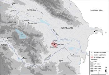
The Mil Plain lies in the southern part of the Republic of Azerbaijan, stretching east of the Lesser Caucasus foothills, west of the confluence of the Kura and Aras Rivers, and north-west of the Mugan Plain (Figure 1). The plain itself is flat, open and incised by tributaries of the Kura River. In this landscape, nearly every natural or anthropogenic feature is highly visible and becomes a crucial navigational landmark. The name Mil derives from the tower or minaret that stood in the medieval city of Beylaqan, modern Ören Qala (Rösler Reference Rösler1898: 304), and provided a vital navigational point for the caravans that crossed the plain.
Map of the south-eastern Caucasus, showing the location of the archaeological sites mentioned in the text and the area of investigation covered by the Mil Plain Survey.

Climatically, the region is classified as subtropical and semi-arid. Average rainfall is less than 250mm per year, but strong seasonal and inter-annual variations occur. This setting provides generally unstable conditions for dry-farming agriculture. Highly permeable sand and silt sediments absorb the majority of water resources (Ollivier & Fontugne Reference Ollivier, Fontugne, Lyonnet, Guliyev, Helwing, Aliyev, Hansen and Mirtskhulava2012: 125–26), accentuating the risks of practising agriculture. Sparse Artemisia-like plants constitute the modern primary vegetation type, yet anthracological studies suggest the presence of riparian woodland during the sixth millennium BC (Neef et al. Reference Neef, Decaix, Tengberg, Helwing, Aliyev, Lyonnet, Guliyev, Hansen and Mirtskhulava2017: 375–76).
During the second half of the twentieth century, the Mil Plain was primarily exploited for herding, and remained at the margins of Soviet land-amelioration programmes. Following the collapse of the USSR, the area witnessed regional conflict; one effect was the disconnection of the Mil Plain from the complementary pastureland of the Qarabagh Mountains. The contemporaneous political situation, combined with relatively low soil fertility, curtailed the introduction of large-scale mechanised agriculture and urban development until recent years. Such conditions have preserved a unique ‘landscape of survival’, offering an opportunity for a fine-grained exploration of early phases of occupation in the region.
Archaeological research in the Mil Plain
As in most of the southern Caucasus, previous archaeological research has largely neglected this marginal land with two exceptions. From the 1950s, the Azerbaijan Archaeological Expedition to the Mil Steppe completed regional reconnaissance, opened test trenches at Kamiltepe and Şaxtepe, and excavated the northernmost of three massive kurgans of Üç Tepe, and a smaller Iron Age kurgan immediately south of Kamiltepe (Iessen Reference Iessen1965). This expedition identified painted sherds as ‘Mil Steppe Painted Ware’, the pottery production associated with the earliest sedentary occupation in the region. Without directly comparable ceramic material, Iessen preliminarily dated this pottery to the Eneolithic period (i.e. Chalcolithic), based on general affinities with Kültepe (Nakhchivan) and Mesopotamian Halaf materials. Later, Narimanov conducted further research at several sites in south-western Azerbaijan, including Kamiltepe (Narimanov Reference Narimanov1987). He considered the painted pottery to be a local production, with affinities to the ceramics of Mugan sites, such as Alikemektepesi. Broad parallels to the Halaf notwithstanding, these early investigations revealed the local character of the early Mil Plain occupation, which can neither be associated with the Shomu-Shulaveri culture of the Kura River Corridor, nor to the Aknashen-Aratashen Neolithic horizon of the Lesser Caucasus (Helwing et al. Reference Helwing, Aliyev, Lyonnet, Guliyev, Hansen, Mirtskhulava, Helwing, Aliyev, Lyonnet, Guliyev, Hansen and Mirtskhulava2017b) (see Figure 1).
In 2009, a joint interdisciplinary Azerbaijani-German project resumed excavation at Kamiltepe to explore the nature of its occupation and provide a regional chronological framework for the prehistoric period (Aliyev & Helwing Reference Aliyev and Helwing2009; Helwing & Aliyev Reference Helwing, Aliyev, Lyonnet, Guliyev, Helwing, Aliyev, Hansen and Mirtskhulava2012; Helwing & Aliyev Reference Barnard and Wendrich2017b). Since 2010, investigations intensified through the ‘Kura Projects’ (Lyonnet et al. Reference Lyonnet, Guliyev, Helwing, Aliyev, Hansen and Mirtskhulava2012; Helwing et al. Reference Helwing, Aliyev, Lyonnet, Guliyev, Hansen and Mirtskhulava2017a), with the aim of investigating human-environment interactions along the Kura Corridor. Recent studies include collaborative excavation and archaeological surveys, among which the Mil Plain Survey (MPS) has played a crucial role.
A landscape dotted with Late Neolithic sites
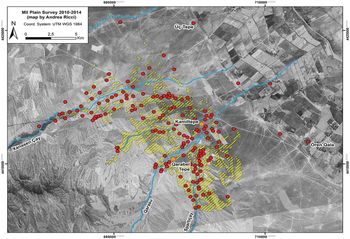
The Mil Plain Survey has conducted intensive landscape investigations over six seasons to reconstruct human settlement dynamics for the entire Holocene. Archaeological sites and features have been detected through general reconnaissance, remote-sensing analyses, geomorphological investigations and intensive pedestrian and equestrian surface survey, including transect and block-based collections (Ricci Reference Ricci, Helwing, Aliyev, Lyonnet, Guliyev, Hansen and Mirtskhulava2017). The landscape study has mapped 174 sites over approximately 55km2 (Figure 2). The investigation has documented phases of intensive occupation during the mid sixth millennium BC, the first half of the first millennium BC, and alternating with long periods of lower settlement density between the third and thirteenth centuries AD. The cycles of abandonment, following phases of intense occupation, have helped to preserve the archaeological record of the preceding periods. In particular, the complete absence of Early and Middle Bronze Age sites is crucial for the study of the earlier occupations, as these are not buried under thick Bronze Age layers. This creates excellent conditions in which to study the Late Neolithic socio-cultural milieu of the Mil Plain.
Map showing the location of all the sites from all of the periods documented by the Mil Plain Survey. Yellow polygons indicate the areas of the intensive pedestrian and equestrian survey (base map: Corona image DS1110, 24 May 1970).

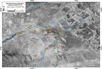
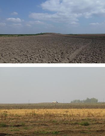
Sixty-five sites dated to the mid sixth millennium BC provide evidence for the first settlement of the Mil Plain (Figure 3). It is unlikely that all these sites were inhabited or in use simultaneously, but their number suggests a dense occupation. Sites are located between 200m and 2.5km apart. The majority are low mounds of less than 1m in height (Figure 4), and less than 1ha in area (Figure 5). Excavations at 11 sites demonstrate their limited stratigraphic sequences, reflecting sites with short occupational histories. It seems that the Late Neolithic settlement of the Mil Plain was probably therefore characterised by the frequent abandonment and relocation of sites. Occupations shifted frequently, rather than being limited to a small number of sites settled for long periods of time. Such practices did not lead to the formation of high settlement mounds of the type found across South-western Asia and South-eastern Europe, and at other contemporaneous sites in the southern Caucasus. At the ‘Shomu-Shulaveri’ settlements, approximately 250km farther north, for example, the accumulation of occupational layers formed larger and higher mounds, suggesting more stable settlement during the earliest phases of sedentary occupations (Ricci Reference Ricci, Helwing, Aliyev, Lyonnet, Guliyev, Hansen and Mirtskhulava2017). These sites were probably used for communal storage as well as habitation (Hamon Reference Hamon2008: 90; Hansen Reference Hansen2011: 19). Interestingly, however, despite several metres of deposits, they may have been in use for relatively short periods of time (Nishiaki et al. Reference Nishiaki, Guliyev, Kadowaki and Omori2018).
Map showing the location of the mid sixth-millennium BC Late Neolithic sites documented by the Mil Plain Survey (base map: Corona image DS1110, 24 May 1970).

Sites MPS 100 (upper) and 124 (lower): two examples of shallow Late Neolithic mounds (photographs by A. Ricci).

Graph of the size of the mid sixth-millennium BC sites of the Mil Plain Survey (note that the size of eight sites was impossible to determine).

Returning to the Mil Plain, excavations at several sites have documented the highly varied nature of Late Neolithic settlement (Helwing & Aliyev Reference Helwing, Aliyev, Helwing, Aliyev, Lyonnet, Guliyev, Hansen and Mirtskhulava2017b). Some sites encompassed large-scale structures, such as the three concentric ditches at MPS 4, the function of which remains an enigma (Helwing & Aliyev Reference Helwing, Aliyev, Helwing, Aliyev, Lyonnet, Guliyev, Hansen and Mirtskhulava2017b: 27–35). Some included solid structures of domestic character such as at MPS 5 (Helwing & Aliyev Reference Helwing, Aliyev, Lyonnet, Guliyev, Helwing, Aliyev, Hansen and Mirtskhulava2012: 13–15) and 103 (D'Anna Reference D'Anna, Helwing, Aliyev, Lyonnet, Guliyev, Hansen and Mirtskhulava2017), while others were more ephemeral, such as a ditch and a number of pits at MPS 124 (Ahadi Reference Ahadi, Helwing, Aliyev, Lyonnet, Guliyev, Hansen and Mirtskhulava2017; Fassbinder & Becker Reference Fassbinder, Becker, Helwing, Aliyev, Lyonnet, Guliyev, Hansen and Mirtskhulava2017: 331–33). When present, architecture is built of unburnt mud-bricks, arranged to form either sub-rectangular or sub-circular structures. Archaeobotanical and zooarchaeological studies have confirmed the extensive exploitation of fully domesticated flora and fauna, denoting an agro-pastoral economy (Astruc et al. Reference Astruc, Samzun, Gratuze, Lyonnet, Guliyev, Helwing, Aliyev, Hansen and Mirtskhulava2012; Benecke Reference Benecke, Lyonnet, Guliyev, Helwing, Aliyev, Hansen and Mirtskhulava2012, Reference Benecke, Helwing, Aliyev, Lyonnet, Guliyev, Hansen and Mirtskhulava2017; Neef et al. Reference Neef, Decaix, Tengberg, Helwing, Aliyev, Lyonnet, Guliyev, Hansen and Mirtskhulava2017).
The 23 available radiocarbon dates from the excavated sites indicate that the Late Neolithic occupation of the region lasted from c. 5650–5625 to c. 5350–5325 BC (Table S1; Helwing & Aliyev Reference Helwing, Aliyev, Helwing, Aliyev, Lyonnet, Guliyev, Hansen and Mirtskhulava2017b: 41–42, tab. 2 for discussion of available 14C dates). The combination of these data with the pottery studies supports the identification of at least two major occupation phases on the plain: the first characterised by monochrome pottery production (D'Anna Reference D'Anna, Helwing, Aliyev, Lyonnet, Guliyev, Hansen and Mirtskhulava2017), and the second by a painted assemblage with influences from north-western Iran (Aliyev & Helwing Reference Aliyev and Helwing2009; D'Anna Reference D'Anna, Lyonnet, Guliyev, Helwing, Aliyev, Hansen and Mirtskhulava2012; Helwing & Aliyev Reference Helwing, Aliyev, Helwing, Aliyev, Lyonnet, Guliyev, Hansen and Mirtskhulava2017b).
The first occupation of the plain was intensive but lasted no longer than three centuries. As in other regions of the southern Caucasus, settlement then retreated and the Mil Plain was entirely abandoned for at least six centuries.
Qarabel Tepe: a multi-mounded site
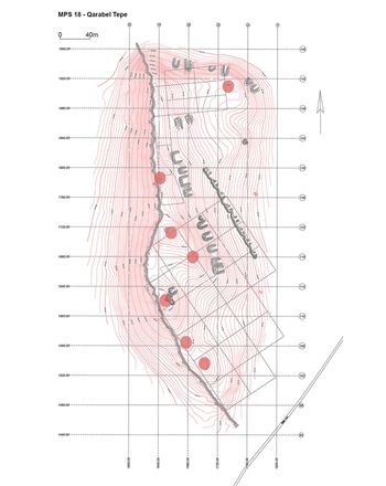
In a landscape densely dotted with small sites, Qarabel Tepe (MPS 18) is an exception. Located on a river terrace rising up to eight metres above the right bank of the Qarasu River Valley, Qarabel Tepe is the largest Late Neolithic occupation recorded in the Mil Steppe. Surface scatters of pottery and lithic tools are spread over approximately 8ha, across a series of seven low rises, located between 40 and 150m apart (Figure 6). Together, they comprise a large, multi-mounded site, unique among the Late Neolithic settlements of the region. The mid sixth-millennium BC community at Qarabel Tepe probably repeatedly relocated the settlement within the alluvial terrace, which provided protection from flooding. Subsequent small occupations shifted within the larger area of Qarabel Tepe and resulted in the formation of a cluster of small, distinct mounds located close to one another. It is possible that during these shifts, the micro-mounds were settled contemporaneously and formed a larger community. This reconstruction also suggests that the Qarabel Tepe community, or at least part of it, lived at this location for limited periods, moving away and returning to resettle, but they did not always install the structures in exactly the same locations. This dynamic might have taken place on a seasonal, yearly or longer-term basis. At present we are not able to address possible socio-cultural changes behind these repeated movements.
Topographic map of Qarabel Tepe, site MPS 18. The red-circled areas indicate the position of the seven small but distinct mounds that compose the site (map by Anne Kwast).

In 2015, excavation of one of the micro-mounds located in the central, higher part of Qarabel Tepe documented two large sub-circular mud-brick buildings with internal partitions and rich pottery assemblages, including painted ware. In the same area, a floor level delimited by two mud-brick walls, located at a lower elevation than the two round buildings, was exposed in a section. Here, abundant pottery was recovered, including undecorated local wares as well as painted sherds stylistically reminiscent of the Hajji Firuz assemblage of north-western Iran (Ricci Reference Ricci, Lyonnet, Guliyev, Helwing, Aliyev, Hansen and Mirtskhulava2012: 137, figs 175–77). Three radiocarbon dates obtained from in situ contexts indicate that the Qarabel Tepe occupation spanned between c. 5625 and 5350 BC (Helwing & Aliyev Reference Helwing, Aliyev, Helwing, Aliyev, Lyonnet, Guliyev, Hansen and Mirtskhulava2017b: tab. 2, see SU18). So far, Qarabel Tepe is the only site in the region that shows continuous occupation throughout the local Late Neolithic. The surface collection does not provide sufficient detail to identify possible gaps in occupation, as the recovered sherds are comparable to both the local earlier monochrome and later painted assemblages of the mid sixth millennium BC (Ricci Reference Ricci, Lyonnet, Guliyev, Helwing, Aliyev, Hansen and Mirtskhulava2012: fig. 175). The survey could not detect horizontal spatial patterns in the assemblage, or associations between individual micro-mounds and specific ceramic types. As these two assemblages are not contemporaneous (Helwing & Aliyev Reference Helwing, Aliyev, Helwing, Aliyev, Lyonnet, Guliyev, Hansen and Mirtskhulava2017b: 41–42), it is probable that not all areas of the site were simultaneously settled. In other words, the area of 8ha does not reflect the total size of a single Late Neolithic site, but rather, the current unbroken spread of artefacts is the result of taphonomic processes, including recent ploughing.
Future investigations will focus on dating the occupation and use of the individual low tepes, including the gaps between each occupational phase. Together with analyses of isotopes, ceramic composition and a study of the nature and use of the structures at Qarabel Tepe, this investigation will help to elucidate the frequency with which settlement shifts occurred and provide an understanding of whether all or only part of the community participated in this movement. Nonetheless, the data indicate that shifting settlement locations within Qarabel Tepe reflect a distinctive dimension, rhythm and practice of occupation and mobility not documented elsewhere in the region.
An anchoring place: Kamiltepe
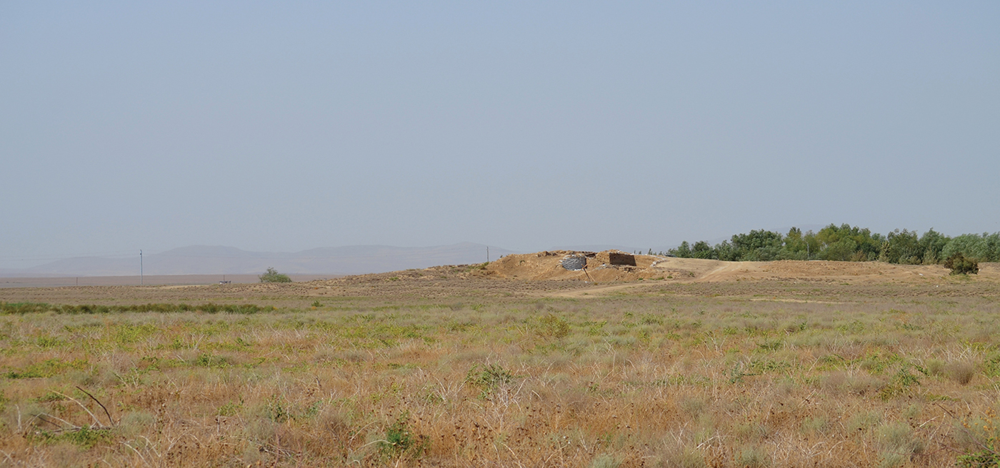
Kamiltepe lies on a low alluvial terrace of the Qarasu River, 4.6km downstream from Qarabel Tepe. Covering an area of less than half a hectare, Kamiltepe appears to be another of the numerous small Late Neolithic sites of the region. Excavations have, however, documented a massive sub-circular platform that forms the core of the site. This structure was constructed of unburnt mud-brick, with a diameter of approximately 24m (Helwing & Aliyev Reference Helwing, Aliyev, Helwing, Aliyev, Lyonnet, Guliyev, Hansen and Mirtskhulava2017b: fig. 10). Its monumental character has no direct comparison across the southern Caucasus (Helwing & Aliyev Reference Helwing, Aliyev, Bieliński, Gawlikowski, Koliński, Ławecka, Sołtysiak and Wygnańska2014), and its erection probably required a large number of people and significant labour coordination. Although the upper layers of this construction are no longer preserved, the platform still rises some 2.6m above the surroundings (Figure 7). Abundant burnt material has been documented outside the platform and in multiple deposits of debris in buildings attached to the northern and western sides of the platform. The presence of copious burnt building material, vegetation (Shillito Reference Shillito, Lyonnet, Guliyev, Helwing, Aliyev, Hansen and Mirtskhulava2012) and animal bones, including remains of little bustards (Tetrax tetrax) and other wild animals (Benecke Reference Benecke, Lyonnet, Guliyev, Helwing, Aliyev, Hansen and Mirtskhulava2012, Reference Benecke, Helwing, Aliyev, Lyonnet, Guliyev, Hansen and Mirtskhulava2017), provides indirect evidence that fires were repeatedly set on the upper, now removed, portion of the platform. Large open bowls and cooking containers recovered in the same burnt deposits indicate the preparation and consumption of foodstuffs (Helwing & Aliyev Reference Helwing and Aliyev2009; D'Anna Reference D'Anna, Lyonnet, Guliyev, Helwing, Aliyev, Hansen and Mirtskhulava2012). The majority of these ceramic fragments conjoin, suggesting that complete or already broken pots were moved away from the platform, together with burnt organic remains, when the structure was cleaned.
View of Kamiltepe from the east. The site is still highly visible in the flat landscape of the Mil Plain, despite the erosion of the upper layers (photograph by A. Ricci).

With its monumental platform, Kamiltepe was a focal location for the other mid sixth-millennium BC settlements of the Mil Plain. People gathered here and performed community-anchoring practices, activities that encompassed the construction of the platform, feasting (Aliyev & Helwing Reference Aliyev and Helwing2009: 41–42), as well as other possible ritual and habitual activities, including cooking and eating together. Given the small size of Kamiltepe and its estimated small population, it seems probable that the inhabitants of small sites located immediately around Kamiltepe or farther along the Qarasu River gathered at this anchoring location. The commensal practices reinforced the shared identity of the multi-sited community of the Mil Plain. Its first inhabitants lived in small, dispersed hamlets, which often shifted location, but maintained and fostered a shared identity, as reflected by their material culture. The position and visibility of Kamiltepe's platform was a crucial feature: with no major natural landmarks on the plain, the platform provided a prominent and convenient point of orientation, visible from a distance of several kilometres. Fires set on top of the structure and the consequent smoke would have further increased the visibility of the site.
Experimentation through mobility
Repetitive shifts in the location of the sites might relate to adaptive approaches towards sedentary lifeways. The sediments of the Mil Plain do not offer ideal conditions for farming. In this marginal environment, early agriculture and herding strategies encompassed a high degree of experimentation, as confirmed by the diverse nature of the sites. This suggests that different choices regarding mobility, economy and settlement were made, encompassing more ephemeral features such as pits filled with debris (MPS 124), circular ditches (MPS 4 and 124), or built domestic structures (MPS 5 and 103). Risk-reduction strategies possibly included exploration of different areas to find suitable locations for settlement and farming. With irregular water supply, minor changes in the water regime led to aridification at a local scale. Frequent shifts in tributary rivers linked to eustatic movements of the Caspian Sea profoundly affected settlement location decisions (Ollivier et al. Reference Ollivier, Fontugne, Lyonnet and Chataigner2016), and may have led to settlement movements to remain close to water. Socio-cultural dynamics, such as changes in economic strategy or social structure, including at individual or family levels, may also have triggered changes in the location of sites. Whether increased social tension towards the end of the Late Neolithic similarly played a role in mobility practices requires further investigation; this may explain the use of numerous sling pellets found at Kamiltepe.
Aspects of the Late Neolithic occupation and mobility of the Mil Plain closely recall some Late Neolithic communities in northern Mesopotamia. During the seventh and sixth millennia BC, semi-mobile communities lived in small sites along the Khabur, Balikh and Euphrates Valleys. Here, multi-scalar rhythms of complex mobility included the displacement of sites at short distances from previous occupations (Akkermans & Schwartz Reference Akkermans and Schwartz2003: 126). The evidence also suggests that some inhabitants remained on site year-round, while others moved on a seasonal basis (Bernbeck & Nieuwenhuyse Reference Bernbeck, Nieuwenhuyse, Nieuwenhuyse, Bernbeck, Akkermans and Rogasch2013). Moreover, patterns of residential mobility, with shifts in the location of individual structures and houses at a site level, are documented at sites such as Sabi Abyad (Akkermans Reference Akkermans, Nieuwenhuyse, Bernbeck, Akkermans and Rogasch2013) and Fistikli Höyük (Bernbeck Reference Bernbeck, Barnard and Wendrich2008).
These traits are also seen in the Mil Plain sites; there are, however, differences. The short time span and the diverse features of the occupation at the foothills of the southern Caucasus contrast with the longer occupations and more standardised architecture in the Halaf examples. In the Mil Plain, movements primarily took place at a local scale, and wild resources played a limited role, suggesting different economic strategies than in the Halaf case. Regardless, the evidence indicates that practices of complex mobility shaped Late Neolithic ways of life in both regions.
Conclusion
The rich information afforded by the combination of intensive survey and excavation has enabled the reconstruction of the first occupation of the Mil Plain during the mid sixth millennium BC. Across the region, the presence of many small sites with short life cycles, rather than a smaller number of larger, long-term occupations, suggests that locations were selected for settlement and then abandoned shortly thereafter. The Late Neolithic occupation of this precarious marginal landscape was characterised by the frequent relocations of these small sites. This is also visible at a local level, as seen in the formation process of the multi-mounded site of Qarabel Tepe. A landscape dotted by low mounds creates a horizontal stratigraphy rather than a vertical one: consequently, we might think of sites as located through time next to each other rather than above each other. Coupled with the abandonment of the region after 5350 BC, this phenomenon did not favour the formation of high tells comparable to those in Greater Mesopotamia or along the Kura Corridor in the southern Caucasus.
The reasons and timing of these repetitive shifts in the location of settlements require further exploration. Such shifts do not, however, necessarily reflect exclusively social or economic changes; mobility was itself an intrinsic element of the sixth-millennium BC way of life. Within the Mil Plain landscape, the anchoring site of Kamiltepe and its platform was a highly recognisable feature, functioning as a place for assembly and communal activities that strengthened the sense of belonging and formation of socio-cultural connectivities. The reason or reasons for the sudden abandonment of the region at the end of this phase remains unclear. After the intense occupation of the highly mobile initial sedentary community, the entire Mil Plain was abandoned for at least six centuries. The population may have moved away due to profound changes in subsistence practices, environmental conditions and social organisation. This and other questions regarding the Late Neolithic of this region of the southern Caucasus remain. As we continue to develop a more complete chrono-cultural framework, the answers will become clearer.
Acknowledgements
The German Research Foundation and the Agence Nationale de la Recherche provided support in the framework of the ‘Ancient Kura’ and ‘Kura in Motion!’ projects. The National Geographic Society (‘Stability Through Movement’ grant: NGS1481-5) and the German Archaeological Institute provided funding for investigations of the Mil Plain. Thanks also go to the Cotsen Institute of UCLA and the Archaeological Institute of America for a fellowship provided to A. Ricci for a period of study at UCLA. Special thanks go to Maisa Rahimova, Necef Müseyilibli, Svend Hansen, Amelia Fiske, Anne Kwast, Mark Iserlis and two anonymous reviewers for their assistance with this manuscript.
Supplementary material
To view supplementary material for this article, please visit https://doi.org/10.15184/aqy.2018.230