1. INTRODUCTION – JOHN KEMP
This is the third in a series of papers about various aspects of merchant ship navigation in the mid-20th Century. Previous papers concerned Soundings (Kemp et al Reference Kemp, Cockcroft, Gyldén, Iijima, Koburger, Lyon, Page and Thirslund2008) and Compasses (Kemp et al Reference Kemp, Cockcroft, Gyldén, Jurdzinski, Lyon, Page, Sellers and Thirslund2010). As with those papers, this compilation is intended to encourage our fellow ancient mariners to record their experiences of navigating ships in the middle years of the 20th century. This is recent history, but it is history all the same and we feel it is important to write about it now. In a decade or two there will be few of us left who can remember how we found our way around the oceans of the world before 1970.
At that time, the methods we used were more like those used in the 15th Century than like the methods used today. We had dead-reckoning based on compass and log, compass bearings of landmarks in coastal waters and astro (subject to the absence of cloud cover) when out of sight of land. Soundings were taken when water was shallow. Christopher Columbus would have felt perfectly at home with most of the instruments we used. He might have been mildly surprised by our chronometers, but not much else.
It is true that, as a consequence of the Titanic disaster, all ships were required to carry radio direction finding equipment so they could home in on a vessel in distress. That equipment could also be used for taking bearings of radio beacons, but it was generally considered to be unreliable and was only used occasionally, and then with deep suspicion. This lack of faith was a result of prejudice as much as anything. Radio bearings were affected by the ship's structure so that careful calibration was essential for reasonable accuracy, but it was seldom carried out. The aerials used by crew members for their private radios caused further distortions. On the few ships where the nature of the voyages meant that radio direction finding was frequently used, experience led to the development of increased skill and confidence, and it became a useful aid to navigation. (See Søren Thirslund in section 8).
Some ships in the mid-20th Century were fitted with gyro compasses, but most still relied on magnetic compasses. Not many had so much as a ship-to-ship VHF capability.
Electronic aids such as Radar and Decca navigator were fitted to a few merchant ships in the 1950s, and to better found ships in the 1960s, as reported by Mike Bechley in section 7. However, it was much later that electronic aids became primary navigation tools, with the advent of ARPA, GPS, ECDIS, electromagnetic and Doppler logs, integrated bridges, AIS and all the promise of e-navigation.
Equipment, or rather lack of it, was one factor in the way we navigated ships in the Mid-20th Century. But, our attitudes and the policies of the companies we worked for were of equal importance. At that time, in the UK, the pre-requisite for sitting the first deck officers' certificate of competency (Second Mate) was a four year apprenticeship of which some three years had to be actually spent at sea. Standards of training varied widely from those apprentices/cadets/midshipmen who enjoyed (if that is the right word) two years of specialised pre-sea schooling on old “wooden walls” such as Conway and Worcester, to those, like myself, who signed on a ship straight from secondary school with no pre-sea training whatsoever.
Onboard training was equally variable. Some companies, notably the Blue Funnel Line, took this seriously and provided a structured programme for their future officers to follow. Most, including my own Eagle Oil and Shipping Company, took little interest beyond requiring their cadets to undertake a Merchant Navy Training Board correspondence course. As little more than deck-hands, we were cheaper to employ than even the lowliest ordinary seaman.
Subsequent promotions from cadet to third officer, third officer to second officer, second officer to chief officer and chief officer to master, were, for many of us, steps into the unknown. The system was not ideal, although I like to think that frequently being thrown into the deep end was character building. But it has to be said that the structured approach taken by the more responsible shipping companies was considerably safer.
In this paper, our topic is coastal navigation and, hopefully, it not only describes some of our experiences, but also gives a feeling for the protocols and attitudes of the time.
2. AVOIDING THE MINES – JOHN KEMP
In pilotage waters, such as rivers and port approach channels, ships frequently follow tracks marked by a sequence of buoys or beacons. In the open sea, mariners do not generally use seamarks in such a straightforward way, but there was a time, from 1945 to the early 1960s, when we did, because during that period, extensive minefields remained in the southern North Sea and other areas of the world. The swept channels through the minefields were typically 2 miles wide. They were marked by a series of centre-line buoys at distances apart which varied from 5 miles apart (e.g. Terschelling and Borkum Routes) to 15 miles apart (Humber – Elbe Route). Accompanying the North European and Mediterranean Routing Instructions (NEMEDRI) was the ominous statement, ‘Mariners leave the channels at their peril.’
Visibility in the southern North Sea is usually less than 15 miles, and quite often only 2 or 3 miles. In such conditions, having passed close to one buoy, and losing sight of it astern, the next buoy would not yet be in sight. A compass course would then be set, making allowance for best estimates of leeway and cross-tide, and then carrying on until the next buoy was sighted. Invariably a cross-track error would have developed but, on sighting the next buoy, one would alter course to pass close to that buoy, usually (to comply with the COLREGS) so as to leave it on one's port side. This sequence would then be repeated for the next leg. It was possible to reduce the off-track excursion for a while by taking back bearings of a buoy astern, but this was difficult in ships with large funnels except where bridge-wing compass repeaters were fitted. Few ships at that time carried these, or radar or other electronic navigational aids.
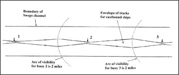
The tracks of a number of ships following a swept channel would, generally, have been contained within the kind of envelope shown in Figure 1. Also, the tendency of ships to pass as close as possible to each buoy meant that collisions with buoys were frequent, so there was often a buoy missing from its station. On the Humber – Elbe Route, that would result in 30 miles between buoys.
Plan of a section of a swept channel through a minefield, showing the envelope of east-bound ship tracks. Buoys (1, 2 and 3) are 5 miles apart. Channel is 2 miles wide. The arc of visibility would apply to both sides of the buoys but, for simplicity, only one side is shown.

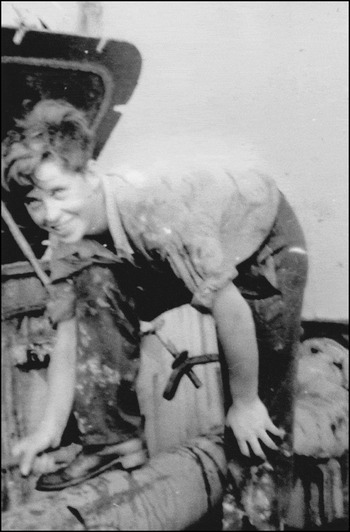
At this stage, I have to record that I came close to knocking out a buoy myself. In those days, cadets (or apprentices) in many companies (including my own) were given very little formal navigational training, spending their time chipping rust off steelwork and repainting it, scrubbing wooden decks, oiling running rigging and such-like tasks (see Figure 2). Our only visits to the bridge were to polish the brass binnacle. So it was a shock, (albeit not an unwelcome one) to find oneself suddenly promoted to uncertificated third mate in charge of a watch and with only a seaman at the wheel for company on the bridge.
Officer training, Eagle Oil style. 1948. John Kemp spent 2½ years of his 4 year apprenticeship becoming intimately acquainted with rusty steel before he was precipitately promoted to uncertificated third officer.

Thus it was that I found myself on the bridge of a tanker following the NEMEDRI Borkum route through the minefields off the north coast of Germany. My youthful over-confidence was supported by almost zero useful experience, but the proximity of unswept mines, and the knowledge that half a million gallons of petrol were slopping around under my feet, concentrated my mind wonderfully.
Having passed a buoy close on my port side, I set course for the next in line but, when I picked it up through the North sea mist, it was well on my starboard bow. This should have been warning enough of the strong, north-going cross tide caused by the big German rivers, Rhine, Ems, Jade and Elbe emptying into the southern North Sea. Quite unconscious of this, I altered course to starboard with the aim of leaving the next buoy a cable or two on my port side. I was leaning nonchalantly over the bridge rail, watching the buoy and it was only as the ship approached it quite closely that I realized how strongly the tidal stream was setting the ship down onto the buoy. I ordered the wheel hard-a-starboard and then, as the bows cleared the buoy, hard-a-port to swing the stern away from the danger.
With great apprehension, I waited for the clang which I fancied would sound the end of my short career at sea. None came, and I resumed an easterly course towards the next buoy, a chastened but wiser young man. But I still wonder why neither the Captain, nor any of the senior officers had thought to whisper a word of advice in my ear at the beginning of my watch. In all conscience, the strong cross currents in the area and the dangers of passing too close to a buoy on the upstream side, were not things I should have been left to find out for myself. It we had struck the buoy, a damaged propeller might have been the least of our worries. The friction of steel-against-steel could have caused enough sparking to send Captain and officers sky-high as well as my inexperienced self. Their reluctance to communicate was something to do with the culture of the time, I suppose.
A general point of interest is to do with collisions on the NEMEDRI routes although, despite my other shortcomings, I do not remember having any near misses with other ships. It is clear from Figure 1 that the envelope of tracks for westbound ships would overlap with the envelope for tracks of eastbound ships. It seems that we were so paranoid about not wandering into the minefields that we kept too assiduously to the centre lines rather than to the starboard sides of the routes as required by the COLREGS. The outcome was that there were more collisions on the NEMEDRI routes than there were contacts with mines. Beattie (Reference Beattie1964) reported three casualties due to ships striking mines in the southern North Sea during the period 1960 t0 1963, compared with over 40 collisions on the NEMEDRI routes during the same period.
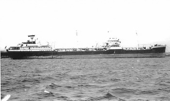
In many ways, it was an exciting time. As a teenager, with no qualifications and almost no useful experience, I happily drove the 16,000 ton tanker San Leopoldo, shown in Figure 3, around the oceans of the world for eight hours a day every day, whereas, ashore, I would not, quite rightly, have been allowed to drive so much as a milk float without a license.
The San Leopoldo was the ship on which John Kemp played hit and miss with the NEMEDRI buoy.

3. PROCEDURES AND PLOTTING – PETER LYON
The topic of coastal navigation, to me, falls into three distinct considerations, namely bridge/watchkeeping routines, position fixing and collision risk assessment, all of which required the honing of particular skills which were largely dormant during long ocean passages. These considerations are discussed below against the background of serving in a major British cargo liner company, the Blue Funnel Line, in the 1950s and 1960s on the Far East and Australian trades.
It was a Company regulation that watchkeepers plotted their positions using coloured pencils according to their rank, with positions plotted whenever possible at fifteen to thirty minute intervals. As a matter of normal procedure, visual and radar bearings were used in conjunction when available with a further check on soundings. The use of opening or clearing bearings was widely adopted when rounding particular areas or points of concern. I cannot recall the use of sextant angles at any time, other than as a navigation exercise for midshipmen. Courses to steer and alter course positions would have been determined previously and marked on the chart by the Second Mate, taking account of minimum passing distances off particular landmarks according to Company requirements as part of what was then regarded as a passage plan. By custom and practice alter course positions were drawn when a given mark was abeam of the course line to aid in positioning accuracy. It was also a Company rule that the Master would have to be called for each alter course position, which resulted in some very sleepless nights.
A further Company regulation (provided there were enough navigating officers, which ceased to be the practice by the late 1960s) was for bridge watches to be doubled up once reaching Ushant for the remainder of the voyage to UK and northwest European ports. The First and Fourth Mates would work watch about with the Second and Third Mates. In the former case the First Mate would feel less than delighted with the prospect of double watchkeeping bearing in mind the very little rest he, particularly, could expect once reaching the many discharge and loading ports and in the latter case the Third Mate would feel aggrieved at having to take a junior role after a period of having a watch on his own for the first time. (Fourth Mates did not have their own watches – they assisted the First Mate). It was the usual practice for the junior officer to undertake the navigation, with the senior taking the collision avoidance role. There were no set procedures or practices for the junior officer to check on or question the actions of his senior and indeed such actions would not have been warmly welcomed. Double watches would also be set at the Master's discretion in other parts of the world where poor visibility and/or heavy traffic was experienced, for example around the Japanese coast. In the case of poor visibility it was common practice for the log entries to show “Slight haze” rather than any reduction in visibility which would have suggested a requirement for speed reduction. (In later years, when tasked with examining log books following collisions or groundings I was of course always suspicious of such log entries).
When arriving for northwest European ports, prior to the traffic separation systems, a sea pilot would be embarked off Brixham or Folkestone depending largely on weather conditions. The Second Mate would therefore have laid the courses up to these points, following which courses to be steered would be recorded in the log as “Various TPA (To Pilot's Advice)”. At other times, when approaching a pilot station or an anchorage, the log would record courses “Various TMO (To Master's Orders)”. In both instances, the watchkeeper responsible for navigation would simply plot the ship position at regular intervals, rarely questioning the pilot or Master regarding his intentions. Similarly, the senior watchkeeper responsible for collision avoidance would simply report on his plotting and occasionally make suggestions to the pilot, although it was always clear that the pilot had the con of the ship. In most cases the pilots were “preferred” or “select” pilots, familiar with the Company's ships and their bridge procedures.
The introduction of radar was generally welcomed and embraced, more so by the junior officers who had the benefit of training in its use and limitations during their studies for the Second Mates Certificate, or who had been sent on radar courses. It seemed to be generally regarded by the Company that senior officers and particularly Masters might view any training to be insulting to their senior status and experience. This disparity could be seen when, in contrast to the usual division of responsibilities during double watches, the First Mate might appoint the Fourth Mate as the radar observer, advising both on position fixing, but not course amendment and on collision detection but not collision avoidance. In other cases, with a single radar providing relative motion only and with the use of paper plotting charts, there could often be conflict in access to the radar, with rank generally being the victor rather perhaps than the operational needs of the moment.
Such practices have in more recent years largely provided the rationale, thankfully, for the development of bridge team management procedures and passage planning techniques which, looking back over the years seem such obvious measures. The development of true motion radar and ARPA, along with electronic position fixing, ship/ship and ship/shore communications and duplication of equipment and displays has provided the watchkeeper with valuable aids, in conjunction with a lot more to command his attention and to oversee. A conclusion from all this however must surely be that ship accidents have diminished, our coastlines are better protected from pollution and that seafaring is a safer occupation?
4. A CONFESSION – PETER LYON
Singapore was astern with Penang ahead and, on this occasion, we would be missing out Port Swettenham. Once clear of Penang we would be clear for the long haul run back to Liverpool. As Third Mate I had relieved the First Mate at 20:00 and settled down for a quiet watch up the Malacca Strait. The First Mate had advised there was a slight easterly set and was steering a few degrees off the set course to maintain the prescribed track. Singapore, as always, had been somewhat hectic in maintaining our loading schedule and a quiet watch with only the Quartermaster on the bridge with me and a lookout forward had all the ingredients of a peaceful break from cargo work and we were, at last, well and truly Homeward Bound. Examination of the chart had shown there would not even be an alter course position to make that would require me, in accordance with bridge Standing Instructions, to call the Captain during the watch.
The sky was overcast, with only a light breeze out on the bridge wing and no discernable swell. No lights could seen ashore and no shipping visible. Position fixing in that section of the Strait was by radar only and in keeping with Company practice I was plotting the position every fifteen minutes with a coloured pencil (Company requirement to be able to identify the watchkeeper at a future date should that be considered necessary). The rough log was written on a slate to be copied into the log without errors or amendment with excursions into the chartroom or the radar hut to be kept to a minimum to ensure a proper lookout. At 21:45 my plot indicated the ship was being set a little further to the east, towards the shoreline some 4 miles distant, so I decided to amend the course to be steered by four degrees to get back on track. I walked through the wheelhouse and gave the order to the Quartermaster “Bring her round to 320 degrees”. The Quartermaster responded and I walked out to the bridge wing to try and get a cooling breeze.
Some ten minutes or so later I felt a little uneasy, but could not think why – perhaps the ship was beginning to respond to a very slight swell. I walked across the bridge and noted the gyro compass heading. My last instruction to the Quartermaster was to steer 320 degrees. The gyro repeater showed 020 degrees.
I can recall, vividly, over forty years after the event, the instant stomach-churning and heart-bursting alarm at my situation, with a quick look at the radar confirming my fears. Instead of the coastline running roughly parallel to the course line, it was now off the starboard bow and closing. The thoughts going through my head were a jumbled conflict between the choices of the correct action to bring the ship back on track and, I regret to say, my concern at being found out and the potential consequences to my career. Should I call the Captain now, as I knew I should have done in accordance with Standing Instructions, or could I remedy the situation without discovery, bearing in mind that the Captain could shortly be expected to come to the bridge to write his Night Orders before retiring for the night?
I decided that the situation was perhaps not as bad as I had originally feared and that the ship could be brought back on track fairly quickly without any severe course alteration that might alert the Captain or indeed the engine room. Gambling on the Captain's practice of writing his Night Orders usually around 22:30, some rapid chart work courtesy of the radar bearings enabled me to bring the ship back on track, followed by quick alterations on the chart to the positions previously plotted, cursing the use of coloured pencils which were more difficult to erase and terrified that I might be caught in the act.
I had just plotted the 22:15 position showing the ship almost on track and by now steering 324 degrees and retreated to the bridge wing with feelings of great relief. I saw the Captain go into the chartroom, where he seemed to spend a very long time examining the chart and writing his Night Orders. He came out to the bridge wing, where I greeted him with the customary “Good evening, Sir”. I told him all had been quiet, with no traffic around and the next alter course position expected to be reached at about 00:50. “Good, tell the Second Mate to let me know when we are on position. Good night Third Mate”. “Good night, Sir”
The above emphasises, if emphasis is needed, the great importance in following the correct procedures, simple and obvious as they are, in communications with the helmsman, particularly when in proximity to a coastline. It also serves as a long hidden confession.
5. THE RUNNING FIX – TOM SELLERS
It is surprising the number of places, with particular reference to the British and near Continental coasts, where many navigational marks sit in solitary splendour, with no other adjacent mark from which to get a bearing and so establish the ship's position. This becomes more exacerbated when visibility begins to deteriorate and the navigator may be left with only one navigational mark to work with. In the days before radar was commonly available, this necessitated the use of the running fix.
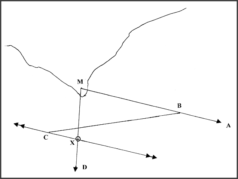
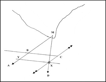
Taking a running fix was relatively simple. A bearing was taken of the single visible navigational mark and laid off on the chart. At some subsequent time, hopefully when the bearing had altered by at least 30°, and better if it had altered by 60°, a second bearing was taken. The log was read at the time of the first bearing and again at the second, and the distance travelled and the course steered was laid off from a point on the first bearing. At the estimated position reached, the first bearing was transferred through this point. The second bearing was laid off, and where the two bearings intersected was the ship's position (see Figure 4). A special case occurred when the first bearing was 45° on the bow, and the second abeam. The distance off the mark was equal to the distance run between the two bearings (see Figure 5).
General running fix. M – Navigational mark; MA – Initial bearing; B – Any suitable point on MA; BC – Course and distance steamed between initial and second bearings. BC may include allowance for tidal set and rate, or leeway, or for both of these effects; C – Point through which the initial bearing MA is transferred; MD – Second bearing; X- Ship's position as determined by running fix.
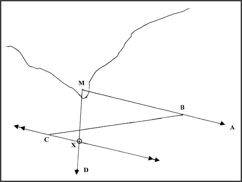
Special case running fix. M – Navigational mark; MA – Initial bearing 45° on port bow; B – Any suitable point on MA; BC – Course and distance steamed between initial and second bearings. BC may include allowance for tidal set and rate, or leeway, or for both of these effects; C – Point through which the initial bearing MA is transferred; MD – Beam bearing; X- Ship's position as determined by running fix. BCXY is a parallelogram so BC=XY. YMX is a right-angled isosceles triangle so MX=XY=BC. i.e. distance off=distance run.

The geometry was perfect. Euclid would have been proud of us. Unfortunately, errors were legion.
Since we are talking of navigation practice in the mid-20th Century, many ships still had only the magnetic compass by which to steer and to take bearings. One of the most important, nay vital, things that an officer could do during his watch was to establish the compass error. This would be entered in the compass error book for future reference. Compass error is made up of two components – variation and deviation. Variation is the angle at the ship's position between the true and magnetic poles. Deviation is the error caused in the compass by the ship's own magnetic field.
Variation is obtained from the chart where, on the compass rose, a variation amount is given for a noted year along with the expected change per annum. A calculation has to be made to determine the amount for the particular year and position in question. Since I do not recall ever seeing a chart correction for variation, one has to hope that the amount of change had not varied by a great deal from that noted when the chart was published. Deviation changes on each course the ship steers and may have altered considerably after a long stay in port, or dry-docking, or with a change in the type of cargo carried.
Thus we have two sources of error inherent in taking the bearings and steering the course between the bearings. At this stage, we might as well remember that during the era under consideration, few ships had automatic steering, and the accuracy of the course steered depended on the skill of the helmsman. Skills varied widely. On this note, the skill of the officer-of-the-watch in taking bearings could also be a source of error, to say nothing of applying the variation and deviation correctly. This produces, at this stage, at least four ways in which errors could be induced.
The next set of errors is tidal direction and speed. Sources of this information are chart, pilot books, or plain eye-balling of buoys if any are in the vicinity. The information on charts and pilot books consists of averages – any tidal direction and speed are usually referred to as so many hours before or after HW at Dover. Again, I do not ever recall seeing a chart correction for tidal streams. Thus the information is, at best, dated. If the tidal rate is small, and direction not very much across the ship's course, most navigators would ignore it. If, on the other hand, the rate is large and the direction well across the ship's heading, it can be allowed for in the run between the bearings. The first bearing can be transferred through the point determined allowing for the tidal rate and set. Thus we have two more sources of error. This would be a good time to consider leeway. Establishing the amount of leeway a ship is making is very much a matter of experience. Probably the longer you have served on a ship, the more accurate will be your estimation, but it has to be emphasized that whatever figure is arrived at, it is solely an estimate. There is little that can be done to enhance its accuracy. Again, it may be allowed for in the course and distance steamed between the bearings.
The final source of error is the ship's towed log, bottom fitted logs being rarely used at this time. On most ships, the same length of line was towed, and some idea of the accuracy of the log could be obtained over time. However, the log clock was mechanical and could be in error. Damage could and did occur to the rotor blades when streaming the log, hauling it, and if it hit something floating in the water. In the mid-20th Century, log repeaters in the chartroom were not common. When the bearings were taken, someone had to dash aft and read it, and then report it to the bridge. Most ships used a system of whistle signals (not the ship's siren) to summon the stand-by man, wherever he might be. One whistle meant that he was needed on the bridge, two whistles meant read the log and three whistles bring up some tea. There was always an interval between taking the bearing and the man reading the log. In addition, it could only be read to an accuracy of tenths of a mile. Thus, other sources of error were introduced in the distance laid off between the bearings. On more than one occasion the stand-by man, whenever he missed the correct number of whistle signals, turned up on the bridge without the reading and had to be sent back, or even on one occasion I experienced, arriving with a cup of tea.
I believe I have enumerated some seven sources of error due to instruments and information, and probably seven more due to personal error, either by the officer-of-the-watch, the wheelman or the stand-by man. So how accurate was a running fix? Was it worth taking? The answer to the second question is yes, it was well worthwhile. It kept the officer-of-the-watch alert and, if nothing else, as prompted by the COLREGS, if the bearing of the mark was changing, you were unlikely to run into it.
The first ship on which I was a watch keeper was running from the UK to the Baltic – mainly to Finland, so that there was plenty of opportunity for coastal navigation. During my time on this ship, it acquired a radar. Being an eager-beaver Third Mate, I continued to take running fixes, and of course was able to check their accuracy by radar. (This was partially prompted by the radar not being particularly reliable, breaking down regularly – mainly when it was needed most). I regret that I did not keep any record of the difference between the running fixes and the radar fixes, but my memory is that the difference in distance off the navigational mark was somewhere between ½ mile and 2 miles, the greater error usually occurring when navigating further offshore with a longer time on the run between the bearings.
In conclusion, I would mention that the running fix was also used in celestial navigation. We all remember getting a Sun sight around 0900 and a meridian or ex-meridian around noon. Once again only one navigational mark was available – the Sun. We laid off the course and distance between the sights, transferred the 0900 position line through this estimated position (which was probably also used for working out the noon sight) and a fix was established where the position lines intersected.
The running fix, whether we liked it or not, and despite all the possible errors, was a most necessary means of establishing the ship's position.
6. RADIO DIRECTION FINDING (RDF) COULD BE USEFUL – TOM SELLERS
In general I would very much agree with John Kemp's (section 1) and Søren Thirslund's (section 8) comments about RDF bearings. However, in one particular recurring situation, I found them to be most useful. Our faster ships made the North Atlantic crossing from the Strait of Belle Isle to Inishtrahull in about 4½ days. On more than a few occasions this passage was made without any sight of Sun or stars. As luck, or ill-luck would have it, our first port of call was Liverpool and we would be due there for a late p.m. tide on Saturday or an early a.m. tide on Sunday. Orders for tugs, linesmen and stevedoring gangs for the weekend had to be given before noon on the previous Friday. Thus, when well west of Ireland and with no reliable position, I had to advise the Company whether or not to make the arrangements for arrival. If they were made and the ship did not make the tide, the Company lost a lot of money and I was unpopular. If no arrangements were made and the ship could have made the tide, I was also unpopular. The 100 fathom line to the west of Ireland runs in a more or less North/South direction. The RDF station on the Mull of Kintyre bears more or less due East. This gave a good right-angled cut, so I used to get a RDF bearing as we crossed the 100 fathom line. It always proved to be sufficiently accurate to enable a definite ETA to be given.
7. CLOSE INSHORE – MIKE BECHLEY
Much of my coastal navigation in the 1960s and early 1970s was simply the BoT examinations put into practice. On my first year going between Japan and the Gulf on MV Chanda (British India Steam Navigation Co Ltd, built 1942) the Master did not really trust the radar (probably also because the power source was a very noisy converter over the bunk in his cabin). The watchkeepers had to use such tried and tested methods as rising and dipping of lights, doubling the angle on the bow and so on. This worked reasonably well until the shamal struck, and the radar had to be used. For my second year on the same service, in SS Nuddea (built 1956), we had the luxury of Decca Navigator in parts of the Gulf and the Japanese coast. Decca was rarely of much use at either end, due to atmospherics ruining reception for much of the time in the former, and comparatively limited coverage in the latter. Radar had, however, improved somewhat, and a slightly more trusting Master allowed it to be used as we wished. As the Japanese coast was well lit, we generally preferred to use what we could see, rather than what we couldn't. This was the period long before the spread of VTS and TSS and every ship seemed to go wherever they wanted – and in the case of coastal fishing vessels all the way along the route, they always did and with very poor lights as well.
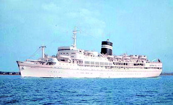
From 1968 to 1976, I was on passenger vessels – BI's Uganda (Figure 6) and Nevasa, and P & O's Oriana. The former always stayed in European waters, with two exceptions. Our coastal navigation became highly competent, as the Masters would leave us to it, except when steaming in very close to land, to show off particular features. One Captain on Nevasa took particular delight in this – perhaps 1 cable off Cape St Vincent, using the inner passage round Ushant, half a mile off Trafalgar and so on. Once we had ‘shown off’ he would vanish. There was rarely any thought of passage plans (other than a cursory glance at the tidal stream) and the like, as everything was done by eye – and years of experience on his part. Decca was still not entirely trusted – rightly so, and visual bearings would always take priority if at all possible. Fog brought Decca and radar into their own for position finding, especially when we cruised in the Baltic. On these cruises, the chart would inevitably be brought out from the chartroom and rested on a small table in the wheelhouse normally used for coffee. In BI the standard interval between fixes was normally 30 minutes, but reduced to 15 minutes when close in – say less than 3 miles offshore. I can't remember ever having to put positions on the chart at less than 15 minute intervals, but I would guess that we did for the short intervals when rock-hopping around Cape St Vincent. Most Masters insisted on using three bearings if this was at all possible, or two bearings and a range back-up, with further reference to the echo sounder in shallow water (less than 40 fathoms or so), so that there were generally three lines of position on the chart. Ranges from the mid-60s radar were not always exact – we were taught that range rings were more accurate than the range marker, and this proved to be correct.
BI's SS Uganda.

Only in Chinese waters were lights unreliable. To go to Shanghai – tidal river, poor visibility, buoys which did not correspond with the chart, very uncommunicative pilots (this was the age of the Cultural Revolution) with everything electronic switched off was weird in the extreme. We were not allowed to use anything, even when alongside. There was a story that a Second Officer on a Blue Funnel vessel was jailed for a while because he switched on the echo sounder, but we never found out if this was true. Only experience gained over the years by Chief Officers and Masters could allow them to relax more than a first-year Third Officer!
My first voyage to the Norwegian fjords introduced me to sectored lights. These were so easy and simple to use that I wondered for years why nobody else used the principle to any great extent. We basically depended on the pilot's advice and stayed in the white sectors – the trick was to alter course at the right point before going round a blind corner with perhaps 1000 ft of very solid rock in front of you! This was probably the one subject which was only summarily covered in the BoT syllabus.
The advent of TSS made life much easier. Most of the ships would be going on nearly parallel or reciprocal courses so it was much easier to keep on the planned track, but even so, being just a couple of weeks out on Admiralty Notices to Mariners in those days meant that each voyage would usually provide something which ‘wasn't on the chart’. Navigational aids improved in their reliability and capability. This did not necessarily mean that the watchkeepers' lives became any easier, as GPS was still but a dream for most vessels. Lights and buoys were reliable as the vast majority were manned and routinely inspected (not that they aren't now around Europe).
Only when I left Oriana in early 1976 did we have satellite navigation – a huge computer in the chartroom (which was air-conditioned) and which had to print out its calculations once a day for verification – reams of paper involved. We only found out that air-conditioning was necessary half way between San Francisco and Honolulu when the machine ‘died’ on us. A technician arrived in Hawaii took one look at the temperature and made a remark about goddam instruction books, “Keep the goddam door shut and the a/c on and it will be OK.” He was right.
My tuition was from BI's Cadet Instructor Officers, and then by correspondence course (distance learning) from Sir John Cass College, plus Nicholls's Concise Guide, and later on, the Kemp and Young books. The grounding I had in principles and practical navigation was good enough for me never to be knowingly lost – although we must have got close in the south-west monsoon on the Indian Coast, and in snow around Japan. The echo sounder was invaluable as a back-up in the Gulf – even the flashing-light type so beloved of Marconi radio officers. The sextant was still of use in coastal navigation – vertical sextant angles and Lecky's Wrinkles and Vertical Angles were still part of the furniture and the bridge library.
For statistical purposes, BI never used to bother about the actual minute to ring full away. It came as a surprise when the fleets merged and I went to Oriana to find that SBE (stand by engines) and ROE (ring off engines) had to be at xx06, xx12 and so on – single decimal points of 1 hour – allegedly to make life easier for the Chief Engineer to do his statistics. This could be tricky when approaching some ports at full speed, so inevitably I used to slow down slightly earlier than perhaps I ought to have done, just to keep the sums easy!
8. A DANISH PERSPECTIVE – SØREN THIRSLUND
The mid-20th century was interesting navigation-wise. During World War II, some revolutionary new inventions helped to make all navigation simpler and more exact although radar, for example, needed further development and was only slowly adopted by merchant shipping. I started as a seaman in 1935, and graduated to AB in 1940. I obtained my tickets as mate, master and radio operator between 1941 and 1944. My experience in coastal navigation before studying was only what I could learn by observing what officers were doing while I was steering the ship. This was before the autopilot became common.
My first job as mate was in the summer of 1944 and, at that time, only navigation in the Baltic sea was possible because Denmark was occupied by the Germans. In a way, coastal navigation was quite simple. Due to the danger of magnetic and other mines, it was compulsory to follow special swept routes. In shallow waters, these were marked by light vessels and buoys, most of which were fitted with a light and with sound by bell or whistle, making it possible to navigate 24 hours a day, and even in fog. The lights were quite weak, however and, during air raids, the light vessels extinguished their lights.
To follow a route in clear weather was quite easy, as the distance between the marks was mostly so short that, when passing one mark, the next one could be seen. Also, as noted in section 2, all buoys were to be kept on your port side so that other ships would generally pass port to port. Naturally, it was necessary to keep an eye on the tidal streams, as in spring tides the current could be so strong that the buoys were drawn down and could not be seen. In low visibility, it was a problem to see the buoys and it was a great help to have a good man as lookout. If in doubt, it was the rule to drop anchor until the weather cleared.
At that time, much navigation was in convoys which, in clear weather, made it quite easy to follow the line by watching the ship in front. Only a few Danish ships were fitted with a gyro-compass, so it was important to keep an eye on the compass error. This was especially necessary after Danish and other Baltic waters had been scattered with magnetic mines. The vessels then had to be demagnetised and, even after compensation, compasses were quite unsteady.
To some foreign navigators, Danish waters were considered quite difficult and, when they came to The Skaw, they hired a pilot who would take them all the way to their destination. There were also pilots available at all ports in Denmark. They usually cruised outside their harbours.
For many years after the war, it was still compulsory to follow the swept routes (see also John Kemp's contribution in section 2) but, after the routes were declared mine-free, we could begin to navigate without restriction. The old fashioned methods for coastal navigation were then taken up again. It was normal practice to consult a chart and select a route so that you could pass safely from point to point. The Master usually decided what distance off points, islands and reefs should be taken and then the mates plotted the courses.
It was standard practice, during a watch, to fix a vessel's position by cross bearings or by four and eight point bearings which gave the distance off a point (see also Tom Sellers' contribution in section 5). Radio bearings were also used, but many older masters were reluctant to accept the value of this instrument and “these new ideas”. Once I had a chance to make an old shipmaster see it work. We had loaded timber in the northern Baltic and, on our way south, we had dense fog. I suggested we should head along the radio bearing of a lightship so that, when we heard its sound signal, we would know where we were. He agreed, and he was satisfied.
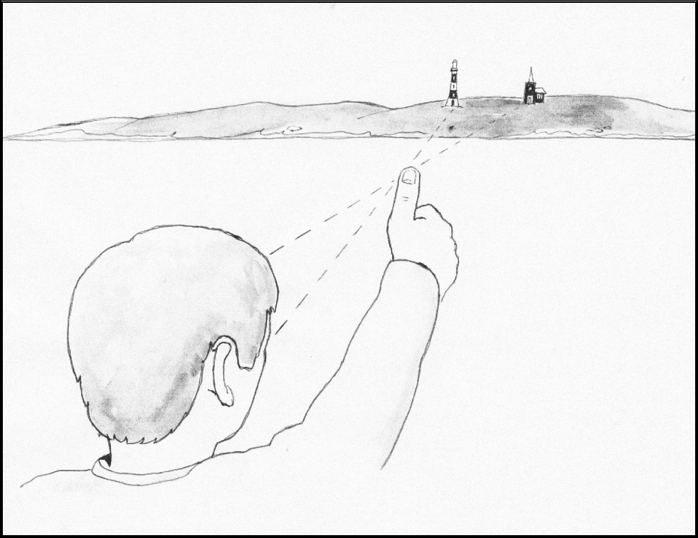
Before radar and other electronic devices became commonplace, some funny ideas were used to keep a vessel on track. One I like is to find the distance off an island of known width or off some points ashore, the distance between which can be found from the chart. The procedure is to sight over your thumb on an outstretched arm as shown in Figure 7.
Distance by rule of thumb.
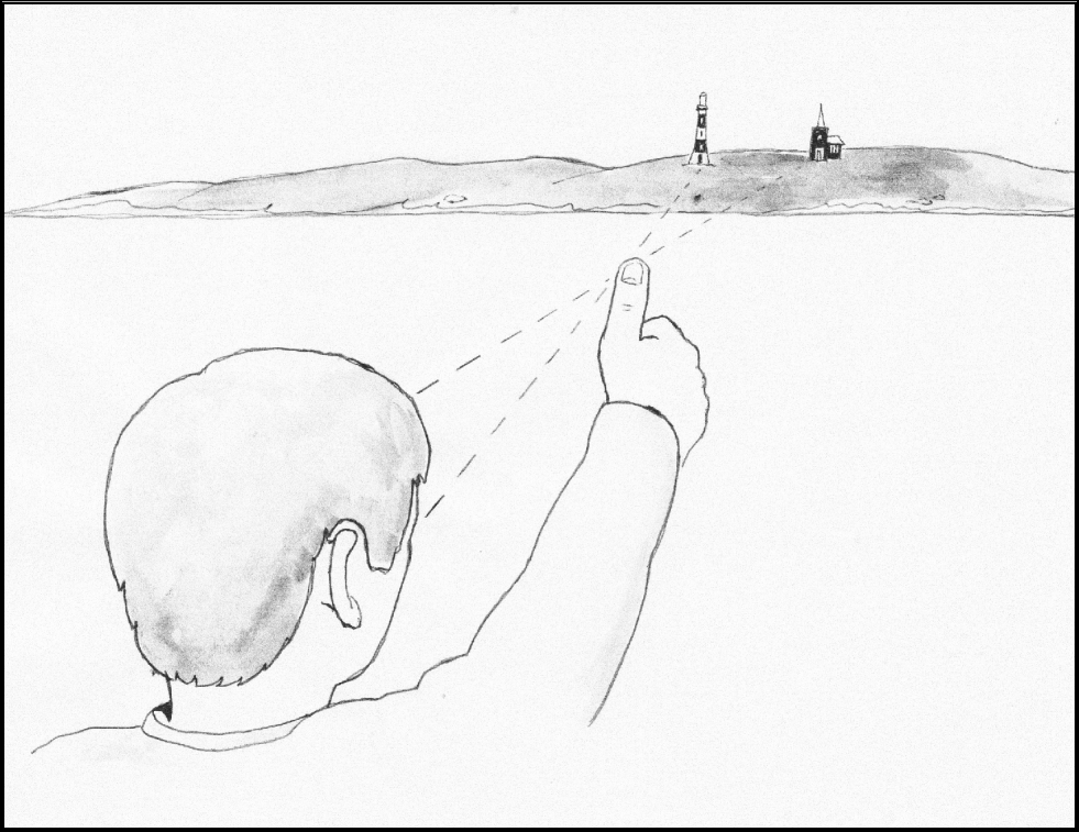
When you close one eye at a time, it will look as if the thumb is moving across a horizontal distance ashore. If you can measure this distance on a chart, you now have two similar triangles. The smaller triangle consists of the distance between your eyes and the two lines from the eyes to the thumb. The larger triangle consists of the two lines from your thumb to the ends of the horizontal distance measured on the chart. The distance between your pupils can be taken as 68 millimetres, and the distance from the eyes to the thumb as 68 centimetres, in other words a ratio of 1 to 10. Proportionally, the large triangle has the same ratio, so the distance to the shore is the distance across the island or between the chosen points multiplied by ten. I often tested this procedure after radar had become common, and it is amazingly accurate.
The teaching of coastal navigation in Denmark was divided into three categories, the yacht skipper, the coastal skipper and the navigator, covering all navigation. Initial training was mainly by working on charts covering Danish waters. A departure port and a destination were given and the student was told the deviation and the leeway. The variation was marked on the chart. Then the student plotted the course on the chart and calculated the appropriate compass course and distance for each leg.
In practice, a new mate was tested when he started onboard ship, and he was not left alone on watch until he had proved to be able to navigate with safety and to follow the international rules of the road (COLREGS). After leaving port, the log was streamed and, in ships running the same voyages all the time, like ferries, the engine revolutions were used to tell distances.
In foggy weather, the echo-sounder or lead and line were used, and the depth of water could be used for position finding by comparing the depth and the condition of the bottom with the chart. The lead was ”armed” with some wax or tallow to bring up samples from the bottom. When possible, radio bearings were used. Astronomical observations were used only for determining the compass error or by young officers to see how close their astro fixes were to the correct position.
9. A GREENLAND EXPERIENCE – SØREN THIRSLUND
I would like to add my experience from my voyages to Greenland. Coastal navigation in that area was quite difficult as the charts were not brought up to date until about the 1950s, during which decade Decca chains were also established. Before that time, the charts available were from the mid-19th Century. Also the magnetic variation was high and, because of the large angle of dip, the horizontal component of the Earth's magnetic field was small. The magnetic compasses were therefore quite unstable. There were a few radio beacons, but they were placed at some distance from the coast, so one could not expect them to be exact. To obtain some useful bearings we often used the common radio stations for direction finding.
In 1948, I was the second mate and wireless operator of an old steamer. We had loaded 2,000 tons of coal in England for Godthaab (now called Nuuk). After a fair voyage, we were close to our destination, but then we had dense fog and had to stop. I had radio contact with the Danish Navy ship Thetis. I could hear from the signal that she could not be too far away from us. I had one radio bearing of Godthaab and, being a Navy ship, I was sure that the Thetis was fitted with radar and knew her exact position. I asked her for her position and to give us a signal so we could get a bearing. The reply took some time, and then he came back and told me that the Navy's positions and movements were secret. My captain just shook his head.
When the fog lifted, we found Godthaab and were moored with both anchors on 60 fathoms of cable and with four ropes aft. We started unloading but, one day, a gale came up and the harbour master advised us to stop discharging and to slacken our after ropes. Then the Thetis came up. He dropped his port anchor with only 45 fathoms of cable, and wanted to make fast alongside us, but our old captain told him he would have to go forward, lift his anchor and drop it again with at least 60 fathoms of cable on it. He did so, but when he had tied up alongside us, our captain shouted, “Is this what you call secret movements?” Anyhow, we became very good friends with the officers, who showed us around their ship and, for the first time, I had the opportunity to see a working radar.
The area around Cape Farewell is quite dangerous with storms and large icebergs and, after some smaller ships had been lost with loss of life, it became compulsory for all ships in the area to report positions, ice observed and weather conditions to the Navy station at Grønnedal. In the 1960s, I was back in the Greenland trade on tankers, but then we all had radars, echo sounders and even defrosted front windows in the wheel-house, so navigation was easier.
10. CONCLUDING REMARKS – JOHN KEMP
The accounts included in this collection cover mostly the period from the 1940s to the end of the 1960s. In the early years, there was little in the way of electronic navigation aids apart from the sadly, and perhaps unjustly, distrusted radio direction finding (RDF) installation. As the various contributions show, radar was similarly distrusted in the 1950s, when it first began to be widely fitted in merchant ships, and it was not until the 1960s, and the introduction of radar observer courses that people became proficient and confident in its use. Before that time, our position fixing was based mainly on landmarks, sea marks, lights and astronomical bodies. Things we could see – and in poor visibility we couldn't see much at all.
The other thing that comes out of the accounts is the autocratic chain of authority that prevailed at that time. Decisions tended to be made by individuals without reference to other members of what could only loosely be termed the navigation team. When making a decision, we were reluctant to consult a person on the next rung down the ladder because they would clearly not be competent to provide advice. And we would be equally reluctant to consult a person on the next rung up the ladder in case it made them think that we might be incompetent.
As Peter Lyon points out, this state of affairs has completely changed so that bridge team management procedures and passage planning techniques are now the norm. These procedural changes probably contribute to the reduced casualty rate at sea as much as the introduction of traffic separation schemes and improvements in navigational aids and instruments.
But, of course, we still think that young chaps at sea these days don't know the half of it.