

Bedrock mortars are a recurrent phenomenon worldwide, generally associated with hunter-gatherer groups (e.g., Babot Reference Babot2006; Bednarik Reference Bednarik2008; David Reference David1998; Latcham Reference Latcham1929; Menghin Reference Menghin1957). Nevertheless, bedrock mortars have received scant attention in the archaeological literature, which has focused mainly on formal and technological characterizations, and to a lesser degree, on residue studies (Rosenberg and Nadel Reference Rosenberg and Nadel2017). This scant attention contrasts with the recognized relationship between this record and the grinding of plant resources, and thus with the economic and social dynamics of human groups.
In the southern cone of South America, some bedrock mortars have been recognized for the Inka period (Giovannetti Reference Giovannetti, Austral and Tamagnini2008), but the majority of studies refer to hunter-gatherers, concentrating on formal and chronological characterization (e.g., Gajardo-Tobar Reference Gajardo-Tobar1958–1959; Niemeyer Reference Niemeyer1958; Methfessel and Methsfessel Reference Methfessel and Methfessel1998), and to a lesser extent on identifying the ground products and how they fit into the productive aspects of ancient societies (e.g., Babot Reference Babot2004, Reference Babot2006; Belmar and Carrasco Reference Belmar, Carrasco, Belmar, Contreras and Reyes2017; Planella et al. Reference Planella, Santander, Mcrostie, Rojas-Mora and Belmar2018). Some researchers have stressed the importance of bedrock mortars in these populations’ constitution of the social and spatial relations beyond mere economics, especially during moments of transition to agriculture (e.g., Babot Reference Babot, Nielsen, Rivolta, Seldes, Vázquez and Mercolli2007a; Giovannetti Reference Giovannetti2015; Pastor Reference Pastor, Nilsen, Rivolta, Seldes, Vásquez and Mercolli2007, Reference Pastor and Salazar2015; Pino Reference Pino2014; Troncoso et al. Reference Troncoso, Pino, Belmar, Belmar, Contreras and Reyes2017).
Bedrock mortars are a recurrence in the archaeological record in the semiarid north of Chile (SAN), especially between 30° and 31°S. They have been ascribed to the Late Archaic period (ca. 2000 BC–AD 1) due to their spatial association with Late Archaic shell middens (Schiappacasse and Niemeyer Reference Schiappacasse and Niemeyer1965–1966). Their appearance is thought to coincide with the transformation of the hunter-gatherer communities of the region, which during the Late Archaic switched from a maritime-based economy to one based more on plant resources, culminating in the appearance of pottery and the adoption of a sedentary, agricultural way of life during the Early Ceramic period (ECP; AD 1–1000; Schiappacasse and Niemeyer Reference Schiappacasse and Niemeyer1964, Reference Schiappacasse and Niemeyer1965–1966).
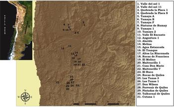
Notwithstanding the importance of these proposals, more recent research has reassessed the ECP in the region, recognizing that despite the appearance of pottery, a mobile life was maintained, and settled communities reliant on agriculture did not appear until the Late Intermediate Period (AD 1000–1450; Méndez et al. Reference Méndez, Andrés Troncoso and Jackson2009; Troncoso et al. Reference Troncoso, Vergara, Pavlovic, González, Pino, Larach, Escudero, La Mura, Moya, Pérez, Gutiérrez, Pascual, Belmar, Basile, López, Dávila, Vásquez and Urzúa2016). It is therefore necessary to reassess both the chronology of bedrock mortars and the ways in which they articulated social processes of hunter-gatherers during the late Holocene in the SAN. In the present work, therefore, we study bedrock mortars from a regional viewpoint, combining formal and spatial analysis based on systematic excavations, analysis of microfossils, and absolute dating from the Limarí River basin (30°S; Figure 1). We then discuss the historical development of bedrock mortars among hunter-gatherer groups of the region, how they related to their economic practices, and how production intensification was associated with the increasing relevance of grinding in the constitution of social relations between these groups. Our analysis integrates the different levels of variation in bedrock mortars, an approach which might be useful in studies in other regions.
Sites with bedrock mortars in the Limarí River basin (Map by Andrés Troncoso). (Color online)

The Study Area and its Bedrock Mortars
The Limarí River basin (30°S) lies in the central sector of the SAN, a transition region between the Atacama Desert and the mediterranean valleys of central Chile. It is oriented east-west and consists of several snow-fed watercourses, principally the Hurtado, Rapel and Grande rivers which meet near the town of Ovalle to form the Limarí River. The basin contains two large-scale formations. The first is mountainous and is associated with narrow east-west river valleys, hemmed in by spurs of the Andes Mountains that rise to heights of 3,000 to 5,000 m asl. These valleys are drained by tributary ravines with seasonal waterflow dependent on rain and snow precipitation. The second is coastal and is characterized by a more open landscape. The narrow valleys of the mountains give way to coastal mesetas that are not well suited for crops; only the fluvial terraces associated with the Limarí River and other, smaller streams are farmed. The coastal mesetas are intersected by small ravines that run down to the coastline.
Human inhabitation of the basin has been intense from an early date, with evidence going back to the early Holocene (Troncoso et al. Reference Troncoso, Vergara, Pavlovic, González, Pino, Larach, Escudero, La Mura, Moya, Pérez, Gutiérrez, Pascual, Belmar, Basile, López, Dávila, Vásquez and Urzúa2016). Bedrock mortars are ubiquitous, and their distribution is concentrated in the central sector of the SAN (Limarí and Elqui basins; Niemeyer Reference Niemeyer1960). In the Limarí basin, they are mainly reported in littoral contexts and coastal valleys (Iribarren Reference Iribarren1956), although a few examples are known further inland in the Elqui valley (Iribarren Reference Iribarren1962).
Despite the wide distribution of bedrock mortars, there are few studies of them in this region, which mainly concentrate on chronological issues based on spatial associations. Schiappacasse and Niemeyer (Reference Schiappacasse and Niemeyer1964) ascribed the bedrock mortars at the shell midden of Guanaqueros to the Archaic IV period (around 3500 years BP, which today we call the Late Archaic), but without discounting the possibility that they may date from the ECP. At the same time, based on the results of the excavations carried out in the middle basin of the Elqui River, Iribarren (Reference Iribarren1962) proposed that the bedrock mortars were associated with the El Molle Cultural Complex, a group from the ECP. Ampuero and Rivera (Reference Ampuero and Rivera1971a), in their works on Valle El Encanto, developed a systematic record of the bedrock mortars based on the shape of the ground depressions (ellipsoid, cupuliform, and rectangular) but proposed no specific period for any of them. Ampuero (Reference Ampuero1992) subsequently suggested a possible link with the El Molle Cultural Complex.
When attempting to interpret bedrock mortars, most authors recognize their association with grinding grains and other elements (Ampuero and Rivera Reference Ampuero and Rivera1971a; Schiappacasse and Niemeyer Reference Schiappacasse and Niemeyer1964, Reference Schiappacasse and Niemeyer1965–1966). Ampuero and Rivera (Reference Ampuero and Rivera1971a) add to this hypothesis a possible ritual function due to the spatial relationship with rock art at the Valle El Encanto site. In this context, the strongest interpretation of bedrock mortars is by Schiappacasse and Niemeyer (Reference Schiappacasse and Niemeyer1964), who consider the mortars' appearance and proliferation to be indicators of transformation from a marine to a more diversified economy during the Late Archaic, with strong emphasis on plant resource collection and exploitation (Schiappacasse and Niemeyer Reference Schiappacasse and Niemeyer1964, Reference Schiappacasse and Niemeyer1986). The authors tentatively suggest exploring the idea of a “loss of the importance of a hunting economy in favor of other food sources, including crop production on a limited scale” [Schiappacasse and Niemeyer Reference Schiappacasse and Niemeyer1964:260; our translation]. Appearance of bedrock mortars would have been accompanied by a series of other changes observed in the archaeological record of the Late Archaic, such as the appearance of large cemeteries and rock art (Quevedo Reference Quevedo1998; Schiappacasse and Niemeyer Reference Schiappacasse and Niemeyer1964, Reference Schiappacasse and Niemeyer1986; Troncoso et al. Reference Troncoso, Vergara, Pavlovic, González, Pino, Larach, Escudero, La Mura, Moya, Pérez, Gutiérrez, Pascual, Belmar, Basile, López, Dávila, Vásquez and Urzúa2016), which would be a prelude to the later introduction of agriculture and a sedentary way of life in this region during the ECP (Ampuero Reference Ampuero2010; Niemeyer et al. Reference Niemeyer, Castillo, Cervellino, Hidalgo, Schiappacasse, Niemeyer, Aldunate and Solimano1989; Schiappacasse and Niemeyer Reference Schiappacasse and Niemeyer1986).
These proposals have been reassessed during the last decade. On the one hand, studies of settlement and mobility patterns show significant continuities between the Late Archaic and the ECP (Méndez et al. Reference Méndez, Andrés Troncoso and Jackson2009; Troncoso et al. Reference Troncoso, Vergara, Pavlovic, González, Pino, Larach, Escudero, La Mura, Moya, Pérez, Gutiérrez, Pascual, Belmar, Basile, López, Dávila, Vásquez and Urzúa2016). The appearance of pottery in this context would not have caused a break in pre existing spatial dynamics. In fact, ECP groups had a relatively small quantity of pottery, characterized by pieces of relatively small size and mechanical strength, suitable for a mobile way of life. On the other hand, isotopic studies of ECP skeletons show a reliance on C3 resources; an increase in consumption of C4 plants—in this case maize—is only observed in the Late Intermediate Period (Alfonso et al. Reference Alfonso, Andrés Troncoso, Larach and Becker2017). At this time a change also occurs in settlement patterns, accompanied by increased popularity of pottery, which is consistent with a sedentary, agricultural way of life (Troncoso et al. Reference Troncoso, Vergara, Pavlovic, González, Pino, Larach, Escudero, La Mura, Moya, Pérez, Gutiérrez, Pascual, Belmar, Basile, López, Dávila, Vásquez and Urzúa2016). At the same time, isotopic evidence indicates a reduction in the consumption of animal protein and an increase in plant resources during the ECP (Gómez and Pacheco Reference Gómez and Pacheco2016), and this is corroborated by the archaeological record, in which a drastic reduction of zooarchaeological remains is observed. In this context, the chronology of bedrock mortars and their relationship with social processes involving the use of plant resources in the region and the dynamics of hunter-gatherer groups in the late Holocene must be reassessed.
Materials and Methods
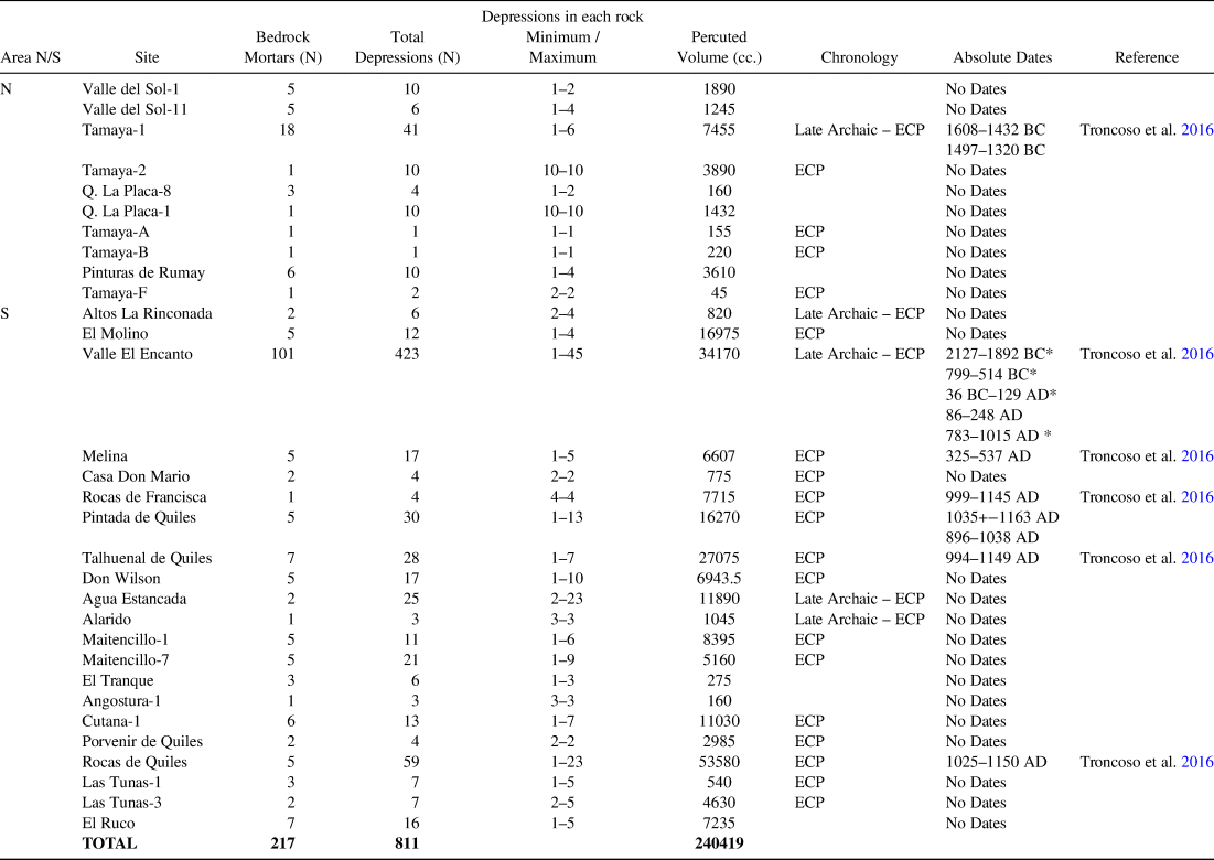
Our systematic surveys in the Limarí basin have covered an area of 120 km2, including different types of topography, geoforms, and altitude floors (Troncoso et al. Reference Troncoso, Vergara, Pavlovic, González, Pino, Larach, Escudero, La Mura, Moya, Pérez, Gutiérrez, Pascual, Belmar, Basile, López, Dávila, Vásquez and Urzúa2016). We have recorded 31 archaeological sites with bedrock mortars (Figure 1), comprising 217 rock supports and 811 depressions (Table 1; see also Supplemental Table 1 that includes more detailed information). As we have indicated in another work (Troncoso et al. Reference Troncoso, Pino, Belmar, Belmar, Contreras and Reyes2017), we have taken a multiscale approach to bedrock mortars, with an integrated recording strategy that combines formal, spatial, and productive dimensions.
General Features of the Limarí River Basin Bedrock Mortars.

*Data obtained from excavation units not close to any bedrock mortar.
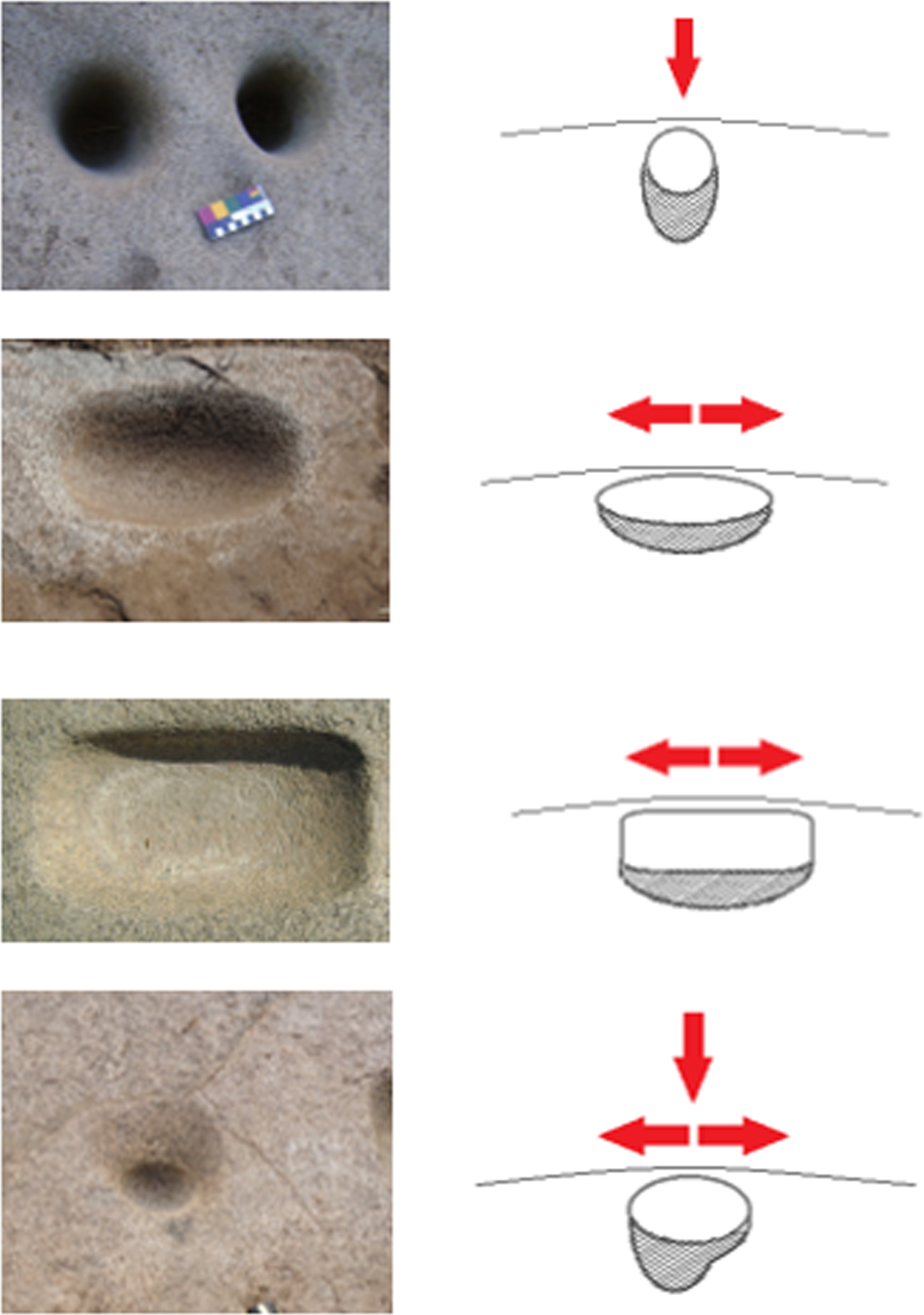
We first made a formal description of the supports (the bedrock) and the depressions (mortars). In the case of the bedrock, we considered their dimensions and the type of rock, and counted the number of depressions. We considered the shape and dimensions of the depressions following Babot (Reference Babot2004), and ascribed each to one of the types proposed by Ampuero and Rivera (Reference Ampuero and Rivera1971a)—cupuliform, rectangular, and ellipsoid—and we added a fourth category, mixed, to cover those that present an oval-circular mouth, frequently with polished surface and a section tending to the elliptical, which combines cupuliform and ellipsoid manufacturing techniques (Figure 2). We paid special attention to stratigraphic relations with other mortars (superimpositions), which are valuable temporal indicators (Pino Reference Pino2014).
Types of mortars: a) cupuliform, b) ellipsoid, c) rectangular, and d) mixed (Illustrations by Mariela Pino). (Color online)

For each rock we calculated the volume of stone ground out per depression, allowing us to estimate the work involved in production. For this, we adapted the methodology used for measuring ceramic vessels, which consists of filling the depression and then transferring the contents into a measuring cup (Pino Reference Pino2014; Troncoso et al. Reference Troncoso, Pino, Belmar, Belmar, Contreras and Reyes2017).
We sampled 98 depressions at 10 sites to carry out a microfossil study of use residues, applying a multiple microfossil analysis, which involves recovering and studying all the microfossils of a sample (Coil et al. Reference Coil, Korstanje, Archer and Harstof2003). The most appropriate method for extracting microfossil samples in this case was direct scraping (Loy Reference Loy and Hather1994). A similar technique was used on some active grinding implements, which were recovered in the excavations and the areas surrounding the bedrocks. We also obtained control samples from uncleaned surfaces to determine the natural contamination of the sites. We took the precaution of using a protocol that would reduce the possibility of contamination and degradation of the samples while they were being obtained and prepared (Belmar et al. Reference Belmar, Quiroz, Niemeyer, Planella, Albornoz, Meneses, Alfaro, Carrasco, Collao-Alvarado and Echeverría2014), such as using synthetic fibers for cleaning the laboratory implements.
The samples were observed under a petrographic microscope with magnification of 200x and 400x. To describe the morphology and attributes of the microfossils, we used the International Code for Phytolith Nomenclature 1.0 (Madella et al. Reference Madella, Alexandre and Ball2005), International Code for Starch Nomenclature ([ICSN] 2011), and Franceschi and Horner's (Reference Franceschi and Horner1980) description of crystals. We consulted some reference collections (Albornoz Reference Albornoz, Belmar and Lema2015; Gili et al. Reference Gili, Albornoz, Javier, Magdalena, Carrasco, Meneses and Niemeyer2016; Giovannetti et al. Reference Giovannetti, Austral and Tamagnini2008; Korstanje and Babot Reference Korstanje, Babot, Madella and Zurro2007; Patterer Reference Patterer2014). All microfossils were measured and recorded photographically. We also made a reference collection of some local taxa, such as Acacia visco Lorentz ex Griseb, Jubaea chilensis (Molina) Baill, and Prosopis chilensis (Mol.) Stunz, following the protocol for direct extraction of elements (Babot Reference Babot, Marconetto, Oliszewski and Babot2007b).
Finally, we carried out excavations immediately around the bedrock blocks. Samples obtained from these excavations were radiocarbon dated. The absolute dates obtained were calibrated using the Oxcal 4.2 program (Bronk Ramsey Reference Bronk Ramsey2009) and the ShCal3 curve, considering a 95.4% confidence level (2 δ; Hogg et al. Reference Hogg, Hua, Blackwell, Niu, Buck, Guilderson, Heaton, Palmer, Reimer, Reimer, Turney and Zimmerman2013). All the data obtained were integrated at site and regional scale to inform the discussion of our research problem.
Results
Before we present our results, we must stress that the study sample shows that the Valle El Encanto (VEE) site is a particular record that stands apart from regional trends. Not only does the site have a large number of bedrock mortars, but it is also a rich repository of rock art—paintings and carvings—associated with hunter-gatherers and farming communities of the late Holocene, and it presents an important stratigraphic occupation by hunter-gatherer groups. Based on the high intensity of the manufacture of bedrock mortars and rock paintings, and the exceptional nature of the motifs of the paintings, we have come to understand this as an aggregation site (Troncoso et al. Reference Troncoso, Pino, Belmar, Belmar, Contreras and Reyes2017). For this reason, the results will be assessed both including and excluding this site in the analysis, for greater clarity and explanatory value.
Shape Variations
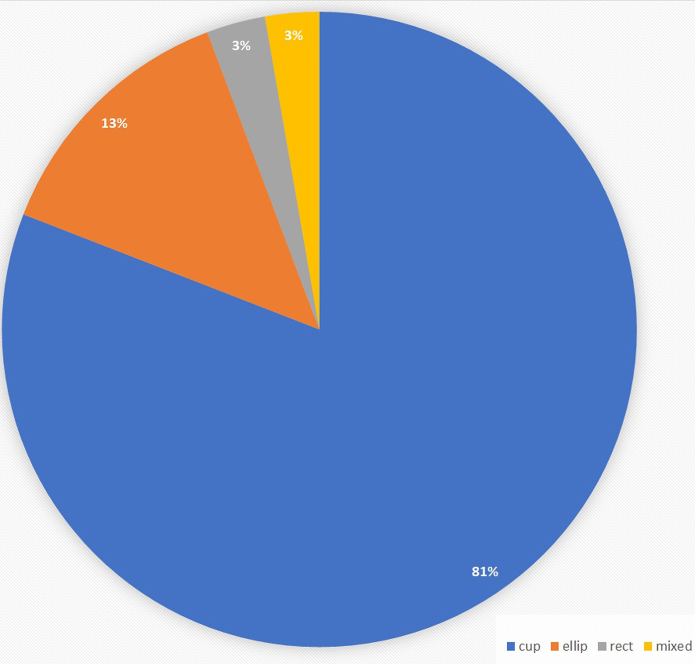
The most recurrent shape of depressions in the region is cupuliform (81%), followed by ellipsoid (13%), and rectangular and mixed (3%; Figure 3). No particular intrasite distribution is observed of the two less-frequent types of mortar, which coexist with cupuliform examples.
Regional distribution of the types of mortars. (Color online)

As Table 1 shows, the number of bedrock mortars varies between 1 and 101 blocks per site (mean = 6.9 blocks). Nevertheless, the great majority of sites (93.75%) had fewer than 10 blocks, most frequently between 1 and 5. As mentioned above, VEE is an exceptional site, with five times as many blocks as the site with the next largest number (Table 1). If we eliminate this site from the calculation, we see that the mean falls to 3.8 bedrock supports per site.
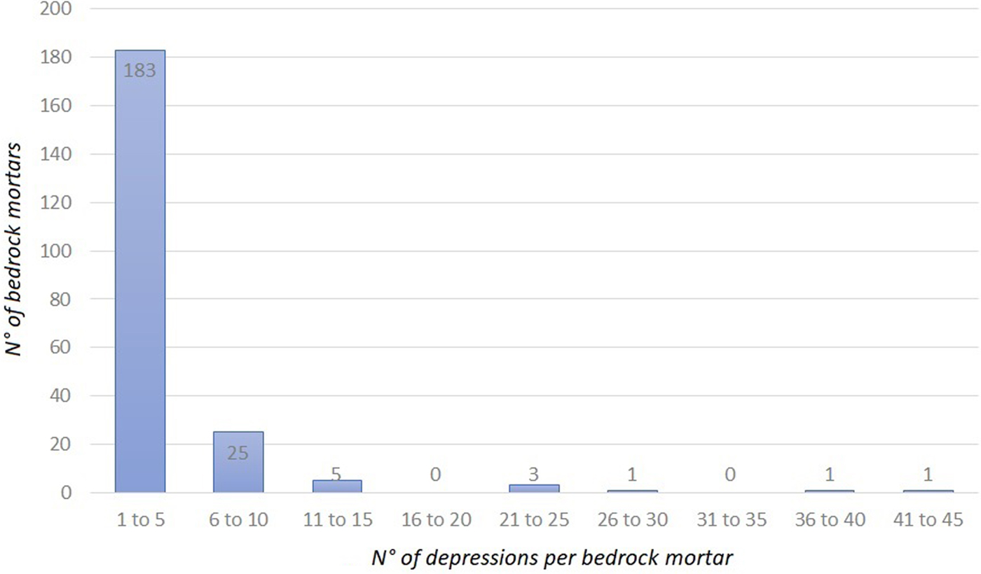
The number of depressions can be assessed two ways, by the number per rock, and by the number per site. The maximum number per rock (Figure 4) tends not to exceed 10 in 95% of cases, and is generally between 1 and 5 (83.56%). Again, the exception is VEE, which has rocks with up to 45 mortars, followed by Rocas de Quiles and Agua Estancada, both with a maximum of 23 depressions per rock. In general terms, no direct relation was observed between the size of the rock, its usable surface and the number of depressions. Thus, the number of depressions in a support is not dictated by rock size but is instead related to a cultural choice associated with the dynamics of the practices established at the site (Pino Reference Pino2014; Troncoso et al. Reference Troncoso, Pino, Belmar, Belmar, Contreras and Reyes2017).
Regional distribution of the number of mortars per bedrock support. (Color online)

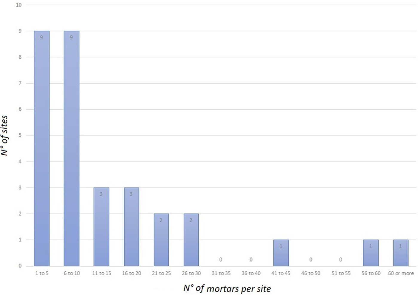
If, on the other hand, we consider the number of depressions per site, again excluding VEE, which contains 423 mortars, we see that more than half the sites (54%) contain no more than 10 mortars (Figure 5). Those with the most depressions are Rocas de Quiles (n = 59), Tamaya-1 (n = 41), Agua Estancada (n = 25) and Maitencillo-7 (n = 21; Table 1).
Regional distribution of mortars per site. (Color online)

If we compare the north and south banks of the Limarí River, we see that both contexts and bedrock mortars are more frequent on the south side (Table 2), resulting logically in a larger number of mortars, even excluding VEE. The number of depressions per rock north of the river varies from 1 to 10, whereas south of the river, it varies much more widely, from 1 to 23. If we look at the number of depressions per site (again excluding VEE), we find that sites to the south present more and a greater variability in shapes (Table 1).
Trend Comparison of Bedrock Mortars from the Northern and Southern Sectors of the Limarí Basin.

VEE = Valle El Encanto; * includes only 6% of the bedrock mortars at the site.
In typological terms, only cupuliform mortars are recorded in the north of the river, while to the south, the whole range of types can be found, showing juxtapositions of different types of mortars. This greater complexity is reflected in the presence of different types of depressions in the same rock, and in the existence of ordered groups of depressions in a single rock (Pino Reference Pino2014; Troncoso et al. Reference Troncoso, Pino, Belmar, Belmar, Contreras and Reyes2017).
In most of the rocks with only one depression, the mortar is placed on one side, as if to allow the incorporation of another person onto the block. The same is apparent in the ordering and execution of depressions around the edges of the rock, with greater wear on the sides closest to the edges. This characteristic suggests postures for the participating subjects, which would facilitate the incorporation of others into grinding activities at the same block for collective activity (sensu Pastor Reference Pastor and Salazar2015).
Turning to the volume of ground-out rock, ellipsoid mortars present the highest volume, followed by the rectangular, cupuliform, and mixed types, in that order of representation. The deepest cupuliform mortars are found at Pintadas de Quiles (support 1, mortar 5: 17.3 cm – 850 cc) and Talhuenal de Quiles (support 3, mortar 6: 18 cm – 1330 cc); the largest ellipsoid depressions are at Talhuenal de Quiles (support 6, mortar 3: 16 cm – 4460 cc); and the largest rectangular mortars at Rocas de Quiles (support 1, mortar 19: 8.7 cm depth – 2380 cc).
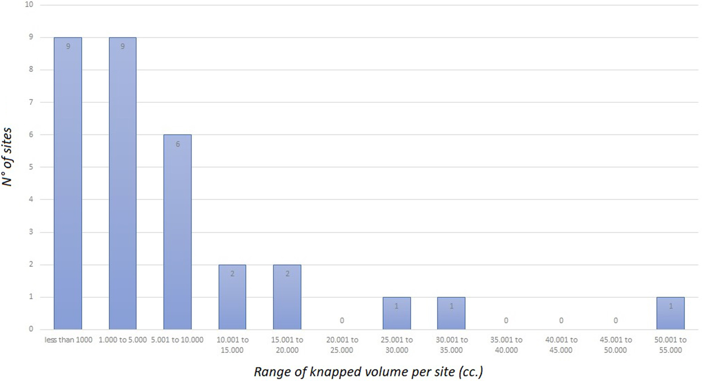
VEE also breaks all the regional trends for total volume of depressions per site (Pino Reference Pino2014; Troncoso et al. Reference Troncoso, Pino, Belmar, Belmar, Contreras and Reyes2017). With only 6% of the depressions measured, the total had already reached 34,170 cc; if we project the total to 100% of the site, this would give 495,217 cc, more than twice the combined total of all the other sites in the region (Table 1). If VEE is excluded, we find that 80.64% of the sites present a total mortar volume of less than 10,000 cc, and the site with the highest investment of effort was Rocas de Quiles (53,580 cc), followed by Talhuenal de Quiles (27,075 cc) and Pintadas de Quiles (16,270 cc), all located to the south of the Limarí River, and with greater complexity of typology, as noted above (Figure 6).
Range of knapped volume of depressions by site on a regional scale. (Colour online)

Stratigraphic Contexts and Spatial Relations
As we have said, all the sites with bedrock mortars are located in the lower part of the Limarí basin, never more than 47 km from the coast, and with different patterns of aggregation (Figure 1). Spatially, the bedrock mortars are not found in isolation but are associated with residential sites with abundant surface cultural material. Stratigraphic excavations provide evidence of contexts interpretable as residential camps of hunter-gatherer groups (Troncoso et al. Reference Troncoso, Vergara, Pavlovic, González, Pino, Larach, Escudero, La Mura, Moya, Pérez, Gutiérrez, Pascual, Belmar, Basile, López, Dávila, Vásquez and Urzúa2016, Reference Troncoso, Pino, Belmar, Belmar, Contreras and Reyes2017). They are all associated with secondary water courses such as ravines and streams. Finally, bedrock mortars tend not to be found scattered around the sites, but form intervisible groupings (Pino Reference Pino2014; Troncoso at al. Reference Troncoso, Pino, Belmar, Belmar, Contreras and Reyes2017).
The excavations carried out at 11 sites showed that bedrock mortars are associated with residential camps of both the Late Archaic and the ECP. In particular, the dates of the contexts obtained in the immediate vicinity of the bedrock mortars show a clear trend towards greater use of these spaces during the ECP; sites associated with the Archaic are scarce (Table 1). At the same time, the sites with a greater variety of shapes coincide with later dates within the ECP, and also present a larger knapped volume (excluding VEE) and deeper depressions (e.g., Rocas de Quiles, Talhuenal de Quiles, Pintada de Quiles). The deposits with earlier dates and/or contexts generally present mortars of the cupuliform type, fewer depressions per support, and a lower mortar volume per site (Table 1).
Plant Microfossil Analysis
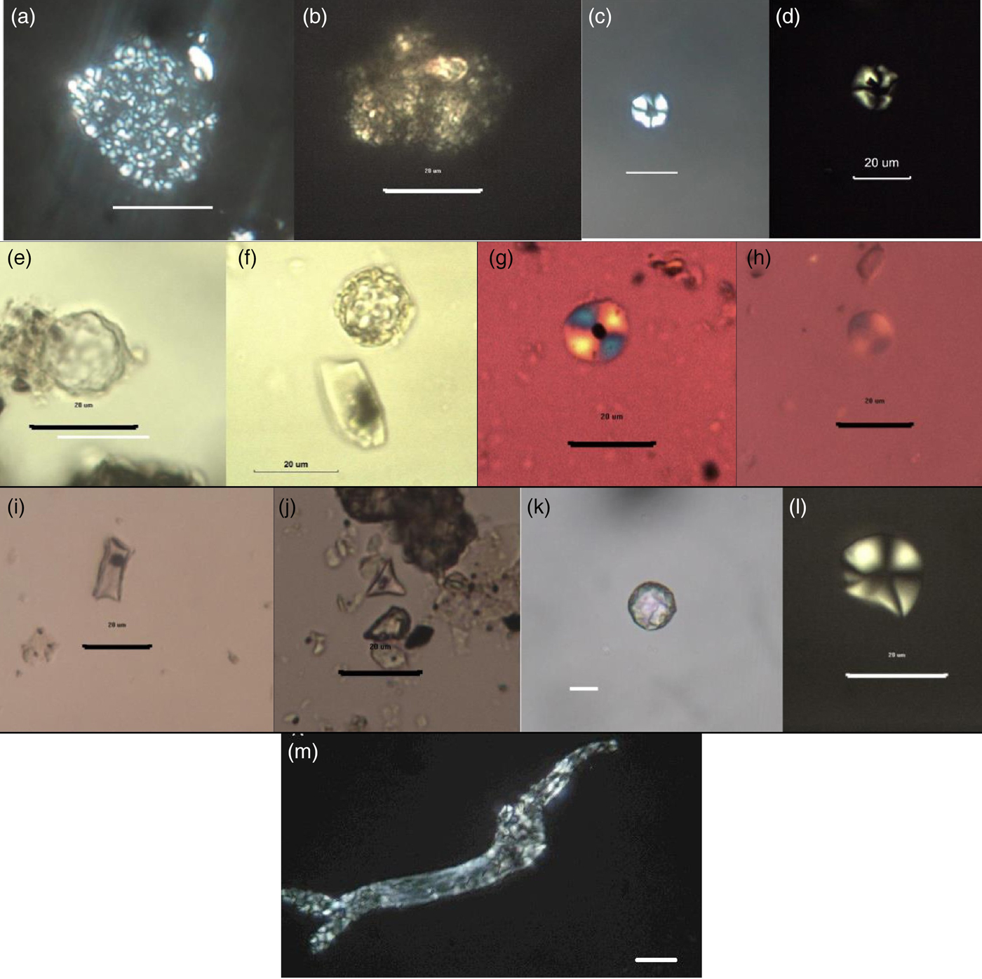
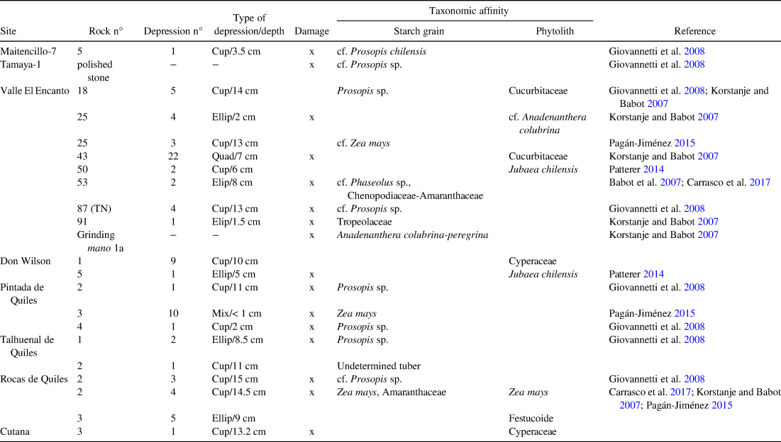
Evidence of microfossils was found in 83% (n = 81) of the depressions (Table 3, Figure 7). Phytoliths (n = 808) were the most abundant microfossils. The next most frequent were calciphytoliths (n = 260), followed by starch grains (n = 97), plant tissue (n = 73), pollen (n = 49), diatoms (n = 54) and microcarbons (n = 8; Table 3).
Microfossils recovered from bedrock mortars: a–b) Amaranthaceae-Chenopodiaceae starch aggregates; c–d) Prosopis sp. starch grain; e–f) Jubaea chilensis or Chilean palm globular echinate phytolith; g–h) Zea mays starch grain; i) Zea mays wavy-top phytolith; j) Cyperaceae phytolith, k) globular phytolith; l) unidentified tuber starch grain; m) Anadenanthera colubrina pack of starch grains. Scale 20 µm. (Color online)

Absolute Frequency of Types of Microfossils Recovered from Mortar Depressions, Specifying Taxonomic Affinity.

As Table 3 shows, we identified the presence of various wild and domesticated plants (Figure 7). Among wild plants, there is a remarkable recurrence of Prosopis sp. and cf. Prosopis sp. starch grains (algarrobo; Giovannetti et al. Reference Giovannetti, Verónica Lema and Capparelli2008) in five sites (Maitencillo-7, VEE, Pintados de Quiles, Talhuenal de Quiles, and Roca de Quiles), which were also found in residues adhering to a polished stone from the Tamaya-1 site. A globular echinate morphotype, found in leaves of the Chilean palm (Jubaea chilensis; Patterer Reference Patterer2014), was identified at two sites (VEE and Don Wilson); phytoliths from Cyperaceae were also found at two sites (Don Wilson and Cutana). Isolated microfossils of Amaranthaceae-Chenopodiaceae and Tropeolaceae (VEE), Festucoideae (Rocas de Quiles), and a starch grain from an undetermined tuber (Talhuenal de Quiles) were also found.
Among the wild plants, we recognized a fiber structure with starch grains of cf. Anadenanthera colubrina (cebil; Korstanje and Babot Reference Korstanje, Babot, Madella and Zurro2007) in VEE; we also recorded a subspherical phytolith with central depression described for the same plant (Korstanje and Babot Reference Korstanje, Babot, Madella and Zurro2007) on a grinding stone recovered close to the same bedrock mortar. The suggested identification of these microfossils as cf. Anadenanthera colubrina is supported by multiple analyses of microfossils (Coil et al. Reference Coil, Korstanje, Archer and Harstof2003), their similarity to the two morphotypes described for the species (Korstanje and Babot Reference Korstanje, Babot, Madella and Zurro2007), and the fact that they were found in a single limited area of the site. Among domesticated plants, remains of Zea mays were found at three sites (VEE, Pintadas de Quiles, and Rocas de Quiles). A silicophytolith of Cucurbitaceae and another from a trichome cf. Phaseolus sp. were found in VEE.
All the taxa identified are plants of economic value. The majority were used as food (maize, algarrobo, bean, Amaranthaceae, tuber, Cucurbitaceae) from which by-products such as flour and fermented or unfermented beverages can be obtained (Pardo and Pizarro Reference Pardo and Pizarro2013). Others provide fibers that could be used as raw material (Chilean palm leaves, Festuca, and Cyperaceae; Pardo and Pizarro Reference Pardo and Pizarro2013).
The finding of microfossils of Anadenanthera colubrina (cebil) in a mortar depression and on a grinding stone at VEE is of particular note, because this species is not indigenous to the region and is traditionally associated with ritual practices, because of its hallucinogenic properties (Torres and Repke Reference Torres and Repke2012). Considering that VEE has been defined as a large aggregation site associated with rock art and bed rocks, the psychoactive plant could have played a part in the intense social dynamics that took place there (Troncoso et al. Reference Troncoso, Pino, Belmar, Belmar, Contreras and Reyes2017).
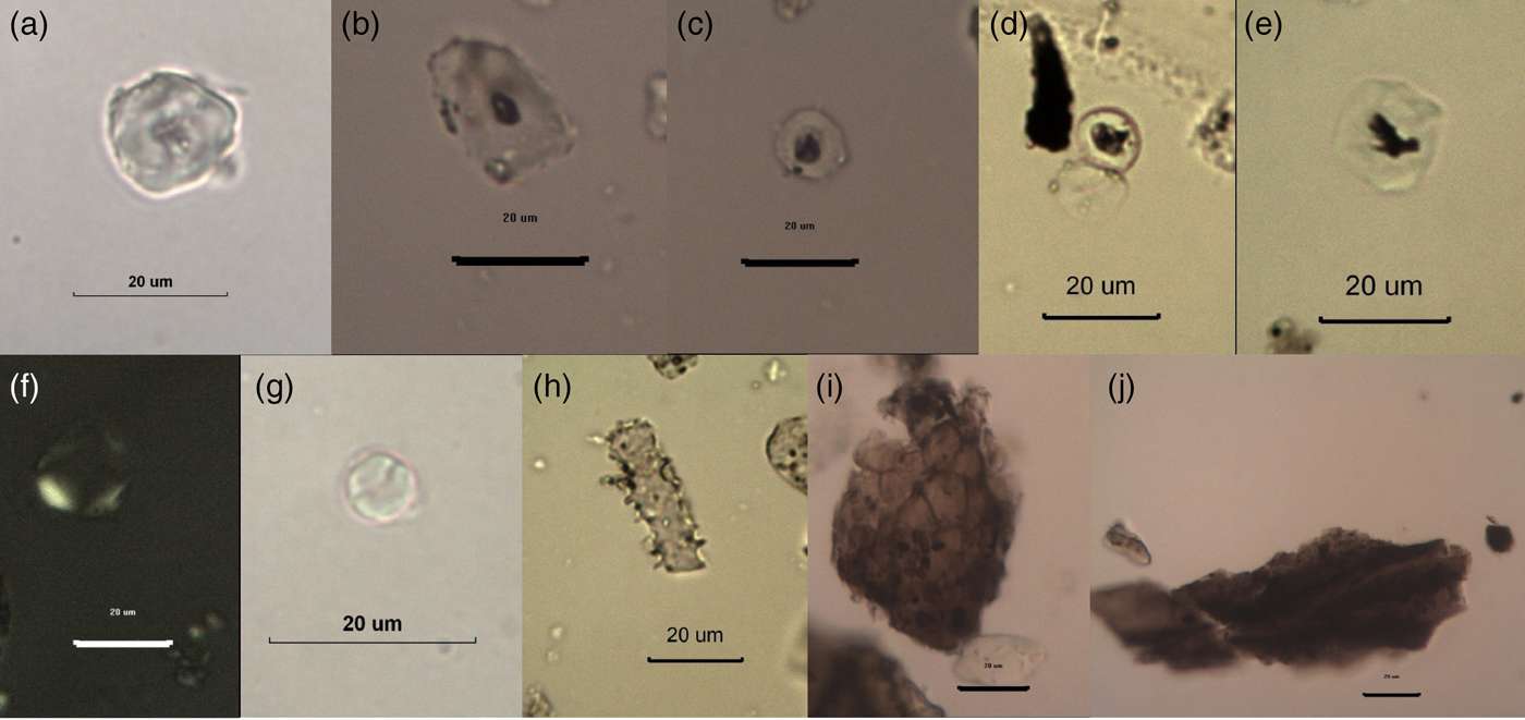
Although the set of taxonomically identified microfossils was small, it is significant that 63% of all the microremains recovered presented marks that could be related to plant processing and/or damage caused by weathering due to exposure; the mortars are exposed and not buried (Figure 8; Babot Reference Babot, Marconetto, Oliszewski and Babot2007b; Haslam Reference Haslam2004). This fact, in conjunction with the recovery of residues from active pieces associated with grinding, allow us to maintain that these plants were processed in these bedrock mortars.
Damaged microfossils. a) gelatinized starch grain; b–d) damaged starch grain with dark central area on the extinction cross; e) damaged starch grain of Prosopis sp. with dark central area on the extinction cross; f) birefringence damage; g) fractured starch grain; h) fractured long cell phytolith; i–j) plant tissue exposed to heat and fire. (Color online)

Discussion
The manufacture and use of bedrock mortars was a recurrent practice by hunter-gatherer communities of the late Holocene in the Limarí River basin. Regional trends can be identified, and also some changes that occurred over time, which can be evaluated to assess the importance of grinding and the use of plant resources among these populations.
Although this evidence indicates that bedrock mortars were a recurrent, intense, and uniform phenomenon, they were restricted exclusively to the coast and coastal valleys. The bedrock mortars distributed in the lower Limarí River basin present little variation in type and number. The best example of this homogeneity is the high recurrence of cupuliform mortars as compared to other shapes. The overrepresentation of this type and the scarce presence of superimpositions do not necessarily reflect a “typological evolution” in the depressions, and this is supported by the fact that the few superimpositions found are of cupuliform mortars on ellipsoid types.
The spatial restriction of bedrock mortars to the lower course of the Limarí, from the Late Archaic at least, is the result of different historical dynamics between the upper and lower course of the basin. This difference is also supported by differentiated rock art of the hunter-gatherer groups, and the presence of large cemeteries on the coast and their absence from the interior (Troncoso et al. Reference Troncoso, Vergara, Pavlovic, González, Pino, Larach, Escudero, La Mura, Moya, Pérez, Gutiérrez, Pascual, Belmar, Basile, López, Dávila, Vásquez and Urzúa2016).
Within the recognized general homogeneity, there are two variations that we consider significant. First is the exceptional nature of the VEE site, where the evidence suggests an intensity of social practices that has not been recognized in any other space in the region and leads us to understand it as a social aggregation site for the hunter-gatherer communities (Troncoso et al. Reference Troncoso, Pino, Belmar, Belmar, Contreras and Reyes2017). Second is the difference between the north and south banks of the basin in the intensity and diversity of bedrock mortar manufacturing practices. These variations appear to be related to the dynamics and intensity of the occupation of the two spaces. The northern zone has more topographic relief, while the southern zone is flatter and more suitable for residential camps typical of the settlement patterns of hunter-gatherers during the late Holocene.
The combination of the spatial associations of the mortars and the absolute dates obtained in adjacent excavations suggest that they were not restricted to a specific historical-cultural moment but were manufactured by hunter-gatherer populations of the Late Archaic and the ECP (Schiappacasse and Niemeyer Reference Schiappacasse and Niemeyer1965–1966). This is not surprising, because other lines of evidence have shown that there is a series of continuities linking the two periods (Troncoso et al. Reference Troncoso, Vergara, Pavlovic, González, Pino, Larach, Escudero, La Mura, Moya, Pérez, Gutiérrez, Pascual, Belmar, Basile, López, Dávila, Vásquez and Urzúa2016). If we consider the dates of the contexts immediately surrounding the bedrock mortars, we find a distribution from 1608–1432 BC to AD 999–1145 (Table 1). This range goes further back, to 2127–1892 BC, if we use the earliest dates obtained from any of these sites but from an excavation that was not close to any bedrock mortars. The homogeneity referred to above therefore indicates that during a period of at least 2,500 years when bedrock mortars were being manufactured, we cannot discern with any certainty an evolution in the shape of the depressions; it is highly probable that cupuliform mortars were being made over the whole of this period.
Nevertheless, we think it is of greater interest to discuss whether or not any variation can be observed in grinding practices over these 2,500 years, and if so, how they related to social processes. The evidence, taken together, leads us to suggest that variation over time can be detected, associated with an increase in the intensity of grinding practices in the region.
Considering the absolute dates, we observe that they tend to be concentrated in the ECP rather than the Late Archaic. If we exclude VEE, the sites presenting the largest number of supports and depressions, the greatest typological diversity and the deepest mortars are usually dated to the ECP, generally towards the end of the period (especially those presenting ellipsoid and/or rectangular examples). In contrast, the sites with smaller numbers of supports and depressions, presenting only the cupuliform type and with smaller total mortar volumes, would be associated with the Late Archaic. The same pattern is repeated at the coastal sites studied by Schiappacasse and Niemeyer (Reference Schiappacasse and Niemeyer1964, Reference Schiappacasse and Niemeyer1965–1966), with small numbers of support rocks and depressions in Guanaqueros, El Pimiento, and Punta Teatinos, all Late Archaic sites.
This pattern indicates that the practice of grinding in bedrock mortars started at the beginning of the Late Archaic and increased during the ECP, to reach a peak at the end of the period. We think that this increase in grinding practices occurred on two distinct but complementary levels. First, an increase in the practice would explain the increasing total volume of bedrock mortars; these may have been used to grind varied materials because many of the mortars with larger volumes are ellipsoid in shape. Second, grinding practices can be seen as collective activities, because increasing the number of mortars per rock allowed more people to be involved in the same task together. This indicates that not only did grinding practices intensify, but that their materiality served to promote a greater interaction of subjects around the rock when engaged in grinding plant resources, converting it into a space for interaction and active participation in the formation of subjects and communities (sensu Pastor Reference Pastor and Salazar2015).
We would like to draw attention to some chronological aspects of our findings. First, although it is not impossible that a single depression may have been reused over a period of many years (with alternating stages of use/disuse), the evidence does not support such a pattern: that maximum depths do not exceed a specific value (17 cm), and that diameters of the mouths present no major variations or irregularities suggests rather that when reuse occurred, it was through the manufacture of new depressions in the same support and/or other supports that were also used for grinding purposes. Second, although it cannot be determined whether all the depressions in a single rock were manufactured at the same moment or not, this is unlikely to have been the case, and each support probably results from the accumulation of multiple practices over time. This accumulation, which allows more people to work at the same rock (and without superimposing one mortar on another), together with the increase in the volumes of the mortars and sites containing bedrock mortars at the end of the ECP, reflects the centrality of this practice and its function as a space for the constitution of social relations between groups. Likewise, the exceptional nature of the contexts at VEE reaffirms the significance of grinding plant resources in the construction of social relations in these communities. Finally, because we were only able to establish a taxonomic affinity for 24 morphotypes of microfossils, we cannot discuss whether or not the morphological changes described in the depressions can be attributed to the processing of different plant resources.
This process of increasing centrality and intensity of grinding activity appears to be consistent with the dynamics of other social practices in the region. The study of settlement patterns and lithic technologies (Troncoso et al. Reference Troncoso, Vergara, Pavlovic, González, Pino, Larach, Escudero, La Mura, Moya, Pérez, Gutiérrez, Pascual, Belmar, Basile, López, Dávila, Vásquez and Urzúa2016) suggests a reduction in mobility from the Late Archaic to the ECP; however, occupation of the coastal region diminished notably during the ECP compared to previous periods (Ampuero Reference Ampuero2010; Niemeyer et al. Reference Niemeyer, Castillo, Cervellino, Hidalgo, Schiappacasse, Niemeyer, Aldunate and Solimano1989). At the same time, the archaeological contexts of the ECP show a marked absence of zooarchaeological remains in both this and neighboring regions, indicating a reduction in hunting and exploitation of terrestrial mammals, as suggested by isotopic studies that show low intake of animal protein (Gómez and Pacheco Reference Gómez and Pacheco2016; López et al. Reference López, Cartajena, Santander, Pavlovic and Pascual2015; Troncoso et al. Reference Troncoso, Vergara, Pavlovic, González, Pino, Larach, Escudero, La Mura, Moya, Pérez, Gutiérrez, Pascual, Belmar, Basile, López, Dávila, Vásquez and Urzúa2016). In neighboring areas, this process is associated with a demographic decrease due to overexploitation of ungulates in earlier times prior to the appearance of pottery (Neme et al. Reference Neme, Wolverton and Gil2012). We believe that all this evidence points to a specific process, namely the increased centrality of plant grinding in the ECP as opposed to other practices such as camelid hunting. This would be associated with greater use of interior spaces away from the coastline and an increasingly less-mobile settlement dynamic using smaller streams, which offered a rich sclerophyllous plant community. Today this type of plant association is defined by high diversity and is represented by varied life forms such as high sclerophyte shrubs, spiny xerophilous shrubs, succulents, and sclerophyllous and laurifolious trees (Gajardo Reference Gajardo1993).
Collective grinding practices would promote and intensify social relations between the various subjects making up the mobile group, thanks to the distribution of the bedrock mortars in the site (intervisibility) and the spatial layout of the depressions on the rocks (communal work). The centrality of this practice, finally, would mean that the space would experience increasing intervention in the form of bedrock mortars, creating a landscape marked by the practice of grinding, which in turn structured the social relations and practices of community members.
For several decades, maize has been proposed as the most important plant resource ground in these ECP contexts. Although there was little evidence, restricted to just a few examples at the San Pedro Viejo de Pichasca site (Ampuero and Rivera Reference Ampuero and Rivera1971b), this hypothesis was based on an evolutionary vision that associated the appearance of pottery with sedentism and agriculture (Ampuero and Hidalgo Reference Ampuero and Hidalgo1975; Niemeyer et al. Reference Niemeyer, Castillo, Cervellino, Hidalgo, Schiappacasse, Niemeyer, Aldunate and Solimano1989). This concept has been reassessed in recent years (Méndez et al. Reference Méndez, Andrés Troncoso and Jackson2009; Troncoso et al. Reference Troncoso, Vergara, Pavlovic, González, Pino, Larach, Escudero, La Mura, Moya, Pérez, Gutiérrez, Pascual, Belmar, Basile, López, Dávila, Vásquez and Urzúa2016). Our data show that maize microfossils are scarce in these contexts and associated principally with sites dated to around AD 1000, with the exception of VEE. The presence of algarrobo, in contrast, is notable. Although discussion in many studies of this region and neighboring territories has stressed the importance of maize, the fact remains that cases such as this oblige us to reassess the role of algarrobo in the diet and the economy of hunter-gatherer groups of the late Holocene. The fruits and subproducts of algarrobo contributed a large quantity of carbohydrates to the diet of the population (363 kcal, Prosopis flexuosa; Llanos et al. Reference Llanos, Andrew, Alejandra and Otaola2012), and algarrobo trees would have been very frequent in the landscape of the region (Camus Reference Camus2004), making it a readily available resource.
In this context, the evidence does not suggest that the appearance of pottery triggered farming and sedentarism. On the contrary, the incorporation of pottery would have been a technological innovation occurring in the framework of a wider process associated with increased importance of plant resources for the economic and social life of these communities, and a reorientation of settlement patterns inland, away from coastal spaces. Consistent with the above patterns, the greatest frequency and variety of forms of pottery are observed in the final moments of the ECP, when an increase in plant processing can be observed (Troncoso et al. Reference Troncoso, Vergara, Pavlovic, González, Pino, Larach, Escudero, La Mura, Moya, Pérez, Gutiérrez, Pascual, Belmar, Basile, López, Dávila, Vásquez and Urzúa2016). The incorporation of pottery offered new possibilities for storing, processing, and transporting these plant resources, a concept which has not yet been explored for this region.
Identification of other plants used in the area such as Chilean palm, algarrobo, Tropeolaceae, Festucoideae, and Cyperaceae, and their relative frequency of occurrence, reflect the greater importance of wild rather than domesticated resources. Maize would have been complementary to the other plant resources collected from the environment. This relative unimportance of maize is consistent with the isotopic studies performed in the region, which suggest that the enrichment of diets with C4 belongs to the Diaguita contexts of the Late Intermediate Period, which is when other evidence indicates the introduction of a sedentary, agricultural way of life (Alfonso et al. Reference Alfonso, Andrés Troncoso, Larach and Becker2017; Troncoso et al. Reference Troncoso, Vergara, Pavlovic, González, Pino, Larach, Escudero, La Mura, Moya, Pérez, Gutiérrez, Pascual, Belmar, Basile, López, Dávila, Vásquez and Urzúa2016). Isotope studies in the neighboring Choapa valley show a similar situation, in which individuals associated with ECP contexts present little or no C4 enrichment (Gómez and Pacheco Reference Gómez and Pacheco2016). At the same time, we have obtained two direct dates close to AD 1000 for maize recovered from contexts with Molle pottery (Beta 450752: 670 ± 30 14C yr BP, 1296–1396 cal AD; Beta 463226: 1070 ± 30 14C yr BP, 909–1138 cal AD).
This accumulation of evidence enables us to infer that bedrock mortars must have appeared towards the beginning of the Late Archaic, reflecting the implementation of a new materiality associated with grinding and processing plants. Their appearance is associated with the start of the process in which spaces were demarcated, contemporaneous with the development of the first manifestations of rock art in the region (Troncoso et al. Reference Troncoso, Vergara, Pavlovic, González, Pino, Larach, Escudero, La Mura, Moya, Pérez, Gutiérrez, Pascual, Belmar, Basile, López, Dávila, Vásquez and Urzúa2016). In fact, bedrock mortars seem to form part of a package of new material elements that appear and start to structure and promote new types of social relations between subjects, and also a different form of articulation with space, now defined by the effective transformation of rock elements for the demarcation of the landscape.
During the Late Archaic, however, there was a strong tendency by these populations to exploit the coastal zone, and this—combined with the low intensity of bedrock mortar manufacture—suggests a secondary role for plant collection, corroborated by the isotopic data (Alfonso et al. Reference Alfonso, Andrés Troncoso, Larach and Becker2017). Towards AD 1, for reasons as yet unclear, there seems to have been a reduction in the exploitation of coastal resources and an increase in plant collection, leading to reduced occupation of the coastline and greater occupation of the coastal valleys. This process intensified over the next millennium, in parallel with reduced mobility patterns and greater use of the inland spaces of the lower Limarí basin. This increased centrality of plant resources complements the greater importance of grinding practices and the formation of social relations through more collective activities. At the same time there was a greater investment of practices and energy in the manufacture of bedrock mortars, and possibly new forms of grinding were developed, as suggested by the later dates attributed to ellipsoid depressions. This activity would have reached its maximum intensity around AD 1000, after the constitution of a completely agricultural, sedentary way of life by the Diaguita communities.
This situation would imply that the period over which activities switched from a maritime economy to one focused on exploitation of plant resources would have been longer than proposed by Schiappacasse and Niemeyer (Reference Schiappacasse and Niemeyer1964, Reference Schiappacasse and Niemeyer1965–1966), extending to almost 3,000 years. This process involves three situations that should be explored in greater depth. First is a historical dynamic in which, after the adoption of pottery, the communities increasingly exploited plant resources in preference to hunting. Second is late adoption of an agricultural way of life, based on cultivation and consumption of maize, which is clearly observed in the region after AD 1000. Finally, and notwithstanding the above, is the presence of maize in hunter-gatherer contexts, coexisting with exploitation of other predominant plant species such as algarrobo.
Conclusions
Rosenberg and Nadel (Reference Rosenberg and Nadel2017) recognize that bedrock mortars were deeply connected with social life, reflecting a plethora of human behaviors. Burton and others (Reference Burton, Adams, Willis and Nadel2017) stress the relation between this material record and the construction of the landscape. Nevertheless, the fact remains that work on bedrock mortars has focused mainly on their productive aspects, although few studies have sought to integrate bedrock mortars with the social processes of the past (e.g., Babot Reference Babot2006; Giovannetti Reference Giovannetti, Austral and Tamagnini2008, Reference Giovannetti, Belmar, Contreras and Reyes2017; Pastor Reference Pastor, Nilsen, Rivolta, Seldes, Vásquez and Mercolli2007, Reference Pastor and Salazar2015). This is largely because studies of bedrock mortars have focused on discussion of one or two aspects of their variation, without taking a multiscale regional view to understand the phenomenon. Limitations associated with dating and chronological location of bedrock mortars are another explanation for marginalization of the record (Rosenberg and Nadel Reference Rosenberg and Nadel2017).
Here, we have tried to integrate bedrock mortars into the social and historical processes of late Holocene hunter-gatherers in the SAN of Chile. We have combined different lines of evidence and levels of analysis in order to understand bedrock mortars as “entangled with embedded social data” (Rosenberg and Nadel Reference Rosenberg and Nadel2017). Our results suggest a process of economic transformation from communities with a coastal orientation to the procurement of inland resources. This transformation occurred over a broad time scale and brought new forms of articulation between the members of the mobile community and their landscape. It is part of the process of transition towards agriculture in the region, when plant resources were acquiring greater importance within the economic practices of these communities. The same situation occurred in other spaces in the southern Andes (Babot Reference Babot2006; Pastor Reference Pastor, Nilsen, Rivolta, Seldes, Vásquez and Mercolli2007, Reference Pastor and Salazar2015), suggesting that bedrock mortars played an important role in these historical processes.
Nonetheless, the production and proliferation of bedrock mortars also implied a transformation in the ways social relations were articulated between subjects, creating performative spaces of interaction between members of a community, based on grinding practices. The capacity of this material record to generate social relations has already been discussed by other authors (Giovannetti Reference Giovannetti2015; Pastor Reference Pastor and Salazar2015). The immovable character of the rocks implies bedrock mortars conditioned the space where they are located, at both intrasite (promoting a proxemic between subjects) and regional levels, structuring the practices of social subjects consistent with their historical processes (Pastor Reference Pastor and Salazar2015; Troncoso et al. Reference Troncoso, Pino, Belmar, Belmar, Contreras and Reyes2017). In line with the above, bedrock mortars not only promoted a type of social relation from collective plant grinding, but created, through their spatial distribution, a particular historical landscape marked by the relationship between humans, plant resources, and grinding practices (Burton et al. Reference Burton, Adams, Willis and Nadel2017).
Through this multiscale, multidimensional focus, we have explored how the appearance and intensification of bedrock mortars were associated with the complex historical transformation of the hunter-gatherers of the SAN of Chile. This process was not only productive and economic, but also involved changes in social relations and the construction of the landscape, reflecting the close interconnection of the production and use of bedrock mortars with the historical processes of prehispanic communities.
Acknowledgements
To Frances Hayashida, the reviewers, and editors for their comments. To CONICYT for financing this work through FONDECYT Projects 1150776.
Data Availability Statement
The materials excavated and the digital data used on this paper are available in the Department of Anthropology of Universidad de Chile. All of this information is available by request to the authors.
Supplemental Materials
For supplemental material accompanying this article, visit https://doi.org/10.1017/laq.2018.52
Supplemental Table 1: Detailed Characterization of Limarí River Basin Bedrock Mortars.