One of the strengths of archaeology as a social science is its ability to analyze evidence for human behaviors over extended periods of time and space (Smith et al. Reference Smith, Feinman, Drennan, Earle and Morris2012). Related to this is its ability to analyze evidence over varied chronological and spatial scales, thereby discovering patterns that are not visible in single temporal and spatial frames. Such multiscalar analyses have been used to good effect in a myriad of situations worldwide using a variety of analytical methods and techniques. These include social network analysis (SNA), which by its very nature facilitates analyses of human interactions at various scales (Mills et al. Reference Mills, Peeples, Haas, Borck, Clark and Roberts2015). Here, we expand on previous SNA of mid-fourteenth through mid-seventeenth-century (all dates in this article are AD) Northern Iroquoia in southern Ontario (Birch and Hart Reference Birch and Hart2018; Hart et al. Reference Hart, Shafie, Birch, Dermarker and Williamson2016), taking advantage of refined chronological control, which has resulted from recently completed Bayesian analyses of radiocarbon dates (Birch et al. Reference Birch, Manning, Sanft and Conger2021; Manning et al. Reference Manning, Birch, Conger, Dee, Griggs, Hadden, Hogg, Ramsey, Sanft, Steier and Wild2018, Reference Manning, Birch, Conger, Dee, Griggs and Hadden2019). As in our previous work, we identify design motifs on the collars of cooking pots as signals of network membership by the makers and users of those pots—primarily women—who in turn were active in the sociopolitical interactions of ancestral Iroquoian village communities (Birch and Hart Reference Birch and Hart2018; Hart and Engelbrecht Reference Hart and Engelbrecht2012). Site-specific assemblages of decorated collars are used in SNA to generate signaling networks as proxies for human sociopolitical interactions.
Northern Iroquoian societies occupied—and continue to occupy—portions of present-day New York, Ontario, and Québec. This article focuses in particular on one Iroquoian population in southern Ontario, Canada, which is composed of ancestors of the contemporary Huron-Wendat Nation. Ancestral Huron-Wendat communities occupied portions of Ontario and Quebec, with dense clusters of settlement located on multiple drainages flowing south into Lake Ontario. These patterns persisted until the early seventeenth century when their population coalesced in the Simcoe Uplands, located between Lake Simcoe and Lake Huron's Georgian Bay, a territory known as historic Wendake. Although early Iroquoian settlements had been present in that region since the fourteenth century, the gradual agglomeration of population there seems to have been related to the formation of the Wendat confederacy, whose core membership was concentrated in this region during the early seventeenth century (Trigger Reference Trigger1976).
In previous efforts, we have used SNA to understand how interactions between ancestral Huron-Wendat villagers changed through time from 1350 to 1650 across the north shore of Lake Ontario and northward to historic Wendake and the adjacent Tionontaté (Petun) territory (Birch and Hart Reference Birch and Hart2018; Hart et al. Reference Hart, Shafie, Birch, Dermarker and Williamson2016). In these macroscale analyses (following Mills et al. Reference Mills, Peeples, Haas, Borck, Clark and Roberts2015), we found that, from 1350 to 1450, ancestral Huron-Wendat villagers were strongly interwoven in regional signaling networks. Our analyses of village sites from 1450 to 1650 indicated complete networks with bonding ties and an increased use of meta-identifier designs on pottery collars as one mechanism to integrate communities into a confederacy that coalesced in a restricted geographical area (Birch and Hart Reference Birch and Hart2018; Hart et al. Reference Hart, Shafie, Birch, Dermarker and Williamson2016). This trend, however, was not a straight-line trajectory. Important changes occurred in signaling networks that tracked regional sociopolitical developments and patterns of intra- and interregional conflicts throughout the time span. For example, during the period of increased conflict and coalescence of villages into larger settlements, signaling became more inwardly focused within geographical clusters of villages (Hart et al. Reference Hart, Shafie, Birch, Dermarker and Williamson2016:19).
Mills and colleagues (Reference Mills, Peeples, Haas, Borck, Clark and Roberts2015) demonstrate how multiscalar SNA can result in important insights into regional trends. Although our macroscale SNA has resulted in new understandings of regional interactions in response to changing sociopolitical developments and regional conflict, microscale analyses are needed to understand how these trends played out within particular subregions. An SNA of early Iroquoian sites in historical Onondaga territory in the Finger Lakes region of New York, for example, showed how signaling networks changed substantially over short periods of time within one discrete subregional population (Hart and Engelbrecht Reference Hart, Engelbrecht, Jones and Creese2017).
Recent Bayesian analyses of large suites of radiocarbon dates have refined our knowledge of regional time frames as well as the nature of coalescence and conflict in Iroquoia (Birch et al. Reference Birch, Manning, Sanft and Conger2021; Manning et al. Reference Manning, Birch, Conger, Dee, Griggs, Hadden, Hogg, Ramsey, Sanft, Steier and Wild2018, Reference Manning, Birch, Conger, Dee, Griggs and Hadden2019). Here, we incorporate this new knowledge into microscale and mesoscale (Mills et al. Reference Mills, Peeples, Haas, Borck, Clark and Roberts2015) SNA to understand how the macroscale trends played out in a sequence of sixteenth- to early seventeenth-century village sites in the West Duffins Creek drainage. Mesoscale refers to the north shore of Lake Ontario subregion, whereas microscale refers to specific communities and local village relocation sequences. Our results suggest that although coalescence may have initially involved the incorporation of peoples from microscale (local) networks, populations originating among wider mesoscale (subregional) networks also contributed to later coalescent communities, especially as conflict between Wendat and Haudenosaunee populations escalated in the sixteenth century. These results further ongoing efforts to understand the dynamic and multilinear nature of Northern Iroquoian settlement systems (see also Birch Reference Birch and Gyucha2019; Birch and Lesage Reference Birch, Lesage, Lamoureux-St-Hilaire and Macrae2020; Hart Reference Hart2020), as opposed to overly simplified models of both site relocation sequences and coalescence and conflict.
Site Relocation Sequences
From the fourteenth century onward, ancestral Huron-Wendat communities lived in villages consisting of multiple longhouses (Birch and Williamson Reference Birch, Williamson, Birch and Thompson2018). In southern Ontario, during the sixteenth and seventeenth centuries, these villages became quite large and in some cases reached estimated populations of 1,500–2,000 individuals (Warrick Reference Warrick2008). These later, larger settlements were more often than not surrounded by multirow defensive palisades. Villages were typically single component, although the reoccupation of village sites is not unknown (Hawkins et al. Reference Hawkins, Malleau and Elliott2018).
Ancestral Wendat settlements are generally thought to have been occupied for a few decades (Warrick Reference Warrick1988) before communities established new villages at a distance of several kilometers. This was done for a variety of social and environmental reasons. Depletion of firewood, deterioration of structures, pest infestation, and exhaustion of agricultural soils are often cited as functional reasons for village relocation (Engelbrecht Reference Engelbrecht2003; Gramly Reference Gramly1977; Trigger Reference Trigger1976). However, social and political dynamics such as disagreements between community members, increases in conflict, concern for collective defense, and processes of nation and confederacy formation also influenced community relocation, including decisions about village fission and fusion (Jones and Wood Reference Jones and Wood2012; Ramsden Reference Ramsden, Keenlyside and Pilon2009; Trigger Reference Trigger1976). The Wendat scholar Georges Sioui (Reference Sioui2019:155) has noted that village fission may have been a way to resolve potential conflict by forming smaller units that were better able to maintain peaceable relationships, whereas settlement aggregation has usually been attributed to concerns about collective defense (Birch Reference Birch2012; Trigger Reference Trigger1976).
Village durations are commonly understood to have lasted 10–40 years. Having evaluated multiple methods, Warrick determined that the average density of house wall posts was the most viable means for estimating Iroquoian village duration (Reference Warrick1988, Reference Warrick2008:125). His methods suggested that sites were occupied for an average of 25–30 years in the fifteenth and sixteenth centuries. Seventeenth-century ethnohistoric accounts report village durations of 10–40 years (Biggar Reference Biggar1922–1936; Wrong Reference Wrong1939) and as few as 8–12 years (Thwaites Reference Thwaites1896–1901). Based on these lines of evidence, village duration is typically stated as a likely interval of no more than 40 years. As such, any given individual in an Iroquoian community may have experienced a village relocation at least once in their lifetime (Engelbrecht Reference Engelbrecht2003). Although village duration undoubtedly varied somewhat from site to site, radiocarbon dates and modeled village occupatio ns are in keeping with these estimates (Birch et al. Reference Birch, Manning, Sanft and Conger2021).
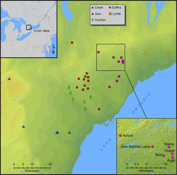
Sequences of village sites have typically been defined by the geographic proximity of settlements in specific drainages (e.g., Birch and Williamson Reference Birch and Williamson2013; Warrick Reference Warrick2008) and regional ceramic type and attribute seriations (e.g., Niemczycki Reference Niemczycki1984; Ramsden Reference Ramsden1977; Tuck Reference Tuck1971), as well as the type and frequency of European trade goods for sites assumed to postdate 1500 (Bradley Reference Bradley1987; Kenyon and Kenyon Reference Kenyon, Kenyon and Hayes1983). Since at least the 1970s (e.g., Ramsden Reference Ramsden1977; Ritchie and Funk Reference Ritchie and Funk1973; Tuck Reference Tuck1971), it has been assumed that village sites within specific stream basins represent the sequential movements of a single community and, in some cases, coalescences of multiple communities (Birch Reference Birch2012; Birch and Williamson Reference Birch and Williamson2013). This assumption has been strongly relied on in southern Ontario, where a series of subparallel, north–south-trending streams drain into the north shore of Lake Ontario. MacDonald (Reference MacDonald2002) suggested that these stream basins formed natural territories that facilitated the separation of communities and their needs for agricultural soils as well as hunting and fishing territories. The single-village relocation model has perhaps been most visible in the West Duffins Creek drainage, where it has been argued that the Draper, Spang, and Jean-Baptiste Lainé (the latter formerly known as Mantle) sites represent sequential iterations of a single aggregated village community (Figure 1; Birch Reference Birch2012; Birch and Williamson Reference Birch and Williamson2013; Williamson Reference Williamson2014; see also Finlayson Reference Finlayson1985). For other village relocation sequences in the Humber, Don, and Trent River systems of southern Ontario, the precise sequence of village relocations is less clear. It is likely that multiple communities occupied each of these drainages contemporaneously (Birch and Williamson Reference Birch and Williamson2013:30–43).
Locations of north-shore village sites used in the social network analysis.

Despite explanatory frameworks based on village relocation sequences, flexibility has always been a defining characteristic of the ancestral Wendat settlement landscape (Birch Reference Birch2015; Birch and Lesage Reference Birch, Lesage, Lamoureux-St-Hilaire and Macrae2020). Population movement, amalgamation, coalescence, dispersal, resettlement, incorporation, and abandonment occurred at the local and regional scales throughout Northern Iroquoian history. In addition to the regular relocation of village-communities, as described above, the short-distance relocation of households and subcommunity groups between villages and the long-distance relocation of those same social units to new regions also occurred. In some cases, household clusters were added to existing villages, and in others, the distribution of nonlocal materials indicates that newcomers were integrated into existing longhouse structures (e.g., Birch Reference Birch2012; Ramsden Reference Ramsden, Keenlyside and Pilon2009, Reference Ramsden2016; Williamson et al. Reference Williamson, Cooper and Robertson1998). Both the ethnohistoric and archaeological records attest to the incorporation of Wendat and non-Wendat peoples into Wendat villages (Ramsden Reference Ramsden2016; Thwaites Reference Thwaites1896–1901; Williamson et al. Reference Williamson, Burchell, Fox, Grant, Loewen and Chapdelaine2016). In these ways, despite the seemingly sedentary nature of Iroquoian village-communities and the regular relocation of villages within drainages, their composition could in fact be rather fluid. Such patterns of local and regional mobility—termed “population circulation”—have been documented in middle-range and urban settlements elsewhere (Bernardini Reference Bernardini, Cabana and Clark2011; Schachner Reference Schachner2012; Smith Reference Smith2014). As such, there is an inherent tension between the reliance on the site sequence model in Iroquoian archaeology and the realities of population circulation and residential flexibility as is evident in settlement pattern data (Birch and Lesage Reference Birch, Lesage, Lamoureux-St-Hilaire and Macrae2020), isotopic data (Pfeiffer et al. Reference Pfeiffer, Williamson, Newton, le Roux, Forrest and Lesage2020), ethnohistoric accounts (Thwaites Reference Thwaites1896–1901), and oral histories (Sioui Reference Sioui1999).
Coalescence, Conflict, and Confederacy Formation
Bayesian modeling of radiocarbon dates from multiple village sequences in south-central Ontario and central New York have recently changed our understandings of the timing and causes of coalescence and conflict in Northern Iroquoia in ways that bear directly on the site sequence model described above. Previously, it had been thought that palisaded sites and human remains bearing signs of violent conflict appeared in southern Ontario in the mid-fifteenth century. It was also thought that conflict occurred primarily between ancestral Huron-Wendat communities in adjacent drainages. In New York, conflict was thought to develop slightly later, in the late fifteenth to early sixteenth centuries, also primarily among adjacent groups (Snow Reference Snow1994). As such, in both regions, the appearance of violent conflict represented the beginning of a new phase or horizon in each region's history. Their asynchronicity—the mid-1400s in Ontario and the late 1400s to early 1500s in New York—gave the impression that early conflict was confined to the local region, with interregional hostilities not emerging until the early contact era.
The new date estimates for Iroquoian site sequences developed by the Dating Iroquoia project (Birch et al. Reference Birch, Manning, Sanft and Conger2021; Manning et al. Reference Manning, Birch, Conger, Dee, Griggs, Hadden, Hogg, Ramsey, Sanft, Steier and Wild2018, Reference Manning, Birch, Conger, Dee, Griggs and Hadden2019) indicate that evidence for conflict first appears in Onondaga and Seneca territory sites in New York and at one contemporary ancestral Huron-Wendat site in the Middle Humber Valley at the west end of Lake Ontario in the late 1400s. Palisaded Huron-Wendat settlements with evidence for violent conflict do not appear further east in the Don Valley and West Duffins Creek Drainages until approximately 1525 (Figure 2). Palisaded settlements also appear to the east in the Trent Valley in the first decades of the 1500s. This suggests that violent conflict came to ancestral Wendake as a wave emanating from the east and west ends of Lake Ontario. The withdrawal of populations off the north shore of Lake Ontario, moving north and east, seems to be in keeping with the formation of a buffer zone along the frontier with the Seneca at the same time confederacy formation was taking place among the Five Nations of the Haudenosaunee. The key finding that bears on this article is that there is no evidence that ancestral Huron-Wendat communities engaged in conflict with one another.
Date estimates and relative contemporaneity of sites in the Humber, Don, and West Duffins Creek drainages.

The recognition that (a) there is no evidence for conflict among Huron-Wendat communities and (b) residential flexibility was a common and recurrent practice among members of ancestral Huron-Wendat society raises questions about the assumptions inherent in the site relocation sequence model. If ancestral Huron-Wendat communities were coalescing in response to external threats—as opposed to conflict with neighboring communities as previously assumed—how does this affect our conceptualizations of site relocation sequences? And, how might social network analysis be brought to bear on this question?
Pottery, Social Network Analysis, and Village Sequences
Although SNA has been in occasional use in North American archaeology for several decades to build understandings of social interactions (e.g., Peregrine Reference Peregrine1991), its use has increased substantially over the past decade (e.g., Brughmans Reference Brughmans2013; Mills Reference Mills2017; Peeples Reference Peeples2019). Social network analyses utilize similarity coefficient matrices, which are often calculated from counts of artifact attributes or types; pottery is most frequently used in late prehistoric contexts in North America (e.g., Lulewicz Reference Lulewicz2019; Mills et al. Reference Mills, Peeples, Haas, Borck, Clark and Roberts2015), although other artifacts—such as shell gorgets (Lulewicz and Coker Reference Lulewicz and Coker2018), lithic technology (Rorabaugh Reference Rorabaugh2019), and lithic raw materials (Hill et al. Reference Hill, Nolan, Seeman and Donnellan2020; Ladefoged et al. Reference Ladefoged, Gemmell, McCoy, Jorgensen, Glover, Stevenson and O'Neale2019)—have been used there and elsewhere. Here, we continue the use of incised and stamped design motifs on the collars of Iroquoian pots as the foundation of our SNA. We acknowledge that other aspects of Iroquoian vessel form, function, and manufacturing technique have been noted to vary in a meaningful fashion (e.g., Curtis and Latta Reference Curtis and Latta2000; Hawkins Reference Hawkins2004; Martelle Reference Martelle2002, Reference Martelle2004) and that the assembly of datasets that consider both high- and low-visibility attributes of ceramic vessels (e.g., Lulewicz Reference Lulewicz2019; Peeples Reference Peeples2018) would be a useful complement to this work.
Iroquoian women were the producers of pottery, and they tended to work in family groups (Perrelli Reference Perrelli, Miroff and Knapp2009). Within the context of these groups, women selected from a corpus of culturally mediated decorative motifs while at the same time expressing their own creativity (Braun Reference Braun2015). These incised and stamped decorations, consisting mostly of combinations of straight lines, had high contextual and absolute visibility (Carr Reference Carr, Carr and Neitzel1995) within the interiors of longhouses—the primary places of pottery use (Chilton Reference Chilton1996). The decorations and collars were unnecessary for the primary functions of Iroquoian pottery—water-based cooking. Collars required additional materials (clay, temper), manufacturing and drying time, time for planning and execution of decorations, and skill for successful firing. As such, collar decorations were costly signals (Bliege Bird and Smith Reference Bliege Bird and Smith2005), conveying to others information about the creators and users of the pots (Hart and Engelbrecht Reference Hart and Engelbrecht2012). They were symbolically generalized communication media, which facilitated information exchange in networks of interaction (Mizoguchi Reference Mizoguchi and Knappett2013).
Ethnoarchaeological research indicates that, in some instances, pottery decorations serve as signals that convey information about women's political activities (Bowser Reference Bowser2000; Bowser and Patton Reference Bowser and Patton2004). This seems apt in Northern Iroquoia where we know from the ethnohistorical record that women were important in political activities (Birch Reference Birch2015). A series of pan–Northern Iroquoian social network analyses have demonstrated that decorative motifs on collars track changes in sociopolitical and settlement systems through time (Hart et al. Reference Hart, Shafie, Birch, Dermarker and Williamson2016, Reference Hart, Birch and St. Pierre2017, Reference Hart, Winchell-Sweeney and Birch2019) and differences in confederacy structures (Birch and Hart Reference Birch and Hart2018), reflecting the importance of women in Iroquoian communities as well as intercommunity relationships and politics.
As summarized by Engelbrecht (Reference Engelbrecht2003:106) following Allen (Reference Allen1988), geographic proximity and pottery similarity are most often used by archaeologists to determine if a series of Iroquoian sites represent a sequence of village removals (see also Ramsden Reference Ramsden1977). Decorations on pottery collars were drawn from a corpus of culturally mediated designs that were readily interpreted by individuals within and outside of a matrifamily, signaling group/network membership. Pottery manufacture was performed by women and taught intergenerationally within matrifamilies. Given the typically short duration of village occupations, women might live in two or three sequential villages during their lifetime. Although women expressed their own skills and ideas in the execution of collar decoration and although external group memberships may have changed over generations, because there was continuity in matrifamilies, we would expect the assemblage of designs from any given village site to be most similar to those from immediately earlier and later sites representing the same community. Similarity in pottery design between villages in different site sequences or clusters might also be interpreted as indicating movement of potters from one community to another.
Methods
All network visualizations were performed in Visone 2.18 (Brandes and Wagner Reference Brandes, Wagner, Jünger and Mutzel2004). Louvain cluster analyses—a community detection method that optimizes modularity, resulting in the best node groupings in the network (Blondel et al. Reference Blondel, Guillaume, Lambiotte and Lefebvre2008)—was also performed in Visone. Other statistical analyses were performed with PAST 4.02 (Hammer et al. Reference Hammer, Harper and Ryan2001) unless otherwise noted in the text. The Brainerd-Robinson (BR) similarity matrix used in the analyses is a subset of the larger matrix published in our previous macroscale analyses (Hart et al. Reference Hart, Shafie, Birch, Dermarker and Williamson2016:S1 Appendix, Reference Hart, Birch and St. Pierre2017:Data Files S1, Reference Hart, Winchell-Sweeney and Birch2019:S1 Appendix). The matrix was calculated in the Similarity and Distance Measures module of TFQA 5.0 from site-assemblage motif category counts using (a) the Monte Carlo pairwise algorithm specifying 1,000 iterations and (b) random seed generated by the clock to adjust for sample size variation (Kintigh Reference Kintigh2010).
AMS radiocarbon dates for the later West Duffins Creek site sequence follow Manning and colleagues (Reference Manning, Birch, Conger, Dee, Griggs, Hadden, Hogg, Ramsey, Sanft, Steier and Wild2018), with the exception of dates from the Best, Pugh, and Aurora sites that were acquired from the Center for Applied Isotope Studies at the University of Georgia and that are reported here for the first time (Table 1). Bayesian analyses of radiocarbon dates were done with OxCal 4.3 (Bronk Ramsey Reference Bronk Ramsey2009a), using various forms of outlier analysis (Bronk Ramsey Reference Bronk Ramsey2009b; Dee and Bronk Ramsey Reference Dee and Ramsey2014; Dee et al. Reference Dee, Wengrow, Shortland, Stevenson, Brock, Flink and Ramsey2013) and the atmospheric IntCal13 calibration curve (Reimer et al. Reference Reimer, Bard, Bayliss, Warren Beck, Blackwell, Ramsey, Buck, Cheng, Lawrence Edwards, Friedrich, Grootes, Guilderson, Haflidason, Hajdas, Hatté, Heaton, Hoffman, Hogg, Hughen, Felix Kaiser, Kromer, Manning, Niu, Reimer, Richards, Marian Scott, Southon, Staff, Turney and van der Plicht2013). Details of the modeling process and OxCal code are provided in Supplemental Tables 1 and 2. We employ capitalized forms of words such as Sequence, Phase, Boundary, Date, and Interval to refer to OxCal Chronological Query Language (CQL2) Command Reference terms.
Radiocarbon Dates Newly Reported in This Study.

Notes: All other radiocarbon dates used in the West Duffins sequence modeling follow Manning and colleagues (Reference Manning, Birch, Conger, Dee, Griggs, Hadden, Hogg, Ramsey, Sanft, Steier and Wild2018). Calibration uses OxCal v.4.3 (Bronk Ramsey Reference Bronk Ramsey2009a) and IntCal 13 (Reimer et al. Reference Reimer, Bard, Bayliss, Warren Beck, Blackwell, Ramsey, Buck, Cheng, Lawrence Edwards, Friedrich, Grootes, Guilderson, Haflidason, Hajdas, Hatté, Heaton, Hoffman, Hogg, Hughen, Felix Kaiser, Kromer, Manning, Niu, Reimer, Richards, Marian Scott, Southon, Staff, Turney and van der Plicht2013).
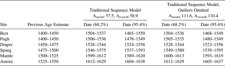
The model includes the Best and Pugh sites as a single Phase, followed in a Sequence by the Draper, Spang, Jean-Baptiste Lainé, and Aurora sites as Phases as per traditional understandings of the local sequence. Date estimates were calculated as a summary of each Phase. The Date function in OxCal determines a hypothetical event describing the temporal extent of the Phase between its start and end Boundaries. We have very few dates for Best, Pugh, and Aurora, but including these sites in the modeling extends the Sequence both earlier and later in time, thereby providing additional context for the local sequence in question. Justification for modeling decisions follows Manning and colleagues (Reference Manning, Birch, Conger, Dee, Griggs, Hadden, Hogg, Ramsey, Sanft, Steier and Wild2018). All dates reported for other sites and sequences outside of West Duffins Creek follow Birch and colleagues (Reference Birch, Manning, Sanft and Conger2021).
Results
Radiocarbon Dating
Modeled Date estimates for radiocarbon-dated sites in the West Duffins drainage are presented in Table 2. These are contextualized by dates from the Humber and Don valley drainages to the east in Figure 2. The earliest villages with defensive palisading occur in the Humber River drainage. Conflict and defensive palisading then spread to sites in the Don and West Duffins Creek drainages after approximately 1525.
Modeled Date Estimates, West Duffins Site Sequence.

Notes: Archaeological assumptions employed in the modeling follow Birch and Williamson (Reference Birch and Williamson2013). Logic employed in modeling follows Manning and colleagues (Reference Manning, Birch, Conger, Dee, Griggs, Hadden, Hogg, Ramsey, Sanft, Steier and Wild2018). See Supplemental Tables 1 and 2 for the OxCal runfiles.
Social Network Analysis
Figure 3a is an SNA visualization of southern Ontario Iroquoian sites dating from 1350 to 1650 utilizing the entire BR similarity matrix. This is the subregional mesoscale in our analysis. In this network, Best, Pugh, Draper, and Spang—the local sequence or microscale—cluster together at the top, whereas Jean-Baptiste Lainé and Aurora plot amid a large number of earlier sites from the Humber, Don, and Credit Rivers to the west at the bottom left. Figure 3b, a strong-ties network for the same sites using BR values ≥153 (85% of 180, the highest value in the network), shows the same pattern. Louvain community detection analysis with initial clustering set to uniform and edge weight set to BR values results in four clusters: within these Best, Pugh, Draper, and Spang are grouped together in one cluster and Jean-Baptiste Lainé and Aurora in another. Absent two isolates in the network used for Louvain analysis, these results are identical to k-means cluster analysis results using the full BR matrix and specifying four clusters (Supplemental Table 3), as well as the results of metric multidimensional scaling (Supplemental Figure 1). In each analysis, Aurora and Jean-Baptiste Lainé cluster with earlier sites to the west, whereas Draper and Spang cluster with Best and Pugh. These results indicate that there was a shift in the use of collar decoration motifs in the sequence between Spang and Jean-Baptiste Lainé, with the community incorporating a greater percentage of motifs previously in use by communities located to the west.
Social network analysis visualizations for north-shore village sites: (a) Backbone visualization using the complete BR matrix; (b) Spring-embedded, strong-ties network using a BR threshold of ≥153 (80% of highest values in the network). Darker ties indicate higher BR values. Node size reflects chronology with the largest nodes representing the youngest sites.

The results of t-tests using vectors of BR values between each of the six West Duffins Creek village sites and village sites dating from 1450 to 1600 in the Humber, Don, and Credit river drainages to the west are presented in Table 3. Permutation p-values are used because of the small sample size (n = 15). Paired t-tests were used under the assumption that each set of chronologically sequential sites (the microscale) represents the same community before and after a relocation, respectively. (Because they are not sequential, a paired test was not performed for Best and Pugh.) Each of the paired tests has a p-value <0.05, indicating a significant difference between the vector means. The vectors of differences between the pairs do not depart significantly from normal distribution (Supplemental Table 4). The results show an increase in vector means between Best and Pugh, followed by decreases for Draper and then Spang, followed by a substantial increase for Jean-Baptiste Lainé and small decrease for Aurora. T-tests were also used with no assumption that the sites represent sequences of the same community. The six vectors do not depart significantly from normal distribution (Supplemental Table 5), and the vector pairs do not have significantly different variances (Supplemental Table 6). The paired t-test pattern is duplicated with the exceptions that there is not a significant difference between Best and Pugh or between Jean-Baptiste Lainé and Aurora.
T-Test Results for West Duffins Creek Sites’ BR Values with North Shore Sites to the West, AD 1450–1600.

Note: Bold indicates the site with the greater mean.
a Exact permutation.
b Monte Carlo permutation.
The E-I index was calculated for the 1450–1650 mesoscale network using Borck and colleagues’ (Reference Borck, Mills, Peeples and Clark2015) R script with 5,000 permutations, and it was normalized for sample size for the 1450–1650 network. This index indicates whether a node within a network is more focused on interactions inside (homophily) or outside (heterophily) of its network group (in this case, the microscale stream basin). Values range from –1 to +1, with negative values indicating homophily and positive values heterophily. Results are presented in Supplemental Table 7. Although all of the indices are positive, there is a drop-off following Pugh, with Spang having the lowest value. The value for Jean-Baptiste Lainé is over four times greater than the value for Pugh, whereas the value for Aurora is slightly higher than that of Jean-Baptiste Lainé.
Taken together, the results indicate that the communities at Jean-Baptiste Lainé and Aurora made greater use of collar decoration signals previously used by communities to the west than did the communities at Draper and Spang. This is consistent with our previous macroscale analysis that indicated less external signaling during the period of regional conflict (Hart et al. Reference Hart, Shafie, Birch, Dermarker and Williamson2016). As is apparent in Supplemental Table 8, the pottery assemblages of sites in the cluster with Jean-Baptiste Lainé and Aurora had high percentages of simple motifs (diagonal or vertical lines), whereas those in the Draper and Spang cluster had lower percentages of simple motifs and higher percentages of crossed motifs (designs with one or more lines crossing at an angle), including sites dating to the fifteenth century. Our earlier analyses (Birch and Hart Reference Birch and Hart2018; Hart et al. Reference Hart, Shafie, Birch, Dermarker and Williamson2016) identified the simple motif category as a metaidentifier for the Wendat confederacy.
Expanding the SNA to the macroscale to include sites to the north in historic Wendake and the adjacent Tionontaté (Petun) area provides additional contexts for these changes (Figure 4). The resulting strong-ties network SNA visualization for the 1450–1650 time frame continues to separate Jean-Baptiste Lainé and Aurora from earlier sites in the West Duffins Creek drainage. Aurora is assigned to the Louvain cluster containing most of the Wendake-Tionontaté sites. The last villages in our sample from the Credit (Emmerson Springs), Don (Keffer, but not Jarrett-Lahmer), and Humber (Diaimani, Seed-Barker, MacKenzie-Woodbridge) cluster with Jean-Baptiste Lainé. This indicates a west-to-east trend in use of the metaidentifier (simple motifs), a signal of membership in a network focused to the north. This shift in signaling network is evident in paired Wilcoxon and Mann-Whitney tests of the West Duffins Creek sites’ BR values with Wendake-Tionontaté sites dating to 1450–1650 (Table 4). These nonparametric tests were used because the vectors of Wendake-Tionontaté BR values depart significantly from normal distribution (Supplemental Table 9). A significant shift in BR values occurs between the occupations of Spang and Mantle.
A stress-minimization, strong-ties network visualization of north-shore and Wendake-Tionontaté village sites dating between 1450 and 1650 using a BR threshold of ≥164 (80% of highest values in the network). Darker ties indicate higher BR values.

Wilcoxon and Mann-Whitney Tests of BR Wendake-Tionontaté Site 1450–1650 Vectors for West Duffins Creek Sites.

Note: Sites with bolded name have higher medians (W) or mean rank (U).
a Monte Carlo permutation.
By the time Jean-Baptiste Lainé and Aurora were occupied, other drainages to the west had been abandoned, with the exception of the Upper Humber drainage where the Skandatut site is located. Although Skandatut's decorated pottery collar assemblage is not large enough to be included in the SNA analysis, the 3.2 ha site is unlikely to have accommodated the multiple communities of villages abandoned after 1580 in the Upper Humber drainage and to the west. Even though the abandonment of villages from the west may have resulted, in part, due to functional reasons for village relocation (limitations of soil fertility, firewood, etc.), it now seems far more likely that this pattern of population movement had more to do with the expansion of a buffer zone on the frontier of escalating conflicts with the Seneca and the larger Haudenosaunee confederacy (Birch et al. Reference Birch, Manning, Sanft and Conger2021).
The strong ties between Jean-Baptiste Lainé and Aurora and multiple villages in the drainages of the Don, Humber, and Credit Rivers indicate that signaling behavior employed at these earlier sites was now taking place at Mantle and Aurora. This is in keeping with the increasing and widespread use of metaidentifiers at the mesoscale. Approaching these patterns from the microscale causes us to rethink the composition of these communities, including the possibility that these villages may have been refugia for subcommunity groups fleeing hostilities to the west.
Although little is known about the internal structure of the Aurora site (but see Emerson Reference Emerson1954), we know a great deal about Jean-Baptiste Lainé's occupational history (Birch and Williamson Reference Birch and Williamson2013). The village was originally constructed with longhouses arranged in a radial alignment surrounding a plaza that also contained a number of lightly built, temporary structures (Figure 5). Partway through the site's occupation, two major changes occurred: the palisade was contracted and reinforced with the addition of a ditch and earthen embankment, and the plaza was filled in with new, permanent structures. The contraction of the palisade has been thought to have coincided with a portion of the population leaving the village, possibly relocating to sites further north, including Aurora. Aurora's palisade also features the same ditch-and-embankment structure (Emerson Reference Emerson1954). The results of this network analysis offer an additional dimension to our understanding of the Jean-Baptiste Lainé site's occupational history. It now seems likely that Jean-Baptiste Lainé and Aurora were home to people with deep roots in the local drainage as well as people originating to the west who were relocating north and east, away from the frontier with the Seneca (Birch et al. Reference Birch, Manning, Sanft and Conger2021). The reconfiguration of the Jean-Baptiste Lainé site plan, including the in-filling of the plaza with new structures, may have been because of the inflow of people from outside the local sequence. Previous analyses of the Jean-Baptiste Lainé site have also recognized diversity in artifact assemblages and mortuary behavior, suggesting that Jean-Baptiste Lainé was more cosmopolitan than earlier communities in the north-shore region. Notably, strontium isotope analyses of human tooth enamel indicates the presence of individuals who originated from outside the region (Pfeiffer et al. Reference Pfeiffer, Williamson, Newton, le Roux, Forrest and Lesage2020). This may have been in part because Jean-Baptiste Lainé and Aurora were among the last remaining communities on the Haudenosaunee frontier, and as such, they exhibit the characteristics of communities situated on frontiers or borderlands (e.g., Harry and Herr Reference Harry and Herr2018). Aurora's strong ties to sites in the historic Wendake-Tionontaté homelands can be interpreted as relating to the eventual amalgamation of this community into the confederacy with the final abandonment of the north-shore region.
Jean-Baptiste Lainé site plan composite. The gray circle indicates the plaza area that was a feature of the original village plan before being filled in with lightly built and then permanent structures. For a thorough description of the Jean-Baptiste Lainé site excavations and occupational history, see ASI (2014) and Birch and Williamson (Reference Birch and Williamson2013).

Conclusions
The new radiocarbon time frame for late precontact Iroquoia makes it clear that conflict between Haudenosaunee and ancestral Wendat communities was the impetus for the coalescence of settlements on the north shore of Lake Ontario as well as the relocation of these same communities northward along major drainages during the late fifteenth and sixteenth centuries AD. The data and interpretations presented here reveal a new dimension to site relocation sequences and processes of population movement.
Whereas it was previously thought that coalescence had been occurring primarily among local community groups throughout this period, the SNA analyses conducted here indicate that this was only the case initially—that is, in the mid-sixteenth century. Over the next 50-year period, as conflict and the withdrawal of ancestral Wendat populations north and east continued, the use of metaidentifiers and the fission and fusion of subcommunity groups contributed to both network topologies at the mesoscale and coresidential communities at the microscale that were more dynamic than the single-village relocation sequence model permits. Similar results have been obtained in a recent assessment of a proposed three-village sequence in the late fifteenth- to sixteenth-century Mohawk River valley in New York (Hart Reference Hart2020).
By applying new analytical techniques to archaeological data—in this case, derived from extant collections—studies such as this one are causing us to rethink long-held assumptions about the cultural past (Wylie Reference Wylie2017). Bayesian modeling of radiocarbon dates and social network analysis of pottery decoration have resulted in the recognition that ancestral Wendat settlement dynamics were more variable than previous models of site relocation sequences or local processes of coalescence have suggested. These findings are also in keeping with ancestral Wendat understandings about the nature of circular relations between their communities and the centrality of processes of incorporation in ancestral Wendat society (Sioui Reference Sioui1999).
Acknowledgments
Thanks to Susan Winchell-Sweeney for drafting Figure 1. We also acknowledge our collaborators on the social network analyses and radiocarbon dating projects that laid the foundation for this work. Thanks to the Huron-Wendat Nation for the opportunity to learn more about the lives of its ancestors.
Date Availability Statement
Original radiocarbon data are identified in text. No other original data were presented in this article.
Supplemental Materials
For supplemental material accompanying this article, visit https://doi.org/10.1017/aaq.2021.5.
Supplemental Figure 1. Metric multidimensional scaling (principal coordinates analysis) plot of north-shore village sites BR matrix with minimal spanning tree and eigenvalue scaling, and no transformation exponent.
Supplemental Table 1. West Duffins Sequence Traditional Model Runfile.
Supplemental Table 2. West Duffins Sequence Traditional Model with Outlier Samples with Agreements <60 Omitted.
Supplemental Table 3. Cluster Analyses Results of All Southern Ontario Sites in the SNA Database.
Supplemental Table 4. Tests for Normal Distribution of BR Vector Differences between West Duffins Creek Sites and Sites to the West Dating from 1450 to 1650.
Supplemental Table 5. Test for Normal Distribution for BR Vectors between West Duffins Creek Sites and Sites to the West Dating from 1450 to 1650.
Supplemental Table 6. F-Test Results for BR Vectors Pairs between West Duffins Creek Sites and Sites to the West Dating from 1400 to 1650.
Supplemental Table 7. E-I Index Results for North-Shore Sites.
Supplemental Table 8. Percentages of Simple and Crossed Motifs by Site within SNA Clusters.
Supplemental Table 9. Normality Tests for West Duffins Creek 1450–1650 Wendake-Tionontaté Site BR Value Vectors.