INTRODUCTION
Archaeologists have long debated how the emergence of core polities prompts changes in the settlement patterns of peripheral regions. It is argued that the emergence of ancient states led to the expansion of their territories outside their heartlands to secure a stable subsistence base for their core region and improve access to exotic prestige goods used to legitimize the status of elites (Algaze Reference Algaze1993; Morris 1998; Jennings and Craig Reference Jennings and Craig2001; Sherman et al. Reference Sherman, Balkansky, Spencer and Nicholls2010; Spencer Reference Spencer2010). Expansive political processes normally brought significant socio-political changes to the peripheral regions. In various case studies, warfare, patronage claims, control of ritual rites, and unequal balances of trade are cited as catalysts for such changes, and those strategies were applied to each region variously according to the political, social, economic, and geographical relationships between the core and peripheral polities (Feinman et al. Reference Feinman, Kowalewski, Finsten, Blanton and Nicholas1985; Feinman and Nicholas Reference Feinman and Nicholas1990; Chase-Dunn and Hall Reference Chase-Dunn and Hall1991; Schreiber Reference Schreiber1992; Algaze Reference Algaze1993; Liu Reference Liu1996; Balkansky Reference Balkansky1998; D’Altory et al. Reference D’Altroy, Lorandi, Williams, Calderari, Hastorf, DeMarrais and Hagstrum2000; Jennings and Craig Reference Jennings and Craig2001; Bauer and Covey Reference Bauer and Covey2002; Caballo Reference Caballo and Pluckhahan2007). Those interregional relationships caused the rearrangement of local settlements, colonization of new areas internal development around the capitol, and the establishment of depopulated buffer zones between major rivals (Bauer and Covey Reference Bauer and Covey2002), which are reflected in different archaeological site distribution patterns.
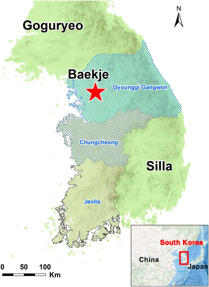
In Korean archaeology, the emergence of ancient states and their territorial expansions are the subject of intense scrutiny. According to Korean and Chinese historical records (Chen Reference Chen2007 [late 3rd century]; B. Kim Reference Kim1998 [1145]), three early states, Baekje, Goguryeo, and Silla, occupied the Korean peninsula from the 1st to 7th centuries AD. Baekje, whose first capitol was located in the Han River basin in today’s Seoul, began as one of 54 small polities, called “Mahan,” that occupied the southwestern Korean peninsula and grew to become an ancient state by conquering or merging other polities and eventually spread its territory over the present-day Gyounggi, Gangwon, Chungcheong, and Jeolla provinces (Figure 1). By the late 3rd century, Baekje had royal cemeteries, and city walls in its heartland, which are viewed by archaeologists as indices of ancient statehood (Park Reference Park2001). From the 4th century, Baekje started to expand its territory over its heartland in earnest, which is evidenced by the spread of Baekje-style artifacts into other regions (Kim Reference Kim2006; Park Reference Park2007).
Research area and location of early ancient states in South Korea in the 4th century AD. The research area is divided into three subregions: Gyounggi-Gangwon, Chungcheong, and Jeolla.

Although territorial expansion of Baekje after the 4th century AD is evident from historical records and archaeological data, the mechanisms of the expansion are not yet fully understood. Several studies suggest that Baekje must have interacted with peripheral polities in various ways, which must have resulted in diverse changes in each region (Seong Reference Seong2000; Park Reference Park2007). Therefore, interactions between the Baekje state and its peripheral polities during the expansion period can provide the basis for comprehending the growth and consolidation of Baekje’s power and state formation and consolidation processes, more generally. Here, by investigating changes in the settlement distribution across the Korean peninsula before and after the development of Baekje state, territorial expansion is shown to have initiated variable responses in settlement organization across the region. Using radiocarbon (14C) dates and GIS analysis, changes in population concentrations and site distribution patterns are compared across the southwestern Korean peninsula both before and after AD 300, when Baekje is argued to have become a state (Seong Reference Seong2000; Kim Reference Kim2006; Park Reference Park2007).
METHODS
Over the past two decades, archaeologists have been using distributions of 14C dates as proxies for demographic changes (e.g., Gamble et al. Reference Gamble, Davies, Pettitt, Hazelwood and Richards2005; Kuzmin and Keates Reference Kuzmin and Keates2005; Rick Reference Rick1987). Temporal change in the density of 14C dates, for example, is used to infer population change over time. Some archaeologists employ changes in spatial distribution of 14C dates as a means of detecting migration or the emergence of population centers (Shennan and Edinborough Reference Shennan and Edinborough2007; Seong Reference Seong2009; Manning and Timpson Reference Manning and Timpson2014; Chaput et al. Reference Chaput, Kriesche, Betts, Martindale, Kulik, Schmidt and Gajewski2015). An assumption of these approaches is that the density of 14C dates represents the intensity of human activities, if the sample size is reasonably large, the datasets are well controlled and sampling biases are removed. In this paper spatial distributions of 14C dates are compared from archaeological sites in the southwestern Korean peninsula before and after AD 300 to detect whether there were changes in settlement distribution and population reorganization.
Dataset and Bias Control
Compared to other areas, South Korea provides an exceptionally good opportunity to develop a probabilistic understanding of settlement distributions using 14C dates because the intensity of archaeological excavations is high resulting in a robust dataset. Due to large-scale infrastructure development since the 1990s, cultural resource management investigations in the form of full-scale excavations of archaeological sites have been frequent and widely distributed across the country. The locations of modern Korean cities overlap with archaeological sites due to the mountainous terrain and limited availability of arable land.
Archaeological site information was obtained from published data recovery reports submitted to the Cultural Heritage Administration in the Ministry of Culture, Sports and Tourism of South Korea. From each archaeological site, we chose dates from pit houses, rather than other features such as ditches, fields, burials, storages and middens, to avoid overestimation of population size. When multiple dates were reported from an individual house, we statistically combined them using the R_Combine script available in the OxCal 4.2 package (Bronk Ramsey Reference Bronk Ramsey2009). A total of 1357 dates were collected from 279 archaeological sites (see Supplementary Materials 1 and 2 for site distribution and Supplementary Material 3 for 14C dates).
But to use frequency of 14C dates as a proxy for population, another bias must be addressed. The total number of houses excavated in the study area is 8859 and the total number of dated houses is 1357 (15.3%). Despite this large sample size and sample fraction (i.e., the ratio of dated to undated houses), the spatial and temporal distribution of 14C dates may still be biased due to some practical reasons such as budget, research interests of investigations, different preservation of datable materials. For example, only 20 houses could be dated out of 100 houses found at one settlement, while 30 out of 35 houses could be dated at other settlements. A key to mitigating such uneven sampling is to predict dates of undated houses in each settlement, so that dataset reasonably represent the spatiotemporal distribution of population.
Bootstrap resampling, a nonparametric method for inferring population from sample data (Efron and Tibshirani Reference Efron and Tibshirani1993), was adopted to deal with this bias resulting from differential sample fractions of settlements. For settlements with five or more dated houses, we resampled dates at the individual settlement, using the original dates as prior information. At each settlement, the number of dates resampled equals to the total number of houses found at the settlement. Using “Resampling Stats Add-in for Excel” (version 4), the simulation was run ten times at each site and the results were summed. The new dataset consists of 70,170 dates from 181 settlements (See Supplementary Material 4). We believe that this dataset is a more realistic approximation of spatiotemporal distribution of 14C dates than original dataset.
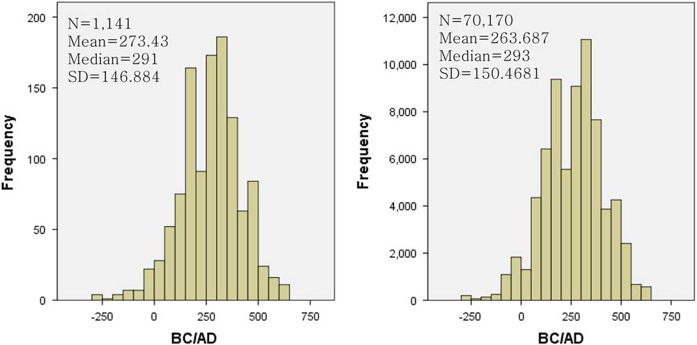
In this case, the original and simulated datasets do not show significant differences in the histogram distribution (Figure 2). T-tests were generated in SPSS Statistics 22.0 on the two sets of samples and determined that the means of the two datasets differ significantly (p<0.00), however this difference is interpreted as the result from very large sample sizes of our datasets as previous parametric statistical studies have demonstrated (e.g., Cohen Reference Cohen1990; Chatfield Reference Chatfield1995). Wald-Wolfowitz runs test, a nonparametric alternative to the t-test for independent samples (Friedman and Rafsky Reference Friedman and Rafsky1979), shows that non-bootstrapped and bootstrapped datasets do not differ in distribution relative to the median value of 14C date (p=1).
Distribution of calibrated median dates: (left) original dataset; (right) simulated dataset.

Since the purpose of this study is to compare spatial distributions of houses before and after AD 300, determining how individual dates relate to this threshold was a critical component of the study. To accomplish this, median dates were used to sort houses into the two periods and were calculated using IntCal13 (Reimer et al. Reference Reimer, Bard, Bayliss, Beck, Blackwell, Bronk Ramsey, Buck, Cheng, Edwards, Friedrich, Grootes, Guilderson, Haflidason, Hajdas, Hatté, Heaton, Hoffmann, Hogg, Hughen, Kaiser, Kromer, Manning, Niu, Reimer, Richards, Scott, Southon, Staff, Turney and van der Plicht2013) in OxCal 4.2 (Bronk Ramsey Reference Bronk Ramsey2009). There is no bias in the statistical sorting of the data since instances in which houses are erroneously designated pre-AD 300 or post-AD 300 have an equal chance of sorting into either bin.
Spatial Analysis
For the spatial analysis, the southwestern part of Korea was divided into three subregions: Gyounggi-Gangwon, Chungcheong, and Jeolla provinces according to their distances from the Baekje core area. All sites were plotted as x, y coordinates in a spatial database.
Using the point data, a series of spatial statistics were generated from the ArcGIS 10.2 package. First, we used kernel density estimates (KDEs) of the number of bootstrap-simulated pit houses both before and after AD 300 to compare population distributions. Because the Wald-Wolfowitz runs test demonstrated perfect parity between the bootstrapped and non-bootstrapped datasets relative to the median age, the bootstrapped data were used in the KDE in order to compensate the imbalance in the ratio of dated houses among settlements and enhance the visual spectrum of the raster map. KDEs convert relative concentrations of point data into raster maps and are used to visualize spatial distributions of clustered data along a gradient. In archaeology, KDEs have been used to show spatio-temporal changes in artifacts or sites (Chaput et al. Reference Chaput, Kriesche, Betts, Martindale, Kulik, Schmidt and Gajewski2015; Grove Reference Grove2011). By visualizing concentrations of pit houses, relative population concentrations were modeled in this study as they changed through time and space. The KDEs visualize the relative densities of the point data, but because the input data differ for each analysis, the visualized density distributions are not directly comparable in terms of absolute values. Nonetheless, the KDEs provide an important tool for clearly observing changes in the spatial distribution of points between the two analyzed time periods, and the KDE values provided in the legend allow for estimating how pronounced the differences in densities are. To define boundaries, masks were set with a shapefile of each analytical unit as Gyounggi-Gangwon, Chungcheong, and Jeolla, and the cell sizes for the KDE were 489.64 m2, 489.17 m2, and 518.26 m2, respectively, following the maximum of input.
Second, spatial autocorrelation analyses were performed to examine how the settlement distributions changed after AD 300 compared to before AD 300. The exclusion of sites with fewer than five 14C ages in the bootstrapped data would not significantly affect the KDE, but spatial autocorrelations are sensitive to statistical outliers (Anselin Reference Anselin1995; Fortin Reference Fortin1999; Anselin et al. Reference Anselin, Syabri and Kho2006). Therefore, we used the locations of 279 sites that have at least one 14C date to examine site distribution patterns.
The first spatial autocorrelation method used was Ripley’s K, which examines clustering patterns at multiple scales of distance. Ripley’s K analysis evaluates the degree to which points demonstrate clustering or dispersion against permutations of random points at increasing scales by calculating the average cumulative frequency of points at a given radius over a range of distances (e.g., Winter-Livneh et al. Reference Winter-Livneh, Svoray and Gilead2010; Wright et al. Reference Wright, MacEachern and Lee2014, Reference Wright, Grillo and Soper2016). K represents the threshold above which clustering occurs and below which dispersion occurs, and K itself represents a completely random distribution of points within the defined spatial parameters of the analysis. The confidence envelope represents the results of Monte Carlo simulations of data distributions given identical spatial parameters and numbers of points. For this analysis, the number of distance bands was set at 60 increasing in 1000-m increments from 0 m with a computed confidence envelope of 999 permutations.
Next, to help with the interpretation of the results of the Ripley’s K analysis, both average nearest neighbor and Global Moran’s I analyses were used. The average nearest neighbor is calculated based on the physical distance between corresponding nearest points within the universe of point data (Wong and Lee Reference Wong and Lee2005; Fletcher Reference Fletcher2008). The result shows the mean distance between all of the points, which in this case corresponds to site settlement distances in the central and southwestern Korean peninsula. The higher the z-score is over zero indicates increasing tendency of the data toward dispersion, while the lower z-score is under zero indicates the relative degree of clustering, and a z-score of zero indicates a completely random distribution of points. Distance calculations were made on the basis of Euclidean distances, and the study area was 28,556 km2 for Gyounggi-Gangwon, 16,327 km2 for Chungcheong, and 20,933 km2 for Jeolla.
But because of its characteristic of calculating average values, this method could be affected by statistical outliers, particularly from anomalously remote sites (Hodder and Orton Reference Hodder and Orton1976; Conolly and Lake Reference Conolly and Lake2006). Therefore as a supplementary metric, Global Moran’s I analysis was also used. This method measures the clustering of similar attribute values in each raster cell. In this study, Moran’s I shows whether the pit house distributions are spatially clustered or not as each site point in the respective period is counted as “1”. To apply Moran’s I, a 2500×2500-m grid was created using the Fishnet tool in ArcGIS 10.2 to make a polygon for Moran’s I and point data were spatially joined to grid cells, following the method used by Fletcher (Reference Fletcher2008). As input data, we used raw counts of sites in each cell, and the data conceptualization used an inverse-distance parameter. The distance threshold was set at 5591 m for Gyounggi-Gangwon, 5591 m for Chungcheong, and 2500 m for Jeolla.
RESULTS
Kernel Density Estimates
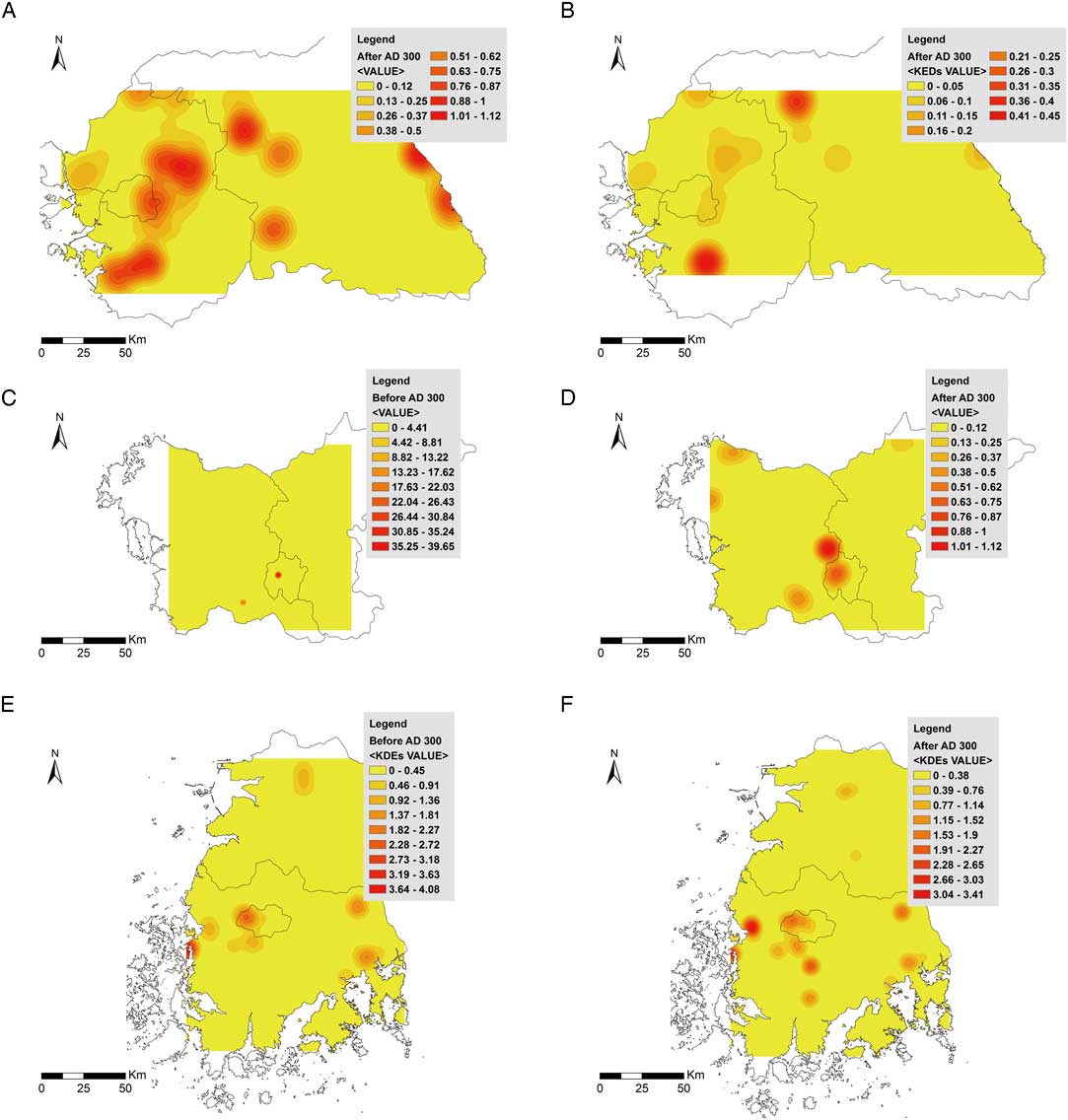
The KDEs show changes to the patterns of population concentrations in each region before and after the 4th century AD (Figure 3). Before AD 300, high population densities were distributed evenly throughout the entire Gyounggi-Gangwon region, and after AD 300 century, population clusters appear limited to the southern part of the study area and some specific parts of the northern area (Figure 3a, 3b). In the case of Chungcheong, the densely populated areas were found in three specific points before AD 300, and after AD 300, population clusters were more widely distributed across the region (Figure 3c, 3d). On the other hand, existing populated areas in the Jeolla area continued expanding in size and new clusters appear across the southern portion of the region (Figure 3e, 3f).
Results of kernel density estimates: (A) Gyounggi-Gangwon before AD 300, (B) Gyounggi–Gangwon after AD 300, (C) Chungcheong before AD 300, (D) Chungcheong after AD 300, (E) Jeolla before AD 300, (F) Jeolla after AD 300.

Spatial Autocorrelation Analyses
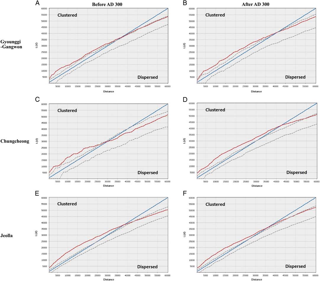
The Ripley’s K analysis shows clustering patterns across all three regions under the 40 km distance band and demonstrates random, then dispersed patterns at some point between 30 to 40 km, crossing the expected K line of random distribution of points (Figure 4). But specific details are slightly different among the regions. In the Gyounggi-Gangwon and Jeolla regions, there are almost no differences between the scales of clustering patterns before or after AD 300, or even between each other. However, the Chungcheong region shows a clustering pattern at a significantly larger scale in the later period compared to the earlier period. These results seem to confirm the KDE that more clustered settlements appear in the later period in Chungcheong compared to the earlier period, but indicate that clustering patterns in Gyounggi-Gangwon and Jeolla provinces remained consistent between the two periods.
Results of Ripley’s K: (A) Gyounggi-Gangwon before AD 300, (B) Gyounggi-Gangwon after AD 300, (C) Chungcheong before AD 300, (D) Chungcheong after AD 300, (E) Jeolla before AD 300, (F) Jeolla after AD 300. The blue line represents the predicted values, the red line represents the actual values analyzed and the dotted lines represent the 2σ confidence envelope. If the red line lies above the blue line, it indicates a clustering pattern. On the other hand, if the red line lies below the blue line, it indicates that the points are dispersed. (Colors refer to online version.)

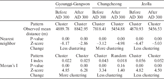
The average nearest neighbor and Moran’s I analyses demonstrate further dimensions of the changing population settlement dynamics (Table 1). First, the nearest neighbor analysis indicates clustering of settlements across the entire area and throughout the whole period, but the details between the regions vary. In the case of the Gyounggi-Gangwon region, z-scores after AD 300 are greater than before AD 300, showing a relatively weaker tendency toward clustering. The mean distance between settlements increases to 4000 m, which is about twice than that of before AD 300. On the other hand, the z-scores of Chungcheong decrease, indicating more clustering, and average distance decreases by 2500 m. Like the Gyounggi-Gangwon region, the results from Jeolla show less clustering based on z-scores, but the average distances only increase by 600 m.
Results of the spatial autocorrelation analysis.

The results of the Moran’s I analysis also generally show clustering, except for in the Chungcheong region after AD 300. But the results are more nuanced from that of the nearest neighbor analysis. The Gyounggi-Gangwon region, in particular, shows a more clustered pattern after AD 300, which is contrary to the results of the nearest neighbor analysis. These results can be explained by an increasing number of sites dated after AD 300 in specific locations. The Chungcheong region shows clustering patterns before AD 300 and a random pattern after AD 300, which is also contrary to the results of the nearest neighbor analysis, suggesting a dispersal of human archaeological activity into a random distribution in the later period. In the case of Jeolla, the patterns before and after AD 300 demonstrate similar degrees of clustering.
DISCUSSION
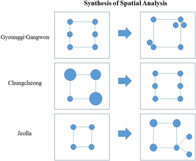
The results of the two spatial autocorrelation analyses may seem contradictory, but these nuanced results arise from the different ways each method estimates clustering, as described above. The two clustering analyses demonstrate that in the Gyounggi-Gangwon region, settlements locations were dispersed after AD 300, but there was local clustering of sites at each primary settlement location. This change is taken to mean that after the expansion of Baekje, dispersed population distributions in Gyounggi-Gangwon started to aggregate, which might have been used as the political, economic and ceremonial centers of the kingdom. The regional population center also shifts southward, which is a likely reaction to the invasion of the Han River basin by the Gorguryeo Kingdom to the north. In Chungcheong, settlement locations are in closer proximity to one another beginning in the 4th century, but the distribution of sites becomes more random or dispersed overall, which indicate reorganization of the population in previously centralized areas to a less clustered settlement pattern. In Jeolla, no significant differences were detected before and after the 4th century, except that settlements were slightly less clustered after the 4th century, which suggests that there was no direct political impact of the Baekje core area on the settlement patterns of this region. In order to synthesize all the spatial analyses, a conceptual illustration of these patterns is provided in Figure 5.
Illustration of settlement changes in each region synthesizing the spatial analysis.

Studies of settlement during the development of Baekje state have focused only on the fixed distribution of settlements within the entire period (Kwon Reference Kwon1988; Seong Reference Seong2000; Park Reference Park2001, Reference Park2007; Kim Reference Kim2006; Lee Reference Lee2011; Lim Reference Lim2011). Previous analyses did not evaluate the potential for dynamic changes in settlements in terms of size and distribution within Baekje’s borders, and limited research was conducted to determine whether these areas were included in Baekje’s territory based solely on the presence or absence of artifacts originating from the Baekje heartland. By using spatial analyses with GIS spatial statistics and 14C dates, a more nuanced pattern of settlement change is now apparent. Regional dissimilarities in settlement patterns evident within the Baekje sphere of influence before and after the 4th century cannot be fully explained by a singular settlement distribution model or by a monotonic expansion of Baekje over southwestern Korea.
The spatially and temporally dissimilar patterns of settlement change identified using spatial statistical tools are interpreted as deriving from the different types of relationships forged between Baekje and peripheral polities and diverse responses of outlying regions to the influence of Baekje as an expansive state. Through combined application of spatial analyses, relative degrees of settlement clustering before AD 300 were different in each region. In Gyounggi-Gangwon, population concentrations were relatively evenly dispersed in the whole region, but in Chungcheong and Jeolla, densely populated areas were more restricted to a limited number of discrete areas. By comparing those patterns, it can be inferred that each community or polity that occupied settlement sites in each area had different population sizes, degrees of political complexity, social structures and affinities with each other, as well as their distance from the Baekje core area. Therefore, the expansion strategies and relationship between Baekje and other polities must have been diverse according to various relational circumstances such as alliances, subjection, confrontation, violence, etc. Also, according to each core-periphery dynamic, the relative degree to which the Mahan polities in different regions were impacted by their relations with Baekje and the nature of their responses to the central polity must have been diverse. As a result, those diverse relationships created a template from which processes of population and settlement redistribution occurred after AD 300 vis-à-vis dissolution, reduction or expansion of existing centers and the emergence of new centers. Although specific causes and effects of population redistribution according to specific regions are beyond the scope of this paper, the three areas analyzed in this study demonstrate differential shifts in population distribution according to the relative distance to the political core of Baekje and the ability of the central polity to exercise political control over the periphery.
Environmental factors cannot be excluded as influential in impacting past settlement decisions. Several studies in Korea have suggested that colder temperatures in the 2nd to 3rd centuries AD had adverse effects on agriculture and forced increased dependence on marine resources after which temperature and sea level rises pushed populations from coastal areas inland (Seo Reference Seo2000; Kim Reference Kim2007; Lim Reference Lim2011). But these studies only propose the possibility of site location changes based on evidence of local environmental conditions of Jeolla coastal areas; there has been no conclusive evidence to this point demonstrating drastic changes in environmental conditions between the different regions. Considering the context of this period and absence of spatially representative paleoenvironmental records, political factors are provisionally interpreted as providing the largest impacts on the variable redistribution of populations and settlement patterns in each of the three regions.
CONCLUSION
14C dating has contributed greatly to archaeology. As a scientific dating technique, it has enabled archaeologists to reevaluate old chronologies that were previously based only on relative dating such as cross-correlated pottery typologies (Bruins and van der Plicht Reference Bruins and van der Plicht2001; van der Plicht and Bruins Reference van der Plicht and Bruins2001; Harunari et al. Reference Harunari, Fujio, Imamura and Sakamoto2003; Levy and Higham Reference Levy and Higham2005; Friedrich et al. Reference Fredrich, Kromer, Friedrich, Heinemeier, Pfeiffer and Talamo2006; Bronk Ramsey et al. Reference Bronk Ramsey, Dee, Rowland, Higham, Harris, Brock, Quiles, Wild, Marcus and Shortland2010; Kim and Kim Reference Kim and Kim2016). In many areas of the world where culture chronologies were constructed on the basis of historical texts or ceramic seriation, 14C dates now provide the basis for challenging deeply entrenched paradigms (Choi et al. Reference Choi, Lee, Lee and Kim2017). However, 14C dates can be used for more than just providing site chronologies. When relevantly controlled and analyzed, 14C dates are effective tools for resolving macro-scale archaeological questions that have not been answered via traditional approaches. In this paper, 14C dates from the southwestern Korean peninsula have been used to examine the spatial reorganization of settlements during the emergence and expansion of the state of Baekje.
Using spatial analyses of settlement sites with 14C dates, we show that various changes in settlement distribution patterns were prompted by the emergence of Baekje state. Results of our analysis suggest that those differences come from diverse socio-political conditions in each region and different relationships between Baekje and other polities according to those conditions. In the case of the Gyounggi-Gangwon region after AD 300, densely populated areas were more spatially restricted and clusters of settlements were distantly separated from one another. But in the Chungcheong region, pre-4th century populated areas dissolved in the later period, and new areas were settled with sparser populations compared to the previous period. Jeolla had relatively stable patterns, showing spatially and temporally continuous population concentrations between the two periods. Although why these differences took shape is beyond the scope of this study, our analysis may provide a clue to a further explanation of relationships between core and periphery and their sociopolitical strategies during the development and expansion of early states.
ACKNOWLEDGMENTS
This work was supported by a National Research Foundation of Korea Grant (NRF-2016S1A5B6924370). Special thanks to Matthew Conte for copyediting an early draft of this paper and two anonymous reviewers for valuable comments. We also thank the organizers of the 14C & Archaeology, 8th International Symposium for the opportunity to present our research from which this paper was drafted.
SUPPLEMENTARY MATERIAL
To view supplementary material for this article, please visit https://doi.org/10.1017/RDC.2017.93