


Introduction
A knowledge of pack ice thickness is vital for studying pack ice dynamics (Reference HiblerHibler 1979) and its impact on the environment (Reference Weller, Carsey, Holt, Rothrock and WeeksWeller and others 1983). Since in situ or remotely sensed measurements of pack ice thickness are not routinely available for the polar oceans, a method to estimate thickness of open pack ice floes, drifting in a marginal ice zone (MIZ), is suggested. The estimates are obtained by solving a reduced form of the general equation of motion for drifting pack ice, using data from four readily available sources. The estimates are obtained by four steps:
-
(a) Estimating the surface wind speed.
-
(b) Estimating the angle of sea ice deflection.
-
(c) Estimating three ratios between ice parameters.
-
(d) Estimating the lower and upper limits of pack ice thickness.
The method has been applied to six groups of open pack ice floes drifting in the MIZ of the Beaufort Sea during 1973–75.
Estimating Open Pack Ice Thickness
The general equation of motion for drifting pack ice (Reference CampbellCampbell 1965) may be reduced to a simple steady state equation of motion if applied to weekly drifts of open pack ice, since impact of ocean currents on pack ice drifting in the Beaufort Sea is negligible for weekly drifts (Reference Feldman, Howarth and DaviesFeldman and others 1981). In this equation, wind stress, water drag and the horizontal Coriolis force per unit area of ice are assumed to be at equilibrium. If a Cartesian coordinate system, in which +x is chosen to be the direction of ice motion, is employed then wind stress is always positive, -x is direction of water drag and -y is direction of the Coriolis stress. The x and y components of this equation are written as:

and

where ρa is air density, Ca is drag coefficient at the air/ice interface, U is horizontal wind speed at 10 m above the ice surface, Δ
y
is the angle of sea ice deflection, ρw (= 1.03 103 kg m−3) is ocean water density,
 is drag coefficient at the water/ice interface, V is speed of center of gravity of a group of open pack ice floes, ρice (= 0.91 103 kg m−3) is ice density, ω (=7.292 10−5 s−1) is Earth’s angular speed of motion, Φ is latitude and h is mean thickness of a group of open pack ice floes.
Position of ice floes has been measured from 1 : 1 000 Landsat-1 MSS images, by a Ruscom digitizer, using control points located on land. Assuming linear motion for the floes, during a two-day sequence, accuracy of positional measurements is ±100 m. Hence, errors in position may vary between ±0.25 and 5% relatively to the motion of the center of gravity of a group of ice floes. Location of ice floes drifting away from land may be determined by means of space triangulation. Errors of ice velocity are identical to errors in position, since temporal data are highly accurate.
Means of Φ in Equation (2) have been determined for groups of drifting open pack ice from Landsat-1 MSS images. V in equations (1) and (2) has been derived for the intermediate scanning time t11i+1 (=t12, t23, t34) from two-day sequences of sidelapping Landsat-1 MSS images, scanned at ti and ti+1 respectively. ρa in equations (1) and (2) has been derived and time adjusted to t11i+1 by means of linear interpolation from two-day sequences of six-hour surface weather charts. Estimates of U in Equations (1) and (2) have been obtained for t11i+1 from the geostrophic wind speed G by the formula of Reference Feldman, Howarth and DaviesFeldman and others (1979). Values of G have been derived and time adjusted to t11i+l by means of linear interpolation from two-day sequences of six-hour, surface weather charts. Estimates of Δ
y
in equations (1) and (2) have been obtained for following the work of Reference Feldman, Howarth and DaviesFeldman and others (1981). The variables h,
 and
cannot be derived from the available data. Hence, they must be estimated.
To determine the ratios M, N and B, Equation (2) has been rewritten as

Equation (1) has been written as

and B, defined from (3) and (4), has been written as

The observed minimum and maximum of h,
and
(Table I), summarized by Reference Feldman, Howarth and DaviesFeldman and others (1981) from previous observations, have then been employed to rewrite Equation (5) as
Extreme Values of h,
and


Equation (3) as

and h as

This allows Equations (6), (7) and (8) to be rewritten as

where hLL, the lower limit of h, is the maximum value among the three values in Equation (9). In the same way, hUL, the upper limit of h, is the minimum value among the three values in Equation (10)

B and M, which are employed to estimate h in Equations (9) and (10), are linearly related to V in Equations (3) and (5). Hence, errors in V will linearly affect B and M.
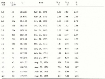
The method has been applied to six groups of open pack ice floes, drifting in the MIZ of the Beaufort Sea. The lower limit, upper limit and mean thickness estimated by the method for the six groups are presented in Table II.
Ice Thickness Estimated from Two-Day Sequences of Landsat-1 Images
Conclusions
An estimate of open pack ice thickness is considered unacceptable if its lower limit is larger than its upper limit (hLL > hUL).
In the absence of simultaneous in situ observations of pack ice thickness, accuracy of the results cannot be tested.
The method may be applied to estimate thickness of open pack ice drifting in any MIZ, by using two-day sequences of sidelapping images.
The required wind field data should be obtained directly from weather data banks rather than from surface weather charts.
Rather than using Landsat-1 MSS images, data from a high resolution active microwave remote sensing system should be employed in the future, as its data will be independent of sun illumination and cloud cover.



