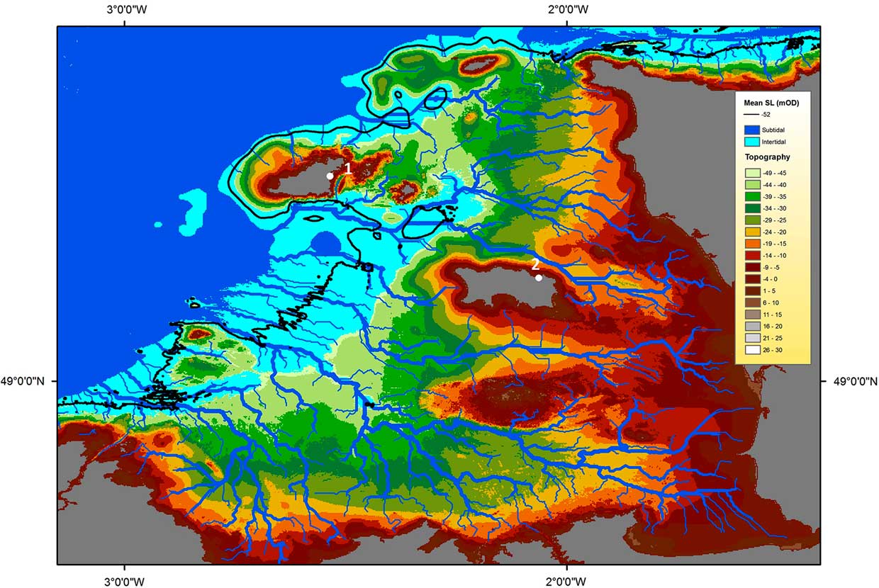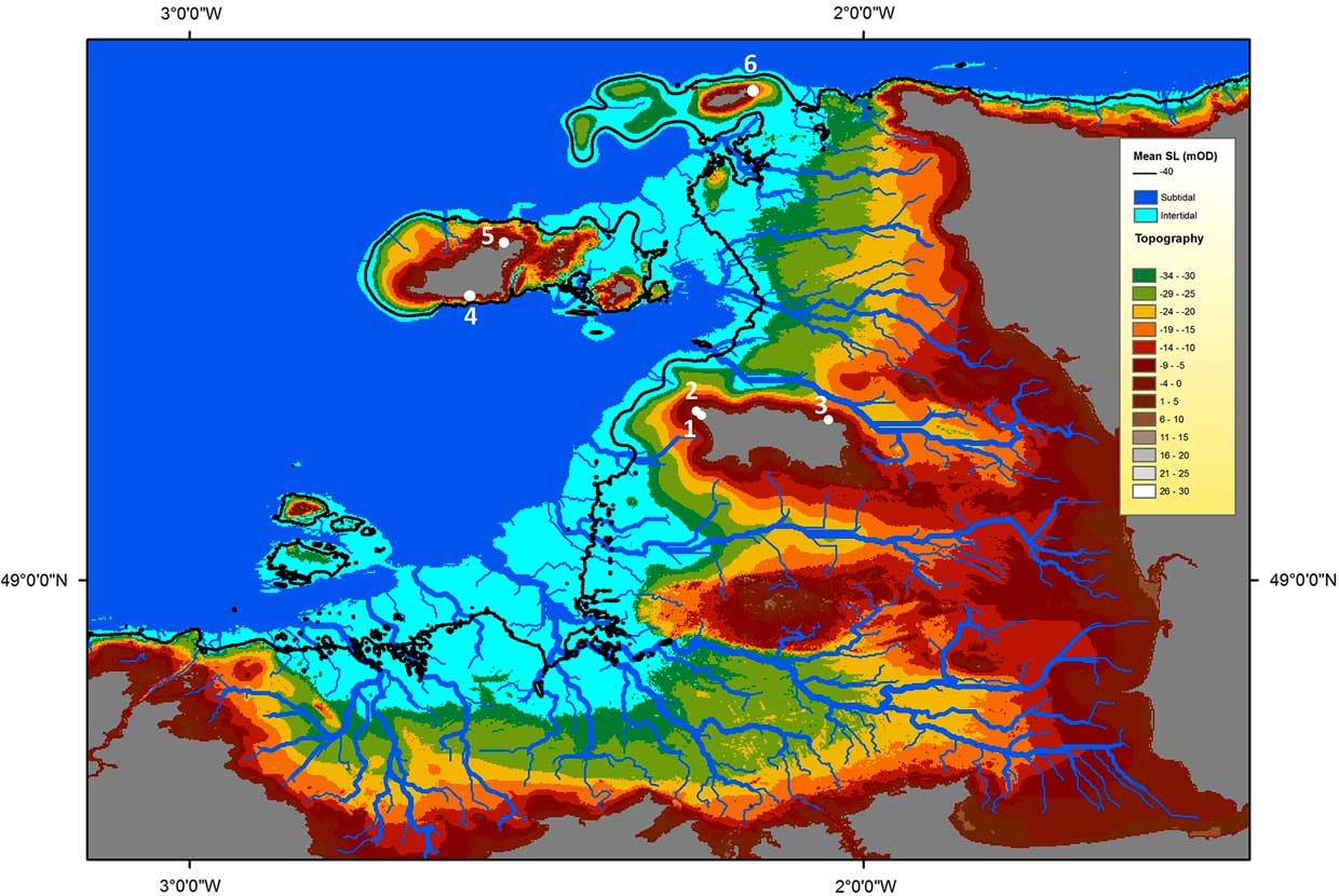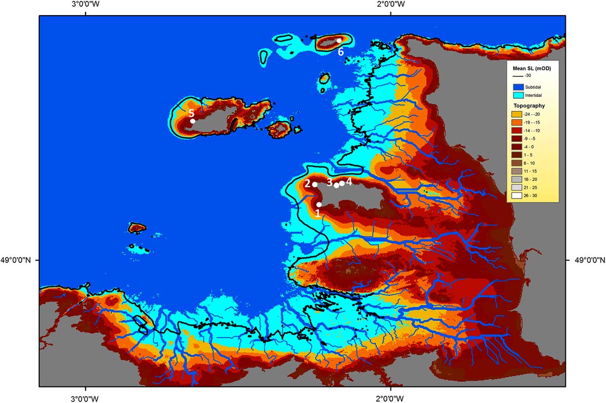


The drowning of Doggerland and the Channel Plain has been the focus of increasing archaeological attention over the past decade and considerable effort has been expended in reconstructing these submerged prehistoric landscapes (Gupta et al. Reference Gupta, Collier, Palmer-Felgate and Potter2007; Gaffney et al. Reference Gaffney, Thomson and Fitch2007; Lericolais et al. Reference Lericolais, Auffret and Cois Bourillet2003; Wessex Archaeology 2007). However, despite increasing knowledge of the topography of these areas, there has been, as Chapman and Lilley (Reference Chapman and Lillie2004) and Leary (Reference Leary2009) note, little discussion of human perceptions of, and responses to, this inundation. This is partly due to current uncertainties over the rate and timing of the inundation. However there is also a perception that such issues are inaccessible until more submerged sites themselves are excavated (eg. Momber et al. Reference Momber, Tomalin, Scaife, Satchell and Gillespie2011).
By contrast, we would argue that ample resources already exist to permit us to address this question, in the form of terrestrial and inter-tidal sites. Nuanced understandings of human responses to the environmental changes associated with sea-level rise have already been achieved through work on inter-tidal areas, most notably by Bell (Reference Bell2007) in the Severn Estuary. However, more could be made of terrestrial sites located in areas affected by local sea-level change, and here we would argue that islands have a special role, representing vital resources for understanding human responses to sea-level rise. In cases where land transforms from continental mainland, to coastal peninsula, to island, people will have needed to reconfigure their pattern of mobility and exploitation as the proportions of different environments altered and significant climatic and vegetational changes occurred.
The Normanno-Breton Gulf during the course of the Upper Palaeolithic and Mesolithic exemplifies just such a situation. In the late Pleistocene, this was a cold, sparsely vegetated and extensive plain (the Normanno-Breton Plain), dominated by the Channel River which flowed to the North of Alderney. This was a massive anastomosing system, with valleys up to 45 km in width, into which flowed a number of high energy, braided rivers from southern England and northern France (Antoine et al. Reference Antoine, Goutard, Gibbard, Hallegouet, Lautridou and Ozouf2003; Gupta et al. Reference Gupta, Collier, Palmer-Felgate and Potter2007). Pettitt (Reference Pettitt2008) has suggested the Channel River formed a major barrier to the colonisation of the British Isles from the south from Middle Palaeolithic times onwards. From the end of the Pleistocene, this vast area was progressively drowned by the rising Holocene sea-level until only the Channel Islands remained above water.
The Channel Islands, the focus of this paper, thus preserve aspects of the archaeology of the now drowned Normanno-Breton Plain. Over the course of the Late Palaeolithic and Mesolithic period, they were gradually transformed from small hills scattered over the upland areas of the Plain, lying to the south of the great Channel River Valley, to peninsulas of northern France and finally islands. The archaeology of the islands therefore represents a record of how people responded to these changing landscapes.
A significant number of Upper Palaeolithic and Mesolithic sites are now known from the Channel Islands. Most of these are surface scatters, but this paper also reports on two recent excavations, on Lihou (GU582), Guernsey, and at Canal du Squez, in Jersey. While radiocarbon dates are currently limited to Lihou, recent advances in understandings of the typochronology of the northern French Mesolithic can provide a broad chronology for these sites. This is of sufficient resolution to understand whether Mesolithic occupation occurred before or after each of the Channel Islands became an island and thus examine human responses to insularisation.
The Channel Islands have a long history, both geographically and culturally, as part of northern France. Alderney, the closest of the Channel Islands to France, is only 13 km from the current coast of Normandy. Lithic traditions on the islands, thus as might be expected, are analogous to those of northern France. Northern France is thus the logical place to seek a chronological scheme in which to place the assemblages of the Channel Islands Mesolithic.
The Mesolithic Of Northern France
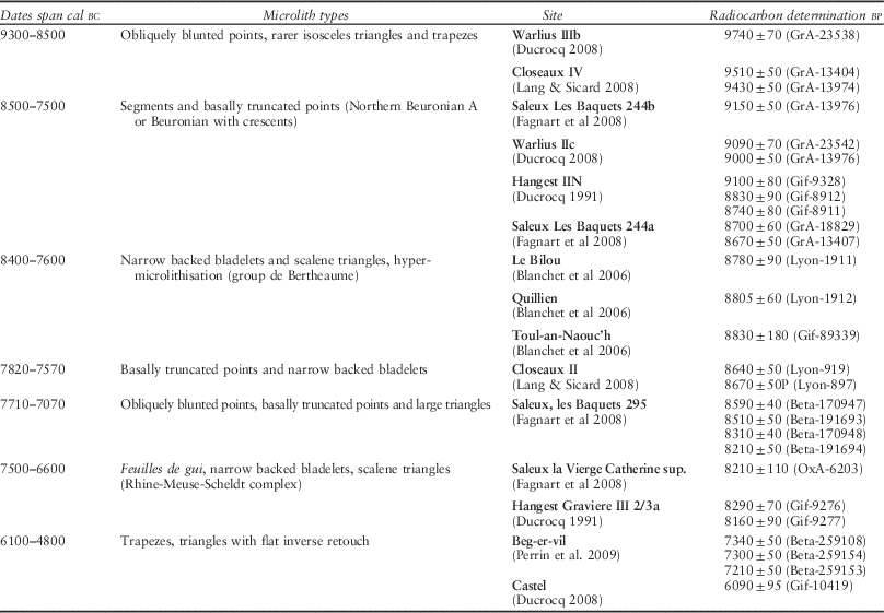
The Mesolithic of northern France has been the focus of increasing attention over the past few decades, often in the context of developer-funded archaeology. Particularly important for chronological considerations has been Ducrocq’s work (Reference Ducrocq2001) on the Somme and sites in Picardy more broadly (Ducrocq et al. Reference Ducrocq, Bridault and Coutard2008). The focus on small, single episode occupation sites and the favourable contexts for preservation in these northern French river valleys have permitted a well-dated typological sequence to be constructed for the Mesolithic east of the Seine. New work has also been undertaken west of the Seine, in areas closer to the Channel Islands, in particular by Souffi (Ghesquière et al. Reference Ghesquière, Lefèvre, Marcigny and Souffi2000; Souffi Reference Souffi2004; Reference Souffi2008) and Ghesquière (Ghesquière et al. Reference Ghesquière, Lefèvre, Marcigny and Souffi2000; Ghesquière Reference Ghesquière2010, 20; 2011) in Normandy and by Marchand (Reference Marchand2005; Reference Marchand2007; Reference Marchand2013) in Brittany. The contexts of many of these sites are less favourable for organic preservation and many appear to be palimpsests on sandy sediments lacking internal stratigraphy, making the construction of chronologies rather more difficult. However enough is known to provide a chronology within which to fit the Mesolithic sites of the Channel Islands. The Mesolithic in northern France, as in most of Europe as a whole, is divided into three phases: An Early Mesolithic dominated by simple obliquely blunted points and large triangles; a Middle Mesolithic with basally modified points and increasing numbers of backed bladelets and scalene triangles; and a Late/Final Mesolithic characterised by the appearance of trapezes.
Early Mesolithic
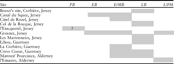
Assemblages dating to the Pre-Boreal in northern France are characterised by obliquely blunted points and smaller quantities of trapezes and isosceles triangles (Table 1). The earliest dated Mesolithic assemblage in northern France is Warlius secteur IIIb (Ducrocq et al. Reference Ducrocq, Bridault and Coutard2008; Ducrocq Reference Ducrocq2013). This material is similar to Star Carr type assemblages found across England and Wales, that also seem to mark the earliest Mesolithic in Britain (Reynier Reference Reynier2005). On the banks of the Seine, Closeaux, Reuil-Malmaison, secteur IV, is slightly later, but also belongs to this period (Lang & Sicard Reference Lang and Sicard2008). Similar assemblages are also known west of the Seine at Acquigny WXY/61–62 in Haute-Normandie (Souffi Reference Souffi2008) and at les Vingt-Deux Boisselées in Brittany (Marchand Reference Marchand2008), though these are currently undated.
Radiocarbon Dated Mesolithic Sites from Northern France1

Middle Mesolithic
From around 8500 cal BC, broadly equivalent to the start of the Boreal, new assemblages dominated by segments and basally truncated points appear, sometimes termed the northern Beuronian A (Ducrocq et al. Reference Ducrocq, Bridault and Coutard2008) or Beuronian with crescents (Ducrocq Reference Ducrocq2013). The latest dates for Beuronian A sites seem to fall into the 8700 bp radiocarbon plateau. These assemblages are found at several sites north of the Seine and are dated at Saleux les Baquets 294a and 294b, Warlius 2c, and Hangest IIN (Table 1; Fagnart et al. Reference Fagnart, Coudret and Souffi2008; Ducrocq et al. Reference Ducrocq, Bridault and Coutard2008). Basally truncated pieces can have either a transverse truncation (Saleux Les Baquets 244b), an oblique or concave (Horsham-type) truncation (Saleux La Vierge Catherine) or both. Some assemblages contain just segments and basally truncated pieces; however in others (Warlius IIc and Saleux les Baquets 294a), obliquely blunted points are also present. West of the Seine these assemblages are also present in Haute-Normandie at the undated sites of Acquigny B and Acquigny E/69–70 (Souffi Reference Souffi2008) and possibly at l’Organais in Brittany (Marchand Reference Marchand2008). Segments appear to be a particularly useful chronological indicator as they are only characteristic of this phase, whereas other types, in particular obliquely blunted points, persist throughout the first two millennia of the Mesolithic. Recent work suggests that the northern Beuronian A is associated with the appearance of denser forests containing hazel and a focus on the predation of wild boar (Séara et al. Reference Séara, Bridault, Ducrocq and Souffi2010).
The record for the middle and late part of the Boreal is less clear. East of the Seine, an assemblage from Closeaux Secteur II (Lang & Sicard Reference Lang and Sicard2008) is characterised by basally truncated pieces and narrow backed bladelets and dated to 7820–7570 cal BC. Collections with a component of backed bladelets and small scalene triangles probably appear from around 7700 cal BC. From around 7400 cal BC, until at least 6600 cal BC, assemblages containing feuilles de gui (mistletoe points) and other pieces with inverse invasive retouch appear, sometimes termed the Rhine-Meuse-Scheldt complex or RMS A (Gob Reference Gob1985; Ducrocq Reference Ducrocq2014). These are accompanied by backed bladelets, sometimes truncated, and small scalene triangles. The few faunal assemblages of this period suggest a greater range of animals predated than during the Beuronian, with remains of roe deer, red deer, pig, and aurochs recovered. This period is one of the least well known in northern France (Ducrocq et al. Reference Ducrocq, Coutard, Routier and Bridault2013).
While sites to the west of the Seine are less well dated and tend to represent palimpsests, existing evidence suggests that within this broad sequence varied regional chronologies and technical traditions exist. In Brittany the Bertheaume group, dated at around 8400–7600 cal BC is characterised by narrow backed bladelets with one or two sides retouched and small scalene triangles (Marchand Reference Marchand2005, 48; Blanchet et al. Reference Blanchet, Kayser, Marchand and Yven2006). Obliquely blunted points and basally modified points are present, but rare. Hyper-microlithisation is a notable feature of this industry. In Normandy the sequence appears similar to the Paris Basin: industries with basally modified pieces and backed bladelets are common in the first half of the Boreal, accompanied by scalene triangles and simple obliquely truncated points. Crescents are rare. These are exemplified by the dated sites of Flamanville-Centrale EDF (8990±190 Bp; Gif-89334) and Auderville, Roc de Gîte (8460±170 Bp; Gif-89337) (Ghesquière et al. Reference Ghesquière, Lefèvre, Marcigny and Souffi2000). The latest Middle Mesolithic assemblages (though undated) in Basse-Normandy are considered to be Flamanville Le Coquet and Rozel Station 56. These are characterised by the presence of mainly symmetric basally modified points, simple obliquely truncated points, the increased presence of scalene triangles (≤40%) and diminished number of backed blades (not greater than 9%) (Ghesquière et al. Reference Ghesquière, Lefèvre, Marcigny and Souffi2000). Feuilles de gui do not appear to the west of the Seine and the river seems to have formed an important cultural barrier towards the end of the Boreal. Broadly to the west of the Seine, early Boreal assemblages appear to be characterised by obliquely blunted points and basally modified pieces, with increasing quantities of narrow backed bladelets. In the later part of the Boreal, scalene triangles increase in number at the expense of backed bladelets (Ghesquière Reference Ghesquière2010).
Final Mesolithic
The Final Mesolithic (or Second Mesolithic) marks a shift in both microlith types and technology. Assemblages with trapezes and regular blades made through pressure flaking or indirect percussion appear across Europe (apart from Britain and Ireland), reaching northern France around 6200 BC (Costa & Marchand Reference Costa and Marchand2006; Perrin et al. Reference Perrin, Marchand, Allard, Binder, Collina, Garcia-Puchol and Valdeyron2009). Sites in northern France are not well dated, but have yielded symmetrical and asymmetric trapezes and triangles and crescents with flat inverse retouch. In Picardy, three phases are present: the first consisting of small trapezes, the second of large trapezes with offset bases, and the final phase (Terminal Mesolithic) consisting of asymmetric trapezes and a range of triangular forms with flat inverse retouch (Ducorcq 2014). In Normandy two phases have been proposed, the first characterised by the presence of asymmetric trapezes and scalene triangles, the second by triangles with flat inverse retouch (Artur et al. Reference Artur, Billard, Hervieu, Marie and Dubrulle2008). In Brittany the Tévevian (Rozoy Reference Rozoy1978) is characterised by the presence of symmetrical and asymmetric trapezes and triangles. New work suggests that sites (such as Beg-er-Vil) characterised by symmetrical trapezes are succeeded by sites (Hoëdic, Beg-an-Dorchenn) where levels of asymmetric trapezes and triangles increase (Marchand and Musch Reference Marchand and Musch2013). The arrival of the Neolithic in Northern France dates to between 5300 and 4800 BC and these groups used a very similar set of armatures to the last Mesolithic people (Perrin et al. Reference Perrin, Marchand, Allard, Binder, Collina, Garcia-Puchol and Valdeyron2009; Marchand Reference Marchand2007).
From northern France to the Channel Islands
Mesolithic material from the Channel Islands bears greatest similarity to material from Normandy. Though radiocarbon dates have been obtained for two Normandy Mesolithic sites, both appear to be palimpsests, making the construction of a precise typo-chronology for the Channel Islands problematic. However, though significant regional variation is present in northern France, sufficient broader patterning in typological change exists to permit the use of material from well dated contexts to gain a broad understanding of the chronology of the occupation of the Channel Islands. Without further radiocarbon dating, this chronology is invariably imprecise; however the present resolution is sufficient to understand broadly the relationship between colonisation, occupation and insularisation.
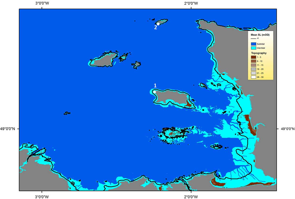
The Channel Islands
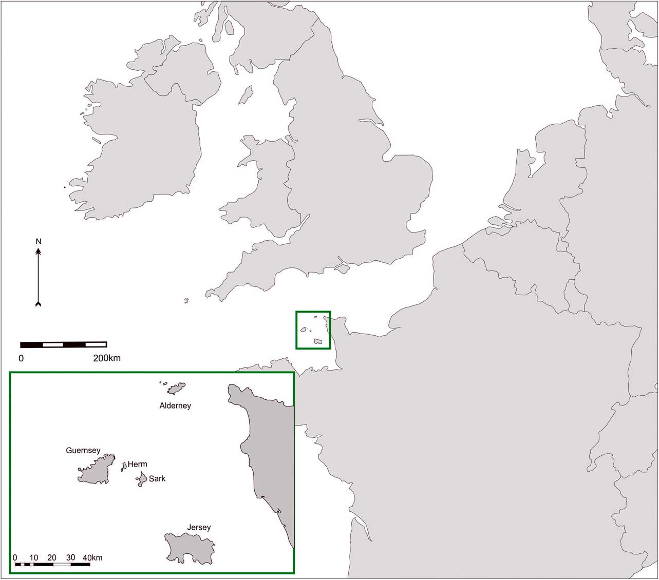
The Channel Islands are an archipelago in the Normanno-Breton gulf, consisting of the two largest islands Jersey and Guernsey; the smaller islands of Alderney, Sark, and Herm; and the islets Lihou, Jethou, Brecqhou, and Burhou (Fig. 1). None of these islands is particularly large, Jersey, the largest measures only 19 km across, while the islets can be measured in hundreds of metres. There are also a number of reefs, mainly around Jersey, that consist of only a few rocky areas at high tide, but are extensive at low tide. The Minquiers at low tide are half the size of Guernsey; the Ecrehous larger than Alderney (Sebire & Renouf Reference Sebire and Renouf2010). The Channel Islands have one of the largest inter-tidal ranges in the world, at 12 m around the coast of Jersey. This may have been lower in the past (Sebire & Renouf Reference Sebire and Renouf2010), however it creates a large boundary of uncertainty in assessing the timing of sea level rise and the process of insularisation.
The Channel Islands

The combination of a large tidal range and a shallow surrounding sea-bed mean that sea-level rise is played out in microcosm daily. Low tides reveal intermittently, some of the landscapes drowned by the inundation. Tree stumps from a submerged forest have been encountered in peat deposits in St Ouen’s Bay, Jersey, sometimes accompanied by Neolithic flint, pottery, and cattle bones (Anon Reference Anon.1797; Sinel Reference Sinel1909). Peat, tree stumps, and artefacts from periodic exposures are also known from Vazon Bay in Guernsey (Campbell Reference Campbell2000), while artefacts have also been found in association with intertidal peats at Longis Bay in Alderney.
Mesolithic material was first noted in the Channel Islands in Guernsey by Kendrick (Reference Kendrick1928), who mentions flint chipping areas at La Corbinerie, at Creve Coeur, and on the tidal island of Lihou and illustrates microliths from La Corbinerie and l’Islet. Hawkes (Reference Hawkes1937) in her equivalent survey of Jersey, considered Mesolithic influence to be absent or negligible, yet also illustrated microliths from l’Etacquerel and Grosnez. None of these, with the exception of l’Islet (which is a megalithic tomb), came from excavated contexts, instead they were collected from ploughed fields or areas of coastal erosion.
Further Mesolithic sites were brought to light by Mark Patton (Reference Patton1993) through a survey of museum collections from Jersey, Guernsey, and Alderney during the course of doctoral research. Patton suggested a basic chronology of these sites: He identified Le Canal du Squez, Le Col de la Rocque, and Câtel de Rozel in Jersey, La Corbière and Creve Coeur in Guernsey and Porcieux/Mannez in Alderney as Middle Mesolithic in date; Grosnez Hurel in Jersey and l’Emauve in Alderney were considered to potentially be Late Mesolithic. Mesolithic material was also noted by Keen in his surveys of the islands in the 1970s and 1980s.
Since Patton’s synthesis, much new Mesolithic material has come to light through the work of certain dedicated amateur archaeologists, in particular Brian Phillipps in Jersey. New excavations have also been undertaken recently, at Lihou (GU582), Guernsey, by Tim Schadla-Hall between 2001 and 2003, and at Canal du Squez, Jersey, initially by Mark Patton in 1993 and then by the Quaternary Archaeology and Environment of Jersey project (Bates, Conneller, Pope, Scott, Shaw; henceforth QAEJ) in 2010.
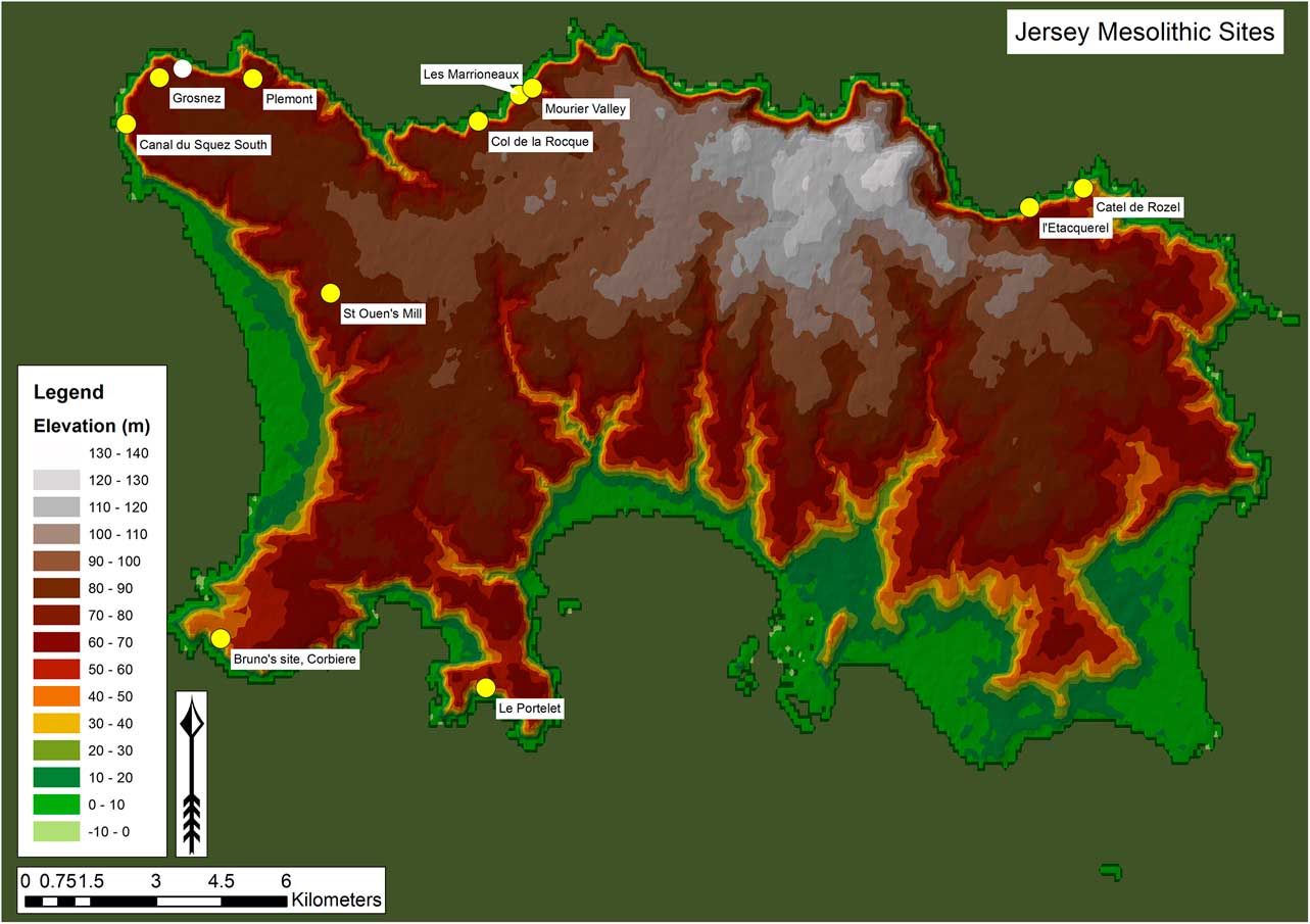
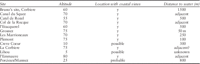
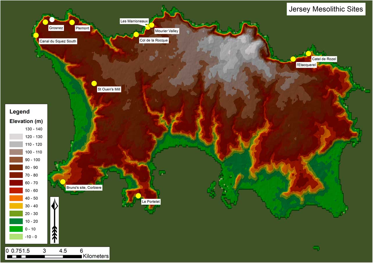
This article presents the results of the excavations at Lihou and fieldwork by QAEJ at Canal du Squez. An assessment of material held by Guernsey Museum (2007), Jersey Museum (2010 and 2012) and Alderney Museum (2012) was undertaken by Chantal Conneller in order to place the excavated sites into the broader context of the occupation of the Channel Islands. In addition to the sites discussed by Patton, Mesolithic material can be confirmed at Grosnez Racecourse, Les Marionneux, l’Etacquerel, Bruno’s site (Corbière), ‘100 Foot Gulch’ (Blanches Banques), Plemont, St Ouen’s Mill, Portlet Common, Tete de Quennevais, L’Ouziere, and the Mourier Valley, all in Jersey (Fig. 2) and at Port Soif, Fort Pembroke, Hommet Bennest, and 18–20 Le Pollet, in Guernsey (Fig. 14, below).
Location of Mesolithic sites in Jersey
Jersey
Jersey is the largest of the Channel Islands with an area of 118 km2 (Jones et al. Reference Jones, Keen, Birnie and Watson1990). The majority of the island consists of a north–south sloping plateau topped by loessic deposits, drained by valleys running mainly north–south. The north of the island is dominated by high (up to 130 m) cliffs of plutonic and volcanic rocks with a conglomerate forming the lower plateau in the north-east. In the south and south-east lies a c. 2km wide coastal plain, overlooked by the ubiquitous fossil cliff line, trimmed in Middle and Upper Pleistocene times, but with its origins at least in the early Tertiary (Lautridou Reference Lautridou1989; Renouf 1993).
Jersey has the largest number of Mesolithic sites of all the Channel Islands (Fig. 2). This is partly a function of its size, but is also a result of the extensive fieldwork of Mr Brian Phillipps, who has located a series of Mesolithic sites in the west and north of the island. Phillipps’ meticulous collection strategies – focused on total recovery of even the smallest chips – has resulted in the recovery of numerous microliths, facilitating attribution of his sites to the Mesolithic period.
Jersey has also seen the majority of palaeoenvironmental work in the Channel Islands (Jones et al. Reference Jones, Keen, Birnie and Holyoak1987; Reference Jones, Keen, Birnie and Watson1990). While most evidence covers the mid-Holocene onwards, some data does exist for latest Pleistocene and earlier Holocene landscapes. Jones and colleagues (2004) describe a tundra landscape of Younger Dryas age from Queen’s Valley in the east of the island. A core from near Quetivel Mill in St Peter’s Valley in the south-east of the island reveals that at around 9200 cal BC peat began to form in a wetland environment of grasses, sedges and ferns. On the valley side and plateau top was open woodland of birch with smaller quantities of pine and hazel. This horizon is associated with high charcoal levels, though whether this is anthropogenic or natural is uncertain.
A core from Le Port, St Ouen’s Bay reveals a picture of the early Holocene environment on the coastal plain in the west of the island, and is located only 5 km from the Mesolithic site of Canal du Squez (Jones et al. Reference Jones, Keen, Birnie and Holyoak1987). The pollen assemblage from the lowest level indicates an open grassland landscape with a variety of herbs and shrubs such as willow. Birch, pine, and hazel are also represented, but in general trees were sparse. This vegetation may be broadly representative of that of the now drowned Normanno-Breton Plain to the west and north of Jersey. Jones et al. (Reference Jones, Keen, Birnie and Watson1990) suggest that large areas of the plain were covered by deposits of coversand. This and rising sea-level may have maintained an open landscape across much of the coastal plain. A radiocarbon date from the lower part of the overlying clay peat provides a minimum date of 8720±70 Bp (SSR-2839; (8160–7580 cal BC) for this landscape, indicating it is broadly contemporary with early Boreal sites on the island such as Canal du Squez.
The pollen spectra from the overlying clayey peat is dominated by hazel, oak, birch, and pine, indicating developed tree cover in drier areas and willow, sedges and meadowsweet in wetlands. The lower peat is separated from an upper peat by a sand layer possibly caused by costal instability. A water-table rise caused by rising sea-level led to the demise of these oak–hazel woodlands that dominated drier areas of the coastal plain during the Boreal. The upper peat, with a radiocarbon date of 7090±60 Bp (SSR-2836; 6060–5840 cal BC), formed in a freshwater swamp and fen, dominated by alder, which probably developed landward of a sand barrier, as sea-level slowed. A core from l’Ouzière, around 1 km north of le Port, records undated sediments probably belonging to the later part of the Mesolithic from around 5900 cal BC. This core paints a similar picture to Le Port of a well wooded landscape of hazel and oak, with rising quantities of alder late in the sequence. Willow, birch, and alder indicate the present of freshwater swamp and fen in the proximity of the site. A tranchet axe from l’Ouzière may belong in this landscape; however in Northern France these are seen as more indicative of Early Neolithic activities (Artur et al. Reference Artur, Billard, Hervieu, Marie and Dubrulle2008).
Le Canal du Squez
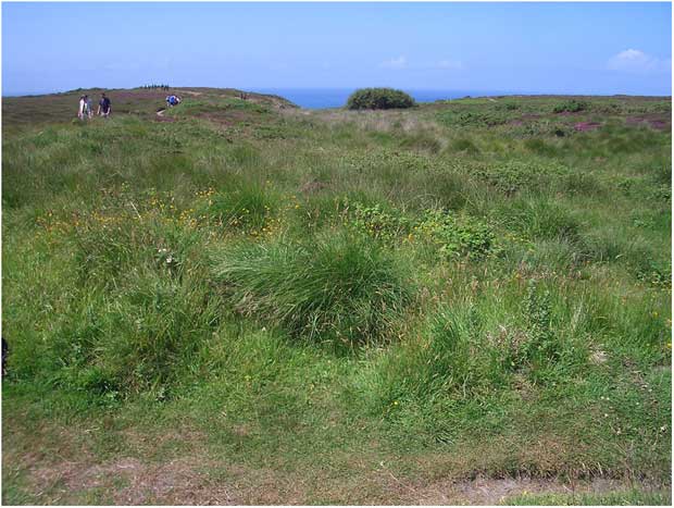
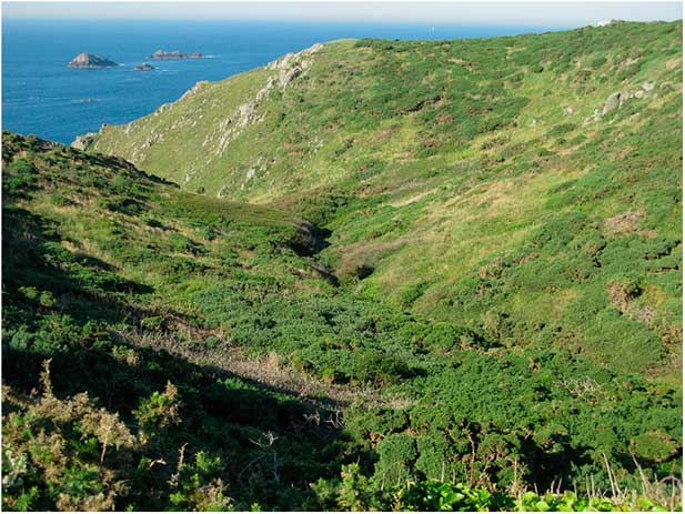
Le Canal du Squez is located within a shallow, hanging valley on the elevated north-west corner of Jersey, in an area of coastal heathland known as Les Landes (Fig. 2). The valley was the location of a pollen core (le Beau Vallee) taken during palaeoenvironemnetal survey of the island (Jones et al. Reference Jones, Keen, Birnie and Watson1990), but was undated, and is thought to contain only sediments dating from the mid-Holocene onwards. The Mesolithic site was discovered by Brian Phillipps of the Société Jersiaise in the early 1990s, at a location where material had been eroded from the sandy subsoil due to the incision of paths which meander through the locale (Fig. 3). Phillipps’ collection is comprehensive and particular attention has been paid to the recovery of small material, both microliths and debitage. The material is divided into pieces collected from the south side or the north side of the valley. In all, Phillips’ collection from the site numbers 8760 pieces. Additional collections derive from Canal du Squez, such as the Percival collection of nearly 300 pieces.
Canal du Squez
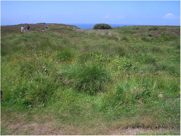
The path which flanked the south side of the valley was subjected to controlled collection by Mark Patton and the Société Jersiaise which pinpointed the origin of the lithic material along either side of a path and isolated potential concentrations (Patton Reference Patton1993; Reference Patton1994). This work was followed up by direct excavation within the base of the valley itself, which failed to reveal any in situ flintwork.
Erosion has continued substantially during the course of the past two decades and Mesolithic flintwork is abundantly visible on the existing paths. Erosion had proceeded in places through to the underlying granite bedrock leading to the destruction of the site in areas. Elsewhere this ongoing process had resulted in the denudation of physical matrix within which the material is held. As a result fieldwork was undertaken by the QAEJ project in 2010 in order to contextualise the material and assess the threat posed to the scatter by ongoing erosion.
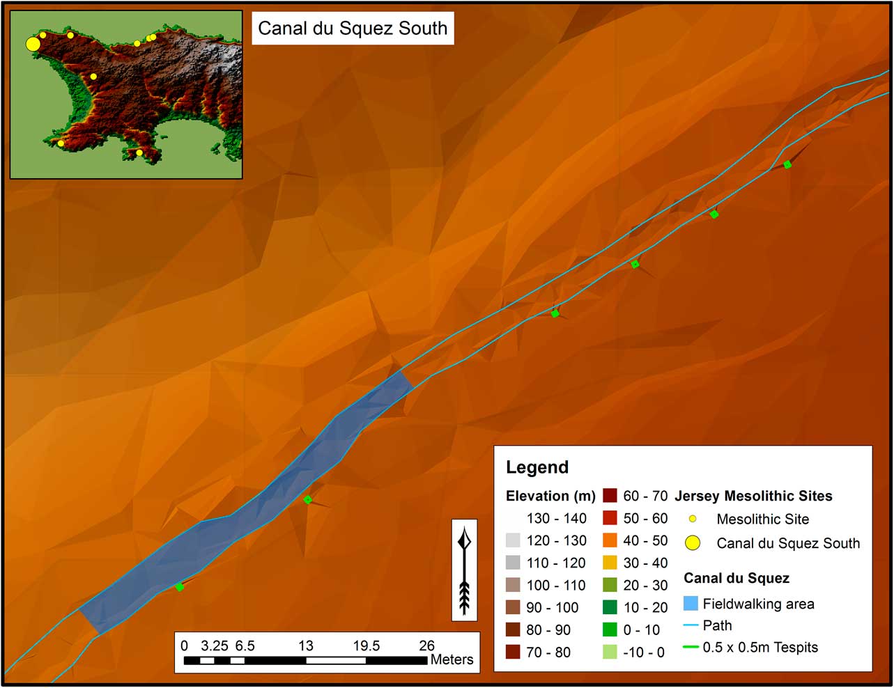
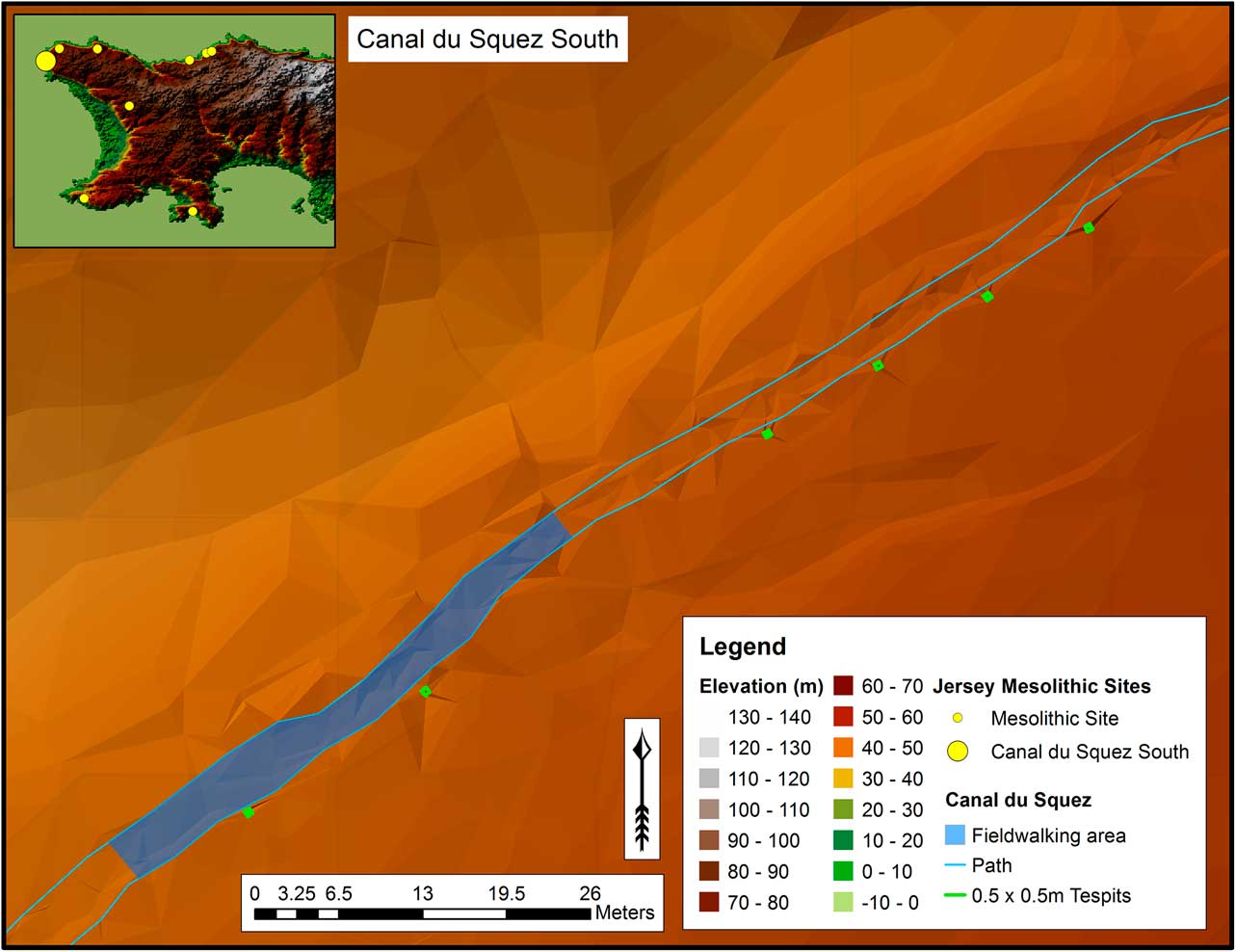
This project built on Patton’s work by directly targeting the areas of concentrated flintwork identified through his collection survey. In contrast to the previous research which targeted the down-slope valley, testpits were located along the southern, uphill, flank of the path (Fig. 4). Six test pits were excavated along an 80m transect down to the top of the solid geology. As the largest area of coastal heathland on the island, Les Landes is a Jersey Site of Scientific Interest (SSI). In order to keep impact to a minimum, each testpit was only 0.5×0.5 m in size. In addition, a gridded surface collection of the path was undertaken to provide a record of the current threat to the archaeology through erosion.
Location of QAEJ test-pits and gridded fieldwalking
Geoarchaeological Investigations
A series of boreholes was drilled across the site to integrate with the test-pit data recorded in the archaeological interventions. All indications from the sediment confirm the notion that the site lies within a small basin-like feature draining to the west. The sediments are dominated by sand-sized sediments derived from erosion of the local bedrock that was washed into the basin via sheetwash and potentially minor rills and gullies draining into the main axial drainage across the site. It is possible that localised patches of blown sand are also present within the sequence, being derived from local sources on the basin margins as well as more distant locations to the west at lower elevations.
Finds
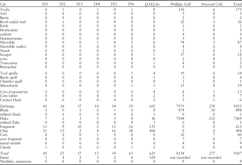
Two hundred and eight lithic artefacts were recovered from excavated contexts at Canal du Squez, with each 0.5 m test-pit yielding between 15 and 63 pieces (Table 2). In addition, 623 pieces of flint were recovered during gridded fieldwalking along 100 m of the Le Squez footpath (Fig. 4). The presence of in situ lithic material in testpits and gridded fieldwalked collection stretching for c. 120 m, along with Brian Phillipps’ observation that material can be collected for c. 200 m along the path of the south side of Le Squez confirms the large size of the Mesolithic occupation area.
Canal Du Squez Assemblage Composition

Tools
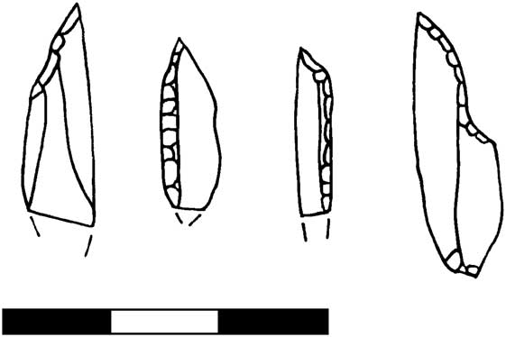
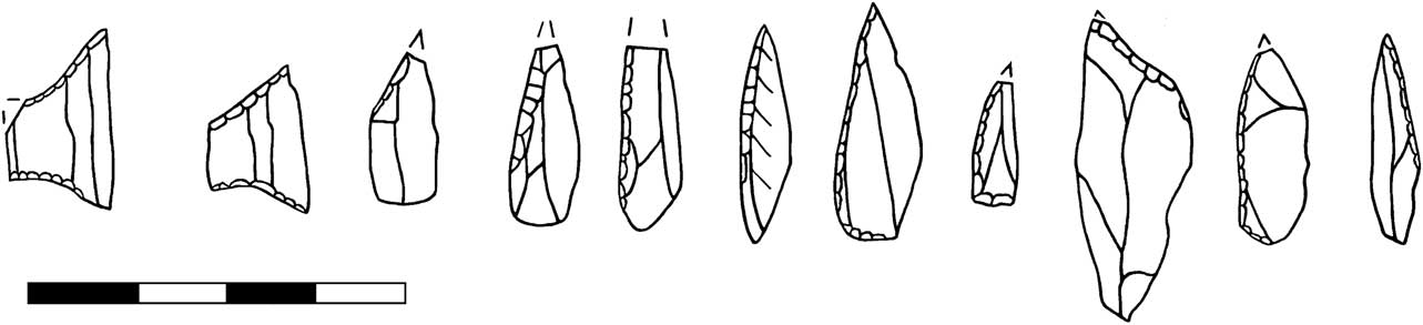
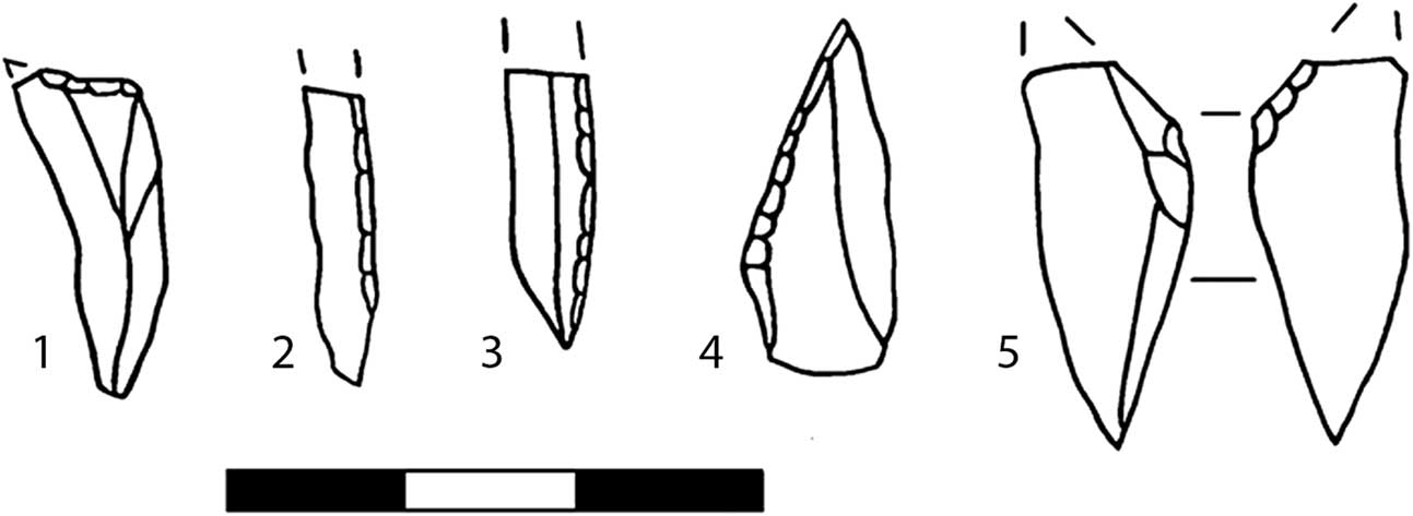
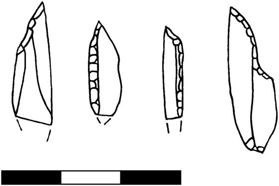
The excavated material is dominated by debitage, with tools relatively rare (Table 2). Four microliths were recovered: a broken obliquely blunted point with possible basal modification from test-pit 4 and a narrow backed bladelet and two scalene triangles from test-pit 6 (Fig. 5). One of the triangles (Fig. 5d) is unfinished and this and a proximal microburin also excavated from this test-pit indicates microlith production, and retooling in this area. This test-pit also had a high proportion of burnt flint, perhaps indicative of proximity to a hearth, which might be expected for an area of microlith manufacture.
Microliths from excavated contexts at Canal du Squez
The only other tool recovered from excavation was a bevel ended tool from test-pit 3, along with three additional fragments of imported stone. These elongated stone artefacts are a common feature of the Middle Mesolithic of northern France and the Channel Islands (Ghesquière et al. Reference Ghesquière, Lefèvre, Marcigny and Souffi2000). Some have ends that have been rubbed smooth through abrasion, others appear to have been used for percussion, probably as hammer stones.
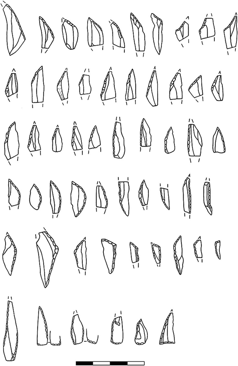
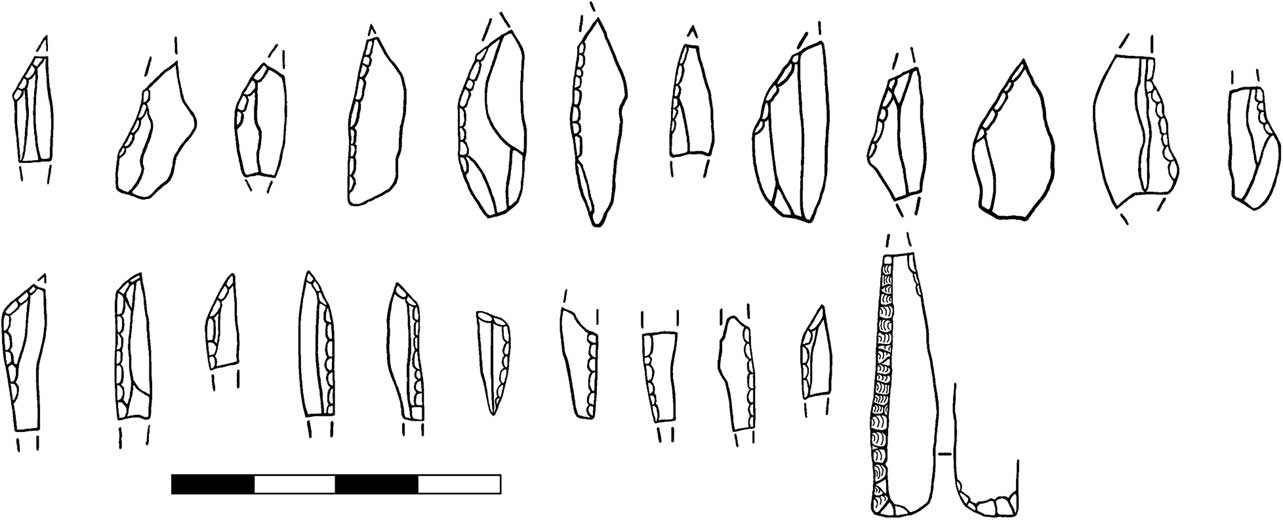
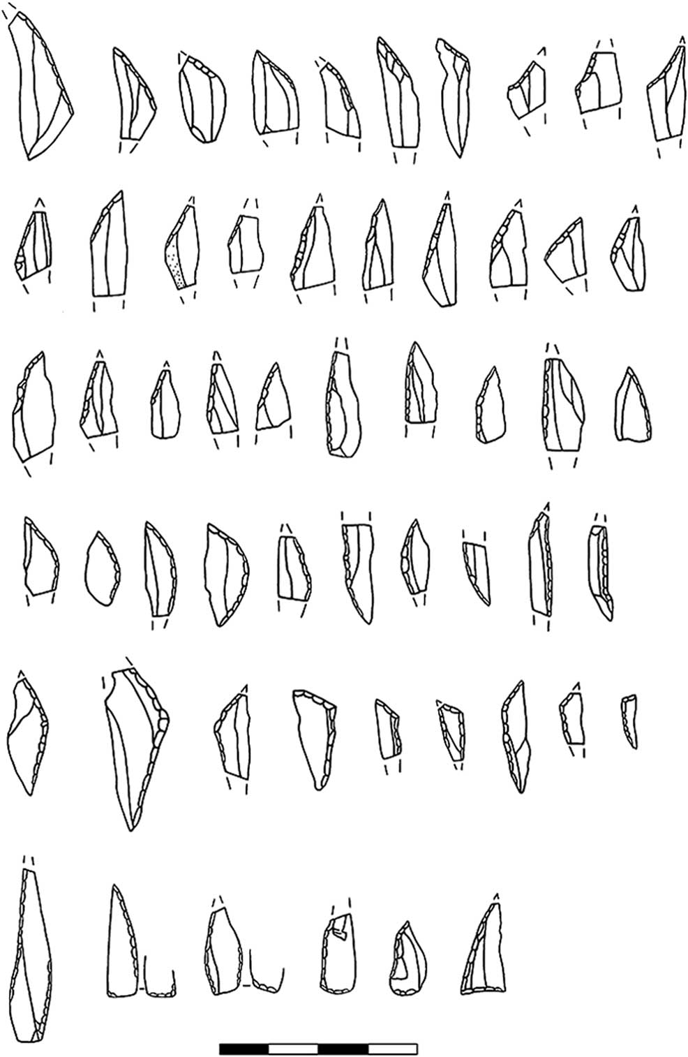
More tools were recovered in the gridded fieldwalking. Microliths were again the most common type with six examples recovered; most of these were fragmentary, though a complete obliquely blunted point was recovered. A much larger sample of microliths derive from Brian Phillipps’ collections: 25 obliquely blunted points, five partially backed bladelets, six segments, six basally modified pieces, two isosceles triangles, six scalene triangles, two narrow backed bladelets, and one truncated backed bladelet (Fig. 6). Assemblages dominated by obliquely blunted points, segments and basally modified pieces are indicative of early Boreal assemblages spanning 8500–7600 cal BC. Segments in particular appear to have a relatively spatially restricted distribution. Isosceles triangles can be indicative of an even earlier Pre-Boreal date, but also have been suggested to occur with obliquely blunted points and large scalene triangles (two of which are also present at Canal du Squez) in mid-Boreal assemblages, as at Saleux Les Baquets 295, which has three dates centring on 7400 cal BC. Scalene triangles are found in France from around 7900 cal BC (Rozoy Reference Rozoy1978), as are narrow backed bladelets. Truncated backed bladelets appear in Normandy and the Channel Islands to be associated with late Boreal assemblages. Overall while the majority of the microliths indicate an early Boreal date, there are likely to have been some later Boreal visits to the area.
Microliths from Canal du Squez (Phillipps Collection)
Beyond microliths, three microburins were recovered from the QAEJ gridded fieldwalking and a further 15 from Brian Phillipps’ collection, indicating widespread microlith production in the vicinity. Other tools were relatively rare in the gridded fieldwalking, a scraper fragment, and oblique truncation.
A broader variety of tools is present in the Phillipps collection. This includes some later prehistoric material, as indicated by a handful of Neolithic trapezes and transverse arrowheads. Though Late/Final Mesolithic and Neolithic armatures are similar, these pieces are larger and more irregular than Mesolithic examples from the Channel Islands and northern France. Data from the gridded fieldwalked collection suggest that later prehistoric material increases nearer the coastal cliff. Other tools in the Phillipps collection may also be of later prehistoric date. Core/denticulates, core scrapers, and chunky denticulated pieces are a feature of later prehistoric flintworking, but are also present amongst some Mesolithic assemblages in the region, such as Auderville in Normandy and Lihou, Guernsey (see below). These sites are mid-/late Boreal in date. Seventeen scrapers were recovered, some of which may be Mesolithic; others would sit more comfortably in later prehistoric assemblages. Also present in the collection are two burins, which are represented in low numbers in the Middle Mesolithic assemblages of the Cotentin, but could also be of Neolithic date.
More likely to be of Mesolithic date are a series of truncations, often oblique, on neat bladelets. These are a feature of the Normandy Middle Mesolithic and are also common on other Mesolithic sites in Jersey. Some of these appear to have been used as for piercing, and are very similar to some of the awls recovered, that consist of an oblique truncation, with additional retouch around the point. Also of likely Mesolithic date are the 32 bevel-ended tools amongst the Phillipps collection. These are a key feature of the Middle Mesolithic of Normandy. Numerous imported flat stones (plaquettes) were also recovered, as were rounded pebbles that were sometimes used as hammerstones.
Technology
The technological schema is focused on blade and fine flake production. Blades represent 9.7% of the total collection. There is notably more effort expanded in the production of regular pieces than in later Boreal sites such as Lihou, Guernsey, where blades represent only 5.6% of the assemblage. Skill, and effort to maintain the life of a core is in evidence at Canal du Squez: platforms were prepared and rejuventated; cresting occurred. Cores are either single platform examples, mainly with removals part of the way round and a cortical back or two platform examples, with either opposed platforms or platforms at 45° or 90°. A few multi-platform cores are also present. Some cores have been established on large flakes. Rather than simply using the ventral surface of the flake as a platform, as is common amongst Middle Mesolithic sites of the Cotentin, these are often multi-platform examples where most of the original ventral surface of the fake has been removed by plein debitage. Both flakes and blades show neatly abraded platforms, plain platforms, and diffuse bulbs of percussion. It seems likely that knapping took place using a soft hammer or perhaps a soft stone hammer.
The raw material used was all flint. This ranges in colour from grey speckled, brown speckled, honey coloured, dark brown, and red. The material ranges in quality from translucent fine grained material to coarser flint with a more cherty appearance. Cortical pieces display the heavy pitting typical of beach material and indicate that raw material was exclusively obtained from local beaches. As far as can be ascertained, beach pebbles were the only source employed in the Channel Islands during the Mesolithic period. The original source of this flint was probably a now inundated chalk source north of Alderney (Callow & Cornford Reference Callow and Cornford1986), since flint beach pebbles increase in quantity and size on northern beaches, with Alderney having the best supplies of all the Channel Islands (Keen Reference Keennd). Beach pebbles can be of very poor quality, but some effort appears to have been made to collect larger and better quality nodules at Canal du Squez in comparison with other sites such as Lihou. Some tested nodules or minimally reduced cores are have been recovered, perhaps suggesting that pebbles were tested at source for quality before being imported to site. In the collection 20% of debitage are primary or secondary flakes, a proportion that is compatible with this strategy.
Grosnez
The Grosnez area is just to the north-east of Canal du Squez, on the northern part of Les Landes (Fig. 2). Gosnez Hurel is Jersey’s only other excavated site, which was investigated in 1925 by Godfray, Rybot, Mourant, Richardson, and Thompstone. Lithic material is recorded as lying within a mound of sandy loam, 3 ft (0.91 m) deep and 36 ft (10.93 m) in diameter, around 200 yds (c. 183 m) south-east of Grosnez Castle. Mourant recorded that there were well over 100 flints found. In the collection from Jersey Museum 64 flint artefacts remain. Amongst these are an asymmetric trapeze, a denticulated core/scraper, and an invasively flaked scraper. Grosnez Hurel was noted by Patton (Reference Patton1993) as the only Late/Final Mesolithic site on the island. This is indicated by the presence of the asymmetric trapeze (Fig. 7). However the remainder of the material from the excavation is probably of mixed date, as it seems to display different technological characteristics and conditions, with both patinated and unpatinated material present. The extant collection does however contain a large number of bladelets (25 examples), as well as fine flakes which display platform abrasion and narrow platforms which are of Mesolithic date. Also present amongst the collection are a number of plaquettes and four bevel-ended tools made of imported mica-schist (Patton Reference Patton1993), two of which have evident signs of use in percussive activities. Two hammerstones were also found, one of flint, one of stone.
Microliths from Grosnez/Les Landes
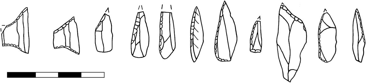
Grosnez Hurel represents just one area of Mesolithic activity amongst many at Grosnez. A large collection of material comes from Grosnez racecourse, around 100 m to the south of Grosnez Hurel. Amongst this are eight microliths, including a single asymmetric trapeze (Fig. 7), very similar to the example recovered from Grosnez Hurel. Both the trapezes from Grosnez are lateralised to the left, a feature of Late Mesolithic sites in Normandy and Brittany, in contrast to sites north of the Seine, where right is the predominant lateralisation (Artur et al. Reference Artur, Billard, Hervieu, Marie and Dubrulle2008). The remaining microliths from the racecourse are all obliquely blunted points, partially backed pieces and basally modified pieces indicative of an early Boreal date. Amongst the debitage are 70 bladelets. Several of these are very regular, perhaps indicative of the presence of Late/Final Mesolithic Montbani style debitage associated with the trapeze. Also recovered from the general Grosnez area are two further partially backed microliths and two core tools.
Col de la Rocque
Le Col de la Rocque is an area of Mesolithic flintworking located on headland on the northern coast of Jersey (Figs 2 & 8). Recent collections have come from fields 149 and 151a, immediately to the south of the rocky outcrop of la Rocque; however Mesolithic material can also be collected from paths to the west of this area, either side of a small valley with a stream, indicating a large spread of Mesolithic occupation. Earlier collections from the site have been made by Baal, Watson, Rybot, Lawson, and Dawson; more recent collections by Peter d’Sousa, James Main, and Brian Phillipps.
Le Col de la Rocque
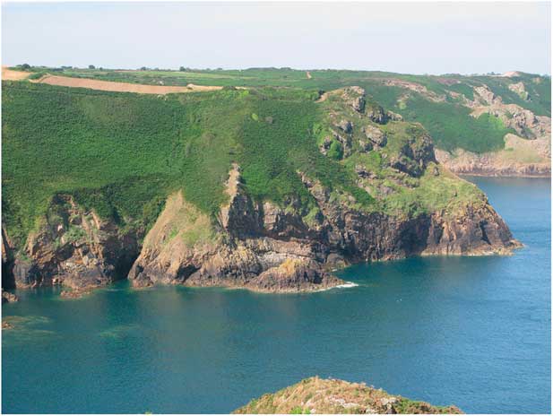
After Canal du Squez, the collection from Col de la Rocque is second largest in Jersey, numbering nearly 2500 pieces in total. Most of this material is Mesolithic, however a substantial component of later prehistoric material is present, including two transverse arrows, a barbed and tanged arrow, thumbnail scrapers and a fragment of Les Fouillages style Neolithic pottery. Many – though not all – microliths and bladelets are patinated, while obviously later prehistoric material is unpatinated.
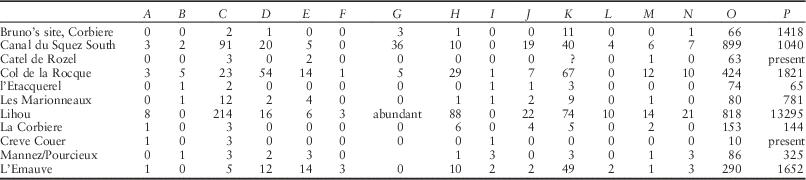
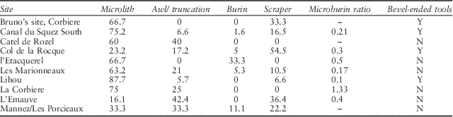
The collection from the site is recorded in Table 3. Of the 23 microliths, nine are scalene triangles, with the remainder obliquely blunted points and a single basally modified piece (Fig. 9). The basally modified piece is relatively elaborate and highly reminiscent of sites from the Cotentin, with examples known from Auderville and Flamanville (Ghesquière et al. Reference Ghesquière, Lefèvre, Marcigny and Souffi2000). This high proportion of triangles suggests that at least some of the occupation at Col de la Rocque occurred during the second half of the Boreal. The presence of microburins indicates on site microlith manufacture.
Microliths from Col de la Rocque
Composition of Channel Island Mesolithic Assemblages

A=awl/borer; B=burin; C=microlith; D=scraper; E=truncation; F=core tool; G=bevel-ended tool; H=miscellaneous retouch; I=burin spall; J=microburin; K=core; L=tested nodule; M=crested blade; N=core tablet; O=bladelet; P=debitage
Of the other tools, scrapers dominate; however most of these are likely to be later prehistoric in date; in general they are unpatinated. Truncations, usually oblique examples, are the next most common tool. These are common in surface collections with a significant Mesolithic component. Five burins are present. Though these may be Mesolithic, burins are also present in Neolithic assemblages, and seem relatively rare on middle Mesolithic sites of the Cotentin. Three awls were also recorded.
Core reduction is focused on the production of bladelets and fine flakes. As at Canal du Squez, cores tend to be single platform examples on beach pebbles, with reduction proceeding part of the way round the core, leaving a cortical back. Also common are two-platform pyramidal cores, with one primary platform, and a second platform at 45° located at the apex of the pyramid. In contrast to examples from Guernsey and the Cotentin, cores on flakes, using the ventral surface of the flake as the platform are uncommon. Some flake cores are present where bladelets and flakes are removed from the lateral edges of a large, thick flake, using a truncation on the distal end of a thick flake as a platform. These pieces are not patinated so may be later in date. Cores show careful preparation, with neat platform abrasion and overhang removal used to trim the platform/core face angle. Core tablets demonstrate platforms were rejuvenated. Blades show neat platform abrasion; this is less common on flakes. Crested blades indicate this method was sometimes used to initiate blade production.
Les Marionneux
Les Marionneux, St Mary’s, is on headland overlooking the Devil’s Hole on the northern coast of Jersey (Fig. 2). The site is only 0.6 km from Col de la Rocque and the two sites are intervisible (Fig. 10). Lithic material has been recovered from field 168 by J.M. Storey and Brian Phillipps. The majority of lithic material at Les Marionneux is patinated and the small amount of non-patinated material seems mainly of later prehistoric date. As a result, only the patinated material is included in counts for this site. In total 894 pieces have been recovered.
View of les Marionneux from Col de la Rocque

Twelve microliths are present in the collection: three obliquely blunted points, two partially backed pieces, two basally modified pieces, and four scalene triangles, indicating a likely late Boreal date (Fig. 11, Table 3). Two microburins were also recovered, indicating microlith manufacture at the site. Beyond the microliths a range of tools was recovered. Truncations are the most common tool, with four examples. The three oblique examples could have been used as borers or gravers. One burin is present in this collection, though this may also have served as a bladelet core. Two scrapers were found; one an end scraper, the other a core/scraper. In all, the assemblage indicates a wide range of activities were carried out at the site. Burnt material is also present in large quantities, possibly indicating hearth debris.
Microliths from Les Marionneux

Cores are mainly single platform examples with reduction part of the way round and a cortical back. One core has an anterior crest and the presence of a crested blade in the collection indicates that formal methods of core reduction were sometimes used, even on relatively poor quality beach pebbles. Cores tend to display platform abrasion and overhang removal. While regular bladelet cores are present, other cores are more irregular in their flaking. Bladelets are common in the assemblage. These tend to be 5–8 mm in width and less than 50 mm in length. Only two exceed 50 mm. Some large flake debitage is present, often corticated, indicating the early stages of core reduction are present.
L’Etacquerel
A small assemblage of Mesolithic flint derives from an unknown location in the vicinity of l’Etaquerel battery (Fig. 2). At least some of the collection was collected in 1919 and may be the ‘flint scatter area’ in field T632. This is another cliff-top coastal location, around 1 km to the west of the larger site of Câtel de Rozel. Two microliths, both obliquely blunted points, and a possible microburin are present in the collection (Fig. 12, Table 3). Also present are three cores, an opposed platform bladelet core, a pyramidal core, and a single platform core. Bladelets number 74, while 65 flakes and fragments are present. Debitage displays evidence for careful preparation with platform abrasion and narrow butts. The l’Etacquerel collection is unusual for a fieldwalked assemblage from the eastern part of the north coast in that it does not appear to have a significant later prehistoric component. The only microliths recovered are obliquely blunted points, which could suggest an Early Mesolithic date; however the small number recovered and the continued presence of obliquely blunted points in Middle Mesolithic contexts urges caution. An additional obliquely blunted point has been recovered from la Tête des Hougues, which is the name given to the headland adjacent to l’Etaquerel.
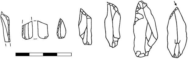
Microliths from: Câtel de Rozel (top row 1–2); Rozel (3); l’Etacquerel (4–5); la Tete des Hougues (6); Bruno’s site, Corbière (bottom 1–4); ‘100 Foot Gulch’ (5); Tete de Quennevais (6)

Câtel de Rozel
Câtel de Rozel is a promontory fort, on the Rozel headland in the north-east corner or the island (Fig. 2). The fort’s ramparts were constructed in the Late Bronze Age/Early Iron Age, over an earlier bank of possibly Late Neolithic/Early Bronze Age date (Cunliffe Reference Cunliffe1992). A large lithic assemblage of mixed date derives both from fieldwalking and excavations of the earthwork undertaken by Barry Cunliffe in 1988–1990. Later prehistoric flintwork dominates the collection, but Mesolithic material has also been recovered. Two microliths are present, a backed bladelet from the excavation of the earthworks, and a basally modified piece from an older collection from the area. An additional microlith in Jersey Museum is recorded as recovered from the Rozel area (Fig. 12). These pieces are patinated, as is fine flake and bladelet debitage from the collections, in contrast with obviously later prehistoric material which is unpatinated. It seems that in this corner of this island patina is a good indicator of Mesolithic date. The microliths suggest a Middle Mesolithic date for the occupation.
Mesolithic debitage is concentrated in particular areas of Câtel de Rozel. Amongst the Oxford University fieldwalking, Mesolithic material comes from field 567/8 (Fig. 13). Systematic fieldwalking of the area was also undertaken by the Société Jersiaise (Matthews Reference Matthews1984). A scatter was recorded in this same field and into the adjacent field, with the greatest amount of material deriving from a slight rise. Mesolithic material was also recovered during the Oxford University excavations of the earthworks. This derives mainly from loessic soil and turf layers used to construct the rampart (Cunliffe Reference Cunliffe1992). This loess seems to have been removed from the interior of the fort, to the east of the rampart. It thus is likely to derive from a similar area to the field 567/8 scatter, which is also to the east of the rampart. Additional Mesolithic material was recovered from trench 8, which was excavated within the interior of the fort, to the east of the field 567/8 scatter. All this material was within the ploughzone, as ploughing had occurred down to bedrock in this area (Cunliffe Reference Cunliffe1992).
Location of Mesolithic material (shaded area) at Câtel de Rozel (after Cunliffe Reference Cunliffe1992)

Bruno’s site, Corbière
In contrast to the preceding sites, Bruno’s site is located in the south-west corner of the island, in the Corbière area, close to a disused desalination plant. The collection numbers 1500 pieces and is mostly of Mesolithic date, though some later material also appears to be represented. Amongst the collection are four microliths, an obliquely blunted point and two narrow triangles with a transverse truncation, and a small geometric fragment (Fig. 12). In Normandy and the Channel Islands triangles with straight truncations appear to be common in late Boreal assemblages, and their presence is likely to indicate a similar date for this site.
Apart from the microliths, tools are relatively rare in the assemblage. Only a scraper and an irregular retouched piece are present, and though such pieces are found in late Boreal assemblages, they are also common on later prehistoric sites. Blades and bladelets are lower in frequency than other assemblages on the island. The presence of large cortical flakes may suggest a specialised function for this site – the decortification and shaping of cores, with relatively low levels of plein debitage.
‘100 foot gulch’, Blanches Banques
Mesolithic material has been collected eroding from this blowout in the Blanches Banques area of Les Quennevais by Brian Phillipps. Though significant quantities of the lithic collected by Mr Phillipps are Mesolithic in date, Neolithic material is also common in the blowout, as indicated by finds of pottery and a shale bracelet. Amongst the Mesolithic material is a microlith, an unfinished microlith fragment, an oblique truncation and a couple of scrapers (Fig. 12). Debitage numbers 618 pieces of which 41 are bladelets. The microliths recovered suggest a broadly Middle Mesolithic date.
Smaller collections
In addition to the above sites, Mesolithic material can be recognised at several other locations on the island. On the north coast, around 1 km to the east of Grosnez, lithic material has been recovered from Plemont by Attenborough, Hill, Keeley, and Rybot in 1921. Though no microliths are present in the collection, the tools recovered and methods of debitage suggest a Mesolithic date for at least some of this material. One burin is present, as are two oblique truncations, and these latter in particular are common on Mesolithic sites in Jersey. Fine flakes and blade debitage was also recovered. Also on the north coast a collection from the Mourier Valley, immediately north of Les Marionneux, contains fine flakes and bladelet debitage.
In the west of the island, a microburin and a truncation have been recovered from St Ouen’s Mill and an obliquely blunted point and a neat bladelet core from le Tete de Quennevais (Fig. 12). In the south, Mesolithic material has also been recovered from Portelet Common.
Guernsey
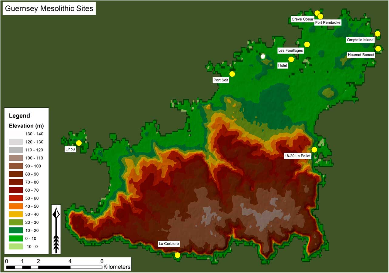
Guernsey, the second largest of the Channel Islands, has an area of 65 km2 (Fig. 14). The island consists of a plateau, capped by loess deposits, with cliffs up to 100 m above sea-level in the south. The plateau drops down to coastal plains in the north and the west, where there is a series of bays and promontories (Sebire Reference Sebire2005).
Location of Mesolithic sites in Guernsey

While Kendrick suggests Neolithic people were the first colonisers of Guernsey (Kendrick Reference Kendrick1928, 8), he also noted the presence of chipping floors containing retouched ‘pygmy’ flints at La Corbinerie (probably la Corbière; Sebire pers. comm.), and from the central cist of the megalithic remains at l’Islet (ibid., 39). He also records knapping stations containing chips and small blades – though no retouched ‘pygmies’ at Lihou and Crève Coeur. All these sites are now understood to preserve Mesolithic remains, and further examples were added through Patton’s synthesis (Patton Reference Patton1993). More recently a number of sites with Mesolithic material have been discovered by Guernsey Museum in the course of excavations in advance of development (Sebire Reference Sebire2005).
Lihou Island (GU582)
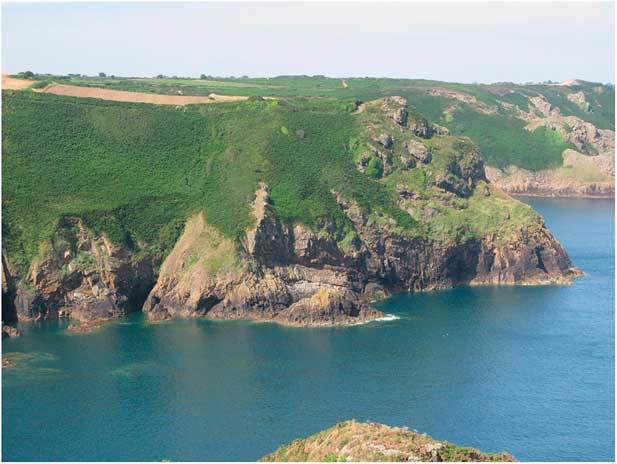
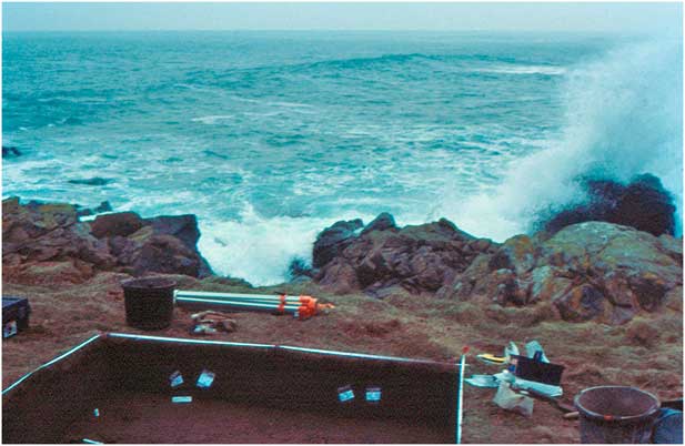
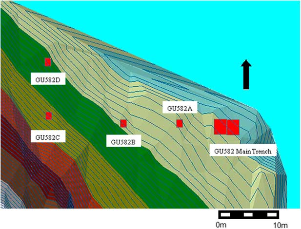
Lihou is a small tidal island situated off the west coast of Guernsey. Site GU582 is located on a low sea cliff on the northeast tip of the island (Figs 14 & 15). The presence of material of likely Mesolithic date on Lihou was first mentioned by Kendrick (Reference Kendrick1928, 39) in his survey of the archaeology of Guernsey. This material may have derived from the current site GU582; however lithic material can be found more generally across Lihou, so another source is possible. Collections of surface material by Ruse in the early 1960s, numbering more than 1000 pieces, revealed the presence of a series of lithic scatters on Lihou. One of his clusters of material was recovered from the cliff face between 244789 and 244792, thus encompassing the GU582 site. Lihou is also mentioned as one of the most prolific sites in the Channel Islands for worked flint in the surveys of the geologist David Keen, who undertook a study of Guernsey in 1972–3 (Keen Reference Keennd). Keen collected material from east side of the north-east tip of Lihou (244792), describing how the site was ‘under periodic attack from the sea and many of the flints were collected loose at the foot of small cliff sections.’ In this area he noted the in situ presence of worked flint in soils of wind-blown sand, extending up to 0.6 m below the current ground surface. Further material was located by Mike Hill on 19 April 1981 at 244791, in the general vicinity, but possibly a bit to the south, of the GU582 site. His collection, which includes four microliths, is consistent with a Middle Mesolithic date and similar to the types recovered from GU582.
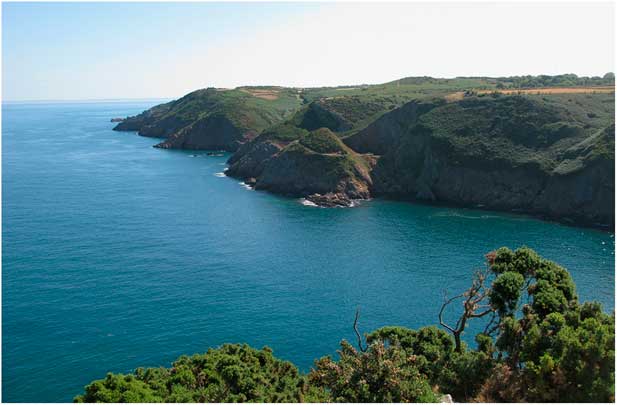
View from Lihou GU582

In 1999, 20 pieces of flint were collected from within a few metres of an eroding cliff edge by Mick Atha who reported these finds to Dave Lane. The latter then located a flint horizon exposed in the cliff and has been instrumental in promoting awareness of this material – and the threats to its existence caused by marine erosion – to a wider audience, leading to the site’s subsequent excavation in 2001–2003. Since 1999 Lane and other members of the Guernsey Museum Archaeology Group have been monitoring the erosion of the cliff edge. With his kind permission, his material recovered from these erosion surfaces has been included in the main site analysis. In addition members of the group have located other findspots on Lihou, to the southwest of GU582, by the weather station and also in the vicinity of the priory.
EXCAVATIONS 2001–3
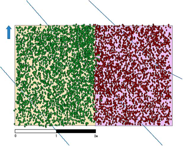
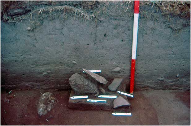
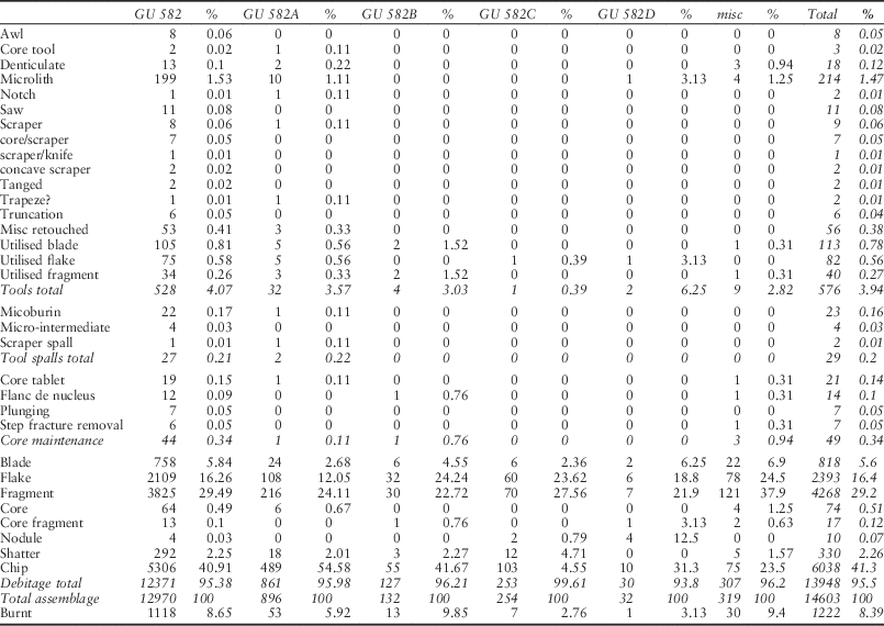
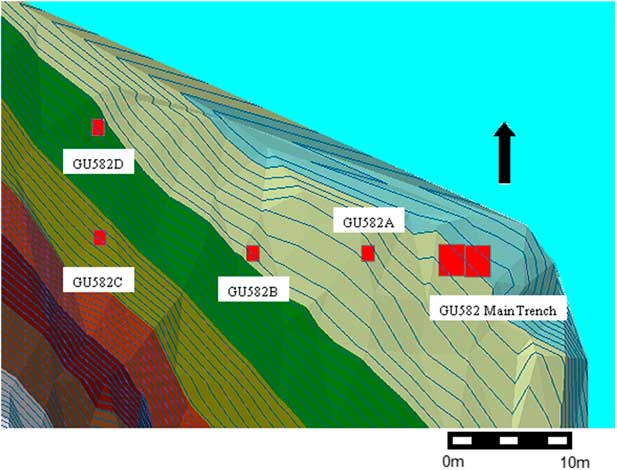
Excavations undertaken by Tim Schadla-Hall comprised a trench, measuring 4×2 m, excavated over three seasons. In 2003 four further test-pits measuring 0.5 m across were excavated to the north of the main trench (Fig. 16). Nearly 15,000 pieces of worked flint were recovered from this small area of excavation (Fig. 17), of which the vast majority derived from the main trench (Table 4). Intensive flintknapping activities must have occurred in this area and are associated with a cluster of large burnt stones, which may represent a partially destroyed stone-built hearth (Fig. 18). A radiocarbon date of 8310±39 Bp (OxA-15198; 7497–7192 cal BC) derives from burnt hazelnuts associated with this structure.
Lihou trench locations
Density of lithic material in the main trench

Lihou stone structure

Composition of the Lihou Assemblage

Geoarchaeological investigations
In addition to the sequences exposed in test-pits, the adjacent cliff section provided an exposure where sediments could be recorded. Below the turf and root-matter were layers of fine grey, compact windblown sand, around 250 mm thick, which contained the Mesolithic material. Beneath this, at the base of the test-pit, and in the cliff sections were layers of pale yellow/grey fine silts, interpreted as loessic deposits, which may be reworked.
Micromorphology, undertaken by Richard Macphail, on the implementiferous deposits, indicates that they are composed of aeolian coarse silts and fine sands accompanied by humic A-horizon formation. Acidic surface soil conditions are implied by the arrangement of relict organic sediments in the lower contexts. Human activity is indicated by anomalous coarse grained rock fragments and compacting, both likely to have been caused by trampling.
Worked flint
The material recovered from GU582 is typologically Middle Mesolithic date. This accords well with the radiocarbon date, placing it in the second half of the Boreal. The raw material employed was almost always flint, which varies in colour from speckled grey to brown to opaque grey/white. This is a more restricted set of colours than at Canal du Squez. A moderate proportion of the assemblage has undergone a certain degree of patination. The material ranges in quality from translucent fine grained material to courser flint with a more cherty appearance. A handful of pieces of worked quartz are also present. As with other Channel Island sites, the flint derives from beach pebbles. The majority of the material is of relatively poor quality, even in comparison with other Mesolithic sites, suggesting a lack of selectivity in collection strategies. Internal flaws (mainly marine fossils and quartz crystals) are relatively common. The choice of beach pebbles as raw material and their abundance close to these sites permitted knappers to be relatively wasteful.
Technology
The technology employed can be broadly characterised as expedient, though more attention was paid to the production of certain blanks and artefacts. In general preparation was kept to a minimum and techniques to maintain and prolong the life of the core are rare. Mistakes, unsurprisingly given the poor quality of the raw material, are common. Siret flakes and step and hinge fractures are frequent. The majority of the flintknapping appears to have been undertaken with a soft stone hammer, though a hard hammer was sometimes used, particularly for the removal of large cortical flakes. The many stones that were brought to the site, including the bevel ended tools, would have been suitable hammerstones. A few fine bladelets display a diffuse bulb of percussion and a lip, which could indicate occasional use of a soft hammer.
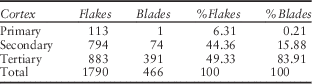
An important task at the site appears to have been the shaping of unmodified beach pebbles into cores. Ten tested and partially reduced nodules were recovered from the excavations. Large, thick, cortical flakes are common and primary flakes comprise 5% of the total assemblage (Table 5). In all 43.6% of all complete flakes and blades are cortical or partially cortical. Many of these pieces display thick plain or cortical butts and have rarely undergone any preparation, such as abrasion or overhang removal, the aim simply appears to have been to remove natural protuberances from a nodule and produce a core suitable for plein debitage with as little effort as possible and without any object to conserve raw material. However these thick supports were not simply discarded, as several were used for the production of large denticulate scrapers.
Representation of Cortical Pieces in the Lihou Assemblage

The lack of attention to preparation continued into plein debitage. True crested blades were never used to initiate knapping, instead knapping proceeded along natural ridges and ridges created by previous removals. Few pieces can be grouped as core maintenance pieces, designed to maintain and prolong the life of the core. Core tablets are relatively rare (21 examples) and the presence of some multi-platform cores (23) suggests that knappers moved to a new platform as frequently as rejuvenate the old one. Step factures tended to be removed through detaching a thick flake from the same platform rather than an opposed one, a technique that is less effective. Failure to remove step fractures led to the abandonment of several cores.
The majority of cores are single platform examples, knapped part of the way round, and with a cortical back. Only two were worked around the whole circumference of the core. Of these single platform cores, five are pyramid. Eleven cores have two platforms, of which three have opposed platforms, six have platforms perpendicular to each other, two at angles of 45°, and three have knapping either side of a ridge. Nine are multiplatform examples, four with knapping either side of a ridge and five more irregular examples. An idiosyncratic feature of the Lihou assemblage is the establishment of cores on large thick flakes. Knapping was initiated using the distal part of the ventral surface of the flake as a platform. This appears to be one way of creating a flat platform and a flaking angle of less than 90°. The use of large flakes for cores appears a feature of the northern French Middle Mesolithic, however the particular way the Lihou flakes were used appears more typical of the Middle Mesolithic sites of Brittany (Marchand Reference Marchand2005) and Basse-Normandie (Ghesquière et al. Reference Ghesquière, Lefèvre, Marcigny and Souffi2000).
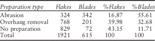
Debitage is in the style ‘Coincy’ as defined by Rozoy (Reference Rozoy1978). This is broadly laminar, but without the careful preparation of the ‘Montbani’ style. Blades tend to have one rather than two arises. Flakes and blades from plein debitage display a varying amount of preparation, a attribute also evident at other middle Mesolithic sites in Northern France, and, as Lefebvre reports for the site of Flamanville, preparation has in general been kept to a minimum (Ghesquière et al. Reference Ghesquière, Lefèvre, Marcigny and Souffi2000). Often pieces would have little or no preparation, or overhangs would simply be removed (see Table 6). Few pieces have more extensive platform abrasion. Blades are much more likely to have this type of preparation than flakes (55.6% as opposed 16.9%), indicating greater concern with blade production. Blades are also less likely to bear cortex than flakes (only 16.1% have cortex compared to 50.7% of flakes). Though some fine blades and bladelets are present in the assemblage, these are relatively rare (c. 5%), in comparison with northern French sites of a similar date, where frequencies of bladelets seem to vary between 20% and 30%. It could be argued that, given the small area excavated, bladelets could have been removed to another area of the site for preparation or use, or even removed from the site to be used elsewhere in the landscape. However few of the cores even display extensive bladelet scars; instead the removal of fine, and less fine flakes, appears to have been more common.
Preparation of Flakes and Blades from Lihou

Tools
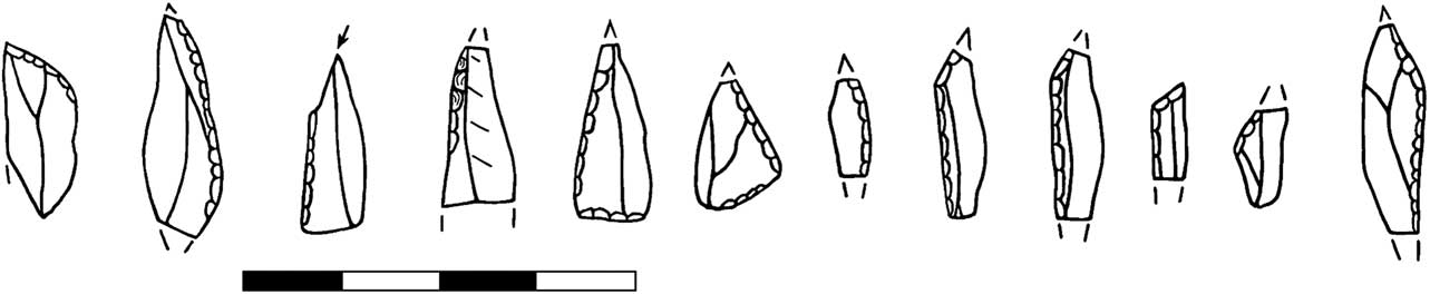
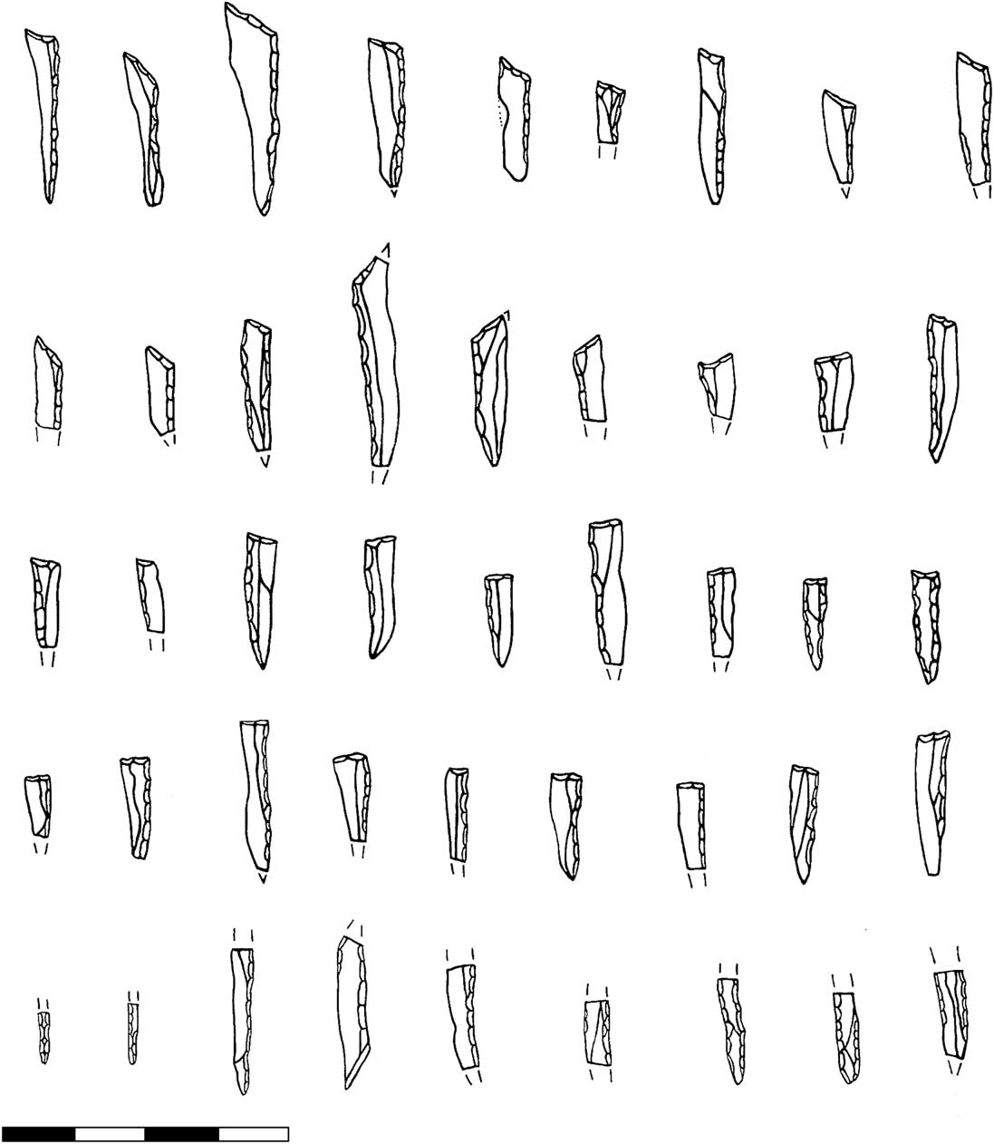
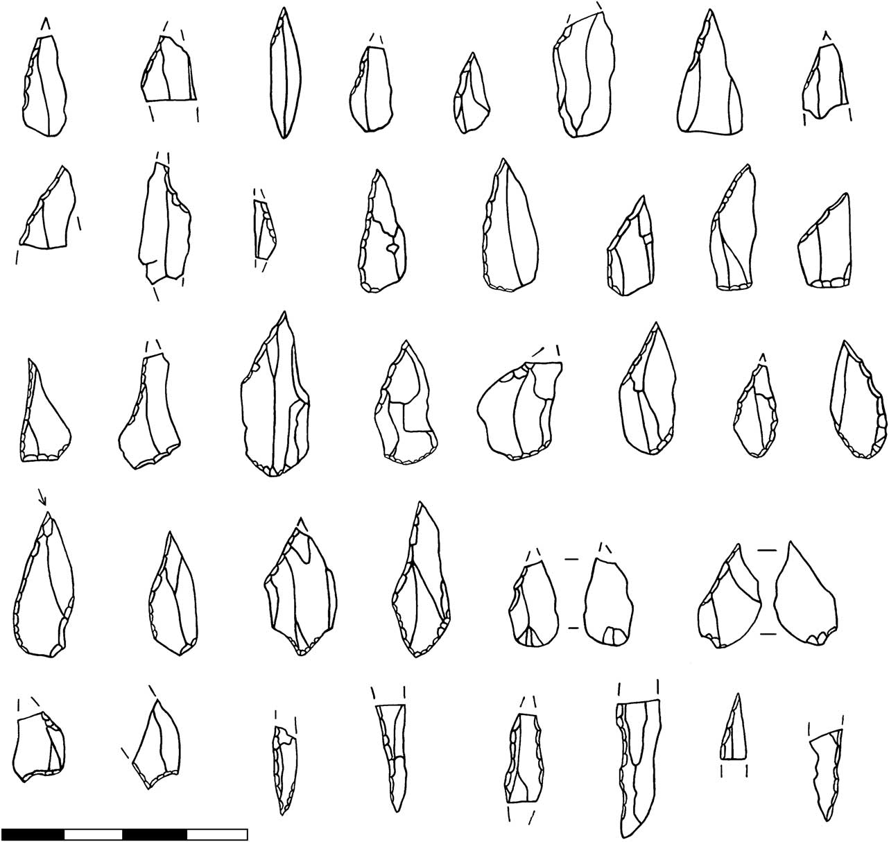
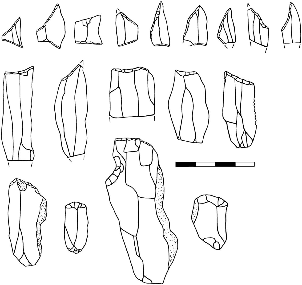
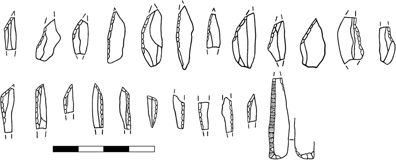
A similar expedience is evident amongst many of the tools. With a few exceptions, these tend to be relatively amorphous pieces, lacking clearly defined forms. Awls, microliths, and truncations were well made. Scrapers, denticulates, and core tools seem more expedient, with amorphous forms that grade into each other. Microliths are by far the most common tool type, with 219 examples (Tables 3 & 4; Figs 19 & 20); other types are relatively rare. Scalene triangles are the most common microlith type with 29 examples (Fig. 19). Most scalene triangles have two retouched edges, though the third edge can also be partially or totally retouched. The dominance of scalene triangles fits well with the typology constructed by Ghesquière et al. (Reference Ghesquière, Lefèvre, Marcigny and Souffi2000), in that the frequency of scalene triangles appears to increase in the second half of the Boreal. On many of the triangles the angle begins to approach a right-angle. These grade into small truncated narrow backed bladelets, which are represented by eight examples (Fig. 19). Seven of these have only one edge backed, the last is much smaller, narrower and is double backed. This last type is common amongst the Breton Bertheaume group of Middle Mesolithic sites of northern Brittany. Truncated bladelets with a single edge backed are seen at the Cotentin site of Rozel, station 56 (Audouard Reference Audouard1986); this site is undated but considered to belong to the late Boreal. Truncated backed bladelets also make up an important component of the microliths from RMS assemblages with feuilles de gui, characteristic of the Middle Mesolithic after c. 7500 cal BC west of the Seine. The date of Lihou suggests truncated backed bladelets can also perhaps be considered a marker of the later part of the Middle Mesolithic east of the Seine. Narrow backed blades without this truncation, an important type in Normandy Boreal assemblages (Ghesquière et al. Reference Ghesquière, Lefèvre, Marcigny and Souffi2000) are poorly represented at Lihou. Five examples were recovered, all fragmentary; some may be broken triangles.
Scalene triangles and truncated narrow-backed bladelets from Lihou

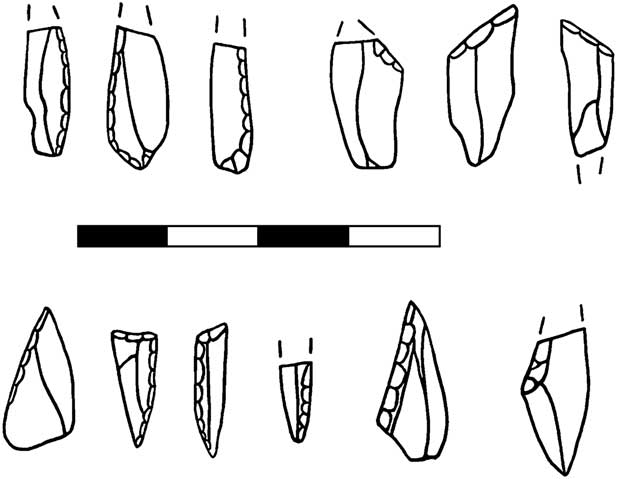
Obliquely blunted points & basally modified microliths from Lihou

Obliquely truncated points are the next most common type amongst the microliths (Fig. 20). These are represented by 22 pieces. Points with basal retouch are represented by 13 examples. Both obliquely blunted points and backed bladelets can have this additional basal modification which can consist of a straight basal truncation or a rounded base. Basal retouch varies from abrupt retouch across the whole base, to very slight retouch, often on the ventral surface. A large number of microliths (33) are too fragmentary to assign to a particular category. Of these, six are fragments of geometric microliths and thus would have originally been either scalene triangles or backed blades. Two are fragments of either obliquely backed points or basally modified points. In total 23 microburins were recovered, along with four micro-intermediates. These indicate on-site microlith production.
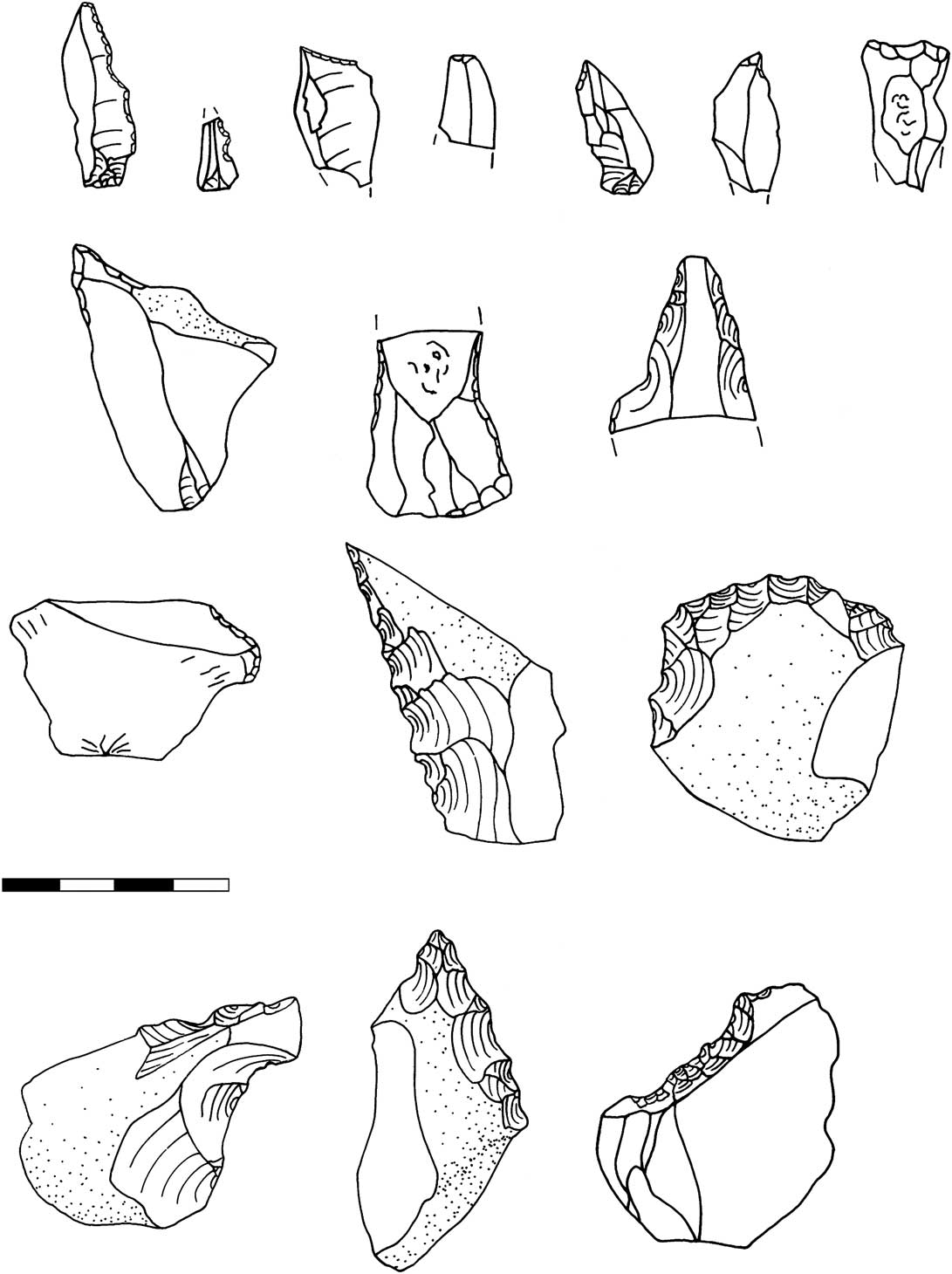
Notches and denticulates are the second most common tool category, represented by 20 examples (Fig. 21). Most of these are crude, heavy-duty pieces made on thick flakes, cores, or shatter fragments. Thick cortical flakes were frequently selected as supports for these tools (in 13 cases). Also present are three finer denticulates made on bladelets. Eleven saws or serrated pieces were recovered. The majority of these (seven) are on bladelets, two on flakes and two are fragmentary.
Tools from Lihou
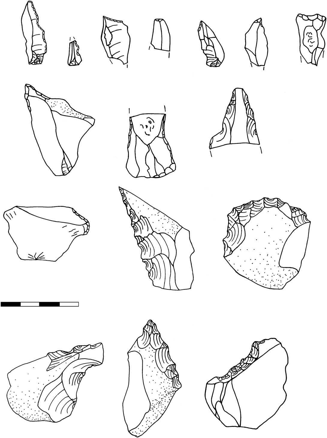
Eight awls/borers were recovered (Fig. 21). These consist of single or convergent oblique truncations. Three are on bladelets, four on flakes and one fragmentary. These grade into the truncation category, of which were recovered five straight and one oblique truncation. Two are on blades and three on flakes, including a thick semi-cortical flake. The final example is a fragment. Scrapers, of which eight were recovered, range considerably in morphology. One end scraper on a blade was recovered, but the others are more irregular in form, including a flake, a ‘nosed’, and a side scraper. Two scraper spalls were also recovered, including one from a denticulated scraper, indicating production/resharpening of these artefacts at the site.
A characteristic of the Lihou assemblage is the presence of amorphous tools which are difficult to categorise. These encompass 56 miscellaneous retouched pieces, several which have more extensive retouch. This includes five partially or entirely bilaterally retouched pieces. Three core tools were recovered, mainly nosed pieces, up to 60 mm in length (Fig. 21). It is not impossible some of these represent heavily worked core fragments (see Marchand Reference Marchand2005 for a discussion), and it is worth noting that there is similar ambiguity between some cores and artefacts in the denticulate scraper category, which were also made on thick flakes. The large amorphous tools from Lihou are similar to pieces recovered from the Cotentin site, Auderville-Roc de Gîte. Auderville is a similarly intensively occupied site, with occupation focused around stone features, and has a similar radiocarbon date to that of Lihou (Ghesquière et al. Reference Ghesquière, Lefèvre, Marcigny and Souffi2000).
Imported stone
Quantities of imported stone were also recovered from the site. Unfortunately the majority of this was inadvertently destroyed prior to analysis, during building work on the Institute of Archaeology basement. The material recovered consisted of hearth stones, many of which had been heated to point of fragmentation. Also present were a series of elongated bevel-ended tools. As with similar examples recovered from Jersey and the Cotentin Middle Mesolithic sites, some of these appear to have been used as hammerstones, others were smoothed by wear.
Activities on Lihou
Flintknapping was a major activity at GU582. People carried flint pebbles from the beach to the site. Here they removed the cortex from these nodules and worked them into manageable cores. Both blades and flakes were produced during plein debitage, with in general greater care taken to produce blades. Large numbers of microliths were produced on site, and composite tools repaired. Scrapers were manufactured or maintained. Certain activities were undertaken which required the production of heavy duty denticulated pieces and the use of bevel-ended tools. Food preparation and cooking are also likely to have taken place, as indicated by quantities of carbonised hazelnut shells. Unfortunately bone is not preserved in the acidic soil.
There is some evidence for spatial variation in activities. The main trench appears to have been the centre of activities, though flint densities remained high as far as (and no doubt beyond) the current cliff edge. The main trench was the centre of microlith production and retooling, which is likely to have taken place around a hearth, which would have been needed for mastic production. Processing of hazelnuts, and thus cooking more generally may also be associated with this hearth. The density of lithic artefacts in the main trench indicates that it is likely to represent a palimpsest, though the lithic material indicates that most of this reoccupation took place during the second half of the Boreal. This repeated occupation appears focused on a cluster of large stones which may indicate a hearth area that was re-used and remodified over many years.
Moving north, evidence for activity declined, from a density of around 4000 pieces of flint per m2 in the main trench to 32 pieces in GU582D. Microliths also decline significantly: there were 199 in the main trench and ten in GU582A, but both GU582B and C lack microliths entirely and GU582D has only one. Quantities of burnt material also reduced significantly moving west, suggesting the main trench was also the focus of heating/cooking activities. Material in GU582A seems to represent the edge of the activities occurring in the main trench, both are relatively similar in their artefact composition. Smaller scale and short term tasks seem to be represented to the north, probably short-term core reduction activities.
La Corbière
La Corbière, Forest, probably the site Kendrick erroneously refers to as La Corbinerie (Sebire & de Jersey pers. comm.), is a surface collection represented by 316 pieces (Table 3) and, after Lihou, the largest collection of Mesolithic material in Guernsey. The site is on a headland on the western part of the north coast of the island, overlooking the sea and has been collected now for over a century. Any admixture with later material appears relatively minor, and seems confined to the small Ruse collection, which is not included in counts. Three microliths have been recovered from the site (Fig. 22): one simple obliquely blunted point and two backed bladelets (one of these is missing, but is illustrated by Kendrick). This is a very small collection, consistent with a Middle Mesolithic date, but may be slightly earlier than Lihou. Microlith production seems to have been an important task, as three microburins and a micro-intermediate (unsnapped microlith/microburin) were also recovered. Also present amongst the tool component was a fine awl, the tip formed by convergent truncations, two amorphous retouched pieces, and two flat, elongated pebbles, which appear to have been used as hammerstones. This latter form is also found at Lihou and is common at Mesolithic sites in Normandy. In terms of technology, the La Corbière assemblage seems to demonstrate more care and preparation in knapping in comparison to Lihou. Blade percentages are very high, but this may be because this is a selectively collected assemblage. Core technology employs mainly single platform cores, worked part of the way round the platform, including an example on a flake. Crested blades are common in comparison to Lihou, including examples that appear to have been used to initiate knapping, perhaps suggesting an earlier date for this collection.
Microliths from Guernsey sites: La Corbiere (1–3); l‘Islet (4); Fort Pembroke (5)

Creve Coeur
Creve Coeur, on the north-east coast of the island, is a second Guernsey site which has been described in the literature as Mesolithic (Patton Reference Patton1993). This collection however appears rather more mixed in date. Two microliths have been recovered from the site (a basally modified piece and a narrow backed bladelet), also an awl and a burin spall, all of which are compatible with a Middle Mesolithic date (Fig. 22). Furthermore the assemblage of 289 pieces in Guernsey Museum contains ten finely worked bladelets. However bipolar knapping using an anvil is a common feature of the collection and this technology is prevalent amongst later prehistoric assemblages from the Channel Islands.
Smaller collections
Microliths are known from the Neolithic long mound at Les Fouillages (Ghesquière pers. comm.). These were found beneath the first phase of the monument in a deep forest soil, with tree-throws indicating the presence of dense woodland (Sebire Reference Sebire2005). Microliths have also been recovered from Port Soif (Keen collection), Fort Pembroke (Atha collection), and a possible fragment from Hommet Benest (Atha/Sebire collection), while an additional example is figured in Kendrick (Reference Kendrick1928, fig. 13) from l’Islet. A small amount of Mesolithic material may also be present at l’Eree. A bevel-ended tool has been recovered from Omptolle Island and at 18–20 Le Pollet, St Peter Port, a recent rescue excavation yielded a small microblade fragment and dihedral burin from layers of colluvium. The technology tends to suggest a mixed date for these collections, with quantities of Mesolithic material relatively small. Only Port Soif and Hommet Benest perhaps seem to have more significant proportions of Mesolithic debitage. The microliths recovered from these smaller sites tend to be fairly fragmentary, Les Fouillages has the largest collection (5), consisting of obliquely truncated points and backed bladelets (Ghesquière pers. comm.), other sites tend to have single examples of obliquely blunted points or backed bladelets. All these sites are consistent with a Middle Mesolithic date, with the possible exception of the microlith from Fort Pembroke which could be Late Mesolithic. Given the fact that simple obliquely blunted points are well represented, and scalene triangles absent these sites could also be earlier than Lihou.
Alderney
Alderney is the most northerly of the Channel Islands and lies only 13 km from the Cotentin peninsula. A strong current is present in the waters between Alderney and the Cotentin, making the stretch of water dangerous to traverse. High cliffs rise to the south and west, while the east is lower lying. Alderney is considerably smaller than both Jersey and Guernsey, measuring just 4.8×2.4 km, and as a result has fewer Mesolithic sites.
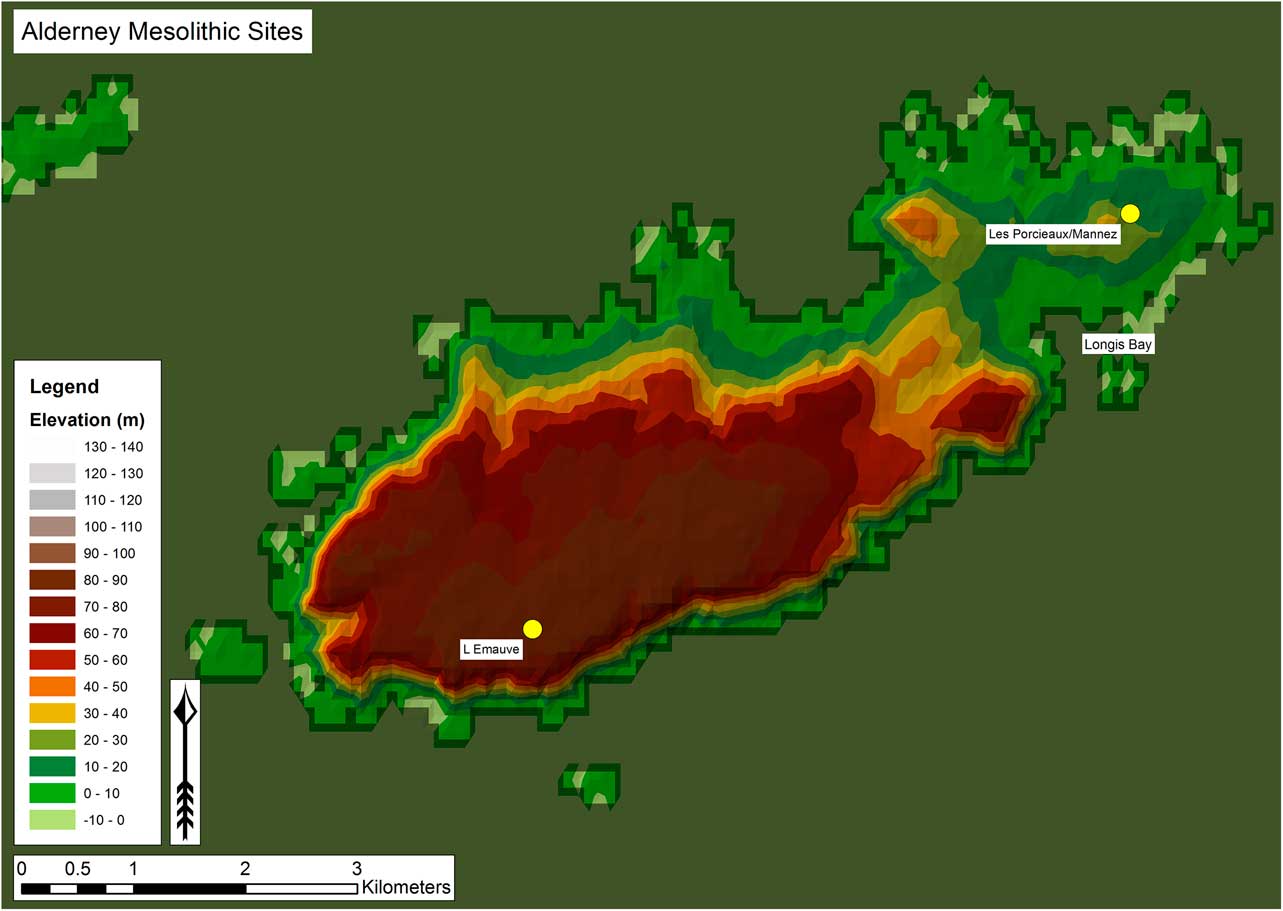
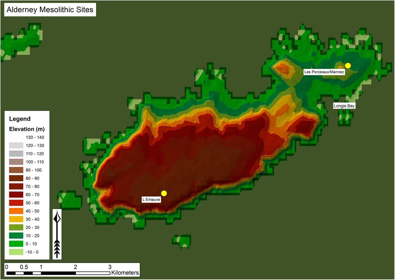
Two major areas of Mesolithic activity have been recognised, in the south-west, at l’Emauve and in the east at Mannez/Les Pourciaux (Fig. 23). These two sites represent Final Mesolithic and Middle Mesolithic settlement respectively. Blade-based material has also been collected from inter-tidal peats at Longis Bay which currently lacks diagnostic tools and may have a Mesolithic, or even an Upper Palaeolithic, component but is most likely to be of Neolithic date. A key feature of the Alderney sites is the larger and better quality raw material present, a result of the closer proximity of Alderney to now submerged primary flint sources, leading to the presence of larger nodules on its beaches (Callow & Cornford Reference Callow and Cornford1986). This has resulted in the presence of a series of larger knapping products than from the other Channel Islands.
Location of Mesolithic sites in Alderney
Mannez/Les Pourciaux
Mannez/Les Pourciaux is an area of high ground overlooking Longis Bay in the east of the island (Fig. 23). Lithic material has been collected by various individuals from ploughed fields or from erosion patches. Also included in the Mannez/Pourciaux collection is material from Mannez enclosure which appears to be of later prehistoric date and is unpatinated, or has a light patina. This material has been excluded from counts. The Mesolithic assemblage, by contrast, tends to have a thick white patina.
The Mesolithic assemblage from the site numbers 431 (Table 3) and is characterised by a series of well-made blades and fine flakes, with fine butts and neat platform abrasion. Crested blades and core tablets are both present. Cores and microliths are rare, though this may be due to lack of recognition by collectors, rather than reflecting Mesolithic activities. Only three cores were recovered, two single platform with cortical backs and a two-platform, with perpendicular platforms. Microliths also number three: one scalene triangle and two basally modified pieces, indicating a Middle Mesolithic date (Fig. 24). Also present are three oblique truncations, two scrapers and a burin. In addition, two burin spalls are present, both showing that the edge of the original flake was trimmed before removal of the spall.
Microliths from Pourciaux/Les Mannez

L’Emauve
L’Emauve is a large spread of material, extending several hundred metres to the north and south of the coastal track in the south-west of the island, just to the south of the airport (Fig. 23). The lithic material has been collected by numerous individuals, both from areas of erosion adjacent to the track and a coastal path to the south and as a ploughzone scatter from a field to the north of the track. The site is to the east of a hanging valley with a convenient water source (Fig. 25). To the east and west are two other areas where lithic material has been collected, Plat Cotil and Sylt, both of which collections appear to be composed of later prehistoric material, though each may have a Mesolithic component. Similarly later prehistoric material appears present at l’Emauve, in particular Early/mid-Neolithic material, though a small amount of unpatinated Late Neolithic/Bronze Age material is also present. Given the similarity of Late Mesolithic and Early Neolithic assemblages in northern France, both in terms of technology and common tool representation, it is difficult to distinguish the extent of Mesolithic and Neolithic material at l’Emauve. The whole coastal area from Sylt to Plat Cotil can perhaps be thought of as a persistent place (Schlanger Reference Schlanger1992; Barton et al. Reference Barton, Berridge, Walker and Bevins1995) throughout prehistory.
Hanging valley, looking down from l’Emauve

Technology
Technology appears focused on the production of blades, bladelets, and large regular flakes. The assemblage is more noticeably focused on blade rather than bladelet production, in contrast to other Channel Island assemblages. This is probably partly chronological, though the larger flint nodules available in Alderney are also likely to be an important contributing factor. Some blades are very regular and characterised by two parallel arrises. This is a feature of Late Mesolithic Montbani style blade production; however the Early Neolithic of the region is also characterised by regular blade production (Pailler et al. Reference Pailler, Marchand, Blanchet, Guyodo and Hamon2008). Blades and bladelets have been neatly trimmed and display thin, plain butts.
Cores are variable in nature. While some well-made bladelet cores are present, more ad hoc flake cores were also recovered. Single platform cores, with removals part of the way round are dominant (25 examples), followed by opposed platform examples (7 examples), and multiplatform cores (5). Most of the single platform cores have cortical backs. Three core tablets are present and a single crested blade indicates more elaborate methods of core preparation were rarely followed.
Large cortical flakes are a common feature of the assemblage, suggesting the importation and shaping of unmodified or tested beach cobbles at the site. Two tested nodules were also present. The valley to the west may have provided a route down to the shore where nodules could be collected.
Tools
In contrast to other Mesolithic sites in the Channel Islands, there is a clearly dominant Late/Final Mesolithic occupation at l’Emauve. This is indicated of a small series of trapezes, which dominate the microlithic component of the site (Table 3; Fig. 26). These consist of three asymmetric trapezes, two lateralised to the left, one to the right. A fourth, symmetric trapeze, though small, is on a thick support and is unpatinated. This could be of either Mesolithic or Neolithic date. An elongated obliquely blunted piece with concave base could also be part of this group, but could equally be of Middle Mesolithic date. A fragment with concave oblique truncation may be a trapeze that has broken during manufacture. A thick isosceles triangle could date to several different stages of the Mesolithic. Triangles are common in Final Mesolithic assemblages, but tend to have inverse, low angle retouch (Artur et al. Reference Artur, Billard, Hervieu, Marie and Dubrulle2008), a feature absent in this example (though its tip is broken). In all, while Middle Mesolithic may be present, the entire microlithic assemblage could fit within the Late/Final Mesolithic. The presence of a large transverse arrowhead indicates a Neolithic presence at the site.
Tools from l’Emauve

The trapezes recovered from l’Emauve bear some similarities to those found in Normandy. They tend, as with other examples to the west of the Seine, to be lateralised to the left, and convexity is common, as in Normandy examples. However no triangles with inverse low angle retouch are present and these are common on Norman sites such as Bieville-Beuville, but rare in the Seine (Artur et al. Reference Artur, Billard, Hervieu, Marie and Dubrulle2008). Artur and colleagues (ibid.) suggest there may be a chronological component to this distinction, with simple asymmetric trapezes belonging to an earlier phase of the Late Mesolithic than triangles with inverse low angle retouch. By contrast, in Brittany, sites with asymmetric trapezes, may post-date those with symmetric trapezes, suggesting l’Emauve could date to a late stage of the Late Mesolithic.
A range of other tools was recovered from the site, of which truncations and scrapers are the most numerous (Fig. 26). As at Middle Mesolithic sites, truncations are common. These can be either oblique or straight truncations, some with a marked concavity. In contrast to truncations from other Mesolithic sites in the Channel Islands, these examples are often made on regular blades, rather than bladelets. Several scrapers were also recovered: several are well made end scrapers, but core/scrapers and denticulated core-scrapers are also present. Scrapers and truncations are found on both Mesolithic and Neolithic sites in the region. A patinated flake amongst the assemblage has been reshaped during a later period into a thumbnail scraper, indicating later prehistoric scavenging of the lithic debris generated in the Late Mesolithic and Early Neolithic.
Two burin spalls are present, indicating activities involving burins on the site even though none was recovered. Though present on Mesolithic sites, burins are more typical of the Early Neolithic of the region (Artur et al. Reference Artur, Billard, Hervieu, Marie and Dubrulle2008). Core tools were recovered from the site. These include a triangular pick and a bifacially flaked fragment. A couple of elongated hammerstones were recovered, however bevel-ended tools, so common on Middle Mesolithic sites in the region, are absent.
Activities
A broad range of activities involving lithic material appears to have occurred at the site. Procurement of nodules from nearby beaches seems to have been an important activity. These nodules were then prepared and reduced on site, and tools manufactured. The presence of two microburins indicates that trapezes were manufactured as well as discarded on site, while two primary burin spalls indicate burin production. As might be expected of a site that was repeatedly reoccupied, a wide range of tools is represented, from projectile points to scrapers, truncations, and core tools, indicating a wide range of activities occurred in the area.
Longis Bay
The only other site with potentially Mesolithic material is that of Longis Bay (Fig. 24). Longis is a large bay that dominates the south-east of the island. Lithic material was collected from inter-tidal peats, exposed after a storm and visible in 2005 and 2006. Much of the material was collected by R. Simonet, who regularly monitored the exposures, though other individuals also recovered artefacts.
The assemblage consists almost entirely of debitage and numbers 106 pieces in total. The artefacts recovered are large in size, even by Alderney standards and almost half the pieces recovered are blades, ranging up to 100 mm in length. Some smaller bladelets are also present. The greater size of the material may be due to its context of collection, with smaller material winnowed by the tides. Technologically, the debitage bears similarities to the l’Emauve assemblage, in the presence of regular well-made blades and flakes. Some of these have neat abrasion, others, though regular, show little evidence for preparation. Butts tend to be thicker than at l’Emauve. Two cores were recovered, one a multi-platform example, the other an opposed platform blade core with a preferential platform. Several blades bear traces of cresting. Only one tool is present, an oblique truncation.
This small assemblage, lacking diagnostic tools, could be Late Mesolithic, Early Neolithic, or Late Upper Palaeolithic in date, or even a mixture of different dates. Technologically the material is most likely to be Early Neolithic, which is supported by a mid-Holocene date for at least some of the Longis Bay peats (Campbell et al. Reference Campbell, James and Renouf2001), though the presence of earlier material cannot be ruled out.
Sark, Herm And Jethou
Little is known of the Mesolithic of the smaller Channel Islands. Just 3.2 km to the east of Guernsey on the small island of Jethou a concave truncation and a blade fragment could be either later Palaeolithic or Mesolithic in date. On the neighbouring island of Herm, a small series of well-made bladelets and flakes, found at Le Monceau appear Mesolithic in date.
Mesolithic Activities In The Channel Islands
Most of the Channel Island Mesolithic sites are surface scatters with a later prehistoric component and, given the uncertainty associated with the correct chronological attribution of certain tools, particularly scrapers, it is difficult to discern the full range of activities taking place during the Mesolithic sites. Using a modified form of Mellars’s (1976) basic tool frequencies, it seems that most sites are microlith dominated (Table 7). Several (Canal du Squez, Col de la Rocque, l’Etaquerel, les Marionneux, Lihou, and la Corbière) have microburins, indicating widespread microlith manufacture on the islands. Only Col de la Rocque and l’Emauve fit the definition of a balanced assemblage, with relatively equal numbers of awls, burins, microliths, and scrapers. Lihou seems the most securely microlith dominated assemblage, yet in reality is a lot more varied, however this variability is manifested through the large amount of amorphous retouched pieces, (88) which, from their morphology, seem suited to a variety of different tasks. Overall the assemblages reveal that microlith production and use were important tasks on sites in the Channel Islands thus far discovered. At no single site though are microliths the only tool recovered, other tasks were always undertaken at the same time. The evidence from Lihou, composed of varied activities, extremely high lithic densities, and structural evidence in particular suggests perhaps residential or longer lasting occupation. The evidence from Lihou is similar to that from the Cotentin site of Auderville-Roc de Gîte. This site also yielded vast quantities of lithic material, with 100,000 pieces recovered over an area of 130 m2. These two sites perhaps point to the presence of a logistical system of site organisation, at least in the mid-late Boreal. It is important to remember though that all sites are likely to be palimpsests and thus were probably reoccupied at different times for different purposes.
Essential Tool Frequencies of Key Sites

Persistent places
Many Mesolithic sites in the Channel Islands, particularly in Jersey, tend to be located on the top of relict sea cliffs, created in earlier inter-glacials. During the time of occupation, though the sea might be some distance away, the high cliffs would give good views over a shrinking coastal plain, dissected by river valleys (Table 8). This pattern may be partly taphonomic: sea cliffs are areas of erosion; thus these sites are more likely to be discovered than those in other areas, such as inland valleys covered by alluvium, and low-lying coastal sites are likely to have been inundated. However there is evidence to suggest the cliff top location is a real pattern, as these sites are mostly focused on the sides of the island that would have faced out to sea, rather than towards France/the land of the Normanno-Breton Plain. A similar focus on le côte sauvage has been noted by Marchand (Reference Marchand2013) in his survey of Mesolithic use of the islands off the coast of Brittany. Mesolithic sites are also found on sea cliffs on the Cotentin Peninsula, Normandy (Ghesquière et al. Reference Ghesquière, Lefèvre, Marcigny and Souffi2000). Why these sites face the sea, on exposed areas buffeted by prevailing winds, rather than France and the remnants of the Normanno-Breton Plain is an interesting question. This patterning may suggest that views over the sea were more important than views over the land, and indicate an increasing maritime focus. Access down to the coastal plain and the sea beyond also seems to have been important in the location of sites. Several are adjacent to (Col de la Rocque, Les Marionneux), or above small valleys (Canal du Squez, l’Emauve) that may have served as routeways down to the lowlands. Proximity to flint sources may also have been key. All assemblages are made from beach pebbles, and the beaches along the northern coast of Jersey currently have the best supply on the island, perhaps accounting for preferential location of Mesolithic sites along the north coast.
Landscape Setting of Key Sites

Another common characteristic of Channel Island Mesolithic sites is the proximity of water. All sites are located within 1 km of water, with some, such as Canal du Squez, Col de la Rocque and l’Emauve adjacent to small streams. Lihou appears to be the only exception; however this site is at lower altitude than the others, and the surrounding area has been more affected by sea-level rise, thus a proximate water source may have been originally present.
These sites share key characteristics that seem to have been favoured by Mesolithic populations: good views and proximity to water. They thus appear to have been ‘persistent places’ (Schlanger Reference Schlanger1992), places that through desirable, fixed affordances acted as magnets for prehistoric groups. These areas seem to have been repeatedly revisited over time, as indicated by the large extent of most of these scatters, and the extremely dense spread of material at Lihou in particular. In addition to the natural affordances of these places, the presence of a stone-built, likely hearth structure at Lihou, which appears to have been reworked, may have focused reoccupation upon that specific location.
Sea-level rise
In order to fully understand the nature of the Mesolithic occupation of the Channel Islands, a knowledge of the form and pace of topographic change associated with sea-level rise is essential. In the remainder of this paper we attempt to correlate the archaeological evidence with a new model for sea-level rise in the region. However, it must be noted that attempting to map the successive positions of the coastline is fraught with difficulties for the following reasons:
-
1. A local sea-level curve for the Channel Islands does not currently exist (Sebire & Renouf Reference Sebire and Renouf2010) and therefore regional sea-level curves (e.g. Lambeck Reference Lambeck1997; 2014) have to be used which may be only partially applicable to the study area.
-
2. An understanding of tidal regimes is required and tidal ranges are difficult to construct for the past; indeed the amplitude of the tidal regime currently varies within the area of the Channel Islands, increasing from 10 m around Guernsey to 13 m at the head of the Normanno-Breton Gulf (Sebire & Renouf Reference Sebire and Renouf2010).
-
3. The available bathymetry of the sea-bed is probably only a crude approximation of the actual sea-bed topography (certainly at a scale of mapping that may be relevant to reconstructing past coastal geographies).
-
4. The available bathymetry does not necessarily reflect the topography of the pre-inundation land surface; subsequent patterns of erosion and deposition will have modified the topographic template.
For these reasons, attempts to model in detail the history of coastal inundation and the transgression of the shore zone in a landwards direction is complex and potentially unreliable without detailed bathymetric survey, sub-bottom seismic profiling, and ground truthing using coring devices to return samples from beneath the sea-floor for analysis and dating.
Three recent models address sea-level change in the Channel Islands: Sebire and Renouf’s (Reference Sebire and Renouf2010) model, focused on Guernsey, has produced a series of reconstructions attempting to pinpoint the timing at which the Channel Islands landmass was successively transformed into the series of islands we know today. A factor to be taken into account that has been ignored in Sebire and Renouf’s model is the impact of erosion and deposition on/into the topographic template that was flooded. Similar modelling, based on bathymetry and regional sea-level curve models, has been used by Marchand (Reference Marchand2013) to investigate the consequences of sea-level rise primarily along the southern coast of Brittany, but also incorporating the Channel Islands. Finally, a new regional model of sea-level rise across Britain and Northern France, that draws upon a new glacial-isostatic adjustment model (Bradley et al. Reference Bradley, Milne, Shennan and Edwards2011) and incorporates a variety of different data sources, has been produced by Sturt and colleagues (Reference Sturt, Garrow and Bradley2013). This model, however, also relies primarily on bathymetric data for the Channel Islands.
These methods of reconstruction are similar to ours and where discrepancies occur these may be due to inconsistencies between the base mapping data (i.e. sea-bed bathymetry). Marchand suggests, for example, an earlier severing of Jersey from the continent (during the second half of the Middle Mesolithic) from that of Sturt and colleagues (at the start of the Neolithic). Such imprecision is to be expected without more in-depth work on local sea-level rise.
We present here a model specifically focused on the Channel Islands. The sea-level curve used is provided by Lambeck et al. (Reference Lambeck, Rouby, Purcell, Sun and Sambridge2014). The bathymetric model comes from the latest combined data sets produced by the European Marine Observation and Data Network (EMODnet: http://www.emodnet.eu/bathymetry).Footnote 1 As tidal range is unknown, the images presented (Figs 27–30) show both msl and the modern tidal range (taken as 12 m). This model suggests the following:
-
1. At –52 m (9000 cal BC), at the beginning of the Early Mesolithic, coastal geography consists of a largely open coastline with Guernsey and Alderney representing major peninsulas (Fig. 27).
-
2. At –40 m (8000 cal BC), corresponding with the early part of the Middle Mesolithic, both Guernsey and Alderney are islands, at least inter-tidally. Guernsey is a relatively large island (Greater Guernsey), also incorporating Herm and Jethou, though Sark is becoming a separate island. Jersey has developed into a major peninsula to the south of a large estuary (Fig. 28).
-
3. At –30 m (7300 cal BC) in the later part of the Middle Mesolithic, the coastline is now one of embayed features. A large lagoonal feature has developed to the east of Jersey (Fig. 29).
-
4. The period 7000–6000 cal BC saw dramatic sea-level rise, leading to the insularisation of Jersey and the break-up of the larger island of Greater Guernsey.
-
5. At –4 m (5500 cal BC), corresponding to the Late/Final Mesolithic, Jersey has become an island. With the tidal range now likely to be similar to the present, at least towards the end of this period, the insularisation of Jersey is likely to have been a long process, the area becoming an inter-tidal island from some time before 6000 cal BC, and finally completely severed around 500 years later (Fig. 30).
Sea-level at 9000 cal BC (–52 m msl), showing terminal Pleistocene/early Holocene and Early Mesolithic sites (1. Royal Hotel, Guernsey; 2. L’Etacquerel, Jersey)

Sea-level at 8000 cal BC (–40 m msl), showing sites dating to the first half of the Middle Mesolithic (1. Canal du Squez, 2. Grosnez, 3. Câtal de Rozel, Jersey; 4. la Corbière, 5. Creve Couer, Guernsey; 6. Mannez/Pourciaux, Alderney)

Sea-level at 7300 cal BC (–30 m msl) showing sites dating to the second half of the Middle Mesolithic (1. Bruno’s site, Corbière, 2. Canal du Squez 3. Col de la Rocque 4. Les Marionneux, Jersey; 5. Lihou, 6. Creve Couer, Guernsey; 7. Mannez/Pourciaux, Alderney)

Sea-level at 5500 cal BC (–4 m msl) showing sites dating to the Final Mesolithic (1. Grosnez, Jersey; 2. L’Emauve, Alderney)

This model of sea-level rise indicates a complex relationship between insularisation and Mesolithic demography. In Guernsey and Alderney, which became islands relatively early in the Holocene, Mesolithic occupation took place after insularisation; by contrast Jersey witnessed most Mesolithic occupation whilst it was a peninsula of northern France. In the following section we discuss the shifting focus of occupation of the Channel Islands in relation to our model.
Discussion: The Mesolithic Occupation Of The Channel Islands
Late Pleistocene/early Holocene
In general the area does not seem to have been highly attractive to human populations during the later Palaeolithic and earliest Mesolithic. Occupation of the Channel Islands at the end of the Pleistocene is attested only by the Magdalenian sites of Les Varines, Jersey (Blinkhorn et al. in prep.) and Crevichon Landing, between Crevichon and Jethou, and by material from the Royal Hotel, St Peter Port, Guernsey (Sebire Reference Sebire2011). The latter, represented by three fine partially backed bladelets, approaching Blanchere points, is similar to projectiles from Auvours, Sarthe (Allard Reference Allard2013) which is considered to belong to the industries à pointes à dos rectiligne (Marchand Reference Marchand2008) and is likely to indicate occupation of the area around the Pleistocene/Holocene transition. The occupation of the Royal Hotel probably took place when the shrinking of the Plain was becoming increasingly obvious in that area and Guernsey had become a peninsula (Fig. 27).
Mesolithic sites, by contrast, appear relatively common in the Channel Islands, particularly in Jersey (Table 9). This is probably partly a function of the larger size of this island, but also the efforts of Brian Phillipps, who has discovered a large number of sites in recent years. However some periods of the Mesolithic are better represented than others. Early Mesolithic sites currently appear rare or absent on the islands. The only true Early Mesolithic site may be at l’Etacquerel in Jersey, however the number of microliths recovered are too few to assign a definite attribution. It is worth noting that obliquely blunted points appear more common on Channel Island Mesolithic sites than on the Cotentin. This may be a regional characteristic, but could also point to the presence of a component of Early Mesolithic material within predominantly Middle Mesolithic collections. The paucity, or even absence, of Early Mesolithic sites is echoed on the Cotentin peninsula (Ghesquière Reference Ghesquière2010).
Suggested Dates of Channel Island Assemblages

PB=Pre-boreal; EB=Early boreal; E/MB=Early/mid-Boreal; LB=Late Boreal; L/FM=Late/Final Mesolithic
Middle Mesolithic
During the Middle Mesolithic the area changed dramatically: Guernsey and Alderney became islands, and Jersey a peninsula. However, in contrast to the Early Mesolithic, Middle Mesolithic sites are common across the region, both on the various Channel Islands and the Cotentin Peninsula. It appears the broader area was attractive to settlers in the Middle Mesolithic; the dynamism of these rapidly changing landscapes does not seem to have been a barrier to occupation, but may have in fact encouraged it. Mesolithic occupation spanned a range of different environments, but focused mainly on peninsulas and islands, landscapes that were produced and continually reproduced by sea-level rise. This may suggest a range of marine adaptations was in place by this time, though the focus of many sites of this date, with views over the coastal plain, suggests the monitoring of the movements of terrestrial animals was also important.
The range of microliths recovered suggests occupation of the islands during both the early (Fig. 28) and late (Fig. 29) parts of the Middle Mesolithic period. Canal du Squez probably has the earliest occupation, with large quantities of obliquely blunted points, segments and a small number of basally modified pieces. Such sites in northern France date between 8400 and 7600 cal BC (Ducrocq et al. Reference Ducrocq, Bridault and Coutard2008). Also present though are small quantities of scalene triangles and narrow backed bladelets, indicating smaller scale later Middle Mesolithic occupation of the site. Most of the assemblage from Grosnez racecourse is likely to be of a similar date, consisting of obliquely blunted points, partially backed bladelets, and basally modified pieces. Câtel de Rozel may also belong with this group, having yielded a basally modified piece and a possible broken segment. These sites would have been on high ground with views across an extensive plain, crossed by a major river, and with views towards the sea to the north-west. In Guernsey the small assemblages of la Corbière and Creve Coeur probably belong to the first half of the Boreal, being characterised by obliquely blunted points, partially backed points and occasional narrow backed bladelets. These sites were occupied when both Guernsey and Alderney had become islands, at least inter-tidally (Fig. 28). Mannez/Pourciaux on Alderney, which has a broadly Middle Mesolithic occupation is included on both Figures 28 and 29.
Four additional sites appear to date to the second half of the Boreal (Fig. 29), the largest of these is Lihou GU582, dating to 7497–7192 cal BC (8310±39 bp; OxA-15198). Lihou is characterised by obliquely blunted points, basally modified pieces, scalene triangles, and truncated backed bladelets. Bruno’s site, Corbière, Les Marionneux and le Col de la Rocque in Jersey probably also date to this period. Both sites are characterised by a dominance of scalene triangles and obliquely blunted points. A notable feature of the Lihou assemblage is the expedient nature of the technological schema, with a lack of cresting and preparation in comparison to other sites such as Canal du Squez. This may be a chronological feature; however the two Jersey sites do not provide sufficient evidence to confirm this. Both of these are surface collections containing quantities of later prehistoric material. It is thus difficult to determine whether expedient technology belongs with the Mesolithic or later prehistoric component.
The Middle Mesolithic occupation of Guernsey occurred while it was the relatively large island of Greater Guernsey, which consisted of Guernsey, Herm, and Jethou. The varied resources likely to be present on land of this size suggests that the island was more than a simple stopping off place for fishing expeditions. This is supported by the evidence from Lihou, where the lithic assemblage suggests a varied set of activities took place, and lithic densities and structural evidence potentially suggests long stays. The reliance on poor quality local material at the site and expedient knapping strategies could also be interpreted as an effect of insularisation.
Jersey witnessed considerable occupation throughout the Middle Mesolithic; however in contrast to Guernsey and Alderney, this occurred when Jersey was part of mainland Europe. In the Middle Mesolithic Jersey was a peninsula, jutting into the Normanno-Breton Gulf, and it may have been this topographical configuration which made it an area of repeated occupation, as also occurred on the Cotentin peninsula at the same time (Ghesquière et al. Reference Ghesquière, Lefèvre, Marcigny and Souffi2000). Numbers and locations of sites are similar throughout the middle Mesolithic, with sites on high ground, overlooking a shrinking coastal plain below.
Currently there is no evidence for occupation of the Channel Islands in the 7th millennium BC. In this period east of the Seine assemblages with feuilles de gui are present; the nature of microlith types to the west, prior to the arrival of trapezes is uncertain. Ghesquière (Reference Ghesquière2012) has suggested than points with semi-invasive inverse retouch found on the Cotentin may be equivalent to feuilles de gui. A single example of this type has been recovered from le Col de la Rocque; however in the absence of dates from either the Cotentin or the Channel Islands, this must currently remain speculation.
It is worth noting that during this period there was significant change in the configuration of ‘Greater Guernsey’, which was reduced in size significantly between 7000 and 6000 cal BC, with Herm/Jethou finally cut off from Guernsey just before 6000 cal BC. There is currently little evidence for Final Mesolithic occupation on Guernsey and is possible that the forms of residential mobility that were practiced during the Middle Mesolithic were not possible when the island became smaller, perhaps because populations of large herbivores became too vulnerable to over-exploitation. However we also need to consider the effects of the perception of the inundation of land, which could have caused loss of faith in the occupation of the area (see Leary Reference Leary2009 and Wenninger et al. Reference Weninger, Schulting, Bradtmoller, Clare, Collard, Edinborough, Hilpert, Joris, Niekus, Rohiling and Wagner2008 for further examples of this phenomenon). Sturt et al. (Reference Sturt, Garrow and Bradley2013) suggest that the inundation of Greater Guernsey was of sufficient rapidity to be perceptible at the level of inter-generational cultural memory. It may be that this change was simply too dramatic and led to the abandonment of the Guernsey area.
Final Mesolithic
Final Mesolithic sites, which appear from c. 6200 cal BC, are present on the islands, but are rarer than Middle Mesolithic assemblages. Such sites are only known from Grosnez Hurel/Racecourse in Jersey and l’Emauve in Alderney, both characterised by mainly asymmetric trapezes. The assemblage from Grosnez Hurel/Racecourse is of mixed date and Final Mesolithic technological characteristics are difficult to isolate. However there is a marked difference in technology used at l’Emauve: here larger and more regular blade blanks were produced, consistent with late Mesolithic montbani style debitage. Late/Final Mesolithic occupation is probably absent from Guernsey, with the possible exception of a single trapeze from the Royal Hotel and a microlith from Fort Pembroke.
The Final Mesolithic occupation of Jersey took place after it had become an island – or at least an intertidal island – and indicates that, while settlement appears to have diminished after insularisation, it did not cease. Later Mesolithic evidence in Jersey is relatively ephemeral, perhaps suggesting rather small-scale occupation of the island. It may have served as a stop off point on sea journeys and fishing trips. The Final Mesolithic site of l’Emauve in Alderney is rather more substantial, and suggests a different type of occupation. Alderney is the island nearest to France and it may be that l’Emauve and sites on the French coast played a complimentary role in a single system of mobility, as Marchand (Reference Marchand2013) has argued for the islands off the west coast of Brittany (though it should be noted that the crossing between Alderney and the Cotentin is currently particularly treacherous). The decrease in occupation of the Channel Islands during the Final Mesolithic makes an interesting contrast with the various islands off the coast of Brittany, where there appears to have been limited Middle Mesolithic occupation, but a substantial increase in Final Mesolithic sites, including the shell midden cemetery of Hoëdic and the densely occupied site of Bordelann on Belle-île (Marchand Reference Marchand2013). Marchand (pers. comm.) has noted the similarity of the trapezes from l’Emauve with those from Teviec, perhaps suggesting far-flung maritime mobility. In this region a maritime culture appears to have flourished, though population focus seems to have shifted over time from the Channel Islands and Normandy in the Middle Mesolithic to Brittany and its islands in the Final Mesolithic, perhaps as a result of the new configurations of the landscape that sea-level produced.
Maritime connections
Sea-faring has been recognised as a notable characteristic of Mesolithic life across Europe (eg, Warren Reference Warren2005; Bjerk Reference Bjerk2009; Garrow & Sturt Reference Garrow and Sturt2011; Anderson-Whymark et al. Reference Anderson-Whymark, Garrow and Sturt2015). In north-west Europe, the colonisation of Ireland and the Isle of Man in the 8th millennium BC, the consistent presence of Mesolithic material along the Hebridean archipelago and the shell midden cemetery of Hoedic, have all been taken to reflect the ability to undertake often dangerous sea-crossings on a regular basis. To this list can be added Middle and Late Mesolithic sea crossings to the Channel Islands. The evidence from this region, based on considerable similarity of Middle Mesolithic microlith types, suggests strong connections between the islands and the Cotentin Peninsula in particular. The presence of a couple of Breton Bertheaume type microliths at Lihou may also suggest occasional journeys between Guernsey and Brittany. In the Final Mesolithic, longer distance connections appear to have pertained, with similarities between trapezes at the Alderney site of l’Emauve and those from the island of Teviec. Such patterns are reinforced by the finds of asymmetric trapezes à base décalée from Old Quay, St Martin’s, Isles of Scilly (Anderson-Whymark et al. Reference Anderson-Whymark, Garrow and Sturt2015), which bear greatest similarities to those from the east of the Seine. We can perhaps imagine large-scale Final Mesolithic journeying, with east–west journeys along the Channel taking place with some regularity (Marchand Reference Marchand2015).
The broader question remains as to the extent of north–south journeys at this time, and the relationship between the Middle and Final Mesolithic of northern France and the Channel Islands with the British Isles (Jacobi Reference Jacobi1976). Was the crossing to the British Isles made after the Straits of Dover were breached? Similarities in microlith forms, after all, continue after the breaching of the straights of Dover: Basally modified pieces, for example, are present in northern France, but also in southern Britain, in the form of the Horsham assemblages of south-east England and the Honey Hill type industries of the Midlands. Ghesquière (Reference Ghesquière2012) has suggested the presence of Horsham points in northern France shows the cultural unity of the Channel region in the first half of the Boreal. These types are rare however in France, amongst an extremely variable range of basally modified types. He also suggests that similarities between Honey Hill type microliths and certain basally modified pieces from the Cotentin (also present in Jersey) may indicate seafaring and contact between Britain and Normandy in the second half of the Boreal. Currently however we need to be cautious. Horsham and Honey Hill types are under-researched. In particular Ghesquière’s suggestion of cultural connections between Honey Hill and Normandy in the second part of the Boreal is difficult to substantiate, given the likely date of Honey Hill industries in the first half of the Boreal and their predominant distribution in the Midlands and East Anglia. Further typological comparison – and dating – is needed. However both the evidence presented in this paper and a number of recent finds (Anderson-Whymark et al. Reference Anderson-Whymark, Garrow and Sturt2015; Larson Reference Larson2015) indicate that we should no longer see insularisation as a barrier to movement; in fact, we should perhaps expect the reverse.
Conclusions
In general it is assumed that sea-level rise resulted in loss and devastation for Mesolithic people. In some areas this is likely to have been true, as ancestral lands were inundated, but in other areas these changes created opportunities. The Channel Islands were an area of the Normanno-Breton Plain that saw relatively little occupation during the late Upper Palaeolithic and Early Mesolithic. Changes in the topography and resources of the area however created many opportunities that Middle Mesolithic people took up, most likely in the context of a mixed economy that incorporated increasing quantities of marine resources.
During both the Middle and Late Mesolithic relict sea cliffs were favoured areas for the location of sites. These permitted views over and access down to (via adjacent river valleys) a narrow coastal plain, and to the sea beyond. Both mainland peninsulas and islands were repeatedly reoccupied, and the presence of similar types of sites on both the peninsulas and islands suggests they were often used in similar ways. Greater Guernsey is likely to have been large enough to allow both terrestrial prey and marine resources to be exploited during the Middle Mesolithic, in a similar way to the peninsulas of the mainland. Alderney may have been a convenient stopping off point for groups used to making sea voyages during both the Middle and Late Mesolithic, and may also have been attractive for its superior flint sources. While occupation of Jersey and Guernsey decreased in the Final Mesolithic, occasional visits were still made to Jersey, while Alderney and various islands off the coast of Brittany became more of a focus of occupation.
The evidence from the Channel Islands indicates that the Middle Mesolithic saw a new focus on maritime lifeways, as sea-level rise (that would have been at its most rapid at this time) created opportunities for maritime travel and access to a greater quantity of marine resources. The focus of Mesolithic sites towards the sea indicates its importance for Middle Mesolithic groups, a feature more usually associated with the Final Mesolithic of the region (Marchand Reference Marchand2013). These seafaring lifeways, initiated in the Middle Mesolithic, appear to have paved the way for fully marine-focused, complex coastal groups in the late Mesolithic of the region (Schulting Reference Schulting1996; Marchand Reference Marchand2013).
Acknowledgements
This article could not have been written without the help, support, and archaeological endeavours of a variety of people who shared their considerable knowledge of the archaeology of the Channel Islands. Many thanks to Olga Finch (Jersey Heritage), Brian Phillipps, Sheena Brockie, John Clarke, Ralph Nichols, John Renouf, and Paul Chambers (Société Jersiaise), Heather Sebire and Phil de Jersey (Guernsey Museum), Peter Arnold (Alderney Society), and Frances Jeens (Alderney Museum) for information, providing access to collections and their support for this project. The article has also profited from useful discussions with Thierry Ducrocq, Duncan Garrow, Emmanuel Ghesquière, Grégor Marchand, John Renouf, Heather Sebire, Chris Scarre, Bénédicte Souffi, and Fraser Sturt, for which many thanks.