

Introduction: recent research on Iberian ‘warrior’ stelae
Iberia is home to an extraordinary series of late prehistoric monuments in the form of menhirs, statue-menhirs and stelae (for a recent synthesis, see Díaz-Guardamino Reference Díaz-Guardamino2010). A variety of ‘traditions’ have been identified and variously dated to the Copper Age, Bronze Age and Early Iron Age (c. 3400–750 bc). Generally, these stone monuments share a focus on the representation of human bodies, often with personal attributes (weapons and/or elements of dress), depicting personages with distinctive local, regional or supra-regional stylistic traits. With some remarkable exceptions, most of these stelae and statue-menhirs appear as non-stratified finds. In addition, these monuments, to some extent portable, have been susceptible to relocation and re-use, as some better documented cases show (Díaz-Guardamino Reference Díaz-Guardamino, Joyce and Gillespie2015). For a long time, these two factors fed back into the idea that stelae and statue-menhirs were ‘de-contextualized’ finds and could only be studied through formal or stylistic analysis. Consequently, traditional approaches, operating within a culture-history framework, focused on the iconography and formal traits of these monuments, which were treated as a ‘finished’ product (i.e. achieved in a single intervention) (see critique in Díaz-Guardamino Reference Díaz-Guardamino2010, ch. 3; García-Sanjuán Reference García-Sanjuán, Armada and Moore2011, 538). These approaches largely overlooked very relevant aspects such as their manufacture, biography, context or landscape dimension, which in turn resulted in a limited understanding of these monuments, which ultimately remained unrelated to broader socio-economic contexts.
As a subset of this late prehistoric imagery in stone, the so-called ‘warrior’ stelae are found across western and southwestern Iberia and dated to the Late Bronze Age (LBA) and the beginning of the Early Iron Age (EIA) (c. 1400/1250–750 cal. bc). ‘Warrior’ stelae are carefully shaped slabs, measuring 60–160 cm in length, decorated on one of their sides. Their iconography revolves around the representation of a warrior persona through the patterned combination of a range of carved motifs: a human body (sometimes represented by the slab), headgear, weapons, chariots with horses, dogs, mirrors, weights, combs and/or lyres. Most of the stelae depict what appears to be the body of a deceased person surrounded by a panoply of weapons (perhaps the grave goods), although on a few occasions they also include more than one human body and even ‘narrative’ compositions—for recent syntheses, see Araque (Reference Araque2018); Celestino (Reference Celestino2001); Díaz-Guardamino (Reference Díaz-Guardamino2010); Harrison (Reference Harrison2004).
Much of the research devoted to ‘warrior’ stelae until the 1990s focused on their iconography, the ‘origin’ of the artefacts depicted and the long-distance connections they seemed to imply (e.g. Almagro-Basch Reference Almagro-Basch1966). In the early 1990s onwards, research on the patterns of spatial association between find spots, settlements and/or strategic places (e.g. Galán Reference Galán1993; Murillo Reference Murillo1994; Pavón Reference Pavón1998; Vilaça Reference Vilaça1995) revealed that, contrary to what had been previously thought, these monuments did have a well-defined landscape context: they were often found near settlements as well as pathways and places of passage (such as fords or mountain passes) (Díaz-Guardamino Reference Díaz-Guardamino2010, 368–89; Pavón et al. Reference Pavón, Duque, Sanabria and Collado2018). In addition, they were frequently found in the vicinity of arable soil, pastures, water and/or mineral resources such as copper or tin (Díaz-Guardamino Reference Díaz-Guardamino2010, 368–89; Enríquez Reference Enríquez2006). Some stelae could have been moved from their primary location, but in many cases, these displacements do not seem to have involved long distances; either way, such events were in themselves significant, as evidence of the interaction of diverse communities with these monuments over time. A gradual but steady turn in the research methods applied to these stelae conclusively showed that a contextual and landscape approach was both possible, relevant and necessary.
Subsequent studies have firmly established the commemorative nature of these monuments, their persistence in the landscape, as well as their frequent association with remains of multi-temporal activities, including funerary (such as older megalithic monuments and cists) or broadly contemporary or later features such as urns or pits (see various case studies in Díaz-Guardamino Reference Díaz-Guardamino2010). This has emphasized the need to study the stelae's find spots at a ‘micro’ scale, regardless of whether their documented position was primary or secondary (Díaz-Guardamino Reference Díaz-Guardamino2010, 340–46, 368–73; Reference Díaz-Guardamino and Vilaça2011; Reference Díaz-Guardamino and Jiménez Ávila2012, 400–410; García-Sanjuán Reference García-Sanjuán, Armada and Moore2011; García-Sanjuán & Díaz-Guardamino Reference García-Sanjuán, Díaz-Guardamino, Díaz-Guardamino, García-Sanjuán and Wheatley2015, 189–95; García-Sanjuán et al. Reference García-Sanjuán, Wheatley, Fábrega, Hernández and Polvorinos2006). As monuments that persist, both their primary and secondary uses are relevant to understanding their role in the making of places and the creation of social (political) landscapes over time.
During the last decade, we have been developing this line of work through the study of recently discovered stelae at various locations in southern Spain, including Almadén de la Plata (Seville) (Díaz-Guardamino et al. Reference Díaz-Guardamino, García-Sanjuán, Wheatley and Rodríguez2015; García-Sanjuán et al. Reference García-Sanjuán, Wheatley, Fábrega, Hernández and Polvorinos2006), Mirasiviene (Lora del Río, Seville) (Díaz-Guardamino et al. Reference Díaz-Guardamino, García-Sanjuán and Wheatley2019) and Montoro (Cordoba) (García-Sanjuán et al. Reference García Sanjuán, Díaz-Guardamino and Wheatley2017). In addition to studying the find spots intensively through field walking, geophysics or excavation and paying due attention to the materiality of the stone (lithological characterization, provenancing, re-uses), we have also deployed state-of-the-art digital technologies to study the stelae from a biographical point of view, including the chaîne opératoire of their manufacture, as well as overlaying of motifs or subsequent modifications (e.g. Díaz-Guardamino Reference Díaz-Guardamino, Back Danielsson and Jonesin press; Díaz-Guardamino & Wheatley Reference Díaz-Guardamino and Wheatley2013; Díaz-Guardamino et al. Reference Díaz-Guardamino, García-Sanjuán, Wheatley and Rodríguez2015; García-Sanjuán et al. Reference García Sanjuán, Díaz-Guardamino and Wheatley2017).
Our research reveals that prehistoric monumental sculptures in general, and ‘warrior’ stelae in particular, often accrue complex life histories in connection with ‘persistent places’ (sensu Schlanger Reference Schlanger, Rossignol and Wandsnider1992), that is, areas of the landscape that have been foci of repeated activity through time, subsequently developing a highly dense landscape ‘matter’ (Díaz-Guardamino Reference Díaz-Guardamino2010, 434–50). Thus, stelae are not just ‘finished’ and static iconographic displays linked to places of passage and long-distance contacts, but are monuments with complex biographies involved in local processes of place-making and landscape-building, and these are questions that require further analysis. ‘Warrior’ stelae pose additional epistemological challenges: while certain elements of their iconography (motifs, composition) are clearly linked to long-distance interaction, setting them as active agents in the crafting of wider networks of cultural and social connections, they are also strictly ‘local’ productions using local materials and ‘know-how’ rooted in older traditions of stelae and rock-art making (Díaz-Guardamino Reference Díaz-Guardamino2010, 330–40).
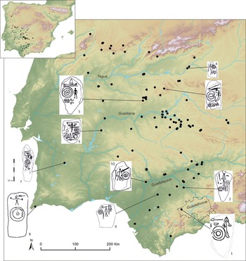
In this paper we explore these problems. Our approach is based on a particular case study, namely the Almargen stela, located in the Lands of Antequera (Málaga, Spain) (Fig. 1). This case study connects with our ongoing engagement in the study of the Dolmens of Antequera UNESCO World Heritage Site, which itself presents unparalleled complex biographies set in a mesh of multiple and highly dense landscape associations (for references in English, see Bradley & García-Sanjuán Reference Bradley, García-Sanjuán, Bickle, Cummings, Hofmann and Pollard2017; García-Sanjuán & Lozano-Rodríguez Reference García Sanjuán, Lozano Rodríguez, Laporte and Scarre2016).
Distribution of ‘warrior’ stelae in southwestern Iberia, with indication of the warrior stelae mentioned in the text and the region of Lands of Antequera. (1) Almargen (Málaga); (2) Écija 5/El Berraco (Sevilla); (3) Solana de Cabañas (Cáceres); (4) Las Herencias 1 (Toledo); (5) Zarza de Montánchez (Cáceres); (6) Monte Blanco/Olivenza (Badajoz); (7) Ervidel 2 (Beja); (8) Figueira (Algarve); (9) Cuatro Casas/Carmona (Sevilla); (10) Burguillos (Sevilla). (Image: Marta Díaz-Guardamino.)

Exploring emerging themes: ‘persistent places’, ‘place-making’ and ‘glocalization’
Almargen provides a unique case-study to explore further the notions of ‘persistent place’, ‘place-making’ and ‘glocalization’ in connection to prehistoric stelae. The concept of ‘persistent places’ is commonly applied to interpret patterns of accumulation of remains of activities (mainly lithic scatters) associated with Mesolithic societies (e.g. Barton et al. Reference Barton, Berridge, Walker and Bevins1995), but the model is equally applicable to the accumulation of remains produced in later periods. Persistent places may be associated with specific landscape features that attract human activity, such as heads of river drainage systems, fords, water springs, swamps, rocky outcrops, but also in relation to the exploitation of specific resources (ores, salt, pastures), or human-made features such as stone settings—including megalithic monuments—rock art and possibly hoards. Due to their durability, visibility, or to the memories and/or oral traditions associated with them, such features can attract long-term episodic use, but also permanent settlement, crafting the long-term histories of places of special significance (Bradley Reference Bradley2000, 155–8).
The relevance of place and placemaking in the forging of political landscapes or territories has been underscored in the context of early complex societies (e.g. Smith Reference Smith2003, 12). Bradley (Reference Bradley2000) also highlights the active role of places in the production of socially meaningful landscapes in the context of late prehistoric Europe. There, some places contributed to the (re)creation of long-term memories (and identities) and were subject of political manipulation (Bradley Reference Bradley2000, 155–9; 2002, 141–8). The implications of this for the study of Iberian LBA connectivity are clear: it is imperative to embrace the multi-temporality of place and gain understanding of the mediation of collective memory and persistent places in the making of LBA political landscapes and connectivity networks. In this context, the biographical approach (Gosden & Marshall Reference Gosden and Marshall1999; Kopytoff Reference Kopytoff and Appadurai1986) has shown great potential for addressing the social and historical dimensions of prehistoric stone monuments (García-Sanjuán & Díaz-Guardamino Reference García-Sanjuán, Díaz-Guardamino, Díaz-Guardamino, García-Sanjuán and Wheatley2015). In our research on stelae, this concept includes the chaîne opératoire (Leroi-Gourhan Reference Leroi-Gourhan1943) involved in their production, understood as the identification of the sequence of actions employed, from obtaining the raw material, to manufacture, primary and secondary ‘uses’ and ulterior deposition. Considering the durability and landscape dimension of these monuments, the various natural and anthropogenic post-depositional processes (including their eventual reuse/transformation, the effects of erosion or agricultural activities) that have contributed to their present state are also considered.
Finally, this paper further explores the interpretative potential of ‘warrior’ stelae by looking at a widely overlooked problem: their multiscale connections. The recent critique of core-periphery models and post-colonial theory in archaeology has derived in the adoption of globalization theory (e.g. Hodos Reference Hodos2016; Maran Reference Maran, Wilkinson, Sherratt, Bennet and Sherratt2011; Vandkilde Reference Vandkilde2016; Versluys Reference Versluys2014). Globalization theory has a global (i.e. related to situated known worlds) focus on connectivity at multiple scales (global, regional, local) simultaneously. The emphasis is on local participation in wider (messy) networks, on the continuous entangled flow of things, ideas and people. Maran (Reference Maran, Wilkinson, Sherratt, Bennet and Sherratt2011) adopted the perspective of ‘glocalization’ (Roudometof Reference Roudometof2016), which seeks to give due attention to the co-presence and co-constitution of the global and the local.
A ‘glocalization’ point of view is well suited to untangle the multiscale connections of ‘warrior’ stelae. As iconographic monuments with long-distance connections but also strong ‘local’ idiosyncrasies, they are key in processes of place-making. Through persistence, such places can engage in supra-local and even ‘global’ dynamics, revealing complex relationships between local practices and global processes. Previous approaches to Iberian ‘warrior’ stelae have failed to build bottom-up, theoretically informed and empirically sound approaches to their simultaneously local and supra-local nature. Research informed by globalization theory has focused primarily on material culture, but, as Roudometof (Reference Roudometof2016) has highlighted, geography (i.e. space) is perhaps the most relevant field to connectivity (and glocality). Yet the engagement with landscape in archaeology through the lens of globalization has been limited, particularly in Europe and the Mediterranean (e.g. see works in Hodos Reference Hodos2016). Large maps are drawn (e.g. Vandkilde Reference Vandkilde2016) and it is difficult to envision how the local and the regional mediated long-distance connectivity. In order to understand the global, we need to embrace the local and examine how it related to the global.
While ‘persistence’, ‘place-making’ and ‘glocalization’ are key concepts that define our theoretical priorities for an expanded research of prehistoric stelae, we remain as preoccupied as ever for the empirical grounding of our research. Thus, here we first present the results of a new analysis of the materiality of the Almargen warrior stela, which was conducted within a chaîne opératoire/biographical approach. We use petrography to characterize and determine the provenance of the stone, assess whether the stela had been found in loco and, if so, analyse the relationship of the monument with its surrounding landscape. We also deploy a range of digital technologies: Digital Image Analysis (DIA), including Principal Components Analysis (PCA) and HSI contrast-stretching techniques (Rogerio-Candelera Reference Rogerio-Candelera2015), Reflectance Transformation Imaging (RTI)Footnote 1 (Díaz-Guardamino et al. Reference Díaz-Guardamino, García-Sanjuán, Wheatley and Rodríguez2015; Mudge et al. Reference Mudge, Schroer, Noble, Matthews, Rusinkiewicz, Toler-Franklin, McDonald and Veth2012), and high-resolution Structure from Motion (SfM) photogrammetry (Table 1) (Green et al. Reference Green, Bevan and Shapland2014), as well as Field Emission Scanning Electron Microscope (FESEM) to produce a robust record of the stela. This is of the greatest importance in order to identify and analyse surface marks linked to the shaping of the block, (re)carving of motifs, as well as other marks linked to post-depositional processes, outline their sequence, and assess the application of possible surface treatments (i.e. pigments). This is followed by a comparative study of its iconography, not just from a formal point of view, but also from a technological one. This allows us to make inferences about the engagement of the communities involved in the making of this particular monument in broader networks of connections involving other regions of Iberia and beyond.
Control data for the 3D modelling of the stela of Almargen. See also 3D model at <https://skfb.ly/6MLuE>.

Secondly, we present the results of a fresh analysis of the context and landscape this stela was part of, including new data on metalwork found in the locality, as well as results from post-excavation analysis of the nearby site of Las Madrigueras, which up until now remained completely unpublished. Finally, we discuss how Almargen can be seen as a persistent place with connections at multiple scales, local (Lands of Antequera), regional (southwestern Iberia) and beyond, and how this relates to its geo-strategic location.
In summary, we adopt a theoretically informed, multidisciplinary bottom-up approach, as we believe that the combined analysis of the materiality and iconography of the stela (i.e. as material culture) and its context has the potential to push ahead the research agenda of prehistoric monumental sculpture. In so doing, we suggest that local practices and ‘know-how’ involved in the production and use of stelae were linked to persistent places deeply rooted in collective memories that played major roles in the crafting of territories and connectivity at multiple scales.
The Almargen stela: a local manufacture with multi-scale connections
Materiality
The stela of Almargen was the first ‘warrior’ stela found in Málaga, a province predominantly inside the Mediterranean hydrological domain, widely considered beyond the sphere of distribution of these stelae. In line with traditional approaches focused on the iconographic traits of ‘warrior’ stelae, the Almargen stela was first studied within a descriptive and essentially ‘typological’ framework that basically looked at the motifs and their possible chronology (Villaseca Reference Villaseca1993a). Since then, the number of known ‘warrior’ stelae in Iberia has doubled, while in Andalusia their number has risen from 17 to 40 examples. New discoveries have extended the geographical distribution of these monuments and diversified their iconographic parameters, in some cases providing valuable contextual data.
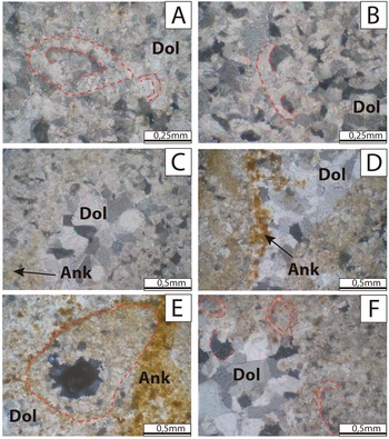
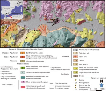
Our analysis confirms that the Almargen stela was found in loco, that it was locally made with local ‘know-how’, with reference to object-categories that had broad circulation and to emerging graphic conventions that were shared among distant communities (indicative of connectivity at multiple scales). Petrographic thin-section analysis reveals matching results between the stela and the lithology of a neighbouring hill, where numerous outcrops, loose slabs and evidence of quarrying activities of unknown date are found (Figs. 2 & 3).
Thin-section microphotographs taken under crossed nicols. (A–D) Almargen stela; (E–F) possible quarry. Dol = dolomite; Ank = Ankerite. (Image: José Antonio Lozano-Rodríguez.)

Detailed geological map of the area of Almargen. (Image: José Antonio Lozano-Rodríguez.)

The stela was carved in dark dolomite stone, part of both the Siles and the Cehegín formations. The two rocks (that of the stelae and that of the outcrop) contain iron carbonate (Ankerite) and present the same microfossils of Triassic-age foraminifera of the genus Triadodiscus. Its type species is Trocholina (Paratrocholina) eomesozoicus.
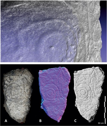
The preserved contour of the stela, which appears to be mostly original, has a roughly triangular shape (Fig. 4; see also 3D model at <https://skfb.ly/6MLuE>). The right-hand sideFootnote 2 has a rectilinear outline and shows some possible pick-marks of its primary shaping. The left contour shows large flakes produced by the fracture of the slab after the production of the stela (affecting the outline of the shield and the spear).
Digital recordings of the obverse of the stela of Almargen. Top: detail of the resolution of the 3D mesh created through SfM photogrammetry. Bottom: (A) Conventional photograph; (B) Normal map produced from RTI datasets; (C) Shading Grey Descriptor Radiance Scaling (Meshlab) applied to 3D model. See also 3D model at <https://skfb.ly/6MLuE> and RTI files at <https://doi.org/doi:10.15128/r2dv13zt222> . (Image: Marta Díaz-Guardamino.)

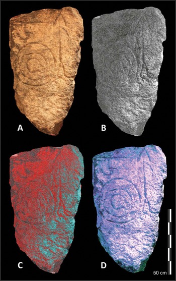
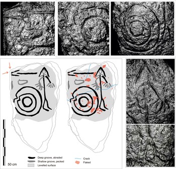
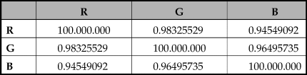
DIA did not suggest the presence of pigments on the decorated surface of the stela (Fig. 5, Table 2) and the FESEM images do not show anything related to further intentional surface treatment, although surface alterations linked to air pollution were detected. Detailed RTI examination (Fig. 6) confirmed that the decorated surface of the stela is considerably altered, also likely due to weathering, which may have been exacerbated by the properties of the material. The preparation of the slab included the careful levelling of the surface, achieving an almost perfectly flat surface (see <https://skfb.ly/6MLuE>). The marks detected via RTI include hammering or chiselling in the lower section. The middle and upper parts show a finer work of levelling, with marks of abrasion and pecking in different parts of the surface.
Digital Image Analysis. (A) Conventional RGB image of the stela; (B) 3rd principal component band of image A; (C) False colour image from PCA bands (combination 233); (D) HSI ECS treatment of one of the images of the stela. (Image: Miguel Ángel Rogerio-Candelera.)

(Bottom left) Interpretative synthesis of the features identified on the obverse of the stela of Almargen generated from information provided by RTI/PTM and 3D model visualization. Left: features produced through the shaping and carving of the slab in an initial phase with indication of the sides fractured at a later stage; Right: previous elements with the addition of flakes and fractures produced more recently. (Top and right) Details of the grooves making up different motifs and of marks produced of abrasion in the upper part of the shield (RTI snapshots produced with the ‘Specular Enhancement’ filter). See also RTI files at <https://doi.org/doi:10.15128/r2dv13zt222>. (Image: Marta Díaz-Guardamino.)

Correlation matrix of the pixel values of the bands of one of the images of the stela of Almargen.

The combined analysis of the RTI files and the 3D model permitted correction of some details of earlier interpretations, identification of previously undetected elements (e.g. differentiating between original preserved outlines and more recent chips) and determination of the carving techniques used and possible traces of re-carving, suggesting a sequence of execution. The motifs detected comprise a V-notched shield, a spear, a human figure with possible helmet, a fibula with a small appendix, and other marks of likely anthropogenic nature in the lower section of the slab (Fig. 6).
From a technical point of view, the most complex motif is the human figure. The conical motif (perhaps a helmet) closes at the height of the neck. The engraving of the cone has more depth and a smoother surface, the result of abrasion, than the groove closing at the base, which is shallower, more irregular, and it overlays (cuts) the groove representing the neck. Inside the triangle we only detect a very faint circular motif, somewhat striking as human figures on warrior stelae tend to have a well-defined head. Most of the grooves outlining the body of the human figure have a U-section and smooth surface. Nonetheless, the left arm, hands, legs and feet have shallower, not so well-defined grooves and/or rougher surfaces. In the case of the legs it is possible that the rough surface is the result of post-depositional surface alteration. The surface of the groove of the left arm does not appear to be altered; therefore this element might not have received the same finish as the right arm.
The carving technique is the same for nearly all motifs: a wide (c. 10 mm or 10–15 mm in the case of the shield) and deep, open groove (mostly U-section) made by pecking with a smooth surface abrasion finish (Fig. 6). However, variations in the depth and texture of the grooves have been detected, both in the delineation of a single motif (e.g. conical motif) and in the complete outline of individual features (e.g. the hands). This variation could be associated with various factors: (i) the heterogeneous structure of the stone (directly impacting on the engraving work); (ii) the skill of the carver/s and their knowledge of the raw material; (iii) the intentional emphasis of certain features of the represented figures (e.g. conical element) in the primary phase of engraving or at later stages (re-carving); (iv) and/or subsequent erosion that has deteriorated the surface of the grooves. In addition, a carving sequence has been inferred from the few superimpositions detected and the position of the different motifs on the stone canvas. Due to their position, possibly central prior to the fragmentation of the slab's side, the shield and the spear are the articulating elements of the composition. The human figure was likely engraved after the shield, as the morphology of the body, particularly the legs, is adapted to the shield's outline. The human figure's torso and lower limbs were engraved before the left arm and the horizontal line that closes the conical headpiece, as the groove of these two motifs cuts (overlays) that of the torso/neck. The conical motif over the warrior's head was engraved prior to its horizontal closing line, possibly at the same time as the figure's torso and legs. Naturally, we can only infer the sequential order in which the motifs were carved, but it is not possible to establish the time elapsed between them.
Sometime after the carving phase the slab was broken on its left side and the upper left edge (Fig. 6), affecting a section of the spearhead, part of the outline of the shield's outer rim, and most of an unidentified motif positioned between the two. The stone also suffered cracks or breaks in recent times. A series of chip marks found only in the middle and upper sections of the slab, over the engravings, were possibly the results of weathering and deliberate removal. These may have occurred in a phase when the decorated part of the surface was exposed while the lower third was not, perhaps during a period of early use when the stela was erected in the landscape.
Iconography
Iconographic analysis allows us to view the Almargen stela within broader networks of connections. The motif categories depicted on stelae reflect a selection of the artefact categories that became known to, were manufactured by and/or circulated among Iberian communities through their engagement in connections with the broader Atlantic and Mediterranean. They were selected because of their currency and translated into genuinely local/regional Iberian expressions to convey ideas that were already known to western Iberian communities (e.g. the warrior archetype, as expressed in earlier stelae and statue-menhir traditions: Díaz-Guardamino Reference Díaz-Guardamino2010).
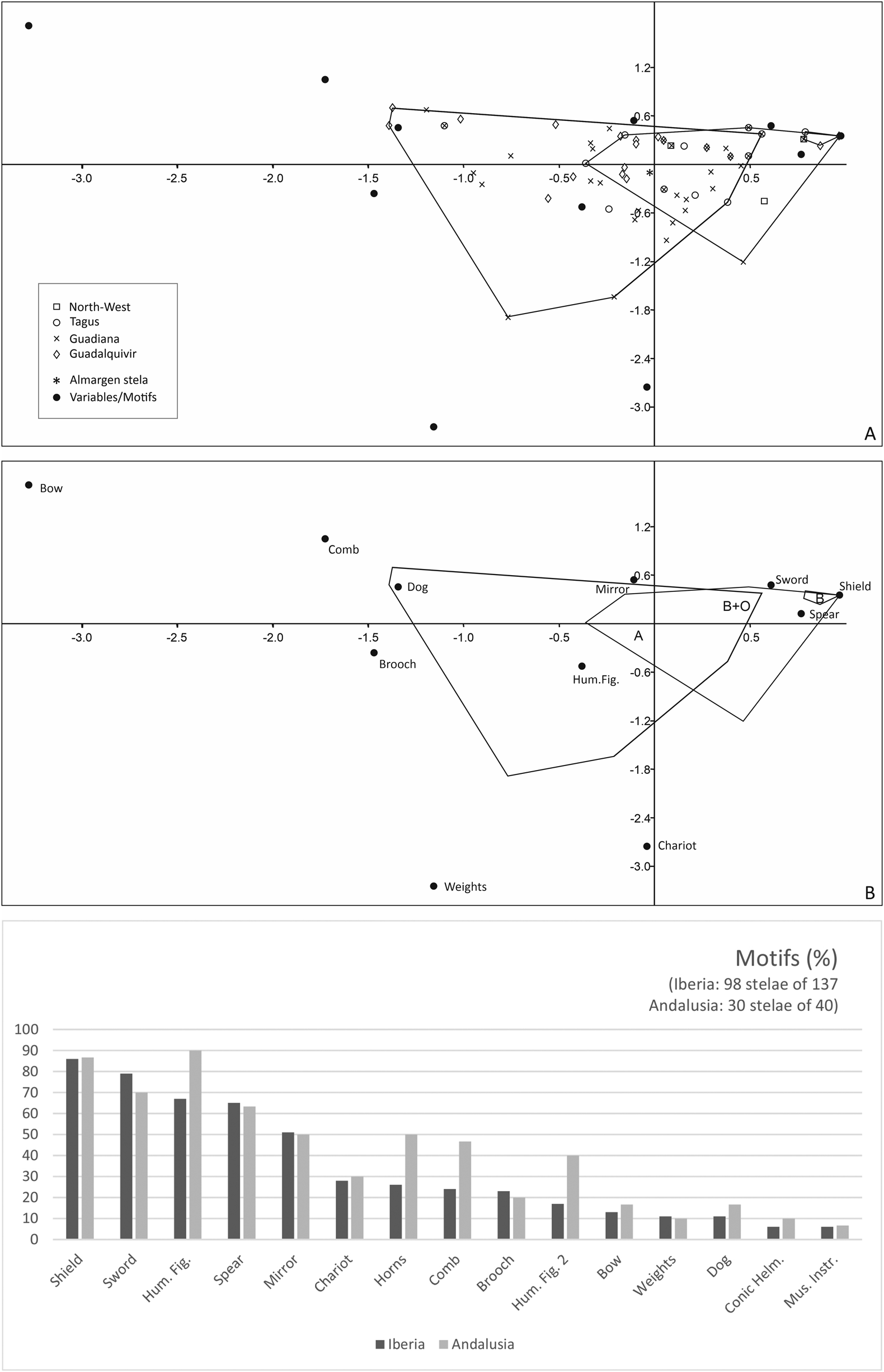
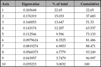
The Almargen stela includes three of the most common motifs in ‘warrior’ stelae: a shield, a spear and a human figure (Fig. 7, bottom). A frequent starting point when analysing the formal variability of stelae is the covariation of iconographic motifs, which informs us about the object categories that were chosen to be represented and their combination. Early quantitative studies of stelae iconography (Barceló Reference Barceló1989, 381, 394–5; Galán Reference Galán1993, 43–8) were based on a limited number of cases (57 and 52 complete or well-preserved stelae). Today, we have 95 well-preserved stelae. We analysed this larger sample with Correspondence Analysis (CA) using 11 variablesFootnote 3 (motifs) in order to explore iconographic variability (covariation of motifs) (Fig. 7, top and centre). CA produces two dimensions which account for only 37.7 per cent of the total variance (Table 3), a percentage which increases to 51 per cent if we include the third dimension. Although this percentage of variation is low, and the results cannot be taken at face value, there appear to be some interesting elements for discussion. The distribution of cases and variables (Fig. 7, top) seem to be indicating a gradual increase in the ‘iconographic vocabulary’ available over time. This would be in line with the generally accepted idea that these stelae represent a selection of object categories which circulated (as actual objects or ideas) via changing networks of social interaction. This matches currently accepted chronologies for the presence (in Iberia) and broader circulation of each of the artefacts (or knowledge of them) (Díaz-Guardamino Reference Díaz-Guardamino and Jiménez Ávila2012).
(Top and centre) Correspondence Analysis dispersion diagram: (A) Cases (well-preserved stelae codified after the main region where they were found) and variables (● motifs); (B) Variables (● motifs), with indication of the groups’ convex hulls (‘types’ B, B+O, A). (Bottom) Presence of each motif in well-preserved stelae (percentage) in Iberia compared to Andalusia. (Image: Marta Díaz-Guardamino.)

Summary of the Correspondence Analysis.

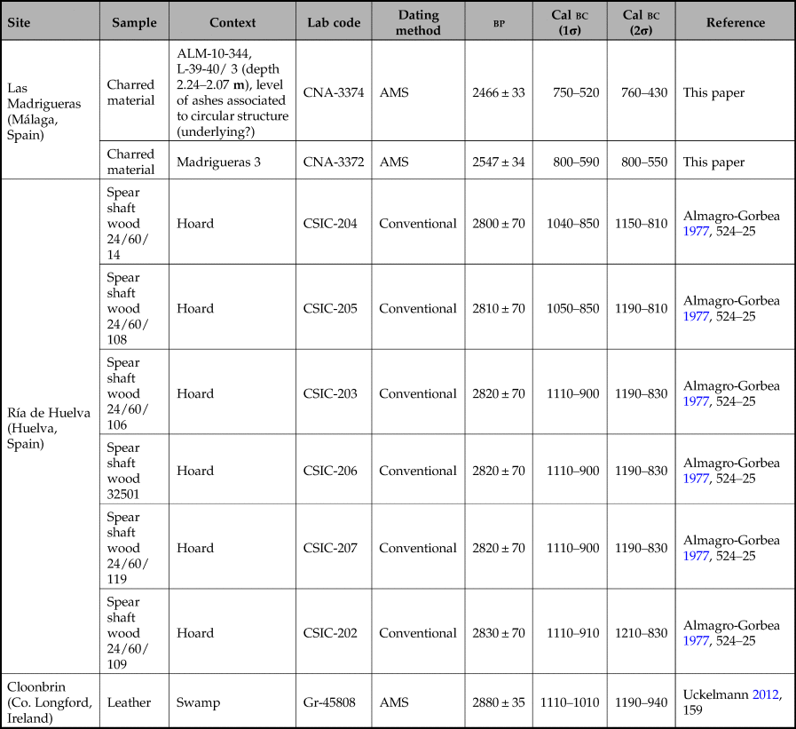
These chronologies are based on the radiocarbon dating (direct or by association) of artefacts that circulated or could have been known in western Iberia during the late second and early first millennia cal bc, such as spears, swords, conical helmets, fibulae or V-notched shields. These are directly relevant for the evaluation of the Almargen stela within a wider framework of connections, patterns of exchange and weapon deposition developed in this region during the twelfth and eleventh centuries bc. The human figure has a conical motif above the head, like those documented on the stelae of Setefilla and Ategua (Díaz-Guardamino et al. Reference Díaz-Guardamino, García-Sanjuán, Wheatley and Rodríguez2015). The interpretation of this motif as a conical helmet (Villaseca Reference Villaseca1993a, 219–20) is risky, given its simplicity. Conical motifs clearly depicting conical helmets are scarce. These include the stelae of Santa Ana de Trujillo and Zarza de Montánchez (Cáceres) (Díaz-Guardamino Reference Díaz-Guardamino2010, catalogue, 339, 355), as well as the unpublished example of Telhado (Fundão, Castelo Branco, Portugal). These stelae bear representations of helmets similar to the one found in the Ría de Huelva ‘hoard’, radiocarbon-dated to the eleventh and tenth centuries bc (68 per cent probability) (Table 4).
Radiocarbon dates mentioned in the text. Calibration conducted with OxCal v4.3.2, with the atmospheric curve IntCal13 (Reimer et al. Reference Reimer, Bard and Bayliss2013).

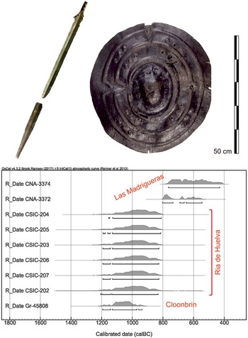
While the iconography of the Almargen stela presents the ‘canonical’ elements that set it as a ‘warrior’ stela in line with other several dozen monuments like it known in western Iberia (always in Atlantic Iberia), the conical motif above the head of the ‘warrior’ and the absence of a sword (one of the artefacts most frequently depicted in these monuments) endows it with a clear idiosyncrasy, a topic we will return to below. Paradoxically, the involvement of the Almargen communities in broader connections at this time is further suggested by the ‘Huelva type’ sword found barely 400 m from the find-spot of the stela (see below). Brandherm (Reference Brandherm2007) identified the sword as belonging to Series I, dated to the Willburton/Saint-Brieuc/Hío phase (c. 1130–1050 bc). Huelva-type swords are Iberian-styled productions (Brandherm Reference Brandherm2007; Rovira Reference Rovira and Brandherm2007), although some examples are also found in Britain and France. To this we can add the recent radiocarbon dating of the V-notched leather shield from Cloonbrin (Co. Longford, Ireland) (Uckelmann Reference Uckelmann2012, 72–3), with a morphology akin to those represented on numerous ‘warrior’ stelae, including that of Almargen (Fig. 8), dated to around the eleventh century bc (68 per cent probability) (Table 4).
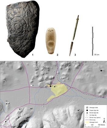
(Top) The Almargen Huelva-type sword and the leather shield from Cloonbrin (Co. Longford, Ireland). (Photographs: Marta Díaz-Guardamino and National Museum of Ireland, respectively.) (Bottom) Multiple plot of the probability distributions of the radiocarbon measurements mentioned in the text (see Table 4). (Generated with Cal v4.2.4).

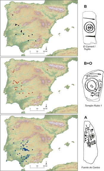
Current accepted dates for the presence or circulation in Iberia of the artefact categories depicted are also consistent with the chronological development proposed for the three major ‘warrior’ stelae groups distinguished by researchers (Díaz-Guardamino Reference Díaz-Guardamino and Jiménez Ávila2012, table 2). These are linked to changing connectivity flows between the western periphery of the Iberian Central Plateau, the Atlantic fringe and the southwest, but also further afield across Atlantic Europe and the Mediterranean (Díaz-Guardamino Reference Díaz-Guardamino2010, 327–411; Reference Díaz-Guardamino and Jiménez Ávila2012). The joint presence of a sword, shield and spear (type B, after Díaz-Guardamino Reference Díaz-Guardamino and Jiménez Ávila2012) appears to be the oldest, and is related to connectivity flows with the broader Atlantic. This basic panoply appears alongside other objects (e.g. fibula, mirror, comb, chariot), which were linked to Mediterranean connections, in type B+O. Type A would include varying numbers of those artefacts, along with one or more schematic human figures, whose presence has also been tentatively linked to connectivity with the Mediterranean—the stela of Almargen would belong to this group. These three major groups present slightly overlapping supra-regional distributions (Fig. 9). While all B, B+O and A seem to develop simultaneously from the twelfth to the tenth centuries bc, however, only A seems to have continued up until the beginning of the EIA, as is broadly reflected in the CA plot (Fig. 7, top).
Distribution of ‘warrior’ stelae per main ‘type’ in Iberia. (Image: Marta Díaz-Guardamino.)

Other dimensions of variability can also inform us about changing connectivity flows within the western fringe of the Iberian Central Plateau. There were stylistic conventions underlying the ways in which motifs were arranged on the stone canvas, or subtle stylistic choices in the ways motifs were represented. These formal conventions were crafted through connections across more or less extended network flows; these could be regional or inter-regional. In the case of Almargen, the engravings on the stela reproduce iconographic conventions which are found across various regions of the Iberian southwest (i.e. the Guadalquivir valley, south Portugal, or even further, more than 300 km away, in the middle Guadiana and the middle Tagus) (Fig. 1). For instance, the morphology of the human figure, with curved upper limbs, and the size and relative position of the shield in relation to the human (next to each other) appears on three stelae in the Guadalquivir valley (Burguillos, Écija 5/El Berraco and Cuatro Casas/Carmona) (Fig. 1). In the case of Burguillos, the shield and human figure have similar proportions to those on the stela of Almargen. Additionally, the horizontal position of the spear, along the upper edge of the decorated surface, is scarcely documented on type A stelae of the Guadalquivir valley (3 examples). However, its frequency increases in the middle Guadiana (9 examples), and one example is known in the Algarve, plus two in the middle Tagus. Three stelae in the Middle Tagus (Solana de Cabañas, Zarza de Montánchez, Las Herencias 1) and three in the Guadiana/south of Portugal (Figueira, Ervidel 2 and Monte Blanco/Olivenza) share common features with the stela of Almargen (Fig. 1): V-notched shields (5, possibly 6 examples), an oversized shield in parallel to the human figure (4), a representation of a fibula at shoulder/head height (4), oversized hands (3) and a conical helmet (1).
However, there are significant differences between the execution techniques of the carvings documented on the Almargen case and those of others, such as Solana de Cabañas or Ervidel 2. The motifs on the Almargen slab show much simpler outlines and more rugged grooves than those documented on the stela of Solana de Cabañas, for example. In the latter, motifs were neatly outlined, some of the motifs’ interiors being completely pecked with fine and dense pecking. In the stela of Solana pecked areas were not abraded, whereas large portions of the grooves depicting motifs on the Almargen stela were abraded. What the stela of Almargen shares with most of the other stelae belonging to this tradition is a carefully levelled surface, the finish, however, being much rougher—although this may be partly due to the poor preservation of the rock's surface.
These technological details are highly relevant, since even though the iconographic conventions can be interpreted as the result of the immersion of the communities of Almargen in broader connections, the stela presents clear idiosyncrasies in the way it was made, as also occurs in the cases of Setefilla and Almadén de la Plata 2 (Díaz-Guardamino et al. Reference Díaz-Guardamino, García-Sanjuán, Wheatley and Rodríguez2015). The style in which the same categories of motifs are depicted, as well as their technical properties and the carving sequences, differ notably between these monuments, a fact that is even more striking when we consider that all of them were documented in the Guadalquivir valley. This underlines the significance of their local dimension, in that their crafting was probably in the hands of local artisans who likely had limited experience in stelae making and/or implemented carving techniques known in local/regional rock-art traditions, as occurs in the middle Guadiana, for example (Domínguez & Aldecoa Reference Domínguez and Aldecoa2007; see also Díaz-Guardamino Reference Díaz-Guardamino, Back Danielsson and Jonesin press). This suggests that despite the use of a widely shared graphic ‘language’, there was no single way of making a ‘warrior’ stela. This has relevant implications when interpreting the social and ideological dimensions of these monuments. Importantly, petrographic analyses indicate that the slabs used to manufacture the stelae of Almadén de la Plata 2 (García-Sanjuán et al. Reference García-Sanjuán, Wheatley, Fábrega, Hernández and Polvorinos2006) and Almargen (see above) were locally sourced, further underlining that stelae making was a globally shared but locally interpreted practice.
Almargen: a persistent place of passage in a connected world
Unlike many other Iberian ‘warrior’ stelae, the exact location of the Almargen stela when it was discovered is known. Mr Francisco Morón, who discovered the stela in the early 1980s alongside Mr Francisco Hidalgo, accompanied us to the exact spot where the stela was found, located on a road heading eastward at the outskirts of Almargen (Fig. 11.1), which overlies a droveway. Along this stretch, northwards from the current road, there is a small hill on whose slope the stela was discovered. As mentioned before, there are numerous rocky outcrops on this hill, some of them showing evidence of quarrying, as well as pre- and proto-historic ceramic sherds. Petrographic analysis proves that the rock employed to make the stela was quarried from this hill (Fig. 3). South of the road, a wide plain stretches out dotted with wells (fresh water) which reveal the swampy past of this land. Indeed, the name ‘Almargen’ comes from the Arabic al-marj, which in Spanish means ‘swamp, meadow or pasture’ (Vernet Reference Vernet1960), although Asín (Reference Asín1940, 67) writes it with a j, ‘Almarjen’, treating it as a derivative of the plural of maryain, ‘the two meadows’. In any case, both meanings refer to the use of the town's land as pastures which, as the wells in the area show, must frequently have been flooded.
When Morón and Hidalgo found the stela, they overturned it to hide its engravings and covered it with stones, leaving it in its place. It was not until some years later that they moved it to municipal facilities for study by Villaseca. However, as Morón informed us, this was not the only stela that they found at this location as during those years, they discovered a second stela with similar engravings. They also left it in loco but unfortunately it disappeared and, for this reason, there is no record of it. There are reports concerning a further two stelae, also mentioned by Villaseca (Reference Villaseca and de la Casa Martínez1993b), found at the site of Lacipo (Casares), also in the province of Málaga, but unfortunately they were never studied and their present location is unknown.
Regardless of the specific details (important as they are), the stela of Almargen was set in a place of special significance endowed with great geo-strategic value. Almargen is a transit point between the two main hydrological and climatic regions of Iberia: the Atlantic and the Mediterranean. The stela was found almost exactly at the drainage divide between those two regions, the hydrological basin of the Guadalquivir river (through one of its main tributaries, the Corbones river), that runs towards the Atlantic further to the west, and the Guadalhorce river which, via its tributary the Guadalteba river, flows towards the Mediterranean in the south. Crucially, because of its position, Almargen is a gate place, or hinge, between two of the most culturally complex regions of Iberian later prehistory: the Lands of Antequera and the lower Guadalquivir valley (Fig. 1). In that capacity, since regional interaction became more frequent and intense in the Later Neolithic, Almargen held major potential to become a remarkable liminal place between two rather distinctive geographic domains and two culturally powerful regions.
Almargen's connecting role is underscored by a dense network of ancient roads and traditional droveways. A Roman road (XIb) coming from the Vía XI, which connected Antikaria (Antequera) with Acinipo (Ronda la Vieja), passes by Almargen (Fig. 11) (Gozalbes Reference Gozalbes1986, 201). In addition, no less than six droveways intersect in this locality. This highlights the relevance of Almargen as a communication point in Antiquity and the Middle Ages (Gozalbes Reference Gozalbes, Díaz López and Munhoz Buendía2002). Every bit of evidence suggests that the connecting role of Almargen in ancient and medieval times was also in play during later prehistory. We will give three examples of this.
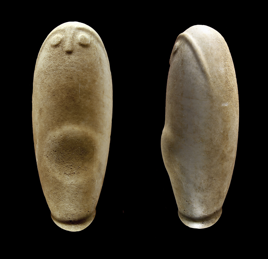
Although little is known about Almargen in the Late Neolithic and Chalcolithic periods, there is however, evidence suggesting that it may have been a prominent locus of activity in both periods. The most important of them is the so-called Almargen ‘idol’ (Fig. 10). This object, measuring 48 cm in height and weighing 22.2 kg, is made of marble and has an overall oval shape (Villaseca Reference Villaseca1993–94, 37). At what seems to be its upper end there are carefully carved eyebrows, eyes and nose in low relief, in the fashion typically known in Atlantic portable, megalithic and rock art (see e.g. the Folkton Drum 1, in Jones et al. Reference Jones, Cochrane, Carter, Dawson, Díaz-Guardamino, Kotoula and Minkin2015, or the decorated orthostat I21 of the Dolmen de Soto, in Bueno et al. Reference Bueno Ramírez, Linares Catela, de Balbín Behrmann and Barroso Bermejo2018, 317). A little further down, at the centre of this sculpture, there is a protruding hemisphere that makes the figure look like a pregnant woman, although no breasts are represented. At the bottom end there is a similar hemispherical enlargement, like a knob, which when the sculpture is turned upside down gives it a vague resemblance to a phallus. This object is not only very interesting because of its size and beautiful finish, but also because of its suggested hybrid nature in terms of fertility and reproduction. The idol was found during non-archaeologically controlled construction work in the Camino de Saucejo street, 200 m east of the ‘warrior’ stela's find-spot (Fig. 11.2) (Villaseca Reference Villaseca1993–94). Although, unfortunately, there is no further information about its context, the Almargen ‘idol’ is perhaps one of the most remarkable examples of portable (or semi-portable, considering its weight) imagery in the whole of Iberia and indeed western Europe, presenting a highly idiosyncratic combination of ‘fertility’ symbols more or less commonly found in Late Neolithic and Chalcolithic contexts. Given its exceptional characteristics and singularity, it is only fair to assume that this image was connected to an important sanctuary or sacred place in later prehistory, perhaps attracting visitors from further afield.Footnote 4
The Almargen ‘idol’ (height: 48 cm). (Image: Miguel Ángel Blanco de la Rubia.)

Pre- and proto-historic sites found in the municipalities of Almargen (centre) and Cañete La Real (west) and their relationship to Roman/traditional droveways. (1) ‘Warrior’ stela find-spot; (2) Almargen ‘idol’ find-spot; (3) Huelva-type sword find-spot; (4) Cerrillo de las Madrigueras; (5) Haza del Almirón; (6) Arroyo La Rana; (7) Cerro de Las Rosas; (8) Ladera Majavea; (9) Plataforma las Ventanas; (10) Espolón de las Ventanas; (11) Cueva Arroyo Dehesa; (12) Herriza Arroyo Fuentezuela. (Image: Marta Díaz-Guardamino.)

A second discovery highlighting the special significance of Almargen as a nodal place is a Huelva-type sword broken in two pieces that was found by a resident, Mr Manuel Lozano, during non-archaeologically controlled construction work 200 m east of the ‘idol’ (400 m east of the stela)Footnote 5 (Fig. 11.3). Only the larger portion of the sword, whose blade fracture was sharpened, was published by Villaseca (Reference Villaseca1993a) and Brandherm (Reference Brandherm2007, 59, plate 8), since they were not aware of the existence of the terminal part of the blade. This fragment, which seems to be intact, was kept in the Almargen Town Hall and went unnoticed until 2009, when it became part of the exhibition in the interpretation centre, along with the stela studied here (Fig. 8, top). A thorough examination of the sword through suitable analytical methods will be carried out soon, but a naked-eye inspection of the fracture of the terminal fragment suggests that the sword may have been intentionally broken before its deposition. This occurrence is well documented both in Iberia and in other European regions, and has been associated with the public ‘killing’ of metalwork, particularly swords, carried out at ceremonial feasts or ‘potlatches’ during the LBA (Bradley Reference Bradley1990, 36, 103). The tang and blade of this sword strongly resemble some of the swords considered most ‘archaic’ in the Ría de Huelva hoard. Brandherm classified it as a Huelva type sword, Series I; the author dates this group to the Willburton/Saint-Brieuc/Hío phase (c. 1130–1050 bc) (Brandherm Reference Brandherm2007, 16, 59, fig. 6, plate 70). The terminal part of the blade, recently documented by us during our visit to the interpretation centre, confirms this classification.
The deposition of weapons during the LBA, particularly in aquatic environments, is a well-known phenomenon throughout Europe, and Iberia is no exception. These deposits have been interpreted as offerings associated with the public display and intentional destruction of weapons, which would be linked to rites of passage conducted within the context of ceremonial gatherings (e.g. funerals, banquets) (Bradley Reference Bradley1990, ch. 3; Reference Bradley2016; Ruiz-Gálvez Reference Ruiz-Gálvez and Ruiz-Gálvez1995). The sword of Almargen was discovered by chance and its find-spot was not systematically investigated. Therefore, it is not possible to rule out that it formed part of a more complex hoard comprising other objects, or even faunal remains, as is the case in some better-known deposits from northwest Europe (Bradley Reference Bradley2016, 58–71).Footnote 6 However, isolated swords have been found both in terrestrial and aquatic environments. The case of Almargen is of significance, since it is close to a swampy environment.
Close to the location where the idol, the sword and the stela were found, 800 m to the west, there is an elevation known as Las Madrigueras hill (Fig. 11.4) (Villaseca Reference Villaseca1990, 509; Reference Villaseca1993a, 218). In 1992, a three-week archaeological excavation led by Villaseca was undertaken in Las Madrigueras. The aim was to explore the context of the stela, establishing the character of this remarkable elevation, 120–170 m in diameter, where large quantities of surface archaeological material had been identified. The excavation, which to this date remains unpublished, covered 20 sq. m. It revealed remains of various features, interpreted as domestic structures by the excavator, but neither apparent funerary structures nor human remains were identified.
A considerable amount of ceramic material was recovered. The sample analysed for this study (244 fragments) includes items that on the basis of their morphology and stylistic properties can be roughly dated to the second half of the eighth century bc,Footnote 7 within the Early Iron Age (also known as the ‘Orientalizing’ period). Among the wheel-thrown items (N = 136), there is a significant number of vessels used for storage (pithoi, urns with flared necks and Cruz del Negro urns) and service (pots, plates, bowls), and some amphorae (T.10.1.2.1 type: see Ramón Reference Ramón1995, 230ff, fig. 109). Within the assemblage of hand-thrown pottery (N = 100), the largest group is that of kitchenware (27) with pots decorated with fingertip and nail impressions, characteristic around the eighth century bc (Ruiz Reference Ruiz1995, 278, figs. 25, 26). Within the ‘service’ crockery group, carinated pots and hemispherical bowls predominate, particularly the former, although no decorated or painted examples with geometric motifs or burnished lattice have been recorded. The profiles of these pots correspond to type A.I. (carinated pots) after Ruiz's typology, who dates them to the LBA, from the tenth century bc onwards; these would belong to phase I, the earliest chronology prior to contact with Phoenician colonists (Ruiz Reference Ruiz1995, 266ff, figs. 2–8), although their presence alongside more recent types in Las Madrigueras suggests they might be residual elements. Finally, the presence of ‘strainers’, which have been associated with highly disparate functions such as silver cupellation or cheese making, should be highlighted.
In short, the ceramic sample studied is representative of a wide range of domestic activities carried out at the site from around the tenth century bc onwards. This chronology appears to be largely consistent with the two radiocarbon measurements obtained from samples of unspecified charred material, which span between the mid eighth and the early sixth centuries cal bc (68 per cent) (Table 4).
The excavations also yielded polished and chipped stone tools (i.e. flint), as well as a wealth of faunal remains. From the sample of faunal remains studied as part of this research (fragments = 868), only 226 specimens (26.04 per cent) could be identified anatomically and zoologically due to the high degree of fragmentation. The results indicate that in terms of the biomass, the staple diet of the human group that occupied this dwelling was based on cattle (MNI = 4), sheep and goat (NMI = 8) and pig (MNI = 4). Wildlife is only represented in small numbers by two species (deer and rabbit). There seem to be equal numbers of sheep and goats, despite difficulties in their identification. The majority of these domestic animals were sacrificed before maturing. This implies a management of the herds and flocks which generically involved slaughtering the majority of the males at an early age as a source of meat, while keeping the females for breeding and for secondary products (especially cows, sheep and goats). In the case of pigs, the exploitation pattern was focused on meat use, although it was the third most important within the represented livestock populations. The scarce game within the faunal assemblage indicates limited complementary hunting activity.
In addition to the ‘idol’, warrior stela and sword find-spots and Las Madrigueras, close to each other in space and time, there is a series of sites in Almargen with remains of prehistoric activity. Among these, Haza del Almirón, comprising at least 15 artificial caves with vertical shafts in which materials attributed to the Chalcolithic, LBA and IA, among others, were recovered, is worth mentioning (Fig. 11.5) (Villaseca Reference Villaseca1993a, 218; Reference Villaseca1993–94, 509).
All these elements underline the importance of Almargen as a persistent place with multiscale connections. The density of special finds, such as the ‘idol’, the ‘warrior’ stela or the Huelva-type sword reveals the density of uses and materialities in a locus that fits in barely 2.5 sq. km.
Persistent places, connectivity and the making of political landscapes
In the preceding pages we have described evidence suggesting that Almargen was a place of outstanding territorial significance. This significance was rooted in its geographical location, as a ‘gate’ between the two main physical domains of the Iberian Peninsula, the Mediterranean (Guadalhorce river) and the Atlantic (Guadalquivir river), a true ‘hinge’ connecting two regions that since the Late Neolithic had witnessed phenomenal cultural and social dynamics: the Lands of Antequera (Guadalhorce basin) and the lower Guadalquivir valley. Place-making and the crafting of social landscapes through remarkable stone monumentality was paramount in both regions, presided over respectively by the Antequera megalithic landscape and the Valencina mega-site.
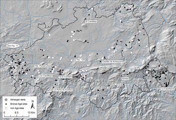
By the last third of the second millennium bc, large megaliths and ditched enclosures were no longer being built in Iberia, although the ancient ones from the Late Neolithic or Copper Age were very often re-visited and used. Monumentality had shifted towards new practices and forms, and ‘warrior’ stelae became powerful vehicles in the making of political landscapes—which were dominated by a strong new currency: metals. At that time, the Lands of Antequera experienced an intensive process of territorialization. Old settlements such as Aratispi, La Capellanía and El Castillejo (which were abandoned at the end of the third millennium) witnessed renewed activity, while new settlements such as Los Castillejos, Castillo de Antequera, Site 129 and Huerta de Peñarrubias were established (Fig. 12). Although the data available on land occupation strategies at the end of the second and beginning of the first millennia bc are limited, the communities living in the region experienced increasing competition and hierarchization, possibly accompanied by more rigid territorialization patterns. This occurred within a framework in which communities intensified their long-distance contacts and probably also competition for strategic resources. In this context, metal ores would have played an important role. On the one hand, sites such as La Peña de Ardales and El Cerrajón, located in Ardales, or El Castillón (Campillos), would have played an important role in the articulation of connectivity and mobility between the Lands of Antequera and the Mediterranean coast (Figs. 1 & 12) (Martín Reference Martín1994, 15). It seems too much of a coincidence that the exceptional stela of Almargen (and possibly the other stela currently missing), with its ‘warrior’ symbols, or the Huelva-type sword, were found precisely on a location marking the transit between the Guadalquivir (Atlantic) and Guadalhorce (Mediterranean) basins, a place of strategic value which acted as ‘hinge’ between the coast of Málaga, the Lands of Antequera and the lower Guadalquivir valley. The process of increasing territorialisation and delineation of boundaries in the LBA across the Lands of Antequera is consistent with the use of stelae and hoards as landmarks. During this period, other Iberian regions where ‘warrior’ stelae are found, such as the Middle Guadalquivir valley, the Middle Guadiana, the Middle Tagus and the Beira Interior, closely connected to areas rich in metal ores (i.e. copper, tin and/or gold), witnessed comparable processes of territorialization and became embedded in networks of long-distance connections (e.g. Armada et al. Reference Armada, Rafel, Montero, Celestino, Rafel and Armada2008; Díaz-Guardamino Reference Díaz-Guardamino2010, 368–89; Ling et al. Reference Ling, Stos-Gale, Grandin, Billström, Hjärthner-Holdar and Persson2014; Melheim et al. Reference Melheim, Grandin and Persson2018; Montero et al. Reference Montero, Hunt, Santos, Celis, Delibes, Fernández and Grau2007; Murillo Reference Murillo1994; Murillo-Barroso & Martinón-Torres Reference Murillo-Barroso and Martinón-Torres2012; Murillo-Barroso et al. Reference Murillo-Barroso, Peñalver, Bueno, Barroso, de Balbín and Martinón-Torres2018; Pavón Reference Pavón1998; Vilaça Reference Vilaça1995; Reference Vilaça, Celestino, Rafel and Armada2008; Vilaça et al. Reference Vilaça, Beck and Stout2002).
Distribution of Bronze Age and Iron Age sites in the Lands of Antequera with indication of the area of Almargen (sites mentioned in the text are labelled). (Image: Marta Díaz-Guardamino.)

The nodal significance of Almargen increased after the foundation of the first Phoenician settlements on the Málaga coast in the ninth century bc. From then on, the Corbones river valley, which connects the Lands of Antequera to the plains of Carmona in the lower Guadalquivir valley (in Seville), would be the main land route between the sphere of Phoenician influence on the coast of Málaga and the ‘Orientalizing’ sites in the Seville province (e.g. Setefilla, Cruz del Negro, Carmona, El Carambolo) (Fig. 12). In this context it is significant that the Almargen stela is the only one of its type to have been found within the Mediterranean hydrological basin,Footnote 8 and that this stela is closely associated with Las Madrigueras, a very active EIA settlement in which some of the innovations linked to the Phoenician presence in Iberia (i.e. wheel-thrown pottery) are well represented.
During the LBA and EIA the strategic relevance of Almargen in southern Iberia is further underlined by increased connectivity brought about through interaction with a variety of ‘external’ agents (such as Myceneans, Sardinians, Phoenicians and others). Both the find-spot of the stela and the sword and Las Madrigueras are found along traditional droveways, one of which unfolds along a Roman way (Fig. 11). The spatial convergence of ancient pathways, stela(e), and the deposit of a ‘killed’ sword reiterates the role of this area as a significant liminal place and transit hub. The active role of stelae (and other monuments such as menhirs, megaliths, and statues) and hoards as landmarks, both at a sacred and a profane level, as well as their close association with passage ways, has been sufficiently demonstrated (Galán Reference Galán1993; Murrieta-Flores et al. Reference Murrieta-Flores, Wheatley, García-Sanjuán, Mayoral and Celestino2011; Ruiz-Gálvez Reference Ruiz-Gálvez and Ruiz-Gálvez1995; Ruiz-Gálvez & Galán Reference Ruiz-Gálvez and Galán1991). Warrior stelae have been interpreted as commemorative funerary monuments used strategically by social elites in rural environments to reassert their control of the land, its exploitation and transit (Díaz-Guardamino Reference Díaz-Guardamino2010; Enríquez Reference Enríquez2006). The Almargen stela upholds each one of those patterns: the monument is spatially linked to an area rich in pastures and water resources (including salt), all associated with livestock exploitation, and to a place of high connectivity and strategic significance in the territorial fabric of southern Iberia during the LBA and EIA.
The commemorative role and mortuary dimension of ‘warrior’ stelae are fundamental for their understanding (e.g. Díaz-Guardamino Reference Díaz-Guardamino2010; Reference Díaz-Guardamino2014; García-Sanjuán et al. Reference García-Sanjuán, Wheatley, Fábrega, Hernández and Polvorinos2006), and these cannot be dissociated from their role as landmarks. These monuments were polyvalent and performed diverse roles depending on the social context in which they were active (see also Enríquez Reference Enríquez2006; Harrison Reference Harrison2004). Sometimes the spatial overlapping of funerary and commemorative monuments has proved to be a clear indicator of the persistence of some places—and monuments—in the collective memory of diverse communities over centuries and even millennia, as the necropolis of Setefilla (Seville) attests (Aubet Reference Aubet1997; Díaz-Guardamino et al. Reference Díaz-Guardamino, García-Sanjuán, Wheatley and Rodríguez2015; Reference Díaz-Guardamino, García-Sanjuán and Wheatley2019). The available evidence (including especially the ‘idol’) suggest that, by the end of the second millennium bc, Almargen had already been a persistent locus of strategic importance for a long time.
It is unusual for the metal weaponry attributed to this period and stelae to appear in the same region. This further underlines the importance of Almargen. Stelae and metal weapons represented on the stelae (swords and spears) and their metal counterparts (spearhead and ferrules in the case of spears) usually have a complementary geographic distribution all over western Iberia, with a few exceptions found in the Beira Interior and the Lower Guadalquivir (Díaz-Guardamino Reference Díaz-Guardamino2010, 361–4). Virtually all the LBA metal counterparts found in western Iberia appear as part of hoards or isolated finds (simple deposits), and not in funerary contexts (Díaz-Guardamino Reference Díaz-Guardamino2010, 334–5). This could be due to the inalienable nature (sensu Weiner Reference Weiner1992) of metal weapons—as elements with their own essence which accrued complex biographies through their transmission/circulation—in the communities of western Iberia, especially those associated with stelae, during the LBA (Díaz-Guardamino Reference Díaz-Guardamino2014; see also Bradley Reference Bradley2016, 152–4). Almargen provides a unique example of close proximity between metal weapons and ‘warrior’ stelae although, intriguingly, the Almargen stela is one of the few of its type not to feature a sword (like only 19 out of 98 well-preserved ‘warrior’ stelae: Fig. 7, bottom). In summary, the exceptional coincidence of a metal sword and a ‘warrior’ stela at Almargen can be explained on the basis of the liminal character of the place during the LBA, particularly from the eleventh–tenth centuries bc onwards. This should be seen in relation to its nodal position between the Atlantic and Mediterranean Iberian domains, as well as its wealth of resources. During the EIA, the Las Madrigueras dwelling site probably arose in connection with these favourable conditions.
The Almargen stela appears as a‘paradigm’ of patterns documented in other areas of southern Iberia, where various archaeological indicators reveal the emergence of well-defined political landscapes from the last quarter of the second millennium onwards. Of the 40 ‘warrior’ stelae known in Andalusia, over half are found in the proximity of two or more of the following variables: settlements occupied during the last centuries of the second millennium bc, burial mounds, accumulations of stones and/or cremation remains, droveways and/or fords, and water resources (Díaz-Guardamino Reference Díaz-Guardamino2010). The vast majority of the contexts of the Andalusian stelae have not yet been systematically surveyed. A preliminary approximation to the topic that results from the review of the literature on stelae and nearby sites (data compiled in Díaz-Guardamino Reference Díaz-Guardamino2010) reveals that proximity to water resources is the most frequent variable (20 cases), followed by proximity to droveways and/or fords (14), proximity to burial mounds, accumulations of stones and/or cremation remains (12) and settlements (8). The fact that this concurrence of the largest number of variables occurs in instances that, like Mirasiviene and Setefilla, have been more intensively researched (Díaz-Guardamino et al. Reference Díaz-Guardamino, García-Sanjuán and Wheatley2019), underlines the archaeological potential offered by sites with stelae. It also reminds us that the vast majority of warrior stelae are still very poorly understood, essentially because nearly everything about their find-spots and landscape context remains unknown.
Conclusions
This paper has explored the notions of ‘persistent place’, ‘place-making’ and ‘glocalization’ in connection with late prehistoric stelae. Through the examination of a particular case study, Almargen, we have looked at how local southern Iberian communities, with their idiosyncratic traditions and special places, became regionally and globally connected during the LBA and EIA. Almargen is a ‘persistent place’, channelling the natural land-route between two of the most active areas of Iberia in EIA later prehistory: Lands of Antequera and the lower Guadalquivir valley. Our review shows that, inside a tiny area, Almargen holds a remarkable amount of outstanding material productions: an anthropomorphic, polysemic ‘idol’ of likely Late Neolithic–Copper Age date, at least one LBA warrior stela (possibly more), a Huelva-type sword and an EIA settlement presenting sizeable amounts of foreign-inspired pottery. As outlined at the beginning of this paper, our theoretically informed, bottom-up, multidisciplinary approach to warrior stelae reveals major interpretative themes that early research on these monuments neglected. This particularly includes the involvement of local communities in multi-scale connections.
From a landscape perspective, Almargen was an area of great strategic interest throughout late prehistory, rich in resources of economic, symbolic and social value. The locality was an important area of passage and communication within a region that since the Late Neolithic had witnessed a significant phenomenon of monumentalization, which over time wove a highly complex network of ‘persistent places’, as is clearly seen in the neighbouring plain of Antequera through the extraordinary longevity of its great megalithic monuments. Almargen is also a place rich in pastures and water resources (fresh and brackish water), which would undoubtedly have been of special significance in the context of the interaction processes which followed the founding of the first Phoenician colonies along the coast of Málaga from the ninth century bc onwards. The manufacture and setting of a warrior stela (or stelae) in the area, as well as the ‘killing’ and deposit of a sword, are practices that seem to have been linked to the persistence of this location as a place of memory and passage. At the same time, they were linked to the physical and symbolic delineation of boundaries in a wider framework of emerging political landscapes during the LBA and EIA, which affected a large part of western and southern Iberia.
Although the manufacture of the stela of Almargen is simple, its iconography refers to objects with global circulation (mostly with regional presence and manufacture in Iberia) and reproduces stylistic conventions known in distant areas of western Iberia. The motifs on the stela, the Huelva-type sword found in the area, and the pottery documented in Las Madrigueras (which includes imports), show that the communities living in Almargen were engaged in inter-regional and global connections during the last centuries of the second millennium and the early first millennium bc, when the stela studied here was crafted and used. As the convergence of livestock trails in the area suggests, it is possible that the communities of Almargen played a key role as a hub in the articulation of these relationships in the region during a period of intensified interregional and global connections. Our study reveals the great archaeological potential that this area offers for advancing our understanding of later prehistory in the Lands of Antequera and, by extension, southern Iberia. At the same time, it demonstrates the effectiveness of studying late prehistoric stelae, which are key expressions of the local appropriation of broadly shared symbols, and ‘persistent places’ for the study of local participation in global networks.
Acknowledgements
We would like to thank John Robb and the external reviewers for their helpful comments on an earlier version of this paper. We are very grateful to Francisco Morón and Trinidad Angel for permission and support to conduct this study. We also thank Fernando Villaseca for information on the excavation conducted at Las Madrigueras, and for access to a sample of the assemblages recovered. A.Z. Miller is gratefully acknowledged for her collaboration with the FESEM and María del Carmen Moreno for providing mapping information. Our thanks also to Gonzalo Aranda for his kind invitation to present an initial version of this paper at the III Congress of Andalusian Prehistory (Antequera, 2014). This study has been conducted within the project ‘Nature, Society and Monumentality: High Resolution Archaeological Investigations on the Megalithic Landscape of Antequera’ (HAR2013-45149-P) (2014–2017), funded by the National R&D Plan of the Spanish Government. It has also been carried out as part of the project ‘Societies, Territories and Landscapes in the Prehistory of Antequera (Málaga)’ (2013–18), approved by the Andalusian Government.