DORSET
(1) Bradford Abbas, East Farm (ST 5920 1520): a survey utilising caesium magnetometer and Ground Penetrating Radar (GPR) re-assessed the scheduled Roman villa site south-east of East Farm (NHL 1002414) following the discovery by aerial photography of a possible Roman temporary camp 750 m to the west. The survey revealed a dense complex of occupation activity indicating an Iron Age and Roman settlement of irregular form clustered about an axial routeway. Small stone building structures of simple plan, not suggestive of a Roman villa, were identified within the settlement. North of the scheduled area the magnetometer survey enhanced previous aerial photographic evidence for a series of enclosures on different orientations, suggestive of several phases of likely Iron Age and Roman activity, together with a sinuous causewayed ditch, potentially representing part of a Neolithic causewayed enclosure.Footnote 85
HAMPSHIRE
(1) Basingstoke, Basing View (SU 6470 5267): excavation revealed the remains of an early Roman enclosed settlement which possibly originated at the end of the Iron Age. The site consisted of a rectilinear enclosure, a probable sunken-featured building with an infant burial and a series of possible chalk quarries. Pottery from the site suggests that the enclosure was laid out in the first or second decade after the Roman conquest. A small number of features dating to the early second century represent a final phase of activity before the site’s abandonment. After this point, sporadic late Roman finds suggest that local activity was focused elsewhere.Footnote 86
(2) Brockenhurst, New Copse Inclosure (SU 3200 0250): excavation continued on the site investigated in 2017Footnote 87 and established that a building with a red tessellated pavement had been constructed in the southern part of the earthwork enclosure. Sites with tessellated flooring are unusual in the New Forest area and tend to be located on the southern coastal margin of the Forest. Possible indications of metal-working were also found and may indicate non-agricultural exploitation of natural resources along the Lymington River basin.Footnote 88
(3) Meonstoke, Shavards Farm and Exton Manor Farm (SU 6162 2105): the hexagonal building excavated in 2016/17Footnote 89 was further investigated, resulting in the discovery of a sequence of apparently ritual deposits beneath the centre of the later hexagonal building. In the late Iron Age, a female horse and a foal were carefully positioned in a ditch terminal, so that the foal was roughly in the position of a young animal suckling. The foal had died perinatally, perhaps at the time of birth, and this may also have been the cause of death for the mare. Images of foals and mares are found on late Iron Age coins in northern Gaul and more locally in central southern Britain, and there are also dedications to Epona in Gaul with horse and foal imagery. It is possible that the deposition of the skeletons was linked to this goddess and may have been the origin of and reason for the hexagonal building’s location. Over the top of the equine skeletons, an oval hearth of mid/late first- to early second-century date was also positioned directly under the centre of the later hexagonal building. Elsewhere, excavation continued on the bath-house to the north of the hexagonal building, and it was established that its northern end had been eroded away by the river Meon, which flowed immediately adjacent to the site prior to nineteenth-century drainage improvements.Footnote 90
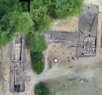
(4) Silchester (Calleva Atrebatum), Insula XXXIII (SU 6430 6240): excavation and re-excavation of the town baths took place; these had first been explored by the Society of Antiquaries in 1903–4.Footnote 91 The façade fronting on to the east–west street and an area of deposits, largely undisturbed by antiquarians and flanking the (secondary) east wall of the building, were excavated (fig. 31). At the south end of this trench the late (Period 6) hypocaust was re-investigated. To its east a further area, also largely undisturbed, was excavated to reveal the latest Roman silts sealing the LPRIA inner earthwork ditch. Evidence of a phase or phases pre-dating the earliest period of construction identified by the Antiquaries was discovered beneath both the earliest surface of the palaestra and the hypocaust on its north side. The first phase of the façade was constructed of Greensand blocks with brick string courses and fronted by a portico supported by columns of Painswick (Glos.) stone. The types of stone identified and the confirmation that the bricks are of the Little London ‘Neronian’ fabric support such a date for the earliest phase (surviving above foundations). The east end of the façade abutted a latrine which was extended after the east–west street had been laid down to occupy half the length of the frontage, with further modifications later in the Roman period. The latest Roman contexts were reached in the trench flanking the east wall of the baths beneath large dumps of CBM, much of which appears to derive from the late Saxon and medieval robbing of the baths.Footnote 92
Silchester: Insula XXXIII baths, overhead orthophoto showing all trenches.

WILTSHIRE
(1) Broad Blunsdon, land east of Sams Lane (SU 15448 90638): an evaluation identified a deposit potentially representing the remains of a prehistoric round barrow, although it may have been Roman in date. The deposit was truncated by at least 16 Roman cremation graves, indicating that, if it did represent a prehistoric barrow, it remained as a visible landscape feature into the Roman period. Two further cremation graves, a possible inhumation grave, a pit and a post-hole are also likely to relate to Roman funerary activity.Footnote 93
(2) Bromham, Bromham House Farm and Bromham Roman villa (ST 9765 6655 and 9708 6635): caesium magnetometer and Ground Penetrating Radar (GPR) surveys were conducted over a series of cropmarks at, and south-west of, Bromham House Farm. The magnetometer survey covered extensive tracts of arable and pastoral farmland containing a complex of enclosure ditches, boundaries, routeways and field-systems of possible Iron Age or Roman date together with three probable Bronze Age barrows. The surveys revealed evidence for extensive multi-period activity across the 27.7 ha investigated including, in the area immediately north of the suspected location of the villa, a regular pattern of rectangular enclosures and droveways typical of Roman activity. Probable industrial activity detected in the vicinity of roadways in the northern part of the survey may be linked with the settlement of Verlucio. The precise location of the villa (first noted in 1907) remains uncertain; it is possible that it may have been lost to relatively modern housing development along the A342 road corridor or may yet lie in adjacent farmland outside the limits of the 2018 survey.Footnote 94
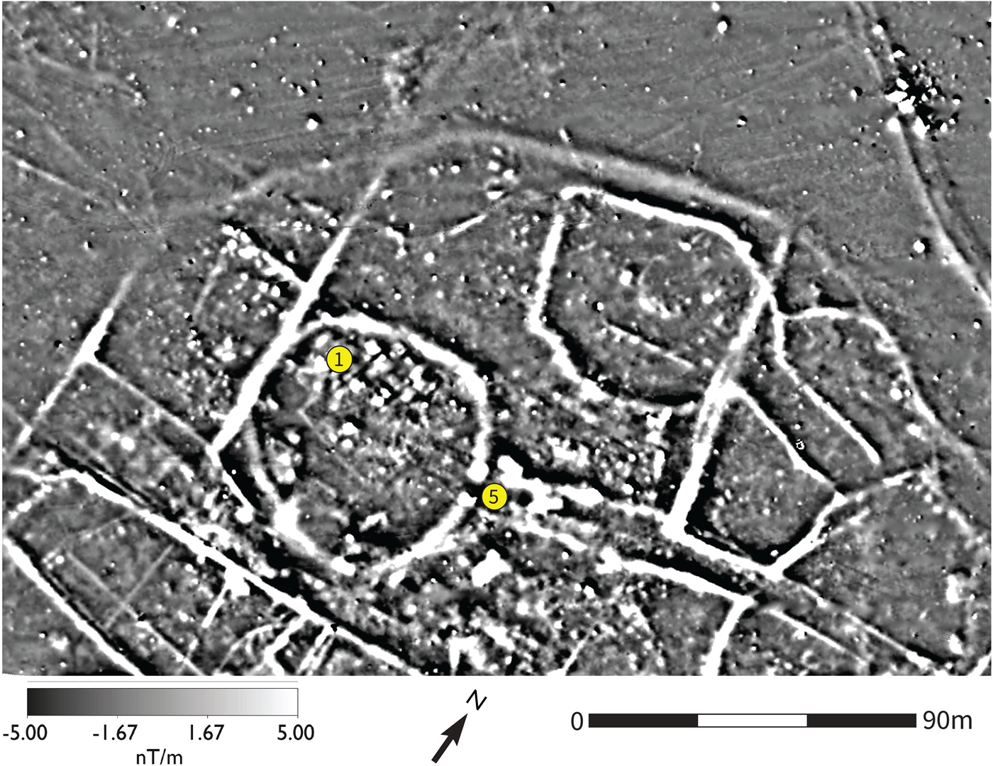
(3) Calne Without, Nuthills Roman villa (ST 9693 6834): caesium magnetometer and Ground Penetrating Radar (GPR) surveys were conducted over a series of cropmarks at the scheduled Nuthills Roman villa site (NHL 1004723). The 13.3 ha magnetometer survey covered the cropmarks of a rectilinear enclosure, possibly of Iron Age or Roman date, and an extensive complex of enclosure ditches and field-systems surrounding the site of the villa, whilst the GPR coverage (5.6 ha) targeted the site of the buildings (fig. 32). Magnetic survey confirmed the location of a double rectilinear enclosure identified from aerial photography and provided some additional detail, particularly within the inner ditch circuit. A much denser pattern of activity was revealed in the magnetic results to the south-east over the villa, enhancing the aerial record and suggesting a multi-phase complex of field-systems and boundaries centred around two sub-circular banjo enclosures. Evidence for Roman structural remains suggested by the magnetic survey was confirmed by the radar coverage, revealing a far larger complex of sizeable buildings than would, perhaps, be expected from a rural villa site. Comparing results from the two techniques suggests a strong correlation between the location of the buildings and the earlier banjo enclosures, perhaps indicating a greater ritual significance to the Roman settlement. The size, distribution and morphology of the buildings invite comparison with temple-complex sites such as Uley and Lydney.Footnote 95
Nuthills Roman villa. Survey extract showing a complex multi-phase landscape including two Iron Age banjo enclosures. The scheduled Nuthills villa (1) is located within the larger banjo enclosure and one building (5) appears to be built over the entrance to the banjo enclosure on the alignment of the approach ditches.

(4) Chippenham, land at North Chippenham (ST 9192 7507): an excavation identified two foci of Roman agricultural activity. Both included enclosures with internal divisions, some of which contained pits. The presence of probable waterholes suggests a stock management role for both, although the pottery assemblages from each hint at a possible chronological difference, with the northern area dating primarily to the second to third centuries a.d. and the area to the south dating to the third to fourth centuries. A field-system was identified between the two areas and the northern enclosures were related to a large east–west ditch that may have been a settlement boundary, although any associated settlement lay beyond the excavation limits.Footnote 96
(5) Wanborough, new Eastern Villages Southern Connector Road (SU 1966 8383): an evaluation identified a late Iron Age/first-century a.d. farmstead located on relatively high ground. By the mid-Roman period, this farmstead appears to have been replaced by a second farmstead to the south, identified during a preceding geophysical survey. Enclosure ditches, a cobbled surface, pits, post-holes and a stone drain/culvert primarily date to the mid-first to second century a.d. with evidence that the farmstead was extended to the east (possibly in the second to fourth centuries) by adding a further circuit of square enclosures with internal post structures. The finds assemblage from an associated field-system spans the early Roman period into the second to fourth centuries a.d.Footnote 97
SUPPLEMENTARY MATERIAL
For Supplementary Material for this article please visit https://doi.org/10.1017/S0068113X19000436