

Across most of Western Europe, agriculture was the most important economic sector before 1870 (the exceptions were England and Wales, Belgium, the Netherlands, and perhaps France).Footnote 1 This was particularly true of most German states and principalities, where the majority of people still found work at this time in the agricultural and extractive sectors and mostly lived in small and rural places. Footnote 2 The agricultural communities they lived in have been studied from various perspectives, but the degree of inequality and its causes are imperfectly understood. The main contribution of this paper is the provision of empirical evidence at the micro level that inheritance rules influenced inequality.
Using new data from an 1850s community survey, an Ortsbeschreibung, of more than 1,000 different German villages and towns, I provide new insights on such agricultural economies by examining the different inheritance traditions along with the landholding distributions in these places. Footnote 3 These communities could be found in the German principality of Hesse-Cassel, one of the three main Hessian states in the early modern period up to 1866. Footnote 4 Geographically it lay on and around an important line of division, a line between the north and eastern parts of Western Europe (e.g., Prussia, Bavaria, Scandinavia, Poland) where peasants used impartible inheritance traditions on the one hand, and the south and west of Europe where peasants instead employed partible inheritance practices (e.g., Baden, Württemberg, Belgium, France, Italy). Footnote 5 The Hessian region is thus a useful European region to study since one can find many villages that practiced impartible inheritance and lots that practiced the partible tradition, allowing for meaningful comparisons of the two traditions as they relate to landholding inequality.
To measure landholding inequality, I use data on how the land was distributed across households within communities and calculate a Gini coefficient for wealth inequality in each place. Footnote 6 These data provide a micro perspective and avoid possible ecological inference problems inherent with aggregate data used in inequality studies at the national or regional level. The microdata on Hesse-Cassel show that the middle 68 percent of the Ginis were between 0.47 and 0.76, a fairly large range in values, indicating that there was much variation in landholding inequality over the principality.
This study on Hesse-Cassel can add to the literature on historical European wealth inequality, which has grown in recent years. Table 1 lists some of these studies. Footnote 7 Much existing work concerns Britain, France, and the United States and is focused on income, not wealth inequality. Footnote 8
SOME ESTIMATIONS OF EUROPEAN WEALTH AND INCOME EQUALITY

Source: Author’s compilation.
German wealth inequality is not well documented, with the exception of a new study from Reference Alfani, Gierok and SchaffAlfani, Gierok, and Schaff (forthcoming), which uses property tax registers to estimate wealth inequality for a host of German cities and a few rural communities from the fourteenth through the nineteenth centuries. Footnote 9 My study covers a much larger and more comparable set of rural communities.
Further, most of what we know on historical wealth inequality in Europe is based on findings in urban centers and not in agricultural communities. Some social historians have found, however, based on small samples, that it was large in European cities and lower in rural areas in the premodern period (van Zanden Reference van Zanden1995, p. 645). Footnote 10 Does this rural-urban pattern hold within a given region and across hundreds of agricultural communities? Indeed, even among agricultural villages, landholding inequality turns out to have been quite a bit higher in the communities with larger populations. My results show that Hessian landholding inequality in the 1850s was related to the set of inheritance institutions used in the principality, norms that communities had adopted long ago and that were highly persistent. Those communities practicing impartible inheritance had higher inequality, as multi-variate regressions and maps will show. A similar analysis shows that emigration rates are significantly higher in impartible inheritance communities, suggesting that emigration is perhaps a response to higher inequality.
I commence here with a summary of the historical background of Hesse-Cassel, followed by a depiction of inheritance institutions. After a discussion of how I calculated landholding inequality for the principality and how it varied across the rural-urban landscape, I show how it was influenced by inheritance norms.
A LEGACY OF POLITICAL AND ECONOMIC BACKWARDNESS
The principality of Hesse-Cassel or Kurhessen was in the middle of present-day Germany and made up at least half of the present-day state of Hesse. On its borders were the current states of Lower Saxony and North-Rhine Westphalia to the north, Thuringia to the east, and Bavaria to the south. The Free City of Frankfurt and other Hessian states bordered Hesse-Cassel to the west and south.
Geographically it lay in the center of German states and in the crosshairs of various European conflicts over the centuries. The latter meant that some Hessian communities suffered some of the highest mortality rates in the Thirty Years War, although they had more than recovered to former population levels by the middle of the nineteenth century. Footnote 11 Politically, the principality had experienced autocratic and mercenary rulers: Frederick II, who leased his Hessian troops to King George of Great Britain during the American Revolutionary War, was perhaps the worst example. Footnote 12 Until the 1848 Revolution, successive generations of electors used censorship to keep a lid on unwanted ideas in print and to maintain an unenlightened society (Ohles Reference Ohles1992, pp. 15, 28, 164).
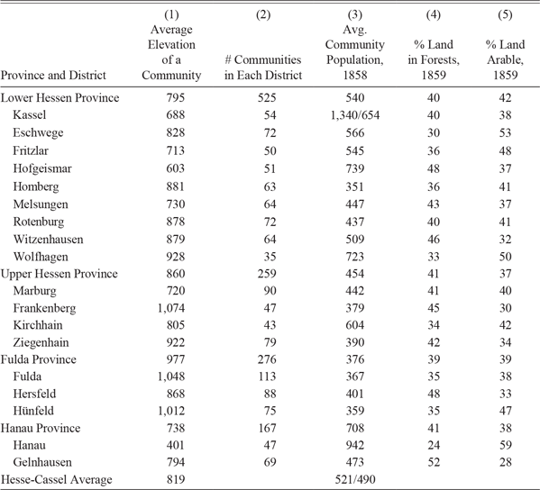
By the mid-nineteenth century, the principality of Hesse-Cassel served as a poster child for political and economic backwardness, as it was not as economically advanced as other areas in Germany, such as the Ruhr area in present-day North-Rhine Westphalia. Hesse-Cassel was known for its backwardness, poverty, and slow path to industrialization (Kukowski Reference Kukowski1995). Only three communities were cities of more than 9,000 people, and a bit fewer than 50 of the places in my set of 1,047 communities were officially designated as towns, while the rest were villages. Footnote 13 Table 2 shows the average population for 18 of the 21 districts (Kreise): with only a handful of districts with an average community population greater than 700 persons, one can see how very rural this principality was. In smaller villages, the majority of the population was engaged in the agricultural sector while, as would be expected, larger villages and towns hosted a greater variety of artisanal economic activities, and in a few, some manufacturing. Guild regulations of the principality prohibited the practice of most artisan trades in smaller villages, limiting the people in these places to common occupations like baker, butcher, and smith, and permitting the practice of the more specialized artisan trades only in the bigger towns and communities. The outdated guild law only fell by the wayside with Prussian annexation in 1866. Footnote 14 Manufacturing was mostly limited to textiles, iron and metal production, food processing, and chemicals, and was mostly to be found in the districts of Fulda, Hanau, Hersfeld, and Kassel in the contiguous part of the principality and Schmalkaden in the noncontiguous portion slightly east of Fulda. Footnote 15 Although the principality bordered Frankfurt, a prospering free city of 65,000 people in 1850, new roads and rail lines came relatively late, which meant slow economic progress. Footnote 16 Agriculture was thus the sector that employed the most people, and the land was the most important tangible asset, however illiquid it could be in certain communities.
ELEVATION, POPULATION, AND LAND-USE PRINCIPALITY OF HESSE-CASSEL

Notes: For Columns (1), (2), (4), and (5), data is provided for all existing communities in the districts; Column (3) includes only ones studied in this paper. Elevation is measured in Rhine feet, where one Rhine foot is 1.0297 of an American foot (Fox Reference Fox1976, pp. 390–91). The average community population is based on 1858 census records. For the District of Kassel, the average population (weighted) of 521 is shown with the capital city of Kassel (population 37,060) and without it. The district Schlüchtern, within the Province of Hanau, is not included in this analysis, but the Hanau Province subtotals include it.
Sources: (i) Columns (1) and (2), Landwirtschaftliche Zeitschrift für Kurhessen, “Kurhessens Boden und seine Bewohner,” by H. Möhl, 1865; (ii) Column (3), Population data: Hessen-Kassel. Kurfürstlich Hessisches Hof-und Staatshandbuch, 1860 (1858 census for Hesse-Cassel); (iii) Columns (4) and (5) from Kukowski (Reference Kukowski1995, table 17b, pp. 386–87).
INHERITANCE INSTITUTIONS IN HESSE-CASSEL
In a slow-growing and limited agricultural economy, the main form of wealth and main asset was land, and much of it was transferred over time to family members and not sold on open land markets. Footnote 17 Explaining the nature of the ownership and how the land was passed on to the next generation is key here. Ownership of land in this Hessian principality had long been determined by the Grundherrschaft institution (manorial system) common in the western and southern German states. Landlords were in general absent, and farmer peasants (from here on, termed “farmers”) had control over their lives, their land, and their labor. Footnote 18 Within the Grundherrschaft institution, farmers still paid dues, but they were rarely called on to perform labor services. By 1848, such obligations were irrelevant to many Hessian farmers as they took advantage of reforms to eliminate any services and fees permanently by paying an amount equal to 20 times the obligations. Footnote 19 This form of the Grundherrschaft institution in Hesse-Cassel was in stark contrast to East Prussia, where the “estate enterprise system” or Gutsherrshaft prevailed, a more servile setup (Wandschneider Reference Wandschneider2015, p. 793). Footnote 20 These two different land tenure institutions go back to the sixteenth century. Footnote 21
The principality of Hesse-Cassel was remarkable for how much land farmers controlled: in the nineteenth century, Hessian farmers owned almost all of the “non-forest” land in the principality, which included arable land, pasture, and gardens. Pedlow puts the percentage at 90 percent of the “non-forest” land, an enormous proportion. The nobility only owned about 7 percent of the entire area of the Hesse-Cassel principality, with more than half of this in forests, which is based on a survey of noble estates (Pedlow Reference Pedlow1988, pp. 9, 95–97). Peasants in other parts of Europe often controlled much less arable land than Hessian farmers did: for example, in eighteenth-century France, peasants owned only 35 percent of the land (Weis Reference Weis1970, p. 9).
Farmers used a few different inheritance norms to pass the land on to others upon retirement or their own death. Across the different German states, communities in the northern and eastern parts of Germany generally used Anerbenrecht, which consisted of unigeniture (single heir) or impartible systems in which one child, usually the eldest male, inherited most of the parents’ holdings. Footnote 22 In the western and southern parts of Germany, villages and towns typically practiced Realteilung or partible inheritance, under which each child (including women) would inherit some amount of land. The principality of Hesse-Cassel lay between the two divisions but predominantly practiced impartible inheritance. The practice within a given Hessian town or village, whether partible inheritance or impartible inheritance, was typically uniform across families, even if the next village or town used an alternative rule.
Recognition of this major line of division between impartible and partible regions was possible only after German government officials had completed formal surveys of inheritance practices in the late nineteenth century. Footnote 23 How this line of division came to be is not clear in the academic literature by any means. Proposed theories based on physical geography or ethnic origins can easily be refuted (Mayhew Reference Mayhew1973, p. 130). A more likely explanation is that German settlements formed in the early medieval period, during a time when the land was plentiful, settlements were spread out, the nobility was weak, and farmers preferred and adopted partible inheritance. Footnote 24 With time, more communities were founded to relieve population pressure, and peasants stuck with the partible tradition.
These places were more in the south and closer to the Rhine. In contrast, the communities formed in the later medieval period were more under the thumbs of noble control, who discouraged the splitting up of farms, which gave rise to impartible villages (Mayhew Reference Mayhew1973, pp. 130–31). Most relevant here, many scholars agree that whatever the origins, continuity seems to have been the theme: once the inheritance tradition for a community was established, over the centuries, little changed. One can observe, for the most part, great continuity in the geographic patterns of inheritance traditions among the German states. Footnote 25
For Hesse-Cassel, the 1850s community survey sheds light on inheritance traditions across the geographic landscape of the Hessian principality. The Historical Commission (Historische Kommission) of Hesse-Cassel requested all villages and towns to answer over two hundred questions, which covered the gamut of social and economic life in a community. The questions of interest here are those on inheritance practice and the local landholding size distribution. Footnote 26 Answers to these two questions form part of a large dataset I have used to study Hessian emigrants and the places they left. This dataset consists of answers to 50+ survey questions, transcribed into Excel spreadsheets in numeric terms as well as in a combination of German and English, covering over 1,000 villages and towns. Footnote 27 It is a rare and unique dataset for the period before 1870, particularly for its breadth and detail at the microlevel.
Typically a highly literate person in the village would complete the survey, such as mayors, local or regional government officials, foresters, teachers, and ministers, people who were intimately familiar with the local customs and practices. Footnote 28 Such a community representative provided an answer that described the local practice de facto, which avoids the problem of assuming practice from the de jure inheritance laws that Goy (Reference Goy1988, Reference Goy, Burguière, Goy, Ladurie and Tits-Dieuaide1997) warn against in the case of France and more generally. Footnote 29
Most villages and towns stated that they used one practice, either impartible or partible. Seldom did a community practice both impartible and partible traditions, but it did occur on occasion, mostly near the northeast districts of Rotenburg and Eschwege.
These data have nothing directly to say about how these traditions were enforced or about any lack of enforcement. A historian of Hesse-Cassel commented that “householders … were constrained by the customs of the village and the expectations of those who surrounded them” and that a further reason peasants stuck with the inheritance norms of their community was that it was not possible to get relatives to obey one’s own more specific directives after one’s own death (Theibault Reference Theibault1995, p. 92). An interesting comment comes from the village of Berfa (district of Ziegenhain), where the survey taker, a teacher by profession, commented matter-of-factly on the “custom” in his village as well as what was routine well beyond his community:
“It is the custom of the villages (as in the whole Hessian surrounding area) that only the oldest son, respectively the oldest daughter inherits the property.”
This was one of the few comments made in the Ortsbeschreibung on the particular traditions used well beyond a surveyor’s home village.
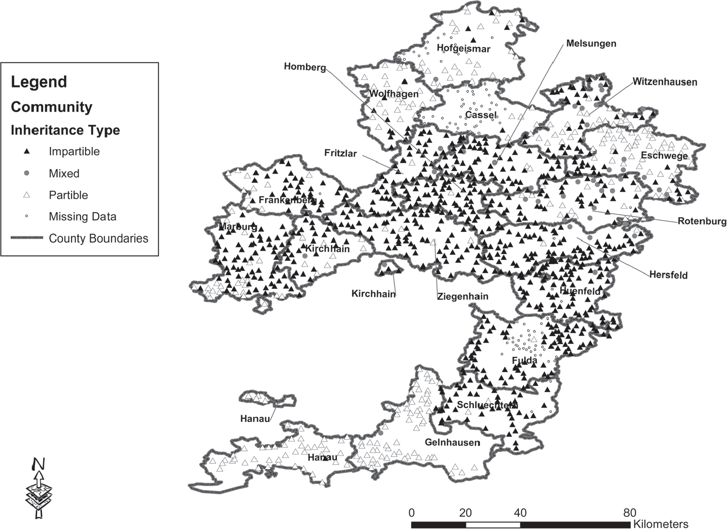
Figure 1 shows the spatial distribution, community by community, of inheritance institutions across the contiguous area of the principality, perhaps the first of its kind to display such specificity in local inheritance institutions. A white triangle denotes a partible inheritance village or town, while a black triangle indicates impartible inheritance. Some communities practiced both, and this I denote with gray dots. These places that practiced a mixture are mostly in the north and east parts of the principality. Missing data are denoted with a very small white circle. The map shows that inheritance tradition is somewhat consistent within an individual district (Kreis). While districts mostly practiced one or the other custom, almost all had both impartible as well as partible villages and towns within their borders. Out of the 1,047 villages and towns for which I have information from the community survey on the inheritance tradition, 68 percent of these communities used impartible inheritance, 28 percent used partible inheritance, and less than 4 percent employed some mixture of the two traditions. Footnote 30 The partible villages and towns in the southern districts of Hanau and Gelnhausen, and to some degree in the middle in Marburg, Frankenberg, and Kirchhain, reflect the principality’s location around the line of division, with partible customs to the south and west. Other districts in the northeast, like Eschwege and Witzenhausen, embraced partible inheritance; this was probably due to the influence of the customs in the Werra River valley, part of which were in the bordering state of Thuringia to the east, which practiced partible inheritance (Theibault Reference Theibault1995, p. 92).
VILLAGE AND TOWN INHERITANCE INSTITUTIONS IN HESSE CASSEL
Notes: This figure is based on information for 1,229 different communities, a larger set than used in the tables; inheritance information is described for 1,120 places and shown as missing for 109 other villages and towns.
Sources: Community data survey: Germany, HStAM, Bestand H3.

The community survey itself provides some evidence on how local customs evolved and indicates that villages and towns did not change their inheritance tradition very often. The survey did not ask for such information, but in several cases, it was volunteered and recorded, although this evidence is not complete for most villages and towns. Footnote 31 Most of the changes mentioned in the survey involved villages in Lower Hesse—the northern and eastern part of the principality. In total, five villages indicated that they had switched from partible to impartible, 6 villages indicated a switch from impartible to partible, and 4 villages switched from pure impartible inheritance to a mixture of traditions, thus showing a slightly greater tendency for villages to either abandon the practice of unigeniture in favor of equal inheritance or make room for a mixture of practices. Population pressure may have been an issue for the subset of villages that switched away from impartible practices, as this subgroup experienced a rather high population growth rate of 11 percent between 1832 and 1858, almost twice as high as the average Hessian village at 6 percent (not displayed in any table). Two villages mention that the enactment of the agrarian reforms (Bauernbefreiung), which took place in the 1830s and 1840s, encouraged them to change from unequal inheritance practices to equal customs. Footnote 32 These village societies may have also been trying to give their other children a chance in life. Allocating land to one child in the family can create wealth inequality within just one generation, which a number of economists have shown theoretically; a society starting from an equal distribution of wealth and practicing primogeniture can evolve quickly into an unequal society. Footnote 33 Some scholars even believe “extreme wealth inequality is inevitable” due to laws of nature (Scheffer et al. Reference Scheffer, van Bavel, van de Leemput and van Nes2017, p. 13154).
It appears that the particular inheritance tradition a village used had important consequences for the social, economic, and physical structures of its local society. According to some studies, wealth was more equally distributed across siblings and across genders in villages and towns that practiced partible inheritance. Footnote 34 In particular, Sabean’s study of the southwestern German village of Neckarhausen, which practiced partible inheritance, documents the power of women in local economic and social activity (Sabean Reference Sabean1998, p. 490). Benz argues that impartible villages, in general, promoted the concentration of wealth among a minority of men in the village, relegating the remaining adults to positions of a lower status (typically laborers) than that of their parents. Footnote 35
EVIDENCE ON LANDHOLDING INEQUALITY FROM HESSIAN VILLAGES AND TOWNS
To understand how inheritance institutions and land ownership may be related, one needs to measure first land ownership inequality for Hesse-Cassel. An advantage of using the Hessian land distribution data is that, aside from the nobility, they capture the wealth assets as measured by the arable land for all of the living heads of households in a community, even the poorest. Historically scholars have depended heavily on probate records to measure wealth, which provides a convenient list of assets and liabilities of a recently deceased person. Footnote 36 However, a limitation of probate records is that they only record property of those who have recently died and had assets and thus document the wealth of only a small percentage of the population at any given point in time. Footnote 37
Although the landholdings of the nobility were not recorded in the survey, this excludes only about 7 percent of the land across Hesse-Cassel owned by individuals (Pedlow Reference Pedlow1988, pp. 9, 95–97). Indeed, most communities did not have a noble person living within the village or town limits, so this exclusion does not affect their Gini coefficients. For the few places where nobility resided, the exclusion of noble landholdings will bias the landholding Gini coefficients downward and thus serve as a lower bound on wealth inequality. Still, nobles mostly owned forested land, and the Ginis in this study are based on arable land, so their degree of bias should be small.
My focus on land also excludes the wealth and capital assets of the minor manufacturing sector in Hesse-Cassel, such as factories, but this was a very small sector at the time and not relevant to the vast majority of citizens. The emphasis on land is appropriate for this time and place since it comprised the bulk of wealth in agricultural communities like those in Hesse-Cassel. Footnote 38 Even today, land makes up a large part of wealth portfolios in developing countries and less so in more developed economies. Footnote 39 Other studies on historical economies confirm the great financial significance of the broader category of real estate, of which land is a significant component in rural communities. Footnote 40
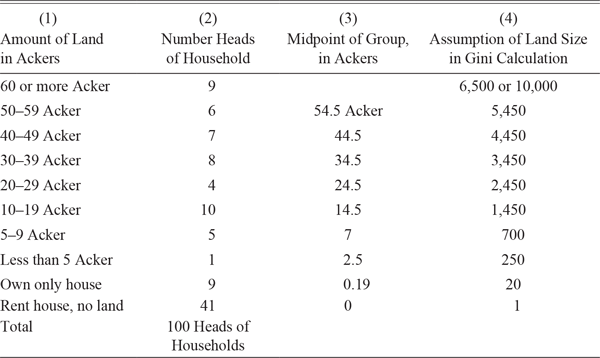
The survey asked villages and towns to complete over two hundred different questions, two of which are shown in the Online Appendix and from which I constructed a land distribution, with land measured in Acker Footnote 41 Here, the land distribution provides information on the size of landholdings and not on land values. I summarize this construction by using one village as an example. Consider the land distribution of the village of Raboldshausen in the Kreis (district) of Homberg, as shown in Table 3. Column (1) shows the land distribution, Column (2) gives the number of households in each group, Column (3) shows the midpoint of each data group (class), and Column (4) notes the assumptions I made to create non-zero integer values, as I elaborate on later. Raboldshausen had 100 heads of household, and the survey provides a snapshot of every village household’s holdings of land assets, including not only the large and small farmers but also artisans and laborers, the former (artisans) who usually had a bit of land and/or a house and the latter who often rented. Footnote 42
LAND DISTRIBUTION IN 1854 VILLAGE OF RABOLDSHAUSEN, DISTRICT OF HOMBERG

Notes: The biggest farm in this village was 70 Acker.
Sources: Community survey data: Germany, HStAM, Bestand H3.
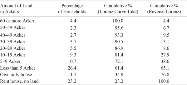
Table 4 combines the land distributions for all 1,047 Hessian villages and towns. The distribution is highly concentrated at the bottom, with 72 percent of households owning nine Acker (5.3 acres) or less. In fact, very few Hessian heads of households owned large farms. Large farms, those with 30 Acker (18 acres) or more, consisted of only 13 percent of all households. A rough calculation on how much of the total arable land the top 10 percent owned, from Table 4, a common statistic in inequality studies, shows that the top three land categories comprised a mere 9.5 percent of Hessian households; without accounting for differences in land prices across communities, this 9.5 percent of the population owned 56 percent of the arable land. Footnote 43 This is lower than what Kopczuk (Reference Kopczuk2015, p. 51) finds for the twentieth-century United States, where the share of total wealth owned by the top 10 percent ranges from 62 percent or so to a bit over 80 percent. Granted, these Hessian data do not include information on landed estates or other assets like physical structures (houses and barns), equipment, livestock, and so on, and merely express that much arable land, the main input to the agricultural production of grains, was held in the hands of very few.
LAND DISTRIBUTION TOTAL PRINCIPALITY OF HESSE-CASSEL

Notes: This is based on a total of 91,245 heads of household across the land distributions of 1,047 different communities.
Sources: Community survey data: Germany, HStAM, Bestand H3.
To use the land distribution data to construct Gini coefficients, I made a number of decisions. The most difficult was how to handle the right tails of the 1,047 different land distributions (the largest land amounts). Footnote 44 It is important to consider this issue carefully, as measures of inequality are highly sensitive to the shape of the right tail. Footnote 45 Knowing the size of the largest farm is helpful here in that it provides an extreme value on the right-hand side of the landholding distribution. In the case of the village of Raboldshausen, for example, nine households had farms of 60 Acker or more, and the biggest farm had 70 Acker. Footnote 46 Looking at the largest farms for each community for the entire principality provides additional perspective: for places with farms of at least 60 Acker (about 75 percent of the villages and towns), the average size of the biggest farm was 123 Acker, and the median size was 100 Acker. I thus calculated two sets of Gini coefficients, one assuming the largest land category to be 65 Acker (6,500 in the calculation), which I refer to as the more conservative measure (Method I), and a second assuming 100 Acker (10,000 in the calculation), which I call Method II. These two assumptions, especially the more conservative one, bias the land distributions towards equality; they also mean that the right tail is treated unvaryingly, which I adjust for in the Online Appendix.
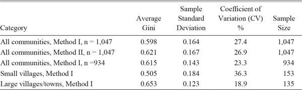
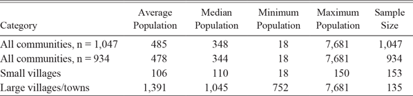
Finally, I calculate Gini coefficients for all of the 1,047 villages and towns; results are displayed in Table 5A; Table 5B provides summary statistics on village and town population data for 1858. Details on how I used the land distribution data to calculate Gini coefficients on grouped data are in the Online Appendix. I performed two sensitivity checks on the Gini coefficients on a subsample of 40 communities, first checking whether assigning quality-adjusted land prices mattered for the Ginis, and second how I treated the largest farms in the land distribution, something the community survey was not expansive enough on. Adding prices did not matter much, while the second check suggests that the Ginis I have calculated are slightly below what they should be in villages and towns with a lot of large farms. Details are in the Online Appendix.
GINI COEFFICIENTS

Notes: All Gini coefficients calculated using Ineqdeco command in Stata. Method I is more conservative (assumes largest farmer has 65 Ackers). Small villages defined here as having 150 or fewer people out of set of 934 communities, and large villages/towns defined as having 750 or more people out of the same set.
Sources: (i) Community survey data: Germany, HStAM, Bestand H3; (ii) Population data: Same as Table 2.
SUMMARY STATISTICS OF VILLAGES AND TOWNS, 1858 POPULATION

Notes: I use the 1858 population census. Small villages are defined as having 150 or fewer people out of set of 934 communities, and large villages/towns are defined as having 750 or more people (out of same set).
Source: Population data: Same as Table 2.
The more conservative method yields an average Gini coefficient of 0.598 (standard deviation of 0.164), while the second method yields an average Gini of 0.621 (standard deviation of 0.167), fairly close results. Both sets of Gini distributions have large standard deviations, showing that variability in inequality was large across communities: for Method I, approximately 68 percent of the Gini coefficients lay between the values of 0.43 and 0.76, a fairly large range.
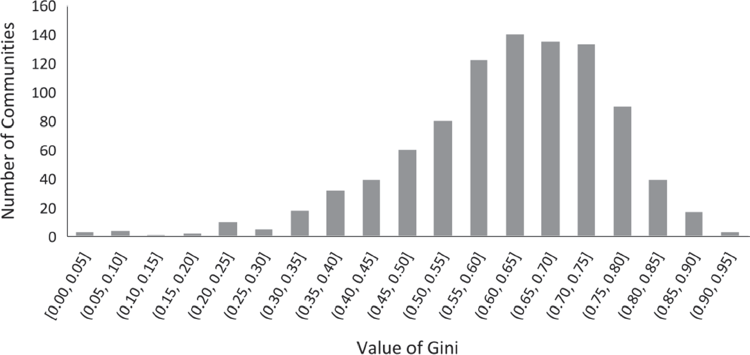
There is concern that 113 communities may have measurement error in their land distributions, about 11 percent. In some cases, it appears that the survey taker had filled out the land distribution in a haphazard way; in more cases, it was clear that some villages and towns had farmers missing and others had landless missing from their distributions. Where farmers were missing, the Gini coefficient was too high; where landless were missing, it was too low, which was actually one of the most common issues. Footnote 47 As a robustness check, I took the villages and towns with suspected measurement error out of the analysis and narrowed the data down to a set of 934 communities. The remaining 934 Gini coefficients are ones that I believe capture an accurate picture of the Hessian land holding distributions. The ones I eliminated can be found all over the principality, in many different districts, and thus I believe I am eliminating biases originating with the way the data was collected and specifically with the individual surveyors for each village and town and not with any geographical or socioeconomic feature. The third row in Table 5A shows the new result, with a mean Gini of 0.615 and a standard deviation of 0.143, meaning that approximately 68 percent of the Gini coefficients lay between the values of 0.47 and 0.76, a slightly smaller range than with the larger set of data. Footnote 48 Figure 2 shows what the distribution looks like for the 934 villages and towns: it has one peak, around the mean of 0.615, with a lot of communities with Ginis between 0.55 and 0.75, 59 percent to be precise. The left tail is long, characterizing this distribution as mildly left-skewed, and signifying that a number of villages and towns, but not too many, enjoyed some degree of equality. There was definitely a substantive degree of variation in landholding inequality across the principality.
DISTRIBUTION OF GINIS, METHOD I
Notes: These are the Ginis for the scaled down set of 934 communities.
Sources: Community data: Germany, HStAM, Bestand H3.

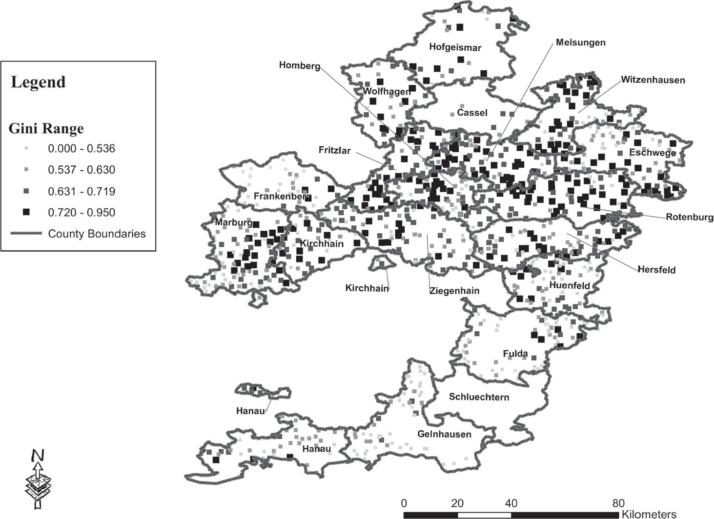
These results are comparable to those of Reference Alfani, Gierok and SchaffAlfani, Gierok, and Schaff (forthcoming, Table 2): for their entire set of German cities, towns, and rural communities, they calculated an aggregated Gini index of 0.617 in 1800, and for just rural Germany they calculated an aggregated Gini index of 0.593 in 1850. Results for Hesse-Cassel are also close to but somewhat below those for parts of early modern northern Italy, where Gini coefficients lay between 0.600 and 0.940, based on the work of Alfani and co-authors, where arguably, the nature of communities was more urban. These findings, as well as others from various scholars, are shown in Table 1. Estimates for contemporary inequality provide a different context for the results for Hesse-Cassel. Davies et al. (Reference Davies, Susanna, Anthony and Edward2011) provide information on wealth for 229 different countries for the year 2000 and estimate that Gini coefficients for wealth distributions lay between 0.547 and 0.802 Footnote 49 Figure 3 shows a map of the spatial distribution of inequality in the principality of Hesse-Cassel in the 1850s, with the Gini data divided up equally among the four separate bins. Footnote 50 Darker squares represent villages and towns with high Gini coefficients, and the progressively lighter squares show more equal communities (with progressively lower Gini coefficients). Two features on the map are noteworthy: first, all over the principality, there are spots where villages with high wealth inequality were situated within a couple of kilometers of villages with much lower wealth inequality. Second, clusters of low inequality, as well as high inequality villages and towns, existed. The first pattern may reflect the population size of the individual villages and towns; it was perfectly normal for a large community to be near a small one. The second pattern, the clusters, suggests that a more refined explanation of inequality could be helpful and that this may be related to inheritance patterns.
VILLAGE AND TOWN GINI COEFFICIENTS
Sources: Community data survey: Germany, HStAM, Bestand H3.

The Correlation between Inequality and Institutions
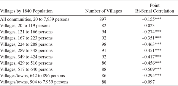
Did the particular tradition that was used to pass on the property from one generation to the next matter for a village’s or town’s inequality level? Quite possibly! Table 6 shows the point bi-serial correlations between a community having a partible inheritance institution and landholding inequality (Gini coefficient). Footnote 51 Looking at the entire set of villages and towns, from the smallest of 20 persons to the largest of more than 7,000 people (the university town of Marburg), a hodgepodge of economic communities, the correlation is −0.155. Footnote 52 Sorting the data by population size and dividing the villages and towns into 10 groups of common population sizes, many of the correlations for these 10 groups are both strong and statistically significant: the group of villages from 517 to 640 persons, for instance, has a correlation of −0.509. The strongest negative correlations are for villages with roughly 225 to 640 people. Hence, for similarly-sized agricultural villages (roughly 225 to 650 in population size), where wealth was primarily locked up in land, higher inequality was associated with the villages that used impartible inheritance.
POINT-BISERIAL CORRELATIONS OF INHERITANCE AND INEQUALITY BY COMMUNITY POPULATION SIZE

* = Significant at the 10% level.
** = Significant at the 5% level.
*** = Significant at the 1% level.
Sources: Community survey data: Germany, HStAM, Bestand H3.
Another way to approach the relationship between inequality and inheritance is to estimate a model of inequality on inheritance and other exogenous village and town variables:
Gini i = β 0 + β 1 Inheritance i + γX i + δ p + δ d + ε i
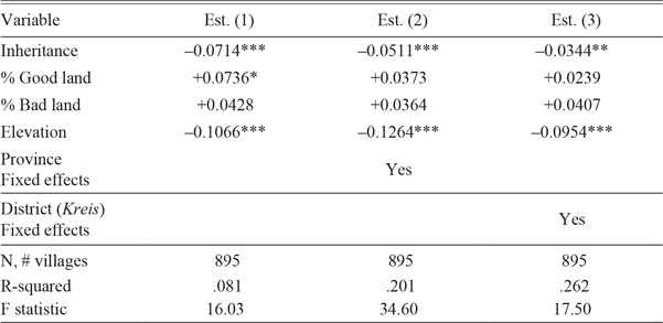
Of central interest is the wealth gini of the community, Gini i , which is regressed on Inheritance i , (equal to one if the village or town practiced partible inheritance and zero if impartible). X i . is a vector of exogenous controls, including percent good quality land in the community, percent bad quality land, and elevation. δ ρ and δ d represent province and district fixed effects respectively. Results are shown in Table 7A: in all three estimations, with and without controls, wealth inequality is highly negatively associated with partible inheritance: the impartible villages and towns, where one child inherited the land, experienced higher degrees of landholding inequality.
REGRESSIONS OF INEQUALITY, O.L.S.

Notes: Significance levels: *p < 0.1, ** p < 0.05, and ***p < 0.01. Errors are robust standard errors. Variables: (i) Dependent variable is Community Gini; (ii) Inheritance: Equal to one if partible, zero if impartible; (iii) % Good land is percentage of good quality land in community; iv) % Bad land is percentage of bad quality land in community; v) Elevation: natural log of elevation in Rhine Feet; vi) Fixed effects: there were 4 provinces and 21 districts, but only 18 districts are used.
Sources: (i) Community survey data: Germany, HStAM, Bestand H3; (ii) Elevation Data, Landwirtschaftliche Zeitschrift fur Kurhessen, “Kurhessens Boden und seine Bewohner,” by H. Möhl, 1865.
It is also helpful to look at maps of the contiguous part of the Hesse-Cassel principality showing for all of the villages and towns inheritance institutions in Figure 1 and landholding inequality in Figure 3. Footnote 53 Clusters of high Gini coefficients, black squares signifying high inequality, tend to overlap with the areas where impartible inheritance was practiced. Precisely 233 communities had Gini coefficients at 0.72 or above, and 74 percent of these villages and towns used impartible inheritance. The lighter and smaller squares in Figure 3, representing low inequality, tend to coincide (but not perfectly) with the lighter and smaller triangles in Figure 1, representing the villages and towns, which practiced partible inheritance. One finds fewer instances of high inequality in the districts with substantial numbers of villages and towns that practiced partible inheritance, such as Eschwege in the northeast, Wolfhagen and Hofgeismar in the very north of the principality and Hanau and Gelnhausen in the south. Further, the district of Eschwege in the northeast practiced mostly partible inheritance, with the exception of some communities along its western border; of the 18 villages that had a Gini above 0.71, hence a black square on Figure 3, 44 percent used primogeniture. The districts of Hanau and Wolfhagen deserve special consideration: both contained many villages where a very large percentage of the land, more than 50 percent (see Table 2), was devoted to arable land; the practice of partible inheritance may have encouraged Hessians in these places to devote greater areas to arable land. Footnote 54
Emigration and Inheritance Institutions
Impartible inheritance appears to have fostered unequal ownership of land assets. The implications for non-heirs are known with certainty, but there are some other likely effects: non-heirs may have been more likely to be less wealthy than their sibling who inherited; it may have discouraged marriage for the non-heirs and postponement of it for the heirs. Footnote 55 Further, some non-heirs sought to leave their home villages or towns to avoid the very real possibility of downward mobility that came with adulthood. Internal migration within the principality was not that easy. Moving to another village or town was possible for women through marriage or for a young man (farmer-to-be) marrying into a farm family with only daughters. For a man to establish himself anew in a different community required that he procure legal permission from the new village or town, which also involved a show of financial assets. No community wanted the burden of another village’s poor (Auerbach Reference Auerbach1993). Footnote 56 Emigrating out of the principality, especially to the United States, was another strategy for non-heirs in impartible places and one that almost 50,000 Hessians pursued between 1832 and 1857. Emigration to the United States meant a chance at a very different life, which included working for a higher real wage than could be found in Hesse-Cassel, marrying earlier in life and thus possibly having children, and perhaps eventually owning land or starting a business (Hatton and Williamson Reference Hatton1998; Wegge Reference Wegge2002).
It is thus no surprise that emigration rates to places outside the principality, mostly to the United States, in the 1840s and 1850s from a sample of Hessian villages, were significantly higher from the impartible villages than from the partible villages (Wegge Reference Wegge1999). For the set of 934 villages and towns studied in this paper, impartible communities lost on average 5.8 percent of their population to emigration between 1852 and 1857 compared to 4.9 percent for partible villages and towns. Statistics over a longer period, 1832 to 1857, show a similar pattern: the average emigration rate from impartible villages and towns was 8.8 percent and 7.9 percent from partible places. Footnote 57 Emigration served as an important strategy for families who could afford it or had relatives who emigrated previously and were assisting because it allowed these families to send their children (non-heirs) and leave their home communities that offered little to no chance of wealth accumulation or upward economic mobility. Footnote 58 Evidence exists that previous emigrants, ones who had emigrated in earlier years, played some relevant role: by 1857, almost half of Hesse-Cassel emigrants leaving could be tied to a family member who had left in a previous year from the same community (Wegge Reference Wegge1998). Most of these previous emigrants, certainly those who had left by 1853 or 1854, had an attenuating effect on the Gini coefficient and the level of landholding inequality in their own villages and towns. This may help explain why the correlation between inheritance and inequality (Table 6) is not stronger than −0.507.
Some further evidence comes from estimating a model of village and town emigration rates on inheritance and other exogenous community variables:
ER i = β 0 + β 1 Inheritance i . + γΧ i . + δ p + δ d + ε i
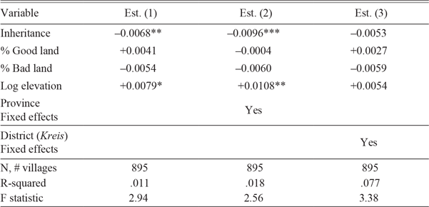
Here, ER i is the village or town emigration rate from 1852 to 1857 and is regressed on Inheritance i , the same X i of exogenous controls as in the previous regression, and the same set of fixed effects. Results are shown in Table 7B. The first and second estimations, with a negative coefficient on inheritance, show that village and town emigration rates were highest in the impartible communities and that this result is statistically significant. Footnote 59 This is evidence that people abandoned the principality from impartible places at higher rates, possibly because of a lack of economic opportunities.
REGRESSIONS OF EMIGRATION, O.L.S.

Notes: Significance levels: *p < 0.1, ** p < 0.05, and ***p < 0.01. Errors are robust standard errors. Variables: (i) Dependent var. is total community emigration rate from 1852 to 1857; (ii) Inheritance is one if partible, and zero if not; (iii) % Good land is percentage of good quality land in the community; (iv) % Bad land is percentage of bad quality land in the community; (v) Elevation: Natural log of elevation in Rhine feet; (vi) Fixed effects: There were 4 provinces and 21 districts but only 18 districts are used.
Sources: (i) Community survey data: Same as Table 7A; (ii) Elevation data: Same as Table 7A; (iii) Data on emigrants: Germany, HStAM, Bestand 16 and the HESAUS data in Auerbach (Reference Auerbach1987–1988); (iv) Population data: Hessen-Kassel. Kurfürstlich Hessisches Hof-und Staatshandbuch, 1843 (1840 census), 1852 (1849 census), 1858 (1855 census), and 1860 (1858 census).
The Divide between Large and Small Communities
The options for work in the smaller Hessian communities were confined to farming and a short list of artisan crafts as defined by law, thus limiting the types of occupations to farmers, simple artisans, and laborers. Larger communities with more economic activity and sometimes officially designated as towns offered citizens a greater variety of economic opportunities: they had more artisans per capita and were more likely to have factories, with 7.5 percent of Hessian communities having one or more factories. Footnote 60 Of the set of 934 communities examined here, 35 were officially designated as towns.
With agriculture thus the chief economic sector through much of the principality, variation in elevation, valleys, and soil types created differentials in agricultural productivity across the region. A contemporary described the most fertile areas of the principality as being the lowlands near the Main River (districts of Hanau and Gelnhausen), the lowlands near the Lahn River (districts of Marburg and Kirchhain), and to some degree the districts of Eschwege and Witzenhausen in the north near the Werra River (Landau Reference Landau1842, pp. 54–55). The lowest agricultural yields were found at higher elevations, including the districts of Frankenberg and Fulda. Footnote 61 These districts can all be found in Figure 1. Elevation strongly influenced local agricultural yields, and thus, how many people the local land could support. Footnote 62 Table 2 shows the average elevation and 1858 population size of villages and towns in 18 of the 19 districts in the contiguous area of Hesse-Cassel. The correlation between elevation and population size was strong and negative (−0.76), implying that communities at higher elevations could not support as many people. Footnote 63 Districts with more land in forests also had less arable land (correlation of −0.91). Footnote 64
So, while smaller communities tended to be at higher elevations, we also know from Table 5A that these smaller villages were, on average, more equal. I calculated separate Gini distributions for the small villages (150 people or fewer) and large places (750 people or more) in 1858, displayed in Table 5A. I chose the value of 750 since Walker (Reference Walker1971, p. 30) describes the lower population limit of German hometowns at this number. Smaller villages make up 16 percent (153 communities) and larger places 14 percent (135 communities) of the 934 villages and towns; while only 35 of the 135 larger places were official towns, they shared some economic features. The average Gini coefficient for smaller villages is substantially lower at 0.51, compared to the higher one for larger places at 0.65. A comparison of means test shows that these means are statistically different at the 1 percent significance level and thus derive from different distributions: the Gini distribution for small villages, centered around a value of .505 is more spread out, evident from the higher Coefficient of Variation value, and thus encompasses more low values of landholding Ginis; the Gini distribution for large communities, in contrast, is more narrow but centered around a much higher average of 0.653. Very low inequality in terms of land holdings is virtually non-existent among these larger communities.
More evidence comes from estimating this model of village and town inequality on inheritance and other exogenous community variables, including two indicators of urbanization:
Gini i . = β 0 + β 1 Inheritance i . + γ i Χ i + γ 2 Town i + γ 3 Markets i . + δ p + δ d + ε i
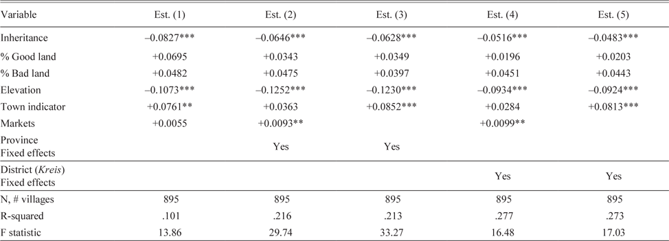
Here, Gini i ., is village or town inequality in land holdings for Community i and is regressed on Inheritance i , the same X i . of exogenous controls as in the two previous regressions, and the same set of fixed effects. Also included is the variable Town i , which is equal to one if a community was officially designated as a town, and zero otherwise. This special classification, often going back centuries, conferred rights to allow more types of high-skilled artisans to operate and in some cases markets. In some of the estimations, I also include the variable Markets i , which measures how many markets were allowed to operate in a community. The number of markets was regulated from a higher government level, and although it is potentially endogenous, including this variable is still revealing. Table 7C displays the results and shows that indeed, landholding inequality was higher in places designated as towns or that held more markets, both indicators of larger and more populated places; this result holds up no matter which controls are used in the estimation. Footnote 65 In addition, the main result in Table 7A still stands, namely that inequality was higher in communities practicing impartible inheritance and those at higher elevations.
REGRESSIONS OF INEQUALITY, O.L.S.

Notes: Significance levels: *p < 0.1, ** p < 0.05, and ***p < 0.01. Errors are robust standard errors. Variables: (i) Dependent variable is Community Gini; (ii) Inheritance: Equal to one if partible, zero if impartible; (iii) % Good land is percentage of good quality land in the community; (iv) % Bad land is percentage of bad quality land in the community; (v) Elevation: Natural log of elevation in Rhine feet; (vi) City: Equal to one if community designated as a town, zero otherwise, where the designation conferred rights to allow more types of high-skilled artisans to operate; (vii) # Markets a community was entitled to hold; (viii) Fixed effects: There were 4 provinces and 21 districts but only 18 districts are used.
Sources: (i) Community survey data: Same as Table 7A; (ii) Elevation data, same as Table 7A.
A similar relationship between population and inequality has been documented for various places in Europe in the late medieval, early modern, and even modern times, namely that greater inequality could be found in urban places, including Alfani (Reference Alfani2015) for Piedmont, van Zanden (Reference van Zanden1995) on Holland, and the work by Alfani and Ammannati (Reference Alfani and Francesco2017) and Herlihy (Reference Herlihy, Abrams and Wrigley1978) for Tuscany, and Piketty, Postel-Vinay, and Rosenthal (Reference Piketty, Postel-Vinay and Rosenthal2006) on France. Footnote 66 Economists have shown both empirically and theoretically for contemporary societies that places with larger populations have also been found to have greater inequality. Footnote 67
CONCLUDING REMARKS
This paper focuses on the traditions Hesse-Cassel farmers used to pass arable land on to the next generation and its distribution in the 1850s in more than 1,000 villages and towns. Hesse-Cassel straddled the division between impartible and partible, allowing the examination of the effects of inheritance on landholding inequality in otherwise similar communities. Hessians used both partible and impartible traditions to transfer property to their children, with the latter the most common practice. These were long-standing norms that had been in place for centuries, with little evidence that communities changed their practices much along the way.
A novel dataset of over 1,000 villages and towns was constructed with great effort from a contemporaneous community survey. An important advantage is that it includes landholding size information for almost all householders in each village and town. With arable land the most valuable capital asset in agricultural economies, I measured landholding inequality for 934 Hessian communities. The average Gini coefficient was equal to 0.615 but lower for rural villages and higher for larger ones as well as for towns. At the aggregate level, the land distribution for Hesse-Cassel was concentrated at the bottom, with 72 percent of households owning nine Acker (5.3 acres) or less. There was a large degree of variation across communities and, in reference to recent work by van Bavel, even some “islands of equality” (van Bavel Reference van Bavel and Nigro2020). This great variation is only discernible with microdata.
In parts of the principality, both clusters of high inequality and low inequality could be found, with the former mostly in a swath in the middle of the principality from the west in the district of Marburg to the east in the district of Rotenburg. Clusters of low inequality were found frequently in the districts where partible inheritance was practiced. The correlation between inheritance and landholding inequality was negative and highly statistically significant, such that higher inequality was associated with impartible inheritance. Regressions of inequality on inheritance and other exogenous controls further show that inheritance norms had a part in causing higher landholding inequality. In summary, the correlations, the maps, and finally the regressions make a case for an important relationship between inheritance rules and wealth inequality. A mitigating factor is that Hessians, especially young people, who could not find their fortune at home, had been leaving for other German states and countries, but mostly the United States, since the year 1832. The higher emigration rate for impartible communities than that of the partible ones, shown in this paper through summary statistics and regressions, helped reduce landholding inequality and more so in the former. An additional finding is that inequality was higher in communities with larger populations, which echoes the findings of both economic historians and economists that inequality was and is higher in more populated places.
Although the literature on historical Western European income and wealth inequality has been growing, wealth inequality in Germany is not as well-documented. Inequality in agricultural communities in this time period in Europe is also not well-studied. Thus, this story of Hesse-Cassel, as representative of the poorer, largely agricultural places that predominated in Germany at the time, adds to the literature on historical inequality in undeveloped agricultural economies and suggests that there are important links between inheritance rules and landholding inequality. These links are worth exploring and understanding better.