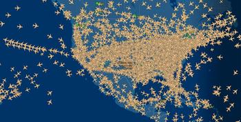


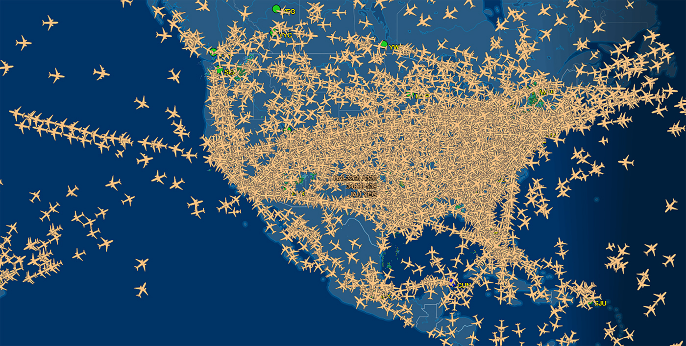
Let me begin with a map of a kind that I first saw on television (see figure 1). Early in 2019, while the US government was shut down for thirty-five days, one of the anchors on MSNBC used a map like this to highlight one very precarious aspect of the situation: the air traffic controllers who keep those thousands of planes in the air were doing so without pay. What the image reminds me of, though, is thirteenth-century India. It is a great way to picture the world portrayed in the text that this essay will discuss. The text, entitled Līḷācaritra, is a biography of Cakradhar compiled by his followers in the last quarter of the thirteenth century.Footnote 1 The close attention to place in the Līḷācaritra is key to understanding not only this text from long ago and far away, I believe, but also the attachment to particular places in other highly mobile worlds, including our own.
Planes in the air over the United States (FlightAware 2019). Printed with the permission of FlightAware.
The Līḷācaritra is the first literary text that was written in Marathi, the language of the modern state and historical region named Maharashtra. Composed before 1287 CE, it predates all other extant literature in Marathi, including the more widely known Jñāneśvarī (1290 CE; Tuḷpuḷe Reference Tuḷpuḷe and Gonda1979, 330), Jñāneśvar's Marathi commentary on the Bhagavadgītā.Footnote 2 Like a great deal of the earliest Marathi literature, the Līḷācaritra originated within a community of people who produced and preserved their literature out of bhakti, religious devotion.Footnote 3 One principal strand of Old Marathi bhakti literature, that of the Vārkarīs, features the works of poets devoted to the god Viṭṭhal or Viṭhobā of Paṇḍharpūr, whom they see as a form of Kṛṣṇa (Dhere Reference Dhere and Feldhaus2011). The Līḷācaritra stands at the beginning of the other principal strand of Old Marathi literature, that of the Mahānubhāvs. The Mahānubhāvs consider Kṛṣṇa, the teacher in the Bhagavadgītā, to be a “walking, talking” incarnation of the one supreme Lord, Parameśvar; Cakradhar, the subject of the Līḷācaritra, is another.Footnote 4
Unlike most Vārkarī literature and a good deal of Mahānubhāv literature—indeed, unlike much premodern literature in most Indian languages—the Līḷācaritra is written in prose, not verse. Moreover, the prose style of the Līḷācaritra is quite simple and direct—“telegraphic,” in Raeside's (Reference Raeside1976, 597) term. Many bhakti biographies composed in the early forms of the modern languages of South Asia are more properly described as hagiographies.Footnote 5 Unlike these, the Līḷācaritra lies toward the biographical pole of what Richard Eaton has suggested is a “continuum” between biography and hagiography.Footnote 6 The Līḷācaritra’s tone is matter-of-fact; it pays a great deal of attention to the details of everyday life; what few miracles it tells about are, for the most part, relatively unremarkable;Footnote 7 its subject is not presented as a model of exemplary human behavior. In these ways, it is unlike many hagiographies. Moreover, for the compilers of the Līḷācaritra, its subject is not a saint, a “holy person” (Greek, hagios): he is God, a divine incarnation.
Because of its attention to daily life, its matter-of-fact tone, and its simple prose style, the Līḷācaritra is an excellent source for social and economic history, as well as for the history of material culture. For its compilers, though, and for its many reverent Mahānubhāv readers over the centuries, it is most importantly a detailed record of everything anyone could remember about what its subject did and said as he wandered around Maharashtra at the end of the thirteenth century. Why did the community that produced and preserved this remarkable text care about the many details it records?
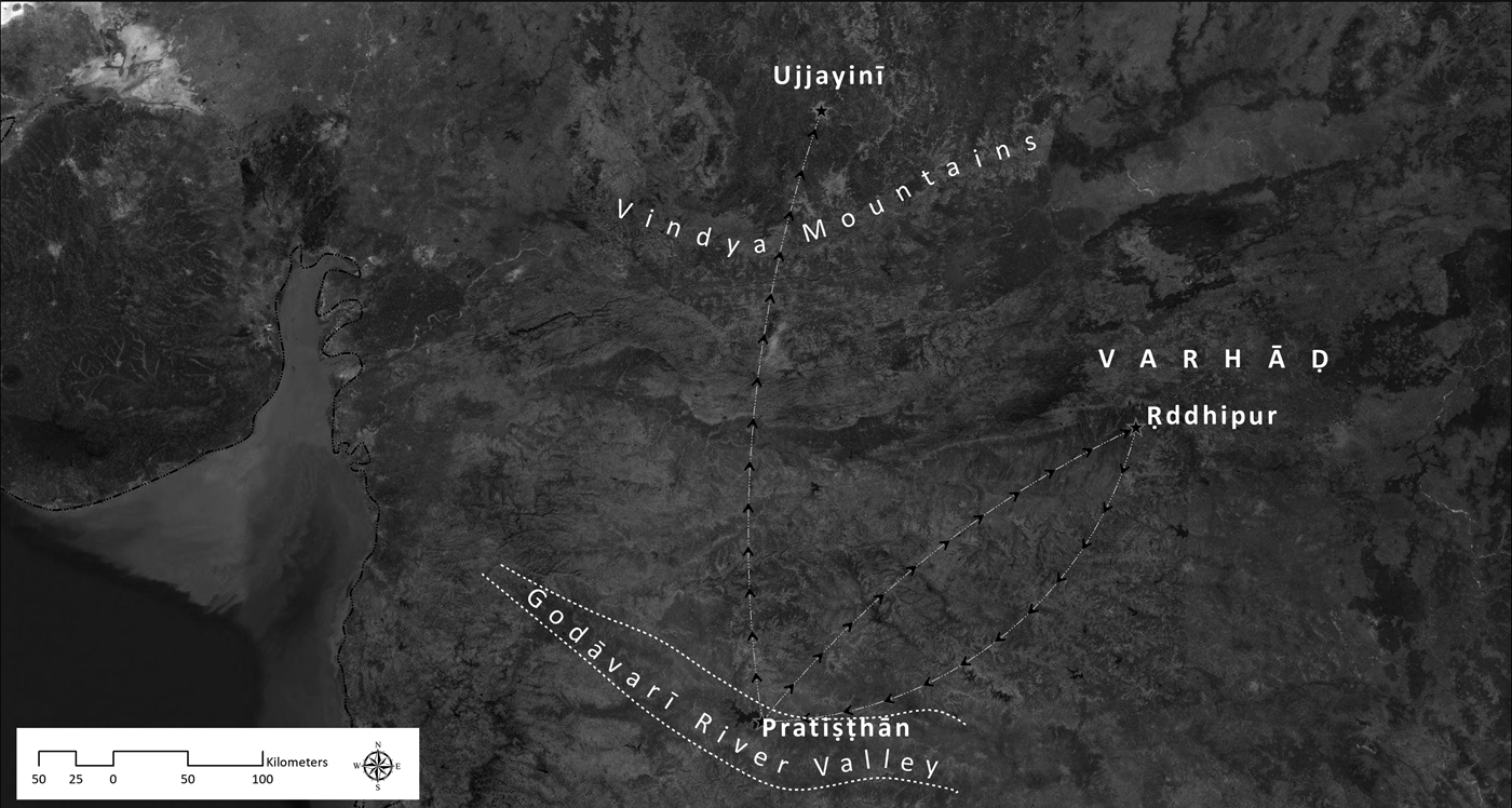
According to Mahānubhāv theology, the key to liberation from the cycle of rebirth and suffering is to experience the presence, the sannidhān, of a human incarnation of Parameśvar.Footnote 8 For Mahānubhāvs, sannidhān is not merely a formal, theological requirement but an emotionally powerful attachment. Since the late thirteenth century, however, the sannidhān of such an incarnation has been elusive. Cakradhar disappeared in 1273 CE, walking north from Pratiṣṭhān, on the Godāvarī River (see figure 2). After he was gone, Cakradhar's principal disciples went to stay with his guru, Śrīprabhu, in Ṛddhipur (Smṛtisthaḷ 3–4; Feldhaus and Tuḷpuḷe Reference Feldhaus and Tuḷpuḷe1992, 70–71). Fourteen years later, in 1287, Śrīprabhu died. Cakradhar's leading disciples returned to the Godāvarī valley and bowed to a series of places where Cakradhar had stayed (Smṛtisthaḷ 5; Feldhaus and Tuḷpuḷe Reference Feldhaus and Tuḷpuḷe1992, 71). They thus inaugurated a tradition of pilgrimage that flourishes to this day. In addition, they began a tradition of venerating relics: they removed, for example, the wooden threshold of a temple where Cakradhar had stayed, and made the threshold into bowls and beads.Footnote 9 During the fourteen years after Cakradhar disappeared and before Śrīprabhu died, Cakradhar's followers also created a literary tool for remembering him: the Līḷācaritra.
Cakradhar's departure and the first Mahānubhāv pilgrimage. Map by Nikhil Shejwalkar. Sources: Esri, DigitalGlobe, GeoEye, Earthstar Geographics, CNES/Airbus DS, USDA, USGS, AeroGRID, IGN, and the GIS User Community.

The Līḷācaritra consists of a series of approximately 1,000 episodic chapters called līḷās (divine deeds). It was compiled by a disciple named Mhāïṃbhaṭ, sometime between Cakradhar's departure and Śrīprabhu's death, on the basis of Mhāïṃbhaṭ’s own recollections and those of others who had spent more time than he had with Cakradhar.Footnote 10 A few of the Līḷācaritra’s chapters do have a tendentious theological message, demonstrating Cakradhar's divinity, for example, or portraying him imparting the teachings preserved in the Sūtrapāṭh, the collection of his aphorisms (Feldhaus Reference Feldhaus1983).Footnote 11 For the most part, though, the Līḷācaritra simply recounts, in a matter-of-fact way, the many small events and routines of Cakradhar's day-to-day life: where he went, where he sat, what he did, who came to see him, what they asked, what he said, and—surprisingly often—what he ate. Sometimes even the recipes are included.
One aspect of everyday life that seems to have been extremely important to the authors of the Līḷācaritra is what we would call geography.Footnote 12 In the rest of this essay, I will try to explain what I mean by this and why I think it is important.
Geography
Geography is central to the Līḷācaritra in several ways. First, the text identifies precisely numerous places where Cakradhar sat, ate, slept, and stayed. It names villages and towns he visited, as well as temples and other public or private buildings that became his temporary homes.Footnote 13 In many cases, the chapters are framed geographically as well. Often they begin by stating where the episode narrated in them happened, even if that was “along the road” (mārgīṃ; for example, E73, P110, and P111); “in a certain village” (gāṃvīṃ ekīṃ);Footnote 14 “at the foot of a tree between two villages” (E36); “in a thicket in the wilderness” (E43); or in either of two named places, for example, “either Rāyer or Nāndeḍ” (E46). Sometimes a chapter ends by revealing disagreements about where its līḷā took place,Footnote 15 or else by remarking, “It is not known what place that was” (for example, E75 and P198). In many cases, an entire chapter consists simply of its title, a brief statement that Cakradhar spent the night in a particular village: “He stays overnight in place X,” or “He stays overnight in such-and-such a temple in place Y.”Footnote 16 In these cases, the only information the chapter gives is where its līḷā took place.
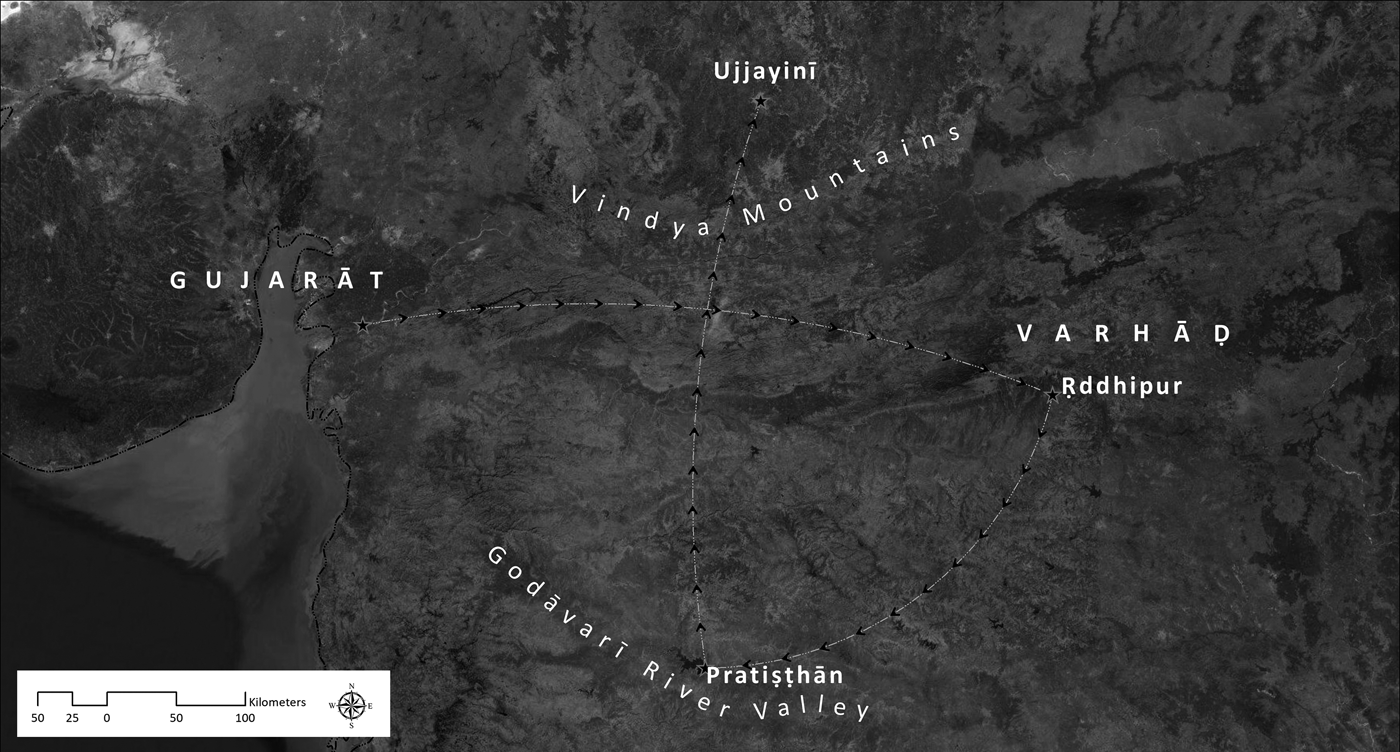
Besides the frequency and precision of the mention of place-names in the text, and besides the geographical framing of its chapters, geography is important to the Līḷācaritra in another way as well: it is basic to the structure and chronology of the text as a whole (see figure 3). Cakradhar came from Gujarat to Maharashtra as a pilgrim. He received a kind of initiation from Śrīprabhu in Ṛddhipur and then moved around, mostly in the Godāvarī valley, for an unspecified number of years.Footnote 17 Eventually Cakradhar settled down, more or less, in Pratiṣṭhān (modern Paiṭhaṇ), staying in a number of different temples in the city, until he left on “the road to the North.” Itinerant cloth merchants traveling between Gujarat and the Godāvarī valley saw him in the Vindhya Mountains; his last known address was Ujjain (Ujjayinī). The end of the Līḷācaritra is thus symmetrical with the beginning: Cakradhar comes south (and east) into Maharashtra from Gujarat, and he leaves Maharashtra by going back north, this time toward—and beyond—Ujjain.
The geographical framework of the Līḷācaritra. Map by Nikhil Shejwalkar. Sources: Esri, DigitalGlobe, GeoEye, Earthstar Geographics, CNES/Airbus DS, USDA, USGS, AeroGRID, IGN, and the GIS User Community.

Within this overall framework, which is both geographical and chronological, the Līḷācaritra is structured in three parts that are differentiated according to the presence or absence of permanent disciples in Cakradhar's company and according to the degree of commitment of his principal disciple, Nāgdev (whom the text often calls Bhaṭobās).Footnote 18 Although this tripartite structure is chronological, within each part the order of the episodes follows the itinerary of Cakradhar's wanderings rather than the months of the calendar or the years of his life.Footnote 19 In general, then, the biography expresses chronology in terms of geography. This is the significance of the cases in which the text takes the trouble to record a disagreement about where a particular episode took place: knowing where it happened is key to knowing when it happened.Footnote 20
Mobility
One reason that geography is so important to the Līḷācaritra is that Cakradhar traveled around a great deal. In fact, not only he but also many other people in the text travel to a large number of places for a wide variety of reasons, and in some cases for no reason at all. As a result, the Līḷācaritra portrays Cakradhar's world as one of nearly constant motion, with people, objects, and messages traveling back and forth and around and around in a complex network of connected places.
For his followers, Cakradhar prescribed a life of constant, solitary, ascetic wandering. “Renounce your attachment to your own land,” he said, in the first sūtra of the section of his collected aphorisms that records his teachings about proper conduct. “Renounce your attachment to your own village. Renounce especially your attachment to your relatives” (Sūtrapāṭh, “Ācār” 1; Feldhaus Reference Feldhaus1983, 199). “Practice constant peregrination,” he commands elsewhere (Sūtrapāṭh, “Ācār Mālikā” 132; Feldhaus Reference Feldhaus1983, 214). Or again, “Throw away your life at the foot of a tree at the end of the land” (Sūtrapāṭh, “Ācār” 26; Feldhaus Reference Feldhaus1983, 200)—closely followed by the caution, “Do not get used to any one tree; do not get used to any one place” (Sūtrapāṭh, “Ācār” 37; Feldhaus Reference Feldhaus1983, 200). Cakradhar himself practiced this kind of itinerancy during the early part of his career as a holy man, the part of his life sketched in the “Ekāṅka” section of the Līḷācaritra. Chapter 8 of that section describes the extreme indifference with which he set out on his career as a wandering ascetic:
Ekāṅka 8. He accepts a state of extreme detachment.
The Gosāvī accepted a state of dispassion. He was not inclined to walk along the road. His matted hair got caught in thorns. The wind would unravel it, or someone would come along and unravel it, and then the Gosāvī would move on. Thorns would pierce his body and scratch it. Drops of blood would appear. They would look naturally beautiful, like rubies on pure gold.
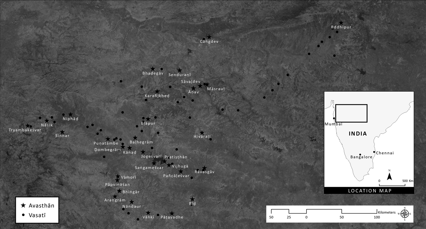
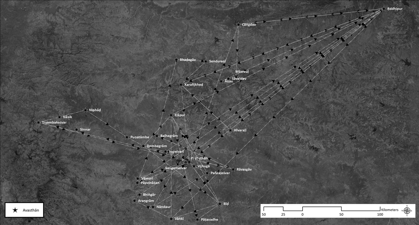
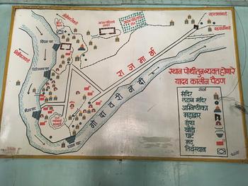
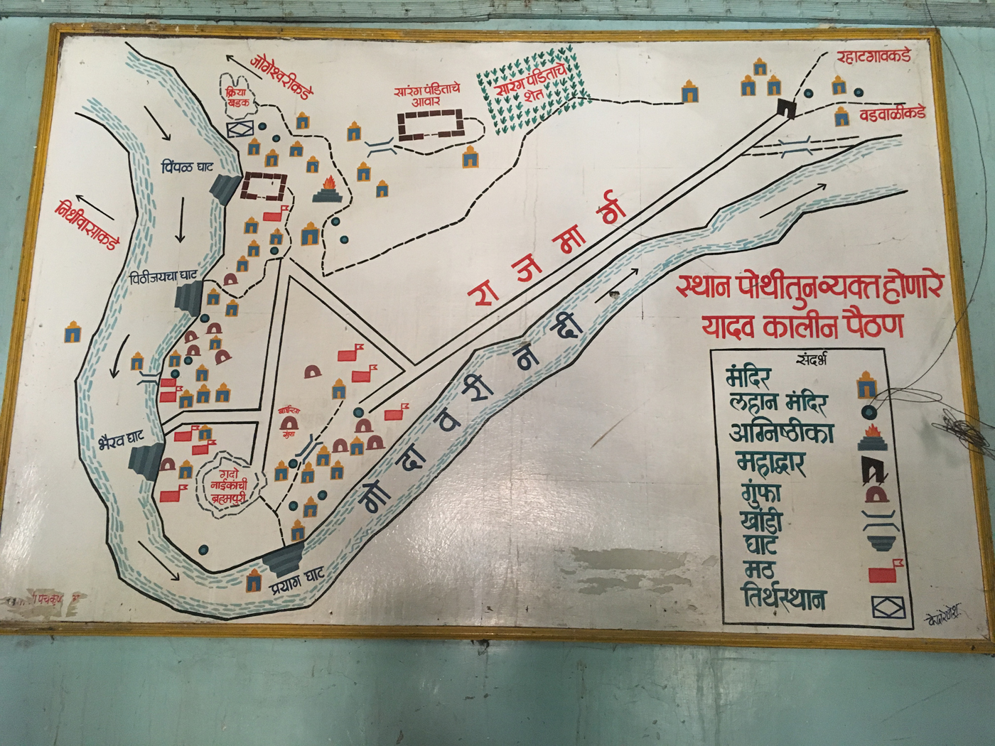
In the two longer and later sections of the Līḷācaritra (“Pūrvārdha” and “Uttarārdha”), Cakradhar continues to wander, but he no longer wanders alone. In these sections of the text, the sections whose episodes were witnessed directly by his disciples, Cakradhar moves with them from place to place, mostly in the Godāvarī valley. His stays are never very long, and they are set in a large number of different places. Figure 4 indicates the principal places where Cakradhar stayed in just the “Pūrvārdha” section of the Līḷācaritra. It distinguishes, as the text does, between places where he stayed overnight (vasatī places); those where he stayed for a longer period, a few days or weeks or even a couple of months (avasthān places); and those where he stopped but did not stay overnight (sthāns).Footnote 21 Figure 5 is meant to provide a sense of the complexity of Cakradhar's travels during the “Pūrvārdha” period: it indicates the order in which he went to the major, avasthān, places mentioned in the text.Footnote 22 In the last half of “Uttarārdha,” Cakradhar stays primarily in Pratiṣṭhān (a place now called Paiṭhaṇ), but still he keeps moving around, living in turn in more than a dozen different temples in that town. Figure 6 is a scholar's reconstruction of the geography of Pratiṣṭhān in Cakradhar's time.
Places visited by Cakradhar in “Pūrvārdha.” Map by Nikhil Shejwalkar. Sources: Esri, DigitalGlobe, GeoEye, Earthstar Geographics, CNES/Airbus DS, USDA, USGS, AeroGRID, IGN, and the GIS User Community.

Route taken by Cakradhar in “Pūrvārdha.” Map by Nikhil Shejwalkar. Sources: Esri, DigitalGlobe, GeoEye, Earthstar Geographics, CNES/Airbus DS, USDA, USGS, AeroGRID, IGN, and the GIS User Community.

Map of Pratiṣṭhān in the time of Cakradhar, on display in the Bāïsā Gumphā temple in Paiṭhaṇ. Much of the area on this map is now under the water behind the Jayakwadi Dam. Map by Dr. Arunchandra Pathak, photograph by Anne Feldhaus. Printed with the permission of Dr. Pathak.
Wherever Cakradhar was staying, he seems to have followed the daily practice of going out for a walk. The text uses a term for this, viharaṇ, that I think can best be translated as “wandering around aimlessly.” Much of Cakradhar's moving from one place where he stayed overnight or longer to another appears also to have been aimless, on a larger scale. In at least some episodes, he seems to have had an itinerary in mind, as he is able to tell a disciple where they can meet again (for example, E61, U235). More often, though, Cakradhar's decisions about where to go appear to have been spontaneous. A good example is found in P352, when he accepts an invitation from a man who happens to come by while Cakradhar is sitting under a tree:
Pūrvārdha 352. He meets Vāyanāyak along the road.
Then, along the road, he sat for a while at the foot of a certain pipal tree. Bāïse washed his feet. The Gosāvī had rinsed his mouth and was chewing pan when Vāyanāyak came along. He was on his way to Rāvasgāv along with his family, for the eighth-month-of-pregnancy rite for [his daughter] Kāmāïse. They were traveling there in a large cart. He was checking on his fields as they went along.
He saw the Gosāvī sitting at the foot of the pipal tree. They greeted each other. Vāyanāyak prostrated himself. He touched the holy feet. Then he said, “What is going on, Lord? Where is the Gosāvī going?”
The Omniscient one said, “I am going to the ascetic grove … at Nimbgāv.”
Then Vāyanāyak made a request: “Rāvasgāv is nice, Lord. There are two temple courtyards there. There is a fine temple of Siddhanāth. There is a temple of Rāmnāth.”
The Omniscient one said …, “I have seen that [place] before.”
Then Vāyanāyak invited him again: “Lord, please come to Rāvasgāv. Please give darśan to my family.”Footnote 23
Then the Gosāvī accepted the invitation.…
In some episodes, Cakradhar and his disciples disagree about when to leave a place (for example, P344), where to go next (for example, P204, P227, U275), or what route to take (for example, U258). Usually Cakradhar wins these arguments. On some occasions, though, he is willing to adjust his plans in order to give a devotee a chance to spend time with him. A good example of this is narrated in U210:Footnote 24
Uttarārdha 210. When he is about to leave, he asks Dādos about giving him days to be with him.
After the Gosāvī’s morning worship service was over, he put on a cloak and a cap. Then the Gosāvī said to Dādos, “O Mahātmā, I am inclined now to move to another village. But you have just arrived here, so where should I give you your days to spend with me?”
“Lord, if the Gosāvī is leaving, I will come along with him. Then the Gosāvī can give me time with him wherever he is inclined to be.”
Then the Gosāvī went to Rāñjangāv.
Moreover, at least once when Cakradhar changes his mind about where to go, he leaves a message for a disciple he has promised to meet in one place, telling her that he will be in another:
Uttarārdha 228. He sends Maṇḍaḷīk to invite Sādhe.
Then, on the third day [of his stay in a certain place], after the Gosāvī’s morning worship service was over, the Omniscient one said, “Maṇḍaḷīk, go to invite Sādhe.… I will go to Bhiṅgār. Bring her there.”
“All right, Lord.”
Then Maṇḍaḷīk set out to invite her.
229. When he reaches Araṇyagrām, he leaves a message for Sādhe.
Then he left for Bhiṅgār. At a certain village, there was one road that went to Bhiṅgār and another that went to Ciñcoḍī [and Araṇyagrām]. The Gosāvī stood at the fork in the road.
Then the Omniscient one said, “Why should a person taking this road not stay on this same road?” The Gosāvī decided to go by the road to Araṇyagrām. The Gosāvī said to Bhaṭobās [also called Nāgdev or “Monkey”], “Monkey, leave a message for Sādhe here in this village.”
“All right, Lord.” Bhaṭobās went up to a man who was seated on a platform at the foot of a tree. Then Bhaṭobās said, “Excuse me. Five women of ours and one Mahātmā are coming along this road. Please tell them, ‘Your Gosāvī is not going to Bhiṅgār after all. He went to Araṇyagrām.’”
When Sādhe came up to that place, the man said, “Mother, your Gosāvī is not going to Bhiṅgār after all. He went to Araṇyagrām. He has invited you to come to Araṇyagrām.”
Sādhe said, “My friend, did Pāṭhā come to tell you the message, or was it Nāgdev?”
At that, the man laughed.
“What are you laughing at, my friend? Nāgdev has two eyes. Pāṭhā has one eye. When he was little, he fell out of his cradle. The seat poked him. His eye got put out.”
At that the man laughed even more.
“Why are you laughing, my friend? Don't you have a mother or sisters?”
“Mother, do I know Pāṭhā? And do I know who Nāgdev is? I gave you the message.…”
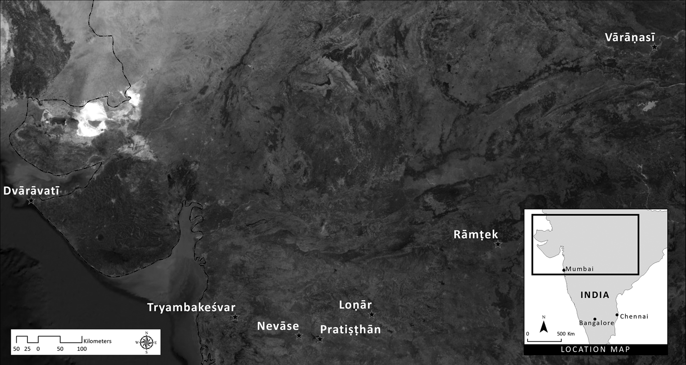
Although Cakradhar's travel is central to the Līḷācaritra, he is by no means the only person in the text who travels. Many others also move around, and they do so for a wide variety of reasons. Several people in the Līḷācaritra go on pilgrimages, generally traveling in largish groups (see figure 7): to Dvārkā;Footnote 25 to Vārāṇasī (U130, U362, U465); to Pratiṣṭhān;Footnote 26 to Loṇār (E71, P274); to Nevāse (U190–91); and to Tryambakeśvar (E72ff., U19, U145). Cakradhar's own travels begin as he sets out from his home in Gujarat to go on pilgrimage to Rāmṭek (E7); “Ekāṅka” ends and “Pūrvārdha” begins with him setting out for the Siṃhastha (Kumbha Melā) festival at Tryambakeśvar (E72–76, P1). The fact that both of his pilgrimages are aborted (P1, E7) does not matter to my point here. They are part of the Līḷācaritra’s evidence of a lively world of travel to holy places.
Places of pilgrimage in the Līḷācaritra. Map by Nikhil Shejwalkar. Sources: Esri, DigitalGlobe, GeoEye, Earthstar Geographics, CNES/Airbus DS, USDA, USGS, AeroGRID, IGN, and the GIS User Community.

Besides going on pilgrimage, people travel for all kinds of other reasons as well. Cakradhar's disciples make trips to nearby villages or market towns for shopping or begging (for example, in U111), and people travel long distances to deliver invitations and other messages. Soldiers set out on military expeditions (E54, P114); cloth merchants travel back and forth between the Godāvarī valley and Gujarat (as we have seen); and horse traders move from village to village selling horses (E16). Women travel from their marital home to their parental home to give birth, and we learned earlier about a father who went to his daughter's marital home for her pregnancy rite (P352). People go to the capital, Devgirī, to deal with government officials, and government officials—sometimes even the king—leave the capital on official or personal business.
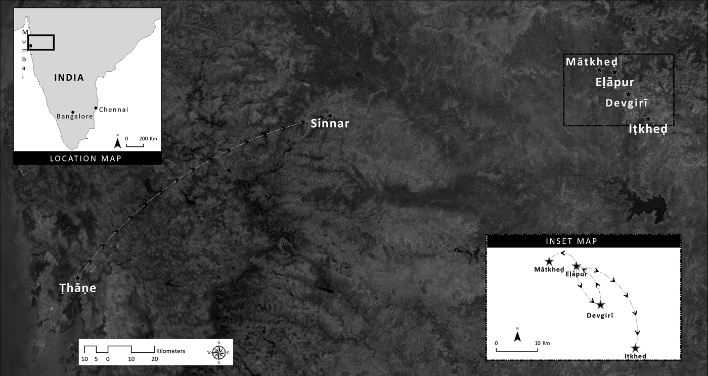
In a fascinating series of chapters, the Līḷācaritra tells of futile attempts by Mahādev, the Yādava king who ruled from 1260 to 1270 (Altekar [1960] Reference Altekar and Yazdani1982, 2:545), to meet Cakradhar. Noticing an epidemic of absenteeism among his courtiers, the king asks where they are all going. Informed that they are going to see Cakradhar, who is staying in the nearby caves at Eḷāpur (Verūḷ, Ellora), the king decides to go there and see for himself. When Cakradhar hears that the king is on his way from Devgirī to find him, he has his disciples pack up and move on swiftly to another place (see figure 8):Footnote 27
Pūrvārdha 104. He agrees to let the king come for darśan.
All the royal servants were coming from the capital for darśan of the Gosāvī. When King Mahādev reached the assembly hall, not a single member of the assembly was there. Then King Mahādev became angry and asked, “Hey! No one seems to have reported for duty. Where do all of you go?”
They said, “If you promise us immunity, we will tell you.”
“Tell me.”
“We go for darśan of the holy man who is at Eḷāpur.”
“What is his name?”
“His name is Śrī Cāṅgdev Rāüḷ Gosāvī.”Footnote 28
With that, the king felt a powerful attraction. “So will you arrange for me to have his darśan?”
“All right.”
Pālhā Ḍāṅgiyā came to say, “Lord, the king is coming for darśan of the Gosāvī.”
The Gosāvī agreed to it.
105. And the king comes.
One day the king got ready. He set out to have darśan of the Gosāvī. And the royal elephant fell down (Or: died).Footnote 29 Because that bad omen occurred, the king turned back.…
Pālhā Ḍāṅgiyā came. He said, “Lord, the king was on his way here when the elephant fell down. So the king turned back.”
Another day the king set out again. That time it rained, so he turned back.
The third time, the king set out with determination. The Omniscient one said, “My woman, Mahādev is an honorable person. He will come for my darśan. He will hand over the kingdom to me. He himself will become my servant.”
Bāïse said, “Is that so, Bābā?”
The Omniscient one said, “Then, my children, you will have nowhere to go.” (Or, Hirāïsā: “Then, my children, you will be set aside.”)Footnote 30
Bāïse said, “Oh, no, Bābā!”
The Omniscient one said, “I will prevent that day from coming. You make the preparations for us to leave.”
Bāïse made all the preparations. The Gosāvī set out.
106. And the news reaches them.
(Paraśarāmbās: He stayed overnight in Mātkheḍ.) (Rāmeśvarbās: He stayed overnight in Itkheḍ.) The Gosāvī was seated there. Bāïse went to fill a water pot. The women who sold dairy products had come back early from selling their yoghurt and milk and ghee. The women at the place for getting water began to ask, “Why have you come back so early today? Most days you come back late from your daily trip to the capital.”
They said, “The king came to Eḷāpur for darśan of a holy man. We sold our yoghurt and milk right there, so we came back early.”
Bāïse heard that. She told the Gosāvī, “Bābā, the women at the place for getting water were talking.” She told him what had happened. “What Bābā said came true.”
The Omniscient one said, “My woman, I told you that I would prevent that day from coming.”
King Mahādev pursues Cakradhar. Map by Nikhil Shejwalkar. Sources: Esri, DigitalGlobe, GeoEye, Earthstar Geographics, CNES/Airbus DS, USDA, USGS, AeroGRID, IGN, and the GIS User Community.

Later, as the king is returning from a military campaign on the west coast, he sends a scout to find Cakradhar, who is now staying in yet another place, one that lies close to the king's route from the coast back to the capital. This time Cakradhar eludes detection by disguising himself as a Gujarati pastoralist and speaking to the king's scout in Gujarati:
114. He conceals his own name.
King Mahādev had gone to Ṭhāṇe on a military campaign. He came to Sinnar. He said, “This is a beautiful town. Maybe the Gosāvī is here.” So he sent Pālhā Ḍāṅgiyā to look. He looked at all the other temples, and then came to the Bhīlmaḍh. Saying, “How could he be here? This is a small temple,” he stayed outside. He sent a man in to take a look.
After the afternoon worship service was over, the Gosāvī ate his meal. He rinsed his mouth, he chewed pan, he went to sleep, and he woke up. The Gosāvī was standing next to the sculpted central part of a pillar, wrapped in a blanket from Saurāṣṭra.
The man asked, “Is Śrī Cāṅgdev Rāüḷ Gosāvī here?”
The Omniscient one said, “Mother, he isn't here. And he isn't there.…Footnote 31 (Hirāïsā: “I don't know about Cāṅgdev Rāül. I don't know about Bāgdev Rāül. There was an old woman here. She has gone into the village to beg for alms.”) (Or: There aren't any Mahātmās or Bahātmās. I am right here.”)Footnote 32
Then the man left.
In fact, much of the travel in the Līḷācaritra consists of people coming to meet Cakradhar, either for the first time or on repeat visits. Usually they have more success than the king did in finding him. In several episodes, disciples who have been moving around with Cakradhar go away and come back to whatever place he has reached by the time they return. Some disciples, even some who have taken initiation as ascetic renouncers, return to their home villages to visit their families and provide for their welfare (for example, P90, P348). Other disciples go away on pilgrimage for a while. Still others travel wherever Cakradhar sends them, whether to deliver a message; to find a place to stay in the next village (for example, P138, P276, P282, and U214); to pick up belongings that have been left behind (for example, P437); to dispose of the body of a dead fellow ascetic (U260–61); or to serve Cakradhar's guru, Śrīprabhu, in Ṛddhipur (P274, P343, U2, U292, U322; cf. P339). Indeed, much of the coming and going in the text is of disciples whom Cakradhar has sent to Ṛddhipur or summoned back from there. These trips provide some of the biggest oscillations in the text, as most of the places where Cakradhar stayed with his disciples were in the Godāvarī valley, while Ṛddhipur lies far to the northeast, in Varhāḍ, a different subregion of the Marathi-language world (see Māṭe Reference Māṭe1975).Footnote 33
The Bonds of Love
If the intention behind the ascetic peregrination that Cakradhar practiced, and that he enjoined for his disciples as well, was to avoid attachment—to one's land, to one's village, even to one particular tree at the “end of the land”—much of the other mobility in the Līḷācaritra is based on people's attraction and eventual attachment to Cakradhar himself. Like the Yādava king, many others who are not, or not yet, Cakradhar's disciples come to see him (that is, they come for his darśan). And a common theme in the episodes in which Cakradhar sends his disciples off somewhere is their strong desire to return and be with him. Early in the Līḷācaritra (E14), a fervent disciple whom Cakradhar has sent to stay in the next village comes to the edge of that village every day to inquire about Cakradhar's welfare. When someone mischievously tells the man that Cakradhar has died, the disciple himself drops dead from grief. Much later in the Līḷācaritra, when Cakradhar sends away all the disciples who are with him, he finds himself wondering why they are not as devoted as the dog, Ḍāṅgarā or Ḍāṅgareś, who similarly dies from the agony of separation:
Uttarārdha 310. Ḍāṅgarā dies.
One day the Gosāvī … said to his devotees, “Hey, why are you all here? You have no idea how to please me. When you are here, everything that happens is bad. All of you, get out of here.”
“All right, Lord.” Then they all left.
Ḍāṅgareś was sitting there. The Omniscient one said, “Ḍāṅgarā, you go away too.” He got up, he circumambulated the holy feet, and he set out. There was a stream that flowed into the river south of the Kedār temple. He laid down his body there.
Then, when it was time for the afternoon worship service, all the devotees came back. They prostrated themselves to the Gosāvī. They touched his holy feet. Then the Omniscient one said, “Hey, you have all come back. Why has Ḍāṅgareś not come back?”
“He must have gone somewhere to fill his stomach, Lord.”
The Omniscient one said, “That's not so. Go. Look for him.”
So all the devotees, with Bhaṭobās in the lead, went to search for the dog. Bhaṭobās saw him from a distance. Then everyone came to tell [the Gosāvī], “Lord, Ḍāṅgareś has laid down his body.”
The Gosāvī went there. He sat down near him. The Gosāvī said, “Ḍāṅgarā” and touched him with his holy hand. Then he had Bhaṭobās dig a grave. He had them bury him.
The Omniscient one said, “This dog is better than you. Being separated from me made him completely unable to stay alive.”
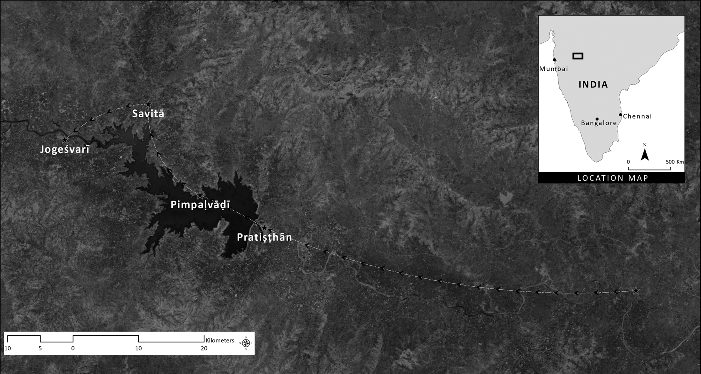
Some of the most intricate travel stories in the text are those in which a disciple who has been separated from Cakradhar searches for him, going to place after place in an effort to catch up with him as he moves around. The following episode provides a sense of the lengths to which some people went to find their constantly moving guru. Figure 9 traces the route along which the disciples in this chapter pursued Cakradhar:Footnote 34
Pūrvārdha 433. He meets Umāï and Avaḍaḷ.
Umāïse and Avaḍaḷbhaṭ set out for darśan of the Gosāvī.… They were traveling one stop behind him. They reached Pratiṣṭhān. There they met Lakhubāïse. They asked her, “Where is the Gosāvī living?”
She said, “Pimpaḷvāḍī. The Gosāvī left here yesterday. I went to see him off.”
Immediately they came to Pimpaḷvāḍī. They asked Mahādev Pāṭhak. He said, “The Gosāvī ate his meal in the babul grove. He slept in the Brahmanāth temple. Then the Gosāvī went to Savitā. I just got back from seeing him off.”
They had spent that whole day traveling, and they could not catch up with him. So they stayed in Pimpaḷvāḍī. Early the next morning they came to Savitā. They asked the priest of the Nāgnāth temple there.… The priest said, “The Gosāvī spent the night here. He left early in the morning for Jogeśvarī. He rinsed his mouth here.…”
Umāïse looked down. She saw pan that had been spat out. Umāïse picked up the bits of betel nut and took them as prasād.Footnote 35 … They smelled good and were extremely fragrant.…
Then immediately they came to Jogeśvarī. The devotees were cleaning the cell. The Gosāvī was seated on the verandah of the temple, facing north. Umāïse and Avaḍaḷbhaṭ had darśan there. They prostrated themselves. They touched the holy feet. They sat down.
Then Umāïse told the Gosāvī everything that had happened. “Lord, I saw bits of betel nut that were very beautiful and extremely fragrant. I said, ‘If these bits of betel nut are like this, they must be our Gosāvī’s.’”
The Gosāvī agreed.
Umāïse and Avaḍaḷbhaṭ search for Cakradhar. Map by Nikhil Shejwalkar. Sources: Esri, DigitalGlobe, GeoEye, Earthstar Geographics, CNES/Airbus DS, USDA, USGS, AeroGRID, IGN, and the GIS User Community.

Umāïse's reverence for the bits of betel nut that had emerged from Cakradhar's mouth adumbrates the veneration for relics that his Mahānubhāv followers developed in the years after his departure. Her intense desire to be with Cakradhar, to be in his sannidhān, his presence, was partially assuaged by holding, and even ingesting, something that had been inside his mouth. Similarly, the inspiration to compose the Līḷācaritra appears to have emerged from a desire to hold onto Cakradhar by recording in detail everything he had said and done. The pilgrimage tradition that grew up concurrently with the veneration of relics and the composition of the Līḷācaritra is another powerful way to remain close to Cakradhar, by going to the places where he had gone and remembering the things that he had said and done at the places.
Cakradhar himself enjoined his followers to “remember” him—that is, to practice smaraṇ, recollection, of him—during periods of separation while he was still alive. In Līḷācaritra P90, when Cakradhar's disciple Cāṅgdevbhaṭ is summoned to his home village to visit his mother, Cakradhar tells him, “Baṭikā, think of me ten or twenty times a day. If not ten or twenty times, then think of me five or seven times. If not five or seven times, then think of me two or four times. If not two or four times, then at least think of me once or twice. If not once or twice, then think of me at least once. But do not let a day go to waste.” In another episode, Cakradhar also explicitly commands his disciples to visit places where he himself has stayed. He chides Nāgdev (Bhaṭobās) for having passed near but not gone into one such place:
Uttarārdha 52. He sends Bhat to Rākṣasbhuvan.
One day the Gosāvī sent Bhaṭobās to Rākṣasbhuvan on an errand. It is not known what the errand was. He completed the task and came back by way of Pañcāḷeśvar.
He prostrated himself. He touched the holy feet.
The Gosāvī asked, “Did you come back by way of Pañcāḷeśvar?”
“Yes, Lord.”
The Omniscient one said, “Did you go into Pañcāḷeśvar?”
“No, Lord.”
The Omniscient one said, “You should go to the places where I have been!”
It was after Cakradhar had left, when his disciples’ separation from him became extremely prolonged (for centuries, as it has turned out), that his “deputy,” Nāgdev (Bhaṭobās), made explicit the connection between smaraṇ of Cakradhar and visits to places where he had been. Nāgdev advised his fellow disciples, “Go to holy places (tīrthas) and recollect the deeds (līḷās) that were done at them. That is the way one practices recollection (smaraṇ) there” (Smṛtisthaḷ 39; Feldhaus and Tuḷpuḷe Reference Feldhaus and Tuḷpuḷe1992, 79).
Conclusion
In the centuries since the Līḷācaritra was written, the tradition of Mahānubhāv pilgrimage has spawned a number of additional premodern texts and modern guidebooks,Footnote 36 as well as architectural embellishments, websites,Footnote 37 YouTube videos,Footnote 38 and mobile phone apps.Footnote 39 It is in this pilgrimage tradition, I believe, that we find a deeper explanation of the importance of geography to the Līḷācaritra. Besides the fact that Cakradhar was extremely mobile, the Līḷācaritra was created and preserved by and for a community of people who were themselves pilgrims. They needed to know exactly where Cakradhar had done the things he did so that they could visit those places themselves—and thereby soothe the pain they felt at his absence. In other words, geography is central to the Līḷācaritra because visiting places where Cakradhar went is a way of being as nearly as possible in his presence, his sannidhān, given the harsh fact of his asannidhān, his absence.
Sannidhān, then, is a (socio-)geographical value that provides the motivation for a pilgrimage tradition that thrives today. The assumption of that tradition is that places are capable of embodying their own pasts and of bringing one closer to people who once lived in or visited the places. This assumption is one that I believe is widely shared around the world; it has significant religious-ritual consequences in a number of traditions. Moreover, as geographers like Doreen Massey (Reference Massey1995) have shown—or as anyone who visits Jerusalem, for example, will realize—the assumption that places can embody their own pasts has powerful political and social consequences as well.
The connection of places with their pasts also tells us, I think, something important about biography in general. When I think back on my own life, it falls into periods that I identify by the places where I have lived, studied, and worked. Many academics’ CVs are characterized by a similar periodization. On a personal level, whereas some people remember what year something happened by what age they were or what age their children were at the time, I tend to remember my life and the history of my times in terms of which years I have spent in India or other countries. Those readers whose work similarly takes them back and forth across the globe may think of their own lives in these sorts of terms as well. Among historians who write biographies, I would be interested to learn how many end up periodizing or framing the biographies in terms of geography. Could it be that not just Cakradhar's, but most biographies are geographies?
What, then, do we learn from the thirteenth-century Mahānubhāvs who compiled Cakradhar's highly geographical biography? We learn the importance of sannidhān, of being in the physical presence of someone who matters greatly to us. We learn the importance of place to the remembrance of those who have gone away, and, conversely, we learn the importance of history and biography to a sense of place. As scholars, we learn the significance of geography for biography, while, at the same time, as people reflecting on our own lives, we learn to attend to the central role that geography plays in the ways we think about our development and formation.
Finally, the Līḷācaritra reminds us that presence is something that we all long for. This is the case even in an age of technologies meant to mitigate our geographical separation. Mobile phones, landlines, Skype, FaceTime, WhatsApp, WeChat, LINE, Zoom, and online learning are all fine as substitutes, twenty-first-century equivalents of relics, pilgrimages, and detailed biographies. But what belies the view that substitutes can be as effectual as the real sannidhān is the number of airplanes that we scholars take to get to a conference, spending time and money and creating large amounts of carbon dioxide in order to be together on a particular day, in a particular place, in one another's presence.
Acknowledgments
The many colleagues and friends who provided helpful and thought-provoking comments on earlier drafts of this essay include Nina Berman, Vinayak Chaturvedi, Richard Eaton, Tracy Fessenden, Irina Glushkova, Alexander Henn, Jon Keune, Stephen MacKinnon, Christian Novetzke, James Rush, Yasmin Saikia, Lee Schlesinger, Juliane Schober, and Shahla Talebi, as well as other participants in the 18th International Conference on Maharashtra at the University of Texas at Austin (January 2019) and in a session on the paper at the Center for Asian Research at Arizona State University (February 2019).