Introduction and historical background
In 1909 a pioneer in studies of Arctic navigation, Admiral Aleksandr Kolchak, wrote in Russian of ‘an area that may be schematically. . . in the form of an elongated ellipse whose major axis corresponds approximately to a line connection Crown Prince Rudolf Island (Franz Josef land) with Cape Barrow (north coast of Alaska) and whose minor axis corresponds to a line drawn from Bennett Island to Cape Alfred Ernest (west coast of Grant Land, or Garfield Coast). The point of intersection of these lines lies approximately in longitude 180° and latitude 84°N. The area defined by this ellipse enclosed the region permanently covered with the ice fields of the Arctic pack and inaccessible to navigation.’
This remained relatively unknown until translated into English in 1928 (Kolchak Reference Kolchak and Joerg1909). A footnote in the published translation indicates that this was an earlier formulation of the concept which Vilhálmur Stefansson later propounded independently as the ‘pole of relative inaccessibility’. In 1909, Kolchak was unaware of the existence of the Arctic archipelago of Severnaya Zemlya [Northern Land], the last major land area on Earth to be discovered. The discovery of part of this archipelago was in 1913 (Starokadomskiy Reference Starokadomskiy and Barr1976) but its full extent was unknown until 1932 (Barr Reference Barr1975). The resulting maps extended to the northernmost land of the archipelago, Mys Molotov [Molotov Cape] (later renamed Mys Arkticheskiy [Arctic Cape]), which would have influenced the position of Kolchak's ellipse.
In 1920 a variation of such a concept was developed by Stefansson (Reference Stefansson1920). This was reprinted in 1921 (Stefansson Reference Stefansson1921) with the addition of some further relevant thoughts. Stefansson's definition was more practical than theoretical involving the possibility of reaching a pole of inaccessibility by various methods then in use for Arctic travel (first a ‘Zone of Approach by Ship’ and within this a ‘Zone of Man-Dog Travel’ and ultimately a ‘Zone of Comparative Inaccessibility’). It was illustrated by a general map of the Arctic (although still lacking any indication of Severnaya Zemlya) and specified the position as 83° 50′ N, 160° W. He included some speculation and analyses of modes of travel practicable at the time.
Stefansson (Reference Stefansson1920) defined the pole of inaccessibility in a rather particular way, to mean ‘the point within the arctic regions most difficult of access for any explorer who first goes as far as he can by ship and then pushes forward by the use of men and dogs hauling sledges’. More recently, the term has been commonly used to denote the point farthest from a specified coast, either on land or in the sea. The Arctic pole of inaccessibility (API) defined in this sense, appears to have served as a focus for exploration for several decades. The flight northeast from Barrow, in Alaska, made by Sir George Hubert Wilkins in 1927, has appeared in literature, and more recently on several internet sites, as one intended to attain such a pole. It landed on the pack ice at a position of 77° 45´ N, 175°00´W where Wilkins made a preliminary sonic depth measurement of 5625 m, corrected to 5440 m (Wilkins Reference Wilkins1928a). A detailed narrative (Wilkins Reference Wilkins1928b) described the many difficulties of the flight, abandonment of the aircraft, and trek over pack-ice to return, but which provided minimal scientific information. Neither of these publications made any reference to a ‘pole of inaccessibility’ which is curious as Wilkins was a colleague of Stefansson during the ill-fated Karluk expedition of 1913–1918 and they remained in contact (Montgomery Reference Montgomery1948; Thomas Reference Thomas1961). Indeed Wilkins wrote ‘For Vilhjalmar Stefansson's advice and encouragement I am most grateful’ (1928b: x).
The next approach to the pole was in 1928 during the flight of the dirigible Norge from Svalbard to Alaska, during which the geographic North Pole was first indubitably sighted on 12 May. The flight continued towards Alaska when Roald Amundsen referred to the ‘Ice-pole-or, as up to this time was called, the Inaccessible Pole - is the centre of the great ice-covered region and as such, of course, is the most difficult place to reach’ (Amundsen and Ellsworth Reference Amundsen and Ellsworth1928: 121). Interestingly on this occasion Amundsen and Oscar Wisting, who had reached the geographical South Pole together on 14 December 1912, became the first persons to have seen both poles. After passing above the geographical North Pole (incidentally on his 46th birthday) Lincoln Ellsworth, who funded the expedition and who was on board, wrote ‘we came to a hypothetical spot on the map hitherto unseen by man, the so-called Ice Pole. The Ice Pole, at Lat. 88°N, and Long. 157°E, is the geographical centre of the Arctic ice mass, the edges of which are all well explored and known’ (Ellsworth Reference Ellsworth1938: 217).
Shortly after the rescue of some of the survivors from the crash of the airship Italia by the Soviet icebreaker Krassin in 1928, interest in Arctic aviation increased rapidly as Soviet authorities concentrated on the northeast passage (northern sea route). Aerial survey and reconnaissance, particularly of ice conditions, became frequent and several crossings of the Arctic and other long-distance flights were made. Techniques of landing on ice floes, even close to the geographical North Pole, developed as specialisations. Armstrong (Reference Armstrong1958) described three flights in April 1941 departing from the sea ice of Bukta Rodzhersa, [Rogers Bay], Ostrov Wrangela [Wrangell Island], and intending to reach ‘the region of the Pole of Inaccessibility’. These had Yakov Libin as chief scientist and Ivan Cherivichnyy as pilot of an SSR-N-169 aircraft. The flight on 3 April landed at 81° 27′ N, 181° 15′ E, on 13 April at 78° 31′ N, 176° 46′ E, and on 23 April at 79° 56′ N, 179° 55′ W. Each stayed for a few days surveying the position and drift of the pack ice while conducting physical research and making biological collections. The flights are indicated in the Atlas Arktiki (Treshnikov Reference Treshnikov1985) and a series of scientific results was published (Vize Reference Vize1956). The flight of Sedov-5, in 1950 from Mys Schmidt [Smith Cape] followed the 166° 30′ W meridian from 76° 40′ N to 90° N thus it was also in the vicinity of the pole of inaccessibility. Many subsequent flights came near the position while establishing, supplying and evacuating drift stations, engaged in ice reconnaissance, and other purposes.
Subsequently Soviet Union and Russian aviators maintained a comprehensive programme of landings on the Arctic Ocean pack ice. Some of these went to the drift stations but most landed, mainly in spring when conditions are most favourable, for short periods elsewhere. These, opportunistically, progressively accumulated knowledge of bathymetry and other aspects of the ocean. Many of the data were regarded as of military significance owing to their value for submarine navigation, consequently there is little published information available. In 2000 a summary of landings appeared which included details of aircraft and personnel involved and a series of small-scale annual maps (Konstantinov and Grachev Reference Konstantinov and Grachev2000). From these it may be determined that in 1973, during programme Sever 25, and in 1977, Sever 29, aircraft landed relatively close to the actual pole of inaccessibility. The precise coordinates of the landings, and take-off after drifting, are not given. The published maps show no other flights landed in that vicinity although many would have flown over, or very close to, the position.
Beginning in 1937, the Soviet Union deployed 31 Arctic drift stations, and subsequently Russia has deployed several more. Inevitably a few of these drifted close to the vicinity of the pole of inaccessibility and two came very close to the geographical North Pole. Their courses are indicated in several small-scale Arctic Ocean charts (Romanov and others Reference Romanov, Konstantinov and Kornilov1997; Treshnikov Reference Treshnikov1985). From these it may be seen that in the proximity of the actual pole of innaccessibility the course of drift stations tends to become irregular with many changes in direction in comparatively short times. This is probably an influence of the edge of the Beaufort Gyre. Thus CP 4 (in 1955), 8 (1959), 20 and 22 (1972), 26 (1986), and 30 (1991) have followed convoluted courses in its vicinity. During the period of operation of a drift station several flights land nearby and others drop supplies and equipment.
The United States nuclear submarine, Nautilus, commanded by William Anderson, passed near the putative pole of inaccessibility in 1958 during a submerged journey from off the Alaskan coast, on a bearing of 155° N. The master reported, on 2 August 1958, that the submarine had the pole of inaccessibility abeam, ‘But who cared? We were safe, warm, and comfortable in our home beneath the sea’ (Anderson Reference Anderson1959: 156).
One of the way points during the British Trans-Arctic Expedition of 1968–1969, led by Wally Herbert was ‘to be in the vicinity of the Pole of Relative Inaccessibility by Midsummer's Day’ (Herbert Reference Herbert1969: 111). An injury to one of the four men caused delays and a period in a camp, termed ‘Meltville’, drifting from 82° 27′ N, 163° 30′ W until ice conditions improved for travel to continue north. Several secondary accounts of the expedition report that it reached the pole in question.
The location of the pole, as well as its definition, have resulted in it being the last notable place in the Arctic Ocean attained by a ship. The Russian nuclear powered icebreaker, Yamal, made a voyage from Murmansk to the North Pole in 1996 with passengers aboard. The destination, after a transit of the Arctic Ocean, was Barrow in Alaska. Ice conditions were good after the North Pole, thus, on 1 August the icebreaker reached the position and remained for some eight hours. The position was deemed as 84° 03′ N, 174° 51′ W. Signals were exchanged with the Murmansk Shipping Company which acknowledged the significance of the attainment (Headland Reference Headland, Lück, Maher and Stewart2010). There is no record of any of the icebreakers navigating in the central Arctic Ocean reaching the actual pole of inaccessibility.
It seems clear that the concept of the API has provided a focus for exploration since the concept was first described almost a century ago, and it continues to do so today. In the first decade of the present century several adventurers have expressed interest in it and, at a high price, offered to lead visitors to it. In this paper we concern ourselves with the location of the API. As is apparent from the previous section, this position has come to be widely accepted as being near 84° 03′ N, 174° 51′ W (Wikipedia 2013) although we have been unable to identify who first calculated this, or on what basis. We refer to this position as the ‘putative API’.
Defining the position of the API
We can think about the mathematics of the API in several ways. To see the principles involved, it is simpler to ignore the Earth's curvature. In this case, the API is defined as the centre of the largest circle that can be drawn within the Arctic Ocean without any part of the circle crossing onto land. Since a circle of given centre and radius can be defined, on a fixed plane, by its passing through three points, it follows that there must be precisely three points on the coasts which lie at the minimum distance from the API. This can be illustrated by considering the following heuristic procedure for locating the API. First, we choose some arbitrary point A in the Arctic Ocean, and draw progressively larger circles centred on this point until the circle touches land at some point B. The circle is now further enlarged by moving the centre away from A along the direction BA, while continuing to maintain B as a point of contact. Eventually the circle will also touch land at some new point C. The circle can still be enlarged, by moving its centre along the bisectrix BC, still maintaining B and C as contact points, until it touches land at a third point D. At that stage, the circle cannot be enlarged, and its centre defines an API. If the starting point A is chosen incautiously, for example in a bay or confined sea, it may be that another API, with an even larger radius, could be found.
The problem of locating the API is thus equivalent to the problem of finding the three contact points. Alternatively, we can define, for every point on the ocean surface, a function that is equal to the distance from that point to the nearest land. The API then corresponds to the location of the maximum value of this function. In fact this function does not in general have just a single maximum. This is obvious if we consider the global ocean as a whole: there are local maxima corresponding to the poles of inaccesibility of the various bays and seas that compose it, as well as an absolute maximum corresponding to the farthest point from land anywhere on the Earth's surface (this is ‘Point Nemo’ in the Pacific Ocean). Thus, the precise choice of region may control the location of the pole. Fortunately, this does not introduce any difficulty into the calculation of the API.
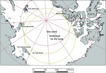
It does not require much effort to see that the traditional API is incorrect (see Fig. 1). The land closest to this point is a small island Ostrov Genriyetta [Henrietta Island] around 910 km distant from it, but the next nearest point is located at a distance of around 1060 km, on Ellesmere Island whereas it should, of course, be equidistant. The traditional position is described as being 1094 km (680 statute miles) from the northernmost coast of Ellesmere Island and Zemlya Frantsa-Iosifa [Franz Josef Land] north of European Russia. This is a statement calculated to arouse some doubt, since no third point is mentioned. We checked this position using satellite image data from the Moderate Resolution Spectroradiometer (MODIS) sensor about NASA's Terra satellite, which is geolocated to an accuracy of about 50 metres (Wolfe and others Reference Wolfe, Nishihama, Fleig, Kuyper, Roy, Storey and Patt2002), and the GSHHS coastline for the northern hemisphere (this is described below). Using the MODIS imagery we could independently locate coastline pixels, and thereby check the accuracy of the coast to within a hundred metres. In most areas we found the GSHHS coastline to be accurate at this degree, but there are some areas of mislocation in the high Arctic.
Position of the API calculated in this work, both including and excluding Ostrova De Longa, and the traditional position still widely assumed to be correct. The dash-dot line connects points 1008 km from the actual API, while the dotted line connects points 1118 km from the API calculated ignoring Ostrove De Longa. Azimuthal equidistant projection (WGS84 ellipsoid) centred at 85° 48′ N, 176° 09′ E (that is the newly calculated API).

Using these datasets, we find that the traditional API is actually 1035 km (591 nautical miles) from the northern coast of Ellesmere Island, at a point on the cape immediately west of Disraeli Fiord. The distance from the traditional API to the closest part of Zemlya Frantsa-Iosifa is 1354 km (731 nautical miles), considerably too far away to be one of the reference points used. (The islands within Zemlya Frantsa-Iosifa closest to the traditional position are Ostrov Rudol'fa [Rudolf Island] and Ostrova Belaya Zemlya [White Land Islands].) Instead, the second point in the putative definition was probably the tip of Severnaya Zemlya, Mys Arkticheskiy [Arctic Cape], 1140 km from the assumed API. However, it is unclear if Mys Arkticheskiy was known in the 1920s. The third point must have been in Ostrova Novosibirskiye [New Siberian Islands]. The north cape of Ostrov Kotel'nyy [Kettle Island], Mys Anesiy, the largest in the archipelago, is 1130 km (610 nautical miles) distant from the traditional API.
In the next two sections we calculate the position of the API using modern methods and data, and then consider the possible reasons for the erroneous location.
Modern determination
Historically, the location of the API would have to be determined geometrically, using map and compasses. This is a rather laborious process and it has significant scope for error through the trial-and-error method that needs to be adopted. Another potential difficulty is caused by the projection of the map. On a map, the locus of points that are equidistant from a given location P will not, in general, be a circle centred on P. The exception to this principle occurs when the map projection is of the azimuthal type, centred on P. Such maps are not commonly available except in the case where P coincides with the geographical North Pole. In the case of an azimuthal map projection centred on the North Pole, the departure from circularity amounts to a few kilometres if P is located 5° from the pole and the distance of the points from P is 1000 km. Of the common azimuthal projections, the stereographic projection gives the greatest distortion (around 4 km) while the azimuthal equidistant projection gives the least (around 1 km).
Modern technology, in the form of computers and digital maps, offers scope for more systematic and precise determination of their location (Garcia-Castellanos and Lombardo Reference Garcia-Castellanos and Lombardo2007). We use the Global Self-Consistent, Hierarchical, High-resolution Geography (GSHHG) database (Wessel and Smith Reference Wessel and Smith2013). This combines data on shorelines from the World Vector Shorelines database and on lakes from the CIA World Databank II. Both of these are public-domain databases. The coastline data in GSHHG, which are what primarily concern us here, were originally compiled in 1996 (Wessel and Smith Reference Wessel and Smith1996) and are stated to have an accuracy of 500 m, in the sense that 90% of identifiable coastal features are represented within 500 m of their true locations. These data are sampled at intervals of typically around 100 m along the coasts.
We essentially followed the algorithm of Garcia-Castellanos and Lombardo (Reference Garcia-Castellanos and Lombardo2007) to determine the location of the API. This involves defining a region R containing the location of the API, and evaluating the minimum distance to land from each point on a grid that spans the region R. The point for which this minimum distance is greatest, and its location, are calculated. The process is then repeated for a new region R’ having half the area of R and centred on this new location. This process is repeated iteratively until the spacing of the grid points is sufficiently small. Our version of the algorithm was coded in the public domain GNU Octave programming language (Eaton Reference Eaton1998). We used an initial region R approximately 1000 km square, and at each step of the iteration the search region was gridded into 21*21 points. The iteration was stopped when the grid interval reached a value corresponding to a precision of around 100 m.
One difference between our implementation and that of Garcia-Castellanos and Lombardo (Reference Garcia-Castellanos and Lombardo2007) is that we do not assume the Earth to be spherical. Instead we assume that it has the form of the WGS84 ellipsoid. Distance calculations use Kleder's (Reference Kleder1994) implementation of the Vincenty algorithm (Vincenty Reference Vincenty1975).
Results, and comparison with previous position
Following this procedure, we find the location of the API to be at 85.802° (85° 48′) N, 176.149° (176° 09′) E. The distance to the nearest land is 1008 km. The three contact points that define this location are as follows: (1) 83° 07′ N, 77° 13′ W, on the coast of Ellesmere Island near Cape Discovery; (2) 81° 17′ N, 95° 40′ E, at Mys Arkticheskiy at the northern tip of Ostrov Komsomolets in Severnaya Zemlya, and (3) 77° 08′ N, 156° 36′ E, near Mys Danbar at the northern tip of Ostrov Genriyetta of the Ostrova De Longa [De Long Islands]. Fig. 1 shows these locations. Our calculated position is very close to the only other modern determination known to us (Scambos and Haran Reference Scambos and Haran2005). This calculation, which used modern satellite imagery to define coastlines, gave a position of 85.780° N, 176.145° E, approximately 2.5 km from the position calculated in the present paper. The small discrepancy could be accounted for by inaccuracies of the order of a km in the GSHHG coastlines.
This newly calculated position for the API is 214 km from the traditional location, and much closer (449 km as compared to 665 km) to the North Pole. This raises the interesting question of why the traditional position is so wrong. The closest land to the traditional position is Ostrov Genriyetta, at a distance of 910 km. However, there is no other land at the same distance so it is clear that this point cannot in fact be the API. Ostrov Genriyetta is small, just a few kilometres across, so perhaps it was ignored or forgotten about in the original calculation although it has appeared on charts soon after its discovery in 1881 (De Long Reference De Long1883). If so, it would have been likely that all five of the Ostrova De Longa, all of which are small (the largest, Ostrov Bennetta [Bennett Island], has a broadest dimension of around 28 km), would have been omitted.
We recalculated the position of the API having deleted the five Ostrova De Longa from the coastline database. This yielded a position of 82° 49′ N, 172° 35′ W, which is not particularly close (141 km) to the traditional location. If we continue to ignore the presence of these Islands, the traditional API is almost equidistant from Mys Arkticheskiy (1172 km) and the closest point in Ostrova Novosibirskiye, on Ostrov Kotel'nyy (1168 km). This suggests that these points may have been used to define the API. However, the closest point on Ellesmere Island to the traditional API is about 100 km nearer. For consistency with the traditional position, and still ignoring Ostrova De Longa, it would be necessary to redraw the northern coast of Ellesmere Island approximately 100 km south of its true position. However, maps of the late 19th century show the coastline already in its correct location, so it seems unlikely that this was the source of the error.
Discussion
It is clear that the API, as we have defined it here, is nowhere near the position that it is still widely stated to occupy, but is in fact around 200 km from that position (and around 200 km closer to the geographic North Pole). The uncertainty in the position that we have calculated here is of the order of 1 km, based on the stated accuracy of the GSHHG coastline, so we can be confident in identifying the three points on the Arctic coasts that define the position of the API. These are located on Ostrov Genriyetta, Ostrov Komsomolets and Ellesmere Islands. On this matter, too, the commonly stated information is incorrect, since the three defining points are usually stated (Wikipedia 2013) to be on Ellesmere Island, the Ostrova Novosibirskiye and ‘Franz Josef Land’. This is probably a perpetuated misprint, since there cannot possibly be a defining point in Zemlya Frantsa-Iosifa, and it should instead be located on Ostrov Komsomolets.
We have followed common practice and taken a very simple definition of inaccessibility in this paper, based on distance from any land whatsoever. Stefansson's original concept (1920) was somewhat more sophisticated than this, being an attempt to define the point in the Arctic that would be most difficult to reach in a particular manner. It would be interesting, and perhaps meaningful, to return to this idea and calculate other poles of inaccessibility, such as the point that its farthest from any permanent human settlement, or from an airport. For example, using a list of 33 permanent public (that is, not purely military or scientific) settlements in the Arctic leads to a pole of inaccessibility at 85° 22′ N 168° 45 E, 1686 kilometres from Siorapaluk, Tiksi and Barrow. This is actually fairly close (80 km) to the API calculated in this paper. However, we do not suggest that the data on which this calculation has been performed were in any sense systematic.
Conclusions
The API, defined as the point in the Arctic Ocean farthest from land, is located at 85° 48′ N, 176° 09′ E. We believe this position to be accurate to within 2 km, or about one minute of arc. It is 1008 km from the nearest land, on Ostrov Genriyetta in the Ostrova De Longa, at Mys Arkticheskiy on Ostrov Komsomolets, and on Ellesmere Island. This position is over 200 km from the commonly accepted position of the API. The reason for this former persistent error remains unclear.
Acknowledgements
We are grateful to Jim McNeil for drawing this question to our attention.