

Introduction
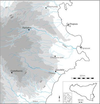
Inhumation in chamber tombs cut into rock was a common form of burial in Sicily from the later fourth millennium bc, or Copper Age (Hayden Reference Hayden2007), into historical times, which has resulted in the survival of numerous prominent cemeteries. They are especially characteristic of the Hyblaean region in the southeast of the island, which comprises a raised limestone plateau traversed by deep river valleys locally called cave [canyons] (Fig. 1). There may be 10,000 or more rock-cut tombs in this area alone, although limited survey data prevent an accurate estimate. Many are clustered in extensive burial grounds surrounding large Late Bronze and Iron Age sites dating from about 1250–600 bc, which are known mainly from the excavations undertaken over a century ago by Paolo Orsi. Despite, or perhaps because of, the great abundance of these tombs, and the fact that the majority had been emptied out before Orsi's time, they are mostly unrecorded.
Locations of main sites mentioned in the text.

The limited information from old publications and the absence of detailed topographical plans showing tomb locations prompted the author to reappraise several sites between the Anapo and Tellaro rivers and to undertake some preliminary survey at Pantalica, which is renowned for c. 4000 chamber tombs of the Late Bronze and Iron Ages (Leighton Reference Leighton2011; Reference Leighton2015). One aim was to examine the role of the tombs in the configuration of major settlements by exploring their location relative to the natural terrain and to residential areas. When combined in large numbers and coordinated formations over a wide area, the tombs resemble a form of landscape architecture, which draws attention to settlements as structured environments with complex ritual geographies.
In this article, I assess the long-term use of rock-cut tombs in southeast Sicily, where these monuments are particularly well suited to the local geology, by comparing their location at the largest and best known site for each phase of the Bronze and Iron Ages. I start with succinct descriptions of settlement topography and layout at Castelluccio and Thapsos, dated respectively to the Early and Middle Bronze Ages (c. 2200–1250 bc), followed by Pantalica and Cassibile, dating to the Late Bronze and early Iron Ages (c. 1250–730 bc). The second part of the article compares the evidence from these sites, while highlighting changes in funerary architecture and practices with special reference to the re-use of tombs and re-engagement with older cemeteries in later periods. I am not concerned here, however, with the analysis of grave-goods and individual skeletal remains as a basis for discussing social identities, which is the more usual approach to sites of this kind (e.g. Alberti Reference Alberti2006; Leighton & Albanese Procelli Reference Leighton, Albanese Procelli and Leighton2019; Turco Reference Turco2000, 99–110; Veca Reference Veca2016, 91–118).
Regarding terminology and theoretical orientation, I use ‘locality’ rather flexibly to designate a specific location or to evoke a more complex phenomenological sense of place. People in the past may not have regarded their surroundings in terms of the functionally differentiated spaces characteristic of archaeological definition and analysis (e.g. Bradley Reference Bradley2000, 33; Ingold Reference Ingold2000). Nevertheless, I take it that the cemeteries described below were essential to community life and identity, gaining agency and immediacy from their prominence and durability. The role of rock-cut tombs in the reiteration and reassertion of locality was enhanced by their reproducibility, adaptability to a variety of landscape settings, and potential for re-use. Since I am interested in repetitive and recurrent spatial practices over time and place, the ‘reproduction of locality’ is comparable to—but suits my interpretative orientation slightly better than—the ‘production of space’ (Lefebvre Reference Lefebvre and Nicholson-Smith1991), or the ‘production of locality’ by which Appadurai (Reference Appadurai1996, 178) also refers to virtual places.
While modern attitudes to ritual or assessments of its social purpose vary widely (Stephenson Reference Stephenson2015), burial rites or rites of passage more generally are often regarded in terms of social cohesion, solidarity or controls, and they may adhere to established norms for long periods of time. They could be said to have a key role in producing reliable ‘local subjects’ and represent ‘ways to embody locality as well as to locate bodies in socially and spatially defined communities’ (Appadurai Reference Appadurai1996, 179). My approach is broadly aligned, therefore, with one that links cultural memory to monument construction and associated ritual practices in a specific landscape setting.
Rock-cut tombs and settlement layout
A) Castelluccio in the Early Bronze Age
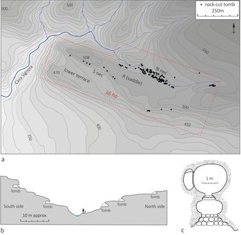
Castelluccio, which gives its name to the Early Bronze Age culture of southern Sicily, is one of the oldest sites in the island where it is possible to apprehend the place of burials in the organization of settlement space (Figs 1–2). Located just below the Hyblaean plateau where it descends towards the Tellaro valley, the settlement coalesced around an elongated promontory with parallel ridges (470 m and 508 m). The higher northern crest, which is occupied by a medieval fort and flanked by a deep stream valley (the Cava della Signora) on its precipitous western side, resembles a narrow acropolis.
(a) Castelluccio plan (after Carta Regionale 1:10,000 sheet 648040, and data added by author); (b) North necropolis valley section sketch (author); (c) tomb 34 (after Orsi Reference Orsi1892, 75).

The archaeological remains are known partly from excavations by Orsi (Reference Orsi1892; Reference Orsi1893) of the rock-cut tombs, which contained multiple inhumations datable mainly to the Early Bronze Age, although a few tombs of the Middle Bronze Age, Iron Age and late antiquity are also visible. Several residential structures have been identified in recent years on the northern ridge and the gentler sloping ground of the saddle (piano sella) (Fig. 2: R), including two houses with 14C dates ranging from c. 2100 to 1900 bc, as well as some evidence for later occupation (Crispino Reference Crispino2018, with bibliography). The lower terrace may also be included in an area for residential or non-funerary activities within the inhabited zone.
A prominent burial ground dominates the northern side of the promontory and the stream valley, which is flanked on both sides by at least 150 tomb chambers, mostly arranged in tiers, extending for c. 700 m from east to west (Fig. 2: N nec). Small groups of tombs are also scattered along the south-facing crags and steep slopes of the promontory for nearly 800 m (Fig. 2: S nec). A combination of slope erosion and old quarrying suggests that many tombs in both cemeteries are no longer visible, but the northern group was probably larger and more imposing.
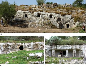
The Early Bronze Age tombs are typically curvilinear with a small antechamber (Fig. 2b), and contained multiple inhumations (below), a small number of pots, flint blades and other items (Crispino & Cultraro Reference Crispino, Cultraro, Militello and Öniz2015; Orsi Reference Orsi1892). Clusters of tombs with adjoining entrances giving onto rectilinear terraces or curvilinear forecourts make for an interconnected and integrated layout. Several tombs preserve vertical façades with a series of pilasters (or lesenes) carved in low relief on either side of the door, while one unusually grand tomb has a large covered vestibule with freestanding pilasters (Fig. 3) flanked by small chambers in what might suggest a subsidiary or supporting role. Vestibules of this type are uncommon in southern Sicily (e.g. Cannata & Scaravilli Reference Cannata and Scaravilli2018; Cugno Reference Cugno2016, 26–33). Castelluccio is also the only site in Sicily where stone door slabs were found with carvings: mainly bosses or spirals combined in probable anthropomorphic representations (tombs 22, 31, 32, 34: Orsi Reference Orsi1892, 28–9, 69–70, 73, 75–6, pls V–VI), one of which (tomb 31) may represent sexual intercourse (e.g. Tusa Reference Tusa2015, 94–8).
(a) Castelluccio North necropolis tombs; (b) Castelluccio North necropolis tomb with lesenes; (c) Castelluccio North necropolis tomb with pilastered vestibule. (Photographs: author).

To summarize, the occupants of Castelluccio juxtaposed their main burial ground along a shallow stream valley with a residential zone on the adjacent plateau and hilltop. Coinciding with an easy routeway around the northern edge of the site, the morphology of the valley allowed this necropolis to take advantage of its opposing slopes and limestone outcrops for the construction of tomb façades and forecourts in a linear arrangement and at different heights and levels. The fewer surviving tombs of the South necropolis also fringed the residential area. They probably lined another route into the site from the south, along which the tombs served as markers, gradually petering out towards the southeast. The main promontory was almost surrounded, therefore, by burial grounds.
The surface area of the site is not easily quantifiable, but the main archaeological zone and some additional ground beyond the tombs, enclosed by the dotted line (Fig. 2), equals about 36 hectares. Within this area, as a very rough estimate, up to about 9 or 10 ha may be regarded as burial grounds on steep or sloping terrain. The extent of the residential zone is unknown, but if it occupied most of the saddle and the high ridge, it would have encompassed about 6 ha, or up to about 10 ha including the lower terrace. One may tentatively hypothesize, therefore, that the ratio of funerary to residential terrain was roughly equal.
B) Thapsos in the Middle Bronze Age
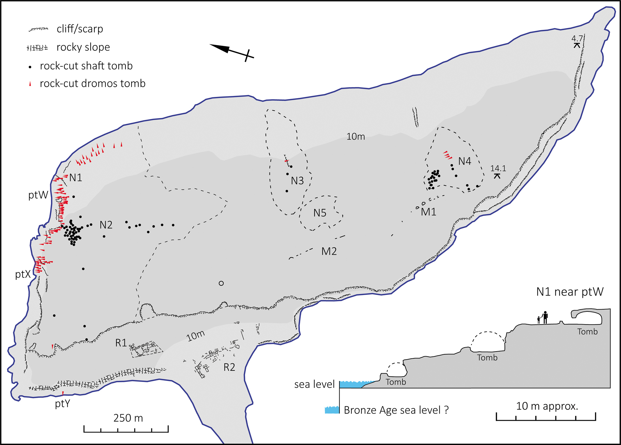
A key site in this region for the Middle Bronze Age (fifteenth–thirteenth centuries bc) is Thapsos (Fig. 4), where we have more information about residential areas as well as extensive burial grounds (Alberti Reference Alberti2007; Orsi Reference Orsi1895; Voza Reference Voza1972; Reference Voza1973). It occupied a low-lying peninsula of c. 115 ha, about 2200 m long and up to 800 m wide, with a maximum elevation of about 19 m, linked to the eastern seaboard by a narrow isthmus. Due to sea-level rise, the shoreline has retreated since the Bronze Age, especially on the western side, where the rock-cut chamber tombs are closer to the water's edge than they were originally and one or two are now partly submerged (Scicchitano et al. Reference Scicchitano, Antonioli, Castagnino Berlinghieri, Dutton and Monaco2008).
(a) Thapsos plan (after Carta Regionale 1:10,000 sheets 646030/646070; Voza Reference Voza1972, tav.1; Reference Voza1992, fig. 1; features added by author); (b) North necropolis coastline section sketch (author).

These tombs held multiple inhumations (see below) and a range of ceramic and other artefacts, although social identities are difficult to infer due to the old records and limited osteological data (Alberti Reference Alberti2006; Rubini et al. Reference Rubini, Bonafede, Licitra, Mogliazza, Moreschini, Voza and Coppa2001; Veca Reference Veca2016). Many tombs contained Mycenaean (LH IIIA–B) pottery of the later fifteenth to thirteenth centuries bc (van Wijngaarden Reference van Wijngaarden2002, 233), supporting the idea, also indicated by the location, that Thapsos was a nodal point in an extensive trading network.
The residential quarter occupied the landward side of the peninsula, where two excavated areas (R1, R2) probably originally formed a single unit. This is partly demarcated by a low scarp, oriented roughly northwest–southeast, bordering the raised limestone plateau, which provides some shelter from easterly winds and the open sea. Dating from phase I (probably fifteenth century bc), zone R1 comprises a system of intersecting trackways flanking several compounds containing round and rectilinear rooms. Zone R2 included a courtyard enclosed by rectangular rooms. Despite modifications and innovations, however, the building history of the Middle Bronze Age (Voza phases I–II) could be regarded as organic insofar as some older buildings seem to have been respected and the original spatial relationships of the settlement were maintained. More significant reorientations occurred in phase III (Final Bronze Age). Two tracts of walling (M1, M2) might have delimited the residential zone to the south, although M1 is thought to pre-date the Middle Bronze Age settlement.
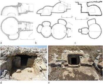
Burial grounds with a variety of tomb types and groupings are widespread. Around the northern shoreline are at least 74 rock-cut tombs (N1), mostly facing seaward, often preserving dromoi and occasionally a vestibule with masonry or pilasters (e.g. tombs 23, 28, 41: Orsi Reference Orsi1895, 110–16, 124) (Fig. 5a, b, d). Quarrying in historical periods has probably obliterated many more (Cavallari Reference Cavallari1880, 134), especially between points X and Y (Fig. 4). According to Orsi (Reference Orsi1895, 94), from 260 to 300 chamber tombs were visible in the nineteenth century.
(a–c) Thapsos tomb plans (after Tomasello Reference Tomasello1995–6, figs. 87, 89, 90); (d) tomb with vestibule; (e) vertical shaft tomb. (Photographs: author).

Set back from the shore is a cluster of at least 35 tombs entered by vertical shafts (N2), a design that is well adapted to flat terrain (Fig. 5c, e). Their entrances are spaced about 5 m or more apart and oriented between north and east. A few others are scattered to the northwest, while small groups lie near the central and southern zones (N3, N4). The shafts were perhaps once marked by a built entrance, as suggested by surface rock cuttings, which would also have helped to prevent water ingress. One or two corridor tombs nearby border a shallow valley oriented roughly east–west. In addition, over 20 jar burials (N5) with traces of individual inhumations were found near N3 and R1 (Voza Reference Voza1972, 200–204; Reference Voza1992, 45–6). These were probably contemporary with the rock-cut tombs and originally covered with earth and stones, resembling small mounds. Many more undoubtedly have not survived.
The tombs on the plateau must have helped to structure a rather featureless open space, while those around the shore (N1), which are easily viewed when circumnavigating the peninsula by boat, delineate a coastal pathway. Their distribution incorporates distinctive groupings and micro-localities adapted to the configuration of the coastline: where the rocky scarp was sufficiently high and steep, the tombs were placed in up to four different levels or tiers (Fig. 4); and where it curved, they followed suit, sometimes forming a hemispherical court (Orsi Reference Orsi1895, 93, fig. 2). The prominence of the cemeteries is also indicated by their size. They cover at least 16 ha, without including the potentially large area of lost (quarried) tombs around the northern edge of the peninsula. By comparison, the excavated residential zone occupies roughly 3 ha, which would rise to about 9 or 10 if we include most of the lower plateau as its hypothetical original extent.
To characterize Thapsos (and all our sites) in terms of just funerary and residential areas is plainly overly simplified. Over 80 ha are blank on the plan, since they lack archaeological evidence. This putative third space could have been for animals, agriculture, waste disposal, crafts, or other activities, while the hinterland terra firma and the sea, each vital for their resources, territorial connections and long-distance trade, could be described as the fourth and fifth spaces. While this may be an over-categorization, the structure and character of the site stem largely from the interplay of these spaces.
C) Pantalica and Cassibile in the Late Bronze and Iron Ages
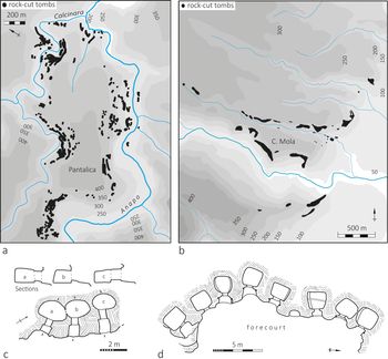
Pantalica and Cassibile are two of the largest Late Bronze and Iron Age sites in Sicily (c. 1250–600 bc), which tend to occupy hilltops or promontories flanked by a river (Fig. 6a, b). Pantalica encompasses at least 240 ha if we include the valley floors and adjacent hillsides where tombs are also located (Leighton Reference Leighton2015; Reference Leighton2019a, pls 1–3), while the burial grounds of Cassibile delimit a roughly triangular area also exceeding 200 ha (Leighton Reference Leighton2016). Both sites probably dominated sizeable territories of 5–10 km in radius. Their importance is further indicated by the very large numbers of tombs and by grave goods implying enhanced craft production and trade (Leighton Reference Leighton2019a; Turco Reference Turco2000). The burial rite entailed inhumation of single or a few individuals in each chamber (below), which could be curvilinear (more especially in the Late Bronze Age) or rectilinear (more often in the Iron Age). Grave goods mostly comprised pottery vessels and metal fibulae, rings, knives, daggers and razors.
(a, b) Pantalica and Cassibile, area maps with main tomb groups and 50 m contours (after Leighton Reference Leighton2015, 191, fig. 2; Reference Leighton2016, 142, fig. 16); (c, d) Late Bronze–Iron Age tombs at Pantalica (after Leighton Reference Leighton2015, 194, fig. 5D, 199, fig. 10A).

Very little is known about the residential areas, which were most likely on the gentler slopes and summits of the promontories, forming a single sprawling unit or various clusters with a corresponding burial ground nearby. It appears that the inhabitants of Pantalica used the different cemeteries contemporaneously, which could reflect a desire to preserve sub-group identities within the community, while demonstrating control over the promontory. As in the case of major ‘protourban’ settlements of the central Italian Iron Age (Pacciarelli Reference Pacciarelli2009, 373), however, large Sicilian sites of this period were most likely unified from a socio-political perspective, rather than aggregations of separate villages.
The promontory of Pantalica is about 2 km long and 1 km wide, with a deep river gorge on three sides. About 2700 tombs are identifiable, although an original number of nearly 4000 has been estimated, comprising at least six major cemeteries, dating from about 1250 to 600 bc (Leighton Reference Leighton2015). Cassibile is also centred on one distinctive promontory (Cugno Mola), bordering the coastal plain and the river, surrounded by large clusters of tombs, but has additional groups on adjacent hills. About 1200 tombs are clearly visible, although the original number was probably closer to 1500, distributed in at least 32 separate groupings over an area of about 6 sq. km.
Regarding the ratio of funerary to non-funerary space, the main promontory at Cassibile has about 17 ha of gently sloping ground, well suited for residential purposes, and c. 20 ha of burial grounds on the steeper surrounding slopes. The equivalent figures for Pantalica are about 60 ha on the main promontory, and roughly 40 ha of burial grounds, without taking account of slope gradients, which increase the surface area of the cemeteries. This is partly why the tombs seem more extensive than might be anticipated from looking at the site plans.
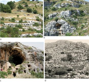
Tombs often coincide with natural routeways or points of access around the main promontories, typically flanking deep stream valleys, which provide shade, caves, rich flora and fauna and unusual acoustics by contrast with the open pasturelands of the adjacent hilltops and plateaus. At the western approach to Pantalica (Filiporto), about 800 tombs take advantage of step-like rock formations creating pathways through the cemetery (Fig. 7a). Tombs on more precipitous outcrops are often just above or below a rock-cut pathway. For example, the crags of the North cemetery (Fig. 7b) overlook the river and the main approach along an old mule-track of probable prehistoric origin. At Cassibile, some smaller tomb groups mark the entrances to stream valleys, while the majority indicate routes around the adjacent hills, perhaps helping to unify an extended locality that did not conform so readily to a naturally demarcated site. As in all cemeteries, clusters of tombs were arranged to create micro-localities, represented at Pantalica by those surrounding an open space resembling a forecourt (e.g. Leighton Reference Leighton2015, 196).
(a) Pantalica Filiporto cemetery (author); (b) Pantalica North cemetery detail (author); (c) Pantalica South cemetery (author); (d) Cassibile tombs in 1896 (von Duhn & Nöhring Reference von Duhn and Nöhring1896, taf. 89).

Continuity and change in settlement layout
While focusing on cemeteries, the foregoing case studies allow comparison of settlement design over a relatively broad time span (from c. 2200 to 600 bc). The sample is limited to four large sites which were likely at the apex of a settlement hierarchy in each period. That they are well preserved and only 20–30 km apart in a landscape unified by geology, relief, soils and hydrology facilitates comparison. Proximity also increases the likelihood that the inhabitants retained knowledge of older sites in the area. At least their tombs would have been visible in subsequent periods and in better condition than they are today. In fact, this is implied by the evidence for later re-use and reoccupation, discussed below.
My starting point in the Early Bronze Age, which is synonymous with the Castelluccio culture, dating from c. 2200 bc, coincides with the first conspicuous embellishment and deployment of large numbers of chamber tombs around major settlements in this region. The Sicilian Copper Age also has rock-cut tombs, but they are less imposing and better represented in western Sicily (Wexler Reference Wexler, Nash and Townsend2016). While undoubtedly drawing on earlier traditions, however, the Castelluccio phase witnessed important developments in funerary architecture. From now on, chamber tomb cemeteries have a prominent place in the spatial organization of large settlements in this region and are still characteristic of indigenous sites during the eighth to sixth centuries bc, which is contemporary with the period of Greek and Phoenician colonization and expansion in Sicily.
In addition to changes in burial practices, the cemeteries indicate a changing relationship with a wider ritual landscape between the third and first millennia bc, which included caves. Frequented since the Palaeolithic, Sicilian caves provide abundant evidence for Neolithic and Copper Age burials and ritual (e.g. Gullì Reference Gullì2014). Aside from any generic resemblance between caves and chamber tombs in this area, their physical association is exemplified at Calaforno, where a natural cavern was extended from at least the late Copper Age by the addition of 35 interconnected rock-cut burial chambers forming a kind of catacomb (Guzzardi Reference Guzzardi1980). This unusual amalgam seems emblematic of a change in emphasis from natural to man-made ritual venues.
This is not to deny some ritual practices in Sicilian caves during later prehistory. Pantalica has several caves near or within its burial grounds, sometimes juxtaposed with rock-cut tombs (Fig. 7c). We do not know if or how they were used, however, and the relatively small quantity of Late Bronze and Iron Age finds from other caves in southeast Sicily seems unrelated to burials (e.g. Tiné Reference Tiné1965). Plainly, while the location of caves was determined by nature, rock-cut tombs allowed for control over the creation of ritual foci. This might conceivably be linked with homologous cultural changes in production. For example, the progressively improving pyro-technologies of metallurgy and refined pottery manufacture, which characterize the Sicilian Bronze and Iron Ages, also entail an increasing appropriation and transformation of natural materials.
By contrast with major Neolithic settlements in eastern Sicily, which occupy low-lying coastal zones, most large Bronze Age sites are on conspicuous hilltops, as in the case of Castelluccio, Pantalica and Cassibile, while Thapsos is a distinctive coastal promontory, a type of location which is also recurrent on the small islands around Sicily (e.g. Lipari, Ustica, Pantelleria). An essentially perimetric distribution of tombs at the four sites and their juxtaposition with residential zones is not necessarily surprising. It is typical of many urban or urbanizing societies and no doubt satisfied certain practical requirements by separating space for the living from the dead. Allocating the latter to steeper slopes or terrain that was less suitable for houses and domestic activities perhaps also helped to ease any anxieties about undue proximity or intrusion.
From a cartographic or aerial perspective, the tombs generally appear to outline or frame a site. Situated between an inner habitation area and an external territory that was presumably less actively managed with increasing distance from the settlement, the cemeteries may represent intermediate transitional places rather than boundaries. In some cases, the move from a burial to a non-burial area seems abrupt, but more usually, as well exemplified at Castelluccio, Pantalica and Cassibile, ever smaller groups of tombs peter out with increasing distance from the main promontory or central point in the settlement. Insofar as it can be estimated, the amount of land allocated to burial does not differ very markedly from that used for non-burial or broadly residential purposes, although this ratio probably changed over time as the numbers of dead increased.
Tombs are recurrently associated with routeways and points of access, such as those indicated by valleys, watercourses, hillsides, or rock formations that people might easily recognize or that animals could instinctively follow. They often appear to formalize or emphasize such natural features and alignments. In certain cases, such as the shaft tombs and jar cemeteries at Thapsos, their topographical associations may seem less obvious and their distribution to invite tacking back and forth in no particular order, but most cemeteries have a linear or sequential arrangement, denoting a circuit route, reminiscent of waypoints or signposts on a planned walk, albeit with notable differences in scale: the Castelluccio North necropolis, extending for c. 700 m, is easily traversed in 10 minutes; a circular tour of the Thapsos cemeteries (c. 3200 m) requires about 45 minutes; and a circuit of the Pantalica promontory along the winding valley bottom, passing most of the burial grounds, a distance of c. 6.5 km, takes over an hour.
The striking prospect and location of many Bronze Age cemeteries, from the valley of Castelluccio to the seashore of Thapsos and the cliffs of Pantalica, must have provided a backdrop for the habitual movements of people and animals. Clustering tombs into large groups and enhancing their entrances is one way to increase their prominence, although the reasons for doing so are debatable. It is not always clear if a particular viewpoint was being prioritized. Views of and from tombs may have been relevant. The tombs on opposite sides of the valley at Castelluccio could be said to observe each other, while those arranged in broad hemispheres comprising dozens or hundreds of tombs at the Filiporto and North cemeteries of Pantalica form rows and tiers, not unlike an auditorium (Leighton Reference Leighton2015, 202). We also find more intimate venues for interaction with the dead created by exploiting the natural terrain to produce a certain configuration or structure, such as a terrace or an enclosed forecourt serving several tombs simultaneously. These places were integral to the performance of funerary rites, as noted below.
From a broader perspective, such comparisons may eventually combine with other aspects of spatial organization that are still poorly documented in order to contribute to discussions about urbanization, a topic which has become ‘somewhat unfashionable’ (Osborne Reference Osborne, Osborne and Cunliffe2005, 1) in archaeology. For present purposes, it must suffice to note that my chronological horizon extends for a millennium before the Late Bronze Age and the more common starting point for analysis of state formation and urbanization in Italian scholarly tradition. The Early Iron Age is generally labelled as a protohistoric or protourban phase and considered to have more in common with later than earlier centuries, especially in central Italy (Etruria and Latium), which is often regarded as unusually advanced in terms of urban development (e.g. Fulminante Reference Fulminante2014; Pacciarelli Reference Pacciarelli2000). In southern Sicily, however, I would suggest that the structuring role of prominent burial grounds in settlement design was already established by the late third millennium bc (or Early Bronze Age). While this does not mean that a process of state formation dates from such an early time, it does suggest that the spatial architectonics of large Sicilian Iron Age sites were deeply rooted in an ancient local tradition.
Continuity and change in tomb form over time
The tombs reflect a sustained investment of labour aimed at creating an enduring architectural space that was well suited to receive multiple depositions and to be revisited and re-used if required. Individual sites may present slightly contrasting details or preferences in tomb form, although these are generally within the broader design trends and criteria of all periods, so that the longer-term development of the chamber tomb in Sicilian prehistory resembles a series of variations on a recurrent theme. In all periods, the entrance is influenced by the form and angle of the bedrock and slope. Vertical shafts are easily adapted to flat terrain, while corridor entranceways diminish in length on steeper ground and are redundant in cliff locations. They slope downward in order to deflect water from the door, which may also be protected by a low step or lip. Such essential principles of design were evidently well established by the late Copper Age, although the Early Bronze Age is further distinguished by more elaborate entrances with carved pilasters (lesenes) or columns and occasionally by anthropomorphic motifs on the door slabs, as seen at Castelluccio. Continuity between periods is exemplified by the presence of lateral niches, antechambers and vestibules in the Early and Middle Bronze Ages (Figs. 2c; 3; 5), and by the persistence of corridor (dromos) entrances from the Middle Bronze Age to the Iron Age (Figs. 5a, b; 6c, d).
A shortcoming of the older legacy data is the limited attention paid to the adjacent exterior spaces of the tomb chambers. From certain well-preserved examples and more recent excavations, however, we know that these areas could have forecourts, terraces and vestibules with additional built or rock-cut structures as well as depositions of human remains, faunal offerings and artefacts (e.g. De Miro Reference De Miro1988–9; Maniscalco McConnell Reference Maniscalco McConnell and Leighton1996; Procelli & Albanese Procelli Reference Procelli and Albanese Procelli2003, 328). In the case of Castelluccio, Orsi (Reference Orsi1892, 16, 27–8) also recorded articulated interments in an open forecourt and vestibule. In some cases, therefore, the intention was not just to enclose, secure and perhaps isolate the dead, but to create more easily accessible venues for ongoing interactive rituals, perhaps allowing contact with their physical remains. Similar considerations probably apply to some later chamber tombs at Thapsos, Pantalica and other sites where Orsi found quantities of pottery in vestibules or dromoi (Leighton & Albanese Procelli Reference Leighton, Albanese Procelli and Leighton2019, 41; Orsi Reference Orsi1895, 95, 98, 100, 112; Panvini Reference Panvini and Tusa1997, 494), which he assumed resulted from looters emptying out the inner chamber in a search for metals. It is more likely in some cases that they were deposited here as a result of ongoing rituals or maintenance activities.
While the main trend over the course of the Bronze and Early Iron Ages is towards plainer entrances and a diminishing concern with external embellishment, the later Iron Age and Archaic periods (eighth–sixth centuries bc), contemporary with Greek and Phoenician colonization in Sicily, see a renewed concern with tomb façades and vestibules. A good example is provided by the entrance porches with benches of eighth-century bc tombs at Villasmundo (Voza Reference Voza1978), while Morgantina shows a marked contrast between the relatively inconspicuous tombs of the Iron Age and their more prominent sixth-century bc successors, provided with pitched ceilings, vestibules and tiled roofs (Leighton Reference Leighton1993, 97; Lyons Reference Lyons1996, 15–21, 123–4). In this period, as in the Bronze Age, these spaces had a role in funerary practices, as suggested by the pottery and human bones found in the vestibules of tombs at Villasmundo (Voza Reference Voza1978, 105).
The architectural development of Sicilian chamber tombs did not follow a linear or straightforward trajectory, therefore, but witnessed phases of greater or lesser elaboration in accordance with the requirements of the associated rituals. At the same time, embellished tomb entrances may well have served to emphasize the prominence or identity of the tomb's occupants relative to others in the same cemetery, or of the entire site relative to others in the area. Unusually conspicuous entrances, such as those at Castelluccio with pilasters or unusually wide façades carved in relief (Fig. 3: b, c), and the more elaborate tombs at Thapsos, could be interpreted in these ways. Plainly, this would be easier to evaluate if we had a detailed record of all tomb types at each of these sites, which is not currently the case. In all periods, and especially in the Late Bronze and Iron Ages, the importance or prestige of a site may have been indicated most conspicuously by the extent of its cemeteries and the numbers of its former, rather than current, inhabitants.
Re-use, remembrance and the rhetoric of rock-cut chamber tombs
The sites and monuments discussed above are representative primarily of certain phases of the Bronze and Iron Ages but evidently retained some functions or assumed new roles subsequently, probably even in those periods for which direct archaeological evidence is missing. Continued occupation or periodic reoccupation of major Bronze Age settlements, especially in the later Iron Age, albeit at a reduced scale or level of intensity, is well attested in this region and sometimes explicable in terms of locational advantages, proximity to natural resources, or the presence of re-usable materials. Their prominent burial grounds would lend additional agency to these places, while evoking ancestral memories or mythologies.
Discussion here centres on the renewed use of tombs and cemeteries for burials over time and after long gaps, which is a common occurrence in this region. It is also noteworthy, however, that prehistoric chamber tombs were occasionally re-used in much later periods for entirely different purposes. Tombs at Pantalica were sometimes enlarged and incorporated into rock-cut dwellings, a practice which has generally been dated to late antiquity (Blake Reference Blake, van Dyke and Alcock2003; Orsi Reference Orsi1899), but which requires further research. I have argued that it could have begun in the fourth century bc or earlier (Leighton Reference Leighton and Militelloin press).
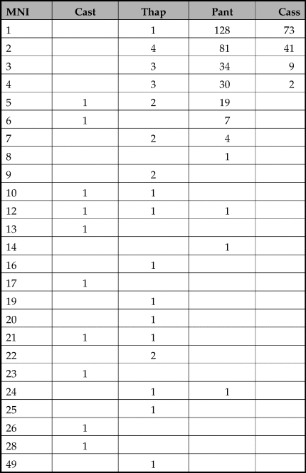
In order to assess re-use for burial, the prescribed or expected service life of tombs requires consideration. We should point out that information regarding human remains from the tombs at our four sites derives mainly from the useful but limited observations of the first excavator, Paolo Orsi. Nevertheless, it is clear that the number of interments per tomb declined over time: 10 Early Bronze Age tombs of Castelluccio contained between 5 and 28 skeletons, a total of 161 individuals, which gives a mean of about 16 per tomb; 28 Middle Bronze Age tombs at Thapsos held between 1 and 49 individuals, a total of 312, with a mean of just over 11; 307 Late Bronze and Iron Age tombs at Pantalica held between 1 and 24 individuals, a total of 735, with a mean of 2.4; and 125 Late Bronze and Iron Age tombs at Cassibile had between 1 and 4 individuals, a total of 190, and a mean of just 1.5 per tomb (Table 1).
Minimum number of individuals from corresponding numbers of chamber tombs at Castelluccio (EBA), Thapsos (MBA), Pantalica and Cassibile (LBA–IA). (Data from Orsi Reference Orsi1892; Reference Orsi1895; Leighton & Albanese Procelli Reference Leighton, Albanese Procelli and Leighton2019; Turco Reference Turco2000.)

As the tombs with the highest numbers of skeletons, those of Castelluccio must have required more frequent reopening and rearranging in order to accommodate additions. No more than four or five adult corpses could fit into most Early Bronze Age chambers of c. 2 m in diameter. Although the sequence of interments and time-lag between each is not discernible, these tombs would have had a longer use-life than those of later date in which the numbers were restricted. Moreover, while a few articulated skeletons were found in the Castelluccio tombs, it is not proven scientifically that all the disarticulated bones were from primary burials, or that bones were all retained permanently within the chambers along with all grave goods.
Notwithstanding these uncertainties, the greatly reduced numbers of individuals in the later Bronze and Iron Age tombs is a significant change. On average, whereas 100 people at Castelluccio required 6 chamber tombs, 100 people at Cassibile required 67. Unless the latter were regularly re-used by removing older burials after a certain time lapse, for which there is no evidence, the later cemeteries must have demanded more labour. The placement of each new tomb would have been a matter for frequent deliberation, allowing a cemetery to expand rapidly over wide areas of ground. Many of these tombs were heavily blocked with door slabs or stone and rubble, perhaps when they no longer required reopening, at which point they probably became less conspicuous and needed no further maintenance. This is doubtless why their skeletons were often still articulated. The large numbers and short use-lives of these tombs perhaps militated against external embellishment of their entrances, although their dense clustering on conspicuous rock outcrops could represent an alternative form of monumentality, through force of numbers rather than individual elaboration.
Whether we can deduce much about changing social identities or notions of personhood over time from these considerations is a question best confronted in conjunction with a detailed analysis of grave goods, which is not the aim of this article. Nevertheless, one may suggest that the later preference for single or double burials helped to create temporal and biographical mnemonics consistent with time-reckoning methods linked to the memory of specific individuals and named ancestors. The appearance of exceptional tombs of the early historical periods in this region, which depart from established norms of design, and the proliferation of different funerary rites, seem partly explicable with reference to individual commemoration and to expressions of changing cultural identities. One example from the sixth century bc is the large grave with a warrior sculpture at Castiglione (Ragusa), distinguished by unusual design, ritual, scale and contents that draw upon diverse sources and practices (Shepherd Reference Shepherd, Gleba and Horsnaes2011, 120–22).
The re-use of Bronze Age chamber tombs after long time intervals is also well attested in this region. Two of the 35 tombs at Castelluccio excavated by Orsi (Reference Orsi1892, 11, 26) contained later or Iron Age (late eighth/seventh century bc) burials superimposed in a layer above older, almost certainly Early Bronze Age, depositions. Some entirely new tombs were probably also created here in the Iron Age (e.g. Orsi Reference Orsi1892, 13, sep.4). Thapsos tomb 8 had a sterile layer between its lower Middle Bronze Age depositions and the two skeletons with grave goods inserted in the late eighth century bc, after a gap of c. 500 years (Orsi Reference Orsi1895, 103). At Pantalica six tombs were re-used for burial between the sixth and fourth centuries bc and at least two more in the late antique period (Leighton Reference Leighton and Leighton2019b, 57). In one case (t. SC185), the fourth-century bc burial was inserted above a soil layer covering late Iron Age (late eighth/seventh century bc) burials. More frequent evidence for Iron Age re-use of Early Bronze Age tombs, without removing the original interments, comes from several smaller sites in the region, such as Villasmundo (Voza Reference Voza1978, 104), and Cozzo delle Giummare (Orsi Reference Orsi1897), where it may have involved the revival of the entire cemetery.
It is debatable whether these much later interments in old tombs were merely a form of expedient re-use, unconcerned with the past, or whether they were driven or influenced by a conscious desire to establish a connection with what was there before. At least they show knowledge and appreciation of the original purpose and continuing viability of these localities, which inevitably creates a link with the past. Perhaps the long interlude since the first interments nullified any sense of desecration or infringement, more especially in cases where the original occupants were left in place. In cases where the tomb chambers seem older in form than their contents, one can infer that they were either already found empty or emptied out as a precursor to re-use. The rearrangement and removal of a tomb's contents, however, could have various motivations from ritually prescribed acts of observance to chaotic looting. As noted above, it is not always easy to distinguish between these from the older records. Whether or not sanctioned, however, even looting represents a form of rediscovery and re-use, or recycling.
One may argue, therefore, that the development of a rock-cut tradition of funerary architecture in this region was not simply an adaptation to the local lithology, but a self-referencing phenomenon, aided by periodic re-engagement with the cemeteries of older sites. In fact, this is not surprising in a burial-rich landscape in which tombs, rather than houses, offered the most direct and durable aide-mémoire for collective and individual histories.
In conclusion, as a historically documented example of the beguiling ways in which funerary rhetoric could work in this region, we may recall Cicero's account of his discovery in 75 bc of the tomb of Archimedes in the cemetery of Syracuse (Cicero, Tusculan Disputations, 5.64–5). He claims the tomb was lost, but that he found it, obscured by vegetation, which he cleared away to reveal an eroded epitaph surmounted by a stone sphere and cylinder, commemorating Archimedes’ works and theories. Evoking the power and durability of stone in acts of remembrance, and gaining credit for the discovery, Cicero's rhetoric shows how easily the illustrious, if conveniently silent, dead can advance the ambitions and prestige of the living (Jaeger Reference Jaeger2002). The fact that Archimedes had been killed by a Roman soldier and that his tomb was in poor condition, half-forgotten and hidden, hardly mattered. In fact, it was an advantage, as it presented an opportunity for atonement, re-identification and rehabilitation.
Conclusions
In this article I have proposed that the reproduction of locality in southeast Sicily entailed the adoption of recurrent spatial principles and practices in a specific landscape context over the entire course of the Bronze and Iron Ages (c. 2200 to 600 bc). These are identifiable in the layout of major settlements in which rock-cut cemeteries had a prominent structuring role, as is well exemplified by the complex ritual geography of Thapsos. Characteristic features include a high ratio of burial to residential or other non-funerary space, and the deployment of tombs in linear patterns or dense clusters around such areas in correspondence with distinctive natural features, such as stream valleys, routeways and points of access.
The essential forms of rock-cut chamber tombs did not alter markedly over the course of the Bronze and Iron Ages and were partly conditioned by the chosen location and terrain. Certain features, however, such as entranceways, were subject to greater or lesser embellishment, suggesting a cyclical or non-linear pattern of development. Differences in design may be ascribed in part to variations in funerary practice, including the larger numbers of interments per tomb in the Early to Middle Bronze Ages, compared to the Late Bronze and Iron Ages, and the performance of rituals in exterior spaces, such as vestibules and forecourts.
Due to their large numbers, durability, visibility and adaptability, rock-cut tombs could help to mark time as well as space, especially in the Late Bronze and Iron Ages. In a landscape where prominent older sites and monuments had a persistent agency, the tombs offered opportunities for asserting or reinforcing links to the past, as exemplified by the insertion of new burials into older chambers, often after a long gap between the Early Bronze Age and the later Iron Age. While particularly well suited to the limestone geology of southeast Sicily, the tradition of rock-cut funerary architecture was partly sustained by re-engagement with the cemeteries of older sites in a consciously self-referencing manner through acts of re-use and remembrance.
From a broader temporal and geographical perspective, this case study from southern Sicily also serves to exemplify the often persistent and distinctive regional nature of cultural traditions in later Mediterranean prehistory, which are especially well represented in the western islands.