
Introduction
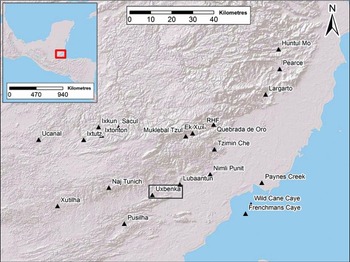
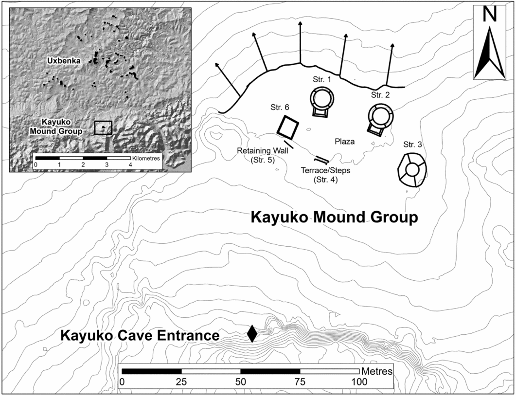
In 2007, while investigating Kayuko Naj Tunich (KNT), or ‘Canoe Cave’, an ancient Maya ritual site associated with the mid-sized polity of Uxbenkà in southern Belize (Figure 1), we located the Kayuko Mound Group (KMG), a cluster of low structures concealed by dense jungle. The mounds interested us because of their proximity to the cave entrance (Figure 2). In Mesoamerica, caves are almost exclusively used as ritual spaces that materialise cosmology (Brady Reference Brady1997; Brady & Ashmore Reference Brady, Ashmore, Ashmore and Knapp1999; Brady & Prufer Reference Brady, Prufer, Prufer and Brady2005; Moyes & Brady Reference Moyes, Brady and Moyes2012). Caves have mythical associations with primordial humans and are thought of as entrances to the sacred earth, as well as to the underworld (Heyden Reference Heyden1975; MacLeod & Puleston Reference MacLeod, Puleston, Robertson and Jeffers1978; Moyes Reference Moyes and Brady2012), a fearsome place inhabited by evil overlords. More beneficent deities were associated with the cave mouths, including Chac, the rain god. Based on ethnohistoric documentation, Mesoamerican settlement choices during the establishment of early communities focused on the importance of caves where these deities could be propitiated (García-Zambrano Reference García-Zambrano, Robertson and Field1994). Thus, it is not surprising that over time, caves became places of power that could be used to legitimate elite authority (Brady & Prufer Reference Brady, Prufer, Prufer and Brady2005; Moyes & Brady Reference Moyes, Brady and Moyes2012; Moyes & Prufer Reference Moyes and Prufer2013).
Map of southern Belize showing location of Uxbenkà (image courtesy of the Uxbenkà Archaeological Project).

LiDAR-based map showing the ritual complex (Kayuko Naj Tunich and the Kayuko Mound Group); inset shows its proximity to the Uxbenkà site core (image courtesy of Uxbenkà Archaeological Project and Uxbenkà Cave Project).

Although it is not unusual for surface architecture to be associated with caves (Moyes & Brady Reference Moyes, Brady and Moyes2012; Moyes et al. Reference Moyes, Robinson, Kosakowsky and Voorhies2012), studies of the relationship between the two remain undeveloped. The Uxbenkà Cave Project (UCP) represents one of the first sustained efforts in Mesoamerican archaeology to contextualise ancient cave use within the historical and socio-political events associated with a particular polity. Moyes and Prufer (Reference Moyes and Prufer2009, Reference Moyes and Prufer2013) suggested that Kayuko Naj Tunich was a foundational ritual shrine where early rulers conducted ceremonies in the establishment of political hierarchies and the formation of the Uxbenká polity as a geopolitical entity. It was within this context that we investigated the KMG.
In 2009, we initiated a programme of clearance, mapping, chronology building, investigation into construction techniques, and broad horizontal excavations. Both the cave and mounds are situated on a karst tower located high above the river, away from farms and houses, suggesting that the complex was a place of pilgrimage, or may have functioned as a ‘festival site’. Kit Wesler (Reference Wesler and Wesler2012) pointed out that pilgrimage sites are typically used more or less continually, and sustain a local population, whereas festival sites are visited by relatively local groups on special occasions, and are cleaned up and left empty most of the time. We hypothesise that the KMG may have been erected for a single event or a series of events connected with the cave, before falling into disuse, and posit that, as a festival site, the KMG would have been less probable to display a programme of sustained building or rebuilding, and exhibit less elaboration than a pilgrimage site that underwent continual usage. Constructions that were intended for temporary use could be built quickly with less labour input than those intended for repeated use. Iconography demonstrates that temporary wooden structures, such as scaffolds, were erected for ancient Maya accession rights, but that these do not survive in the archaeological record (Schele & Miller Reference Schele and Miller1986: 112).
To test this hypothesis, we wanted to ascertain: 1) whether the mound group dated to the same period as the cave; 2) if it was built in single or multiple phases; 3) how much material was used in the construction; and 4) how much labour and time were involved in its construction. For dating the sites, we relied primarily on AMS dates from excavated charcoal. Dates were processed by the University of Oregon Archaeometry Facility and the University of California Irvine Keck Carbon Cycle AMS Facility. Our samples are reported as 2-sigma calibrated ranges (95.4% probability). Calibrations were produced using OxCal 4.0, employing the IntCal04 atmospheric curve.
To address the later questions, we turned to energetics. Architectural energetics translates the volume measurements of structures into a case-specific value of labour-time expenditure (Erasmus Reference Erasmus1965; Arnold & Ford Reference Arnold and Ford1980; Folan et al. Reference Folan, Kintz, Fletcher and Hyde1982; Bomgardner Reference Bomgardner1983; Abrams Reference Abrams1987, Reference Abrams1994; Ford Reference Ford1991; Webster & Kirker Reference Webster and Kirker1995). Such an approach considers energy expenditure in the procurement, transport, processing and placement of material for each element of construction, and provides a quantitative estimate of how many days it took to construct the locus.
In the Americas, these studies have typically been used to quantify levels of cultural complexity, social inequality and the ability to mobilise labour (e.g. Cheek Reference Cheek, Urban and Schortman1986; Kolb Reference Kolb1994, Reference Brady1997; Lacquement Reference Lacquement2010; Rosenswig & Burger Reference Rosenswig, Burger, Burger and Rosenswig2012; Torres et al. Reference Torres, Antonio Curet, Rice-Snow, Castor and Castor2014). Elliot Abrams (Reference Abrams1987, Reference Abrams and Schiffer1989, Reference Abrams1994, Reference Abrams and Houston1998) conducted the most sustained research on architectural labour investments in the Maya area at Copan in Honduras, focusing on energetics as a method to infer socio-political organisation, and framing his work within a ‘Behavioral Approach’ to understanding site formation processes as proposed by Michael Schiffer (Reference Schiffer1987). Building on Abram's work, Christine Carelli (Reference Carelli, Bell, Contuto and Scharer2004) investigated the sequences of construction and destruction of Acropolis structures in an effort to relate known historical events with Copan's dynastic sequence, using energy costs as a proxy for understanding the amount of power wielded by particular rulers.
As with other energetics research, the importation of local raw materials used to construct the KMG and estimates regarding their transportation costs are of central importance. Here, we turn to experimental archaeology to quantify the labour costs of carrying materials to the site. Our study differs from others in that there is less concern with the ability to mobilise labour as a proxy for increasing social complexity as there is for the ideological factors at play when establishing the right to rule. Energetics are used to understand the site's functionality within social and political contexts, and to emphasise how ideological aspects of the constructed environment and its association with a sacred landscape served as a resource for building and maintaining political power. Our study thus discusses how energetics are key to understanding the public ritual and performance that was integral to the development of early Maya rulership.
Kayuko Naj Tunich: an ancient Maya cave shrine
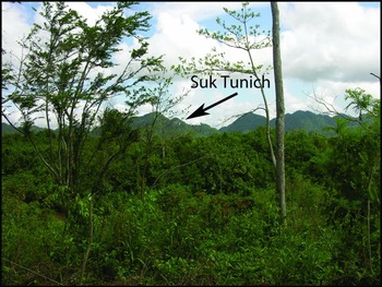
The KMG is located 2.3km south of the mid-sized polity of Uxbenkà, which is currently under investigation by the Uxbenkà Archaeological Project directed by Keith M. Prufer. Uxbenkà is the earliest major centre in southern Belize (Prufer et al. Reference Prufer, Moyes, Culleton, Kindon and Kennett2011). It existed as a village prior to becoming a stratified polity; the emergence of political elites and public architecture dates to between AD 135 and 338 (modelled Cal 2σ, Culleton et al. Reference Culleton, Prufer and Kennett2012). The group is part of a ceremonial complex that includes the ancient Maya cave site KNT, which is situated on a karst tower known to locals as Suk Tunich (White Rock in Mopan Maya), and which rises 200m above the Rio Blanco river. From this promontory, both the KMG and the cave have a clear view to the Uxbenkà site core or centre and, conversely, the exposed white cliff face of the karst tower can be easily viewed from plaza A, the Stela Plaza, which is set on a hilltop in the eastern part of the Uxbenká site core and contains six known structures and 23 recorded stelae (Figure 3).
View from Uxbenkà site core to the ceremonial complex (photograph by Holley Moyes).

KNT is one of the most architecturally elaborated caves in the Maya lowlands, complete with stairways and plastered floors and walls. Abutting the back wall of the cave was a formal masonry altar upon which sat a carved wooden altarpiece in the shape of a basin or small ‘canoe’, hence the cave's name. Based on an AMS date from a wooden beam supporting the floor fill and associated artefacts, the cave shrine's initial construction dated between cal 240–339 BC (UCIAMS-42799), which lies at the Terminal Preclassic/Early Classic transition and which is contemporary with the first monumental construction programme at Uxbenká (Moyes & Prufer Reference Moyes and Prufer2009, Reference Moyes and Prufer2013; Prufer et al. Reference Prufer, Moyes, Culleton, Kindon and Kennett2011; Culleton et al. Reference Culleton, Prufer and Kennett2012). Non-overlapping AMS dates from support beams demonstrate that the cave was maintained or reconstructed over the Early Classic period until about AD 600. The line of sight between the cave and the site core, the presence of a monumental construction programme that required organised labour and the coeval construction of the cave shrine with the building of the first stone architecture at Uxbenká led Moyes and Prufer (Reference Moyes and Prufer2009, Reference Moyes and Prufer2013) to conclude that the cave was a foundational shrine that served as a ceremonial venue for early leaders at Uxbenkà. They argued that cave rites were integral to establishing political power in the formation of the Uxbenká polity as a geopolitical entity, and suggested that the cave may have even been used for early accession rights.
Kayuko Mound Group
The KMG sits on the north-facing karst tower 65m below the cave entrance. It is situated on a flat natural terrace abutting the steep slope that ascends to the cave. The structures in the group are oriented around a 20 × 50m open plaza (see Figure 2). They include three formal buildings (structures 1, 2 and 6), a large stone pile (structure 3), remnant terraces (structure 4) and a low retaining wall or terrace (structure 5). Both structures 1 and 2 are circular platforms with rectangular aprons protruding onto the plaza. The structures measured 1.7m in height and 10.3m and 10.8m in diameter respectively. The exterior apron on structure 1 measured approximately 6.3m across, extending 3.5m from the circular core of the structure. The exterior apron of structure 2 was partially intact, measuring 4.85m across the south side of the structure's core, and extending 2.4m out from it. Our excavations and inspection of looters’ trenches demonstrated that these were single phase structures with no evidence of prior construction or subsequent remodelling.
In the construction of the buildings, the circular platforms were laid first and the aprons added afterwards. The interior of the structures were composed of dry-laid core fill of unmodified limestone boulders. The largest examples (1.02–2.05m), weighing over 45kg, provided a base, while medium (0.51–1.02m) to small (0.26–0.51m) boulders comprised the bulk of the fill. Cobbles and soil were used on top to level the floor and tamped to create a hard surface. Limestone boulders are abundantly available on the slopes above and below the terrace. No dedicated quarry has been identified, and much of the construction material was probably collected from the ground surface, or mined from the exposed patches of bedrock, with minimal energy expenditure.
The boulder construction core was faced with natural sandstone blocks laid 15–20 courses high to finish the outside walls at 1.7m tall. The structure's aprons were constructed similarly with dry core fill and sandstone blocks that abutted the circular part of the buildings. The closest source of sandstone is 1km below the KMG at the Rio Blanco, in which the sandstone bedrock naturally fractures into sheets that average 10cm in thickness. An abundance of tabular rocks, identical to those employed in the ancient architecture, are naturally present in the river and require no further processing, just transportation.
Structure 6 was a low, single-phase rectangular platform measuring 7m on its east--west axis and 8.3m on the north--south axis, standing 0.54m in height. It was constructed using the same techniques as structures 1 and 2: dry core fill, finished with an unmodified sandstone block facing 3–4 courses high. The tops of the structures were flat and had been levelled using pebbles, small cobbles and dirt. No evidence of mortar or plaster was noted on any of these constructions, and none of them contained internal caches or burials.
Structure 3 is an informal pile of small-, medium- and large-sized boulders set against the hillside. No sandstone blocks were associated with this feature and the top was not levelled. It is possible that it may in fact be a pile of boulders cleared from the central plaza, or alternatively the dry-core fill of an unfinished structure. Structure 4 appears to be two steps or terraces approximately 2m in length and 0.5m in height, and composed of 2–3 courses of sandstone blocks. The steps modify the natural rise of the hillside and lead to a natural path to the cave. Structure 5 is the remnant of a low retaining wall that also modifies a section of the hillside, creating a pathway between the slope and structure 6. This may have created a formal entrance into the plaza from below the cave. Only a relatively small amount of material was employed in the construction of structures 4 and 5.
Few artefacts were associated with any of the structures, and what little there were consisted primarily of ceramic sherds. In the 2009 excavations, we collected a total of 633 sherds and a single obsidian blade. The identifiable sherds represented 68 jars, 16 dishes, 15 bowls, 5 vases and a few censer fragments. The bowls were small and probably used as drinking vessels. The limited number of ceramic forms and lack of other artefact classes such as grinding stones, lithics, bone tools, spindle whorls and shell, typically found in Maya households, further support our proposition that this was a special purpose site. The limited assemblage and small sherd count is consistent with expectations of ritual sites that were used infrequently, such as caves. For instance, the main chamber at Actun Tunichil Muknal, dating to the Late to Terminal Classic periods, contained only 1408 ceramics. This is a small number compared with domestic contexts where a household excavation can produce tens of thousands of sherds.
Five AMS dates were obtained from the excavation of the structures. The date ranges recorded from structure 1, of 38 BC–AD 58 (UCIAMS-91209) and AD 5–79 (UCIAMS-91212), are terminus post quem and indicate that the structure was erected after these probability ranges. The later date suggests that the building could not have been constructed before 5 BC. A third sample collected from the base of the exterior wall beneath the apron fill suggests a range of AD 129–228 (UCAIMS-73785), but a fourth sample collected from the base of the interior side of the wall belonging to structure 1 was dated to AD 217–331(UCAIMS-91210). This date from the structure's interior is perhaps more reliable in terms of dating the building's construction, and agrees with the sample from the base of the wall belonging to structure 2, collected directly beneath the apron fill, that provided a date of AD 240–334 (UCAIMS-91208), placing both constructions in the mid-third to early fourth centuries AD, at the Late Preclassic to Early Classic transition. We therefore conclude that the buildings are contemporaneous not only with each other, but with the initial modification of the cave, which fell between AD 240–339.
Energetics at the Kayuko Mound Group
The energetics study consisted of two components. The first sought to ascertain and quantify the materials used in the construction of the KMG, and the second was to locate the source of the materials and compute transportation costs. The transportation of sandstone blocks incurred the highest labour cost for construction, and, in order to calculate labour costs, we used an experimental approach to collect specific, real-world data for our study.
The labour study was designed in conjunction with the K'in Ajaw Association, the local indigenous group established to oversee the stewardship of the archaeological, cultural and natural resources in the village of Santa Cruz. The village leaders decided we should employ male high-school students, aged 16–17 for our study, to help fund the cost of textbooks in their schooling. The K'in Ajaw Association selected five individuals from among the eligible members of the village.
The experiment required the five participants to carry loads of their choice (weight, size, shape, number of rocks) from the river to the mound group over a four-hour period, including all rest times. The hike, along an old footpath that was freshly cleared and crossed low hills, then ascended the steep slope of the rock patch to the KMG. The participants were allowed to use a rice sack (under the assumption that baskets were available in antiquity), and could carry the load either in their arms, or via a tumpline (suspended over the back from a strap across the forehead). The loads were weighed and their journeys timed.
Each participant was paid a standard rate for a full day's labour (US $25), as determined by the K'in Ajaw Association and in line with that paid by the Uxbenká Archaeological Project. An extra 10 cents was awarded for each pound (0.453kg) of weight the participant carried. We used the cash bonus to give participants enough incentive to try harder, rather than simply claiming the fee for participating. At the same time, the amount was not high enough to provide a false motivation whereby the rewards promoted maximum exertion that would be neither physically sustainable nor reflect reality in all probability. In a labour study in Mexico, Erasmus (Reference Erasmus1965) was forced to bring a halt to an experiment as the participants were working at an unsustainable rate to exploit the payment structure. Alongside the financial rewards, the participants in our study added an element of friendly competition to the experiment that acted as a motivator.
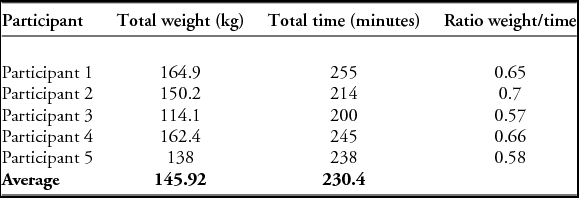
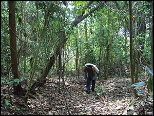
Each participant made four trips in a four-hour time limit from 8am–12pm. These data are summarised in Table 1. Loads varied between 25kg and 60kg, with each one-way trip ranging from 13–61 minutes. The five participants employed different strategies to loading, ranging from carrying many smaller stones in the rice sack, to hauling a single large stone using a tumpline or headstrap (Figure 4). Participant 1 increased the load dramatically and ultimately carried the most, but suffered increasing trip times. Participant 3 consistently selected a lighter load and enjoyed faster ascents, completing his four trips in the least time. Participant 2 was the most efficient in terms of weight to time ratio. A longer time frame might have produced more consistent performances as participants standardised the load, hiking speed and rest time, improving efficiency as their strategies adapted to the activity. We consider that our study provides a conservative estimate of the labour costs. Based on data from the experiment, a person can carry 36.48kg in 57.6 minutes from the river to KMG in an average trip that includes rest times. Therefore, the average transport cost is approximately 38kg per labour hour.
Labour cost for carrying sandstone blocks from the river to the KMG.

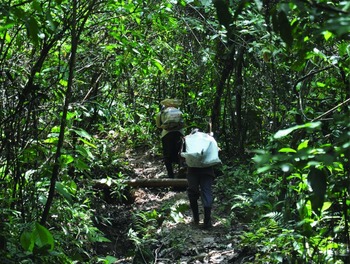
Participants carry stones on tumplines during experiment (photograph by Mark Robinson).

In the second phase of our study, we used data collected from our excavations of the structures to calculate the amount of material needed for their construction. We included structures 1, 2 and 6 in the study, and excluded structure 3 from our calculations because it appeared to be either unfinished or not part of the initial construction. During our excavations, we calculated the amount of material used in the building constructions by weighing and measuring limestone boulders and sandstone blocks as they were removed by excavators. We estimated the number of sandstone blocks used to face the structures based on their size where sections of the walls remained intact. Structure 2 was heavily looted, but structure 1 was mostly intact. Therefore, materials from a conical-shaped unit with a 4m diameter at the base and a depth of 1.7m where bedrock was encountered, were used to calculate the number of limestone boulders needed for construction fill. Although there were larger boulders at the base of the structure, trending to medium and smaller boulders at the top, the limestone fill was assumed to be homogeneous for the purposes of this study. Our calculations are based on an average size according to our database of 526 boulders.
All material removed from the excavation was weighed and measured along three axes to provide an estimate of volume. The total volume of the excavated material was 5.46m3, weighing 5750.70kg. The excavated material was compared to the total area of the cone to generate a value for the amount of material required to fill a known three-dimensional space. The excavation was assumed to be a perfect cone, whose volume was calculated as:
 $$\begin{equation*}
{\rm{V}}\;{\rm{ = }}\;{\rm{h}}\;{\rm{\pi }}\;{{\rm{r}}^{\rm{2}}}{\rm{/}}\;{\rm{3, where}}\;{\rm{h}}\;{\rm{ = }}\;{\rm{1}}{\rm{.7m}}\;{\rm{and}}\;{\rm{r}}\;{\rm{ = }}\;{\rm{2m,}}\;{\rm{meaning}}\;{\rm{that}}\;{\rm{V}}\;{\rm{ = }}\;{\rm{7}}{\rm{.1238}}{{\rm{m}}^{\rm{3}}}
\end{equation*}$$
The excavated material accounts for 76.67% of the volume of the cone. This figure can be scaled to the size of the entire limestone fill incorporated in the main body and apron of the structure. Structure 1 has a diameter of 10.3m, with an internal fill diameter of 9.7m (allowing for a 0.3m exterior sandstone wall), and a height of 1.7m. Assuming the structure is a perfect cylinder (V = h π r2), the main body has a volume of 125.56m3, requiring 96.27m3 of limestone fill. The apron measured 5.7m wide, 3.5m deep, 1.15m tall and would have had an internal limestone volume of 18.768m3, requiring 14.39m3 of limestone fill. Therefore, the total amount of limestone fill required for structure 1 was 110.66m3.
The volume measurements can be converted to weight based on the measurements collected from the excavation. The weight of the limestone required per cubic metre of space can be calculated by dividing the weight of the material from the excavation by the volume of the cone, and this value can be applied to the total volume of the structure. In this case:
 $$\begin{equation*}
{\rm{5750}}{\rm{.70/7}}{\rm{.1238}}\;{\rm{ = }}\;{\rm{807}}{\rm{.25kg}}{\rm{/}}{{\rm{m}}^{\rm{3}}}
\end{equation*}$$
The total weight of limestone required to fill structure 1 was 110.66m3 × 807.23 = 89 330kg. The transport costs for sandstone from the river were applied to the required limestone fill, allowing a generous search time and thereby providing an overestimation of actual labour costs, although we expect that the limestone could be collected much closer to the site, meaning this is somewhat overestimated. Based on the transport costs of 38kg of material per hour generated from the energetics experiment, the transport of limestone for structure 1 required 2350.79 hours of labour.
Direct measurement of in situ sandstone facing stones was not attempted so as to preserve the intact ancient structure. Loose sandstone blocks were measured and weighed to generate a value of sandstone weight per volume. Field observations of intact walls record an average-sized block as measuring 0.3m wide, 0.1m tall and 0.3m deep (V = 0.009m3). Based on volume and weight measurements of sandstone blocks at the site, a 0.009m3 volume block weighs 17.45kg. These values are assumed in all subsequent calculations.
With an average of 30 sandstone blocks per 1m2 of wall face, and 68.24m2 of faced wall on the main circular body and the apron, structure 1 required 2047.24 tabular sandstone blocks, weighing 35 724.38kg (V = 18.43m3), with a transport cost of 940.12 hours of labour. The total labour costs for structure 1 (sandstone and limestone) are 3290.91 hours. The cost of positioning the construction material is considered as zero, following Abrams (Reference Abrams1994: 118); the relatively crude construction technique did not require high levels of planning and masonry skill, and thus would have incurred minimal labour costs, easily accounted for by the systematic overestimations incorporated into the labour calculations.
Volume and labour are calculated in the same way for the similar shaped structure 2. The volume of the interior area of structure 6 is calculated as a rectangle, allowing a 0.3m exterior sandstone wall:
 $$\begin{equation*}
{\rm{V}} = {\rm{l\;^*}}\;{\rm{w}}\;{\rm{^*}}\;{\rm{h}},
\end{equation*}$$
where l = 7.7, w = 6.4 and h = 0.54, meaning that V = 26.61m3, and thereby requiring 20.41m3 of limestone material.
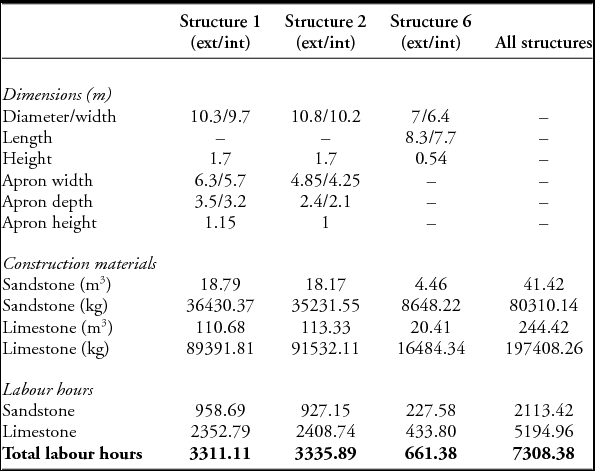
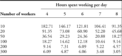
The dimensions and labour calculations for each structure are summarised in Table 2 and are based on previous energetics studies that suggested a 5–8 hour workday (Erasmus Reference Erasmus1965; Abrams Reference Abrams1994; Arco & Abrams Reference Arco and Abrams2006). The same technique used to calculate labour costs for structure 1 was applied to structures 2 and 6. The total labour cost for constructing the three structures was 7308.38 hours. Table 3 calculates the number of days needed for the construction of the three structures, taking into account variable hours working in the day and the number of workers employed.
Structure form and labour hours.

Number of person-days needed to construct KMG.

Although we have no real way of estimating the number of people involved in the site's construction, we can discuss some possibilities. Uxbenká supported a population of 1500–2600 at the start of the Early Classic period (Culleton Reference Culleton2012). Using the low end of this estimate, and assuming a 5-person household composed of a mating couple and their offspring (Haviland Reference Haviland1972), and a 10% elite population who were removed from communal labour debt, projects directed by these elites may have conscripted one male labourer from each of around 270 households. Despite a systematic overestimation of costs, the data show that the KMG could easily have been constructed in 30 days with 50 people working 5-hour days, or, if we consider 200–300 people, it could have been completed between 5 and 8 days (Table 3). This demonstrates that the number of days required to erect the site would not have been burdensome to workers, particularly if construction occurred during the agricultural off-season. This would also leave ample time for participation in other civic projects.
Conclusion
We have proposed that the KMG was part of a ritual complex associated with the foundation of the Uxbenkà polity. The site's proximal association to the cave located on the karst tower directly above suggests that the two were integrally connected. AMS dates for the initial construction of both the cave shrine and the mounds are so close in range that it is probable that they were constructed at the same time or within a few years of each other. While the cave had a long history of re-use and reconstruction, the KMG exhibited a single construction phase and a short use-history. Our energetics study suggests that the KMG could reasonably have been constructed in a month or less depending on the number of people working on the project. The remote location of the group, rapid construction from locally available materials and simple building technique lends support to the notion that the KMG was used as a ‘festival’ site rather than a long enduring place of pilgrimage. In this way they are comparable to structures erected for fairs or festivals that fall into disuse or are torn down after the event.
This lends support to Moyes and Prufer's (Reference Moyes and Prufer2013) suggestion that KNT was the venue for the accession rights for the initial royal dynasty of Uxbenkà. We expect that such an important event would have been attended not only by elites, but by commoners as well. The small size of the cave would have accommodated private esoteric rituals for the elite, but larger ceremonies involving the wider public could easily have been held at the KMG. The display of power that we argue for is not based on perpetual monumentality, or even the profligate use of labour for elite enterprises, but rather represents the ability of the ruler to harness the power of the landscape itself. The strategy was to gather the community to witness the early ruler's ties and commitments to the earth's local indwelling deities. The site provided a vehicle for formalising this relationship—a performance space that could have easily been abandoned following the festivities without having invested an inordinate amount of labour. In this model, the cave continued to be used as a place of pilgrimage for royals or other elites, but the KMG was no longer employed for public ceremony.
Acknowledgements
We would like to thank the Belize Institute of Archaeology for permission to do this work and are grateful to the Foundation for the Advancement of Mesoamerican Studies, the University of California, Merced and the NSF-Archaeology division grant to Keith M. Prufer (BCS-0620445). We are grateful to Douglas J. Kennett and the archaeometry facilities at the University of Oregon and Pennsylvania State University, and John Sothern at University of California at Irvine and the Keck AMS facility. Our thanks are extended to the Maya community of Santa Cruz and to the many students who worked on this project, especially Claire Ebert and Amy Thompson. Finally, we would like to thank Mark Aldenderfer who joined us in the field and made helpful comments on this manuscript. Useful suggestions for which we are grateful were also provided by Norman Hammond and Wendy Ashmore.