

INTRODUCTION
The preservation of cultural heritage is often separated from protecting the natural world. Heritage is thought of as human artifacts valued for historical reasons. Although historic preservation recognizes that ecological features can be cultural resources, nature is often valued for its beauty or its contribution to human well-being rather than its association with historic events or its formative influence on the development of a community or a nation. The emphasis on the cultural with regard to heritage is shaped by archaeology’s focus on material culture and historic preservation’s regard for architecture. Artifacts, sites, and buildings are seen as tangible aspects of culture. Human activity has left profound changes on the land, and the natural world—the plants and animals, climate and weather, soil and water—has profoundly shaped our past.Footnote 1
As cultural landscapes, rice fields consist of interconnected systems of land, water, vegetation, and wildlife that differentiate them from other cultural resources. Rice fields are a significant part of South Carolina’s history. Rice was colonial South Carolina’s first and most profitable cash crop.Footnote 2 The fields are a clear example of the profound changes people have made to the natural landscape. In addition to the contribution rice makes to Lowcountry foodways, rice fields are an example of the innovation in agriculture that Europeans and Africans brought to the Carolinas and are a tangible example of South Carolina’s “ethnic stew,” a diverse population of European, African, and Native Americans that shaped Carolina history.Footnote 3 Europeans brought knowledge of rice field technology and interest in water control schemes.Footnote 4 In addition, enslaved laborers played an important role in creating these rice systems. The dramatic increase in enslaved Africans in South Carolina directly correlated with this boom in rice cultivation.Footnote 5 They cleared riverside swamps of timber and undergrowth, surrounded them with earthen levees, and constructed an intricate system of dams, dikes, floodgates, ditches, and drains. After the Civil War (1861–1865), many wealthy Northerners moved south to take advantage of cheap land and recreational opportunities. They rehabilitated existing rice plantations to establish hunting preserves. Today, many of South Carolina’s rice fields continue to be managed and used as hunting preserves.
As large cultural landscapes, rice fields are unique cultural resources. This article describes the collaboration between natural and cultural resource agencies to protect these landscapes under the procedures required under the U.S. National Historic Preservation Act of 1966.Footnote 6 In South Carolina, collaboration among historic preservationists, archaeologists, biologists, federal and state agencies, consultants, and plantation managers resulted in new methods of permitting work in historic tidal rice fields, new understandings of rice fields as significant historic properties, and an emphasis on the cultural and ecological traditions that shape a landscape. The U.S. Army Corps of Engineers (USACE) and the South Carolina State Historic Preservation Office (SCSHPO)Footnote 7 led a project to understand how current management practices could affect historic landscapes and to identify common maintenance practices that maintain historic integrity. This process of collaboration and communication provides a model for recognizing the cultural significance of landscapes and preserving natural resources as cultural properties.
In cultural resource management terms, a cultural landscape is “a geographic area, including both cultural and natural resources and the wildlife or domestic animals therein, associated with a historic event, activity, or person or exhibiting other cultural or aesthetic values.”Footnote 8 Almost every historic property has a landscape component. The conservation and use of cultural landscapes, however, require knowledge from a number of disciplines and commitment from a number of people to accomplish. For example, a rice trunk is a water-control structure that controls the stage, discharge, distribution, delivery, or direction of water flow. Plantation managers are using the same methods of building rice trunks that were used in the 18th century. The knowledge of how to build these control structures is limited and local. In Colleton County, South Carolina, there is one person who builds rice trunks. Therefore, collaboration and local knowledge are critical to landscape preservation, and an understanding of traditions, ecological systems, and nature conservation contributes to the preservation of these resources.
Collaboration, consultation, community involvement, and the shared control of resources and information have become commonplace features of research.Footnote 9 For historic preservation in the United States, public involvement is a key ingredient in successful projects. While consultation with the public often occurs as part of mandated compliance with federal preservation and environmental laws, collaboration occurs because people want to work together for a common goal. The voluntary nature of collaborative work deepens consultation beyond “legislated ethics.”Footnote 10 In South Carolina, the diverse stakeholders—rice plantation managers, hunters, biologists, historic preservationists, and natural and cultural resource agencies—brought together knowledge about agricultural production, history, wildlife, plants, and preservation to recognize the cultural significance of landscapes and preserve natural resources as cultural properties.
A BRIEF HISTORY OF RICE CULTIVATION IN SOUTH CAROLINA
The South Carolina Lowcountry is an area of great biological diversity with six distinct ecosystems. These ecosystems include two mainland features, namely, upland forests and mossy swamps; freshwater rivers and streams; hundreds of barrier islands; and two coastal wetland ecosystems: the shallow marshes near the seashore and the deeper estuaries lying between the marshes and barriers islands, where the mouths of freshwater rivers intermingle with the saltwater from oceanic tides.Footnote 11 As the tides move through estuaries, water shapes the habitats that provide many services for coastal areas—seagrass habitat, which provides refuge for numerous juvenile fish species; salt marsh and mangrove habitat, which protect and fortify the shoreline; and oyster habitat, which has attracted Native Americans for centuries. Water is the defining feature of the Lowcountry, and over time, the natural ebb and flow has been modified by human alterations to the land.
Today, aerial photographs of coastal South Carolina show neat squares along river systems. The squares illustrate human management of the natural world for agricultural, ecological, and economic purposes from the 18th century to the present. For almost two centuries, the work of enslaved laborers digging irrigation canals and building field embankments created an intricate grid upon the tidal (and inland) wetlands, which still exists today. The squares, or fields, which may have names such as leather breeches, savannah, la frasse, or ti ti, are a part of a rice cultivation system that also includes trunks, dikes, and canals.Footnote 12 Rice cultivation transformed the South Carolina Lowcountry landscape, and the field systems are unique natural and cultural resources.
There are three general types of rice cultivation: upland, inland, and tidal rice fields.Footnote 13 Geography, particularly river systems, played a role in the development of rice by creating distinct regions. The ACE Basin region developed along the Ashepoo, Combahee, and Edisto (ACE) Rivers. The Georgetown region is located along the Pee Dee, Black, and Santee Rivers. There are also unique rice field systems along the Cooper and Ashley Rivers near Charleston and along the Savannah River on the Georgia border. These different types of rice fields and their material remains that extend along the South Carolina coast reflect a long tradition of managing land and water for agricultural, ecological, and economic purposes.
Aerial photograph of the Combahee River.

Upland and Inland Rice Fields
The story of rice in South Carolina dates from the earliest period of the colony when the governing Lords Proprietors listed it as an experimental crop.Footnote 14 In the late 17th century, rice was grown in the dry land, or upland, method of cultivation in which rice was planted in fields, similar to corn or peas, for subsistence. It was dependent upon rainfall for irrigation. Trees would have been cleared, and fields tilled and planted with rows of rice,Footnote 15 as can be seen in this colonial description:
As to the manner of planting our rice, after the land is clear’d … we, with hoes, trench the land something like furrows made with a plough but not so deep, and about a foot distance between each trench; and when the land is so trench’d, in the month of April we feed it, carefully, within each trench, and cover it thin with earth, one peck and half is sufficient for to feed an acre, then, with narrow hoes made for the purpose …we hoe, weed, or cut up the grass, or other trash, growing between the said trenches of rice, which ought carefully to be done three times in the summer, for grass and weeds growing between the corn, pease, or rice, will otherwise destroy or spoil the crop: then, at harvest, which comes in September, we reap and carry it to barns, which when trash’d, if it prov’d a good crop, 30, 35, or 40 bushels, sometimes more.Footnote 16
Map of the rice growing regions in South Carolina.
By the early 18th century, most planters had transitioned to growing rice in freshwater inland swamps using reservoirs for irrigation. They dammed a portion of the swamp to provide a reliable water supply for irrigation. This method, which was not dependent on rainfall and provided higher yields and profits, revolutionized rice cultivation in the coastal southeast. Inland rice became the first economically successful form of rice cultivation. One of the best early descriptions of inland swamp rice comes from South Carolina Governor James Glen: “The Country bounds everywhere with large Swamps, which when cleared, opened, and sweetened by Culture, yield plentiful Crops of Rice.”Footnote 17 As planters adapted the swamps in their plantations into inland rice systems, enslaved laborers constructed public canals or drains as water-control devises to ensure proper hydrological control as well as an easier means of transportation for their rice crops.Footnote 18 These canals, which can be seen on late 18th- and early 19th-century plats, were pivotal to the way inland swamp agriculture worked.Footnote 19
Clear distinctions between inland and tidal rice technologies in South Carolina have only recently been examined.Footnote 20 Early historic preservation surveys of rice fields focused on plantations associated with tidal rice culture. The remnants of inland rice fields and associated features, not as visible or as large as tidal rice fields, lacked recognition as historic properties. Recent archaeological survey efforts concentrated around Charleston-area plantations have shown the continued existence of inland rice fields.Footnote 21 The subsequent development of a historic context, website, and interpretive panels led to an increased understanding of inland rice fields as cultural landscapes as well as increased scholarly interest.Footnote 22
Tidal Rice Fields
In the 1730s, a few planters began to experiment with tidal rice cultivation. As early as the 1750s, some wealthier planters began to embank tidal areas, but active expansion of rice fields into these regions of the coast did not occur until after the end of the Revolutionary War in 1783. For tidal fields, they harnessed the power of tidewater rivers to irrigate the rice crop. The planters relied on the rise and fall of the tide to irrigate their fields several times during the growing season, which would encourage rice growth and control weeds and pests.
Rice field trunk, a water control structure that allows for fields to be flooded or drained. Colleton County, South Carolina.
The creation of a tidal rice plantation required a substantial capital investment and a tremendous amount of labor.Footnote 23 The entire hydraulic apparatus of a rice plantation needed constant maintenance by skilled slaves. The process was labor intensive, and the planters imported more African slaves to meet their growing needs.Footnote 24 Slaves cleared riverside swamps of timber and undergrowth; surrounded them with earthen levees; and then constructed an intricate system of dams, dikes, floodgates, ditches, and drains.Footnote 25 Judith Carney describes the construction and use of tidal rice fields:
First slaves constructed levees, or rice banks, around rectangular-shaped plots on the mudflats. The rice field was embanked at sufficient height to prevent tidal spillover, with banks often reaching six feet in height. Earth removed in the process resulted in an adjacent canal, while openings in the rice bank admitted the inflow of tidal water onto the field. The next step involved dividing the area into quarter sections (of ten to thirty acres), with river water delivered through secondary ditches. This elaborate system of water control enabled the adjustment of land units to labor demands and allowed slaves to sow rice directly along the floodplain. Sluices built into the embankment and field sections operated as valves for flooding and drainage. When opened at high tide, the tide flooded the field. Closed at low tide, the water remained on the crop. Opened again on the ebb tide, excess water was drained away from the plot.Footnote 26
In addition to building the tidal rice system, enslaved laborers were responsible for harvesting the rice. Harvesting began with threshing, or the separation of the rice from the plant. Stalks were tied into bundles and left on the ground with the heads outward. Enslaved Africans walked down the rows with a flailing stick to beat the grain from the stalks. The “rough rice” was husked with a mortar and pestle made of very soft pine. This process required a skilled tapping and rolling motion to keep whole grains intact. Hulls and chaff were then separated from the grains by the winnowing process of tossing the grain into the air from a fanner basket.Footnote 27
Rice agriculture was a defining characteristic of South Carolina’s Lowcountry society. The rice field systems are visible records of the skill and labor exerted by enslaved laborers. The demands of rice agriculture not only influenced the economy and society, but it also had a direct and long-lasting impact on the physical environment.Footnote 28
After Rice
As a crop, rice was on the decline prior to the Civil War. Rice prices had fallen, and South Carolina farmers struggled to keep up with Louisiana and Texas rice fields, which were able to produce cheaper crops. The Civil War devastated most rice plantations, and the loss of enslaved laborers as a labor force was the death knell for rice in South Carolina. Many fields lay fallow and untended until the early part of the 20th century.
At that time, Northern investors and landholders became interested in South Carolina’s rice plantations as recreational hunting preserves. Northern men and women purchased large tracts of plantation land from South Carolina farmers and began managing the rice fields to attract waterfowl for hunting. The rice fields were an ideal wetland habitat to attract migratory and local birds as well as other wetland-dependent wild animals hunted for sport or food. Northerners either rehabilitated and expanded the existing plantation houses on their new land or built new hunting lodges and cabins for their families and guests.Footnote 29 Many of South Carolina’s rice fields continue to be used as hunting preserves or ecological preserves today. While many rice fields remain in private hands, the U.S. Fish and Wildlife Service and the South Carolina Department of Natural Resources manage a number of fields for habitat for hunting and for migratory birds.Footnote 30
LANDSCAPES AND FEDERAL ACTIONS
The management of historic rice fields as habitat for migratory birds requires maintenance of the existing fields. Yet some argue for the need for wetland restoration or the reestablishment of a wetland so that there will be a close approximation of the natural condition of the soils, hydrology, vegetative community, and habitat that existed prior to the construction of the fields. These similar but conflicting approaches to wetlands are generally reconciled based on the designated use of the landscape; surrounding land uses; and the cumulative impacts on the wetland, vegetation quality, presence or absence of rare or endangered species, surface water quality, wildlife habitat, and cultural values.Footnote 31 As historic rice fields are often valued as wildlife habitats and historic places, the continued management of the landscape features has brought forth new issues in cultural resource management.
The USACE identified a wetland permitting issue with the continuous management of historic rice fields in the South Carolina Lowcountry. To replace a rice trunk, excavate canals, or fix a damaged embankment, contemporary plantation managers require USACE permits under the Rivers and Harbors Act and the Clean Water Act.Footnote 32 The required permit is an undertaking that triggers compliance with Section 106 of the National Historic Preservation Act.Footnote 33 In 2010, plantation managers in charge of managing historic tidal rice fields contacted the USACE about developing a General Permit for maintenance activities in rice fields.Footnote 34 As a result, the USACE consulted with various federal and state agencies, including the SCSHPO, to develop a General Permit. The process moved beyond consultation to collaboration and led to the increased recognition of rice fields as important cultural landscapes.
The SCSHPO staff knew little about the current management and use of historic rice fields. Through working with the USACE and plantation managers, staff learned about the construction activities, water flow, invasive species issues, and emergency actions undertaken as part of current management practices. The importance of the rice fields to ecology and recreation, such as hunting, was recognized early in the 20th century, and landowners continued to maintain and manage the historic fields for birds and fish, as opposed to rice cultivation. The continuous management of the fields ensured that the historic practices of maintaining a rice field were never lost, and also contributed to the preservation of these important cultural resources. The fields are unique historic properties, in that active management of the fields is critical to the preservation of the fields and, therefore, the state’s history.Footnote 35
In 2012, the USACE issued a General Permit for work in managed tidal wetlands (i.e. rice fields).Footnote 36 During Section 106 consultation, the SCSHPO realized that the majority of existing historic rice fields met the criteria—historic significance and integrity—for listing in the National Register of Historic Places (NRHP). Tidal rice fields are working cultural landscapes and historic vernacular landscapes that “evolved through use by the people whose activities or occupancy shaped that landscape.”Footnote 37 Rice fields are also a part of a larger ethnographic landscape in coastal South Carolina, as the fields were constructed and maintained by the ancestors of the African Americans living along the coast. The USACE, SCSHPO, the U.S. Fish and Wildlife Service, the South Carolina Department of Natural Resources, and local property owners ensured that the Section 106 process would not only be applied effectively to active cultural landscapes, but also result in the collaboration that led to a better understanding of the historic components of rice fields and potential activities that could affect the historic rice fields.
Installation of a new rice field trunk. Colleton County, South Carolina.
The SCSHPO lacked solid data on the historic character, defining features, and even the existence of tidal rice fields. The SCHSPO entered consultation with the USACE and rice plantation managers with an understanding of the importance of tidal rice to South Carolina, information on several rice plantations listed in the NRHP with little description of the rice fields themselves, and knowledge of large tidal rice plantation boundaries in historic survey maps.Footnote 38 In the 1990s, Ducks Unlimited and The Nature Conservancy partnered with the South Carolina Department of Archives and History to develop historical atlases of two major tidal rice systems in the ACE Basin and around the Santee River in Georgetown County. These atlases became coffee-table books that identified the rice plantations in each river basin and published historic plats and maps showing the rice fields for each plantation. While the books contain a great deal of historic information, the authors did not explore the status of modern management or lack of management of the historic plantations and their fields.Footnote 39
Early historic and architectural surveys of properties in the 1970s near the ACE Basin and along the Pee Dee River in Georgetown County identified plantations associated with rice cultivation, but property descriptions tended to focus on the architecture of the plantation house and outbuildings. These surveys mentioned the rice fields, but did not describe, photograph, or record the fields other than drawing the boundary lines of the plantation on a map.Footnote 40 In other words, they did not envision the rice plantations as cultural landscapes. Later projects, such as the Cooper River Historic District NRHP listing, acknowledged the fields as critical landscapes worthy of preservation.Footnote 41 Subsequent projects along rivers with historic rice fields encouraged the SCSHPO to write guidance on assessing visual effects of docks and residential developments on cultural landscapes.Footnote 42
Information on the number of fields historically and currently associated with a plantation, a description of the components of a tidal rice field and how those components worked together, and an understanding of current rice field management practices were needed to assess tidal rice fields as historic properties under federal and state preservation laws. Collecting this information required visiting the fields and talking to rice field plantation managers. The rice field plantation managers educated the SCSHPO and USACE staff on the components of tidal rice fields, including dams; embankments and ditches delineating fields; trunks and gates for flooding and draining of fields; smaller internal embankments and ditches; and canals. Water control techniques in tidal rice fields, including the flooding and draining of fields, have not changed from colonial times. The technology of current rice field trunks remains similar to historic rice field trunks, although some materials have been upgraded. Ongoing management of rice fields includes maintenance of dams and dikes by rebuilding subsiding earthworks, replacing rice field trunks at the end of their life span, and excavating canals. Plantation managers must deal with emergency events such as the failure of dams and embankments due to flooding or other failures. The preferred method for dealing with embankment failure is a crescent-shaped contraction embankment behind the failure, which is also a historic treatment.
Rice Fields and the National Register of Historic Places (NRHP)
Consultation with plantation managers led to new understandings of the working cultural landscapes and to an informed assessment of potential effects on historic properties for the proposed General Permit. The Section 106 process requires the identification of historic properties in a permit’s area of potential effects.Footnote 43 The SCSHPO suggested to the USACE that the majority of rice fields meet the criteria to be historic properties (i.e., eligible for listing in the NRHP) and that federally permitted work in a rice field has the potential to adversely affect the historic property. One of the limitations of the General Permit is that it only covers planned work in the rice fields themselves. Adjacent historic properties, such as archaeological sites, rice mills, or plantation houses, may be affected by work not covered under the General Permit.
Section 106 of the National Historic Preservation Act requires federal agencies to identify the area of potential effects, identify properties in the NRHP, and assess the effects on those historic properties. The Section 106 process is conducted in consultation with prescribed interested parties and the public. Section 106 defines historic properties as those buildings, structures, archaeological sites, objects, or districts that are listed in the NRHP or those that are eligible for listing in the NRHP.Footnote 44
To be considered for the NRHP, a property must be significant in American history, architecture, archaeology, engineering, or culture; possess integrity of location, design, setting, materials, workmanship, feeling, and association; and meet one of four criteria:
• Criterion A—Be associated with events that have made a significant contribution to the broad patterns of history.
• Criterion B—Be associated with the lives of significant persons in the past.
• Criterion C—Embody the distinctive characteristics of a type, period, or method of construction; represent the work of a master, possess high artistic values; or represent a significant and distinguishable entity whose components may lack individual distinction.
• Criterion D—Yield, or be likely to yield, information important in prehistory or history.Footnote 45
Under a typical Section 106 consultation, the USACE would define the area of potential effect, and then the SCSHPO and the permit applicant would work together to identify historic properties within that area. The permit applicant would search the records of the NRHP to see if any properties were already listed. Depending on the project, the applicant would then conduct a cultural resources survey, designed to identify any potential historic properties, conduct research on those properties, and apply the NRHP criteria of significance. The USACE and the SCSHPO consult together to determine if the properties meet the criteria of significance and are eligible for the NRHP or not. Some South Carolina rice fields, including plantations along the Pee Dee River, Cooper River, and Edisto River, are already listed in the NRHP.Footnote 46 However, the General Permit is designed to cover a large number of rice plantations, and individual assessments and evaluations of each field would be time consuming.
Therefore, in consultation with the USACE on the rice fields General Permit, the SCSHPO decided to recommend a blanket determination of eligibility for all tidal rice fields in South Carolina for ease of management. Because of the significance of rice to the history of the state and the scarcity of the rice fields as a resource, the USACE determined that all rice fields, even those not documented in SCSHPO files, meet the criteria for listing in the NRHP, as long as the fields retain their historic character and integrity. The rice field landscapes are continually changing as plants grow and die, water flow changes through the fields, and fields are expanded or contracted.Footnote 47
USACE and the SCSHPO made a consensus determination that the fields are eligible for the NRHP under Criterion A for association with events that have made a significant contribution to the broad pattern of history. Rice fields are associated with 18th-, 19th-, and early 20th-century rice farming technology and were a part of South Carolina’s early economy. The change in land use from rice farming to hunting and other economic uses is also historically significant. Rice fields are also eligible under Criterion C for association with characteristics of a type of construction, and rice field systems are eligible under Criterion D for their ability to yield information important in history. The rice fields may be a source of archaeological data that contribute to our understanding of human history.
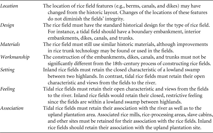
After identifying historic properties, the next step in the Section 106 process is to determine any effects on those properties. The intent of the General Permit is to avoid all adverse effects, defined as those effects that diminish the quality of the historic resource and may prevent it from being eligible for listing in the NRHP. In assessing effects, the USACE and the SCSHPO consider how potential actions can affect the historic integrity of the resource. The NRHP defines seven aspects of integrity, which are detailed in Table 1. This table also helps the plantation managers plan their work to avoid adversely affecting the rice fields. These expectations are laid out in the General Permit.
Assessing Integrity
The USACE’s General Permit addresses the need to identify historic rice fields and ensure that typical maintenance does not affect the integrity of the fields. All work permitted under a General Permit is not reviewed individually by the USACE, so the General Permit has a clear statement of work that is not authorized by the permit.Footnote 48 These activities, such as the reclamation of an abandoned rice field, may cause adverse effects to historic resources and require the consultation and scrutiny of a project that would occur under an Individual Permit.
The General Permit requires that all property owners who want to use the permit receive approval from the USACE and the SCSHPO prior to starting work. This “eligibility determination” is a series of steps and documentation that property owners must provide to qualify their rice fields for maintenance under the permit. Property owners must include the location of any known historic structures and archaeological sites photographed and marked on a map as part of the eligibility determination, thus providing the USACE and the SCSHPO with information on known historic properties in the project area.Footnote 49
CONSULTATION, COLLABORATION, AND CULTURAL LANDSCAPES
Consultation and collaboration led to increased understanding that rice fields are unique cultural resources with interconnected systems of land, water, vegetation, and wildlife. Although ecological features may be historic properties, they are rarely considered in standard Section 106 process. This project highlighted the interconnectedness of nature and culture in historic properties. It underscores the need for a more holistic perspective in identifying historic properties. Traditions in land use, construction methods, and social customs commonly evolved as people responded to the physiography and ecological systems of the area where they settled. The creation of rice fields was a response to the physiography and ecology of the South Carolina coast. Ecological studies may address hydrology, climate, patterns of vegetation, and biotic communities that have influenced land uses, vegetation, and responses to the environment, yet the cultural traditions of enslaved Africans and the European plantation owners are also significant aspects of rice field systems.
Section 106 requires consultation with impacted communities in order that local sentiment and economic realities be taken into consideration. Issues of race and class in preserving rice fields as cultural landscape cannot be ignored, given that the landscape has been shaped by the multiracial cultural heritage of the Lowcountry. Poor people, people of color, and others with little or no political clout have often experienced discrimination and manipulation in the hands of developers, realtors, and land-use planners. And mainstream conservationists, usually affluent white people, have often devoted less attention to the environmental issues affecting the poor groups living at the margins of social status and economic influence.Footnote 50 African Americans, especially those with multigenerational ties to the coastal region, have been greatly affected by the dynamics of residential and commercial growth and its impact on the natural environment. Conservation efforts that preserve large tracts of land can conflict with the livelihoods and folkways of indigenous people, especially with regard to access to traditional fishing locations or sweetgrass-gathering locations.Footnote 51 As a Black member of the City of Charleston’s planning staff explained, “it’s that you’ve never heard of a predominately European-American neighborhood being adversely affected by development at the scale and the number of instances that it happens to African-American communities.”Footnote 52 This can be seen in the creation of the ACE Basin where deeply embedded issues of race and class were sublimated through the overarching influence of white families in shaping the collaboration and structuring its elements. Almost half of the people living in the ACE Basin are low-income African Americans, yet they were underrepresented and, some would argue, underserved on the ACE Basin Task Force.Footnote 53
Although the development of the General Permit involved important aspects of collaboration, few African Americans, particularly the descendants of former slaves, were included in the Section 106 process. The turnout for public meetings was always large, and the USACE and the SCSHPO never questioned whether the participants were representative of the Lowcountry population. Whether these fields are currently important to African American communities is unknown. Despite the fact that these cultural landscapes have been in the hands of private landowners for hundreds of years, it is a huge flaw in the process in which important decisions were made about coastal South Carolina. Despite the lack of African American involvement in the ACE Basin Task Force, Halfacre indicates that the ecological result has been universally applauded: The basin remains one of the largest undeveloped estuaries on the Atlantic seaboard.Footnote 54 Similarly, the General Permit provides broad management and preservation of coastal cultural and natural resources.
The process of consultation and collaboration that resulted the examination and documentation of South Carolina’s cultural landscapes and the development of a General Permit can be a model for other projects. The broad management of cultural resources that have similar features provides predictability in cultural resource management and the applicability of national preservation laws to certain resources. While broad management practices have been applied to resources like historic bridges, this project shows that cultural landscapes are also historic properties that may benefit from a broad management approach.Footnote 55
Broad management encourages collaboration among a variety of disciplines. Cultural resource managers looking to structure this type of project should plan to step outside of the box of traditional history experts. The information from ecologists, biologists, archaeologists, and engineers came together to inform the USACE and SCSHPO’s application of preservation standards to the rice fields. The landowners and plantation managers themselves were fully invested in the project and provided land-use plans and guidance and as users of the cultural landscape are key stakeholders in the process. The rice plantation managers have a vested interest in maintaining fields, rather than reestablishing the wetland to a condition that existed prior to the construction of the fields. The SCSHPO also has a vested interest in the project because the continuous management of the fields ensured that important historic properties were protected and the historic practices of maintaining a rice field were never lost.
Incorporating ecology and cultural traditions in understanding rice fields involved open communication and a willingness to involve all interested stakeholders. The USACE cast a broad net by including stakeholders in the process, and the SCSHPO served as a voice for the historic character of the rice fields. In hindsight, additional work should have been done to identify African American stakeholders, including representatives from the Gullah Geechee Cultural Heritage Corridor. As part of this broad consultation effort, the USACE had firm support of its administration, including the district commander and the regulatory division chief. This enabled the district staff to spend time on this project, as the administration realized that time invested at the beginning of the General Permit would save time over the life of the permit.
Key time-saving initiatives placed in the General Permit include the assignment and definition of roles and responsibilities of all parties, a description of the type of data collection needed for each rice plantation pursuing work under the General Permit, and the development of standards to address the historic character and integrity of the rice fields. The USACE incorporated the information shown in Table 1 into the General Permit so that permittees would be aware up-front of the types of restrictions placed on their projects to minimize effects to historic properties. USACE also recognized the benefits of dividing the types of impacts that projects could pose to rice fields. All maintenance work and emergency stabilization is covered under the General Permit, while larger projects, such as reclamation of abandoned rice fields or removing water control structures from historic rice fields, deserve greater scrutiny and thus must undergo the Individual Permit process. Covering a broad category of maintenance projects under a General Permit streamlines the review of minor projects at the USACE, the SCSHPO, and all other resource agencies and saves the plantation owners and managers time and money.
CONCLUSION
Federal laws mandate the regulation of work within rice fields, since the fields are considered wetlands, and federal regulation brings a host of environmental laws into play, including historic property laws. While the SCSHPO is the state agency regarded as the expert in historic properties, information on the state’s cultural resources is not complete. Through the process of Section 106 consultation, the SCSHPO learned to identify historic features of rice fields, which led to informed decisions on the NRHP’s eligibility of rice fields and the predicted effects of maintenance work on historic fields, thus linking natural and cultural landscapes. Communication among the federal agency, the SCSHPO, and local groups and property owners was crucial in developing the General Permit for maintenance in the rice fields and in the identification of historic properties that may be affected by the permit.
The historic rice fields are cultural landscapes that preserve historical artifacts and land-based livelihoods. Since the process of Section 106 review moved from consultation to collaboration, the SCSHPO learned invaluable information from the plantation managers and local people and gained a better understanding of the workings of rice fields as cultural landscapes, a better grasp of the number of historic rice fields remaining in South Carolina, and experience in working with natural resources that are also cultural landscapes. The process of open communication and dialogue should be a model for decision making about other types of historic properties.
ACKNOWLEDGMENTS
The authors would like to thank Travis Folk, of Folk Land Management, for sharing his vast knowledge of rice fields, introducing us to plantation managers, and reading drafts of our Section 106 Guidance. We would also like to thank Andrew Agha, Charles Philips, and Josh Fletcher as well as U.S. Army Corps of Engineers project managers Tracy Dotolo Sanders, Mary Hope Green, and Paul Hinchcliff for sharing their knowledge of rice fields and managed tidal wetlands. Thanks also to the anonymous reviewers for their thoughtful comments on previous drafts.