As demonstrated by systematic archaeoastronomical research conducted in recent decades in Mesoamerica, including the Maya Lowlands (e.g., Aveni Reference Aveni2001; Aveni and Hartung Reference Aveni and Hartung1986, Reference Aveni, Hartung and Keber2000; Sánchez Nava and Šprajc Reference Sánchez Nava and Šprajc2015; Sánchez Nava et al. Reference Sánchez Nava, Šprajc and Hobel2016; Šprajc Reference Šprajc2018a, Reference Šprajc2021b; Šprajc and Sánchez Nava Reference Šprajc and Francisco Sánchez Nava2015; Šprajc et al. Reference Šprajc, Francisco Sánchez Nava and Cañas Ortiz2016, Reference Šprajc2023; Tichy Reference Tichy1991), the non-random distribution of architectural orientations can only be explained with the use of rising and setting points of celestial bodies as reference objects. Most orientations refer to sunrises and sunsets on specific dates, which concentrate in four agriculturally important seasons and tend to be separated by multiples of 13 and 20 days. The distribution of dates in the year and the contextual evidence, including ethnographic data, suggest that the solar orientations enabled the use of observational calendars that facilitated an efficient scheduling of agricultural and related ritual activities. Since the dates separated by multiples of 13/20 days shared the same number/sign of the 260-day calendrical cycle, it was relatively easy to predict the relevant dates, knowing the mechanics of the formal calendar and the structure of the observational scheme. This anticipatory aspect of observational calendars was very important, both because cloudy weather must have often hindered direct observations and because the ceremonies had to be prepared on time. Since the Mesoamericans employed no intercalation system that would have maintained (like our leap year rules) a permanent correlation between the calendrical (365-day) and the slightly longer tropical year, astronomical observations were necessary for keeping track of the seasons. However, they could have been carried out using simple equipment or horizon features; in fact, the so-called horizon calendars are considered to have been the most elementary form of precise observations of the Sun’s movement (Hartung Reference Hartung and Williamson1981:34; Reyman Reference Reyman and Aveni1975:213; Ruggles Reference Ruggles and Ruggles2015). Therefore, the astronomical alignments materialized in the built environment cannot be understood in purely utilitarian terms.
On the one hand, if the seemingly immutable and perfect order observed in the heavens—clearly surpassing that witnessed on Earth—served as the main reason for the divine status attributed to celestial bodies (Aveni Reference Aveni2003:150; Krupp Reference Krupp1983:62–81), then their cyclical patterns were not seen merely as coinciding with seasonal transformations in the natural environment, but as actively provoking them. If it was therefore believed that the timely occurrence of these changes was triggered by the arrival of celestial bodies at specific positions on the horizon, then architectural alignments replicating the directions to these events were likely intended, in accordance with principles of magical thinking, to ensure their regular recurrence.
On the other hand, it is noteworthy that accurate astronomical alignments in Mesoamerica were most consistently incorporated into monumental architecture. While the earliest examples, which appear to have been built by communities without clearly marked social inequality (Inomata et al. Reference Inomata, Fernandez-Diaz, Triadan, García Mollinedo, Pinzón, García Hernández, Flores, Sharpe, Beach, Hodgins, Durón Díaz, Guerra Luna, Guerrero Chávez, de Lourdes Hernández Jiménez and Moreno Díaz2021; Šprajc et al. Reference Šprajc, Inomata and Aveni2023), were likely designed by specialists holding more achievement-based than hereditary political authority, the situation changed with the development of social stratification. In complex societies, monumental religious, residential, and administrative buildings aligned with astronomical phenomena were largely commissioned by elites. This suggests that both the practical applications of astronomical knowledge and broader cosmological beliefs became integral to the ideology of power. As revealed by ethnohistorical sources, hieroglyphic texts, and iconography, rulers were directly concerned with astronomical matters (Aveni Reference Aveni2001:17–19; Reyes García Reference Reyes García and Dalhgren1979:37); moreover, they were closely associated with important deities and celestial bodies, and were also held responsible for maintaining the cosmic order (Grube Reference Grube, Blos, Cobos and Robertson2002:349; Houston and Stuart Reference Houston and Stuart1996; López Austin Reference López Austin1973; Martin Reference Martin2020:147-148; Stone Reference Stone and Fields1991:200; Šprajc Reference Šprajc1996:76–106, Reference Šprajc, Rappenglück, Rappenglück, Campion and Silva2016a). If, therefore, the proper timing of agricultural activities and accompanying ritual performances, crucial for sustaining the regular rhythm of natural cycles and ensuring plentiful harvests, was a prerogative and obligation of ruling elites, it contributed both to legitimizing their power and to strengthening the social cohesion needed to uphold the existing political order (Aveni and Hartung Reference Aveni and Hartung1986:56; Broda Reference Broda, Aveni and Urton1982:103–105; Iwaniszewski Reference Iwaniszewski and Aveni1989:30–31; Krupp Reference Krupp1997).
The present study examines architectural orientations and their potential astronomical significance in the El Palmar area. It should be pointed out that, while various cosmological concepts were involved in the ancient Maya architectural design and urban planning (e.g., Ashmore Reference Ashmore1991, Reference Ashmore, Golden and Borgstede2004; Ashmore and Sabloff Reference Ashmore and Sabloff2002, Reference Ashmore and Sabloff2003; Houk Reference Houk2017; Mathews and Garber Reference Mathews and Garber2004), our discussion is limited to astronomical principles embedded in architectural orientations. Since several structures have been at least partially excavated and consolidated (Ceballos Reference Ceballos2020; Tsukamoto Reference Tsukamoto and García2025, Reference Tsukamoto, Lamoureux-St-Hilaire and Canuto2026; Tsukamoto et al. Reference Tsukamoto, López Camacho, Evelia Campaña Valenzuela, Kotegawa and Olguín2015, Reference Tsukamoto, Evelia Campaña Valenzuela, Pesina, José Zamudio Gutiérrez, María Ramírez Hernández, García Hernández, Kotegawa, López Camacho, Arroyo, Salinas and Álvarez2018), we measured their orientations in the field. Many others, even if nowadays reduced to mounds, can be seen on relief models derived from airborne laser scanning (ALS, lidar) conducted in 2017 by J. C. Fernandez-Diaz, of the National Center for Airborne Laser Mapping (NCALM) at the University of Houston (Hernández Gómez Reference Hernández Gómez2021; Tsukamoto et al. Reference Tsukamoto, López Camacho, Fernandez-Diaz, Shrestha, Hernández Gómez, Jiménez Delgado, López Mejía, Chase, Flores, Stanton, Houston, Schroder and Tsukamoto2026). The lidar mapping covered an area of 94 km2 in and around El Palmar’s civic core or the Main Group. As exemplified by some previous studies (Šprajc Reference Šprajc2021a, Reference Šprajc2021b; Šprajc et al. Reference Šprajc, Inomata and Aveni2023), the orientations of many pre-Hispanic structures can be measured with reasonable precision on lidar data. Also in the case of El Palmar, it was possible to determine the orientations of many unexcavated structures on the lidar-derived digital elevation model, using different types of visualizations and ESRI ArcGIS software.
Archaeological research in the El Palmar area
The archaeological site of El Palmar, located on the eastern edge of the Central Karstic Uplands in southeastern Campeche, Mexico (Figure 1), consists of the Main Group and several outlying architectural groups (Figure 2). Since 2007, when Kenichiro Tsukamoto and Javier López Camacho initiated the Proyecto Arqueológico El Palmar (PAEP), the project team has conducted surface surveys based on airborne lidar mapping, ground verifications and topographic mapping, surface collections, horizontal and stratigraphic excavations, and artifactual analyses. The lidar survey, encompassing 94 km2, uncovered over 10,000 structures forming more than 500 plazas and plazuelas (i.e., small plaza compounds).
Map representing the location of El Palmar and other Maya sites.

Lidar-derived map of the El Palmar area.

The Main Group is composed of eight plazas, two large pyramidal structures (Temples I and II), a palace complex, a ballcourt, reservoirs, and about a hundred structures with administrative, religious, and residential functions. Temples I and II flank a central reservoir (Central Aguada) at its north and south ends. The Great Plaza and Plaza E, which stand out as large public spaces, are complemented by several medium-sized plazas (Figure 3). Stratigraphic excavations took place at these plazas, establishing a general site chronology that spans from the Late Preclassic (ca. 300 b.c.–a.d.250) to the Terminal Classic period (ca. a.d. 800–950).
Lidar-derived map of the Main Group of El Palmar, with names of structures and complexes mentioned in the text (visualizations in Figures 3, 6, and 7 were generated with Relief Visualization Toolbox, using hillshading from multiple directions; Kokalj et al. Reference Kokalj, Zakšek, Oštir, Pehani, Čotar and Somrak2019).

The Great Plaza is the largest public space at El Palmar. Excavations and ceramic analyses indicate that this place was paved for public gathering by a.d. 600. Structure PM8, a massive range structure oriented in an east–west direction, closes the plaza’s north end while Temple I delineates its southern edge. El Palmar kings commissioned several stone monuments on the Great Plaza during the Late Classic, with the earliest legible monument being Stela 10, erected in a.d. 711. The latest monument on the plaza is Stela 16, which dates to a.d. 800 and was placed near the southeast corner of Structure PM8. The second largest plaza is Plaza E located to the west of Temple I. Excavations in Plaza E uncovered three floors, of which the earliest one was paved by a.d. 600. At the south end of the plaza stands Structure PM6, a large range structure oriented in an east–west direction.
To the west of Plaza E lies a palace complex that served as the access point to Plaza G. This exclusive space, located 10 m above the ground surface of Plaza E, is enclosed by structures on its east (Structure S21-3), north (S22-1), and south ends (S21-2), effectively making activities in Plaza G invisible from Plaza E. The west side supports the third largest structure (S21-1) at El Palmar. Structure S21-1 measures approximately 40 by 30 m at its base and stands 10 m tall. During the 2022 field season, the PAEP carried out horizontal and stratigraphic excavations at Structure S21-1 (Figure 4). These excavations exposed five rooms and four platforms. Although the horizontal excavations have not yet fully uncovered the north rooms of the structure, its mound shape suggests that Structure S21-1 consisted of seven or more rooms flanked by massive buildings. Room 3, located at the center of the structure, has a large masonry throne that measures 4 m in width. A doorway in front of the throne provides a line of sight to the entrance of Structure S21-3, which marks the eastern boundary of Plaza G. The results of ceramic analyses and radiocarbon dates suggest that Structure S21-1 was built during the first half of the Late Classic period (ca. a.d. 600–720), with several renovations extending into the Terminal Classic period (a.d. 800–950). Among these renovations, Room 3 was probably remodeled along with the throne around a.d. 770.
Structure S21-1 after excavations, looking northwest.

In addition, there is an internal stairway that leads to the roof. A platform or terrace in front of the rooms features a short staircase with three steps descending to another platform, which is divided into three sections by two walls that abut the stairway. These three platforms were originally attached to another large staircase leading to Plaza G. However, this staircase seems to have been dismantled, most likely during a termination ritual (ca. a.d. 800–950). On-floor assemblages of the termination ritual contained royal relics such as a plate with royal titles, a bone needle with a pop (i.e., mat) sign, sophisticated ornaments for women, and several complete or semi-complete bowls and vases. These artifacts, together with the structure’s characteristics mentioned above, suggest that Structure S21-1 was occupied by royal families.
The stratigraphic excavations uncovered a substructure (Structure S21-1-sub). The three platforms mentioned above were built by razing the substructure’s roof comb, below which the excavations found vaulted rooms. The dismantling of the staircase as a termination ritual partially exposed the substructure’s east façade, which was decorated with three mascarones. The north mascarón, which was partially exposed, still preserved its stucco decorations that represent a human face with square earflares while the south one was almost completely eroded. The central mascarón only preserves its armature whose nose is aligned with the central axis of the three platforms.
Two radiocarbon assays associated with the substructure’s floor dated to cal a.d. 391–548. Among ceramic sherds recovered from the substructure’s construction fill, Tsukamoto sorted Aguila Orange: Flamboyan, a type-variety that corresponds to the Sabucan Ceramic Complex (a.d. 450–630) (Ball Reference Ball1977).
To the south of the Central Aguada is the K’awiil Plaza. Monumental structures, including Temple II, form this plaza where seven stelae and an altar were placed from a.d. 554 to 884. An El Palmar ruler, K’ahk’ P’ulaj Chan Yopaat, ordered the placement of a round altar (Altar 10) in front of Temple II on 9.6.0.0.0 (March 23, a.d. 554) as the period-ending ceremony of the sixth K’atun. Structure PM33, which consists of three pyramidal structures on a platform, closes the south end of the plaza. At the bottom of the plaza, a stratigraphic excavation exposed an elaborate platform that dates to 51 cal b.c.–cal a.d. 63.
PAEP also carried out substantial excavations at an outlier named the Guzmán Group, which is situated 1.3 km north of the Main Group. It consists of a plazuela, an enclosed patio to the northwest, and isolated buildings (Figure 5). The plazuela is composed of an eastern temple with a hieroglyphic stairway named Structure GZ1 and several range structures. According to the inscriptions carved on the stairway, a social group holding a title of lakam, “banner,” occupied this plazuela group (Tsukamoto et al. Reference Tsukamoto, López Camacho, Evelia Campaña Valenzuela, Kotegawa and Olguín2015). The hieroglyphic staircase consists of six steps whose texts are read from bottom to top. The first five steps depict a journey of Ajpach’ Waal, the protagonist of the stairway, to meet the thirteenth ruler of the Copán kingdom, Waxaklajuun Ubaah K’awiil, on June 29, a.d. 726. In the text, Ajpach’ Waal claims that he is a descendant of lakam officials or standard-bearers, listing his ancestors together with their El Palmar kings. The text suggests that Ajpach’ Waal played the role of ambassador in negotiating political alliances between the Snake dynasty (Calakmul) and Copán through El Palmar (Tsukamoto and Esparza Olguín Reference Tsukamoto, Olguín, Golden, Houston and Skidmore2015; see also Tsukamoto Reference Tsukamoto, Tsukamoto and Inomata2014b). The sixth step depicts a series of Ajaw signs together with numbers. Some blocks are heavily eroded, but the numbers probably go from 13 to 1, comprising a calendrical sequence of 10 Tun cycle associated with the tzolk’in day of Ajaw. Elsewhere, Tsukamoto and Esparza Olguín (Reference Tsukamoto, Olguín, Golden, Houston and Skidmore2015:52) proposed that Ajpach’ Waal and/or standard-bearers played priestly or timekeeper roles in charge of the calendrical system, although there is no other evidence to support this hypothesis. To the northwest of the plaza is a patio dominated by Structure GZ7. Horizontal and stratigraphic excavations took place at Structures GZ1, GZ3, GZ5, GZ6, GZ7, GZ9, and the plazuela.
Map of the Guzmán Group, with contours generated from the lidar-derived relief (survey and drawing of ground plans of structures by PAEP).

Structure GZ1-sub 1 was built with a modest staircase between a.d. 646 and 726 (Tsukamoto et al. Reference Tsukamoto, Tokanai, Moriya and Nasu2020). A hieroglyphic stairway was attached to the temple in a.d. 726 (Tsukamoto et al. Reference Tsukamoto, López Camacho, Evelia Campaña Valenzuela, Kotegawa and Olguín2015). Around the same time, the plazuela was paved by razing and burying the scattered houses to create a public gathering space. Structure GZ3 is a range structure, closing the south end of the plazuela (Ceballos Reference Ceballos2020; Tsukamoto et al. Reference Tsukamoto, Evelia Campaña Valenzuela, Pesina, José Zamudio Gutiérrez, María Ramírez Hernández, García Hernández, Kotegawa, López Camacho, Arroyo, Salinas and Álvarez2018). It contains two rooms, each of which has an entrance and a masonry bench. Twenty-three radiocarbon assays together with ceramic analyses suggest that Structure GZ3 was built in cal a.d. 720–770, remodeled during the Late-Terminal Classic, and abandoned around a.d. 880 (Tsukamoto et al. Reference Tsukamoto, Tokanai, Moriya and Nasu2020:1257). Structure GZ5 is also a range structure with five entrances, marking the northwest boundary of the plaza. Stratigraphic excavations and subsequent analyses suggest that GZ5 was built in cal a.d. 720–740 and abandoned around a.d. 880 (Tsukamoto et al. Reference Tsukamoto, Tokanai, Moriya and Nasu2020:1260). Structure GZ6, which forms the north limit of the plazuela, consists of three rooms; the west room contains two masonry benches probably used for private and public activities, while the central room is a small space that was possibly used as a storage room. The latest floor was paved between cal a.d. 694 and 753. Horizontal and stratigraphic excavations at Structure GZ9 exposed two rooms with masonry benches built between cal a.d. 669 and 777. Material remains suggest that standard-bearers used this building for food preparation.
In addition, PAEP detected an elaborate residential complex that was probably occupied by the leaders of standard-bearers. It is located northwest of the plazuela and dominated by Structure GZ7. In 2019, we excavated this structure horizontally and stratigraphically, uncovering six rooms and partially exposing a stairway. There are three doorways on the west side of the building, and each doorway has access to two rooms. Each pair of rooms contained a stone bench, possibly for meeting and receiving visitors (Harrison Reference Harrison, Inomata and Houston2001; Inomata et al. Reference Inomata, Triadan, Ponciano, Pinto, Terry and Eberl2002). The horizontal excavations yielded on-floor assemblages including serving bowls, jars, metates, and manos. Structure GZ7 was built between cal a.d. 670 and 774 (Tsukamoto Reference Tsukamoto, Lamoureux-St-Hilaire and Canuto2026).
Two other architectural groups are associated with this study. The Justo Group, located 500 m west of the Main Group, has two plazas enclosed by pyramidal and range structures. The one relevant to this study is Plaza A, composed of a pyramidal temple (Structure JT1) and six other structures (Figure 6). PAEP conducted a test excavation at the foot of JT1, exposing three floors that date to the Late-Terminal Classic period (ca. a.d. 720–950). The other architectural group is the Hernández Group, which is located 1.6 km northeast of the Main Group. The lidar images show that the Hernández Group consists of two plazas with long aligned buildings arranged in quadrangles, alleyways, a ballcourt, a temple structure, and other types of buildings (Tsukamoto et al. Reference Tsukamoto, López Camacho, Fernandez-Diaz, Shrestha, Hernández Gómez, Jiménez Delgado, López Mejía, Chase, Flores, Stanton, Houston, Schroder and Tsukamoto2026). An isolated structure (W23-50) is located about 150 m to the northeast (Figure 7). Two tall mounds are connected via a narrow range structure, an architectural arrangement reminiscent of Río Bec-style twin towers, although the relationship between El Palmar and the Río Bec region remains unknown. In 2018, PAEP conducted a test excavation at the southwest edge of the structure, exposing a single floor, although its plaster was completely weathered. Ceramic analyses suggest that the floor was paved during the Late Classic period (a.d. 600–800).
Lidar-derived map of Plaza A at the Justo Group.

Lidar-derived map of the Hernández Group.

Measurements and data reduction
Considering that previous systematic studies have revealed the unlikelihood of astronomical functionality of north–south lines (Aveni and Hartung Reference Aveni and Hartung1986:60, Reference Aveni, Hartung and Keber2000:55; Šprajc Reference Šprajc2001:25–26, Reference Šprajc2018a:205), only east–west alignments were determined for this study. Only for a few major structures, listed in Table 1 and shown in Figures 3 to 7, could the orientations be determined with sufficient precision. The alignments incorporated in Structures S21-1 of Plaza G at the Main Group and Structures GZ1, GZ3 GZ5, GZ7 at the Guzmán Group were measured in the field with a theodolite and astronomical reference, employing standard archaeoastronomical measurement techniques (Aveni Reference Aveni2001; Ruggles Reference Ruggles1999). Other orientations listed in Table 1 were measured on lidar data, tracing lines along the elongated parts of structures. The azimuths of these lines in Universal Transverse Mercator (UTM) cartographic projection were corrected to true (astronomical) azimuths for grid convergence, calculated with ArcGIS tools. Each azimuth was assigned an estimated error, based on the current condition of the building’s walls and faces or on uncertainties arising from the resolution of lidar data. The orientation of Plaza A at the Justo Group is represented by the azimuth of the line connecting Structures JT1 and JT5; that this alignment (which may well have been observationally functional) represents the intended orientation of the group is suggested by the lateral elongated structures (Figure 6).
Data on orientations of major buildings at El Palmar

Note: All angular values are in decimal degrees. (A) azimuth; (A error) estimated error of azimuth; (HE) altitude of east horizon; (HW) altitude of west horizon; (δE) declination east; (δW) declination west; (intv.) interval.
Taking readings in the field, we measured wherever possible the alignment that would have been most likely used for observations. On Structure S21-1, facing east, the theodolite was placed on the midpoint of the doorway of the central chamber with the throne (Room 3) and three slightly different alignments were measured (Figures 8 and 9): to the midpoint of the recessed space of Room 3 (A1); to the midpoint between the two walls abutted to the stairway in front of Structure S21-1 (A2); to the midpoint of the main entrance of Structure S21-3 (A3). In the Guzmán Group, the orientations of Structures GZ6 and GZ9 were not determined because they have notably divergent east–west walls, without any structural feature suggesting that any of them was more important than any other. It is thus unlikely that an astronomically motivated intent was involved in their layout. Readings were taken only in Structures GZ1, GZ3, GZ5, and GZ7. On Structure GZ1, no clearly marked east–west alignment is preserved; in Table 1, the mean value of azimuths measured along several east–west lines is given. The orientation of Structure GZ3 was measured along its front facing north. Structure GZ5 is a building elongated in the north–south direction and with a single row of rooms, thus lacking a clear east–west alignment; its orientation was measured along its east-facing front, and the azimuth in Table 1 corresponds to the perpendicular to this line. The azimuth of Structure GZ7 corresponds to its central axis of symmetry defined by two pairs of jambs.
Ground plan of Structure S21-1 (survey and drawing by PAEP), with the alignments measured in the field.

Map of the Plaza G complex, with alignment A3 and contours generated from the lidar-derived digital elevation model (contour interval: 0.5 m).

For the orientations listed in Table 1, the astronomical referents were determined. Putative astronomical target(s) of an alignment can only be identified by calculating the corresponding declination (celestial coordinate expressing angular distance measured from the celestial equator to the north and south and depending on the azimuth of the alignment, geographic latitude of the observer, and the horizon altitude corrected for atmospheric refraction). The declinations were calculated with the formulae of spherical astronomy routinely used in archaeoastronomical research (Aveni Reference Aveni2001; Ruggles Reference Ruggles1999; Šprajc and Sánchez Nava Reference Šprajc and Francisco Sánchez Nava2015). Horizon altitudes were calculated with the aid of a lidar-derived digital elevation model; if the horizon line was found to be beyond the coverage of lidar data, they were calculated with the Horizon software (http://www.agksmith.net/horizon/), using 1 arc-second (30 m) SRTM (Shuttle Radar Topography Mission) data (https://www.earthdata.nasa.gov/data/instruments/srtm). In these calculations, the height of forest canopy was considered to have been 15 m, except in the area of clearance surrounding the observation point within a radius of 3,000 m. The errors resulting from this inevitably arbitrary decision are small and probably negligible because the horizon line is in most cases several kilometers away.
Since all the declinations listed in Table 1 are within the solar span, the corresponding sunrise and sunset dates were determined. The intervening intervals were also calculated, considering their importance revealed by previous research. Since the Sun attains a certain declination (except a solstitial one) twice a year, two sunrise and two sunset dates correspond to each alignment and each date pair divides the year into two intervals, whose sum is equal to the length of the tropical year (currently about 365.2422 days). The dates are given in the proleptic Gregorian calendar (extrapolated into the past before its actual introduction), which is the closest approximation to the tropical year. Due to secular variations in Earth’s orbital elements and in the Gregorian calendar intercalation system, one and the same solar declination does not always correspond to exactly the same Gregorian date. The buildings involved were most likely built in the Late Classic period, as suggested by the dating of Structures S21-1 (a.d. 600–720), GZ1 (a.d. 726), GZ3 (a.d. 720–770), GZ5 (a.d. 720–740), GZ7 (a.d. 670–774), and GZ9 (a.d. 669–777). Therefore, Julian year a.d. 700 was chosen for calculating the dates and intervals, as well as their possible errors based on estimated errors of azimuths. For that year, solar ephemeris data were generated, employing the Horizons Web-Interface provided by the Solar System Dynamics Group of the NASA Jet Propulsion Laboratory (https://ssd.jpl.nasa.gov/horizons/). It should be noted that the dates and intervals as well as their errors were calculated precisely, with fractions of days, but date fractions are not shown in Table 1 (for details of the computation procedure and arguments justifying it, see Sánchez Nava and Šprajc Reference Sánchez Nava and Šprajc2015:29–31; Šprajc Reference Šprajc2021a:8–11; Šprajc et al. Reference Šprajc, Inomata and Aveni2023). The results would not be affected in any notable way by the exact dating of individual structures because the relationship of certain declinations and dates does not change perceptibly over a few decades.
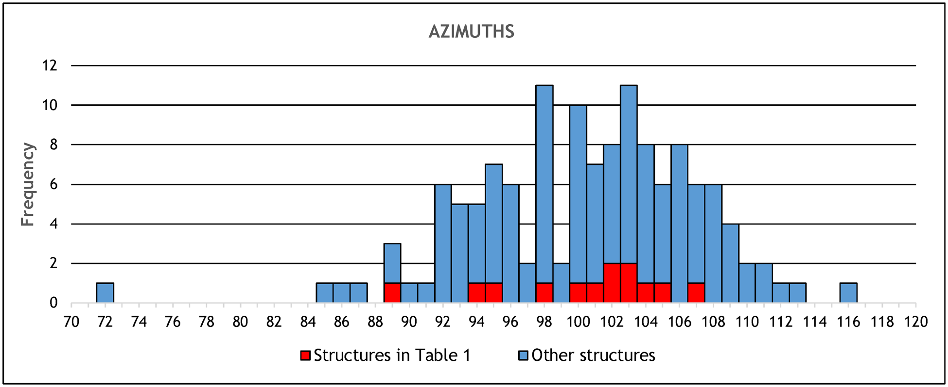
In addition to the orientations listed in Table 1, it was possible to measure 121 orientations on lidar data. However, their astronomical referents have not been determined, both because the azimuths cannot be measured with sufficient precision and because it seems little likely that the corresponding structures, given their characteristics and minor sizes, were designed to be astronomically functional. These orientations were measured to verify whether or to what extent they are similar to those of the structures listed in Table 1, which were more likely observationally functional. The distributions of azimuths, indeed, exhibit some similarities, which will be discussed below.
Astronomical referents of orientations
The significance of orientations at El Palmar can be interpreted in terms of the known orientation patterns in the Maya Lowlands and elsewhere in Mesoamerica. The orientations listed in Table 1 are all within the arc of annual movement of the Sun along the horizon. As already mentioned, the dates marked by solar orientations in Mesoamerica concentrate in agriculturally significant seasons; since they also delimit intervals that tend to be multiples of 13 or 20 days, they most likely marked canonical, ritually important dates in the agricultural cycle.
As no such intervals are marked by the alignment A1 measured on Structure S21-1, it does not seem to have been based on astronomical criteria. Another fact supporting this opinion is that, since the central Room 3 faces east, the alignment A1 would have expectedly been functional in that direction, but this room with the throne was likely a private place not appropriate for observations from its interior (Figures 4 and 8). The alignment that must have been observationally functional is A2, which corresponds to sunrises on February 19 and October 22, separated by an interval of 120 (= 6 × 20) days. The sunrises on these dates were marked by one of the prominent orientation groups in the Maya Lowlands (Sánchez Nava and Šprajc Reference Sánchez Nava and Šprajc2015:75; Šprajc Reference Šprajc2021a). Significantly, the same orientation is also materialized in Structure GZ3 at El Palmar (Table 1). Yet another and slightly different alignment on Structure S21-1 is A3, measured to the midpoint of the central entrance of Structure S21-3 (Figure 9). It may have also been intentional because it corresponds to sunrises on February 24 and October 17, separated by almost precisely 130 (= 10 × 13) days. This orientation group is common in the Maya Lowlands and one of the earliest in Mesoamerica (Sánchez Nava and Šprajc Reference Sánchez Nava and Šprajc2015:80; Šprajc et al. Reference Šprajc, Inomata and Aveni2023; Šprajc and Inomata Reference Šprajc and Inomata2024).
It should be noted that the alignment A2 passes over the midpoint between two walls abutted to the stairway (Figure 8), but this midpoint seems to be exactly above the center of the central mascarón on the east façade of Structure S21-1-sub that dates to cal a.d. 391–548. It is thus possible that A2 was already important at that time, although a different observation point would have been used. However, since the two walls, which appear to be remnants of Structure S21-1-sub’s roof comb or were built along with it, were preserved (at least in part) when the latter was covered by Structure S21-1 (ca. a.d. 600–720), their purpose may have been to mark the same alignment, which thus may have still been important in the early stage of the Late Classic. However, when Room 3 with the throne was built (ca. a.d. 720–770), the two walls, if not substantially higher, may have become poor markers of the alignment for an observer positioned at the doorway of that room. If so, at some moment the use of the alignment A2 may have been abandoned and replaced by the alignment A3. The latter seems to be parallel to the rows of mounds on the northern and southern range structures (S21-2 and S21-4) of Plaza G (Figure 9). This could mean that the structures enclosing Plaza G’s north, east, and south sides were built during the Late Classic period.
Other structures in the Main Group have not been excavated and have no exposed architectural elements; the orientations of those listed in Table 1 were determined on lidar data. The estimated error of Temple I’s azimuth is relatively large, but it seems that the temple faced sunrises on March 11 and October 2, with an intermediate interval of 160 (= 8 × 20) days. The orientation group marking these dates is widely spread in the Maya Lowlands (Sánchez Nava and Šprajc Reference Sánchez Nava and Šprajc2015:84; Šprajc Reference Šprajc2021a, Reference Šprajc2021b) as well as along the southern Gulf Coast (Šprajc et al. Reference Šprajc, Inomata and Aveni2023).
The elongated Structure PM8 may have recorded sunrises on quarter days. These dates (March 23 and September 21, ± 1 day), falling two days after/before the vernal/fall equinox, divide each half of the year delimited by the solstices into two equal parts of approximately 91 (= 7 × 13) days. While the orientations marking these dates are very common throughout Mesoamerica (Šprajc Reference Šprajc2018a; Šprajc et al. Reference Šprajc, Inomata and Aveni2023), there is no compelling evidence that the Mesoamericans were aware of the equinoxes (Šprajc Reference Šprajc2023).
Structure PM33, which closes the K’awiil Plaza’s south end, was very likely oriented to sunrises on February 12 and October 30, separated by an interval of 260 days. The orientation of Structure PM6 at the south boundary of Plaza E is almost the same, but it could have been functional to the east only if it is earlier than the platform with Plaza H, which currently blocks the view to the horizon. The orientations pertaining to this group predominate in the Maya Lowlands (Sánchez Nava and Šprajc Reference Sánchez Nava and Šprajc2015:77–79, tabla 8; Šprajc Reference Šprajc2021a, Reference Šprajc2021b) but are also widespread elsewhere in Mesoamerica (Šprajc Reference Šprajc2001, Reference Šprajc2018a), most likely because they marked an interval that equals the length of the ritual calendrical cycle. The earliest constructions pertaining to this orientation group appeared during the Early to Middle Preclassic transition in the area along the southern coast of the Gulf of Mexico (Šprajc et al. Reference Šprajc, Inomata and Aveni2023; Šprajc and Inomata Reference Šprajc and Inomata2024).
The buildings at the Guzmán Group, measured in the field, are of modest sizes (Figure 5) (Tsukamoto et al. Reference Tsukamoto, López Camacho, Evelia Campaña Valenzuela, Kotegawa and Olguín2015, Reference Tsukamoto, Evelia Campaña Valenzuela, Pesina, José Zamudio Gutiérrez, María Ramírez Hernández, García Hernández, Kotegawa, López Camacho, Arroyo, Salinas and Álvarez2018; Tsukamoto Reference Tsukamoto, Lamoureux-St-Hilaire and Canuto2026) and probably not all of them were oriented astronomically. The intended orientation of Structure GZ1, which faces west and had a hieroglyphic stairway (Tsukamoto and Esparza Olguín Reference Tsukamoto, Olguín, Golden, Houston and Skidmore2015), cannot be accurately determined, but it may have recorded sunsets on May 7 and August 6, separated by 91 (= 7 × 13) days. Several Maya buildings face sunsets on these dates, most accurately the Upper Temple of the Jaguars at Chichén Itzá (Sánchez Nava and Šprajc Reference Sánchez Nava and Šprajc2015; Šprajc and Sánchez Nava Reference Šprajc and Nava2013). Structure GZ3 was aligned to sunrises on February 19 and October 22, probably on purpose, considering that these dates also match the alignment A2 in Structure S21-1 (vide supra). Structure GZ5 does not seem to have been oriented on astronomical grounds. It has no evident architectural elements that would have facilitated observations, and the view to the east was probably blocked by the structures on the eastern flank of the plaza. Structure GZ7, facing west, may have marked sunsets delimited by either a 120-day or a 240-day interval, but only if the azimuth error is at least ±0.5°. Such an error is unlikely because the azimuth of its central axis of symmetry, defined by two pairs of jambs, could be measured quite precisely. Since the alignment data do not correspond to any of the orientation groups identified in the Maya Lowlands, this building does not seem to have been laid out on astronomical grounds. As mentioned above, Structures GZ6 and GZ9 have divergent east–west walls and their orientations cannot be reliably determined.
Plaza A of the Justo Group, lying about 800 m west of the site core (Tsukamoto Reference Tsukamoto2014a:146–150), must have been oriented to sunrises on February 22 and October 20, with an intermediate interval of 240 (= 12 × 20) days. The buildings marking these dates belong to one of the most prominent orientation groups in the Maya Lowlands (Sánchez Nava and Šprajc Reference Sánchez Nava and Šprajc2015:79–80, tabla 9; Šprajc Reference Šprajc2021a, Reference Šprajc2021b).
Structure W23-50 near the Hernández Group was probably oriented to sunsets on April 3 and September 10, separated by 160 (= 8 × 20) days and recorded by various orientations in the Maya Lowlands (Sánchez Nava and Šprajc Reference Sánchez Nava and Šprajc2015:73–74, tabla 7; Šprajc Reference Šprajc2021a, Reference Šprajc2021b).
In sum, several architectural orientations at El Palmar that can be determined with reasonable confidence most likely marked the Sun’s positions on the horizon on certain dates, because they belong to formerly identified orientation groups in the Maya Lowlands, which marked the same dates and calendrically significant intervals. This conclusion is supported by the orientations of additional 121 structures measured on lidar data. As Figure 10 shows, their azimuths exhibit a non-uniform distribution; the concentrations around certain azimuths, which also correspond to the orientations for which the astronomical referents were determined (Table 1), suggest that at least some of the minor structures were based on the same criteria. Although the possible astronomical referents of minor structures were not calculated, the azimuths are sufficiently indicative because the horizon altitudes in the El Palmar area are very small and thus the same or similar azimuths within the solar span correspond to almost the same dates.
Frequency distribution of east–west azimuths of structures in the El Palmar area.

However, the relatively dispersed distribution of azimuths of minor structures suggests that most of these orientations, rather than being based on astronomical observations, only approximately reproduced the astronomically functional orientations of major buildings. The El Palmar area is but one example of what must have been a common practice in Mesoamerica, including the Maya Lowlands. As shown by several similar situations discussed elsewhere (Šprajc Reference Šprajc, González-García, Frank, Sims, Rappenglück, Zotti, Juan Belmonte and Šprajc2021c), the astronomically significant directions, incorporated into temples, elite residences, and administrative palaces, were often replicated, albeit approximately and without being observationally functional, by the adjacent buildings, sometimes by entire urban plans and even by substantial parts of the surrounding cultural landscapes. The urban layouts of Teotihuacan, Tenochtitlan, and La Campana were laid out in conformity with the orientations of the most important buildings (Šprajc Reference Šprajc2000a, Reference Šprajc2000b; Šprajc et al. Reference Šprajc, Francisco Sánchez Nava and Cañas Ortiz2016:33). In the area of Chactún in eastern Campeche, the distribution of orientations of a large number of modest structures, with major concentrations around azimuths of 100° and 105°, is similar to that of orientations of major civic and ceremonial buildings measured in the Maya area, including those at Chactún, Tamchén, and Lagunita (Šprajc Reference Šprajc, González-García, Frank, Sims, Rappenglück, Zotti, Juan Belmonte and Šprajc2021c:Figure 19.1, Reference Šprajc2021d:35–36). At Cantona, Puebla, the solstitial orientation of the Central Pyramid, one of the earliest buildings at the site, is roughly reproduced by numerous residential compounds in the surrounding area (Šprajc and Sánchez Nava Reference Šprajc and Francisco Sánchez Nava2015:54–55). As a survival from pre-Hispanic times, approximate solstitial directions are also materialized in urban grids and fields in the Puebla-Tlaxcala basin (Tichy Reference Tichy1991:Figure 6-13)—where they must have been inspired by the orientation of Cholula’s main pyramid—and in the Tlacolula valley, Oaxaca (Faulseit Reference Faulseit, Dowd and Milbrath2015; Storck Reference Storck1980), where their pre-Hispanic importance is attested at Caballito Blanco, Yagul, Lambityeco, and Dainzú-Macuilxóchitl (Šprajc and Sánchez Nava Reference Šprajc and Francisco Sánchez Nava2015). These cases, including El Palmar, make it clear that a general conformity to the astronomically significant directions was an important factor in laying out even buildings that had no major role in public life.
An additional fact reflecting the importance of astronomical criteria and related cosmological concepts in the El Palmar area is the predominant clockwise skew of orientations from cardinal directions (Figure 10). The south-of-east/north-of-west deviation is a prevalent characteristic of Mesoamerican architectural orientations, most likely derived from the symbolism of world directions. The solar orientations with this skew marked sunrises and sunsets on dates that fell mostly in the dry and wet seasons, respectively, and this is what the builders apparently wanted to achieve. As evidenced by pre-Hispanic and early colonial iconography and written sources, as well as by ethnographic survivals, the dry season was conceptually related to the eastern part of the universe and the rainy season to the western part. Particularly revealing are the symbolism and directional associations of the Sun, Moon, and Venus: the Sun, presiding in the east, was related to heat, fire, and drought, whereas the Moon and Venus, primarily its evening manifestation, were associated with the west, as well as with water, maize, and fertility (Broda Reference Broda, Aveni and Brotherston1983:156–157; Lehmann Reference Lehmann1928:766–772; Šprajc Reference Šprajc2004, Reference Šprajc2018b; Thompson Reference Thompson and Eric1971:112).
Practical uses and ritual significance of orientations in the El Palmar area
Based on the contents of pre-Hispanic codices, Aveni and Hartung (Reference Aveni and Hartung1986:56) argued long ago that an important function of the Maya calendar was “the formalization of ritual relating to agriculture” and “consequently, we would expect that any dates we might extract from a hypothetical orientation calendar would have agricultural significance.” Subsequent systematic studies of a large number of orientations in Mesoamerica have confirmed this assumption. Ethnographic and ethnohistorical data additionally support the ceremonial, agriculturally related significance of dates recorded by solar alignments and of the intervening intervals. While exhaustive discussions to this effect have been presented elsewhere (Sánchez Nava and Šprajc Reference Sánchez Nava and Šprajc2015; Šprajc Reference Šprajc2001, Reference Šprajc2018a; Šprajc and Sánchez Nava Reference Šprajc and Francisco Sánchez Nava2015; Šprajc et al. Reference Šprajc, Francisco Sánchez Nava and Cañas Ortiz2016), here we will focus on the dates marked specifically by orientations at El Palmar. It should be recalled that most orientations were functional only in one direction, recording dates separated by multiples of 13 or 20 days. As shown in a previous study (González-García and Šprajc Reference González-García and Šprajc2016), the most evident concentrations of dates and calendrically significant intervals marked by orientations in the Maya Lowlands have statistical significances above the 3-sigma level. Based on these findings, it was possible to propose the most likely directionality of orientations at El Palmar and the intentionally recorded dates (vide supra).
Like elsewhere, the dates most likely marked by El Palmar structures concentrate in four seasons important in the maize cultivation cycle. The dates in February, when land plots are cleared, and October, when the rainy season ends and harvest of maize begins, thus approximately delimited the agricultural cycle. Particularly important dates must have been February 12 and October 30, which were marked by one of the most widespread orientation groups in Mesoamerica. Accordingly, Structures PM33 and PM6, and apparently a number of other structures in the El Palmar area whose azimuths cluster around 104° (Figure 10), belong to this orientation group. An agricultural explanation for the orientations to sunrises on February 12 and October 30 is strongly supported by the ethnographically documented ritual significance of nearby dates. The Tzotzil Maya of San Pedro Chenalhó in Chiapas start and end their agricultural year with two crop rituals performed on February 14 and November 6 (Guiteras-Holmes Reference Guiteras-Holmes1961:33-34). The native calendrical year of the Chinantecs in Oaxaca starts on February 10 (Weitlaner Reference Weitlaner1936). According to the early 20th-century reports, the Maya of San Antonio, Belize, and the Chortí of Guatemala began their agricultural year on February 8 (Girard Reference Girard1949:411–435; Thompson Reference Thompson and Eric1930:41–43). Since these dates do not correspond to Christian feasts, their pre-Hispanic roots are hardly disputable.
More often, however, the ancient ceremonies performed at key moments of the annual cycle were incorporated into the approximately coincident Catholic festivals, whose agricultural symbolism has evident pre-Hispanic origins (Broda Reference Broda2003; Bassie-Sweet Reference Bassie-Sweet2008:40–42; Thompson Reference Thompson and Eric1930:55; Wisdom Reference Wisdom1940:437). Crucial events in many communities are the feasts of Candelaria (February 2), which marks the beginning of the agricultural cycle and commonly includes the blessing of seeds, and the rituals of Todos los Santos y Fieles Difuntos (October 31 to November 4), which often include thanksgiving ceremonies at the end of the rainy season and cultivation cycle (Broda Reference Broda2003; Jiménez Castillo Reference Jiménez Castillo1992:Anexo 3; Neuenswander Reference Neuenswander1981:146; Quiñones and Quintal Reference Quiñones Vega and Avilés2002; Quintal and Rejón Reference Quintal Avilés and Rejón Patrón2005).
A comparable significance can be attributed to a few other dates in Table 1, which delimit calendrically significant intervals and were marked by important orientation groups in the Maya Lowlands (Sánchez Nava and Šprajc Reference Sánchez Nava and Šprajc2015; Šprajc Reference Šprajc2021a, Reference Šprajc2021b). The importance of February 19 and October 22 (alignment A2 in Structure S21-1 and Structure GZ3), February 22 and October 20 (JT1 to JT5, Justo Group), and February 24 and October 17 (Structure S21-1, alignment A3) is indicated by the clustering of azimuths around 100° and 101° in Figure 10. Likewise, Temple I and other structures with azimuths around 94° probably marked sunrises on March 11 and October 2 (Table 1 and Figure 10). As mentioned above, Structure GZ5 does not seem to have been suitable for observations, but may have been aligned to sunrises on March 1 and October 12, separated by 140 (= 7 × 20) days (Table 1), considering that 10 other structures measured on lidar data have azimuths around 98° (Figure 10). Some of these dates, just as those mentioned before, are also nearly coincident with the present-day Christian feasts. The rituals terminating the agricultural cycle, although mostly performed around November 1, in some places coincide with the festival of San Lucas on October 18 (Hémond and Goloubinoff Reference Hémond, Goloubinoff, Lammel, Goloubinoff and Katz2008:159; Sepúlveda Reference Sepúlveday, Teresa, King and Castillo Tejero1972:540). While the ripening of maize is commonly associated with the feasts of San Miguel (September 29) and San Francisco de Asís (October 4) (Broda Reference Broda2003; Quintal and Rejón Reference Quintal Avilés and Rejón Patrón2005), Diego de Landa reports that in Yucatán, “they also sow about St. Francis day a certain kind of maize which is harvested within a short time” (Tozzer Reference Tozzer1941:4).
Structure W23-50 near the Hernández Group was likely oriented to sunsets on April 3 and September 10, which may have also been targeted by other structures with azimuths around 95° (Table 1 and Figure 10). The first date was perhaps related to the burning of milpas, which in the Maya Lowlands has been traditionally accomplished by mid-April (Atran Reference Atran1993:678; Wisdom Reference Wisdom1940:462). If Structure GZ1 recorded sunsets on May 7 and August 6, it may be recalled that the rain-making ceremonies are currently performed around the day of Santa Cruz (May 3) (Bassie-Sweet Reference Bassie-Sweet2008:41, 47–48; Cen Montuy Reference Cen Montuy2009; Guiteras-Holmes Reference Guiteras-Holmes1961:33; Neuenswander Reference Neuenswander1981; Quintal and Rejón Reference Quintal Avilés and Rejón Patrón2005; Tedlock Reference Tedlock, Broda, Iwaniszewski and Maupomé1991; Villa Rojas Reference Villa Rojas1978:234, Figure 5; Wisdom Reference Wisdom1940:437–444) and that another saint often marking the onset of the rainy and planting season is San Isidro (May 15) (Atran Reference Atran1993:678–679; Villa Rojas Reference Villa Rojas1978:229). The feast of Asunción de la Virgen (August 15), on the other hand, announces the first tender maize cobs and is associated with canícula, when the rains are interrupted for a few weeks (Boremanse Reference Boremanse2006:22, 123; Broda Reference Broda2003:21; Gallegos Gómora Reference Gallegos Gómora2008; Quiñones and Quintal Reference Quiñones Vega and Avilés2002; Vogt Reference Vogt1997).
The quarter days, possibly marked by Structure PM8 at the Main Group’s Great Plaza, may not have been directly associated with agriculture, but were important because, together with the solstices, they were the most elementary references for keeping track of the seasons (Šprajc Reference Šprajc2018a; Šprajc et al. Reference Šprajc, Inomata and Aveni2023).
It may not be superfluous to reiterate that, just like Christian feasts in post-Conquest times, the orientations marked canonical dates, when the rituals intended to ensure a proper development of particular cultivation stages had to be performed. The canonical significance of these dates must have been based on the intervening intervals; since these were sought to be multiples of 13 and 20 days, which were constitutive periods of the sacred 260-day cycle, the dates delimiting them also became sacralized. Several indigenous groups in Guatemala still use the 260-day cycle for agricultural purposes (Bassie-Sweet Reference Bassie-Sweet2008:40; Miles Reference Miles and Tax1952). The ceremonial cultivation cycle of the K’iche’ of Momostenango is exactly 260 days long (Tedlock Reference Tedlock, Broda, Iwaniszewski and Maupomé1991). Among the Achí of the Cubulco municipality, the saints mark key moments of the agricultural cycle, but the periods of 20 days and its multiples are still important in ceremonial life; interestingly, the Candelaria feast is not celebrated around February 2, as elsewhere, but around February 12 (Neuenswander Reference Neuenswander1981), recorded by one of the most prominent orientation groups. As reported by Lehmann (Reference Lehmann1928:768), a Mixe-Popoluca informant from Oluta, Veracruz, associated the first rain showers with April 18 and May 8, as well as with the planting of maize in lowlands and highlands, respectively. The two dates, which do not correspond to important Christian feasts, are separated by 20 days, most likely reflecting the surviving importance of this interval in the determination of canonical dates in the agricultural cycle.
Among modern farmers, ritually important dates are most commonly marked by Christian feasts, but in some places they are still (or were until recently) determined through astronomical observations, typically carried out by religious and calendar specialists (Fought Reference Fought1972:386, 435; Girard Reference Girard1949:437–451; Lincoln Reference Lincoln1945; Tedlock Reference Tedlock, Broda, Iwaniszewski and Maupomé1991). Also illustrative are ethnoastronomical data collected among the historic Pueblos of the US Southwest: the Sun Priest in charge of observations announces the appropriate times for ceremonies related to the planting of various crops, but the exact timing of specific agricultural tasks depends on individual farmers’ decisions based on weather conditions and the Moon (Zeilik Reference Zeilik1985). Similar practices, involving individuals of comparable social status, were very likely present in pre-Hispanic Mesoamerica. Ample evidence indicates that astronomical observations were both a prerogative and a duty of specialized members of the priesthood (Aveni Reference Aveni2001:19–20; León-Portilla Reference León-Portilla and Corral1986:13; Šprajc Reference Šprajc, Rappenglück, Rappenglück, Campion and Silva2016a). Complex astronomical tables in some codices, combined with religious texts and imagery, as well as the meaning of Ah Kin, “he of the Sun,” one of the titles used for Maya priests (Tozzer Reference Tozzer1941:27), demonstrate that astronomical matters were of deep concern to the clergy. It is highly likely that commoners performed domestic, small-scale rituals aimed at securing abundant crops, much as modern farmers do. However, the ability to determine key dates for ceremonies and to design buildings accurately aligned with the corresponding solar events was clearly part of the sophisticated knowledge held exclusively by religious specialists. Given their close connection to, or even integration within, the ruling class, and the fact that the most precise alignments were incorporated into elite architecture, properly oriented buildings most likely played a significant role in reinforcing the cosmologically grounded political ideology.
The information presented above regarding the possible significance of specific dates suggests that the diversity of orientations in the El Palmar area—also very common at other sites—may reflect variations in agricultural scheduling and ritual observances, depending on the maize variety planted and cultivation techniques. On the other hand, if it was possible to observe along different alignments, the risk of having bad weather would have been diminished and the Sun watcher would have had better chances to determine crucial dates. Finally, we should note that not all the alignments discussed were necessarily in use simultaneously. Given the chronological data mentioned above, alignment A2 in Structure S21-1 may have been substituted by alignment A3, implying the adoption of slightly different dates on which public rituals inaugurating the agricultural cycle had to be performed. A change of only a few days would not have jeopardized the desired consequences of the ceremonies but would have been in line with ideological innovations of the ruling elites, intended to demonstrate their sophisticated knowledge concerning the timing and effectiveness of rituals. Such politically motivated efforts seem to be also reflected in the archaeologically attested remodeling of public plazas (Tsukamoto Reference Tsukamoto2014a, Reference Tsukamoto, Tsukamoto and Inomata2014b, Reference Tsukamoto and García2025; Tsukamoto et al. Reference Tsukamoto, Kotegawa and Campaña2012:24–25).
Concluding thoughts
The orientations of buildings in the El Palmar area are consistent with astronomically significant patterns detected previously in the Maya Lowlands. Given the present state of conservation of the buildings, relatively few orientations could be measured with precision. While they do not offer significantly novel information, they corroborate former interpretations concerning the role of astronomy in architectural design and urban planning. They marked the Sun’s positions on the horizon on specific dates, separated by calendrically significant intervals. In light of the relevant ethnographic and ethnohistorical information that has been discussed, it seems very likely that the alignments recorded ritually important dates in the agricultural cycle. The orientations to lunar and Venus extremes have also been detected in Mesoamerica, but are relatively rare (Sánchez Nava et al. Reference Sánchez Nava, Šprajc and Hobel2016; Šprajc Reference Šprajc2016b, Reference Šprajc2018b; Šprajc et al. Reference Šprajc, Inomata and Aveni2023). Hence, their apparent absence in the El Palmar area is not particularly surprising.
Since the alignments used for observations were embedded in important civic and ceremonial buildings, they can be understood as monumental expressions of the ideology of the ruling class, which pretended to be responsible for the proper functioning of the universe (Aveni Reference Aveni2001:219–222; Broda Reference Broda, Aveni and Urton1982:103–105; Krupp Reference Krupp1997; Šprajc Reference Šprajc, Rappenglück, Rappenglück, Campion and Silva2016a; Stone Reference Stone and Fields1991:200). However, even minor structures reproduced the orientations of major buildings, although many of them were approximate and not observationally functional. This finding adds to the growing body of evidence about the importance of astronomically significant directions. Similar cases found in several Mesoamerican regions make it increasingly clear that the astronomical and cosmological concepts played a crucial role not only in religion, worldview, and political ideology but also in creating the built environment. However, this fact has not received much attention in the studies on Mesoamerican architecture and urbanism. El Palmar is yet another case demonstrating that the importance of astronomically and cosmologically significant directions allows us to understand some prominent aspects of urban layouts in the Maya Lowlands and, more broadly, cultural landscapes in Mesoamerica.
Acknowledgements
We would like to thank people in the Kiché Las Pailas village for their assistance. The Proyecto Arqueológico El Palmar (PAEP) has taken place under permits granted by the Consejo de Arqueología of the Instituto Nacional de Antropología e Historia (INAH). This research was funded by the JSPS KAKENHI (23K21998, 24H02192, 25H00491, 25H01936) and UCMEXUS (CN-19-73-E) awarded to Tsukamoto. We are indebted to Javier López Camacho, PAEP’s co-director, and Adriana Velázquez Morlet, the director of the Centro INAH Campeche, for their long-term support. We thank the Research Center of the Slovenian Academy of Sciences and Arts (ZRC SAZU), the Slovenian Research and Innovation Agency (program P6-0079), the University of California, Riverside, Research Institute for the Dynamics of Civilizations, Okayama University, the Escuela Nacional de Antropología e Historia, and the Centro INAH Campeche for their institutional support.
Competing interests
The authors declare none.
Data availability statement
All data needed to evaluate the conclusions in the paper are present in the paper and/or in cited publications.