1. Introduction
A mass extinction is considered as a globally rapid loss of species diversity in both marine and terrestrial environments. The big five extinctions of the Phanerozoic are those in which more than 50% of the biota were eliminated (Raup & Sepkoski, Reference Raup and Sepkoski1982; Sepkoski, Reference Sepkoski1994, Reference Sepkoski and Walliser1996). The end-Capitanian biota losses can also be considered as one of the major extinctions in earth history. They comprise decline in diversity, with an elevated extinction rate. They preceded the Permo-Triassic mass extinction, the largest extinction event in the Phanerozoic, and some researchers consider the end-Guadalupian biotic losses as a first step in the double-phased Permo-Triassic mass extinction (Jin, Zhang & Shang, Reference Jin, Zhang, Shang, Embry, Beauchamp and Glass1994; Stanley & Yang, Reference Stanley and Yang1994; Erwin, Bowring & Yugan, Reference Erwin, Bowring, Yugan, Koeberl and Macleod2002; Bambach, Reference Bambach2006; Bottjer et al. Reference Bottjer, Clapham, Fraiser and Powers2008; Clapham, Shen & Bottjer, Reference Clapham, Shen and Bottjer2009; Alroy, Reference Alroy2010). The end-Guadalupian extinction was relatively severe, as c. 58% of marine vertebrates were eliminated during the Capitanian (Knoll et al. Reference Knoll, Bambach, Canfield and Grotzinger1996). This crisis was also severe for large-test fusulinids with losses at the generic level (Sepkoski, Reference Sepkoski1994; Stanley & Yang, Reference Stanley and Yang1994). The standing marine invertebrate diversity declined >75% during the end-Guadalupian crisis (Knoll et al. Reference Knoll, Bambach, Canfield and Grotzinger1996). Clapham, Shen & Bottjer (Reference Clapham, Shen and Bottjer2009) demonstrated that the end-Guadalupian extinction was not sharp, and in fact it was a protracted but gradual decline in diversity from the Wordian to end-Changhsingian. They also argued that end-Guadalupian extinction shows no peak in extinction rate, and is provoked by a sharp decrease in origination rates during the Capitanian and Wuchiapingian.
Besides the decline in taxonomic diversity, the Guadalupian–Lopingian boundary (G-LB) interval was associated with an environmental change. Anoxic conditions have been reported both from the mid-oceanic deep sea (Isozaki, Reference Isozaki1997) and deeper epicontinental basins (Nielsen & Shen, Reference Nielsen and Shen2004) as the prelude to ocean stratification which would finally play a major role in the end-Permian mass extinction. Clapham, Shen & Bottjer (Reference Clapham, Shen and Bottjer2009) suggested that the gradual reduction in diversity rather than a sharp (‘sudden’) extinction in end-Capitanian time eliminates the need to find the catastrophic cause of the extinction mechanisms for the late Capitanian. Indeed it implies that the main biotic loss at the end of the Palaeozoic was the end-Changhsingian mass extinction which eradicated more than 78% of marine vertebrates. While several biostratigraphic studies have been carried out on Middle and Late Permian deposits in Zagros (SW Iran) (Szabo & Kheradpir, Reference Szabo and Kheradpir1978; Baghbani, Reference Baghbani1997; Gaillot & Vachard, Reference Gaillot and Vachard2007; Davydov & Arefifard, Reference Davydov and Arefifard2013), Central Iran (Jenny-Deshusses, Reference Jenny-Deshusses1983; Kobayashi & Ishii, Reference Kobayashi and Ishii2003; Leven & Vaziri Moghaddam, Reference Leven and Vaziri Moghaddam2004; Arefifard, unpub. Ph.D. thesis, Shahid Beheshti Univ., 2006) and Alborz (N Iran) (Arefifard, unpub. M.Sc. thesis, Shahid Beheshti Univ., 1997; Gaetani et al. Reference Gaetani, Angiolini, Ueno, Nicora, Stephenson, Sciunnach, Rrttori, Price, Sabouri, Brunet, Wilmsen and Granath2009) and significantly improved our knowledge of Permian palaeobiogeography in Iran, they did not address the G-LB interval and its taxonomic and causal environmental change. Kolodka et al. (Reference Kolodka, Vennin, Vachard, Trocme and Goodarzi2012) studied the Middle to Late Permian deposits (Dalan Formation) in the Kuh-e Gakhum anticline (SE Iran). They documented the palaeontological changes in the G-L interval, which include a foraminifera diversity decline (70%) and changes in algal associations such as Gymnocodiaceae and Dasycladaceae. They proposed that the G-L interval records an important environmental change from a bioclastic ramp in the Guadalupian to a shelf in the Late Permian which is coeval with significant foraminifer extinction. The top of the Guadalupian deposits in the Kuh-e Gahkum section is reported as a drop in sea level coinciding with global regression at the end-Capitanian (Kolodka et al. Reference Kolodka, Vennin, Vachard, Trocme and Goodarzi2012). This study aims to clarify the detailed stratigraphy and fossil content immediately below and above the G-LB interval and analyse the trend of the faunal and palaeoenvironmental changes characterizing end-Gudalupian extinction in Iranian sections.
2. Materials
The database for this contribution originates from the author's many years’ field work in different parts of Iran, and also published literature. The sections in this study have been revisited for detailed sampling and more field information. This study deals with detailed lithostratigraphy, biostratigraphy, microfacies and fossil record change in the G-LB interval in the Middle to Late Permian Dalan Formation, Zagros; Middle to Late Permian Jamal Formation, Central Iran; and Middle Permian Ruteh Formation and Late Permian Nesen Formation, Alborz, to provide plausible lines of evidence for end-Guadalupian extinction in Iranian sections and their geological implications.
3. Lithostratigraphy and biostratigraphy of the G-L interval in Iranian sections
3.a. Zagros
Middle and Late Permian successions in the Zagros area are known as the Dalan Formation. The lithostratigraphic features of the Dalan Formation vary in different localities of the Zagros so that in Zard Kuh the Dalan Formation is subdivided into two units, Lower limestone and Upper Dolomite, while in Kuh-e-Dena a sandstone unit separates Lower Limestone and Upper Dolomite (Setudehnia, Reference Setudehnia1975). In addition, in Kuh-e Surmeh in Fars Province and Kuh-e Faraghan in Bandare Abbas, the Dalan Formation includes some evaporites and is composed of three units: Lower Dalan Member(carbonates), Middle Nar Member (predominantly anhydrite) and Upper Dalan Member (anhydrite interbedded with carbonate) (Szabo & Kheradpir, Reference Szabo and Kheradpir1978).
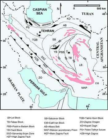
The section under study for the G-LB analysis in Zagros is located in the Ile-Beyk section on Zard Kuh Mountain (270 km west of Shar-e Kurd city) (Fig. 1). The thickness of the Dalan Formation in High Zagros varies from 932 m in the Il-e Beyk section in Zard Kuh Mountain to 332 m in Kuh-e Dena. This section was first studied by Setudehnia (Reference Setudehnia1975), who assigned the Dalan Formation to the Middle to Late Permian according to its fossil content (smaller foraminifers, few fusulinids and corals) in the Lower Dalan Member. In this section, due to the missing Lower Permian Faraghan Formation, the Dalan Formation unconformably overlies the Ordovician shales of the Zard Kuh Formation and conformably underlies Lower Triassic dolomites of the Kangan Formation.
Generalized tectonic regions of Iran showing the location of studied sections for G-L interval in Zagros, Alborz and Central Iran (adopted from Alavi, Reference Alavi1991; Angiolini et al. Reference Angiolini, Gaetani, Muttoni, Stephenson and Zanchi2007). 1 = Il-e Beyk section, Zagros; 2 = type section of the Jamal Formation, Central Iran; 3 = type section of the Ruteh Formation, Alborz.

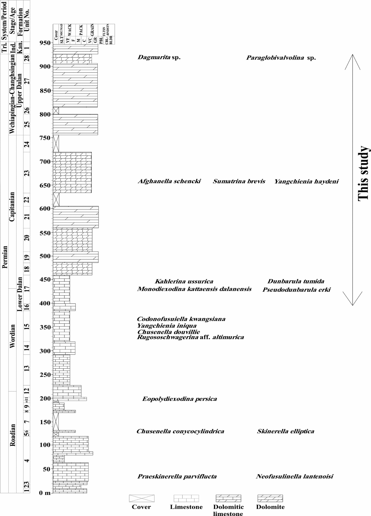
The most detailed fusulinid-based biostratigraphic biozonation and microfacies study of the Dalan Formation in the Il-e Beyk section was carried out by Davydov & Arefifard (Reference Davydov and Arefifard2013). The lower part of the Dalan Formation (484.5 m thick, including units 1–18, Fig. 2) mainly consists of medium- to thick-bedded, partly cliff-forming wackestone, packstone and grainstones with few horizons of mudstone (Davydov & Arefifard, Reference Davydov and Arefifard2013). Four fusulinid biozones are identified in the Lower Dalan Member which are, in ascending order, Praeskinnerella parviflucta – Chusenella? pseudocompacta, Eopolydiexodina persica, Chusenella schwagerinaeformis – Rugososchwagerina zagroensis and Monodiexodina kattaensis. The age of the Lower Dalan Member, based on these fusulinid biozones, is referred to the Roadian to early Capitanian. Cream-coloured thickly bedded dolomite and dolomitic limestones with occasional chert nodules form the main lithological components of the upper part of the Dalan Formation (442.5 m thick, including units 19–28, Fig. 2). The only fusulinid biozone recognized in the Upper Dalan Member is Afghanella schencki – Sumatrina brevis. Rare small foraminifers are found, including Paraglobivalvulina sp. and Dagmarita sp. in the uppermost part of the Upper Dalan Member. Therefore, the late Capitanian to Lopingian age is considered for this part of the Dalan Formation. The G-LB in the Il-e Beyk section was set above the Afghanella schencki – Sumatrina brevis biozone (Davydov & Arefifard, Reference Davydov and Arefifard2013). The G-LB is discussed below, in Section 3.a.2.
Stratigraphic log with distribution of fusulinid and small foraminifers of the Middle to Late Permian Dalan Formation in the Il-e Beyk section, High Zagros (Davydov & Arefifard, Reference Davydov and Arefifard2013). Tri. = Triassic; Ind. = Induan; Kan. = Kangan.

3.a.1. Lithostratigraphy of the G-L interval in the Il-e Beyk section
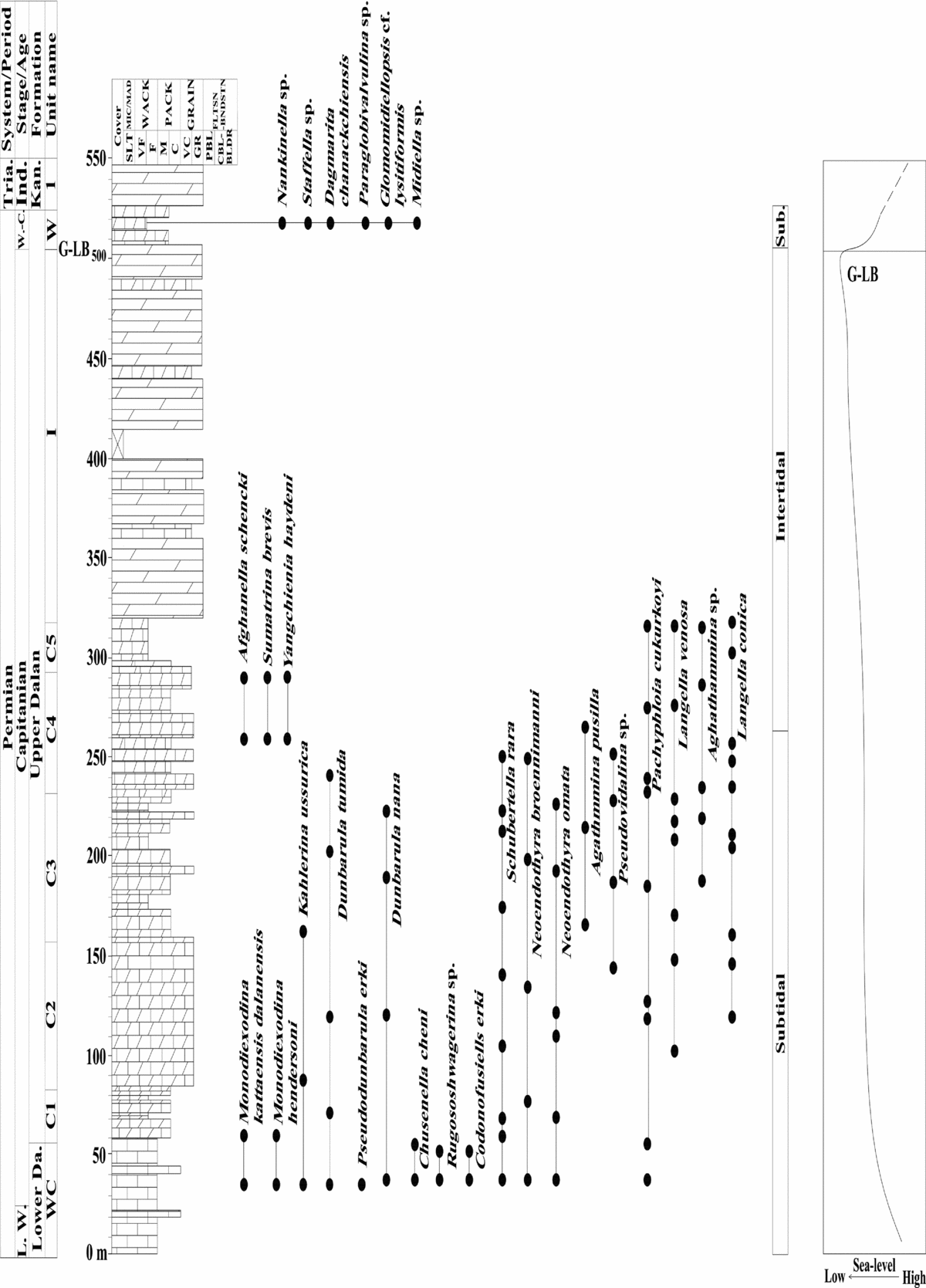
The G-L interval in the Il-Beyk section is composed of the upper part of the Lower Dalan Member and the Upper Dalan Member. The limestones in this interval are bedded and consist mainly of wackestone and packstone. The upper part of the Lower Dalan Member shows light- to dark-grey colours, but the Upper Dalan Member dolostones and dolomitic limestones are light brown to creamy. The stratigraphic column of the Il-e Beyk section showing the G-LB interval is presented in Figure 3. This interval consists of four units: (1) unit WC composed of grey limestone (upper part of the Lower Dalan Member; 60 m thick); (2) unit C composed of light-brown dolomitic limestone (lower part of the Upper Dalan Member; 260 m thick); (3) unit ‘I’ composed of creamy dolomite (middle and upper parts of the Upper Dalan member; 187.5 m thick); and (4) unit W which includes light-brown to creamy dolomitic limestone (uppermost part of the Upper Dalan Member; 20 m thick).
Stratigraphic column of the upper part of the Lower and Upper Dalan members in the Il-e Beyk section, High Zagros. The G-LB occurs at the base of the Late Permian unit W. The large-test fusulinids disappeared at the units C4/C5 boundary before the G-LB. The facies changed from subtidal to intertidal in the late Capitanian and then returned to subtidal in the Wuchiapingian. The shallowing of the late Capitanian depositional environment of the Dalan Formation culminated close to the G-LB. Units WC, C and W deposited in a subtidal setting, while unit I was in the shallower intertidal setting. W.-C. = Wuchiapingian-Changhsingian; Late W. = Late Wordian; Tria. = Triassic; Ind. = Induan; Kan. = Kangan; Lower Da. = Lower Dalan; L. W. = Late Wordian; Sub. = Subtidal.

3.a.1.a. Unit WC: grey limestone
This unit represents the uppermost part of the Lower Dalan Member and is mostly composed of light- to dark-grey limestone. It is 60 m thick (Fig. 3). Wackestone to packstone are the dominant microfacies in this subunit, with rare grainstone. Within this unit, there are fusulinids (Dunbarula tumida, Pseudodunbarula erki, Kahlerina ussurica, Monodiexodina kattaensis), smaller foraminifers, brachiopods, ostracodes and calcareous algae.
3.a.1.b. Unit C: light-brown dolomitic limestone
This unit is composed of light-grey to light-brown dolomitic limestone, and represents the lower part of the Upper Dalan Member. Packstone to grainstone are common, with rare wackestone. Its thickness is 260 m. This unit is subdivided into five subunits, C1–C5.
Subunit C1 (25 m thick) consists of thickly bedded light- grey dolomitic limestone which yields smaller foraminifers, brachiopods, crinoids, ostrocodes and calcarous algae. Packestone is common, intercalated with rare wackestone. Fusulinids are less abundant, with only few occurrences in this subunit.
Subunit C2 (75 m thick) is mainly composed of grey to light-brown medium-bedded dolomitic limestone. Grainstone is common. Oolite moulds are found in two horizons. Smaller foraminifers occur in association with fusulinids, crinoid, brachiopods, ostracodes and calcareous algae.
Subunit C3 (75 m thick) mainly consists of light-grey thickly bedded dolomitic limestone. Wackestone and packstone are common, with rare grainstone. This subunit yields small foraminifers, fusulinids, crinoid, brachiopods, calcarous algae and ostracodes.
Subunit C4 (60 m thick) is mainly composed of medium-bedded light-grey to light-brown dolomitic limestone. Packstone and grainstone are common. Large fusulinids (Afghanella schencki, Sumatrina brevis, Yangchienia haydeni) occur in two horizons. Bioclasts of smaller foraminifers, brachiopods, ostracodes, crinoids and calcareous algae are also present.
Subunit C5 (25 m thick) mainly consists of light-grey thick-bedded dolomitic limestone. Wackestone is common, with rare packstone. Bioclasts of crinoid, brachiopods, ostracodes, small foraminifers and calcareous algae are present with no fusulinid.
3.a.1.c. Unit I: creamy dolomite
This unit consists of medium to thick creamy to light-brown bedded dolomite in which original sedimentary components and fossil contents cannot be identified. The thickness of this unit is 187.5 m. Rare dolomitic limestone is observed in this unit, which is composed of grainstone. Bioclasts of rare brachiopods, crinoids and ostracodes occur in this grainstone.
3.a.1.d. Unit W: light-grey dolomitic limestone
This 20 m thick unit consists of medium-bedded creamy to light-grey dolomitic limestone. Wackestone and packstone are common and bioclasts of small foraminifers, brachiopods, calcareous algae, crinoid and fusulinids are included.
3.a.2. Biostratigraphy and G-L boundary placement in the Il-e Beyk section
The fusulinid-based biostratigraphy of the Dalan Formation in the Il-e Beyk section has five fusulinid biozones: in ascending order, Praeskinnerella parviflucta – Chusenella? pseudocompacta (Roadian in age), Eopolydiexodina persica (late Roadian – early Wordian in age), Chusenella schwagerinaeformis – Rugososchwagerina zagroensis (late Wordian in age), Monodiexodina kattaensis (early Capitanian in age) and Afghanella schencki (late Capitanian in age) (Davydov & Arefifard, Reference Davydov and Arefifard2013). The Lopingian deposits in the upper part of the Upper Dalan Member lack fusulinids and are dated based on its small foraminifers, including Paraglobivalvulina sp. and Dagmarita sp. As mentioned above, Davydov & Arefifard (Reference Davydov and Arefifard2013) have placed the G-LB in the Il-e Beyk section above the Afghanella schencki-bearing deposits. The revision of this section shows that since the first appearance of the Lopingian, small foraminifers (Paraglobivalvulina sp., Dagmaritia chanackchienais, Glomomidiellopsis cf. lysitiformis and Midiella sp.) are recorded 250 m above the Capitanian Afghanella schencki – Sumatrina brevis biozone, and there is a barren interval zone from the last appearance datum (LAD) of the large fusulinids in this section to the first appearance datum (FAD) horizon of the Late Permian small foraminifers; therefore, the G-LB can logically be located immediately at the FAD horizon of Late Permian small foraminifers, i.e. at the base of unit W.
In the 527.5 m thick G-L interval in the Il-e Beyk section, fusulinids are found abundantly only in one horizon in unit WC and another in subunit C4. They are very rare in units C1, C2 and C3 and not found in units I and W (Fig. 3). In unit WC, both large- and small-test fusulinids occur including Dunbarula tumida, Dunbarula nana, Pseudodunbarula erki, Kahlerina ussurica, Monodiexodina kattaensis, M. hendesoni, Codonofusiella erki, Rugososchwagerina sp. and Schubertella rara. Subunits C1–C3 have occurrences of rare small-test fusulinids (e.g. Dunbarula nana, D. tumida, Kahlerina ussurica and Schubertella rara) with no large-test fusulinids. In subunit C4 large-test fusulinids reappear, such as Afghanella schencki, Sumatrina brevis and Yangchienia haydeni. In contrast, no fusulinids are found from the overlying 247.5 m thick interval, i.e. 60 m thickness of the remaining part of subunit C4 (light-brown dolomitic limestone) and the 187.5 m thick unit I (creamy dolomite). Long-ranging fusulinids such as Nankinella sp. and Staffella sp. occur without large-test ones in unit W. Small foraminifers associated with these fusulinids of units WC and C1–C5 contain Neoendothyra broennimanni, N. omata, Agathammina pusilla, Pachyphloia iranica, Langella conica, L. venosa and Pseudovidalina sp. Based on these fusulinid contents of the Dalan Formation in the G-L interval, it can be subdivided into three zones including a zone distinguished by large-test fusulinids (Afghanella, Sumatrina, Yangchienia accompanied by small-test fusulinids), a barren interval, a zone with long-ranging small fusulinids along with small foraminifers indicative of the Late Permian (Fig. 3).
According to Davydov & Arefifard (Reference Davydov and Arefifard2013), unit WC is latest Wordian – early Capitanian in age, and unit C is correlated with the late Capitanian. Unit I has no fusulinid or small foraminifers for age determination, but since the first appearance of the small-test fusulinids and Late Permian small foraminifers is immediately above unit I, it appears that unit I is also of Capitanian age. Unit W is assigned to the Late Permian, most likely Wuchiapingian. Consequently the G-LB is set at the base of unit W. Moreover, no large-test fusulinids are found in subunit C5 of the Capitanian dolomitic limestone, therefore the base of subunit C5 (c. 247.5 m below the G-LB) is identified as the extinction level of the large-test fusulinids in the Il-e Beyk section.
3.b. Central Iran
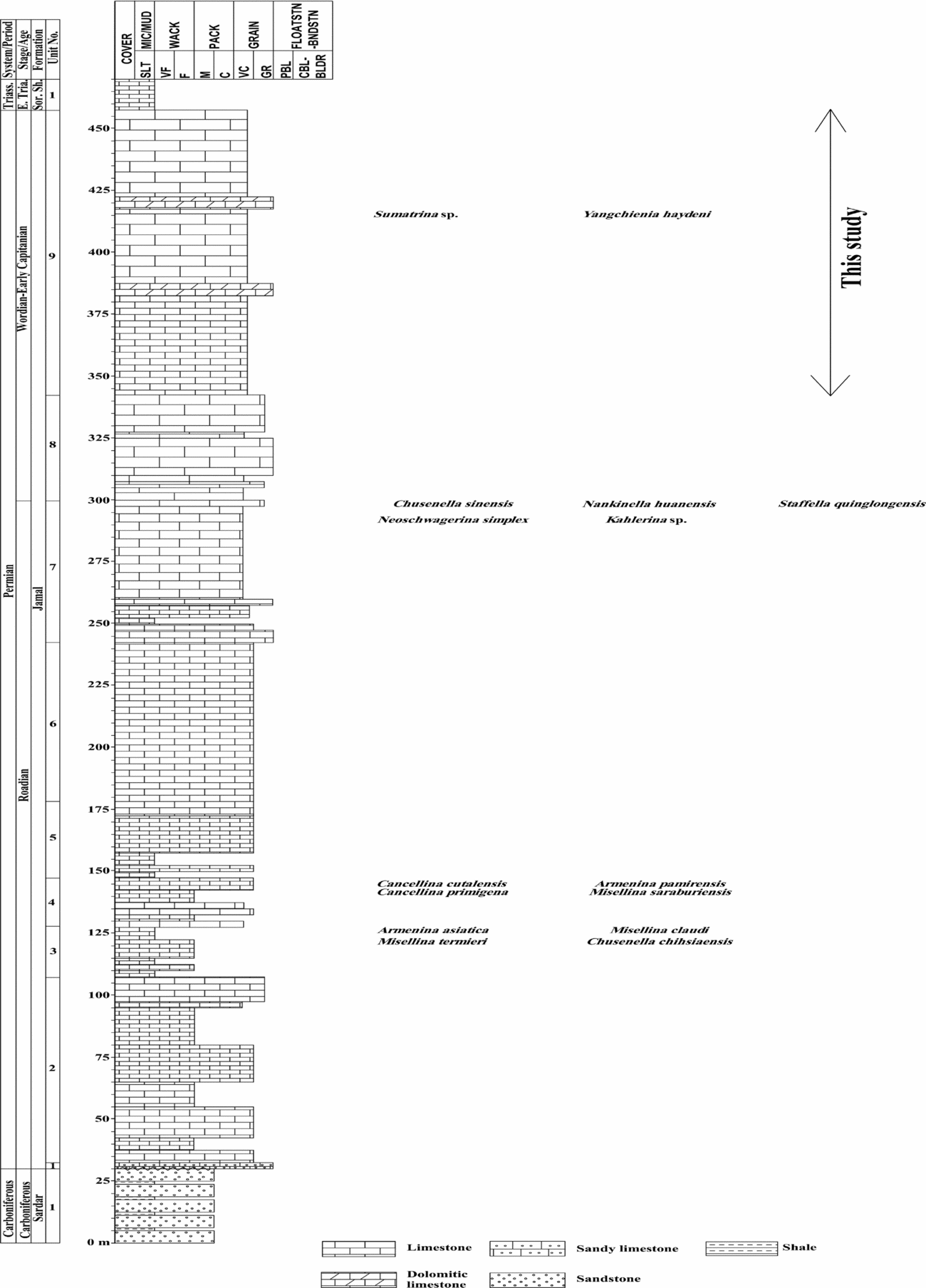
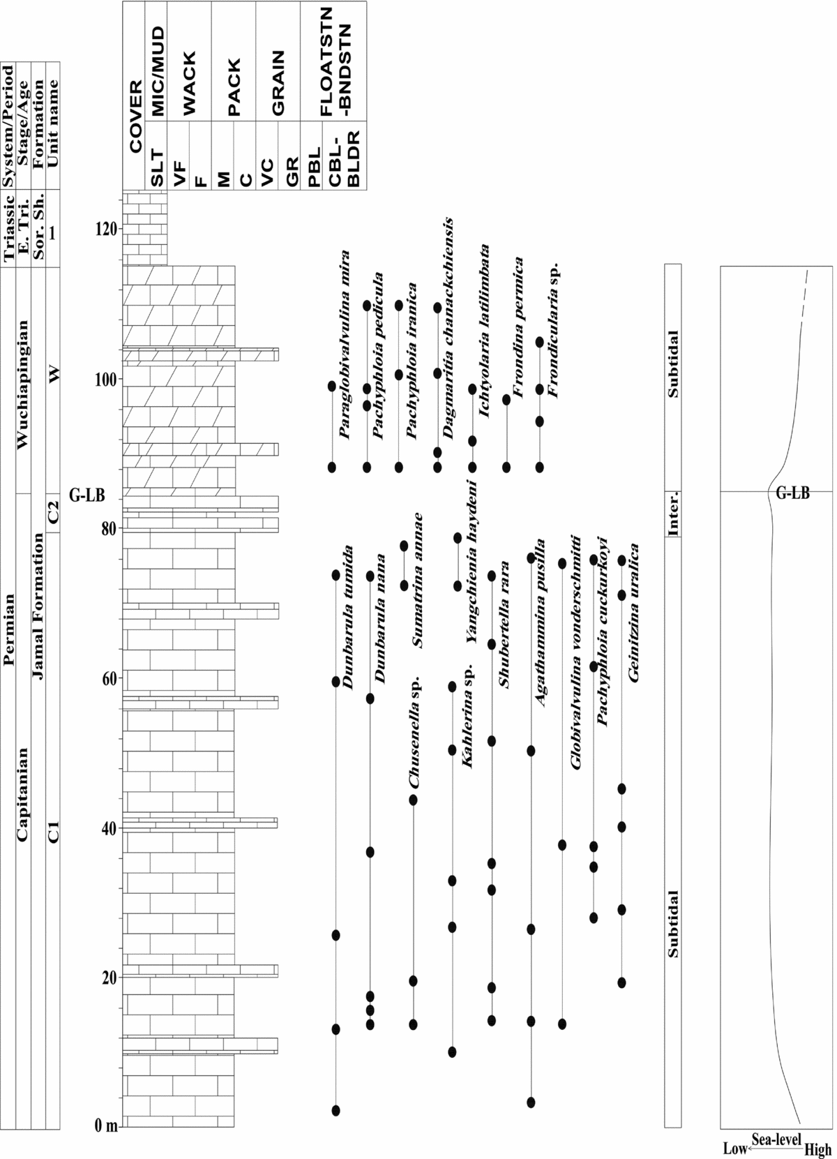
The Middle to Late Permian Jamal Formation is widespread in Central Iran. The outcrops of this formation are biostratigraphically well studied in the type section of this formation in Kuh-e Shotori, c. 52 km SE of Tabas town (Stöcklin, Eftekhar-Nezhad & Hushmand-Zadeh, Reference Stöcklin, Eftekhar-Nezhad and Hushmand-Zadeh1965; Ruttner, Nabavi & Hajian, Reference Ruttner, Nabavi and Hajian1968; Kahler & Kahler, Reference Kahler and Kahler1979; Jenny-Deshusses, Reference Jenny-Deshusses1983; Arefifard, unpub. Ph.D. thesis, Shahid Beheshti Univ., 2006) (Fig. 1). Limestone, dolomitic limestone and dolomite are the dominant lithologies in the Jamal Formation. Detailed biostratigraphy, microfacies analysis and study of the depositional environment of the Jamal Formation in its type section were carried out by Arefifard & Davydov (Reference Arefifard and Davydov2004), Arefifard (unpub. Ph.D. thesis, Shahid Beheshti Univ., 2006) and Arefifard & Isaacson (Reference Arefifard and Isaacson2011). The Jamal Formation in its type section unconformably overlies the Carboniferous sandstones of the Sardar Formation, with a significant hiatus between these two formations. The Lower Triassic yellow platy micritic limestone of the Sorkh Shale Formation conformably overlies the Jamal Formation. The Jamal Formation in its type section, 427.5 m thick, is mainly composed of grey to dark-grey medium- to thick-bedded bioclastic limestone with fossil content such as brachiopods, crinoid, bryozoan, ostracodes, gastropods, corals, small foraminifers, fusulinids and calcareous algae. The interbeds of grey medium-bedded oolitic limestone are found with the bioclastic limestone. The upper portion of the Jamal Formation in its type section is partly dolomitized and contains light-brown to grey medium-bedded dolomitic limestone. The lower part of the Jamal Formation (units 1–7; 245 m thick) in this section consists of medium-bedded grey to dark grey limestone containing fusulinids of Armenina asiatica, Cancelina cutalensis, and Misellina saraburiensis (Arefifard, unpub. Ph.D. thesis, Shahid Beheshti Univ., 2006). The upper part of the Jamal Formation (units 8–9; 180 m thick) is composed mainly of medium- to thick-bedded light-grey limestone and contains Neoschwagerina simplex and Nankinella huanensis, Chusenella sinensis, Nankinella huanensis, Staffella quinglongensis, Kahlerina sp., Yangchienia haydeni and Sumatrina sp. The limestones of the upper part of the Jamal Formation are replaced by dolomitic limestone with no diagnostic Late Permian fossils (Arefifard, unpub. Ph.D. thesis, Shahid Beheshti Univ., 2006) (Fig. 4). On the basis of fusulinids and small foraminider, the aforementioned different parts of the Jamal Formation in its type section are assigned to the Roadian (lower part) and Wordian to early Capitanian (upper part) (Arefifard, unpub. Ph.D. thesis, Shahid Beheshti Univ., 2006). The G-LB is not identified in this section by Arefifard (unpub. Ph.D. thesis, Shahid Beheshti Univ., 2006).
Stratigraphic log with distribution of fusulinid and small foraminifers of the Middle to Late Permian Jamal Formation in its type section, Shotori Mountains, Central Iran (Arefifard, unpub. Ph.D. thesis, Shahid Beheshti Univ., 2006). E. Tria. = Early Triassic; Sor. Sh. = Sorkh Shale; Triass. = Triassic.

3.b.1. Lithostratigraphy of the G-L interval in the type section of the Jamal Formation
Based on the new collections of litho- and biostratigraphic data of the Jamal Formation in its type section, the Jamal Formation can be subdivided into three parts, lower, middle and upper. The G-L interval in this section consists of the upper portion of the middle part and the upper part of the Jamal Formation (Fig. 5). The upper portion of the middle part of the Jamal Formation shows grey to light-grey colours but the dolomitic limestones of the upper part of the Jamal Formation are light-brown to cream-coloured. The stratigraphic log of the Jamal Formation showing the G-L interval in its type section is illustrated in Figure 5. This interval includes two units: unit C composed of grey limestone (upper portion of the middle part of the Jamal Formation; 85 m thick), and unit W composed of creamy dolomitic limestone (upper part of the Jamal Formation; 30 m thick).
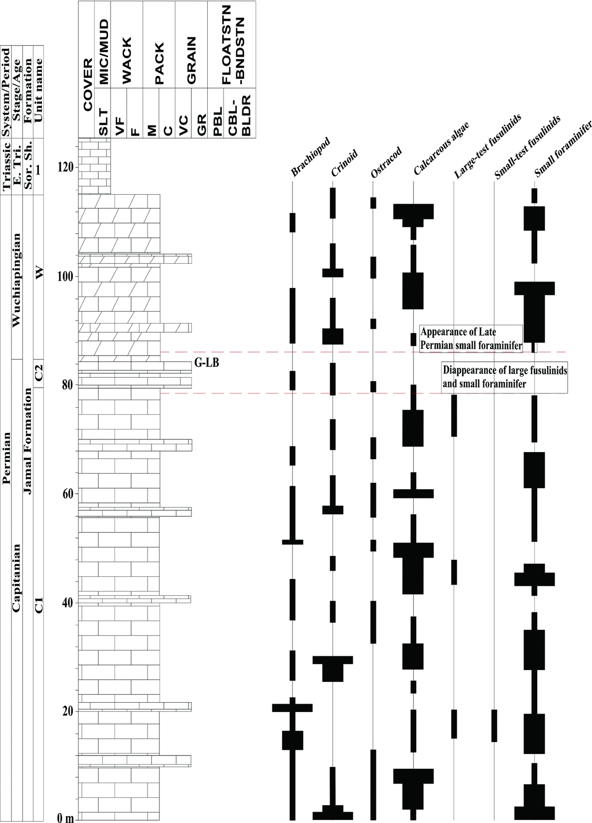
Stratigraphic log of the upper part of the Jamal Formation in its type section, Shotori Mountains, Central Iran. The G-LB occurs at the base of the Late Permian unit W. The large-test fusulinids disappeared at the units C1/C2 boundary before the G-LB. The facies changed from subtidal to intertidal in the late Capitanian and then returned to subtidal in the Wuchiapingian. Note the shallowing during the late Capitanian and deepening in the Wuchiapingian which correspond to sea-level global change at the G-LB (Haq & Schutter, Reference Haq and Schutter2008). The G-LB marks the lowest sea level. Subunit C1 and unit W deposited in a subtidal setting, whereas subunit C2 was in a shallower intertidal setting. E. Tri. = Early Triassic; Inter. = intertidal; Sor. Sh. = Sorkh Shale.

3.b.1.a. Unit C: grey limestone
This unit is composed of grey to light-grey limestone and its total thickness is 85 m. It is subdivided into two subunits, C1 and C2. Packstone to grainstone are the main microfacies in these two subunits, with rare interbeds of wackestone.
Subunit C1 (79 m thick) mainly consists of medium- to thick-bedded grey to light-grey limestone. Packstones are dominant, with rare interbeds of grainstone. Small foraminifers and calcareous algae occur abundantly in association with fusulinids, brachiopods, crinoids and ostracodes. Within this subunit, well-sorted ooids occur in grainstones.
Subunit C2 (6 m thick) mainly consists of thick-bedded grey limestone. Grainstones are common, with interbeds of packstone. This subunit yields bioclasts of brachiopods, crinoids, ostracodes and rare small foraminifers.
3.b.1.b. Unit W: creamy dolomitic limestone
This unit is composed of thick-bedded light-grey to creamy dolomitic limestone. It is 30 m thick. Packstone is common, with rare interbedded grainstone. Bioclasts of small foraminifers, brachiopods, crinoid, ostracodes and calcareous algae are present.
3.b.2. Biostratigraphy and G-L boundary placement in type section of the Jamal Formation
The distribution and diversity of fusulinids in the Middle to Late Permian assigned sectors of the Jamal Formation in its type section are not abundant, and therefore the dating of these parts of the Jamal Formation in this section is based on both small foraminifers and fusulinids. Arefifard (unpub. Ph.D. thesis, Shahid Beheshti Univ., 2006) has suggested a Wordian to early Capitanian age for the upper part of the Jamal Formation in its type section. The re-evaluation of the small foraminifers and fusulinid assemblages of the upper portion of the middle part of the Jamal Formation and its upper part reveals that in the 30 m thick dolomitic limestones in the upper part of the Jamal Formation there are occurrences of small foraminifers indicative of the Lopingian (Late Permian), probably Wuchiapingian, including Dagmaritia chanackchiensis, Ichtyolaria latilimbata and Frondina permica, Frodicularia sp., Paraglobivalvulina mira, Pachyphloia iranica and P. pedicula. In unit C1 there are a few occurrences of Yangchienia haydeni, and newly identified Sumatrina annae, Dunbarula nana, D. tumida, Kahlerina sp. and Schubertella rara along with small foraminifera such as Agathammina pusilla, Pachyphloia culurkoyi, Geinitzina uralica and Globivalvulina vonderschmittie. The LAD of these fusulinids is 6 m below the top of unit C. No fusulinid is recorded in Lopingian deposits in the type section of the Jamal Formation. The FAD of the aforementioned Late Permian small foraminifers is in the lowermost part of unit W.
According to the small foraminifers and fusulinid content of the Jamal Formation in its type section, it can be biostratigraphically subdivided into three zones, including a zone with large-test fusulinids (Sumatrina and Yangcheinia accompanied by smaller foraminifers), a barren interval zone with no small foraminifers and fusulinids and a zone recognized with small foraminifers indicative of Lopingian (Fig. 5). The small foraminifers and fusulinid occurrences in the Jamal Formation indicate that unit C is Capitanian in age, and unit W is assigned to the Lopingian, probably Wuchiapingian (Fig. 5). Since, there is no occurrence of large-test fusulinids in the barren interval zone and the first appearance of the Late Permian small foraminifers occurs at the base of unit W, it can be concluded that the barren interval zone is likely Capitanian in age. Therefore, the G-LB is located at the base of the dolomitic limestones of unit W at the top of the Jamal Formation. In addition, no large fusulinids occur above the C1/C2 boundary, therefore the base of subunit C2 is considered as the extinction level of all large-test fusulinids in the type section of the Jamal Formation.
3.c. Alborz
The Middle Permian carbonate succession in central and eastern Alborz is known as the Ruteh Formation, and since its introduction by Assereto (Reference Assereto1963) numerous biostratigraphic studies have been carried out on this formation. The brachiopod and foraminifer content of the Ruteh Formation has been studied since the 1960s (e.g. Fantini Sestini, Reference Fantini1965; Stepanov, Golshani and Stöcklin, Reference Stepanov, Golshani and Stöcklin1969; Bozorgnia, Reference Bozorgnia1973; Arefifard, unpub. M.Sc. thesis, Shahid Beheshti Univ., 1997; Gaetani et al. Reference Gaetani, Angiolini, Ueno, Nicora, Stephenson, Sciunnach, Rrttori, Price, Sabouri, Brunet, Wilmsen and Granath2009; Crippa & Angiolini, Reference Crippa and Angiolini2012).
The Ruteh Limestone is composed of medium- to thick-bedded bioclastic limestone in its lower part, followed by medium-bedded light to dark grey bioclastic limestone with chert nodules and marlstone interbeds. The top of the Ruteh Limestone is capped with a lateritic horizon, and the upper boundary of this formation is placed at the base of this lateritic horizon (Arefifard, unpub. M.Sc. thesis, Shahid Beheshti Univ., 1997; Gaetani et al. Reference Gaetani, Angiolini, Ueno, Nicora, Stephenson, Sciunnach, Rrttori, Price, Sabouri, Brunet, Wilmsen and Granath2009). The Ruteh Formation is unconformably underlain by the Early Permian Shah Zeid Formation of the Dorud Group. The upper boundary of the Ruteh Formation is disconformably overlain by the Early to Middle Triassic Elika Formation in most of its outcrops in the southern part of Alborz where the Lopingian Nesen Formation is missing, except for its type section in Ruteh Valley. In the northern part of the Alborz range and also toward the east, the Late Permian Nesen Formation unconformably overlies the Ruteh Limestone. Up to 150 m thick basal lava flows and tuffs which occur within the upper part of the Ruteh Limestone (but not at its top) have been reported in the area north of the Elika-Nesen (Glaus, Reference Glaus1965; Gaetani et al. Reference Gaetani, Angiolini, Ueno, Nicora, Stephenson, Sciunnach, Rrttori, Price, Sabouri, Brunet, Wilmsen and Granath2009). The thickness of the Ruteh Limestone varies between 150 and 250 m and reaches its maximum (600 m) toward the Caspian side of the Alborz.
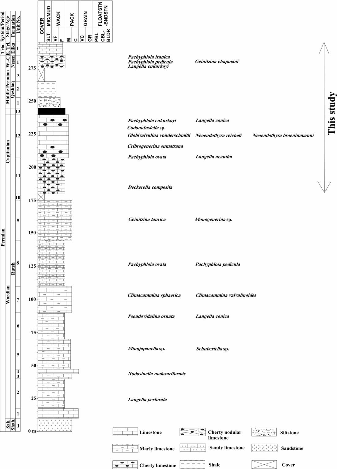
The stratigraphic section chosen for G-LB interval analysis in the Alborz area is the type section of the Ruteh Formation located in the northern part of Ruteh village in Ruteh Valley (Fig. 1). The Ruteh Formation is divisible into two parts. The lower part (170 m thick) is composed of medium- to thick-bedded and partly cliff-forming light-grey to grey marly bioclastic limestone. Bioclasts of brachiopods, crinoids, gastropods, bryozoans, echinoids, bivalves, ostracodes, small foraminifers and rare fusulinids occur in the lower part of the Ruteh Limestone. Fusulinids, Minojapanella and Schubertella sp., are found in this part (Fig. 6). The upper part of the Ruteh Formation (60 m thick) comprises medium-bedded grey bioclastic limestone with black chert nodules. This part yields fusulinids such as Codonofusiella sp. Small foraminifers are common in the Ruteh Limestone, but fusulinids are poor and show very low distribution (Fig. 6). Therefore, dating of the Ruteh Formation based on just fusulinids is not well constrained. According to both small foraminifers and fusulinid contents, a Wordian to Capitanian age is proposed for the Ruteh Limestone in its type section (Arefifard, unpub. M.Sc. thesis, Shahid Beheshti Univ., 1997; Gaetani et al. Reference Gaetani, Angiolini, Ueno, Nicora, Stephenson, Sciunnach, Rrttori, Price, Sabouri, Brunet, Wilmsen and Granath2009). The G-LB is set below the laterite/bauxite horizon at the top of the Ruteh Formation (Arefifard, unpub. M.Sc. thesis, Shahid Beheshti Univ., 1997; Gaetani et al. Reference Gaetani, Angiolini, Ueno, Nicora, Stephenson, Sciunnach, Rrttori, Price, Sabouri, Brunet, Wilmsen and Granath2009).
Stratigraphic log with distribution of fusulinid and small foraminifers of the Middle Permian Ruteh and Late Permian Nesen formations in the type section of the Ruteh Formation, Ruteh Valley, Alborz (Arefifard, unpub. M.Sc. thesis, Shahid Beheshti Univ., 1997; Gaetani et al. Reference Gaetani, Angiolini, Ueno, Nicora, Stephenson, Sciunnach, Rrttori, Price, Sabouri, Brunet, Wilmsen and Granath2009). E. Tria. = Early Triassic; W.-C. = Wchiapingian-Changhsingian; Sak. = Sakmarian; Shah. = Shah Zeid; Tria. = Triassic.

3.c.1. Lithostratigraphy of the G-L interval in the type section of the Ruteh Formation
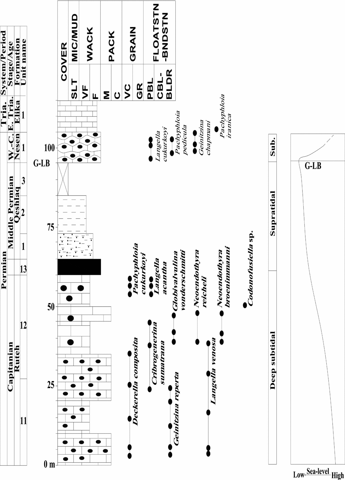
The G-L interval in the type section of the Ruteh Formation in Ruteh Valley consists of the upper part of the Ruteh Formation, Qeshlagh Formation and Nesen Formation. The stratigraphic log of the Ruteh Formation showing the G-L interval is presented in Figure 7. This interval includes three units: (1) unit C composed of grey limestone with black chert nodules (upper part of the Ruteh Limestone; 60 m thick), (2) unit I composed of basal red siltstone and upper brown shale (Qeghlaq Formation, c. 20 m thick) and (3) unit W composed of grey cherty nodular limestone (upper part of the Nesen Formation; c. 10 m thick).
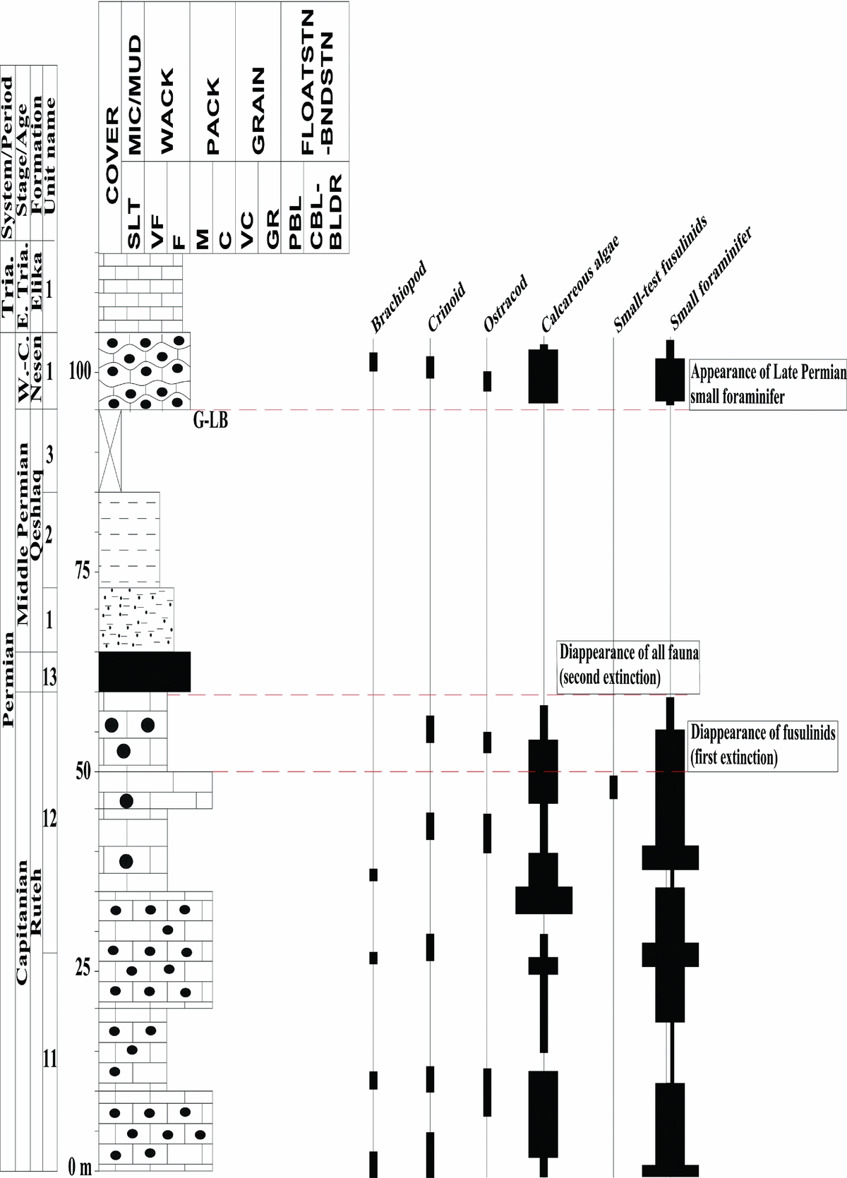
Stratigraphic log of the Ruteh, Qeshlaq and Nesen formations in the type section of the Ruteh Formation, Ruteh Valley, Alborz. The G-LB occurs at the base of the Late Permian Nesen Formation. The fusulinids disappeared 35 m below the base of unit W and before the G-LB. Units C and W were deposited in a subtidal setting, whereas unit ‘I’ was in a supratidal setting. The subaerial exposure, which is remarkable for the laterite/bauxite horizon and the continental deposits of the Qeshlaq Formation close to the G-LB, marks lowest sea level in the late Capitanian. E. Tria. = Early Triassic; W.-C. = Wchiapingian-Changhsingian; Sub. = Subtidal; Tria. = Triassic.

3.c.1.a. Unit C: grey limestone
This unit represents the upper part of the Ruteh Formation and is 60 m thick. It is subdivided into two subunits, C1 and C2. Each subunit is composed of grey bioclastic limestone. Wackestone and packstone are the dominant microfacies.
Subunit C1 (50 m thick) is composed mainly of medium- to thick-bedded grey to dark-grey limestone with black small chert nodules. Wackestone and packstone are the dominant microfacies. Fusulinids are poorly presented and only Codonofusiella sp. is recorded (Arefifard, unpub. M.Sc. thesis, Shahid Beheshti Univ., 1997; Gaetani et al. Reference Gaetani, Angiolini, Ueno, Nicora, Stephenson, Sciunnach, Rrttori, Price, Sabouri, Brunet, Wilmsen and Granath2009). Other bioclasts include small foraminifers, brachiopods, crinoid, bivalve, gastropod, calcareous algae and ostracodes.
Subunit C2 (10 m thick) mainly consists of thick-bedded grey limestone with relatively large chert nodules. It consists mostly of wackestone with small foraminifers, calcareous algae, bivalve, ostracodes, crinoids and brachiopods.
3.c.1.b. Unit I: red siltstone and brown shale
This unit mostly consists of red siltstone in its lower part, with red conglomerate found in thin horizons in its basal and upper part. These siltstones are followed by brown shales in the upper part of this unit. This unit is 20 m thick and represents the silisiclastics of the Qeshlaq Formation.
3.c.1.c. Unit CH: grey cherty nodular limestone
This unit is mostly composed of medium-bedded grey chert nodular limestone representative of the upper part of the Late Permian Nesen Formation. It is 10 m thick. Wackestone to packstone are common. Bioclasts of small foraminifers, brachiopods, crinoids and ostracodes with no fusulinids are found in this unit.
3.c.2. Biostratigraphy and G-L boundary placement in the type section of the Ruteh Formation
Like the Jamal Formation in Central Iran, the Ruteh Limestone has very low abundances of fusulinids and, as mentioned before, only one fusulinid taxon (Codonofusiella sp.) is reported from the upper part of the Ruteh Limestone, which is a part of the G-L interval. The fusulinid occurrences in the lower part of this formation are low as well, and never comprise a recognizable assemblage. Therefore, the age of the Ruteh Formation is determined both by small foraminifers and rare fusulinids. The small foraminifer taxa in the upper part of this formation are Deckerella composita, Pachyphloia iranica, Neoendothyra reicheli, N. broennimanni, Globivalvulina vonderschmitti and Cribrogenerina sumatrana, Geinitzina reperta, Langella venosa. These small foraminifers are accompanied by Codofusiella sp. A Capitanian age is apparent for the upper part of the Ruteh Formation (unit C).
No age-diagnostic fossils are found in the siliciclastics of the Qeshlaq Formation (unit I). Gaetani et al. (Reference Gaetani, Angiolini, Ueno, Nicora, Stephenson, Sciunnach, Rrttori, Price, Sabouri, Brunet, Wilmsen and Granath2009) recovered poorly preserved palynomorphs, wood fragments and sheet cellular materials from the Qeshlaq Formation in the Ruteh section, but the precise age for the Qeshlaq Formation cannot be obtained by these plant fossils. In the Jauzchal section, in eastern Alborz, rich palynomorphs of the Qeshlaq Formation suggest a Middle Permian age (Gaetani et al. Reference Gaetani, Angiolini, Ueno, Nicora, Stephenson, Sciunnach, Rrttori, Price, Sabouri, Brunet, Wilmsen and Granath2009). The first record of the Late Permian small foraminifers is in the overlying Nesen Formation, and there is no evidence of well-constrained Late Permian fossils in the Qeshlaq Formation. Therefore, it is more logical to consider the siliciclastics of Qeshlaq Formation to be Middle Permian in age. The area between the top of the Qeshlaq Formation and the base of the Upper Nesen Member is covered and there is no a complete outcrop of the Nesen Formation in the Ruteh section. The Wuchiapingian Lower Nesen Member, which is composed of dark-grey shales interbedded with thin- to medium-bedded marly limestone, is absent in the type section of the Ruteh Limestone. Small foraminifers such as Langella cukurkoyi, Geinitzina chapmani, Pachyphloia ovata, P. pedicula and P. iranica occur in unit CH. The lithological features of unit C are indicative of the cherty limestones of the Changhsingian Upper Nesen Member (Arefifard, unpub. M.Sc. thesis, Shahid Beheshti Univ., 1997; Gaetani et al. Reference Gaetani, Angiolini, Ueno, Nicora, Stephenson, Sciunnach, Rrttori, Price, Sabouri, Brunet, Wilmsen and Granath2009). In other sections of the Nesen Formation in northern and eastern Alborz, two Changhsingian brachiopod assemblages including Permophricodothyris ovate and Enteletes lateroplicatus are identified in the Upper Nesen Member (Angiolini & Carabelli, Reference Angiolini and Carabelli2010). In the type section of the Nesen Formation, in the Elika section, the Upper Nesen Member contains small foraminifers of Dagmarita chanakchiensis, Paradagmarita spp., Paraglobivalvulina spp., Reichelina sp. and Hemigordius sp. correlative with the Changhsingian Paradagmarita zone (Gaetani et al. Reference Gaetani, Angiolini, Ueno, Nicora, Stephenson, Sciunnach, Rrttori, Price, Sabouri, Brunet, Wilmsen and Granath2009). Based on these data, the G-L interval in the Ruteh section can be biostratigraphically divided into three zones including a zone characterized by small foraminifers and very rare fusulinids, a barren interval zone and a zone with small foraminifers with no fusulinids (Fig. 7). The G-LB is set at the base of the Upper Nesen Member, where the first Late Permian fossils are recovered. Moreover, the last occurrence of the fusulinids as Codonofusiella sp. is recorded 35 m below the G-LB. Therefore, the base of subunit C2 is considered as the extinction level of fusulinids in the type section of the Ruteh Formation.
4. Fossil abundance change around the G-L boundary in Zagros, Central Iran and Alborz
In all the studied G-L intervals, faunal diversity is generally very high in grey to dark-grey limestones of the G-L interval, including units WC (grey limestone) and C (light-brown dolomitic limestone) of the Dalan Formation in the Il-e Beyk section, Zagros; unit C (grey limestone) of the Jamal Formation, in its type section, Central Iran; and unit C (grey limestone) of the Ruteh Formation in its type section, Alborz. Conversely, the overlying transitional interval and the Late Permian deposits yield low-diversity faunal composition in units I (creamy dolomite) and W (light-grey dolomitic limestone) of the Dalan Formation in the Il-e Beyk section, Zagros; units C2 (grey limestone) and W (creamy dolomitic limestone) of the Jamal Formation in its type section, Central Iran; and units I (red siltstone and brown shale of the Qeshlaq Formation) and HC (grey cherty nodular limestone of the Nesen Formation) in the type section of the Ruteh Formation, Alborz. The large-test fusulinids, representative of shallow water biota, undergo drastic changes before the G-LB (Figs 8, 9, 10). This trend is confirmed in all selected sections across the G-LB for this study. The abundance of shallow marine fauna, including fusulinids, small foraminifers, brachiopods, crinoids, bryozoans, calcareous algae, corals and ostracodes, for all studied G-L intervals in this contribution is shown in Figures 8–10.
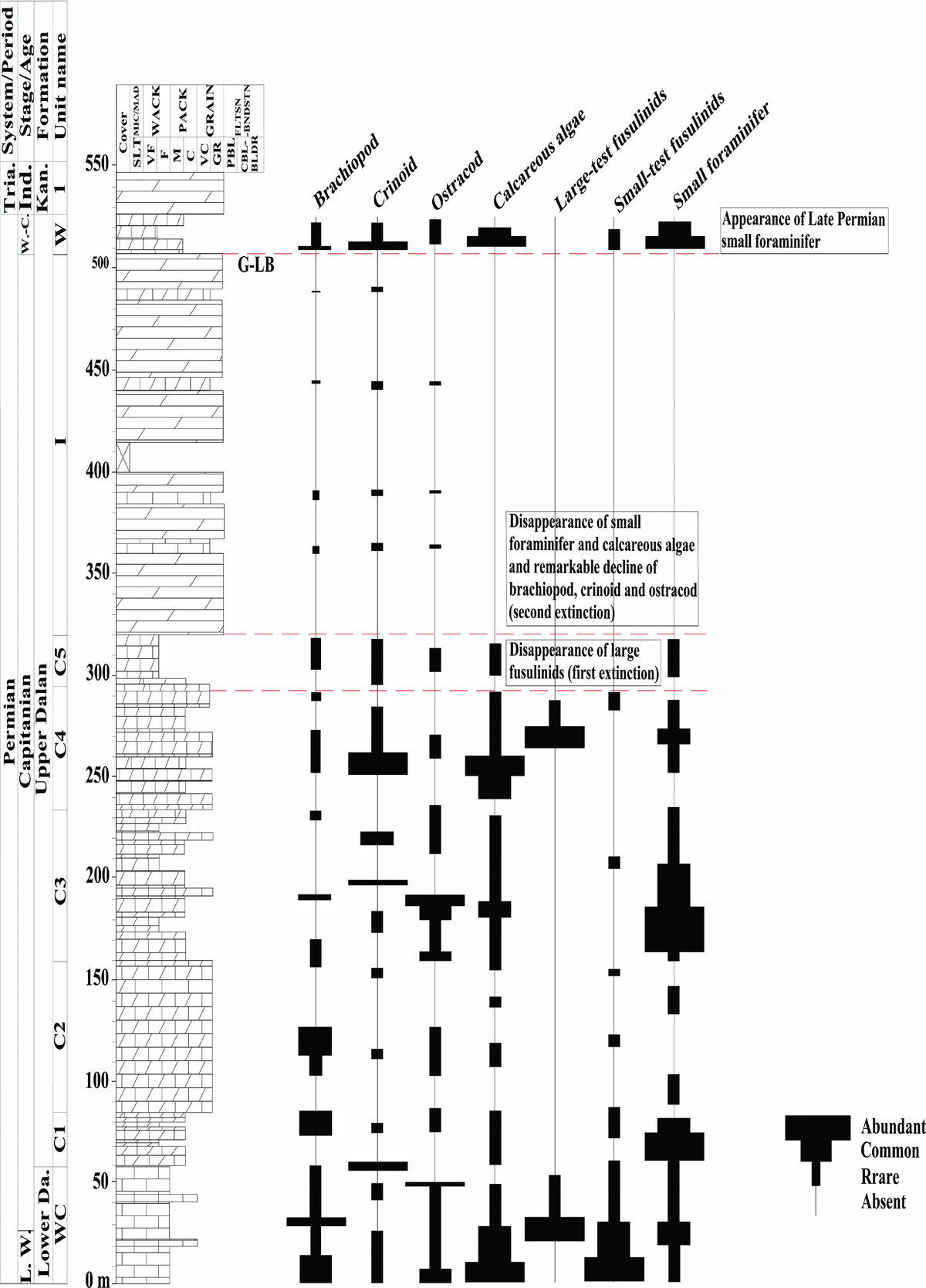
Biostratigraphic distributions of shallow marine bioclasts in the interval around the G-LB in the Il-e Beyk section. The shallow marine faunas disappeared in two steps: first at the base of subunit C5 and second within unit I. The first episode includes the total disappearance of the large fusulinids, and the second involves the decline of the brachiopods, crinoids and ostracodes and disappearance of the small foraminifers and calcareous algae. Unit W shows the time of shallow marine biota recovery. Ind. = Induan; Kan. = Kangan; L. W. = Late Wordian; Lower Da. = Lower Dalan; W.-C. = Wchiapingian-Changhsingian; Tria. = Triassic.

Biostratigraphic distributions of shallow marine bioclasts in the interval around the G-LB in the type section of the Jamal Formation. The shallow marine faunas disappeared in one step which is set at the base of subunit C2. The episode includes the disappearance of the large fusulinids. Unit W shows the time for recovery. E. Tri. = Early Triassic; Sor. Sh. = Sorkh Shale.

Biostratigraphic distributions of shallow marine bioclasts in the G-LB interval in the Ruteh Formation type section. The shallow marine faunas disappeared in two steps: first at the base of subunit C2 and second within unit I. The first episode includes the disappearance of the large fusulinids, and the second involves the total loss of biota within unit I. Unit W shows the appearance of the Late Permian small foraminifers. E. Tria. = Early Triassic; W.-C. = Wchiapingian-Changhsingian; Tria. = Triassic.

In the Il-e Beyk section, small foraminifers, brachiopods, crinoids, ostracodes and fusulinids are relatively abundant in unit WC. Conversely, above the subunit C4/C5 boundary, fusulinids are absent. The last occurrence of large-test fusulinids is in the upper part of subunit C4 and they do not occur in the overlying strata. This indicates that a significant biotic change took place during the deposition of subunit C4, especially at the subunits C4/C5 boundary. Furthermore, in unit I, brachiopods, crinoids and ostracodes declined considerably. Small foraminifers and fusulinids are absent in unit I. This suggests another change in faunal composition. According to these data, the end-Guadalupian major extinction in the Il-e Beyk section appears in two-stepped changes of faunal composition. The first step is the disappearance of the fusulinids at the C4/C5 boundary and the second incident is the drastic decline of brachiopods, crinoids and ostracodes and the disappearance of small foraminifers and calcareous algae in unit I (Fig. 8). Therefore, the barren interval is divisible into two subintervals; the lower half of the barren interval extends from the base of subunit C5 to base unit I (c. 25 m thick), and the upper half of the interval extends from the base of unit I to the base of unit W (c. 187.5 m thick). The first appearance of the Late Permian small foraminifers is recorded in unit W which marks the G-LB. This horizon is 214.5 m above the C4/C5 boundary and 2 m above the second biodiversity change and reveals that there is a demise of many taxa, as well as a drop in biodiversity which occurred before the Capitanian (Fig. 8)
In the type section of the Jamal Formation, small foraminifers, brachiopods, crinoids, ostracodes, calcareous algae and fusulinids are common, particularly in subunit C1. In contrast, above the C1/C2 boundary, fusulinids and small foraminifers disappear (Fig. 9). This indicates an important change in faunal composition somewhere around the C1/C2 boundary. The biotic change at the end of the Capitanian in the type section of the Jamal Formation occurs in only one step which includes the disappearance of fusulinids and small foraminifers at the C1/C2 boundary. The barren interval zone extends from the C1/C2 boundary to the basal part of unit W. The Late Permian small foraminifers horizon is 9 m above the C1/C2 boundary and indicates that the biodiversity drop took place before the Capitanian.
In the Ruteh section, small foraminifers, brachiopods, crinoids, ostracodes, calcareous algae and rare fusulinids are present in unit C1. However, above the subunit C1/C2 boundary, fusulinids are absent, implying an important biotic event which occurred after the deposition of unit C1 (Fig. 10). No shallow marine biota occur in unit I, indicating another change in biotic composition. These data reveal that, as with the Il-e Beyk section, the end-Capitanian biotic losses came about in two steps. The first step is the disappearance of the fusulinids at the C1/C2 boundary and the second step is the disappearance of all shallow marine fauna in unit I. Therefore, the barren interval is divisible into two subintervals: the lower half of the barren interval extends from the base of subunit C2 to the base unit I (c. 10 m thick), and the upper half includes the base of unit I to the base of unit W (c. 25 m thick). The first appearance of the Late Permian small foraminifers is recorded in unit W which is designated as the G-LB. This horizon is 40 m above the C1/C2 boundary and 1 m above the second faunal composition change. It indicates that biodiversity drop happened before the Capitanian.
5. Environmental change around the G-L boundary
The presence of the large-test fusulinids and calcareous algae including Mizzia and Permocalculus throughout units WC and C of the Dalan Formation, in the Il-e Beyk section, Zagros, implies that deposition of these two units was in a shallow water setting. The bioclastic wackestone to packstone and the presence of lime mud suggest a quiet environment. Even though there is interbedding of the bioclastic grainstone among these bioclastic wackestone and packstones indicating a high-energy setting, the dominance of the bioclastic wackestone and packstones in units WC and C implies the deposition of these units in subtidal zone. The open lagoon behind the windward shoals, where it was the habitat for fusulinids, small foraminifers, gastropod, brachiopods, crinoids and calcarous algae, is the feasible setting for such a low-energy environment. However, in subunit C2 the oo mould grainstones indicate a short period of shoal development on the windward side of an inner ramp setting as was suggested by Davydov & Arefifard (Reference Davydov and Arefifard2013) in their microfacies analyses of the Dalan Formation in the Il-e Beyk section. The lithofacies change from subunit C4 to C5 is not clear because both subunits have similar lithofacies in spite of difference in their faunal composition. However, the rest of the subunit, except the lower part of subunit 5, shows a gradual decrease in lime mud, an indication of high-energy environment. The boundary between subunits C4 and C5 marks the extinction horizon of large-test fusulinids. Since unit I is predominantly dolomitic, the microfacies analyses and the depositional environment interpretation of this unit is difficult. However, for the rare interbedding of dolomitic limestone within this unit, which consists of bioclastic wackestone with brachiopods, crinoid and ostracodes, an intertidal setting can be suggested. In unit W, bioclastic wackestone and packstone are common with calcareous algae (Mizzia), small foraminifers, long-ranging fusulinids, crinoid and brachiopods. The presence of the lime mud indicates a quiet environment. The calcareous algae (Mizzia) point to the shallow subtidal zone (Hosseini et al. Reference Hosseini, Conrad, Carras and Kindler2014).
In the type section of the Jamal Formation, the presence of dasyclad algae and large-test fusulinids in unit C1 implies a shallow water environment in the euphotic zone. The micritic background indicates that the deposition was in a low-energy and quiet-water environment. While the rare interbedding of the oolitic grainstone implies the occasional high-energy environment, the overall evidence in this subunit suggests a probable subtidal setting during its deposition. Although the faunal compositions of subunits C1 and C2 are different, the lithofacies in the basal part of subunit C2 is close to that of subunit C1. From the middle part of subunit C2 to its upper part the micritic background declines, indicating the change to a high-energy environment. In unit W, the dominance of packstone and the reappearance of small foraminifers and calcareous algae implies the return of the subtidal setting.
In the Ruteh section, unit C includes abundant small foraminifers with very rare fusulinids, in wackestone and packstone. This facies, with its chert nodules, indicates deposition near the fairweather wave-base and in the subtidal zone. However, compared to its coeval deposits in Zagros, the Dalan Formation and the type section of the Jamal Formation, it manifests much deeper water (Arefifard, unpub. M.Sc. thesis, Shahid Beheshti Univ., 1997; Gaetani et al. Reference Gaetani, Angiolini, Ueno, Nicora, Stephenson, Sciunnach, Rrttori, Price, Sabouri, Brunet, Wilmsen and Granath2009). Subunit C2 shows an insignificant lithofacies difference with subunit C1, despite the biodiversity difference with more abundant Lagenidae in subunit C2 (Fig. 7). This change in faunal composition suggests a more open marine environment in the subtidal zone. The lithological differences between units C and I in the Ruteh section are considerable, as unit C consists of marine deposits and unit I of siliciclastics. The top of the Ruteh Formation is characterized by a laterite/bauxite horizon which clearly indicates subaerial exposure and the erosion of the topmost portion of the Ruteh Formation. The depositional environment of the Qeshlaq Formation in the Ruteh section is considered continental throughout the unit, with alluvial plain facies (Gaetani et al. Reference Gaetani, Angiolini, Ueno, Nicora, Stephenson, Sciunnach, Rrttori, Price, Sabouri, Brunet, Wilmsen and Granath2009). Unit CH indicates the return to a marine depositional environment, as it is characterized by the deposition of the grey cherty nodular limestone of the Upper Nesen member. The Lower Nesen Member is absent in the Ruteh section. The small foraminifers, especially Lagenids, calcareous algae (Permocalculus), minor brachiopods and crinoids, indicate an open marine setting but not very deep within the subtidal zone.
In summary, the history of the late Middle Permian to Wuchiapingian relative sea level change identified in the studied sections in Zagros, Central Iran and Alborz is adjusted as follows: (1) During most of the Capitanian the depositional setting was predominantly in an open marine subtidal zone. In the Ruteh section in Alborz, the late Middle Permian strata were deposited in a deeper water than other sections. (2) There was a marine regression, and the depositional setting changed into the intertidal zone at the latest Capitanian in all sections. A notable exception is the Ruteh section, in which the topmost beds still showed deeper water setting; the subaerial exposure evidence is only detected in the Ruteh section before the G-LB. (3) Then the depositional setting shifted into the subtidal zone in the Wuchiapingian in Zagros and Central Iran, but in the Ruteh section there was a continental setting (Late Permian Qeshlaq Formation) before returning to the marine condition of the Changhsingian Nesen Formation (Fig. 7). This sequence of changes sums up the general trend of the late Middle Permian to Wuchiapingian carbonates in the studied sections. They correlate with each other in terms of litho- and biostratigraphic character, and they were deposited in the same setting around the G-LB. It is noteworthy that the latest Capitanian laterite/bauxite horizon in the topmost part of the Ruteh Limestone, which is representative of a subaerial exposure, is an important feature because it signifies the lowest sea level in the G-LB among sections under study for this contribution.
6. Faunal composition changes in response to the environmental stress
According to the faunal distribution around the G-LB in the studied sections, it is well documented that the change in faunal composition took place in two steps in the Il-e Beyk section, Zagros, and in the Ruteh type section, Alborz, and in one step in the Jamal Formation in its type section, Central Iran.
The first step, which is identical in all the studied sections, is located at the subunits C4/C5 boundary of the Dalan Formation, Il-e Beyk section; at the subunits C1/C2 boundary of the Jamal Formation in its type section; and 35 m below the G-LB of the Ruteh section. In these aforementioned horizons, fusulinid genera, such as Afghanella, Sumatrina and Yangcheinia, are totally eliminated. In fact, the decline in diversity and abundance of large-test fusulinids began earlier, before the late Capitanian, as in the Il-e Beyk section the last horizon of the large-test fusulinids is depauperate. Compared to the Il-e Beyk section, the large-test fusulinids in the Central Iranian section are not evenly distributed throughout, and fusulinid taxa are very low in the middle and upper parts of the section, in contrast to the lower part. However, it is noteworthy that all large-test fusulinids became extinct before the G-LB and never reappear in overlying strata. This event suggests the existence of a highly stressful environment in the late Capitanian in which these photosynthetic-symbiont hosts, i.e. fusulinids, were absent. Most fusulinids hosted algae as photosynthetic symbionts, which are found in many living larger foraminifers (Ross, Reference Ross1967, Reference Ross1972, Reference Ross1982; Lee & Hallock, Reference Lee and Hallock1987; Seilacher, Reference Seilacher1990; Groves & Wang, Reference Groves and Wang2009), and this symbiotic association prefers a low-nutrient environment (Hallock, Reference Hallock1981). Therefore, fusulinids likely lived in warm, shallow oligotrophic conditions within tropical marine waters. Payne et al. (Reference Payne, Groves, Jost, Nguyen, Moffitt, Hill and Skotheim2012) proposed that the fusulinid gigantism was driven by atmospheric hyperoxia. It appears that the favourable conditions for fusulinids were provided throughout most of the Guadalupian, but in the late Capitanian an undesirable situation such as eutrophic (richness of nutrients) condition (Isozaki & Aljinovic, Reference Isozaki and Aljinovic2009; Kofukuda, Isozaki & Igo, Reference Kofukuda, Isozaki and Igo2014) or atmospheric hypoxia (low oxygen condition) might have led to the demise of this gigantic fauna.
In the Ruteh section, the last occurrence of the fusulinids in the Capitanian is defined by Codonufusiella sp. which is not a large-test fusulinid. As discussed above, the sedimentary environment in the Ruteh Limestone was deeper water, especially in its upper part. This is confirmed by the increasing numbers of Lagenids, suggestive of more open marine conditions. Therefore, the absence of the large-test fusulinids in the upper part of the Ruteh Limestone might have been due to the shift to the much deeper setting and unfavourable condition for large-test fusulinids.
The second step of biotic change is documented in unit I of the G-L interval in the Il-e Beyk section in Zagros and the Ruteh Formation type section in Alborz which include the remarkable decline of brachiopods, crinoids and ostracodes along with the total disappearance of small foraminifers and calcareous algae in the Il-e Beyk section and the total disappearance of fauna in the Ruteh type section. Although these biota reappeared in unit W, they mark a distinct interval where the most tense and stressful condition would have affected these biota.
7. End-Guadalupian sea level drop
The depositional systems and facies change of the G-L interval succession in the Zagros, Alborz and Central Iran point to the relative sea level drop starting from the latest Capitanian and continuing to the early Wuchiapingian across the G-LB (Figs 3, 5, 7). In all the studied sections, the prevailing deposition in a subtidal marine environment zone during the Capitanian ended close to the latest Capitanian and was replaced by intertidal facies in overlying strata of the latest Capitanian. It then returned to the subtidal setting in Wuchiapingian time. The exception for this facies change is seen in the the Ruteh section, where the Capitanian subtidal strata are capped by a laterite/bauxite horizon and shift to the continental deposits of the Qeshlaq Formation. Marine subtidal deposits of the Nesen Formation overlie theses continental deposits. Moreover, exposure of a laterite/bauxite horizon at the top the Ruteh Formation verifies that an important sea level drop occurred at the end of the Guadalupian and interrupted the carbonate deposition. Although this subaerial exposure event has not been detected in other G-L interval sections in Zagros and Central Iran at the end-Guadalupian, nevertheless the microfacies changes around the G-L interval demonstrate an overall shallowing pattern of the Capitanian successions in studied sections regardless of their long-distance separations from each other.
This considerable sea level drop has never been reported in Lower Permian deposits in Zagros, Alborz and Central Iran, and it signals an important change in the depositional record of the Permian successions in those areas. The lithostratigraphy and facies changes in the Ruteh section show a deeper-water setting during the Capitanian, but the laterite/bauxite horizon is only recorded at the top of the Ruteh Formation.
The Capitanian cherty nodular limestone is also recorded from the uppermost part of the Maokou Formation at Chaotian in northern Sichuan, South China, which includes biota such as radiolaria, ammonoids and conodonts (Isozaki et al. Reference Isozaki, Yao, Ji, Saitoh, Kobayashi and Sakai2008). As in the Ruteh section, in the Chaotian section there is a clear facies change from shallow marine carbonates in the lower and middle parts of the Maokou Formation to relatively deeper-water cherty limestone in the upper part of this formation and then a shift to the shallow marine coaly mudstone/carbonates in the basal part of the Wuchiapingian Wujiaping Formation (Isozaki et al. Reference Isozaki, Yao, Ji, Saitoh, Kobayashi and Sakai2008). The Maokou Formation is overlain by yellowish to reddish-brown tuff called the Wangpo bed that is strongly weathered into soft clay, which is then followed by the coaly mudstone and bioclatic limestones of the latest Capitanian – Wuchiapingian Wujiaping Formation. The SHRIMP (sensitive high-resolution ion microprobe) zircon age of the Wangpo beds is 260±4 Ma (Isozaki et al. Reference Isozaki, Yao, Ji, Saitoh, Kobayashi and Sakai2008), which generally corresponds to the G-LB in geologic timescale (Gradstein et al. Reference Gradstein, Ogg, Schmitz and Ogg2012; Zhong et al. Reference Zhong, He, Mundil and Xu2014). The latest-Capitanian coaly mudstone in the basal part of the Wujiaping Formation yields plant debris indicating a considerable regression after the mid-Capitanian transgression (Isozaki et al. Reference Isozaki, Yao, Ji, Saitoh, Kobayashi and Sakai2008).
In the Ruteh section, the Capitanian upper cherty limestone of the Ruteh Formation is capped by a laterite/bauxite horizon suggesting a regression and subaerial exposure at the end of the Guadalupian. The Ruteh Formation is overlain by the siliciclatics of the Qeshlaq Formation containing plant debris, indicating the continuation of the continental condition for a period before deposition of the marine deposits of the Nesen Formation. As mentioned before, the Wuchiapingian lower Nesen Member is missing in the Ruteh section, and only the Changhsingian Upper Nesen Member exists. This hiatus can be explained by the erosion and subaerial exposure at the end of the Capitanian and a change from subtidal to supratidal which marks the lowest sea level fall in the G-L interval of all the sections studied. The transition from the siliciclastic deposits of the Qeshlaq Formation to the marine deposits of the Nesen Formation with calcareous algae and small foraminifers implies a slow recovery during the Late Permian. In the area to the north of the Elika–Nesen belt, basaltic lava flows and tuffaceous layers are interbedded in the uppermost part of the Ruteh Formation but not at the top. Unfortunately, these lava flows are not radiometrically dated, but Gaetani et al. (Reference Gaetani, Angiolini, Ueno, Nicora, Stephenson, Sciunnach, Rrttori, Price, Sabouri, Brunet, Wilmsen and Granath2009) biostratigraphically dated them as Capitanian. The age of these Ruteh Formation tuffs may be coeval with the Wangpo tuffs in South China. The G-L interval in the type section of the Jamal Formation, Central Iran, and in the Il-e Beyk section, Zagros, exhibit more or less the same facies change from subtidal to intertidal and then to subtidal settings during the Capitanian–Wuchiapingian. In contrast to the Ruteh section, there is no erosion surface at the top of the Capitanian deposits in Central Iran and Zagros, and the only evidence for sea level drop in these sections is the facies change from subtidal in the Capitanian to intertidal in the latest Capitanian and then subtidal at the onset of the Wuchiapingian strata.
The end-Guadalupian sea level change history in Iran is in agreement with the global sea level chart for the Middle Permian (Haq & Schutter, Reference Haq and Schutter2008), and is a lowered sea level starting in the Roadian (early Middle Permian) and reaching the lowest sea level for the entire Palaeozoic immediately before the G-LB. Therefore, the facies change around the G-LB in the studied sections and the sea level drop manifest the global change in sea level in the late Capitanian.
8. The cause of the extinction at the end-Guadalupian
The microfacies analyses and depositional evidence of all the sections described above reveal a conspicuous sea level drop at the end-Guadalupian. Most G-L intervals in different parts of the globe show a major regression at the end of the Guadalupian, which coincides with a sedimentary ‘intermission’. Even in the Guadalupian–Lopingian Global Stratotype at Penglaitan in Guanxi, South China, there is a record of a major extinction within the basinal succession of the Jiangnan Basin (Wignall et al. Reference Wignall, Sun, Bond, Izon, Newton, Vedrine, Widdowson, Ali, Lai, Jiang, Cope and Bottrell2009). This end-Guadalupian regression is also reported from west Texas (Ross & Ross, Reference Ross, Ross, Scholle, Peryt and Ullmer-Scholle1995), at Chaotian in northern Sichuan, South China (Isozaki et al. Reference Isozaki, Yao, Ji, Saitoh, Kobayashi and Sakai2008; Lai et al. Reference Lai, Wang, Wignall, Bond, Jiang, Ali, John and Sun2008), and at Akasaka and Ishiyama in Central Japan (Kofukuda, Isozaki & Igo, Reference Kofukuda, Isozaki and Igo2014). The connection between sea level or regression and end-Guadalupian mass extinction is clear and resulted in marine habitat loss as a likely cause of extinction (Jin, Zhang & Shang, Reference Jin, Zhang, Shang, Embry, Beauchamp and Glass1994; Hallam & Wignall, Reference Hallam and Wignall1997, Reference Hallam and Wignall1999; Wang & Sugiyama, Reference Wang and Sugiyama2000; Leven, Reference Leven2003; Yang, Liu & Shi, Reference Yang, Liu and Shi2004; Isozaki et al. Reference Isozaki, Yao, Ji, Saitoh, Kobayashi and Sakai2008; Qiu et al. Reference Qiu, Wang, Zou, Yon and Wei2014). In all the studied sections, there is evidence of sea level drop at the end of the Guadalupian, which is especially well documented in the Ruteh section by the appearance of a laterite/bauxite horizon at the top of the Ruteh Limestone and a succession of plant-bearing siliciclastics before the onset of the transgression and deposition marine sediments of the Nesen Formation. The sea level drop and regression as a cause for end-Guadalupian extinction have also been reported in the Middle to Late Permian deposits in the Kuh-e Gahkum section in Zagros (Kolodka et al. Reference Kolodka, Vennin, Vachard, Trocme and Goodarzi2012). This sea level fall and regression is in concert with the Permian global eustatic curve (Haq & Schutter, Reference Haq and Schutter2008), which signifies the lowest sea level during the Palaeozoic at the end of the Capitanian. The cause of this sea level fall is unclear. Isozaki, Kawahata & Ota (Reference Isozaki, Kawahata and Ota2007), Isozaki, Aljinovic & Kawahata (Reference Isozaki, Aljinovic and Kawahata2011) and Kofukuda, Isozaki & Igo (Reference Kofukuda, Isozaki and Igo2014) have speculated that global cooling was a causal factor in the late Capitanian regression. The Capitanian high positive plateau interval of carbonate carbon isotope ratio (δ13Ccarb), known as the Kamura event, has been suggested as confirmation of this cooling event. Given that there are no carbon isotope constraints for the sections under study, it is difficult to demonstrate the existence of the Kamura event in the Iranian sections during the Capitanian.
It is important to note that Bond et al. (Reference Bond, Hilton, Wignall, Ali, Stevens, Sun and Lai2010) have argued that in South China and Panthalassa the regression is younger than the extinction horizon and there is no temporal coincidence between extinction and regression. On the other hand, the link between volcanism (i.e. Emeishan flood volcanism) and end-Capitanian extinction is apparent, as has been discussed by many researchers. Yet, there is no explanation for the mechanism by which volcanism caused the events (e.g. Ali et al. Reference Ali, Thompson, Song and Wang2002; Lo et al. Reference Lo, Chung, Lee and Wu2002; Zhou et al. Reference Zhou, Malpas, Song, Robinson, Sun, Kennedy, Lesher and Keays2002; Bond et al. Reference Bond, Hilton, Wignall, Ali, Stevens, Sun and Lai2010; Bond & Wignall, Reference Bond, Wignall, Keller and Kerr2014; Shellnut, Reference Shellnut2014). The volcanic lava interbedded in the upper parts of the Ruteh limestone is likely coeval with Emeishan flood volcanism (Lo et al. Reference Lo, Chung, Lee and Wu2002; Ali et al. Reference Ali, Thompson, Zhou and Song2004; He et al. Reference He, Xu, Huang, Luo, Shi, Yang and Yu2007), and since they are not at the top of the Ruteh Formation and lie within the upper part of the Ruteh Limestone, the temporal coincidence of this volcanism and Capitanian extinction is viable. This volcanism was deleterious to life, as the extinction event was remarkable among warm shallow water fauna such as fusulinids, foraminifers, corals and calcareous algae, which suggests the cooling resulted from volcanism. But it is evident that the extinction was not catastrophic only for low-latitude fauna. High-latitude foraminifers and brachiopods also show important losses (Bond et al. Reference Bond, Hilton, Wignall, Ali, Stevens, Sun and Lai2010). As in the Ruteh Limestone, the deeper-water setting of this formation, especially in its Capitanian part, may have been associated with lower temperature implying the low occurrences of fusulinids. It is not clear how much this volcanism in the Alborz Basin during the Capitanian influenced its surrounding area, but its role as one of the major potential causes of biota losses in Alborz cannot be ignored.
9. Conclusion
The biostratigraphy and microfacies analyses on the G-L interval sections in the Zagros, Central Iran and Alborz elucidated the following features: (1) Most Capitanian successions in the studied sections were deposited in the subtidal zone, and in the Ruteh section in Alborz deeper-water conditions prevailed. (2) The topmost portion of the Capitanian strata shows deposition in the intertidal zone, but those of the Wuchiapingian display a return to subtidal conditions. However, in the Ruteh section there is a laterite/bauxite horizon at the top of this formation which is followed by plant debris-bearing siliciclastics, indicating subaerial exposure. The overlying strata of the Nesen Formation in the Ruteh section yield Late Permian small foraminifers assigned to Changhsingian age and belong to the Upper Nesen Member. The hiatus of the Wuchiapingian Lower Nesen Member is probably due to its subaerial exposure. (3) The elimination of the shallow marine fauna (fusulinids, small foraminifers, brachiopods, crinoids and calcareous algae) and the decline in their abundance took place in two steps in the Il-e Beyk section in Zagros and the Ruteh Formation type section in Alborz. This occurred as one step at the other studied sections in Central Iran. (4) The recovery of biota was immediate in the Wuchiapingian deposits, including the occurrence of the Late Permian diagnostic small foraminifers in the studied sections. According to the microfacies change, a sea level fall and regression across the G-LB is evident and corresponds with the global sea level chart for the Middle Permian. Presently, considering the available data from these Iranian G-L interval sections, the regression at the end of the Capitanian is the most probable cause of the biota extinction. In the Ruteh section, volcanic activity may have contributed to environmental stresses, which along with sea level drop and regression can be considered the major causes of end-Capitanian extinction.
Acknowledgements
This study was supported by Lorestan University, Iran. I appreciate the constructive comments of the anonymous reviewers which improved the original manuscript.