


In 1617, the writer and traveller Fynes Moryson marvelled that London's mercantile elite were ‘stately for building, yet [their houses] being built all inward, that the whole room towards the street may be reserved for the shops of tradesmen, [they] make no show outwardly, so as in truth all magnificence of London is hidden from strangers at the first sight’.Footnote 1 Moryson was describing London courtyard houses, a centuries-old construction that was abandoned in the rebuilding after the Great Fire of 1666.Footnote 2 Long before the Fire, in 1603, John Stow already lamented the loss of London's elite courtyard houses which were becoming subdivided and converted into tenements to accommodate a growing number of citizens diverse in origin and their commercial ventures.Footnote 3 Between 1550 and 1666, the density of people per acre in London doubled from 100 to 200. Even conservative estimates of the rising population attest to the rapid change affecting city space as internal migration from England's counties soared. Additionally, thousands of Protestant emigres arrived from France and the Low Countries, and an African presence was established as a result of expeditionary forays to Africa and the western Atlantic.Footnote 4 At the same time, global goods began to pour into and out of London's port at a rate never seen before, with such imports as silks and spices from the Mediterranean and the Near and Far East, sugar and gold from Morocco, currants from Greek islands and Syria, animal skins from Russia and beaver fur from Canada later on.Footnote 5 Rather than descend into chaos or decline, London's built environment absorbed the influx of people and trading goods, enabling increasingly ambitious global enterprise to remain grounded in densely occupied local spaces.
Historians have argued that London's livery companies (guilds) were a stabilizing force in the city, providing institutional structures for the ordering of society whilst supporting social mobility for newcomers to the city.Footnote 6 The livery companies’ role as administrators of many of London's buildings is less well considered. Yet the acquisition and management of corporate properties was one of the means through which this stability and economic growth was achieved. The Drapers’ Company was one of the foremost London livery companies. It assumed responsibility for maintaining standards in London's trade of drapery (the production and exchange of woollen cloth). However, during the sixteenth century, the Drapers lost much of their regulatory power, and by the early seventeenth century the Company's membership was drawn from a range of trades. In particular, merchants with interests in the trade of diverse goods with well-established European ports became the core of the Company oligarchy. As leaders of newly incorporated trading companies, by the early seventeenth century, these merchants frequently held stakes in commercial exchanges across an expanded territory. They helped to establish new long-distance trading relationships with Africa, Asia, the Levant, the Americas and Russia which proved transformative and enduring.Footnote 7 At the same time, the city companies’ position as regulators of London trade and craft was weakened. However, the companies were too deeply embedded in the city's social, political and spatial organization to be superseded entirely. Moreover, their role as significant landlords was established long before their commercial influence began to decline. Prestigious livery companies’ maintenance of a spatial infrastructure that supported the mercantile interests of its members thus contributed to the continuing relevance of the companies in city life. Courtyard houses, such as the one owned by the Drapers’ Company and known as ‘The Erber’, reveal mercantile livery companies’ support, through the use and development of their corporate properties, for London's growing centrality within an expanding network of trade.
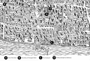
The Erber was almost certainly developed as an aristocratic city residence in the fourteenth century and held by courtly elites until its purchase by the Worshipful Company of Drapers in 1541. Arranged around a number of open courtyards, the property was situated in a densely inhabited area, convenient both to the Thames and to the city markets of Cheapside and the Stocks (see Figure 1).Footnote 8 Unusually, the Erber endured no further subdivision of its spaces in the sixteenth and seventeenth centuries, though it was conclusively destroyed in the Great Fire of 1666. Like most urban courtyard houses, it was formed of one principal house, which was surrounded by a range of smaller tenements and warehouses. The main residence was accessed through a gateway facing onto the busy thoroughfare of Dowgate Hill, marked by two ornately carved posts, which were positioned outside the homes of the city's sheriffs and lord mayors.Footnote 9 Beyond the gatehouse was a small paved courtyard, behind which the Erber's great hall rose up to the west, probably on a vaulted undercroft used as a basement warehouse. Behind the high-status ground-floor hall was a far larger rear yard suitable for receiving goods delivered via a back entrance on Bush Lane. To the north lay another long commercial yard, and to the east was an enclosed garden and ‘herber’ of a very special quality, likely implied in the building's name.Footnote 10 Long galleries at first floor ringed both the backyard and garden, while shop/house tenements filled the west elevation. Approximately 30 to 40 people, many connected to the Iberian trade, might have occupied the Erber at any one time, ranging from elite merchants and their families, factors, servants, to small-scale tradesmen and craftsmen.
Civitas Londinvm, the Agas map (c. 1562). Adapted from http://mapoflondon.uvic.ca/map.htm, accessed 3 Sep. 2017.

Records of the Drapers’ Company suggest that the Company recognized the value of this high-status property, having proactively set out to acquire and preserve it. The Drapers’ decisions relating to the Erber illuminate the ways in which London's wealthiest livery companies worked against densification and overdevelopment of the City's built environment where it suited them. An important motivation in the companies’ resistance to subdivision and the building over of open spaces was the provision of city centre housing for elite merchants with developing links to global trade.
By 1640, entry into the ranks of London's mercantile elite was increasingly restricted, and the wealth of this group was also more concentrated than before. In his seminal book, Merchants and Revolution, Robert Brenner described how the engagement of London's mercantile elite in the new overseas trading companies was key to their appearance as a ‘cohesive and dominant socio-political group’ in early seventeenth-century England.Footnote 11 As mercantile success was ever-more dependent on participation in maritime trading companies, involvement in the governance of livery companies waned, with service in the guilds appearing burdensome and unnecessary.
Urban governance too was reliant on the service of the same men, for livery company membership was foundational to London's political structure, with city leaders drawn from the ranks of the companies.Footnote 12 Service in corporate and civic offices entailed significant financial and time investments, leading many merchants to avoid or decline positions of responsibility. Even so, a study of 140 Jacobean aldermen, demonstrating that theirs was ‘a prodigious wealth by the standards of the day…placing them on a par with major landowners’, reinforces the link between financial prosperity and civic office and underscores that many men did continue to accept positions of authority in the city, even though there was an ever-smaller pool of suitably wealthy candidates.Footnote 13 Holding the office of alderman, sheriff or lord mayor was still seen as a marker of success, as was service as master, warden or assistant in an important livery company.
Despite holding positions of civic office and requiring proximity to other merchants in order to further their business interests, mercantile men were not generally inclined to invest in urban housing. London merchants, contrary to the elites of other European cities, tended to plough back individual profits, often wrought through global adventures, into business or into the acquisition of country estates.Footnote 14 Compared to the new trading companies, livery companies were asset-rich, and, by offering merchants active in London's systems of governance a place of residence, appear to have compensated for the reticence of merchants to invest in local property, enabling the mercantile elite to divert the spoils of their commercial success elsewhere whilst remaining physically in London. Analysis of corporate property management suggests that the livery companies recognized the advantages of retaining appropriately reputable city houses, well located in relation to the transportation of goods and with large halls for the dispensation of honourable acts of hospitality critical to those holding civic office.Footnote 15 East of the city centre had become the preferable location for wealthy merchants, with the opening of the Royal Exchange in 1570 serving to reinforce an eastern bias already present because of the location of Lombard Street, the traditional meeting place for London merchants.Footnote 16 The majority of imported foreign goods were landed close to the city centre to the west of London Bridge, an orientation solidified by the 1559 establishment of the Legal Quays. City houses like the Erber, with storage and office space in proximity to both the Exchange and the quays, would have remained attractive propositions for merchant tenants even up until the Great Fire, with goods stored on site preferable to expensive warehouses located on the outskirts of the city.Footnote 17
The micro-history at the heart of this article reveals that the ‘everyday’ built environment of sixteenth- and seventeenth-century London was certainly shaped by the globally connected mercantile activity of the city elite, but these new trade engagements also had spatial effects on the smaller merchants. For while ambitious city merchants began to reap the rewards of exploratory voyages abroad without leaving London, the lower sort of merchants competed to acquire more storage space to develop their small businesses in the squeezed city environment.Footnote 18 Buildings like the Erber served to alleviate the pressures that global trade placed on the commercial operations of local merchant communities, enabling products sourced or finished locally and regionally to be implicated in the transactions of merchants who mixed traditional exchanges with established international markets with investment in risky new explorations.
Acquisition of the Erber
Like most of the ‘great’ livery companies, the Drapers had already accumulated a substantial estate by the early sixteenth century. Prominent members gifted moderately sized properties to the Company, the rents of which were intended for charitable uses. However, surplus funds and profits were occasionally invested in plate or property.Footnote 19 The Erber was one of two significant direct purchases the Drapers made during the early 1540s, drawing on bequeathed funds to expand the Company estate.
It was the substantial bequest of Thomas Howell, a Draper in the Anglo-Spanish trade and former Company warden, which allowed the Company to benefit from the property fall-out after the Dissolution of the Monasteries and the untimely death of associates of Henry VIII.Footnote 20 Howell was a notable figure in the Iberian cloth trade, ‘among the earliest Englishmen who traded directly with the Spanish possessions in the Caribbean’, according to David Slacks.Footnote 21 Already successful by the 1520s, Howell relocated his business from Bristol to London, exemplifying the growing centralization of the English cloth trade on the capital. Fellow Draper and later master of the Company, George Monox, also transferred to London, trading primarily with Spain and Portugal but in a triangulation of trade with the Levant, East and West Indies. By the mid-sixteenth century, London handled 90 per cent of English cloth exports, leading to the physical decay of cities such as Bristol as regional urban economies contracted. In 1538, Bristol's mayor complained that city buildings, the quay and city walls had become derelict and even ruinous.Footnote 22 Meanwhile, London was struggling with quite the opposite spatial problem, though it too was afflicted by a decline in the cloth-finishing industry in the second half of the sixteenth century. During this time, prosperous members of the Drapers’ Company traded in far more diverse goods because of the failures in the cloth industry, handling items such as wainscots, hops, oil and soap ashes from the Low Countries, paper, prunes and inkhorns from France, raisins from Spain and sugar from Morocco.Footnote 23
During the relatively favourable economic conditions of the 1540s, the Drapers’ Company acquired the Erber. The property's size, location and reputation made it suitable for the Company's purposes. Referred to as ‘The King's Place’ on account of its royal ownership, it was home to a string of important courtiers including the Le Scrope, Neville and Plantagenet families from 1341.Footnote 24 On Henry VIII's accession to the throne, the new king gifted the property to Margaret Pole, countess of Salisbury, though she was beheaded on grounds of treason in 1541; her unfortunate execution was presided over by Lord Mayor William Roche, a Draper prominent in the Spanish trade and to whom Thomas Howell had been apprenticed. Roche exported English cloth to continental Europe in exchange for goods such as oil, iron, salt and wheat.Footnote 25 When the Erber reverted back to the king, it was quickly purchased by the Drapers’ Company and Roche himself was granted a tenancy of a tenement on the site in his later years.Footnote 26
Less than a year after purchase of the Erber, in March 1543, the Company acquired the extensive former residence of Thomas Cromwell. Located on Throgmorton Street in Broad Street Ward, the courtyard house and hall at the core of the property became the Drapers’ new corporate headquarters.Footnote 27 The site consisted of several large tenements, intended for the ‘many of this said fellowship that do lack houses to dwell in’.Footnote 28 The size and value of the properties at Throgmorton suited the purses and activities of those in the upper tier of the Company, although no one house matched the prestige and size of the Erber's principal house.Footnote 29 The Throgmorton model illustrates the development of ‘mid-sized clusters of closely-grouped upper-class houses’ which followed the dissolution of monasteries in London.Footnote 30 The potential to group neighbours with shared business interests and networks together appealed to prosperous merchants, and the Company expected Throgmorton to prove a ‘both profitable and pleasant’ investment.Footnote 31 For near-enough a century after acquisition, vacancies in the Erber and Throgmorton properties were nearly non-existent suggesting their instincts that these would be productive purchases were proven right.
Soon after its purchase in 1543, Drapers’ Hall was well inhabited by moderately successful merchants of the Drapers’ Company, many of whom were associated with the Merchant Adventurers (established 1407), a leading medieval trading organization with a monopoly on English semi-finished woollen cloth exported to Germany and the Low Countries. By the beginning of the seventeenth century, tenants included merchants of the highest order and civic standing, many involved with new trading companies making first direct contact with markets in Asia and the Americas. In the 1560s to the 1580s, tenants of the hall who were Drapers and Merchant Adventurers were also important members of the Muscovy Company, Turkey Company and Venice Company. Of these tenants, Sir Martin Calthorp, alderman and lord mayor in 1588–89, is the most notable.Footnote 32 One of the longest-standing residents at Drapers’ Hall in the early seventeenth century was William Towerson, Skinner and prominent member of the Spanish Company, who took up a tenancy from 1606 until at least the 1630s.Footnote 33 His neighbours at the Hall included Sir William Cockayne (Skinner, Spanish Company, Eastland Company, Levant Company, Merchant Adventurer), Sir William Garway (Draper, Levant Company, Turkey Company, East India Company), Sir Henry Garway (Draper, Levant Company, Greenland and Russia Company, East India Company, alderman, lord mayor) and Sir Morris Abbott (Draper, Levant Company, East India Company, alderman, lord mayor).Footnote 34 Between them, these men had direct trading connections with the Low Countries, France, the Iberian Peninsula, Muscovy, eastern Europe, Barbary, Germany and the Levant, as well as connections to the East and West Indies and the Americas through their trading partners. Tenants of the Erber and Drapers’ Hall who were members of the Drapers’ Company, and served as sheriffs, aldermen and lord mayors, tended to be most closely involved with the Spanish Company (established 1530 and 1577).Footnote 35 This is significant, for Brenner suggests that the Spanish trade ‘served as the prototype and springboard for the developing trades with Africa, the Mediterranean, and the East’.Footnote 36
One of several large courtyard houses owned by the city companies, and favoured by merchant political elite, the Erber functioned as a local incubator for trade on expanded scales. Properties of this type could integrate housing with a company hall, an arrangement that, while not entirely new, became notable in the sixteenth and seventeenth centuries. Such urban complexes could also prioritize accommodation for the master of the Company or a similarly prominent mercantile tenant. Mercers’ Hall (expanded accommodation acquired in 1542) and the Skinners’ Hall (partially rebuilt in 1595 to create a dwelling house appropriate for a lord mayor from their Company) are cases in point.Footnote 37 In the fifteenth century, when some prosperous merchants built city houses for themselves, Crosby Hall, set deeply back from Bishopsgate and following the courtyard form, was built for the master of the Grocers’ Company and wool merchant, Sir John Crosby. It was later occupied by three sixteenth-century lord mayors and one sheriff, most of whom held important mercantile interests. Crosby Hall served as the headquarters of the East India Company in the 1620s and 1630s.Footnote 38 Houses such as these show that particular city buildings could be retained for mercantile use over a long term, flexibly intermingling or adapting to serve commercial, corporate and domestic uses.
Buildings fashioned as livery halls were frequently used to host functions related to civic and trading corporations. The overlapping use of these spaces indicates the intermingling membership of these groups and the benefits reaped from their connections. For example, the Mercers’ Hall reserved a small room including a locked press for storage of monies and writings for the use of the Merchant Adventurers in the sixteenth century.Footnote 39 Meanwhile, in 1557, Drapers’ Hall was used by the Muscovy Company to host an important dinner with the Russian ambassador which marked the end of a period of negotiations regarding the Anglo-Russian trade. Although the Muscovy Company had its own base in the port of London, Drapers’ Hall provided the more appropriate setting for an impressive show of hospitality. Two leading members of the Drapers’ Company at the time were investors in the Muscovy Company and led the preparations.Footnote 40 Livery, civic and trading corporations were not just structurally intertwined but spatially bound together.
Though corporate records suggest that pre-fire courtyard houses maintained by the city companies were an important building typology in London, only fragmentary evidence of their architectural form and arrangement has survived. Detailed drawings of such buildings are rare; even more unusual is to be able to relate this information to their adaptation and occupation over time.Footnote 41
The principal drawing of the Erber was likely produced during a legal challenge to the Company's ownership of the property heard in the Court of Exchequer in 1596–7.Footnote 42 The challenge was raised on account of property exchanges completed long before the Drapers purchased the Erber but still grounds for contestation of their corporate rights. The matter was in fact settled by the queen in 1598 when she ruled in favour of the Drapers, overruling her own searcher, the notorious William Typper.Footnote 43 Beyond the drawing, the Drapers’ Company's administrative records reveal in some depth developments to the Erber from 1541 onwards. The Renter Warden Accounts and Minute Books allow for the reconstruction of particular fragments of the building in surprising detail with identification of tenants and their building work.Footnote 44 These source also offer insight into the discussions and decisions of governors of the Drapers’ Company as they managed corporate property. The concerns and tensions implicit in these documents shed light on the contribution of the Company to changes in the urban environment, and on the reasoning behind corporate action or inaction.
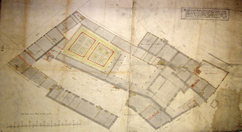
The large coloured drawing of 1596 presents the Erber as a characteristically medieval urban mansion house constructed primarily of thick stone walls, with brick and wood infill (see Figure 2). Beyond the principal house, the plan reveals a network of internal courtyards and garden spaces. The quality of the quadrant garden is carefully rendered and embellished by the surveyor, indicating this was a space of the utmost prestige and leisure. Lined with stone tenements and warehouses, the spacious long yard to the north-east is labelled ‘Scott's Yard’. To the south of the main hall sat an open storeyard at the corner of Dowgate Hill and Carter Lane. A series of modular storage spaces and stables lined the lane. Through close observation of the form and building materials used, significantly, the drawing suggests that the courtyard arrangement was upheld throughout the Drapers’ ownership. Yet it also reveals that parts of the Erber underwent change and expansion over time in order to remain a reputable house for a civically minded merchant of the highest calibre, as well as supporting the commercial endeavours of more provincially orientated merchants.
Anon., the Erber plan, 1596 (DCA, A X III 165). Reproduced with the kind permission of the Worshipful Company of Drapers.

The investigation that follows examines the occupation and development of the house in three parts: the principal house, the storeyard and finally the warehouses and constructions that built up along Carter Lane. It argues that the Drapers preserved the ‘pleasant’ qualities of the principal house to serve its wealthy mercantile leaders engaged in the performance of significant civic duties but with their eyes also on prizes wrought by breaking the stranglehold of the Spanish–Portuguese trading empire. The Drapers’ decision to maintain a large storeyard at the Erber also suggests that the Company sought to support its members’ own building work elsewhere in the city, ensuring materials were on hand to facilitate the making of new storage spaces in rear yards of existing houses which would accommodate expanding global trade. Lastly, the investigation considers the conditions under which the Company endorsed proactive development of their properties by mercantile tenants of the lower sort, for ancillary activities and regional supply chains were essential to the growth of London's trade, especially in cloth after the fall of Antwerp.
Profitable and pleasant
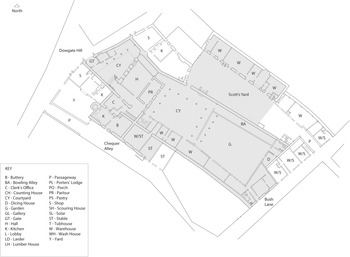
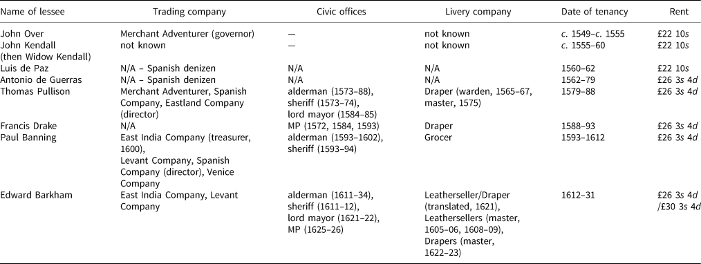
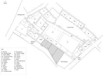
The Drapers ensured near continuous lets of all portions of the Erber for decades after its purchase. Between its acquisition and subsequent destruction in 1666, the principal house was occupied by a string of important London merchants associated to the Company, although not always drawn from its ranks. By providing suitable city centre houses for ambitious merchants belonging to an increasingly globally orientated socio-economic network, who often also served in corporate and civic offices, the Company secured a stake in the future prosperity of London. Tenancy records reveal that from c. 1540 to 1630 all but one tenant of the principal house (see Figure 3) can be directly linked to exchanges on an international scale and many, particularly in the latter half of the century, served as city officers (see Table 1).
Re-drawing of 1596 plan by author. Extents of principal house highlighted.

Residents of the principal house of the Erber compiled from DCA, RA series.

The first tenant installed in the principal house of the Erber was John (or Jan) Over, former resident of Antwerp, in which city he acted as leader of the Merchant Adventurers. He was described by two Dutch and Italian merchants during his Antwerp tenure as ‘a man of good fame, realistic and of means’, yet he does not seem to have been a member of the Drapers.Footnote 45 For those operating at an international scale, membership of a London livery company was not necessarily synonymous with membership of a well-established trading corporation such as the Merchant Adventurers, though a level of overlap between corporations was advantageous, allowing the benefits of one group to be more easily transferred to those in another. Given his important role in the Antwerp cloth trade, and his tenancy of a property belonging to the Drapers’ Company, it seems highly likely that Over continued his involvement in the import and export of woollen cloth to the Low Countries and Germany whilst in occupation of the Erber.Footnote 46
The next few tenants of the Erber's principal house indicate that, at least in the mid-sixteenth century, the Company was willing to use corporate property to nurture the extending networks of trade increasingly integrated through its leading members. Thomas Howell's fortunate bequest of 1538, made possible through his extensive trade with Spain, specifically Seville, demonstrated that some prosperous members of the Company were already deeply engaged in Anglo-Spanish trade in the early decades of the sixteenth century. The Spanish association came into sharp relief at the Erber in the 1560s and 1570s, when two merchants and ‘spies’ for the king of Spain consecutively occupied the principal house. Howell's bequest, the strength of the Spanish–Portuguese trade at this time and the related activity of later tenants suggest this must have been a profitable and likely strategic let at the time the tenancy was granted, even though the direct link between these merchants and the Drapers is not known.
It is clear, however, that both Antonio de Guerras and Luis de Paz became agents for the king of Spain sometime between 1540 and 1560 whilst resident in London.Footnote 47 For de Paz and de Guerras, it appears the house was a cover, suitable both for the operation of their business activity as well as the representation of their status as prominent, respectable mercantile men. De Paz's tenancy of the Erber began in 1560 and it is said he operated ‘in the guise of a merchant’ when he was sent by the Spanish ambassador from London up to Scotland in 1564. De Paz was followed in 1562 by de Guerras, who was an active Spanish merchant in London from at least the 1540s. In 1545, for example, he was importing French goods on a ship called the ‘Anna of Barsalana’.Footnote 48 De Guerras’ trade is recorded in 1544 as ‘in goods’, and in the years following he lived with a number of servants, most of Spanish or Portuguese origin.Footnote 49 De Guerras’ connection to the triangular trade between London, Iberian merchants and East Indies or American markets can also be inferred from his association with Hector Nunez, who was sent to negotiate with the Drapers on behalf of de Guerras in April 1570.Footnote 50 Nunez was a Portuguese Jewish convert to Christianity who practised both as a physician and merchant in London for over 50 years. He traded with Spain, Portugal and Brazil, investing in adventures to Africa and the Americas, and, by 1582, Nunez lived with his family, three clerks and two black servants in a house on Hart Street in London.Footnote 51
De Guerras secured the transferral of de Paz's tenancy by committing to spending £100 on repairs. But the extent to which he honoured his promise is unclear and the Drapers’ records imply that little work was undertaken.Footnote 52 Soon after his arrival, however, the tumultuous relationship between Spain and England caused the alien merchant to spend the first of two periods of imprisonment in the Tower of London under charges of spying. In 1569, agents of Queen Elizabeth seized the Erber and the house was ransacked, drawing unwanted attention to the property. Catholic images and gilt carvings taken from the house were paraded through the streets of London on a crowded market day. In a highly visible act of incitement against the Spaniards, the controversial spoils were separated in half and burned outside the Erber on Dowgate Hill and in an unspecified marketplace (probably nearby Cheapside or the Stocks).Footnote 53 On release from the Tower, de Guerras remained in self-imposed house arrest ‘without daring to appear on the streets’ for the next three years.Footnote 54 During this time, the Company suspected further neglect of their valuable property; the promised reparations remained undone and Company officers were denied entry by de Guerras. The merchant's second imprisonment in the Tower soon led to his dismissal from England altogether in 1570 and the property was then granted to future lord mayor and Draper Thomas Pullison. Such was the extent of disrepair that Pullison agreed to rebuild and alter the property within seven years for a sum of 1,000 marks.Footnote 55 De Guerras reportedly died in relative obscurity in Tarragona, whilst de Paz may have been one of the Knights Hospitaller who died in the 1565 Siege of Malta, serving Philip II.Footnote 56
After 19 years in the hands of Spanish merchants, in 1579 the Erber's principal house was duly transferred into the hands of London merchant, Thomas Pullison, who continued to connect the Erber with Iberian trade through his importation of Spanish wool and directorship of the Spanish Company.Footnote 57 But his interests were more diverse than this. In the same year, for example, he also took possession of lead shipped from Hull to London, for onwards sale to Rouen, France.Footnote 58 In the early 1580s, he backed Edmund Fenton's expedition to the Molucca Islands via South America in 1583, and was a director of the Eastland Company.Footnote 59 He was the first of several tenants who entered the Erber just before, or even during, their first year in an enlarged civic role. Pullison himself secured a lease only a couple of years before his term as lord mayor.Footnote 60 Unlike de Paz and de Guerras, the Draper seems to have made good on his promise to renovate the property. John Stow noted that the Erber was ‘new builded’ by Pullison, though the precise nature of the changes made to the existing building is unclear.Footnote 61 The 1596 plan offers some evidence of the construction of a new kitchen to the south of the great hall, presumably to enable the hospitality intrinsic to the mayoralty. But little else suggests any significant internal reconfiguration on the ground floor. Typical for those serving in high civic office, during his term as lord mayor, Pullison was granted special rights to the water conduit at the top of Dowgate, seen on the Erber drawing. This enabled a private quill to pipe water into his house, again aiding the dispensation of hospitality. The condition for this privilege was that he personally bear all the costs of installation.Footnote 62 After Pullison, well-known captain and honorary Draper, Francis Drake, was admitted to the principal house after the defeat of the Spanish Armada at Plymouth and his expedition to Cadiz. In 1589, he led an expedition to Portugal whilst holding the tenancy of the Erber and vacated the property on completion of a second term serving as MP in 1593, having sat on a number of committees concerned with Devon cloth amongst other things.Footnote 63 Drake was closely connected to a number of Drapers prominent in the international trading companies through their promotion of his adventures. Among them were men such as William Garway, a tenant at Drapers’ Hall. Exemplifying the sort of activity these men were engaged in, Garway's privateering and trade ship the Ascension was deployed against the Spanish Armada, then proved to be the first English ship to defeat the Portuguese in order to break into their connection to the Far East.Footnote 64 The Erber was surely utilized for Pullison's trade in wool and other goods, often connecting to global exchanges on some level, and its proximity to a cluster of ambitious Drapers may have aided Drake in his continuing kinship with London's elite merchants, gaining their continued support for his adventurous exploits.
Drake's occupation of the Erber was followed by the tenancy of ‘city magnate’ Paul Banning, an associate of Pullison from the Spanish Company.Footnote 65 A member of the Grocers’ Company, Banning's entry to the Erber corresponded with his election to the office of alderman in the year 1592–93. Though moderately involved in his livery company and urban governance, Banning's focus was on his commercial exploits. A member of a ‘trans-national Anglo-Spanish merchant community’ and head of a large household of employees and servants, a handful of whom were of African origin, Banning's commercial activities accounted for 94 per cent of imports from the Levant.Footnote 66 Whilst Pullison, as elder merchant, was still a member of the long-established Merchant Adventurers, whose influence was fading, Banning took up with the new East India Company, whose star was rising. Despite these generational differences, both Banning and Pullison were simultaneously members of livery companies, city officers and important leaders of several newly formed trading companies. Thus, to differing degrees, the pair appear to represent men of the new mercantile elite, foreshadowing the explosive expansion of the commercial exchanges of many London merchants and their trading companies in the seventeenth century.
The Erber's centrality to the political life of London was undiminished in subsequent decades. Tenants continued to serve in high civic office whilst remaining engaged in new trading adventures as investors, though perhaps to a lesser extent than before. East India Company investor Edward Barkham's tenancy in 1611 coincided with his admission to the office of sheriff, which was followed by a term as lord mayor in 1621–22 while still in occupation of the Erber.Footnote 67 Later residents included Edward Bromfield, lord mayor in 1636–37, who was a leading figure in the London Society of Soapboilers, an industry that relied heavily on imports from the Baltic and Scandinavia, and Richard Chiverton, lord mayor in 1657–58 and governor of the Eastland Company.Footnote 68
The storeyard
The Erber's principal house continued to serve as a place of residence to merchants occupying high civic office, effectively supporting men in performance of their civic duties, especially in regards to hospitality, thereby helping to uphold the city's honour. Importantly, the building offered functional spaces that also facilitated the business of trade, namely a suitable range of warehouses and places of storage. Logistics for the processing and exchange of goods within the wider city were, however, not always straightforward. Disputes between porters and merchants were not unusual, existing spaces to receive and send out traded things were in greater demand, and roads were increasingly clogged with traffic.Footnote 69 The Erber simultaneously provided prestigious interior spaces that were insulated from building encroachments whilst alleviating pressure on merchants who required well-located storage spaces in the development of its outer edges.
The Erber was conveniently located close to Thames Street, an important east–west trajectory through the city, well-used by porters and carts. Congestion on routes such as Thames Street was frequent as ever-more goods in transit, such as currants, wine, wood, oil and wool, were ferried from the riverside area to mercantile houses. London chronicler Henry Machyn wrote about the shocking death of a carter in 1562 by recalling how a glut of carts that had halted traffic on the road he was travelling on caused one road user's anger and frustration to turn murderous.Footnote 70 Running roughly parallel to Thames Street and along the Erber's southern boundary, Carter Lane was likely a resting place for the city's porters, carters and their related tackle. The Salisbury records from the early sixteenth century noted temporary fastenings for horses, stables and licences for rented individual carts. Latterly, de Guerras and Barkham ensured existing stables in Carter Lane, then not allied to the Erber, were included in their leases, so the association of this passage with transportation was maintained even if its character was somewhat in flux.Footnote 71 In the context of the crowded city, the position of the Erber, at the top of Dowgate Hill, off Thames Street, situated it fairly centrally. Its location enabled it to act as a nodal point between regional goods coming in from the west, locally manufactured products around Dowgate itself and global imports coming in from the east. Dowgate Hill also connected up through Walbrook towards the main central markets and other merchants’ houses.Footnote 72
There is no evidence which distinguishes precisely how the warehouses of the Erber were used, but the configuration of a multitude spaces around the yards indicates that on-site storage was a priority for occupiers of the principal house. Subsidiary tenements, multiple entrances and connected courtyards enabled the Erber to function as an effective ‘live-work’ space prudently attuned to mercantile needs. An entry gate between the Erber's backyard and Scott's Yard allowed for fluidity between the two distinct spaces, likely facilitating the articulation of differing patterns of use. A number of tenements and warehouses in Scott's Yard were included in the lease of the principal house.Footnote 73 Goods might have arrived via Bush Lane into Scott's Yard for checking by factors before more valuable or delicate merchandise was directed to the rooms surrounding the Erber's first rear courtyard.Footnote 74 A rare 1577 inventory of another city mansion house held by a mercantile lord mayor records that a great warehouse, a fish house and a spice house were all parcelled into the property. John Schofield's archaeological study of a mercantile Grocer's property by the Thames concluded ‘that rooms and spaces were carefully distinguished by function in these house-and-business complexes; and that various solutions for the increasing problem of warehouse storage were being attempted’.Footnote 75 For, as well as absorbing an ever-increasing proliferation of imported and exported goods, city spaces may have become more specialized around trading activities and the containment of goods.
Although records offer little direct insight into the changing use of the Erber's storage spaces, it is clear that other buildings held by the Drapers’ Company were increasingly subdivided and expanded. Tenants of all sorts tried their hand in adapting properties to extend their commercial capacity, creating new doorways, partitions and cellars to accommodate the reception, storage and dispensation of goods. Garrets and penthouses were added and open yards were covered over by low warehouses.Footnote 76 The importance of maintaining spaces that were well built and secure in order to protect merchandise also led to improvements. Existing rooms were rebuilt in brick, given heavier doors and locks, and windows were fitted with extra iron bars, to ease concerns.Footnote 77 While space above ground was frequently covered over and buildings grew taller, the city inevitably developed its underground capacity too. John Evelyn evocatively observed the valuable subterranean network of spaces that lodged beneath many of London's buildings as he walked around in the post-fire city.Footnote 78
The adaptation of existing buildings, often to accommodate more traded goods as much as to improve domestic spaces, was reliant on the acquisition of building materials at a reasonable price. Recognizing the benefits of retaining a quota of materials ‘in store’, the Drapers sought to serve its members by increasing its capacity to stockpile building materials for corporate and personal use. In 1555, the Company elected to create a storehouse, enlarging the ground-floor gallery of its Throgmorton Hall to ‘lay in boards and timber’. In the same year, the cellars below the gallery were extended and this space was given over to tenants of the Company's capital house at the Hall.Footnote 79 The Drapers were not alone in developing such spaces. In the 1550s, the Merchant Taylors also enclosed a new storeyard within the boundary of their hall and the Mercers too had appointed a storeyard or ‘timberyard’ so that materials could be purchased at ‘as convenient and reasonable price as may be had’.Footnote 80
In 1557, a site at the Erber was surveyed for the development of a larger storeyard. Four experienced Drapers were asked to ascertain whether the ‘void place at Dowgate beside the Erber’ ‘will be a mete place for a store house for this fellowship or no’.Footnote 81 Several years later, the Drapers finally resolved to reclaim the yard from Brown, their ‘tenant-at-will’ whose occupation could therefore be revoked at short notice. The uncooperative Brown was forcibly evicted after a case was lodged against him; the jury and witnesses notably took the decision after a dinner at Drapers’ Hall.Footnote 82 Soon after, a bricklayer and five labourers constructed a new boundary brick wall and the base of the storehouse. The Company's Carpenter, and day-to-day overseer of the storeyard, subsequently finished the building frame.Footnote 83 A ‘great gate’ of brick faced onto Dowgate, in which stonemason Phillip Paskin set up a stone carving of the Drapers’ Arms. Over the following decades, further constructions progressively filled more of the yard to accommodate the activity of carpenters and the stockpiling of building materials. By 1590, the Company had passed on its lease of the storeyard directly to William Bradshaw, the Company's Carpenter, showing just how comfortable the arrangement had become with his oversight.Footnote 84 Tools were stored on site, wainscots were deposited in penthouses and ‘great logs of timber’ were temporarily lodged outside the gate ready for ‘slitting’ and sawing across an excavated pit.Footnote 85
Leaders of the Drapers’ Company utilized their personal trade connections in service of the Company, frequently buying in materials for storage in the yard for eventual corporate use or deployment by other members. William Megges, warden of 1578–79 and 1582–83, imported 200 wainscots for the refurbishment and upgrade of the Company parlour and roof at the Throgmorton Hall, coinciding with the construction of his own house in Whitechapel.Footnote 86 His name consistently appeared in the port books of London in relation to the importation of wainscots, hops, oil and soap ashes from the Low Countries.Footnote 87 In 1579–80, an interesting tally or ‘memorandum’ outlined those implicated in the use of materials stockpiled in the storeyard. Five of the nine debtors were Drapers and also members of the Company's governing court. Among many examples, Thomas Pullison was recorded to ‘oweth upon this account’ weather board, hearth lath, double quarters and ragged stones. Mr Thorowgood, also a Draper and warden, ‘owed’ a similarly large quantity of materials. Another warden, Mr Heardson, owed £5 17s spent on quarter boards used on housing ‘for the poor of the company’.Footnote 88 Company stores therefore ensured mercantile members had quick access to building supplies for both corporate and private projects, on the condition they return in kind or cash the value of the goods used. It was also expected that these men would use their trading connections and business acumen to acquire materials for corporate use on favourable terms when needed.Footnote 89 Membership of one of the many livery companies implicated with trade also ensured valuable access to corporately maintained tacklehouses and porters appointed to assist company members in unloading and transporting goods from the riverside.Footnote 90
The equilibrium between corporate and individual gain, implicitly held in balance in these corporate spaces, could nevertheless be unsettled. In 1638, warden, Merchant Adventurer and French Company member Thomas Bewley was recorded to have surreptitiously used the cellar under the gallery of the Company Hall to store wine, almost certainly imported from continental Europe, for commercial purposes.Footnote 91 Carts rattled continually through the highly prestigious courtyard and, as the cellar was often used late into the night with candles, the fire risk this posed was a pressing concern. Having acted out of ‘extreme necessity’, Bewley nonetheless left the cellar after the Court of Drapers ordered him to do so. The warden was not further reprimanded for his indiscretion.Footnote 92 This incident illustrates the high value of secure storage spaces and the temptation to capitalize on the spatial privileges of corporate office in pursuit of personal gain.
Middling merchants
In the densifying built environment, merchants of many sorts recognized the potential of marginal land to support the development of profitable enterprise. The Drapers' accounts show that Carter Lane was narrowed as constructions built up along its edges in a response to the struggle for more city centre storage spaces. Here, citizens of the middling sort, whose involvement in domestic distribution channels supported wider trade networks, acquired and built on small sites facing onto the Lane. Their activity embeds at an intensely local level Stow's assertion that London was ‘the principal store house, and staple of all commodities within this realm’.Footnote 93 For as global trade expanded so did domestic exchanges; London became more central to English trade and commerce than ever before. Middling merchants primarily involved in domestic exchanges competed for storage space in the city or sought to create it, just like those merchants trading at a global scale.
The progressive enlargement of existing buildings and construction of new storage spaces on the Carter Lane site began with a single-storeyed warehouse, a tenement called ‘the Chequer’, and a void space or garden facing onto the Lane (see Figure 4).Footnote 94 Initiatives by middling Merchant Taylor Thomas Jackson and his associates on this side street indicate how the Drapers allowed for profitable development of their properties if it did not interfere with its prized ‘pleasant’ spaces.Footnote 95 Smaller-scale commercial activity could shape marginal spaces and operate in close proximity to more prestigious spaces. The Drapers, like other livery companies at the time, upheld through these projects the diversity and complexity of the city's built environment. Moreover, they implicitly supported the emergence of London as a critical centre for mercantile exchanges at both provincial and the global scales. Indeed, the two were conceptually and spatially interlocked.
Re-drawing of 1596 plan by author. Probable site of Jackson's development highlighted. The blank space on the 1596 plan was in fact built upon, but unillustrated, owing to its divergent ownership history.

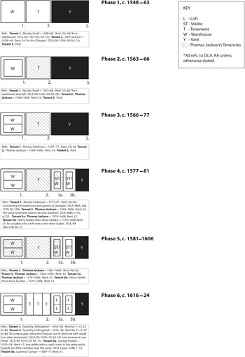
The first expansion on Carter Lane occurred in the 1560s and was undertaken by Nicholas Small, a Clothworker. Small then added another floor to his existing one-storey warehouse (marked site 1 on Figure 5), which effectively doubled his rent.Footnote 96 The internal spaces of this building were then subdivided and added to by the next tenant, Nicholas Parkinson, in the 1570s. As the warehouse expanded in size once more, the Drapers imposed a further rent hike, much to Parkinson's dismay. After threatening to abandon his let, Parkinson appears to have acquiesced, demonstrating that the Drapers held the upper hand.Footnote 97 This proactive tenant may also have been responsible for the building of two new stables and lofts, which had been constructed to the west of site 1 and partially depicted on the 1596 plan.Footnote 98 Another lease for the same section of property in 1648 describes the same accommodation as ‘one stable with a coach room in the same and a hayloft and little chamber over the same’, indicating that the space had experienced further adaption by the mid-seventeenth century.Footnote 99
Diagram indicating the progression of development on Carter Lane. Upper floors are represented by internal boxes.

The detail of Thomas Jackson's accumulation of accommodation shows the perseverance and opportunism that enabled middling-level merchants to secure enlarged commercial spaces. In 1563, Jackson began his tenure at the Erber as lessee of a single tenement, paying £4 in rent. The tenement (marked as site 2 on Figure 5) had been formerly occupied by John Jackson, possibly a relation.Footnote 100 Over a 40-year period, Thomas Jackson worked to expand his accommodation from this base. Notably, at no point did Jackson appear to have constructed a shop in his building activity, and the location of his warehouses on such a subsidiary street suggests his business as a Merchant Taylor was not in retailing, but likely implicated in a supply chain which supported wholesale trade.
Thomas Jackson began conglomerating a larger proportion of the accommodation either side of his tenement in 1579. He secured at the time a lease of ‘the small storeyard at Dowgate’ (site 3), an addition to the ‘great’ storeyard facing onto Dowgate Hill, for 40s per annum. He wasted no time in petitioning the Drapers for licence to build on his newly acquired land. Jackson pursued this project as a joint venture with Henry Fawlks, a local grocer, also implicated in the development of land in Whitechapel.Footnote 101 Representing the partnership, Jackson ‘made offer to new build the stable which would cost him about the sum of £10’ upon the ‘void ground or old storeyard’.Footnote 102 Drawing on descriptions from later years, the building work undertaken by Jackson and Fawlks was alternately referred to as ‘rooms in the yard’,Footnote 103 ‘diverse other rooms and lofts in the yard with part of the new building’Footnote 104 and ‘the new building and store yard’.Footnote 105 Some element of the open yard thus must have remained despite the construction of enclosed storage spaces. Two years after Jackson's development of the small storeyard, he acquired the warehouses and rooms previously developed by Parkinson to the west of his original tenement (site 1). As the tenant or co-tenant of all three sites, and with a number of servants working for him, Jackson maintained his aggregated group of housing, warehouses and stables, totalling a yearly rent of £8 6s 8d, for more than 20 years until his death in 1604.Footnote 106
A further subdivision was made after Jackson's death, which created three separate properties on the site of his former tenement, likely let separately for greater profit.Footnote 107 In this way, property on Carter Lane was consistently multiplied and compartmentalized, capitalizing on the location of the Erber and the ‘slack space’ surrounding it. Stow's Survey noted that Carter Lane had become known as Chequer Alley by 1603, the change from Lane to Alley carrying with it negative connotations of poor-quality overdevelopment.Footnote 108 The exact business exchanges of those on Carter Lane have not survived and Thomas Jackson's origins, in London or otherwise, are untraceable. But middling merchants like him often relied on county connections and evidence from Drapers’ Hall indicates the desirability of a well-situated London house for those connected to the regional cloth trade. John Draner was a Draper and tenant of a small tenement at Drapers’ Hall from the 1540s until 1564. He was the son of a wealthy clothier involved in the Kentish cloth trade, specifically trading Weald broadcloths with London merchants. Draner's neighbour was John Quarles (d. 1578), a warden of the Drapers’ Company and Merchant Adventurer, whose business acumen was passed onto his son, also John Quarles, a merchant who exported cloth through his factors in the Low Countries. At least some of these cloths were sourced from Kent and finished in London.Footnote 109 No inventory survives for the houses of Draner and Quarles, nor documents to establish a formal commercial link between the two families. But Draner's tenancy at Drapers’ Hall, far from his family home in Kent, suggests a London base was increasingly beneficial to those provincial clothiers seeking to connect the regional economy to more distant markets through the London wholesale merchant elite. Whereas Draner's father remained in Kent for his lifetime, accessing to imports and exports through Rye, his son deemed it necessary to relocate to London and rent a house amongst globally engaged merchants.
Conclusion
Few would contest Derek Keene's assertion that trade was ‘the prime force which conditioned the reordering and rebuilding of the [post-fire] city’ of London.Footnote 110 Yet Brenner cautions that this spatial reorganization needs to be seen in a wider context, for ‘long-term processes making for the transformation of English trade, at work since the middle of the sixteenth century, were accelerated rather suddenly’.Footnote 111 This article similarly proposes that the proliferation of small-scale adaptions to buildings held by livery companies in the sixteenth and early seventeenth centuries was a precursor to the large-scale rebuilding of the city after 1666. Close observation of the Erber reveals something of the incremental developments that characterized the densifying landscape of the city. Lofts, warehouses, garrets, cellars and storeyards were progressively built into and hewed out from the existing building stock and developed as extensions and reappropriations of spaces already loosely programmed and underutilized. The case of the Erber supports the view that the spatial and institutional patterns and infrastructures for economic growth were already established by 1640. Embedded within the urban environment, the accumulation of such ‘tweaks’ to existing structures facilitated the operation of new trading ventures from the heart of the city. The use and occupation of the Erber demonstrates how a range of urban actors not only responded to global economic forces but negotiated them at intensely local scales, balancing commercial and civic responsibilities. London was therefore already set on a trajectory of recalibration around ever-increasing scales of mercantile activity long before the Great Fire forced a more obvious transformation of the built environment.Footnote 112
In sum, the development and occupation of the Erber under the Drapers’ Company suggests that the global enterprise of London's elite merchants was intimately connected to multifunctional urban spaces. Since the late fifteenth century, many livery companies had built up significant city property portfolios by way of bequest and purchase. In ensuring the provision of buildings carefully attuned to the social and commercial needs of a variety of citizens, the ‘great’ livery companies worked to maintain and indeed amplify the overlap between membership of trading companies, livery companies and, ultimately, service in urban governance. The spatial substructures of global trade were, however, often unseen. The spaces which supported profitable commercial enterprise were discretely embedded in house-and-business complexes or constructed along narrow alleys. Micro-histories of sites such as that of the Erber allow for the strong ties between globally orientated mercantile exploits and high civic office to be unpicked, and reveal some ways in which the built environment adjusted to new scales of trade.Footnote 113 In the densifying city, the Drapers’ acquisition and tenancy of high-quality reputable courtyard buildings like the Erber indicates that such diverse properties could serve to bind elite merchants back into their local contexts. Meanwhile, like companies such as the Mercers and Merchant Taylors, the Drapers recognized the wider need to support its members’ own building work and responded by ensuring a large storeyard with materials on hand to facilitate the making of new storage spaces suitable for a global city. Further, the Company endorsed proactive development of their properties by mercantile tenants of the lower sort, whose domestic exchanges could directly and indirectly support the activity of commercial globalization. In this way, the history of the Erber highlights the dialogic relationship between economic developments on global scales, and the social, political and spatial circumstances of individual merchants within ever-more densely occupied early modern cities.