


Introduction
This study examined how residents in Hoi An Ancient Town, Quang Nam province (present Da Nang cityFootnote 1), Vietnam have adapted their everyday lives to cohabit with floods and what these adaptations reveal about cultural heritage resilience. To achieve this goal, this study: (1) traced the historical and cultural significance of floods in shaping the local lifestyle, (2) examined the importance of traditional knowledge and modern practices of flood management, and (3) assessed how resilience is embedded in the ability of Hoi An residents to integrate adversity into social and cultural life. These dimensions engage with a broader shift in urban flood management philosophy from resistance to resilience (Schielen and Roovers Reference Schielen and Roovers2008) and resonate with larger efforts to address flood risks through a combination of structural and engineering measures, non-structural strategies, and approaches that emphasise living with nature (Khalif et al. 2023; Liao Reference Liao2012; Liao et al. Reference Liao, Le and Van Nguyen2016, Parker Reference Parker2000). However, studies on living with floods have predominantly been conducted in rural and remote areas of developing countries (Berkes Reference Berkes2007; Khalif et al. 2023; Liao et al. Reference Liao, Le and Van Nguyen2016), leaving a gap in understanding how this approach functions in long-established urban environments, such as Hoi An Ancient Town, Vietnam (Fatorić and Seekamp Reference Fatorić and Seekamp2017; Nguyen and Baker Reference Nguyen and Baker2023a; Orr et al. Reference Orr, Richards and Fatorić2021). Therefore, this study broadens knowledge of how communities integrate traditional practices with modern engineering measures by embedding floods into their cultural and social fabric and expands understanding of how long-established urban settlements have managed flooding over time. This inquiry is especially urgent given Vietnam’s recent experience with Typhoon Yagi, the most powerful storm to strike northern Vietnam in 70 years, which flooded 20 of 25 provinces, claimed 292 lives, and left 39 missing in September 2024 (Dinh Reference Dinh2024).
Hoi An Ancient Town is one of the most ancient trading towns in Vietnamese history. Inscriptions on a stone stele at the Ngu Hanh Son (Marble Mountain) in the coastal city of Da Nang, Vietnam suggest that the town presently known as “Hoi An” dates to the late 16th or early 17th century (Tran Reference Tran1991). The town is situated on the north bank of the Thu Bon River, close to its mouth where it flows into the Eastern Sea at the Cua Dai estuary (Figure 1). This proximity to water makes Hoi An vulnerable to annual flooding, which is vividly represented in archaeological and historical records (Nguyen et al. Reference Nguyen, Mai, Phan and Baker2024). In response, residents have demonstrated a long-standing endurance of floods over many generations. Indeed, managing flooding has been a collective and essential responsibility for the people of Hoi An throughout the history of the town. Residents have long relied on nature-based knowledge to cohabit with floods and foster a harmonious relationship between humans and nature. This traditional knowledge has recently been complemented by modern technologies and protection measures. However, Hoi An Ancient Town has experienced increasingly frequent and severe flood impacts in recent decades. Indeed, the town suffered eight floods due to heavy downpours and water releases from hydroelectric power plants in just November and December of 2020 (Thanh Reference Thanh2020).
Map of Hoi An Ancient Town along the Hoai River, highlighting landmarks for visitors.

The increasingly severe flooding in Hoi An Ancient Town reflects a broader global challenge as flood risk is exacerbated by the impacts of climate change. Forecasts estimate that current 100-year flood events will occur at least twice as often as they do today across 40% of the world by 2050 (Arnell and Gosling Reference Arnell and Gosling2016; Zhou et al. Reference Zhou, Kong, Yin, Destouni, Meadows, Andersson, Chen, Chen, Li and Su2024). Critically, flooding is an extremely damaging and costly type of natural hazard that poses a significant threat to the structural integrity and sociocultural importance of heritage sites (Snelling et al. Reference Snelling, Rismanchi and Holzer2024). The State of Conservation reports issued by the World Heritage System identify flooding as the climate change hazard most frequently affecting cultural sites, as it accounts for 70% of damage reported from 1979–2021 in the Asia-Pacific region (Nguyen and Baker Reference Nguyen and Baker2023b).
Guided by the Adversity Acceptance as Resilience framework (Nguyen et al. Reference Nguyen, Mai, Phan and Baker2024), this study employed a qualitative approach combining field observations, document review, and in-depth interviews to examine the long-term cohabitation of Hoi An residents with flooding. The remainder of this paper is structured as follows: first, the Hoi An Ancient Town study site is described, focusing on its location, historical and cultural significance, and challenges; next, the Adversity Acceptance as Resilience conceptual framework is detailed and a description of the research methodology is provided; subsequently, the findings are presented and a discussion draws on the applied conceptual framework to examine how close relations with more-than-humans, transgenerational knowledge transfer, and other factors have enabled inhabitants of Hoi An to co-exist with recurring floods over centuries; finally, the principal conclusions of the study are summarised.
Study Site: Hoi An Ancient Town
Location and significance
Hoi An Ancient Town lies on the north bank of the Thu Bon River and is surrounded by other rivers that converge into the Han, Cua Dai, and Ky Ha estuaries. These large and interconnected estuaries, comprising sheltered bays, provide convenient locations for docking and anchoring ships. In the prehistorical and early historical periods, Hoi An town was a seat of the Sa Huynh CultureFootnote 2, then the Champa CultureFootnote 3 along the central coast of Vietnam. In the 16th century, it became a key regional trading port owing to its excellent natural conditions facilitating shipping: “the estuary mouth is 160 trượng Footnote 4 wide, with the tide rising to a depth of 6 thước Footnote 5 and falling to a depth of 4 thước 5 tấc Footnote 6” (Internal Affairs of Nguyen Dynasty 2001: 436). Consequently, Hoi An was described in the early 1600s as follows:
“The most beautiful port, where all foreigners come and which is also known for its famous fair, is the port belonging to Quang Nam province. People arrive by two sea gates: Turon (Da Nang) and Pulluciambello (Hoi An). These gates are about three or four miles apart. From there, the sea splits into two branches that go inland for about seven or eight miles, forming two separate rivers that eventually meet and flow into a larger river. Ships from both sides enter this larger river” (Borri Reference Borri2014: 91).
During this period, trade was active between Hoi An and China, Japan, India, the Middle East, the Mediterranean, and other countries in Southeast Asia. Furthermore, Japanese and Chinese traders were allowed to establish their own houses and businesses in Hoi An in the late 16th and early 17th centuries to facilitate trading.
Vietnam recognised Hoi An Ancient Town as a National Cultural Heritage Site in 1985 and as a Special National Cultural Heritage site in 2009. Globally, it was recognised as a UNESCO Cultural Heritage Property in 1999 in recognition of its outstanding universal value as a meticulously and fully preserved example of a traditional Southeast Asian trading port. Indeed, it is the only ancient town in Vietnam to have been preserved in its original state, which comprises approximately 1000 traditional houses constructed of wood and brick (Figure 2). Hoi An Ancient Town also exemplifies a long-established settlement reflecting the diversity and fusion between Vietnamese, Japanese, Chinese, and Western styles. Thus, the town is linked to living traditions, philosophy, religion, and the arts with outstanding universal significance (UNESCO 1999). Hoi An is now a much-visited tourist destination (Bui et al. Reference Bui, Jones, Weaver and Le2020): tourism in Hoi An accelerated in the mid-1990s, and visitor numbers exceeded 4.4 million in 2024 (Ha Reference Ha2024).
A row of brick and wooden houses located along Tran Phu Street, Hoi An Ancient Town.

Permanent and emerging climate challenges
Hoi An Ancient Town is expected to experience two to three floods every year, with each flood lasting two to four days (Hoi An Centre 2014; Hoi An Centre 2020). Furthermore, its proximity to the sea increases the risk of inundation in low-lying areas, especially Bach Dang Street, during high tides.
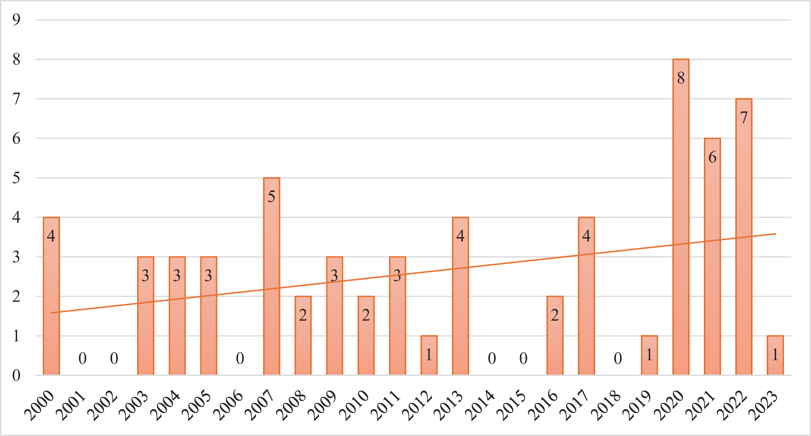
In the past 60 years, serious floods, which are defined as floods resulting in a high water level above 2.9 m, occurred in 1964 (3.4 m), 1998 (2.99 m), 1999 (3.2 m) (Bui and Tuan 2018), 2007 (3.28 m), and 2017 (3.2 m) (Hoi An Centre 2020). Furthermore, the impacts of climate change have increased both the frequency and severity of flooding in recent years. This was particularly evident during the historic flood of late October 2025 (Figure 3), when floodwaters reached approximately 3.4 m, tying the record level achieved during the 1964 flood (Thai Reference Thai2025). The Hoi An Economic Department, which is responsible for coordinating flood prevention, lists 37 floods affecting Hoi An city during 2000–2023, with flooding frequency particularly notable in 2020 (8 floods), 2021 (6 floods), and 2022 (7 floods) (Figure 4).
Inundation of the Hoi An Ancient Town Old Quarter in a historic flood in late October 2025.

Number of floods striking Hoi An city per year from 2000 to 2023.

Recent increases in the number of flood events appear connected to economic development and urbanisation. The town attracts a considerable number of tourists who consider Hoi An a “must-visit” destination in the central coastal region of Vietnam (Phi et al. Reference Phi, Phuong and Huy2024). A knock-on effect of this tourism has been a surge in construction projects. A particularly salient example of such projects is the construction of the Công viên Ấn tượng Hội An (Hoi An Impression Theme Park) on a sand island in the Thu Bon River. This project, which was initiated in 2016, is believed to have impeded the movement of floodwater, increasing the risk of flooding in Hoi An Ancient Town (Hoai Reference Hoai2018). Nguyen Su, former Secretary of the Hoi An Communist Party Committee and former Chairman of the Hoi An City People’s Committee, explained:
“Sandbanks follow their own rules: when their elevation is low, water will flood and overflow. However, if you build a structure that raises the elevation, the river’s flow will change during floods. The water will inevitably flow on both sides of the obstruction, which can significantly impact the people living on either side, leading to erosion” (quoted in Hoai Reference Hoai2018).
An additional emerging concern is the construction of hydroelectric dams in upper Quang Nam province. According to Quang Nam plans, a total of 40 such facilities will be constructed, of which, at the time of writing, 29 have been completed, 6 are under construction (Quoc Viet 2024), and at least 8 are already operational (Nguyen Reference Nguyen2020). These facilities generate power through the controlled release of water from large reservoirs. However, during the rainy season, they may need to release large volumes of water suddenly, which can cause flooding downstream in places such as Hoi An Ancient Town. For example, the 2007 release of water from the A Vuong reservoir at a rate of 2700 m3/s over four consecutive hours resulted in the severe flooding of downstream areas (Nguyen Reference Nguyen2020).
Conceptual Framework
Resilience is a framework for understanding how individuals, communities, and their environments respond to disturbances or adversity, not just by resisting or recovering from them, but also by adapting, transforming, and even thriving through them (Holtorf Reference Holtorf2018; MacKee et al. Reference MacKee, Askland and Askew2014). This concept can be approached from ecological, psychological, or sociocultural perspectives. This case study of Hoi An Ancient Town approached resilience from a sociocultural perspective to elucidate the long process of accepting, adapting to, and integrating adversity into everyday life. This approach acknowledges that resilience is not only concerned with survival, but also meaning, memory, and cultural continuity. Given this background, the Adversity Acceptance as Resilience (Nguyen et al. Reference Nguyen, Mai, Phan and Baker2024) framework was used in this study to explain how Hoi An residents’ experience, interpret, and respond to flooding—not merely as a threat, but as a part of their daily lives that shapes local culture, behaviour, architecture, and community. This theory comprises three key elements: (1) adversity as a lived, accepted, and culturally meaningful experience; (2) adaptation as a creative, community-driven, and intergenerational process; and (3) transformation of challenges into opportunities for cultural continuity.
Sociocultural approaches to resilience have already been used to investigate several aspects of flood management. Flood memory is regarded as a critical basis for building resilience as it represents an active means of social and cultural remembrance and reflects how communities learn to coexist with floods (Bandyopadhyay et al. Reference Bandyopadhyay, Banerjee and Banerjee2024; Garde-Hansen et al. Reference Garde-Hansen, McEwen, Holmes and Jones2017). Garde-Hansen et al. (Reference Garde-Hansen, McEwen, Holmes and Jones2017) showcased the influences of community and shared memories of past floods on the building of resilience as well as the emotional and affective reactions to contemporary flood events. Mcewen and Holmes (Reference Mcewen, Holmes and Freddy2017) argued that flood memory, which is a type of local lay knowledge, should be combined with expert scientific and technical knowledge to realise “learning for resilience”. In terms of community resilience, Chen et al. (Reference Chen, Liu, Lin, Wang, Zhang and Feng2024) investigated how social capital (e.g., cohesion, collective efficacy, sense of belonging, trust and reciprocity, and informal social control) promotes community resilience during flooding. Other studies have evaluated the relationship between social identity and community resilience (Farny and Dentoni Reference Farny and Dentoni2025), the characteristics of communities demonstrating strong social resilience in flood-affected regions (Lwin et al. Reference Lwin, Pal, Shrestha and Warnitchai2020), and the effects of social dimensions on the ability of a community to adapt to flash floods (Hague 2016). Furthermore, the different levels of vulnerability and resilience to flash floods among poor, middle-income, and wealthy households have been investigated (Kamal et al. Reference Kamal, Shamsudduha, Ahmed, Hassan, Islam, Kelman and Fordham2018), and the influence of local hazard mitigation plan quality on disaster risk reduction has been assessed considering its link with community resilience (Kim and Marcouiller Reference Kim and Marcouiller2018).
These responses to flooding are grounded in the understanding that humans and their environment function as interdependent components within a larger system (Walker and Salt Reference Walker and Salt2012). Indeed, considering the relationship between people and nature as a dynamic and reciprocal interaction is essential for understanding how communities have perceived, adapted to, and been shaped by environmental changes over time (Leary Reference Leary2009). In early civilisations, nature was closely associated with mythical deities and regarded with reverence. By the 17th century, landscape art signalled a growing cultural interest in the beauty of natural scenery (Jigyasu and Jokilehto Reference Jigyasu, Jokilehto, Rouhani and Romão2023). Jigyasu and Jokilehto (2024) argued that close interactions between communities and their environment have shaped cultural traditions and contributed to the development of knowledge for managing opportunities and constraints. Thus, people living in areas prone to frequent natural hazards, such as floods, have developed multi-layered disaster-related knowledge through continuous engagement with their surroundings. For example, people in the Tsholotsho district of Zimbabwe use indigenous knowledge-based signals such as dark clouds and rain-making birds to anticipate heavy rains and the sprouting of new tree leaves to mark the beginning of the rainy season. Reading these signals allows locals to devise and implement appropriate measures for managing flood risk, including designating land zones, moving livestock shelters to elevated areas, and utilising locally available resources (Ernest and Munsaka Reference Dube and Munsaka2018). Similarly, communities in the Chitral district of Pakistan rely on traditional warning systems, such as fire signalling at nighttime and gunfire during the day, to alert nearby residents of impending dangers, including flash floods (Dekens Reference Dekens, Shaw, Uy and Baumwoll2008). In terms of housing, residents in Jakarta (Indonesia) mitigate the dangers of flooding by constructing ditches to divert floodwaters away from homes, building terraced houses, and elevating housing levels (Iqbal et al. Reference Iqbal, Nazir and Awan2025). Overall, diverse communities from different countries have used combinations of indigenous knowledge, warning systems, and adaptive housing design to cope with flood risks.
In recent decades, numerous nations have increasingly relied on river-engineering approaches, such as continuous embankments, levees, channelisation, flood control dams, and drainage pump stations, to reduce flood damage (Liao Reference Liao2012, Liao et al. Reference Liao, Le and Van Nguyen2016). These responses to flooding are clearly grounded in the notion of controlling nature rather than recognising the human being as an integral part of it (Asad et al. Reference Asad, Ahmed, Vaughan and von Meding2022). Although engineered approaches can effectively manage floods within their intended design limits, they can also heighten the risk of severe flood damage when water levels surpass the design capacity and cause failures (Itsukushima et al. 2012). Some Filipino communities, for example, have blamed the greater frequency and severity of flash floods on the construction of hydropower dams upstream (Heijmans Reference Heijmans2001). Several non-structural measures have been implemented in response to the challenges introduced by flood control infrastructure, including warning systems, insurance schemes, and land-use regulations; however, these measures play only a marginal role in overall flood management (Parker Reference Parker2000).
The residents of rural communities in Bangladesh, Cambodia, India, and Vietnam still practise forms of living with floods. Bangladeshis residing in the floodplain consider normal floods as beneficial and have periodically adapted to them because both agriculture and fisheries depend on the natural flood cycle. Residents in the Tonle Sap area of Cambodia seasonally relocate to higher ground and construct their houses on stilts approximately 5–6 m above the ground (Berkes Reference Berkes2007). Dwellings in Majuli Island (India) are also built on high stilts, with large front roofs oriented toward the village road; many follow a linear design that can accommodate multiple families (Khalif et al. 2023). Finally, living with floods has been strongly embedded in the lifestyles of residents in the Mekong River Delta of Vietnam, where the flood season is viewed as “income season”. Locals here also live in traditional stilt houses and maintain their mobility using boats and footbridges (Liao et al. Reference Liao, Le and Van Nguyen2016).
Research Methods
This study employed a qualitative case study approach within an interpretivist paradigm underpinned by a constructivist epistemology (Schwandt Reference Schwandt, Denzin and Lincoln1998). The interpretivist paradigm assumes that reality is best understood through the meanings and perspectives of those who experience it, and the use of a constructivist epistemology in this context recognises that knowledge regarding flooding and resilience is co-constructed through the interactions between the researcher and research participants. Note that this study forms part of a broader investigation into the resilience of World Heritage Sites in the context of climate change and increasing flood risks across the Asia-Pacific region. The study design focused on gathering empirical data through field observations, document analysis, and semi-structured interviews. Ethical approval for the study was granted by the Griffith University Human Research Ethics Committee (GU Ref No: 2023/366), and the research was classified as low risk. Data collection occurred between March 2023 and September 2024.
An initial field trip was undertaken in March 2023 to gather insights into the study context of Hoi An Ancient Town, review records of previous floods, and establish rapport with local researchers, heritage managers, cultural managers, officials, residents, and other stakeholders. A field diary and photographs were used to document observations and conversations during this trip. The collected materials helped shape questions for subsequent in-depth interviews and supplemented the documentation and interview data gathered through fieldwork. The document review evaluated multiple reports related to flood management and prevention in Hoi An during 2002–2024; these reports were provided by the Hoi An Centre for Cultural Heritage Management and Preservation (hereafter Hoi An Centre) and Hoi An Department of Economics.
During the subsequent fieldwork, 45 semi-structured interviews were conducted with various stakeholders to understand their perspectives on flooding. Interviewees were asked how they assess the likelihood of flooding, how they have adapted to flooding and coexist with it, and what benefits or advantages they associate with cohabiting with flooding. The interviewees comprised representatives of local authorities, heritage experts, cultural officers, heritage managers, business representatives, residents, and visitors aged from their late 20s to 80s with varying degrees of attachment to Hoi An Ancient Town. All interviewees met the criterion for selection, which was that they must be “knowledgeable about the issues being researched and able and willing to communicate about them” (Kumar et al. Reference Kumar, Stern and Anderson1993: 1634). Interestingly, participants older than 60 years old tended to compare past flooding (before 1975) and current flooding through reference to their personal memories.
Interviews were conducted with six officials from local authorities chosen based on the administrative levels in Vietnam, including the Hoi An city (district) and ward levels. These interviewees were either current or retired officials with significant authority over the direction and management of flood responses in Hoi An. Additional interviews were conducted with three experts who have been living in, working in, or studying Hoi An heritage properties for many years. As defined by Bogner, Littig, and Menz (Reference Bogner, Littig and Menz2009), these experts were individuals with specialist-level knowledge of the research topic. Furthermore, interviews were undertaken with 12 heritage managers who have been working in different departments of the Hoi An Centre, such as Property Management, Old Quarter Management, Exhibition, and the Board of Directors. The Hoi An Centre was established in 2011 (formerly the Management Board of Monuments and Tourism Services of Hoi An, 1992) and is responsible for managing, conserving, and promoting the value of Hoi An Ancient Town. Interviews were also conducted with three cultural officers from the Hoi An Department of Culture and Information, which facilitates the management of cultural, social, and economic activities (including tourism) within Hoi An, and two local business representatives from the Hoi An Public Works Joint Stock Company, which manages trees and waste in the city. Another set of interviews was undertaken with 16 residents of different streets in Hoi An, including Bach Dang, Nguyen Thai Hoc, Nguyen Thi Minh Khai, Tran Phu, Hoang Van Thu, and Le Loi, that are exposed to varying degrees of flooding risk and impacts broadly corresponding to their elevation above sea level. Finally, three interviews were conducted with visitors to Hoi An, two from Vietnam and one from the United States of America. The interviews took place in various settings, including the offices of officials and heritage managers, homes of experts and former officials, and cafés.
All discussions and interviews were either tape-recorded or documented through notes. Research participants were assigned pseudonyms to protect their privacy. Nearly all interviews (44 out of 45) were conducted in Vietnamese, the mother tongue of the author; the remaining interview (with the American tourist) was conducted in English. Data were analysed using an inductive thematic analysis approach in which interview transcripts were imported into Microsoft Excel for systematic coding, then initial codes were derived from recurring patterns and meanings in the data to group the contents into broader thematic categories. Three key themes emerged from this analysis: (1) understanding, recognition, and acceptance of floods; (2) adaptation to the adversity of flooding; and (3) flooding as a catalyst for cultural progress. These themes represent the participants’ interpretations of flooding events and their relationships to heritage property, governance, and everyday practices. In addition, data sources, including interview transcripts, official documents, archival records, and observational notes, were triangulated to enhance the credibility and dependability of the findings.
Research Findings
Understanding, recognition, and acceptance of floods
Residents of Hoi An Ancient Town have developed their own knowledge and understanding to anticipate potential floods by relying on natural indicators, including the behaviours of plants and animals. Floods can be forecast by observing wind, rain, clouds, and rainbows, as well as bamboo plants and reeds, highlighting the importance of residents’ close relationships with their natural environment for generating flood management knowledge. For example, Long (male, aged 65), a heritage expert who has studied Hoi An for approximately 30 years, explained that the direction of bamboo shoot growth is linked to the possibility of flooding: “If the bamboo shoots grow in the middle of the bamboo clump, there is the chance of a major flood. If the bamboo shoots grow on the outside, there will be no flood, or only a small flood”. Similarly, Ba (male, aged 69), a former official who worked for the Hoi An City People’s Committee and Hoi An Communist Party Committee, commented: “There could be more heavy downpours this year [2023], but flooding will be minor since the bamboo shoots are growing outward from their mother plants.” This prediction was borne out in the subsequent 2023 flood season, when some streets in Hoi An Ancient Town were flooded with a half of meter of water for a few days, which is considered a “minor flood” in the town (Dac Reference Dac2023). In addition, expert Long explained that reeds can be used to predict when flood waters will recede: “if these plants blossom in the rivers, it indicates that there will no longer be floods.” He also linked his knowledge of flood prediction to traditional proverbs related to preparations for flooding:
“Đóng m $\acute{\hat{\mathrm{o}}}$ng Cu Đê lo v
 $\grave{\hat{\mathrm{e}}}$ dọn gác
Đóng m $\acute{\hat{\mathrm{o}}}$ng Cửa Đại ở lại làm ăn”
[When a rainbow forms over Cu De, prepare to clear the house’s mezzanine.
When a rainbow forms over Cua Dai, stay and work.]
“M $\acute{\hat{\mathrm{o}}}$ng dài thì lụt, m
 $\acute{\hat{\mathrm{o}}}$ng cụt thì mưa”
[A long rainbow means flooding, a short rainbow means rain.]
Many residents believe that heavy rains and floods can be predicted by observing the presence and movements of animals, such as birds and ants. Official Ba shared his knowledge of the movements of wild birds around Hoi An Ancient Town: “When a flock of birds flies from Cham Island to the mainland, I know for sure that in a few days there will be wind and rain. When it is raining and a flock of birds flies from the mainland to Cham Island and the sea, I know for sure that the weather will clear up and become calm”. Similarly, Phan (male, aged 76), a resident, explained how he forecasts the level of floodwater by observing ants moving from lower to higher ground: “When ants start carrying their eggs and food from the ground to higher places in my house, it indicates a potential flood. The higher the ants relocate, the higher the floodwater is likely to be”. The importance of plants and animals in forecasting weather has been highlighted by Jigyasu and Jokilehto (2024), who described how traditional cultures believe in the concept of anima loci, which considers nature to be a living entity with a soul. Under this concept, both animals and plants are conscious of their surroundings and possess intelligence. In the case of Hoi An Ancient Town, this notion underpins the relationship between humans and more-than-humans in flood management. Indeed, the extensive experience among Hoi An residents of enduring flooding (Nguyen et al. Reference Nguyen, Mai, Phan and Baker2024) has created and sustained inter-generational knowledge of flooding based on the relationship between people and the natural environment. Crucially, a kind of “flooding formula” frequently shared by many elderly Hoi An residents suggests that flooding is likely to occur when certain indicators are present, including heavy rains for several days, strong winds from the sea (particularly the gió chướng, the northeast monsoon wind), and high tides during the rainy season. Such natural conditions typically prevent river water from flowing into the sea, which causes flooding in Hoi An. However, as these traditional indicators have been affected by hydropower dam construction and ongoing climate change, technologies including meteorological observation and forecasting methods, broadcast systems, and social media platforms have become increasingly critical for coping with flooding.
The use of meteorological technologies for weather forecasting and data capture was described by local official Minh (male, aged 49): “The forecast and warning of flooding have been more modern, thereby improving accuracy for flood management”. Broadcast systems have also played a vital role in providing residents with weather updates through television and radio announcements. Furthermore, social media platforms, such as Facebook and the Vietnamese app Zalo, have been widely utilised to disseminate rainfall information and flood warnings. The three officials Ba, Minh, and Nhan (male, aged 43) explained that a Zalo chat group comprising people from different agencies and organisations in Hoi An is established by the Hoi An Committee for National Disaster Prevention and Control Search and Rescue prior to the rainy season and subsequently used to “coordinate efforts to prevent floods in the town”. Thus, according to official Nhan, Zalo plays a vital role in “maintaining an organised and quick flow of information and reducing misinformation during floods”.
Residents also manage floods by leveraging the communication and social networking features of the Facebook and Zalo apps to share information, coordinate responses, and offer support. The Facebook page Thời tiết Hội An (Hoi An weather) provides access to the latest weather updates, including expected amounts of rainfall and flood warnings, and serves as a platform for residents to share videos and stories about flood prevention. A local shop owner Dao (female, aged 44), who lives on Hoang Van Thu Street, reported: “It is so convenient for me to use Facebook to access the latest information and official notifications about floods. Therefore, I can plan to cope with the floods by moving items in my shop upstairs if necessary.”
Adaptation to the adversity of flooding
The layout and architecture of Hoi An Ancient Town are heavily influenced by adaptations to flooding. Many local houses have been constructed in favourable locations where they are protected from strong wind and seawater: “Houses are not affected by strongly flowing water”, stated expert Long. Furthermore, the staggered placement of houses arranged into closely clustered groups instead of along straight lines reduces the impact of storms and floodwaters. Similarly, numerous kiệt (small and narrow alleys) ranging from 0.7 m to 2 m wide connect different streets throughout the town; these alleys become drainage pathways during floods, channelling water swiftly into the river.
Features of the local housing stock in Hoi An include courtyards, mezzanines in single-story houses, ô thông sàn (inter-floor areas) in two-story houses, giếng trời (open spaces), sturdy wooden frames, thick walls, and tile roofs (Nguyen et al. Reference Nguyen, Mai, Phan and Baker2024). Notably, windows are not equipped with grilles to facilitate evacuation during floods, as was highlighted by Dang (male, aged 46), a heritage manager who once assisted in rescuing a person trapped by flooding in a house at 33rd Nguyen Thai Hoc Street: “Once we entered the house, we could not exit via the main entrance owing to rising floodwaters. We luckily escaped through the house window”. Hoi An residents have also demonstrated their creativity in flood preparedness and mitigation through the arrangement of household items and construction of mezzanines. Families who do not have mezzanines often create temporary storage by placing wooden planks across beams, as recounted by Yen (female, aged 75), a local: “This loft is used as temporary storage for belongings, and my family can either take refuge there or evacuate elsewhere”. Similarly, housing pillars rest on stone foundations, and power outlets are located above previous flood levels to prevent damage in the case of flooding (Figure 5).
Housing pillars placed on top of stone foundations and power outlets located above previous flood marks in houses along Bach Dang Street, the lowest-lying street in Hoi An Ancient Town.

Adaptation is also manifested in the comprehensive measures taken each year to prepare for flooding. These measures require communal effort involving multiple stakeholders, including local authorities, cultural and heritage management departments, and residents. Locals often set aside their regular work to concentrate on flooding preparation and prevention around late Lunar August. This is also an opportunity for family reunions, as members gather to socialise and make pancakes or Quảng noodles from local ingredients, such as prawns, crabs, and fish. Expert Bao (male, aged 66) commented: “The flooding season can be challenging but also joyful for local people because it is time for family gatherings, food cooking, and doing whatever we enjoy”. Meanwhile, cultural departments typically refrain from organising large-scale promotional events for visitors during the rainy season to focus their attention on flood mitigation and prevention.
The Hoi An Centre is responsible for protecting all Hoi An Ancient Town properties, and it collaborates with other departments in Hoi An city as well as local authorities to ensure the effective management of heritage properties. Flood management efforts commence at the beginning of each year, well before the rainy season, to ensure proper preparation and coordination (Figure 6). At this time, the Steering Committee for Natural Disaster Prevention and Search and Rescue is strengthened and planning for flooding management is initiated. During April–June, the Hoi An Centre collaborates with officials from Minh An, Cam Pho, and Son Phong wards to assess the condition of traditional buildings. After identifying the extent of degradation, phases of restoration are carried out to reinforce any degraded structures. These measures are completed well before the rainy season begins. In addition, evacuation planning allows residents to organise their own evacuation or participate in collective evacuations. In the latter case, residents from affected areas are instructed to relocate to designated schools: the evacuation plan for 2023 designated 9 schools as evacuation centres for residents from different districts within the Old Town, providing a total capacity of 4000 people. As official Ba explained, people must be evacuated to multiple locations because “if an incident occurs, it could be catastrophic for many people”. People also normally stay on the second floor at each school to avoid unexpected floodwater.
Annual flooding management plan for the Old Quarter of Hoi An Ancient Town, created by the Steering Committee for Natural Disaster Prevention and Search and Rescue.

Once flooding occurs, people in Hoi An join efforts to cope with the flood waters and their aftermath in a calm and orderly manner. In houses, bulky appliances, such as refrigerators and freezers, are moved to the upper floor and kept there throughout the flooding season, whereas smaller appliances, such as fans and cooking utensils, are only relocated when floodwaters rise. In some cases, metal scaffolds are erected to store residents’ belongings. When severe flooding occurs, residents follow the prearranged evacuation plan. Those who want to undertake their own evacuation might seek support through social media platforms, such as Facebook or Zalo. For example, many hotels and homestays post “storm status” updates on social media to aid those in need of shelter during floods (Tran Reference Tran2019). Regarding tourism, Hoi An Ancient Town has stopped receiving visitors during active flooding. Hai (male, aged 47), a cultural manager from the Centre for Culture, Sports, Radio, and Television in Hoi An expounded: “If there is a storm or rising floodwater, all guided tours are suspended to prioritise storm and flood prevention measures”. Any visitors who are already in Hoi An are given information and advice about safe and unsafe areas through their accommodation providers, with updates coordinated by the Hoi An Department of Culture and Information and Hoi An Police Department. Furthermore, certain tourism routes may be closed under the supervision of the police during flood days to ensure the safety of visitors.
When floodwaters recede, whether during the day or night, residents use the remaining water to clean their houses, as removing dried mud is more challenging. Shop owner My (female, aged 45) shared her experience of handling mud after floods: “After each flood, when the water recedes, it leaves thick mud everywhere. My elders advised that it must be cleaned within the first one or two days; otherwise, once the mud dries, it becomes very difficult to scrape off. After clearing the mud, all the doors should be opened to let in wind and sunlight, which helps the house dry faster and reduces dampness and mould.”
Finally, across Hoi An Ancient Town, residents have become accustomed to utilising flood marks. These marks, which serve as both symbolic reminders of previous floods and indicators of possible flooding scenarios, duplicate the more formal three-level flooding severity scale included in official flood management plans: Level I indicates flooding in Bach Dang Street, Level II indicates flooding in Nguyen Thai Hoc Street, and Level III indicates flooding in Tran Phu Street. Generally, these measures for dealing with and recovering from floods have been inherited from previous generations. Thus, the Hoi An community’s proactive approach to flood management is deeply rooted in transgenerational knowledge derived from their long endurance of flooding.
Flooding as a catalyst for cultural progress
Flooding has been deeply embedded in the local cultural identity of Hoi An, as exemplified by the worship of Bac de Tran Vu (Zhenwu) at Chua Cau (Bridge Temple), which is located on a water channel draining into the Hoai River, where it is prone to annual flooding. Zhenwu worship has been practised here for several centuries, reflecting “a mindset of cohabitation and harmony with floods” (cultural officer Tam, male, aged 57). In the contemporary context, flooding challenges have been turned into tourist experiences. Staffers at popular tourist sites, such as Tan Ky House, Quan Thang House, and Chua Cau, describe how residents prepare for and cope with floods, how local houses are built to survive floods, and the record heights of previous floods. American visitor John (male, aged 35) expressed his admiration: “I am so impressed that the town’s residents adapt and make the best of the situation, maintaining their livelihoods and preserving their own houses”.
Tourists now have the opportunity to experience Hoi An Ancient Town on flooding days, with tours offered in boats traditionally used to transport residents during the rainy season (Figure 7). Furthermore, local coffee shops might generate income by offering tourists the “unique” experience of drinking coffee while soaking their feet in the floodwaters (Minh 2023). Recognising the tourism potential of the floods, an official tour called Hội An mùa nước nổi (Hoi An’s flood season tour) has been approved by the Quang Nam Department of Culture, Sports and Tourism to allow “visitors to experience boating through the old town on days when the water rises, or enjoy rowing on the Thu Bon River (Cam Kim) while hearing stories about the traditional boats of Quang Nam” (Thai 2024).
Visitors travelling on a wooden boat down Nguyen Thai Hoc Street, Hoi An Ancient Town during the 2022 flooding season.

In return, visitors have helped strengthen the resilience of Hoi An Ancient Town by offering support for flood recovery. In years when the town experiences eight or nine floods, repeated clean-ups can be challenging for residents, who are touched when visitors take part in the street clean-up. Cultural manager Hai (male, aged 47) explained that “the cleanup is a joint effort between residents and visitors. It is heartening to see that visitors choose Hoi An as their destination under any conditions or circumstances and join the local people in overcoming the floods”. In addition, visitors can join employees of the Hoi An Public Works Joint Stock Company in removing trash from the Hoai River and clearing mud from the streets. Company representative Khanh (male, aged 53) recounted that “when [tourists] see company workers cleaning up, they join in to help collect trash. When a large amount of trash gathers at the bridge, we must remove it to clear the flow. If too much trash accumulates, it could obstruct the flow and affect the safety of the bridge. Each time a flood happens, foreign tourists join in. Even when cleaning up the mud, they also participate”.
Research Discussion
The results of this study demonstrate that rather than avoiding or retreating from flood threats, Hoi An residents have opted to coexist with floods, accepting and even thriving amid this adversity for many generations. The Adversity Acceptance as Resilience framework challenges dominant narratives claiming that adversity is a threat; instead, it recognises resilience as a dynamic and lived experience embedded in cultural traditions, inter-generational and place-based knowledge, and cultural continuity. By focusing on these attributes, this study provides an excellent example of adversity acceptance as resilience in Hoi An Ancient Town, where residents have learned to predict, respond, and adapt to recurring floods over generations. The study also highlights how floods can serve as a catalyst for cultural sustainability in response to adversity in urban environments such as Hoi An.
The management of flooding among residents of Hoi An reflects a harmonious relationship between humans and nature. Plants, animals, and rivers have been integral parts of life in Hoi An throughout the history of the town, resulting in the inclusion of water-related elements, such as carvings of fish, crabs, and prawns, in many traditional wooden houses. Moreover, several local festivals, including the Fisherman Festival, Whale Worship Festival, and Boat Festival, are deeply intertwined with the river and sea (Tran Reference Tran2020). Despite the “hustle and bustle” context of modern Hoi An, a close relationship with nature remains deeply embedded in everyday life, as highlighted by researcher Tran Van An, former Deputy Director of the Hoi An Centre, who explained: “In many houses, [life] is not just about conducting business. People take time to relax by moon-gazing, tending ornamental plants and fish, raising birds, and bringing nature closer to themselves. This connection with nature cultivates a peaceful disposition. These are refined hobbies, cultural activities that allow people to embrace culture, rather than merely being consumed by business and the pursuit of profit” (Le Reference Le2017).
Thanks to the close bonds between residents and nature, local knowledge of flood management in Hoi An Ancient Town shapes a part of what can be understood as a multifaceted technoenvironment (Padmanabhan Reference Padmanabhan2016). A key element of this technoenvironment is manifested in residents’ reliance on information communicated by the behaviours of plants and animals to understand, predict, and respond to the challenges posed by annual floods, thereby allowing people to live sustainably alongside nature (Agrawal Reference Agrawal1995). These traditions have evolved through a long process of learning from both mistakes and successes, which has enabled the community to balance the different aspects of their environment and manage potential natural hazards (Jigyasu and Jokilehto 2024). Such traditions are rooted in the inter-generational transmission of knowledge through the local architecture and manner in which residents respond to rising floodwaters and their aftermath. For example, people in ancient Hoi An began to record flood levels many centuries ago by marking buildings; in modern Hoi An, these flood marks serve as a reminder to residents to move belongings out of danger in preparation for potential floods and are used by authorities to communicate the meanings of different warning levels. These trans-generational learning experiences empower locals to manage floods confidently and proactively by constructing multi-story buildings, creating temporary lofts to safeguard belongings, and even using floodwater to clean their homes. This is consistent with Dei’s definition of indigenous knowledge as “common sense knowledge and ideas of local peoples about the everyday realities of living” (Dei Reference Dei1993: 105). Therefore, the findings of this research provide a comprehensive view of knowledge regarding acceptance and adaptation to flooding adversity.
Living with floods in Hoi An Ancient Town represents an alternative approach to flood management in an urbanised context. This notion is vividly manifested in the way residents rely on their traditional houses and other available resources to relocate household and business items and in how various stakeholders collaborate and devise flooding management strategies suited to a “river town” or “riverine urban area” (Tran Reference Tran1991). Indeed, residents have been highly proactive in preparing for and responding to recurring floods for many generations, revealing a key feature of sustainable cultural heritage: it can adapt to change through creative transformation and ongoing development (Boccardi Reference Boccardi and Albert2015). By contrast, cultural heritage that lacks adaptability and openness to transformation cannot be considered sufficiently resilient and is unlikely to remain sustainable over the long term as a result (Holtorf Reference Holtorf2018). Hoi An residents’ long endurance of floods has demonstrated their resilience to natural hazards. This is consistent with Jigyasu and Jokilehto’s (2024) finding that risk reduction practices were based on inferences drawn from the surrounding context long before the advent of high-tech early warning systems and disaster risk mitigation strategies or procedures. The responses of Hoi An residents to flooding differ considerably from those of residents in other cities. For example, in Jakarta (Indonesia), where flooding has similarly been a recurring hazard for hundreds of years, minor floods can disrupt traffic and affect the everyday lives of residents living near overflowing sewers, canals, rivers, and coastal areas; various flood mitigation projects have been rapidly implemented in response, spurring debates over suitable residential areas (i.e., avoiding riverbanks), and ambitious proposals such as relocating the entire capital have been advanced to avoid flooding altogether (Hellman Reference Hellman2015). Therefore, this case study of Hoi An Ancient Town contributes to a shift in paradigm from flood-resistant to flood-resilient cities, moving the disaster management focus from “safety against floods” to “safety during floods” (Schielen and Roovers Reference Schielen and Roovers2008). Critically, developing urban resilience to flooding is an adaptive process through which cities learn to coexist with rather than resist regular flooding and construct the capacity to withstand extreme events (Liao Reference Liao2012).
The sustainability of Hoi An culture, which has been partly shaped by generations of living with floods, represents another critical aspect of flood management. Because flooding is a normal part of the local lifestyle, residents have taken advantage of it in many ways, such as by capitalising on its capacity to recharge fertile land. Historical records written by Borri in the early 1600s reveal that residents of the region were able to cultivate up to three crops of rice per year, with floodwaters providing “a stable livelihood without undue effort” (Borri Reference Borri2014: 10). Notably, flooding can also offer pleasant surprises, such as meat from drowned animals carried downstream by the floodwaters, which local people consider “unexpected presents” (Nguyen et al. Reference Nguyen, Mai, Phan and Baker2024). More critically, Hoi An’s centuries-long rich history of trade and cultural exchange with people from different countries, which was enabled by the very rivers that flood the town, contributed to the outstanding universal values for which it is famous today. Indeed, flooding is now considered one of Hoi An’s outstanding unique features, attracting visitors interested in learning about and experiencing it in their own ways. This interest has created fresh opportunities for locals during the rainy season: instead of shutting down operations during floods, many local operators now offer “flood tours” for visitors that generate up to a million dongs per day per person earnings (approximately 25–40 USD) (Ngo Reference Ngo2022). Some visitors also join locals in cleanup efforts after the waters recede. These mutual benefits from tourism reflect the resilience of Hoi An residents and have enhanced the sustainability and richness of Hoi An culture over the years. Finally, floods are more than natural events for the people of Hoi An; they carry social and cultural meanings and provide opportunities for family members to come together, cook, and share meals in a way that strengthens bonds and creates a sense of togetherness. In this manner, floods have become an unexpected opportunity for reunion, where the rhythm of daily life slows, conversations flow, and traditions are passed down across generations. Thus, the experience of flooding reflects the resilience, cooperation, and enduring cultural spirit of the Hoi An community.
Conclusion
This study used the Adversity Acceptance as Resilience analytical framework to describe the experiences of Hoi An Ancient Town residents with floods. These people have been living with floods for centuries; their flooding management knowledge has been gradually shaped and harnessed through their close relationships with the more-than-human environment, which includes rivers and water systems, and is passed down from generation to generation. In this context, flooding has become an integral part of local social and cultural life, architecture, and urban development through the ongoing efforts of residents to accept, live with, and thrive from flooding rather than consider it a purely negative experience. Critically, Hoi An residents proactively prepare for and handle floods annually using flood management practices that extend beyond environmental responses to realise a holistic approach integrating social, economic, and cultural dimensions. This sociocultural approach to resilience reflects residents’ abilities to combine traditional practices with modern measures for protecting the town by incorporating floods into its cultural and economic fabric. As such, this study contributes to the broader literature describing how urban communities, particularly long-established settlements, handle flooding.
Note that this study was subject to several limitations. First, this research was based on a single case study town, although the in-depth focus on Hoi An offers valuable insights contributing to a broader understanding of how individual communities mitigate and adapt to natural disasters in the context of climate change. Second, this research adopted a predominantly sociocultural framework for describing resilience to highlight local practices and community-based adaptation strategies; this perspective could underemphasise other critical dimensions, including technical, economic, and political factors that influence flood management and resilience outcomes in Hoi An. Addressing these dimensions in future research can provide a more holistic understanding of resilience and inform more comprehensive adaptation strategies for heritage cities facing similar challenges. Third, the effects of flooding in Hoi An are increasingly compounded by contemporary pressures such as urbanisation, rising tidal levels, and the construction of hydropower dams in the upstream reaches of river systems. Therefore, future studies should critically examine how these pressures affect existing flood management approaches in the town to generate evidence-based implications for policymakers, heritage managers, and other relevant stakeholders in Hoi An. Finally, flooding occasionally causes significant damage in Hoi An and investigations of the subsequent social disruption among the community should incorporate the voices of vulnerable populations.
As a UNESCO World Heritage site, Hoi An provides a striking example of how local communities can adapt to natural adversities in ways that reinforce their cultural heritage. The resilience of Hoi An provides a model for other heritage sites facing similar environmental challenges, particularly those dealing with the impacts of climate change, such as increasingly severe flooding. The story of Hoi An underscores the potential for cultural resilience to create a sustainable future in which human ingenuity works in harmony with the natural environment to ensure the preservation of culture and community for future generations. Critically, the lessons learned in this study from the experiences of Hoi An residents can provide valuable insights for other cultural sites seeking to navigate the complex intersection of heritage preservation and environmental adaptation.