

INTRODUCTION
The Aegean Sea was well-travelled between the fifteenth and twentieth centuries. A number of diaries, encyclopaedias and travelogues were written during this early modern period, and they document in great detail some of the journeys taken. Furthermore, the names of some of those who travelled are well known to scholars of antiquity – George Wheler (Reference Wheler and Spon1682, with Spon), William Martin Leake (Reference Martin Leake1830 and Reference Martin Leake1835), J. Theodore Bent (Reference Bent1885) – as their diaries are useful sources on the pre-modern topography and ethnography of Greece (Bennet, Davis and Zarinebaf-Shahr Reference Bennet, Davis and Zarinebaf-Shahr2000; Sutton Reference Sutton, Alcock, Cherry and Elsner2001; Wagstaff Reference Wagstaff, Alcock, Cherry and Elsner2001). Some of these early travellers made for Greece seeking out ancient monuments or antiquities, motivated by dreams of a Grand Tour or of classical-mania.Footnote 1 Others, however, merely passed through on more extended travels further east, for pilgrimage, as diplomatic envoys, for trade, or for scientific business.Footnote 2 Yet what all of these travelogues have in common is that they contain a wealth of valuable information on how routes were plotted between coasts and islands: they can be read to tell us about how different places within the Aegean basin were accessed (cf. Bennet and Voutsaki Reference Bennet, Voutsaki, Cherry, Davis and Mantzourane1991; Broodbank, Bennet and Davis Reference Broodbank, Bennet, Davis, Cherry, Scarre and Shennan2004). Many of these travellers moved around by boat, and the routes they chose constitute a well documented matrix of maritime connectivity.
‘Connectivity’ of this sort has been on the agenda of Mediterranean scholars for almost a century now (Braudel Reference Braudel1949;Footnote 3 Horden and Purcell Reference Horden and Purcell2000; and Broodbank Reference Broodbank2013 for the ancient Mediterranean). That regions and micro-regions are linked by the ways people move between them is now well understood, and the importance of mobility and connection in and around the Aegean Sea has now been well treated.Footnote 4 Movement through and experience of a landscape connects both people and places (Tilley Reference Tilley1994; Ingold Reference Ingold2000; Gibson Reference Gibson2007), and the sea provides people with a means of communicating with one another (cf. Broodbank Reference Broodbank2000, 18). Connections are made visible through various datasets, and travel is a good proxy for shedding light on how processes of interconnection change over time.
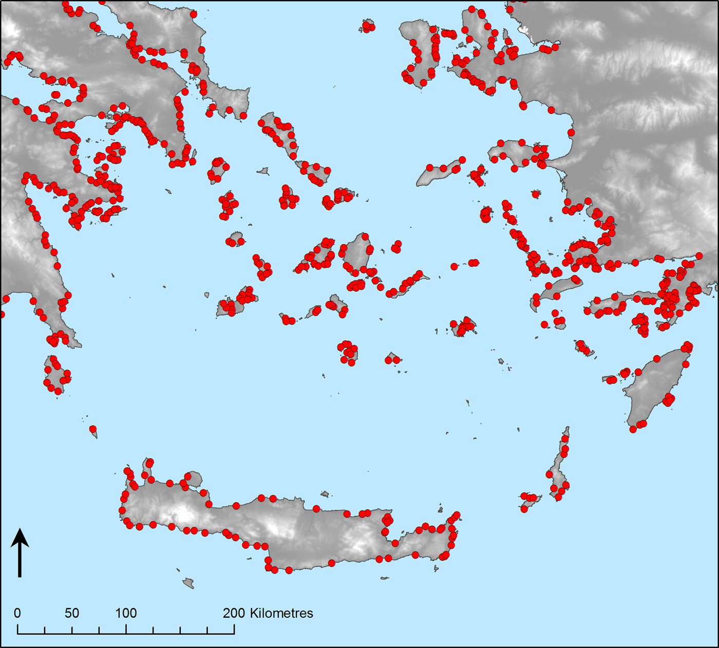
Computational techniques have been used frequently over recent years to investigate issues of connection, route-making, and travel on land-based areas (Bevan Reference Bevan, Dunn and Mahony2013). However, few methodologies pioneered are appropriate for specifically seascape environments. The most common technique employed uses cost-surface modelling (see Lloberea Reference Lloberea and Lock2000; Posluschny Reference Posluschny, Frischer, Crawford and Koller2010; Wilkinson Reference Wilkinson2014; Güimil-Fariña and Parcero-Oubiña Reference Güimil-Fariña and Parcero-Oubiña2015; and Palmisano Reference Palmisano, Kulakoğlu and Barjamovic2017), a system that considers the ‘obstacles’ within a landscape and calculates the path of least resistance between two given points (cf. Conolly and Lake Reference Conolly and Lake2006, 234–62). In a least-cost path (LCP) analysis this renders a single path to connect two known dots, while other techniques can consider a range of possible paths. ‘Obstacles’ are generally considered to be topographic, whereby landscapes are represented by raster images whose grid cells correspond to slope values.Footnote 5 Slopes of a steeper gradient are ‘penalised’ by the model to a greater degree, accounting for the extra effort required in travelling over the slopes of a continuous terrain.Footnote 6 It is clear, then, that some sort of base layer is required, which in most instances can be represented by a digital elevation model (DEM). However, no comparable base layer can be used for analysis of maritime landscapes. The ‘obstacles’ in modelling maritime routes would have to be based on tidal and wind patterns and, given that these systems alter significantly seasonally, daily, and even hourly and in highly localised ways,Footnote 7 no single raster base map can simulate shifting sailing conditions.Footnote 8 Cost-surface analysis could suggest a route between two points under specific types of wind or tide conditions, but it could not suggest (without very complex models) how this route should be adapted in different circumstances. Furthermore, it is inadequate to plot routes only between known ports. On the one hand, the location of harbours relative to rocky coastlines and headwinds, or their distance or visibility from other harbours, made certain places more or less accessible to one another. But on the other hand, it is also important to remember that ships also stopped not infrequently at less formally designated anchorages and stop-over points (Fig. 1), either by choice or by necessity: route modelling must consider that an actual destination is not always the same as an intended destination. For investigating issues of mobility and connectivity in specifically maritime spaces, therefore, environmental-based modelling is not that helpful. One cannot start from the landscape itself; one must, instead, work from other datasets.
The location of c.1200 potential anchorages around the Aegean basin, based on modern sailing charts and nautical maps.

This article presents a different sort of computational technique for engaging with issues of maritime navigability. By performing a statistical analysis on a large corpus of early modern travelogues, the role of seafaring in establishing connectivity will be considered. First, patterns will be identified that elucidate the main navigable ‘corridors’ of the Aegean Sea. Second, the routes taken by travellers will be compared to other historical networks (e.g. cultural, economic and political networks), and it will be discussed to what extent travellers relied on these other routes in charting their own voyages.
TRAVELLERS AND THEIR ITINERARIES
The dataset for this study comprises items that are available for consultation in the library and rare books store of the British School at Athens. Forty-one volumes were consulted, one of which (Yerasimos, Reference Yerasimos1991) collated, for the purpose of a similar quantitative analysis, a number of travel sources.Footnote 9 Furthermore, additional information on sources was obtained from the Aikaterini Laskardis Foundation web resource Travelogues.Footnote 10 The authors cited are referred to as ‘travellers’ and their works as ‘travelogues’, but, as discussed below, some ‘travellers’ did so from the comfort of their armchairs, and some of the ‘travelogues’ are more encyclopaedia than diary.
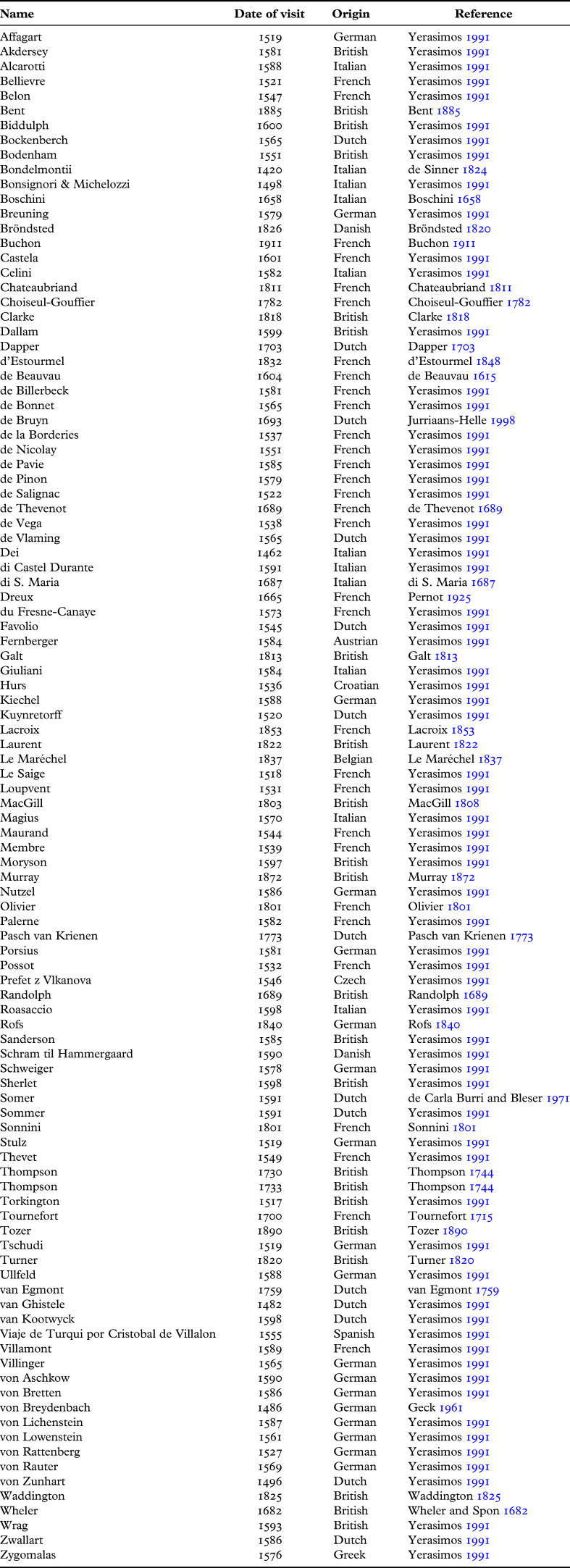
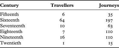
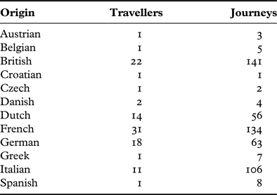
The journeys of 104 travellers are studied here (Table 1). The list is non-exhaustive,Footnote 11 but is representative of some of the material available for study at the BSA. Travels conducted between the fifteenth and twentieth century were analysed (Table 2a), and the largest number of datapoints (n = 65) comes from the sixteenth century: this is, largely, a result of mining from Yerasimos (Reference Yerasimos1991). Travellers were of 12 different nationalities (Table 2b), but Austrian, Belgian, Croatian, Czech, Greek, and Spanish travellers were each represented by only one text each. The most frequently represented nationalities in this study were French (31 texts) and British (22 texts).
Travellers’ texts consulted in this study.

Number of travellers and journeys by century.

Number of travellers and journeys by place of origin of the traveller.

Travel texts were usually written in the first-person, as the works of scholars, scientists and adventures who aimed both to inform and to entertain. Although these travellers must have relied on the local knowledge of captains, sailors or navigators in plotting their routes, paradoxically, these ‘locals’ seldom feature in the texts.Footnote 12 Indeed, when travellers drew on additional sources to supplement their observations they frequently turned to ancient sources – the sort which were the preserve of an elite learned class at this time. For some travellers, interaction with contemporary people was largely through observational ethnography. The consequence of this is that the following analysis does not yield patterns about travel and mobility per se, but about elite and western travel and mobility that was possible to male travellers of a certain class.
The focus of this study is on journeys that were made in the southern Aegean. This relates, primarily, to the islands of the Cyclades and the Dodecanese, and also to the ports of mainland Greece and Turkey. The aim of this study, therefore, is to think about the internal connectivity of the Aegean Sea as a navigable space. For the present analysis, ‘journey’ is defined as a movement of unspecified time without intermediary stops between two places. Journeys made between islands are recorded at the level of the name of the island, rather than of separate ports on the various islands, e.g. ‘Paros to Naxos’. ‘Routes’ are understood as non-fixed entities that comprise many journeys from an initial start-point to an end destination (e.g. ‘Venice to Jerusalem’), and they are, therefore, specific to each traveller. ‘Corridors’, by contrast, are understood as the accumulation of routes by many travellers over time (i.e. areas that encompass commonly taken routes); they are non-physical, but they may have been at certain times illustrated on sea-charts, recorded in texts, or communicated verbally. A ‘network’, moreover, refers to socio-cultural, economic or political systems. This is not to be confused with the network analytical techniques used to explore physical sets of journeys (‘route-networks’), and unless otherwise stated the word ‘network’ by itself refers to human relationships. This juxtaposition is important, however, because one of the key aims of this paper is to put physical and human networks side-by-side. Mapping the data in this way, 530 separate journeys were documented, distributed across 6 centuries and 12 nationalities.
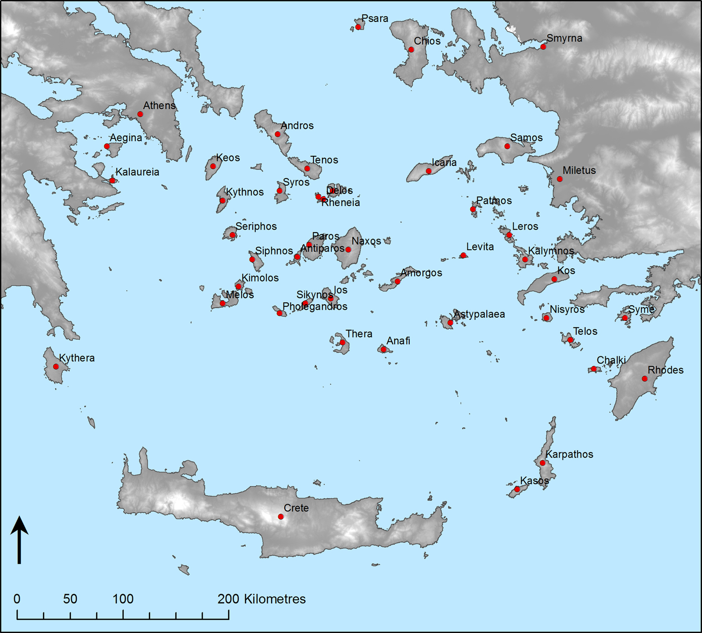
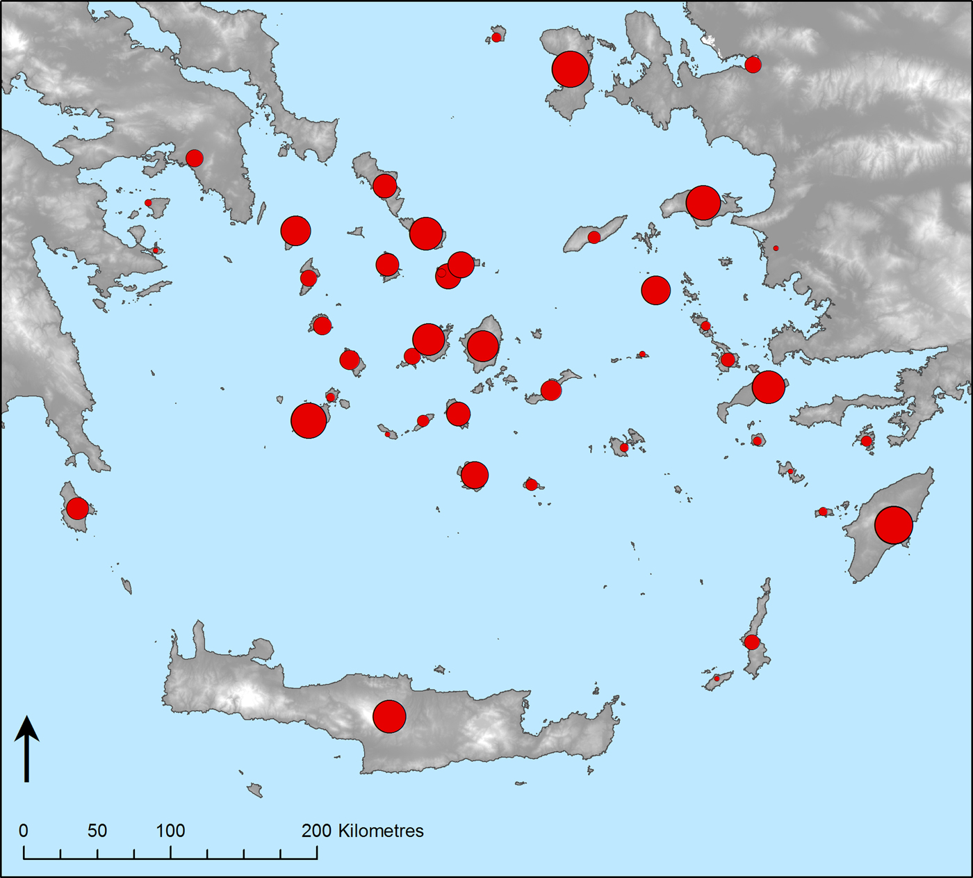
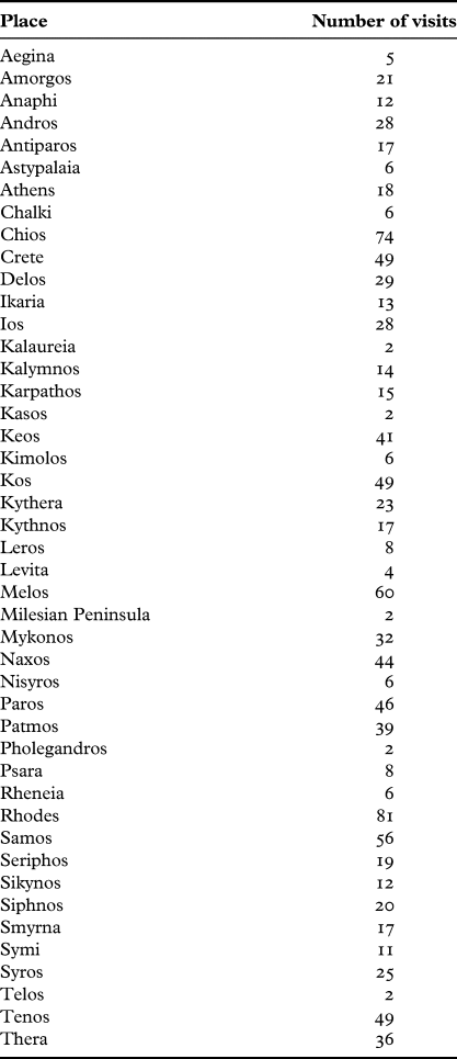
Journeys were made to or from 45 islands or ports (‘places’) in the southern Aegean (Fig. 2). Given that there were 530 journeys analysed and that each journey comprises a movement between two places, the aggregate number of times that places were part of journeys is 1060 (Table 3; Fig. 3). Rhodes (81 times), Chios (74), Melos (60) and Samos (56) were the most frequently visited places, while Kalaureia, Kasos, the Milesian Peninsula, Pholegandros and Telos were only recorded as being visited twice each.
Extent of the study area, and places mentioned within the text.

Map showing the frequency of place mentions in the dataset, where size of point is proportional to the number of times each place was visited (cf. Table 3).

Number of visits received by each place.

What becomes clear from sorting the data is that there is (rather predictably) little obvious relationship between location of a site and its frequency visited. One must consider, instead, the network of routes between places, rather than just the places themselves. Therefore, in the rest of this paper the data is considered by means of network analytical methodologies – a set of techniques now well-known to scholars in the social sciences and the humanities that explicitly handle connections between datapoints.
SCALE AND METHODOLOGY: A REDUCTIONIST APPROACH?
Analysing the data at this scale might mask some of the more subtle patterns in the travelogue corpus – but this is not an issue if the focus, as here, is on broad-scale patterning. The present methodology takes for granted, to some extent, that travellers planned their journeys and that they could go wherever they chose. Yet it has already been discussed that strong, shifting, and unpredictable wind and tide patterns made planning journeys practically difficult.Footnote 13 By sailing in vessels of particular size and propulsion,Footnote 14 one might aim to reduce some of the problems facedFootnote 15 – but the charting of routes was still subject to all sorts of uncertainties.Footnote 16 Clearly, journeys made were not always the journeys intended, and the present dataset is actually a dataset of routes that were merely possible given the particular circumstances of each voyage. However, both the timespan and geographic region investigated are large enough that, even though there will undoubtedly be variations and fluctuations in certain places or texts and at certain times, any ‘bumpiness’ created by anomalies is smoothed over to give a good impression of the main route corridors.
Furthermore, working at a broad scale does not replace close reading, but it changes our engagement with the source material. Over recent years – and owing to the accessibility both of datasets and of computer packages capable of synthesising and transforming larger and more complex datasets – the number of data-intensive studies conducted has risen almost exponentially in the hard sciences, in social sciences and (to a lesser extent) in the humanities (Kaplan Reference Kaplan2015; Richterich Reference Richterich2018, 1–12). Moreover, techniques have been developed to identify patterns above the ‘messiness’ or ‘background noise’ necessarily created in synthesising datasets of such magnitude (Gattiglia Reference Gattiglia2015, 2–3). What these studies have illustrated well is that large sets of archival data reveal patterns and continuities that are not identifiable when texts are read in isolation (Cooper and Green Reference Cooper and Green2015; McCoy Reference McCoy2017). They help to refocus our attention to broader issues that might not be so immediately obvious – such as the themes of connectivity and navigability discussed above. A secondary aim of this paper, therefore, is methodological, and it seeks to explore how data-intensive methodologies can be used productively on the target dataset. Patterns will be evaluated in light of the quality of the data, and the results of the analysis will be used as a starting point for a larger discussion on mobility and connectivity.
A COMPUTATIONAL-BASED METHODOLOGY FOR IDENTIFYING ROUTES AND NETWORKS
The data described above are processed by means of a Social Network Analysis (SNA), using computational tools. The general principles of SNA (cf. Hanneman and Riddle Reference Hanneman and Riddle2005) are now familiar to many historians of Greek history and prehistory (Malkin, Constantakopoulou and Panagopoulou Reference Malkin, Constantakopoulou and Panagopoulou2009; Taylor and Vlassopoulos Reference Taylor and Vlassopoulos2015; Sweetman Reference Sweetman2017), and the application of SNA via digital techniques has been discussed extensively, principally by Tom Brughmans and others (see Brughmans Reference Brughmans2010; Reference Brughmans2012; Collar et al. Reference Collar, Coward, Brughmans and Mills2015; Brughmans, Collar and Coward (Reference Brughmans, Collar and Coward2016); Leidwanger and Knappett Reference Leidwanger and Knappett2018). In an SNA, people, places or things are represented as abstract nodes, and explicit emphasis is put on the connections – or edges – that exist between them. Through the use of various algorithms and statistical tests, one can readily compare the structure of networks, the arrangement of sub-groups within networks, or the most efficient paths between a set of nodes.Footnote 17
A combination of SNA and routes analysis has at its core the principle of Proximal Point Analysis (PPA). In PPA, places are inherently ‘connected’ to others by virtue of geographic proximity, wherein the overall connective potential of a place is proportional to the number of its immediate neighbours and their own connections. It follows, therefore, that places central to larger geographic regions will exhibit higher ‘natural’ levels of connectivity. This principle was first discussed in relation to the Aegean basin (albeit less formally) by Jack Davis (Reference Davis and Betancourt1982), who argued that the island of Delos became progressively more important between 1900 and 700 bc as the ‘Aegean’ region grew and became subject to a greater number of connections. Cyprian Broodbank (Reference Broodbank2000) developed this idea for the prehistoric Cyclades more broadly, arguing that the flow of information and resources depended both on the islands’ proximity to one another, but also on an island's indirect interactions with its neighbours’ own contacts. Most recently, Carl Knappett, Tim Evans and Ray Rivers (Reference Knappett, Evans and Rivers2008), through the creation of their Ariadne model, suggested that interactions between Aegean sites in the Bronze Age were subject both to the geographic proximity, but also to a (shifting) ‘centre of gravity’. It is clear, though, that modelling environmental factors only gets one so far. Route-making and path-finding are not purely environmentally determined, but they are subject to human agency, and to social, cultural, economic and political factors. PPA is insufficient on its own for identifying the route networks under investigation here, and it must be used in combination with the travellers’ texts.Footnote 18
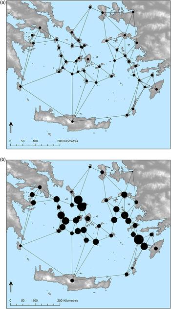
Each of the places identified was visualised as an abstract node in geographic space. For the mainlands, nodes were placed on the approximate locations of known ports; for islands, nodes were placed at a central position. Using the native ‘Generate Near Table’ tool in ArcGIS, the three nearest neighbours of each node were identified,Footnote 19 and edges were drawn between these neighbour sites in order to produce a PPA network (Fig. 4a). In order to assess the potential connectivity of each place (i.e. to test the principles of geographic proximity as discussed above), statistics for the betweenness of each node were generated via the native tools available in Gephi 0.9.2. Betweenness is a measure of the level of connectedness expressed by a node between other neighbouring nodes, and it provides a useful means of measuring how ‘central’ a node might be. Visualised graphically where the size of a node is proportional to its betweenness score (Fig. 4b),Footnote 20 the results demonstrate, rather predictably, that central places like Naxos and Paros, Seriphos and Siphnos, and Kalymnos and Leros have high PPA potential. Places on the ‘periphery’ of this zone (such as Andros, Crete, Kythera, and Psara) do not.Footnote 21 However, one must remember that while the Cyclades were a closed system, they were also connected at various places to external sailing networks. PPA gives some indication of the shape of this closed system, but, depending on where the boundaries of study are drawn, the ways in and out of external networks are harder to identify.
a) Results of the PPA, connecting each node to three nearest neighbours. b) PPA with the size of each point proportional to the betweenness centrality value of the node.

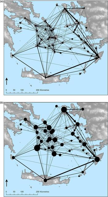
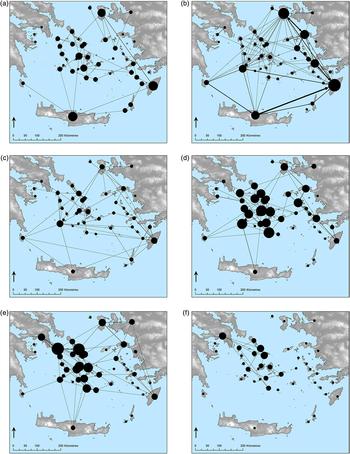
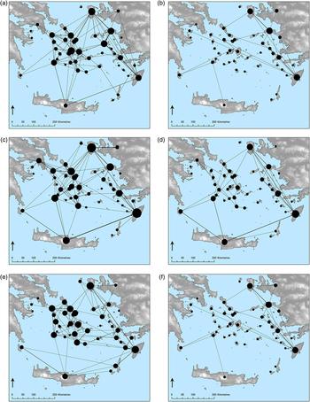
Each of the journeys identified was visualised as a directed edge between two place nodes. These edges were weighted such that journeys made more frequently in the travelogue record were ‘heavier’.Footnote 22 The result, however, is somewhat difficult to interpret visually (Fig. 5a), and one can run additional tests to clarify the patterning. A betweenness measure of each node was once more taken (Fig. 5b):Footnote 23 the results were different in this iteration, given that the betweenness calculation takes account of the weight and directionality of edges, and that these are necessarily different to those generated in the PPA. Maps were produced breaking down the data according to century (Fig. 6) and to the place of origin of the traveller (Fig. 7).
a) Results of the SNA, where each directed edge is weighted to the number of journeys taken between each place node. b) SNA with the size of each point proportional to the betweenness centrality value of the node.

Results of the SNA split up according to century: a) fifteenth; b) sixteenth; c) seventeenth; d) eighteenth; e) nineteenth; f) twentieth.

Results of the SNA split up according to the place of origin of the traveller: a) British; b) Dutch; c) French; d) German; e) Italian; f) Other.

On comparing the overall output with the PPA betweenness network (cf. Fig. 4b and Fig. 5b), some patterns are obvious: places like Chios, Melos and Thera were more popular than an environmentally deterministic model alone would suggest (the reasons for this are discussed more fully below), while the islands of the Dodecanese were visited far less frequently. The point here is a completely obvious one: routes were not plotted for geographic convenience alone; context mattered. Whether cultural, economic, political or social, various factors dictated why some places became more popular stopover points than others. The network model can only identify as much, and it remains to explain the reasons behind this patterning.
ROUTES AND NETWORKS, CONNECTIVITY AND MOBILITY
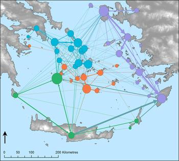
The most frequently travelled routes were identified using a neighbourhood cluster analysis. Neighbourhood analysis distinguishes – independent of other factors such as geographic proximity or betweenness centrality – groups of nodes within a network that are closely associated, based on the number and strength of edges between them (Blondel et al. Reference Blondel, Guillaume, Lambiotte and Lefebvre2008). The native modularity tool of Gephi was used, and four node neighbourhoods were identified. These were arbitrarily colour coded, and the nodes corresponding to each cluster were designated on the above generated betweenness graphic (Fig. 8), i.e. in this model where edges are proxy for journeys between two sites, these are groups of places that were frequently travelled to by means of the same routes. The identification of three node neighbourhood groups indicates there were three main ‘corridors’ of movement around the Aegean Sea. These areas included the southern extreme of the Aegean, the Cyclades, and the Dodecanese and coast of Ionia.
Results of the SNA betweenness centrality calculation, with nodes coloured according to the node neighbourhoods assigned in modularity analysis.

Patterning suggests that the same routes were travelled again and again by different travellers, and two reasons could account for this. First, it is possible that travellers communicated directly their routes to one another, i.e. that route networks were shaped primarily by human networks. As will be discussed below, there is insufficient evidence to conclude this was frequently the case or that human and route networks were directly associated on a broad scale; but there is evidence that some travellers were members of social groups or dining clubs associated with travel and exploration, and it is possible that some travellers (either directly or indirectly) communicated routes to one another through the production of portolan charts and navigation guides. The evidence will be reviewed, but one must also note that such route sharing leaves only indirect and scarce traces of evidence: given the travellers aimed to write with an ‘omniscient’ voice, it was not in their interest to admit that they were following routes already well-trodden. The alternative – and discussed to a far greater extent in this paper – is that travellers relied on the same sources for plotting their routes, i.e. that they had far less agency over route-planning than they might first make out. They might, for example, have been required to travel with ships that were already sailing through the Aegean Sea for some other reason, e.g. with long-distance trade ships, or with certain diplomatic missions. Alternatively, even if they were in possession of their own ship, they might have employed the same local pilots or relied on the same local knowledge; but, as is the problem in the writing of the ‘omniscient traveller’, these local people are almost always written out of accounts. The source material is such that travellers often indicated they had complete choice in where they went, and secondary factors are seldom explicitly identifiable. This paper evaluates both of the possibilities outlined above, and it will suggest that while there is some circumstantial evidence for the first practice (i.e. the sharing of route knowledge between social networks), a more important factor in navigation of the Aegean Sea in the early modern period was the ‘piggy-backing’ of travellers on ships that crossed the area for other reasons.
Route corridors
The route between Kythera, Crete and Rhodes (or onwards to Cyprus) was one frequently taken by pilgrim travellers en route to the Christian Holy Lands, i.e. travellers ‘piggy-backed’ through the Aegean off an existing route network. A not insignificant number of (principally French, German and Italian) travellers in the fifteenth and sixteenth centuries made this journey (cf. Malamut Reference Malamut, Chrysostomides, Dendrinos and Harris2004 and the statistics listed in Yerasimos Reference Yerasimos1991; see also Droulia Reference Droulia, Villain-Gandossi, Busuttli and Adam1980a) and the route was a fairly standard one. Ships would depart from Genoa or Venice for a seven week voyage. After moving down the Italian coast, pilgrims would make for the Ionian islands, and then on to the Venetian fort at Methone. From there, travellers would enter the Aegean basin proper at Kythera, before stopping at Crete and/or Rhodes, occasionally at Cyprus or Alexandria, and then eastwards (van der Vin Reference Vin1980, 13–18). These routes are clear on the data visualisation maps (Fig. 7c, 7d and 7e), and the large size of the nodes for Kythera, Crete and Rhodes indicates that they were places that were passed through frequently by French, German and Italian travellers.Footnote 24 These nodes are also prominent on maps for the fifteenth through to the seventeenth century (Fig. 6a, 6b, and 6c), but the linear route between them no longer existed subsequently (Fig. 6d, 6e and 6f). This is surprising, but a direct route from Kythera to Cyprus used from the seventeenth century onwards would not show up in the data visualisation here.
The strong edges between these site nodes indicate that the exact same routes were often used by different travellers. Here, there is some possibility that route-making relied on the sharing of information between social groups, particularly on the passing down of information for safe and navigable paths. Already by the thirteenth century there were texts in circulation of instruction and advice for taking sea routes to Jerusalem and Constantinople (van der Vin Reference Vin1980, 13–18), and it is possible (although we have no direct evidence) that charts or similar were passed between travellers. These were routes that were well tested, and they could have been taken along navigable currents and weather systems (Williams, Bandindel and Way Reference Williams, Bandinel and Way1867; Duff Reference Duff1893; Lepschy Reference Lepschy1966). Moreover, they were known to be relatively safe from pirates and bandits (cf. Eisner Reference Eisner1990, 40; Utterback Reference Utterback and Taylor2010). More practically, sailing on the same routes allowed travellers to stop at the same places, such as those that regularly expected pilgrims and could offer food and water supplies:Footnote 25 these were places from which travellers could pick up pilots who knew the routes well. These ‘local’ pilots become largely written out of travellers accounts, but they would have been essential for guiding pilgrims and travellers along commonly charted routes. One imagines that in earlier centuries this was by informal arrangement at places like Chios and Rhodes (i.e. the common stop-over points in the Aegean when heading further east), but by the seventeenth century the practice of employing professional pilots was more formalised on Melos (Tournefort Reference Tournefort1715, 117; cf. Murray Reference Murray1872, 318) and then on Syros. It was infrastructure provided by and knowledge of both places and routes, therefore, that entrenched the same series of journeys into routes taken by different sailors in subsequent centuries. As a consequence, these areas are clearly identifiable in the data visualisation, and they were quite evidently principle corridors of movement.
Another of the main route corridors was around the Cyclades: more specifically, there were two separate route clusters around the northern and southern Cyclades. It was not until the eighteenth century that journeys were made in this region in significant quantity (Fig. 6d, 6e and 6f), and, again, the reason for this change relates to how certain social groups travelled at this time. Until the late seventeenth century, the purpose of travelling, as discussed above, was largely to go from point A to point B, and intermediary stops were functional. From the late seventeenth century, however, travellers set out intending to make lots of short stops, and the purpose of travel was more scientific, to explore and meander (Heawood Reference Heawood1912 contra Penrose Reference Penrose1952). To review just a few select examples: George Wheler and Jacob Spon (Reference Wheler and Spon1682) set out with Pausanias and Strabo in hand to guide themselves to places of classical interest; Bernard Randolph (Reference Randolph1689) aimed to document the ‘present state of the islands’, and to offer a near contemporary history of the people who lived there; Michael Fourmont (Reference Fourmont1729) travelled for the purpose of documenting inscriptions; and Richard Pococke (Reference Pococke1743) sought to write an encyclopaedic volume that reviewed works of architecture, geography and mythology that he found on his travels. What is clear is that each of these travellers went into the Aegean basin with a very set mission statement; travel, for them, was not about passing through but about making a thorough assessment of the places visited (Droulia Reference Droulia1980b, 275–7). The edges of the network were not so important at this time, but rather the nodes themselves. As a result, one sees on the data visualisation a dense cluster of journeys that emerges around this time, in part resulting from this desire to travel more leisurely and to explore a greater number of places.
Furthermore, not only were these islands visited by travellers in a similar order, but in encyclopaedias and guidebooks produced during this period too this same sequence of islands was repeated (e.g. Bursian Reference Bursian1872; Miliarakis Reference Miliarakis1874). With very few exceptions,Footnote 26 island groups as written always started with the Ionian islands, then the Sporades, the north Cyclades, the south Cyclades and finally the Dodecanese. Seemingly, the authors of encyclopaedias were mimicking the order in which the islands were usually traversed: travellers either entered at Kythera having passed the Ionian islands (and, in many cases, they would have stuck to the islands on the southern extreme), or they would come via Athens and they made their first stop on one of the northern Cyclades, moving gradually south.Footnote 27 While the ‘grouping’ of islands taxonomically in encyclopaedias is, to some to degree, an entirely arbitrary exercise, this does demonstrate the extent to which the ‘west–east’ view of the Aegean became well entrenched by the eighteenth and nineteenth centuries.
Moving back to the network analysis, the final ‘corridor’ highlighted by the modularity analysis lies to the east of the Aegean, between the coast of Ionia and the Dodecanese islands. These routes appear to have been popular in the fifteenth and sixteenth centuries, and subsequently in the eighteenth century (Fig. 6a, 6b and 6d). Travellers frequently stopped at Rhodes as they did on the way to places of Christian pilgrimage, and, owing to the node's place in both of these networks, the island has a relatively high betweenness score when compared to its neighbours (Fig. 5b). Many of the reasons given above for the popularity of various routes can also be applied to the east Aegean. On the one hand, it was not so much that travellers wanted to stop here as they needed to make stops on longer routes to either Constantinople (Olivier Reference Olivier1801), Egypt (Belon du Mans 1555 [Glardon Reference Glardon1997]; Sonnini Reference Sonnini1801), or the Levant (Tournefort Reference Tournefort1715; Galt Reference Galt1813; Clarke Reference Clarke1818). On the other hand, just as there had been a sudden interest from scholars of the late seventeenth century onwards in the Greek world, British (Turner Reference Turner1820; Burgess Reference Burgess1835) and French (Chenavard Reference Chenavard1849) travellers around the same time and later expressed a certain passion for areas in the east parts of the Aegean (Stoneman Reference Stoneman1987, 130–5; Bernard Reference Bernard1988; Barthélemy Reference Barthélemy1992). The coast of Asia Minor was, as were the islands, both a ‘stopover area’ and a place of learning and exploration: the engagement of travellers with this region varied according to their ideas and preferences at different times.
Social networks and route-making
As discussed above, from the late seventeenth century the reason for travelling became less functional and more to do with exploration. This shift in mentality is not entirely anecdotal, and around this time formal peer networks were created to encourage, finance and publish travel both in the Aegean Sea and beyond. For example, the establishment of the Royal Society in 1660 and the Society of the Dilettanti in 1734 provided a platform for the sponsorship of British travellers:Footnote 28 members were dispatched to far-off lands, and they were encouraged to assemble publications comprising observation, instruction, and anecdotes that could entertain a wider audience.Footnote 29 Across Europe there was a growing appetite for antiquity and for the classical past: the Académie des Sciences was founded in Paris in 1666, and it fulfilled a similar function in providing backing and instruction for a new cohort of scientists and explorers. In two ways, in particular, these new social networks provided impetus for travel, and for travel to specific places, as seen through the example of the Society of the Dilettanti. First, the Society would issue calls for its members to explore, document, and publish on specific places, promising financial sponsorship: membership of the Society (i.e. privileged access to this social network) gave travellers the opportunity to take up these offers. As an example, at a meeting of the society in April 1764, £2000 was promised to a member who could demonstrate they had the qualification to explore Asia Minor. The Society chose Richard Chandler, and he was issued with a list of instructions relating to his point of departure, to his base at Smyrna, to the recording he must undertake, and to financial matters (Cust Reference Cust1898, 84–7). Second, Society members were encouraged to use the opportunity of travel to make contacts they would not normally encounter in England, and so much is noted in a letter from Joseph Spence to his mother Mirabella dated from February 1741.Footnote 30 Furthermore, Spence wrote to or had guidance from 33 contacts he met through the Society of the Dilettanti during his travels (Klima Reference Klima1964 [1747, 1820, summarised in Kelly Reference Kelly2009, 267–9]), exploiting the peer network that membership of the society provided him.Footnote 31 In both of these ways, social networking and travel were very clearly entangled in the early modern period. The creation of societies like these helped to formalise venues at which networking could take place, and this networking had both direct and indirect effects on the route-making undertaken by travellers.
On the other hand, even if peers within a network did not know one another directly, knowledge was inherited and passed on between subsequent generations of scholars and travellers: both copying and reproduction illustrates this concept well. The production of portolan charts in this period goes back at least to the work of the Cristoforo Buondelmonti, a priest from Florence who settled in the early fifteenth century on the island of Rhodes. Buondelmonti travelled at various times around the islands to collect manuscripts and consult documentation (cf. van der Vin Reference Vin1980, 133–5), and in 1420 he sent to Cardinal Giodrano Orsini an encyclopaedic work entitled the Liber Insularum Archipelagi. This volume contained detailed commentary on the situation of the islands, and also maps of the places discussed. The publication of the Liber inspired a new genre of writing at this time (the ‘isolario’), and over subsequent years similar texts were published both by other Italian scholars (Francesco Berlinghieri 1480 [Skelton Reference Skelton1976]; Bartolomeo dalli Sonetti 1485 [Goff Reference Goff1972]) and also by Germans (Henricus Martellus Germanus 1490 [Edson Reference Edson2018]) and French (André Thevet 1584 [Lestringant Reference Lestringant1985]). However, it was not just the genre that was transmitted between authors. In 1528, Benedetto Bordone published an isolario whose text was based very closely on that of Buondelmonti, and whose maps were copied from dalli Sonetti. Similarly, dalli Sonetti's maps were reproduced with few additions or alterations by Antonio Millo in 1590 (Tselikas Reference Tselikas2006), and again by Marco Boschini in 1658; and the map of the Aegean produced by Tomaso Porcacchi (Reference Porcacchi1572) seems to have been based on a similar prototype of another earlier scholar, Sebastian Münster (1540 [McLean Reference McLean2007]) – albeit with the rather whimsical addition of dolphins and various mythical sea creatures. Knowledge of the Aegean and its routes was not only transmitted through the ages, but the very same information was repackaged and reinterpreted in different venues. The consequence of this relates to the more general point made above: that certain outlooks on the Aegean, certain ways in which its islands were grouped together, and certain routes suggested between its various parts became progressively entrenched, and that the exchange of information among peer-groups and cultural networks drove this practice. But, more specifically for this study, the consequence is that certain routes may be somewhat ‘over-represented’: if the same journey or sequence of journeys is repeated between various texts, they will necessarily have been visualised multiple times in the model used.
Economic and political networks
The previous section reviewed the limited and rather uneven evidence for the relationship between human and route networks. It now remains to move the discussion to a much broader scale and consider how macro economic and political networks opened up or closed off certain corridors to early modern travellers.
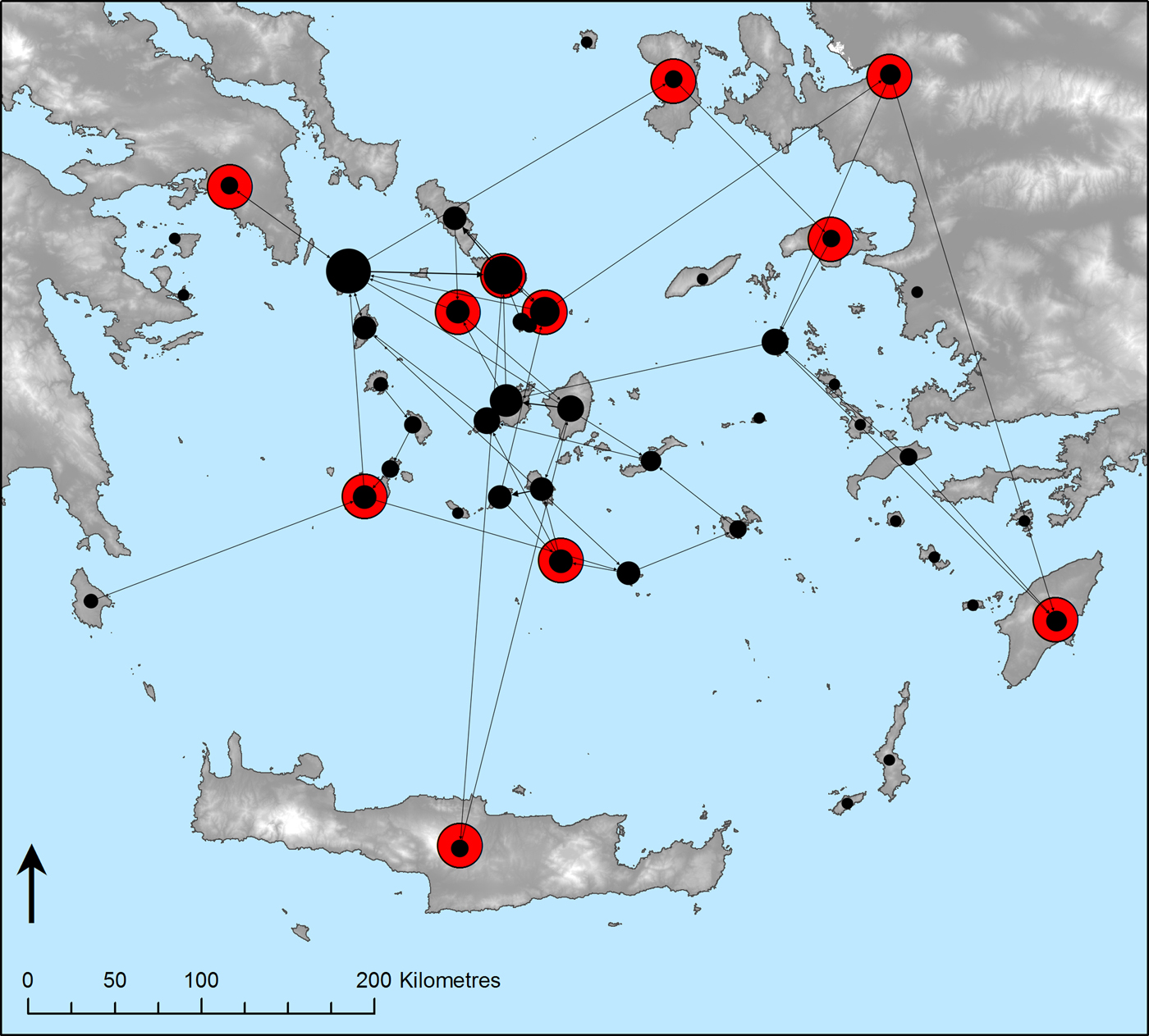
Economic factors clearly played a role in shaping sailing routes, and they provided a suitable platform off the back of which route-makers could piggy-back. The location of consular posts is a good proxy for trade interactions, and it is productive to map these against journeys made by sailors of a certain nationality. The distribution of British consular posts in the nineteenth century (cf. Gunning Reference Gunning2009, 189–95), for example, and the journeys taken by British travellers at this time follow a similar pattern (Fig. 9). There was a high number of journeys made around the consular posts of the northern Cyclades, or, via Keos, between the posts on Syros and Tinos and at Athens; journeys around Crete, Melos and Thera also map onto the location of these posts (but journeys to and from Melos could have been made for the benefit of picking up ‘professional’ pilots there, as discussed above); and posts at Chios, Samos and Smyrna picked up the main flow of traffic around the eastern Aegean. On the one hand, travellers headed for places that already had well-established contacts in the Aegean, and, on the other, they could join on the journeys that were being made by traders and envoys leaving from these places. Travel depended on these pre-existing networks, and it exploited economic and trade networks. The synthesis of a list of consular trade posts or diplomatic services for all nationalities investigated across all centuries is beyond the scope of this study, however, and this point is made only illustratively of a practice that could have been common across the post-medieval Aegean. Furthermore, without conducting a full and detailed analysis on Capitulations,Footnote 32 shipping tax, freight laws, quantities of products shipped, and changes in pricing over time, it is only possible to make here general comments on economic and trade patterns.
Journeys made by nineteenth-century British travellers (black, with node size proportional to the betweenness centrality value of the node), and the location of nineteenth-century British consular posts (red).

Furthermore, the Aegean was a cross-roads for European traders. After travelling into the basin via Kythera from the Ionian Sea, merchants could either continue on the north–south corridor up to the Black Sea, or onwards east to Tyre and Alexandria (summarised by Horden and Purcell Reference Horden and Purcell2000, 138–41). This afforded traders access to grain from the Black Sea, sugar from Crete and Cyprus, spices brought from India, and silk from China, Iran and Lebanon, and it also gave to Aegean communities access to wool cloth, glass, metals and soap brought from Europe (Parry Reference Parry, Rich and Wilson1967, 156–63). As a result, numerous ships passed through the Aegean as part of this trade traffic, both individually and as part of more organised caravane or groups of ships dispatched to conduct economic transactions as a group (Panzac Reference Panzac2004). Economic historians have noted a general pattern that, progressively from the sixteenth century, Mediterranean markets shifted in favour of those from north-west Europe:Footnote 33 smaller quantities of Levantine grain were imported as sources in the Baltic became more preferable; the import of sugar declined; and English and Dutch textiles were traded in greater numbers on Levantine markets than those manufactured in Venice (Cipolla Reference Cipolla and Pullan1968; Rapp Reference Rapp1975; Glamann Reference Glamann, Rich and Wilson1977). Indeed, the establishment of joint stock shipping companies also significantly changed the trade dynamic in the Mediterranean at this time.Footnote 34 The British–Dutch Levantine Shipping Company was established in 1581 (Parry Reference Parry, Rich and Wilson1967, 186–7) with a principle outpost at Smyrna, while French activities extending from here further east to Syria developed from 1612. This accounts for the creation of a formal port here and the increase of traffic through from the seventeenth century onwards: ships passed frequently through nodes at which central and large-scale trade activities were organised. Owing to a variety of factors, therefore, there was some shift (especially by the late seventeenth and into the eighteenth century) of trade and shipping dynamics in the Mediterranean, and even if shipping lanes did not disappear they were used relatively less intensively than they were in the medieval period (Tabak Reference Tabak2008).
The existence of these intensively used trade routes indicates that the Aegean basin (like the regions around it) was full of ships, and that there were ships available in sufficient number which travellers could join for their journeys. It has been taken somewhat for granted that if a traveller wanted to go to the Aegean (or elsewhere) they would have ships available; but the reality is that travel was costly, and that the price could be well met by transporting together people and goods.Footnote 35 There is, then, some correlation between shipping lanes and the routes that travellers took, and it is clear that economic networks played a role in influencing which places travellers were able to access more easily. The pilgrimage route that passed by Kythera, Crete and Rhodes was similar in form to the main east–west trade route established in the medieval period; (French) commercial activities on the coast of Turkey might account for the popularity of the area for travellers from the seventeenth century onwards (Mantran Reference Mantran1962); and by the eighteenth century, as the intensification of trade activities in the Aegean basin and the Mediterranean basin as a whole was shifting, fewer travellers accompanied the long-distance trade ships, and they sought new routes. In some senses, it was not so much where travellers wanted to go; it was more the case of where they were able to go: economic activity and travel in the early modern period were entangled, and the extent of that entanglement shifted over time.
Moreover, the routes along which it was possible to travel depended on political events. Throughout the fifteenth century the Aegean was already well carved up between different groups: Chios, Lesbos and Samos were controlled by the Genoese; the (Venetian-formed) Duchy of Naxos presided over the central Cycladic islands; and the Dodecanese islands were held by the Knights of St John.Footnote 36 The role that the Knights of St John played in providing services for pilgrims has already been discussed, and also the fact that once the island was under Ottoman rule it was still known as a stopover point on longer voyages. Trade ships were still permitted to pass through the various parts of the Aegean, and, even following the fall of Constantinople to the Ottomans in 1453, there was little disruption to seafaring in the region, owing to negotiations conducted between Genoese and Muslim communication networks (Dauverd Reference Dauverd2015). It was in the sixteenth and seventeenth centuries, however, and through the conquering of various Aegean territories by the Ottomans that the face of travel in the region changed most.Footnote 37 Under Ottoman rule, tensions between locals and the new rulers both on the islands and on the mainland led to a rise in privateering – something that was well known to the European travellers (see discussion in Eisner Reference Eisner1990, 52–67). The consequence of this was that some of the travellers passing by en route to the Levant chose to limit their stops in the Aegean, and because of the risks involved in travelling in this area, there was at this time limited travel within the Aegean basin.
Changes in the political-economic environment of Greece in the nineteenth century also had an effect on the way people travelled. Up to the start of the nineteenth century, Greek shippers had for the most part been ‘middleman’ traders in the Ottoman Empire, under the rules and protections of the Capitulations (Harlaftis and Laiou Reference Harlaftis, Laiou and Mazower1988, esp. 17–18). But following the rise of the Greek state, independent Greek trade activities could increase significantly, such that the Greek fleet was the largest set of naval traders in the Mediterranean by the early 1900s (Harlaftis and Kostelenos Reference Harlaftis and Kostelenos2012). The major port of Syros was established in 1822,Footnote 38 at which the Hellenic Steamship Company (HSC) – for which the National Bank paid sizeable capital investment – was based.Footnote 39 Soon after, the port at Piraeus received similar expansion,Footnote 40 and the main shipping activities in and around the Aegean were concentrated around only a few key ports that were served by steamers: Andros, Kalamata, Kephallonia Nauplion, Piraeus, Smyrna, Syros and Volos (Kardassis Reference Kardassis1997, 115–16). Clearly, given that the journeys of travellers depended on ‘piggy-backing’ off existing routes, the major shift in the organisation of economic networks at this time changed the way traveller routes were planned. The handbook compiled by John Murray (Reference Murray1872, 325–6) from other contemporary travel accounts is instructive in this way, recommending to readers at which (English-speaking) hotels to stay on Syros, and of the weekly steamer timetables according to season. Travellers spent less time meandering around the islands, and they moved hastily through this region, with the aim of travelling much further distances.Footnote 41
Summary
What becomes clear from this discussion is that routes in the early modern Aegean were entangled with other sorts of networks. As discussed above, the most effective means of travelling through the Aegean Sea was to join existing voyages, either those that were sailing for pilgrimage (van Ghistele 1482–3; Le Saige 1518; Belon 1547 [all in Yerasimos Reference Yerasimos1991]) or for trade (cf. Fig. 9). These routes, however, were variously hindered or made more navigable by contemporary political events, yet writers seldom acknowledged that anyone apart from themselves had any sort of agency over route-making.Footnote 42 Notably absent from travel accounts are local people employed as pilots or navigators, those who were necessary for navigation in the early modern period, but seldom acknowledged. Furthermore, there is some circumstantial evidence that knowledge was passed on between travellers. Travellers (or their captains) communicated where to stop over on longer voyages to one another either directly or through the production of portolan charts (dalli Sonetti 1485 [Goff Reference Goff1972]; Seller Reference Seller1669 and Reference Seller1671). And through the establishment of elite travelling clubs and the widespread publication of their travel literature, scholars of a certain class were inspired to travel far and wide (Stuart and Revett Reference Stuart and Revett1762; Wood Reference Wood1767; Chandler Reference Chandler1776). Evidence for the sharing of routes between peer networks is circumstantial and often invisible; furthermore, this practice, even though important on a case-by-case basis, played less of a role than the ‘piggy-backing’ outlined above for entrenching the ‘known’ routes along the maritime highways. Corridors of movement were carved out by other sorts of networks, and travellers merely followed routes that had already been set. To a greater or lesser extent, routes and networks, places and journeys were all intertwined across history: the connectivity of places is as much a story of the connectivity of people.
CONCLUSIONS
The main interest of this study has been twofold, with both a methodological and a historical interest. This paper began by discussing how issues of connectivity and mobility are currently of concern to the scholarly community, but also noted that abstract concepts are not so easily defined – nor can they be so easily investigated. Computational modelling can go some way to exploring these issues, but the models most frequently used in landscape archaeology are insufficient for discussing maritime spaces. To address this theme, a novel approach has been proposed that uses the library collection of travelogues from the British School at Athens with SNA and PPA, one that considers together physical and human networks. Subjecting old data to such methodologies has great potential for bringing new patterns to light. Travelogues provide a wealth of information with good chronological resolution on route-making and mobility, and formal modelling unlocks some of the information not so readily visible when texts are read in isolation. This sort of analysis only takes a broad-scale view of the Aegean and is necessarily reductionist, but there is significant merit in reframing legacy collections, and in looking differently at familiar data.
Furthermore, this study has shed greater light on the Aegean basin of the early modern period and on those who travelled in it. Each traveller had their own motivations, but, nevertheless, broad patterns emerge when their texts are read in light of one another. Specifically, there was a shift around the seventeenth century in how the Aegean Sea was navigated. Prior to this date, a majority of the texts written describe how travellers ‘passed through’ en route to places like Jerusalem or Constantinople; from the end of the seventeenth century onwards, however, the Aegean was explored as a place of enlightenment, learning, and Philhellenism. Nevertheless, the precise routes open to travellers depended on other pre-existing networks, such as trade routes. Travellers had to ‘piggy-back’ their way around the Aegean, something that is not always evident from the texts themselves. This narrative is not substantially new – but what this study shows is that the story is statistically consistent across the available evidence, and it has made more patently clear when and where the gravity of central routes shifted. Furthermore, it clarifies that there is consistency between ‘real’ and ‘imagined’ journeys of travellers and armchair travellers of the early modern period; and also that there is consistency in the collection of the BSA library, representative of the larger narrative of travel writing in this period. Travel texts and maps expressed a western-centric and etic perspective. The people who wrote these texts were all elite and of a certain class; the travelogue record excludes the local people who lived in the Aegean basin at this time, those who would have had a much better knowledge of the Aegean Sea and its navigability. Ironically, these travellers were almost entirely dependent on the people they never wrote about. The results of this analysis demonstrate, therefore, elite western mobility, rather than connectivity per se. It now remains to consider how these patterns would change if a larger geographic dataset were investigated (e.g. to include material relating to the northern Aegean or places east or west of the basin), or if more Venetian, Genoan or Ottoman sources were analysed (i.e. more ‘local’ perspectives).
This study has made creative and effective use of the collections and legacy data of the British School at Athens, in line with the scholarly aims of the institution. It has provided a challenge to use data in different ways, and to mobilise texts at different scales in order to see what patterns emerge. The results here have aimed to be historically significant and to help us reframe some of the big debates that currently face the field – the unpicking of big thorny issues of mobility and connectivity.
ACKNOWLEDGEMENTS
This research was conducted while I was a PhD student at the Faculty of Classics, Cambridge, and it was generously funded by the Arts and Humanities Research Council and Pembroke College. Additional funding from the Henry Arthur Thomas fund made travel to Athens possible. I thank most wholeheartedly Penny Wilson and Sandra Pepelasis for their help navigating the BSA collections, and I am grateful to them for granting me access to the rare books room. Early drafts of this paper were read by Graham Andrews, Toby C. Wilkinson, and two anonymous reviewers, and Alexandra Katevaini gave suggestions for improving the Greek abstract.