1. INTRODUCTON
Traffic control and traffic information services rely on accurate and timely information about the status of the road network. Conventional estimation of the traffic queue lengths is no longer sufficient for the reasonable prediction of travel time. Traditionally, the traffic status on a road network is derived from local measurements, for instance those collected by induction loops or visual systems. However, it is difficult to obtain an accurate estimation of the instantaneous travel time from the local traffic speed and flow data (Fukui and Sugiyama, Reference Fukui and Sugiyama2002). Empirical observations on the spatial-temporal structure of the traffic flow have revealed inherent complexities both on microscopic and macroscopic levels (Kerner, Reference Kerner2004).
In recent years, dynamic sensor technology has been widely used in many traffic status recognition applications. Floating car data (FCD) is one of the methods used to determine the traffic speed on the road network. It is based on the collection of the locations, speeds and directions from widely distributed driving vehicles to derive the instantaneous travel time on the road network. For example, the signals received by in-vehicle GPS receivers are processed and a lot of useful derivatives such as current position, velocity, acceleration, etc. can be derived. These data are essential for traffic planning and management as well as the establishment of an Intelligent Transportation System (ITS). This means that every appropriately equipped vehicle could act as a moving platform for the collection of instantaneous traffic information about particular segments of entire road network. Based on these data, the degrees of traffic congestion can be estimated, the road segment travel times can be calculated, and current traffic reports can be generated and disseminated.
Since a previous trial was successfully conducted to inform the vehicle users about the instantaneous traffic status during 1998 and early 1999, various FCD based applications have rapidly evolved around the world (Turksma, Reference Turksma2000). A Taxi-FCD system developed by the German Aerospace Centre has been delivering traffic information to a variety of users since April 2001 (Lorkowski, Mieth and Schäfer, Reference Lorkowski, Mieth and Schäfer2005). This project introduced a new FCD approach for collecting traffic information by commercial fleets such as taxis. The IFlorida project in Florida, USA, has integrated FCD into its traffic management system (Hodges, Reference Hodges2005). Provided by Honda, Internavi Premium Club has adopted FCD to distribute traffic flow status data through Google Earth, providing its customers much more travel freedom (Tanokura and Electronics, Reference Tanokura and Electronics2006).
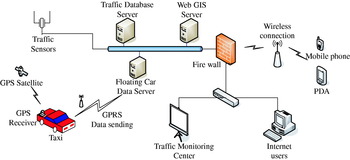
Existing studies have focused more on the conceptual and the structural establishment of FCD. However, for a practical application, some problems such as system integration and ocean data storage management need to be solved. The work described in this paper is based on the successful implementation of the Shenzhen Urban Transport Simulation System (SUTSS) project in China. The SUTSS project received sponsorship from local government and was organised by Shenzhen Urban Transport Planning Centre (SUTPC). Tongji University is one of the main system developers. In the design of SUTSS, traffic measurements collected by the FCD approach are also used to support traffic pattern recognition. As the first successful FCD project for the urban transportation simulation in China, new methods have been widely used in the SUTSS project. Meanwhile, SUTSS is utilized for the traffic information service, which involves the development of a dedicated spatial database and its web publication based on a Geographic Information System (GIS). The structure of SUTSS is shown in Figure 1.
System structure of SUTSS.

Through the development of SUTSS, this paper presents the processes and algorithms for the computation and map-matching of instantaneous road segment velocity. To unify different coordinate systems, the coordinate transformation is discussed first and transformation precision is analyzed. Secondly, due to the character of GPS-based FCD, the coordinates can be collected continuously at a predefined sampling rate, algorithms using probability and statistical theories are developed and employed for the map-matching of instantaneous velocity to the road segment. To verify the reliability and accuracy of the proposed map-matching technique, the confidence levels of map-matching are estimated, from which it can be determined whether positioning data is valid or not with predefined threshold values. Thirdly, the road segment velocity matching approach using Metropolis criteria is extended by the authors to account for historical traffic information which is validated by the real-life velocity measurements and has demonstrated high matching correlation. The implementation of FCD and the web Geographical Information System (GIS) based traffic information service which acts as the final structure of SUTSS is further discussed and presented in the final part of this paper. The paper ends with discussions, conclusions and recommendations.
2. FCD APPROACHES
There are two approaches for the collection of FCD, i.e. the passive and active FCD approaches (Lorkowski, Mieth and Schäfer, Reference Lorkowski, Mieth and Schäfer2005). Passive FCD extraction means the recognition of a vehicle at one section of the road network and later on at another section, e.g. by automatic vehicle identification or passive onboard transponders responding to roadside stationary beacons. The time interval between the events allows an estimation of the average travel time between the two sections. The active FCD extraction method requires a positioning system such as GPS and a wireless communication unit onboard the car. The instantaneous position of the car is transmitted at regular intervals to a data server. The location of the car is then superimposed onto the digital road network by map matching and the routing velocity is further obtained through the calculation of the road segment travel time which is estimated by the distance travelled by the cars. For the above implementations a detailed digital road map database is developed and contains well organised features with strict topological relation to support various operations to its spatial and temporal features.
The idea of using cars as the traffic information collection sensors appeared in the 1980s, and gained impetus with the advent of modern wireless communication technologies (Kerner, Demir, Herrtwich, Klenov, Rehborn, Aleksic and Haug, Reference Kerner, Demir, Herrtwich, Klenov, Rehborn, Aleksic and Haug2005). However, both FCD extraction approaches are very costly in terms of hardware and infrastructure requirements as well as communication effort, and these were the main obstacles impeding the introduction of this technique on a larger scale. These obstacles can be bypassed by using position data from commercial vehicle fleets.
FCD is one important data source for the establishment of a traffic information system. The original variable of this system is the vehicle velocity. The work by Gössel, Michler and Wrase (Reference Gössel, Michler and Wrase2003), analyzed the measured vehicle velocity through the transmission and processing of FCD collected by a limited number of data resources (vehicles). Practical data management techniques which include data pre-processing, data modelling and indexing were proposed by Brakatsoulas, Pfoser and Tryfona (Reference Brakatsoulas, Pfoser and Tryfona2005a) to support the analysis and the data mining of vehicle tracking data. In the meantime, some algorithms such as that considering the trajectory of a moving vehicle rather than simply the current position as in the typical map-matching case were presented, and an incremental algorithm was proposed that matched consecutive portions of the trajectory to the road network, effectively trading accuracy for speed of computation (Brakatsoulas, Pfoser, Salas and Wenk, Reference Brakatsoulas, Pfoser, Salas and Wenk2005b). Fouladvand and Darooneh (Reference Fouladvand and Darooneh2005) presented the statistical results of the empirical floating car data. Their investigations were based on an analysis of the time series of four basic parameters, namely velocity, velocity difference, spatial gap and acceleration associated with some instrumented cars and the relevant statistical characteristics, including the mean, variance and relative variance of these time series, were obtained by taking direct time averages.
For the ease of fleet management, about 4000 taxis in Shenzhen City were already equipped with GPS receivers and wireless communication devices before the development of the SUTSS project. They transmit their position periodically to the taxi control centres. The transmission frequency depends on the status of the taxi (occupied, free, waiting, etc.) and the average interval is currently set to 1 minute. Each data record contains a taxi identity number, the time, the GPS position and the taxi status. During the SUTSS project development these taxis, from different taxi companies, were requested by the Shenzhen Government to share the positioning data with the SUTSS project developers. Processing taxi FCD starts with the elimination of implausible (e.g. mismatched GPS positions) and irrelevant (e.g. from taxis waiting for customers) data.
Since May 2006, millions of GPS data sets from these 4000 taxis have been recorded and used as an excellent basis for dynamic time routing. Instantaneous travel time within Shenzhen City was also estimated and published through WebGIS-based instantaneous traffic information with dissemination over the Internet. From these GPS data sets, a synergy for traffic monitoring and forecasting could be achieved when the driving velocity of each taxi was map-matched with the road network and the average velocity of each road segment estimated. For instance, the traffic congestion information is disseminated in near real-time (an interval of 2 minutes) to the end users who with an Internet connection can access such information on a digital road network where the velocities on road segments are plotted using different colours.
3. COORDINATE TRANSFORMATION
The positioning contents of FCD sent to the traffic centre are geodetic coordinates in the WGS84 coordinate system, while the road network digital map is based on the local Gauss plane coordinate system. Coordinate transformation is required to link these two coordinate systems together. For convenience in the implementation and computation, coordinate transformation from the WGS84 system to the local Gauss plane coordinate system was chosen in the system development.
3.1. Fundamentals
After the transformation, FCD coordinates in the Gauss plane coordinate system are obtained. However, after the map projection, there are still discrepancies between these Gauss coordinates with the coordinates in a local plane coordinate system. Therefore, an affine transformation is utilised here to reduce these discrepancies as described in Equation 1:
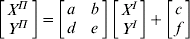
Where,  and
 are the FCD coordinates in the local plane coordinate system and the Gauss plane coordinate system, respectively, and a,b,c,d,e,f are the transformation parameters.
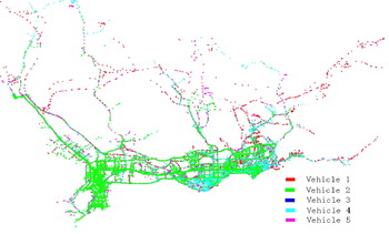
As a case study, we transformed the FCD of five cars collected during one month of test driving into the Shenzhen local plane coordinate system, and obtained the road network shown in Figure 2. Different colours are used to describe each car's trajectory over the month.
Shenzhen road network formed by transformed FCD of five cars.

3.2. FCD transformation precision analysis
Equation (1) shows the process to transform FCD coordinates from projected Gauss plane coordinates to those in the local plane coordinate system. However, the six transformation parameters a,b,c,d,e,f are unknown. To solve these unknowns, Equation 1 is altered as Equation 2 (an observation equation):


X=[a b c d e f]T. X° is the initial vector of X.
At least three control points are needed to solve the initial vector Equation (2). If more control points are selected, the least-squares criteria can be used to find the optimal estimation of the transformation parameters. To estimate the coordinate transformation precision, the standard deviation for the estimation of the transformation precision is used and is expressed as Equation 3:
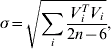
where, 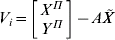 .
 are the optimal estimations of the six transformation parameters, n is the number of control points and i stands for the i−th control point. Therefore, the transformation precision FCD coordinates in each area can be described by σ. To complete the coordinate transformation process, the transformation parameters needed to be solved first. 112 control points were chosen to solve the optimal transformation parameters for the whole of Shenzhen City and the result is listed in Table 1.
Transformation parameters of FCD.

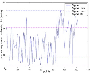
The calculated standard deviation of the unit weight is 0·807 m. The least residual error of all control points is 2·194 m by the approach of comparing original coordinates with the transferred coordinates. Actually, these control points are not the ones surveyed by a conventional geodetic approach. They originate from the local large scale digital road network map by matching the points that can be easily identified such as road intersections. Due to the mosaic effect, their relative relationship in the road network cannot be exactly matched and hence the transformation precision is limited to a level of several metres.
Since FCD obtained from a moving receiver is about 10 m, the transformation precision is accurate enough to transform a FCD into the urban local Gauss plane coordinate system. In the actual project, this coordinate transformation method played an important role for map-matching instant car locations onto the digital map.
Figure 3 shows the statistical result of root-mean-square (RMS) errors of all the control points, in which Sigma refers to the RMS error of each point and it can be seen that most RMS are within 2 Sigma.
Statistical result of root-mean-square errors of all the control points.

4. MAP-MATCHING TECHNIQUE
Although the measured coordinates in WGS84 can be transformed as the coordinates in a special coordinate system, due to the errors in GPS surveying, such as ionosphere delay, multipath effect, satellite signal obstruction etc., FCD might fail to fall exactly on the road segments of a digital map. To rectify the errors, the integration of instantaneous locations of the positioning sensors and digital road map is inevitable and a map-matching technique is required for this purpose.
4.1. Methods used for match-matching
A road network can be defined as a combination of arcs. An intersection of roads is called a node and an arc between two nodes is called a road segment. The determination of the arc from which FCD is most likely collected is to locate the vehicle position on the arc. The former is called Road Identification and the latter can be called Position Match.
Map-matching is a technique that attempts to locate a vehicle on a road map which consists of Road Identification and Position Match (Zhao Reference Zhao1997). Many map-matching algorithms have been developed in recent years and widely incorporated into GPS vehicle navigation systems for both commercial and experimental ITS applications. However, the reliability of these systems is still a problem. Vehicle position may be located to an incorrect road section due to the large vehicle positioning errors which occur very frequently in urban areas where gaining sufficient GPS signal reception always poses a challenge. The incorrect positioning location is called a mismatch. To improve map-matching techniques, it is necessary to enhance the ability of mismatch detection and reduce the chance of mismatch, which are called integrity and reliability, respectively.
Until now, three types of map-matching algorithms have been developed i.e. geometric map-matching method; a map-matching method based on probability and statistics theory; and a map-matching method based on fuzzy logic (Zhao, Reference Zhao1997). Recently, research by Ochieng, Quddus and Noland (Reference Ochieng, Quddus and Noland2003) has demonstrated improved map-matching algorithms that take account of the vehicle speed and the error sources associated with the navigation sensors. Further work has been carried out by the same authors to obtain a higher accuracy reference of the vehicle trajectory as determined by high precision positioning from GPS (Quddus, Noland and Ochieng, Reference Quddus, Noland and Ochieng2005).
4.2. Map-matching method considering historical positions
In the situation where the sample data is mainly obtained from FCD, a new map-matching method is proposed by considering the historical positions of floating cars. Due to the nature of FCD, the positions collected with GPS can be recorded continuously. Map-matching of these data sets is significantly different from that of a more traditional FCD approach. In this new approach, not only are the probability algorithms employed, but also the historical positions of the vehicles are considered. In this way, under more realistic hypotheses such as the change of the positions of a moving vehicle is continuous, map-matching can be achieved to a higher precision.
The following two principles are proposed by the authors to ensure the success of the new map-matching technique:
1. Candidate road segments are selected, based on FCD historical positions, and
2. The most recent velocity of a car approximates to its historical average velocity.
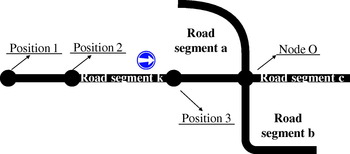
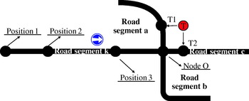
Under the first principle, it is assumed that the road segments are continuous and the car is running along road segments. For example, in Figure 4, a car is running on the road segment k, and its historical positions are recorded as: Position 1, Position 2, Position 3 and so on.
Candidate road segments are selected based on the FCD historical positions.

From Figure 4, the next possible road segments that this car could run onto are the road segments that share a common Node O. Therefore, based on the assumption that FCD is sent to the data centre in a relatively short time and the car is running normally, the candidate road segments can be limited to the road segments a, b and c. In fact, this assumption can always be realistic and with this principle a more efficient and accurate map-matching technique can be achieved.
Based on Principle 1, a FCD T is matched onto the road segment a and road segment c. Matched points are expressed as T1 and T2 respectively in Figure 5. Statistically, both T1 and T2 are correct candidate matching positions.
Validating the matching positions with FCD historical velocity.

To validate the actual road segment that a car has entered, Principle 2 is further utilised. The distance between position 3 and T1 along the road segments is calculated and notated as s 1 and the distance between position 3 and T2 is expressed as s 2. Therefore, velocities v 1 and v 2 can be calculated as:

A criterion can be established to determine the correct matching point. The differences between v i and v average:

where, v average is the average velocity along the road segment. The matching point is then determined for the one with smaller Δv i, indicating that it approximates to the average velocity most likely.
5. ROAD SEGMENT VELOCITY MATCHING
5.1. Metropolis criteria
The Metropolis algorithm was proposed by Metropolis to apply Monte Carlo algorithms to simulate the heat balance process of the solid object (Metropolis, Rosenbluth, Rosenbluth, Teller and Teller, Reference Metropolis, Rosenbluth, Rosenbluth, Teller and Teller1953) under certain temperatures. The whole algorithm can be described as follows:
• The initial state of a particle is i and the corresponding energy is E i.
• Disturb state i and obtain a new state j. The corresponding energy is E j.
• For arriving at the least energy state, if E j<E i, the new state is regarded as the important state. If E j<E i, whether we should accept the new state as the important state depends on the probability of the particle's state.
Here Metropolis introduced criteria:
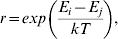
where, r is between 0 and 1, k and T are two constant values defined by the user. ξ is a random value in [0,1], and the following judgments can be made:
(a) If r>ξ, state j is accepted as the “important state”.
(b) If r<ξ, state j is not accepted as the “important state”.
After the state of the particle transfers significantly, the system approximates to a balanced state with a relative energy.
5.2. Road segment velocity matching considering Metropolis criteria
The traffic flow in a day differs significantly for different time periods. In this research a day is divided into 24 hours and in each hour i, a standard road segment velocity  is assigned to each road segment k. In the actual applications, can be described as the historical average velocity on the road segments.
Road segment velocities can be easily obtained from FCD. However, within one hour intervals there could be many velocities for one road segment. The easiest way to get the current velocity of one road segment is to average all those velocities. However, due to many incidental reasons such as delay caused by traffic lights, drivers' own affairs etc., this average velocity could not reflect the actual status of the road segment. Therefore, an algorithm for road segment velocity matching using the Metropolis criteria is proposed.
For each road segment k in hour i, a threshold T ik can be set up and assume that the velocity change will not surpass this value. We define:

where, V ikm is a sample velocity calculated from FCD in road segment k in hour i. P ikm is its corresponding weight.
For each road segment k in hour i, we can obtain a series of sample cars' velocities with above weights, and the current velocity for road segment k in hour i can be calculated as:
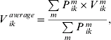
where, V ikaverage is noted as the current average velocity for road segment k in hour i by considering weights.
5.3. Validation of road segment velocity matching
In order to validate the matched road segment velocity, a real road segment velocity survey was conducted. The real running time and the time delay of vehicles were used to calculate the real average road segment velocity, and it was then compared with the computed road segment velocity extracted from the SUTSS. The compared results can be used to address the achievable accuracy of the data capture by FCD and the modelling computation.
The running time on each road segment was recorded by a stopwatch by registering the start and end time on the road. The real road segment velocity was then obtained by dividing the road length by the actual running time, and expressed as Equation 9:

where, V n is the vehicle speed at a certain road segment; T n and T n+1 are the time tags of two junctions at a certain road segment, and L n is the length of a certain road segment.
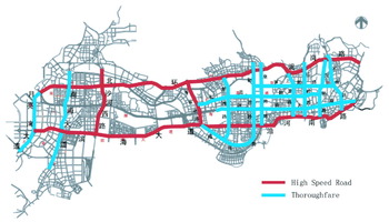
The road running time validation was carried out from 9 to 15 December 2006, which was five working days and one weekend, representing good time coverage. The total investigated road length is 254 km, of which 116 km are urban high speed road and 138 km are thoroughfare. The road coverage and its classification are shown in Figure 6, and the relevant statistical data is given in Table 2.
Road coverage map of the validation of road segment velocity.

Field investigation of the road segment velocity.

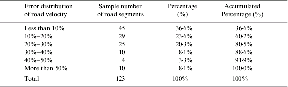
The results of this field investigation are described by the error distribution of the road velocities, through the comparison of real velocities with computed velocities. The error distribution of the road velocity is given in Table 3 for the whole testing road data set.
Error distribution of road velocity for the whole testing roads.
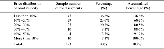
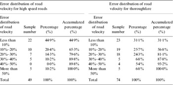
Actually, the result for the high speed road is different from the result for the thoroughfare, and the road segment velocity matching of high speed roads has slightly better consistency with the real testing result. For the error distribution of the road velocities, the comparison is classified into high speed road and thoroughfare, and result is given in Table 4 respectively. It can be seen that the road segments with the velocity error less than 30% can reach 79·6%, whilst the road segments with the velocity error less than 40% can reach 89·8% for high speed roads. For the thoroughfare roads, the road segments with the velocity error less than 30% can approach 81·1%, whilst the road segments with the velocity error less than 40% can approach 87·8%.
Error distribution of road velocity for different types of roads.

6. WEBGIS-BASED TRAFFIC INFORMATION SERVICES
6.1. Flow Chart of WebGIS-Based Traffic Information Services
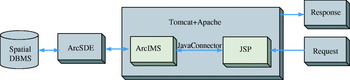
As designed, the instantaneous traffic information is published over the Internet for the end users to access. J2EE frame was adopted for the design of the whole website and the map publication was accomplished by the ArcIMS application server. Apache and Tomcat are adopted respectively as the Web Server and Servlet Engine in our case study. The logical structure of the WebGIS traffic information services is as described in Figure 7.
The architecture of WebGIS based traffic information services.

6.2. Data storage and management
As an excellent RDBMS, Oracle not only supports storage and management of attributes, but also facilitates operations on spatial data. In the current version, Oracle 9i/10g also supports some special data types such as SDO_GEOMETRY for storing spatial data and building topological links. In the WebGIS system, Oracle10g is utilised to combine spatial and feature data into one unique database. To facilitate and secure the operations on Oracle, ArcSDE is used as the middle component. ArcSDE is the product of ESRI, which can provide a suite of services that enhance data management performance, extend the range of data types that can be stored in a RDBMS, enable scheme portability between RDBMSs, and offer configuration flexibility. The road network is described in a shape file format. Through ArcSDE, the shape files have been imported into Oracle, and the following operations on those spatial data are based on ArcSDE.
6.3. WebGIS-based traffic information publication
The instantaneous traffic visualization is vital to the users of traffic pattern recognition. In this application, we adopt ESRI's products to publish our traffic flow map over the Internet, and the website for accessing the instantaneous traffic information is: http://www.sutpc.com.
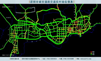
ArcIMS, also the product of ESRI, is the solution for delivering dynamic maps with GIS data and services via the Web. With ArcIMS, the instantaneous traffic flow map could be delivered on the Internet. Especially, its java-connector supports further system development. Whilst J2EE frame is adopted for the system design, JSP is used to represent the traffic information. Figure 8 is an interface for the display of instantaneous traffic flow maps. In this figure, the red colour indicates complete traffic blockage, yellow stands for road congestion, and green means clear of obstruction.
Shenzhen traffic flow map.

Since the system is based on FCD, it is dynamic as FCD is received in real time. Therefore, for every five minutes, the road segment velocity is updated in the Oracle database and the traffic flow map is also updated correspondingly. It is very useful for the traffic administrative departments to make reasonable future traffic plans to alleviate the traffic congestion; the end users with proper Internet access can visit the above website to obtain instantaneous information about road traffic status for his/her travel plan.
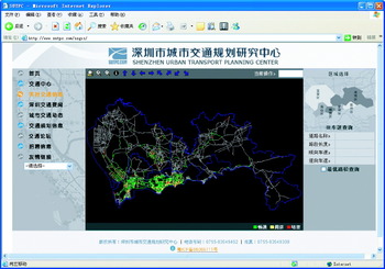
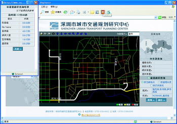
The WebGIS traffic publication could provide flexibility to explore different levels of detail about road velocities through zoom in, zoom out and query operations. A detailed real time traffic status map for the whole Shenzhen City is presented in Figure 9. The current velocity on each road segment can be obtained just by clicking onto the road segment. Furthermore, optimal journey plan could be achieved by considering the present traffic situation and the historical traffic status. The end user could decide to approach the destination by using either the shortest time or the shortest route length algorithm on the Internet before his/her departure, and one of the query results is shown in Figure 10.
An illustration of the detailed traffic present situation web service.

An illustration of the trip guidance web service based on the dynamic traffic situation.

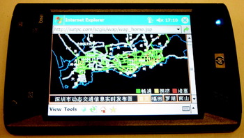
Such web-based instantaneous traffic services can also be obtained using a mobile device such as a PDA or a GSM/GPRS enabled mobile phone. A WAP service based on FCD is specially designed for mobile users, and Figure 11 is an example interface.
Mobile WAP service for the dynamic traffic status.

7. CONCLUSION
As a new form of data source, Floating Car Data has become more and more important in the instantaneous traffic information acquisition and traffic pattern recognition. With the support of WebGIS, it is also vital to release the real-time traffic information over the Internet and update it automatically for a variety of users including decision makers and travellers. Through recording the positions of 4000 GPS equipped taxis in Shenzhen, a southern city of China which borders Hong Kong, the traffic status in the city can be drawn through the calculation of road segment velocities. The GPS positions of associated taxis are analyzed in terms of their route trajectories and speed status. The project of Shenzhen Urban Transport Simulation System (SUTSS) represents the first successful instantaneous traffic information system in China by integrating FCD and WebGIS service technology. As one of the most modern cities in China, Shenzhen now benefits greatly from the SUTSS through better traffic control, based on the instant provision of timely traffic information on the road network. Through the development of SUTSS project, this paper focuses on the key issues such as how to process FCD and establish WebGIS-based instantaneous traffic publication. In particular, this paper discusses the coordinate transformation, map-matching approach considering historical FCD and road segment velocity matching with Metropolis criteria which ensure the success of this project. All these algorithms and methods proposed by the authors are taking the character of FCD into account, and the field investigation data further proves the validation and reliability of SUTSS. Actually, as a part of ITS, the WebGIS-based real time traffic publication could satisfy not only the demand of traffic planning decision makers but also the need of public users for their journey plans. However, the optimal journey plan according to the time optimization and distance optimization or historical average time optimization will be considered as updates to the SUTSS in future work. Meanwhile, fusion of multi-sensor data will be realized further to improve the accuracy of traffic information description.
Acknowledgements
The work described in this paper was supported by National Natural Science Foundation of China (Project No.40501061), and the data are provided by SUTSS (Shenzhen Urban Transport Simulation System) project in China. The authors would like to thank Prof. D.Y. Yang, Prof X.H. Chen and Prof. H.F. Lin from Tongji University of China for their valuable work. The author would like to thank Norman Bonnor from Nottingham University for his comments and suggestions which helped to improve this paper.