One of the intriguing aspects of the geological evolution of Antarctica is the large volume of intracontinental igneous rocks that were emplaced during the Mesozoic and Cenozoic. This is in marked contrast to the Palaeozoic, which was almost devoid of intracontinental igneous activity and during which time Antarctica was located almost centrally within Gondwana. The emplacement of the Mesozoic igneous provinces was contemporaneous with the gradual breakup and disintegration of Gondwana, leading eventually to the isolation of Antarctica in a south polar position. What is even more notable is that Antarctica itself continued to rift after it was isolated in its south polar position, forming the West Antarctic Rift System (Behrendt et al. Reference Behrendt, LeMasurier, Cooper, Tessensohn, Tréhu and Damaske1991), with emplacement of related igneous rocks.
The link between the emplacement of the igneous rocks in Antarctica, rifting and continental breakup processes remains enigmatic (Storey Reference Storey1995; Rosenbaum et al. Reference Rosenbaum, Weinberg and Regenauer-Lieb2008). The potential link between large igneous provinces and plate tectonic processes has been considered because many of the Mesozoic provinces were located close to once active plate boundaries and continental margins. Alternatively, the magmatic pulses responsible for producing large volumes of igneous rock in relatively short periods of time have also been related to some form of internal heating (thermal anomaly) in the Earth's mantle, due either to the insulation of the Gondwana supercontinent (e.g., Gurnis Reference Gurnis1988; Coltice et al. Reference Coltice, Phillips, Bertrand, Ricard and Rey2007), or a mantle-sourced thermal upwelling, i.e., mantle plume (Morgan Reference Morgan1971, Reference Morgan and Emiliani1981; Richards et al. Reference Richards, Duncan and Courtillot1989). Mantle plumes may either have caused the continents to rift and break up (active mantle hypothesis, Morgan Reference Morgan1971) or have been unroofed by chance due to plate tectonic processes causing continental break-up (passive mantle hypothesis, White & McKenzie Reference White and McKenzie1989). Although the Gondwana magmatic provinces are mainly mafic in composition, large silicic provinces also exist, part of which are present in Antarctica (Pankhurst et al. Reference Pankhurst, Leat, Sruoga, Rapela, Márquez, Storey and Riley1998).
This paper will review the connections between the emplacement of the large igneous provinces in Antarctica formed during the Mesozoic and Cenozoic and the relationship of these to the break-up of Gondwana. A central question is whether these huge manifestations of basic magmatism were associated with notable positive thermal anomalies in the subcontinental upper asthenospheric mantle (e.g., Richards et al. Reference Richards, Duncan and Courtillot1989; White & McKenzie Reference White and McKenzie1989; Johnston & Thorkelson Reference Johnston and Thorkelson2000; Thompson & Gibson Reference Thompson and Gibson2000; Coltice et al. Reference Coltice, Phillips, Bertrand, Ricard and Rey2007) or whether they formed by decompression melting related to plate tectonic processes (e.g., King & Anderson Reference King and Anderson1995; Anderson Reference Anderson2000, Reference Anderson2005; Elkins-Tanton Reference Elkins-Tanton, Foulger, Natland, Presnall and Anderson2005; Foulger Reference Foulger, Foulger and Jurdy2007). For this reason, petrogenetic models for the formation of the igneous provinces are reviewed. The paper will also consider the impact of the formation of the igneous provinces on the Earth System in general. Large igneous province eruptions are implicated in environmental and climatic changes including global warming, oceanic anoxia and/or increased oceanic fertilisation, calcification crises, mass extinction and potentially the release of gas hydrates (Hesselbo et al. Reference Hesselbo, Grocke, Jenkyns, Bjerrum, Farrimond, Bell and Green2000; Wignall Reference Wignall2001; Wignall et al. Reference Wignall, Newton and Little2005). Although the volume of igneous rocks emplaced during the Mesozoic and Cenozoic evolution of Antarctica may not, in some cases, strictly be of sufficient volume for them to be classified as large igneous provinces (LIPs), nevertheless they are included here as they are clearly related to Gondwana rifting and subsequent breakup. We first present details of the Antarctic igneous provinces, including their petrogenesis, and then consider their links to continental break up processes. Central to the debate concerning the origin of any large igneous province is establishing whether a mantle plume source existed and determining whether the role of the plume was restricted to conductive heat transfer to the lithosphere, or whether uncontaminated plume-derived magmas were erupted at the surface or intruded at upper crustal levels.
1. Antarctic intracontinental igneous provinces
1.1. Ferrar magmatic province
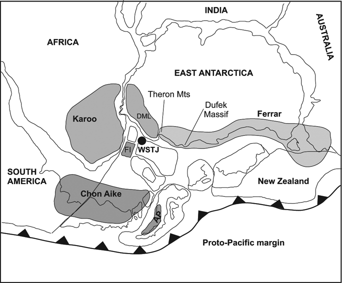
The Middle Jurassic (180·3±2·2 Ma; Heimann et al. Reference Heimann, Fleming, Elliot and Foland1994) Ferrar magmatic province in Antarctica is predominantly a mafic sill complex, but includes flood basalts (Elliot et al. Reference Elliot, Fleming, Kyle and Foland1999), phreatomagmatic volcanic rocks (Elliot & Hanson Reference Elliot and Hanson2001), mafic dykes (Fleming et al. Reference Fleming, Elliot, Jones, Bowman and Siders1992; Leat et al. Reference Leat, Riley, Storey, Kelley and Millar2000) and layered mafic intrusions (Storey & Kyle Reference Storey and Kyle1997). It has a linear outcrop and extends 3500 km from the Theron Mountains of Antarctica to southeast Australia (Fig. 1) (Elliot & Fleming Reference Elliot and Fleming2004). Its linear outcrop pattern is unusual among LIPs, but the extent to which the elongate outcrop is a function of ice-cover limiting the outcrop is uncertain (Leat Reference Leat2008) and there is geophysical evidence indicating a greater extent of Ferrar province rocks under the East Antarctic Ice Sheet (Ferraccioli et al. Reference Ferraccioli, Coren, Bozzo, Zanolla, Gandolfi, Tabacco and Frezzotti2001). Its main outcrops are in Antarctica (Kyle Reference Kyle1980; Kyle et al. Reference Kyle, Elliot, Sutter, Cresswall and Vella1981), but it also occurs in southeast Australia, (Hergt et al. Reference Hergt, Chappell, McCullagh, McDougall and Chivas1989a) New Zealand (Mortimer et al. Reference Mortimer, Parkinson, Raine, Adams, Graham, Oliver and Palmer1995), and South Africa (Riley et al. Reference Riley, Curtis, Leat, Watkeys, Duncan, Millar and Owens2006). The total volume of lava and intrusions in the Ferrar Province is estimated to be around 200,000 km3, allowing 60,000 km3 for the Dufek–Forrestal intrusions, 125,000 km3 for sills, lavas and dykes in Antarctica, and 15,000 km3 for sills in Tasmania (Hergt et al. Reference Hergt, Chappell, McCullagh, McDougall and Chivas1989a; Elliot & Fleming Reference Elliot and Fleming2000). This is a considerable reduction from early estimates of 500,000 km3 (e.g. Kyle et al. Reference Kyle, Elliot, Sutter, Cresswall and Vella1981), following a reinterpretation of the extent of the Dufek and Forrestal intrusions based on aeromagnetic surveys (Ferris et al. Reference Ferris, Johnson and Storey1998).
Middle Jurassic Gondwana reconstruction showing three large igneous provinces, Ferrar, Karoo and Chon Aike (after Storey & Kyle Reference Storey and Kyle1997), and the location of the Weddell Sea Triple Junction (WSTJ) after Elliot & Fleming Reference Elliot and Fleming2000. Abbreviations: AP=Antarctic Peninsula; DML=Dronning Maud Land; FI=Falkland Islands.

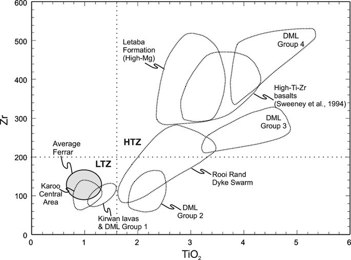
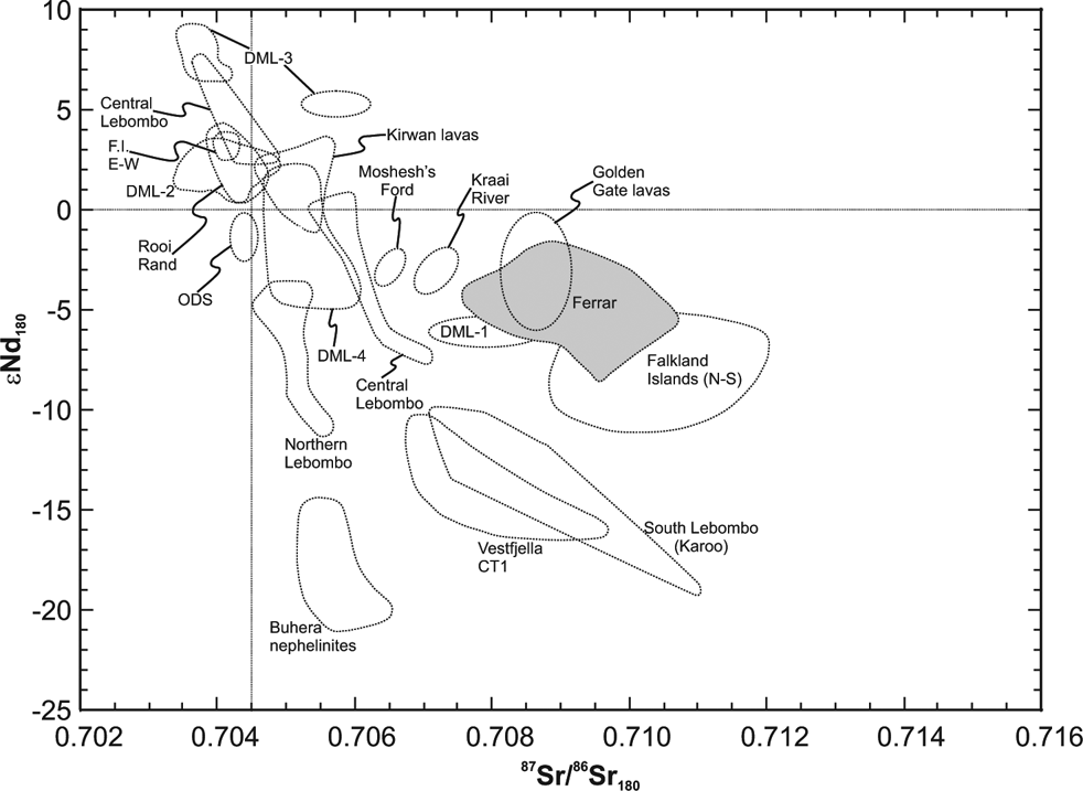
As a result of detailed 40Ar/39Ar and U–Pb geochronology, the synchronicity of the Ferrar and Karoo province in southern Africa has long been recognised (e.g. Encarnación et al. Reference Encarnación, Fleming, Elliot and Eales1996; Pálfy & Smith Reference Pálfy and Smith2000; Riley & Knight Reference Riley and Knight2001), although the peak (based on a compilation of age dates) of Karoo magmatism at 183±2 Ma is 3 Myr older than the Ferrar peak of 180·3±2·2 Ma. Although closely spaced in time, the rocks of the Ferrar and the Karoo volcanic provinces are markedly different in their geochemistry. The basalts of the Ferrar province are entirely of low-Ti–Zr type and are typically high SiO2 compared to the once neighbouring Karoo province (Fig. 2). Other key features of the Ferrar Province are Sr and Nd isotope ratios, with Ferrar basalts having initial (87Sr/86Sr)180 ratios in the range 0.708–0.711, and εNd180 values in the range −2 to −8 (Fig. 3). These isotopic characteristics of the erupted rocks of the Ferrar province, coupled with the high SiO2 (50–52 wt%) and high concentrations of the large ion lithophile elements, have led several workers (e.g. Antonini et al. Reference Antonini, Picciirillo, Petrini, Civetta, D'Antonio and Orsi1999) to suggest that processes involving contamination of the magmas by continental crust was important, whilst other workers (e.g. Kyle Reference Kyle1980; Hergt Reference Hergt2000) maintain that the continental crust was not involved in the petrogenesis of Ferrar magmas. Molzahn et al. (Reference Molzahn, Reisberg and Wörner1996) suggested that their ‘mantle-like’ Os isotope ratios and their radiogenic 87Sr/86Sr are characteristics of their mantle source.
Variation in Zr vs TiO2 for dyke and lava compositions from the Karoo (Kirwan lavas, Karoo central area, Rooi Rand dyke swarm, Letaba Formation, Lebombo high Ti–Zr basalts) and Dronning Maud Land provinces (DML groups 1–4) and average Ferrar compositions. Data sources in Riley et al. (Reference Riley, Curtis, Leat, Watkeys, Duncan, Millar and Owens2006). Abbreviations: HTZ=high Ti zone; LTZ=low Ti zone.
Initial εNd and 87Sr/86Sr for intrusive rocks and lavas from the Karoo and Ferrar magmatic provinces. All data sources are available in Riley et al. Reference Riley, Curtis, Leat, Watkeys, Duncan, Millar and Owens2006. All data are normalised to an initial value at 180 Ma. Abbreviations: F.I.=Falkland Islands; ODS=Okavango dyke swarm.
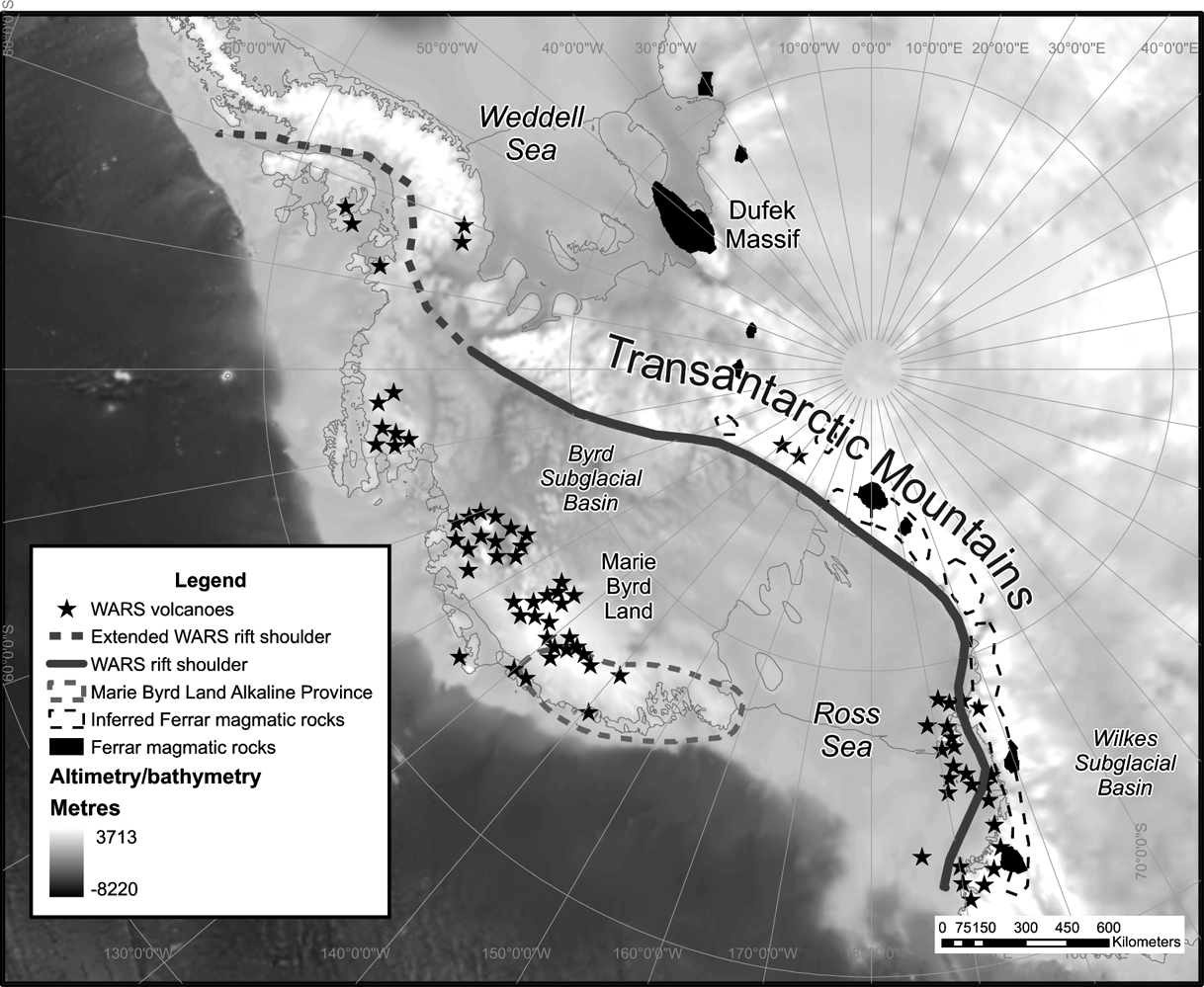
The linear outcrop pattern of the Ferrar magmatic province, sub-parallel to the proto-Pacific margin of Gondwana (Fig. 1), has led some workers (e.g. Hergt et al. Reference Hergt, Peate and Hawkesworth1991) to attribute the chemistry of the Ferrar magmas to enrichment of their mantle source material by subduction-derived fluids. For the most part, the outcrop pattern follows the subduction related Cambro–Ordovician Ross Orogen and is sub-parallel to the active Mesozoic continental margin, although geophysical data (Ferraccioli et al. Reference Ferraccioli, Coren, Bozzo, Zanolla, Gandolfi, Tabacco and Frezzotti2001) provides evidence for Ferrar magmatic rocks more than 500 km from the margin, beneath the Wilkes Subglacial Basin (Fig. 4), making a subduction-related origin less likely. Cox (Reference Cox and MacDougall1988), however, attributed the linear outcrop pattern to a similar-shaped heat source that he referred to as a “hot line”. Elliot et al. (Reference Elliot, Fleming, Kyle and Foland1999) and Storey & Kyle (Reference Storey and Kyle1997) suggested the Ferrar magmas originated from a single magmatic centre and that the present-day outcrop is the result of long distance magma transport from this point source in sills or dykes. Elliot & Fleming (Reference Elliot and Fleming2004) suggested that magma transport was ultimately controlled by an active rift system initiated in the Early Jurassic, and that the point source for the magmas was a thermal anomaly (mantle plume) at the Weddell Sea triple junction (Fig. 1) (Elliot & Fleming Reference Elliot and Fleming2000), which was also adjudged to be responsible for the Karoo low-Ti basalts of southern Africa.
Antarctic map showing the Transantarctic Mountains as the rift shoulder of the West Antarctic Rift System (WARS), the related Cenozoic alkaline magmatic province (WARS volcanoes), the outline of the Middle Jurassic Ferrar magmatic province and the outline of the mid Cretaceous alkaline magmatism in Marie Byrd Land. Extended WARS rift shoulder after Eagles et al. (1999).
1.2. Dronning Maud Land province
Magmatic rocks of the geochemically distinct Karoo magmatic province of Southern Africa are found in the once neighbouring western Dronning Maud Land sector of Antarctica (Fig. 1). Although for the most part geographically separate, Brewer et al. (Reference Brewer, Hergt, Hawkesworth, Rex, Storey, Storey, Alabaster and Pankhurst1992) identified both Karoo- and Ferrar-like rocks in the Theron Mountains of Coats Land, Antarctica (Fig. 1). In western Dronning Maud Land, Karoo magmatic activity appears to have been less intense. Flood basalt lava sequences are thinner (<1 km thickness; Luttinen & Furnes Reference Luttinen and Furnes2000) than their southern African equivalents, which are at least 1600 m in Lesotho (Marsh & Eales Reference Marsh, Eales and Erlank1984). Mafic dyke suites are also on a much smaller scale, with widths typically <2 m (Riley et al. Reference Riley, Leat, Curtis, Millar and Fazel2005). The geochemistry of the Karoo igneous rocks has been interpreted to indicate derivation from an enriched lithospheric mantle source (e.g. Erlank Reference Erlank1984) with or without crustal contamination. Others have proposed that the Karoo magmas were partial melts of a mantle plume source that were subsequently contaminated by lithospheric mantle components (Cox Reference Cox, Storey, Alabaster and Pankhurst1992; Ellam et al. Reference Ellam, Carlson and Shirley1992; Sweeney et al. Reference Sweeney, Duncan and Erlank1994).
The presence of ferropicrite and picrite dykes, together with other geochemical and isotopic evidence, indicates that the magmas comprising many of the Dronning Maud Land dykes were formed at depth (at least garnet lherzolite stability) as a result of anomalously high temperatures (>1500°C), indicative of mantle plume derivation (Riley et al. Reference Riley, Leat, Curtis, Millar and Fazel2005). Although ferropicrites may not represent a volumetrically significant magma type, the ocean island basalt (OIB)-like geochemistry and the inferred high temperatures of the ferropicritic primary melts (e.g. Gibson et al. Reference Gibson, Thompson and Dickin2000; Heinonen & Luttinen Reference Heinonen and Luttinen2008, Reference Heinonen and Luttinen2010) strongly suggest a plume source for the Karoo LIP (cf. Riley et al. Reference Riley, Leat, Curtis, Millar and Fazel2005), and contribute to the debate on the nature of hotspots and the existence of mantle plumes and their significance as sources of LIP magmatism (e.g. Foulger et al. Reference Foulger, Natland, Presnall and Anderson2005). Strongly depleted magma types are also a key component of the early Karoo intrusive (Riley et al. Reference Riley, Leat, Curtis, Millar and Fazel2005; Heinonen et al. Reference Heinonen, Carlson and Luttinen2010). Such mid-ocean ridge basalt (MORB)-like compositions (87Sr/86Sr: 0.7035, εNd: −8; Fig. 3) have been recognised from several other LIPs (e.g. Siberian Traps, Wooden et al. Reference Wooden, Czamanske, Federenko, Arndt, Chauvel, Bouse, King, Knight and Siems1993; Etendeka Province, Gibson et al. Reference Gibson, Thompson and Dickin2000) and are considered to be a key component of mantle plumes (e.g. Kerr et al. Reference Kerr, Saunders, Tarney, Berry and Hards1995). Heinonen et al. (Reference Heinonen, Carlson and Luttinen2010) suggest their findings are more concordant with a model (Coltice et al. Reference Coltice, Bertrand, Rey, Jourdan, Phillips and Ricard2009) that suggests the generation of the Karoo magmas in an extensive melting episode caused by internal heating of the upper mantle beneath the Gondwana supercontinent. On the other hand, anisotropy of magnetic susceptibility measurements indicates the presence of a regional scale radial stress system in western Dronning Maud Land, supporting a mantle plume origin for the Karoo large igneous province (Curtis et al. Reference Curtis, Riley, Owens, Leat and Duncan2008) and Heron & Lowman (Reference Heron and Lowman2011) suggest that internal heating models are not feasible.
1.3. Jurassic silicic province of Patagonia and Antarctic Peninsula
The recognition of silicic large igneous provinces in the geological record (e.g. the Etendeka–Parana (Bryan et al. Reference Bryan, Peate, Peate, Self, Jerram, Mawby, Marsh and Miller2010)) has led to the reassessment of many continental margin volcanic provinces worldwide (Bryan et al. Reference Bryan, Riley, Jerram, Stephens and Leat2002). The Chon Aike province (Fig. 1) of Patagonia extends from the Atlantic Coast to the Chilean side of the Andes (Pankhurst et al. Reference Pankhurst, Leat, Sruoga, Rapela, Márquez, Storey and Riley1998) and is correlated with the Jurassic silicic volcanic rocks of the Antarctic Peninsula (Riley & Leat Reference Riley and Leat1999; Riley et al. Reference Riley, Flowerdew, Hunter and Whitehouse2010). In eastern Patagonia, the volcanic rocks are predominantly flat lying and undeformed where they overlie crystalline basement rocks of Precambrian to earliest Jurassic age and Lower Jurassic, rift-related sedimentary rocks. In contrast, silicic volcanic rocks of the Andean Cordillera form relatively narrow outcrops, which are locally deformed, tilted and strongly affected by hydrothermal alteration. The province is dominated by phenocryst-poor ignimbrites, derived from multiple caldera centers (e.g. Aragón et al. Reference Aragón, Rodriguez and Benialgo1996; Riley & Leat Reference Riley and Leat1999), and vary in degree of welding from high grade rheomorphic ignimbrites with parataxitic textures, to the volumetrically dominant, non-welded, lithic-rich ignimbrites. Volumetrically minor rhyolite lavas, air fall, debris flow, and epiclastic deposits also occur.
The province is geochemically bimodal, but is dominated by rhyolite, with only rare examples of intermediate (basaltic andesite and/or andesite) compositions (Riley et al. Reference Riley, Leat, Kelley, Millar and Thirlwall2003a). The eruptive ages of silicic volcanic rocks from Patagonia and the Antarctic Peninsula defined by U–Pb ion microprobe dating (Pankhurst et al. Reference Pankhurst, Riley, Fanning and Kelley2000) and 40Ar/39Ar geochronology (Féraud et al. Reference Féraud, Alric, Fornari, Bertrand and Haller1999; Pankhurst et al. Reference Pankhurst, Riley, Fanning and Kelley2000) indicate that volcanism continued for as long as 30 Myr, from the Early Jurassic to Late Jurassic, but occurred in three main phases. The first phase of volcanism (188–178 Ma; V1 of Pankhurst et al. Reference Pankhurst, Riley, Fanning and Kelley2000) has a peak eruptive age of 184±2 Ma, and brackets the peak of flood basalt volcanism of the Karoo and Ferrar provinces at 183±1 Ma (e.g. Encarnación et al. Reference Encarnación, Fleming, Elliot and Eales1996). Volcanic rocks of the V1 group occur in the eastern part of the region (Marifil Formation) and at the southern Antarctic Peninsula (Mt Poster Formation, Rowley et al. Reference Rowley, Schmidt and Williams1982; Brenneke Formation, Wever & Storey Reference Wever and Storey1992). The V2 episode crops out in the central and western parts of the Chon Aike Province and widely across the north eastern Antarctic Peninsula (Mapple Formation, Riley & Leat Reference Riley and Leat1999; Riley et al. Reference Riley, Flowerdew, Hunter and Whitehouse2010). V2 has a peak eruptive age of 169±2 Ma (Pankhurst et al. Reference Pankhurst, Riley, Fanning and Kelley2000). The Tobífera Formation of southernmost Patagonia, however, yielded ages of 178 and 171 Ma (Pankhurst et al. Reference Pankhurst, Riley, Fanning and Kelley2000) and may partly span the interval between V1 and V2 (172–162 Ma). The final episode, V3 (157–153 Ma), is confined to the Andean volcanic outcrops of Argentina and Chile, although small granite bodies of this age occur both in western Patagonia and in the western Antarctic Peninsula, and maybe sub-volcanic equivalents.
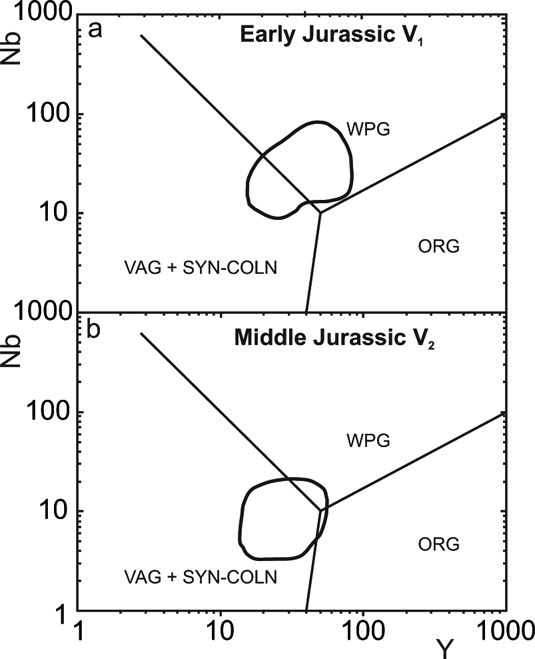
The three eruptive phases define an age progression of magmatism from an intraplate to continental margin setting, away from the locus of flood basalt volcanism in the Karoo province (Pankhurst et al. Reference Pankhurst, Riley, Fanning and Kelley2000). Concomitant with the age progression is a change in rhyolite composition from intraplate (higher Nb, Y; V1, Early Jurassic) to calc-alkaline (lower Nb, Y; V2 and V3, Middle to Late Jurassic) geochemical signatures (Fig. 5). The Early Jurassic rocks (V1) are interpreted as the partial melts of hydrous mafic crust that have mixed with fractionated components and homogenised following long term storage. The stronger within-plate signature in the V1 rocks is a result of their location distal to the continental margin, whereas the V2 and V3 rocks are closer to the Pacific margin. The Middle Jurassic silicic volcanic rocks of the Mapple Formation (Antarctic Peninsula) and those of the Chon Aike Formation (South America) are also thought to have been generated as a result of anatexis of Grenvillian age hydrous mafic lower crust of andesitic composition, linked to pre-Middle Jurassic subduction, and superimposed fractional crystallisation (Pankhurst & Rapela Reference Pankhurst and Rapela1995; Riley et al. Reference Riley, Leat, Pankhurst and Harris2001), but have much stronger subduction-modified trace element abundances (low Nb, Low Y).
Nb–Y discrimination plots for silicic rocks from the Antarctic Peninsula and Patagonia. The fields characteristic of within-plate granites (WPG), ocean ridge granites (ORG), and volcanic arc/syn-collisional granites (VAG+SYN-COLN) are those defined by Pearce et al. Reference Pearce, Harris and Tindle1984.
A Middle Jurassic (173±3 Ma) intracontinental granitic suite was identified within West Antarctica by Storey et al. (Reference Storey, Hole, Pankhurst, Millar and Vennum1988), varying in composition from A-type granites to crustal melts. The A-type granites were modelled as having being derived by closed system differentiation of a Ferrar mafic magma with varied degrees of crustal contamination. They may represent plutonic equivalents of the silicic volcanic rocks of the Chon Aike province (V2).
The fundamental reason that a large silicic province formed in southern South America, in contrast to the synchronous mafic provinces in the interior of Gondwana, was due to the presence of a fertile crustal source close to the continental margin (Bryan et al. Reference Bryan, Riley, Jerram, Stephens and Leat2002). Large degrees of crustal partial melting, essential to produce the large volumes of rhyolitic magma, are controlled by the water content and composition of the crust and the large thermal input from the mantle. Although the thermal budget for mafic and silicic large igneous provinces is considered the same (i.e. a large thermal input), hydrous crustal material is more receptive to melting, and will begin to melt at lower temperatures (Bryan et al. Reference Bryan, Riley, Jerram, Stephens and Leat2002). Ancient and active convergent margins tend to be characterised by a fertile, hydrous lower crust that can readily melt. Long-lived subduction promotes the development of a hydrated lower crust and lithospheric mantle that can extend for several hundred kilometres from the active margin (e.g., Karoo, western United States; Fitton et al. Reference Fitton, James, Kempton, Ormerod, Leeman, Menzies and Cox1988; Davis et al. Reference Davis, Elston, Hawkesworth, Prichard, Alabaster, Harris and Neary1993), particularly if significant lateral accretion has occurred over time. The silicic melts can also act as a density barrier, preventing the mafic magmas from reaching the surface (cf. Huppert & Sparks Reference Huppert and Sparks1988), as will a lack of deep, crust-penetrating structures that can transfer mafic magma to the surface.
1.4. Mid-Cretaceous alkali magmatism
Mid-Cretaceous igneous rocks of central Marie Byrd Land (Fig. 4) in Antarctica, and on the formerly neighbouring Campbell Plateau, record a rapid change from subduction-related to rift-related magmatism (Weaver et al. Reference Weaver, Storey, Pankhurst, Mukasa, DiVenere and Bradshaw1994). This correlates with the final stages of subduction of the Phoenix plate and the subsequent rifting of New Zealand from West Antarctica prior to opening of the Southern Ocean. The subduction-related igneous suite is calc-alkalic I-type diorites, granodiorites and monzogranites (108–124 Ma). Rift magmatism produced diverse A-type granitoids (monzonites, syenites, syenogranites, and alkali feldspar granites; 95 Ma to 102 Ma) and mafic plutons, dykes and sills (107±5 Ma) of continental flood basalt affinity. The mafic dyke suites have been modelled by mixing between tholeiitic asthenosphere-derived OIB with a HIMU composition and alkaline lithospheric mantle derived alkaline magmas (Storey et al. Reference Storey, Leat, Weaver, Pankhurst, Bradshaw and Kelley1999). It has been suggested that rifting was caused by changes in plate boundary forces; however, Weaver et al. (Reference Weaver, Storey, Pankhurst, Mukasa, DiVenere and Bradshaw1994) have suggested that mantle plume activity may have begun in mid-Cretaceous time, triggering melting of the lithosphere and controlling the locus of rifting. A mantle plume hypothesis is supported by evidence of 0·5–1·2 km excess topographic elevation for West Antarctica and adjacent sea floor, and by evidence of anomalously high subsidence rates on Campbell Plateau in the Palaeogene as it and New Zealand rifted away from a zone of mantle upwelling on the West Antarctic margin (Sutherland et al. Reference Sutherland, Spasojevic and Gurnis2010).
1.5. Cenozoic alkali magmatic province
A belt of Cenozoic alkaline magmatic rocks (48 Ma to presently active) lies within a broad region of extended crust known as the West Antarctic Rift System (WARS) (Fig. 4; LeMasurier Reference LeMasurier, LeMasurier and Thomson1990; Behrendt et al. Reference Behrendt, LeMasurier, Cooper, Tessensohn, Tréhu and Damaske1991). The Cenozoic extension is characterised by thin-crust approximately 20–30 km-thick, deep-rift basins within the Ross Sea region and Marie Byrd Land (Behrendt et al. Reference Behrendt, LeMasurier, Cooper, Tessensohn, Tréhu and Damaske1991) and significant uplift along the 3500 km-long, 4500 m-high Transantarctic Mountain front which separates the rift from the East Antarctic shield (ten Brink et al. Reference ten Brink, Bannister, Beaudoin and Stern1993). The West Antarctic Rift System is marked by a topographic trough 750–1000 km wide and 3000 km long, running from near the Ellsworth–Whitmore Mountains to the Ross Embayment–northern Victoria Land (Fig. 4) (LeMasurier & Thomson Reference LeMasurier and Thomson1990; Behrendt et al. Reference Behrendt, LeMasurier, Cooper, Tessensohn, Tréhu and Damaske1991, Reference Behrendt, LeMasurier, Cooper, Yoshida, Kaminuma and Shiraishi1992). The WARS is similar in size to the East African rift system and to the Basin and Range province of the western United States (Tessensohn & Wörner Reference Tessensohn, Wörner, Thomson, Crame and Thomson1991) and is geometrically asymmetric. The eastern flank in Marie Byrd Land is characterised by basin-and-range style of topography, with about 3 km of uplift in the central part (LeMasurier & Rex Reference LeMasurier and Rex1989). The opposite flank in northern Victoria Land (NVL) consists of the Transantarctic Mountains, the uplifted roots of the early Paleozoic Ross Orogen (Stump Reference Stump1995).
Eighteen major alkaline volcanoes and many smaller centres are found within the Marie Byrd Land province (Fig. 4). The volcanoes are large, mostly 3000 m in height, and are composed predominantly of felsic alkaline lavas, phonolite, trachyte, rhyolite and intermediate differentiates. Smaller basaltic centres composed of alkali basalt, basanite and hawaiite are also present and are common as parasitic vents and basal flows at the larger volcanoes. The majority of the large composite volcanoes in Marie Byrd Land are found in linear chains that become progressively younger towards the perimeter of the province. The pattern of volcanism has been explained by the sequential release of magmas from shallow chambers along a propagating relict fracture system reactivated during Cenozoic extension (LeMasurier & Rex Reference LeMasurier and Rex1989; Panter et al. Reference Panter, McIntosh and Smellie1994). In Northern Victoria Land, Cenozoic bimodal plutons with gabbroic and syenitic portions, and alkali basalt–basanite–tephrite dykes are some of oldest parts of the province, dating back to 48 Ma (Rocchi et al. Reference Rocchi, Armienti, D'Orazio, Tonarini, Wijbrans and Di Vincenzo2002). Large volcanic edifices, present in the McMurdo Sound region near Ross Island, are basaltic shield volcanoes, strato-volcanoes with dominant trachytic and phonolitic compositions, and small, isolated basaltic scoria cones and lava flows.
The alkaline basalts have similar trace-element concentrations and isotope ratios that approach the HIMU compositions of oceanic islands (Hofmann Reference Hofmann1997). The origin of the extreme HIMU signature has been attributed to recycling of ancient oceanic crust within plumes rising from the deep mantle (Hofmann & White Reference Hofmann and White1982; Hart et al. Reference Hart, Hauri, Oschmann and Whitehead1992). Geochemical studies of basalts from the West Antarctic rift support plume-related sources for volcanism (Hart et al. Reference Hart, Blusztajn and Craddock1995, Reference Hart, Blusztajn, LeMasurier, Rex, Hawkesworth and Arndt1997; Rocholl et al. Reference Rocholl, Stein, Molzahn, Hart and Worner1995). Plume models have also been used to explain tectonic doming and the spatial pattern of volcanic centres within the Marie Byrd Land province (LeMasurier & Rex Reference LeMasurier and Rex1989; Hole & LeMasurier Reference Hole and LeMasurier1994; LeMasurier & Landis Reference LeMasurier and Landis1996). Some models appeal to a single young ‘active’ plume concurrent with the onset of volcanism 28–35 Ma ago (Kyle et al. Reference Kyle, Pankhurst, Mukasa, Panter, Smellie and McIntosh1994; LeMasurier & Landis Reference LeMasurier and Landis1996), while others favour a passive model involving a ‘‘fossilised’’ plume head fixed at the base of the lithosphere (Rocholl et al. Reference Rocholl, Stein, Molzahn, Hart and Worner1995; Hart et al. Reference Hart, Blusztajn, LeMasurier, Rex, Hawkesworth and Arndt1997). In the fossil plume model, the arrival of a plume head prior to the mid-Cretaceous breakup of New Zealand from Antarctica may explain the extremely broad distribution (over 5000 km) and significant age-span (100 Ma) of HIMU-type alkaline volcanism found throughout the continental borderlands of the southwest Pacific (Lanyon et al. Reference Lanyon, Varne and Crawford1993; Hart et al. Reference Hart, Blusztajn, LeMasurier, Rex, Hawkesworth and Arndt1997; Panter et al. Reference Panter, Blusztajn, Hart and Kyle1997). Magmatism associated with either Jurassic; 184 Ma (Encarnación et al. Reference Encarnación, Fleming, Elliot and Eales1996) or Cretaceous; 100 Myr (Weaver et al. Reference Weaver, Storey, Pankhurst, Mukasa, DiVenere and Bradshaw1994) rifting events may signal early plume–lithosphere interaction. Seismic tomography (Spasojevic et al. Reference Spasojevic, Gurnis and Sutherland2010) and subsidence data (Sutherland et al. Reference Sutherland, Spasojevic and Gurnis2010) support evidence for a very long-lived deep mantle thermal anomaly off West Antarctica, probably triggered by cessation of subduction along the Gondwana margin.
Panter et al. (Reference Panter, Hart, Kyle, Blusztajn and Wilch2000) proposed a variant on the fossil plume model; one that calls upon a Cretaceous plume composed solely of the HIMU component overlain by a much more extensive pre-existing metasomatised layer within the Gondwana lithosphere. The plume-driven metasomatism may have been related to the Jurassic Bouvet-plume having enriched the Gondwana lithosphere in highly incompatible trace-elements. The plume-modified lithosphere was then underplated by a smaller HIMU-plume in mid-Cretaceous times. A Cretaceous plume-head with a diameter of 600–800 km would encompass these HIMU localities prior to continental breakup. Extension and rifting of New Zealand from Antarctica would have lead to adiabatic decompression melting of the fossil plume and overlying plume-modified lithosphere within widely dispersed fragments of the former Gondwanaland supercontinent.
Finn et al. (Reference Finn, Muller and Panter2005) reviewed the different tectonic models and concluded that the diffuse alkaline magmatic province in the south west Pacific, of which the Antarctic Cenozoic alkaline province is a part, was formed by sudden detachment and sinking of subducted slabs in the late Cretaceous that induced instabilities along the former Gondwana margin that in turn triggered lateral and vertical flow of warm Pacific mantle. According to Finn et al. (Reference Finn, Muller and Panter2005) the combination of metasomatised lithosphere underlain by mantle at slightly elevated temperatures was key to generating Cenozoic magmatism.
Alternative interpretations to both plume-driven and passive rifting have been proposed by Rocchi et al. (Reference Rocchi, Armienti, D'Orazio, Tonarini, Wijbrans and Di Vincenzo2002, Reference Rocchi, Storti, Di Vincenzo, Rossetti, Storti, Holdsworth and Salvini2003, Reference Rocchi, Di Vincenzo, Armienti, Foulger, Anderson, Natland and Presnall2005), which suggest that magma genesis and emplacement is due to the reactivation of pre-existing NW–SE translithospheric faults (Salvini et al. Reference Salvini, Brancolini, Busetti, Storti, Mazzarini and Coren1997), which promoted local decompression melting of an enriched mantle previously veined during a Late Cretaceous amagmatic extensional rift phase.
2. Links to continental break-up mechanisms
Having summarised the main features and petrogenesis of the large igneous provinces, the next section reviews the tectonic processes that may have contributed to Gondwana breakup and formation of the igneous provinces.
2.1. Plate margin processes
The parallelism of the current exposure of the Ferrar province to the active margin of Gondwana and to the Permo–Triassic Gondwanian fold belt has inevitably drawn attention to the role of plate margin processes in the initial mid Jurassic breakup of Gondwana (Storey Reference Storey1995), as has their broad calc alkaline geochemistry (Hergt et al. Reference Hergt, Chappell, Faure and Mensing1989b). Gondwana may have been pulled apart by plate boundary processes operating on either side of the supercontinent to form back arc basins and rift zones akin to the formation the Rocas Verdes in late Jurassic times (Dalziel et al. Reference Dalziel, De Wit and Palmer1974), although recent modelling suggests that this process is complex and many aspects of it are not well understood (Mikhailov et al. Reference Mikhailov, Stephenson and Diament2010; Siddoway Reference Siddoway2010; Ghosh & Holt Reference Ghosh and Holt2012). A similar plate margin model can also be used to explain the mid-Cretaceous alkaline province in Marie Byrd Land. Marine geophysical studies have shown that approaching spreading ridges stalled close to the active margin, causing the potential transfer of Marie Byrd Land to the Pacific plate and back arc rifting (Luyendyk Reference Luyendyk1995).
2.2. Thermal anomaly/mantle plume/hotspot
In 1963, Wilson (Reference Wilson1963) first suggested that the Hawaiian Islands were produced by oceanic lithosphere moving over a stationary “hot spot” in the mantle, and in 1971 Morgan (Reference Morgan1971) suggested that lower mantle plumes exist in the Earth's mantle and may play an important role in convection and continental break-up. However, there has been considerable debate recently about the existence of lower mantle plumes (Foulger et al. Reference Foulger, Natland, Presnall and Anderson2005), with a variety of thermal plumes (King & Ritsema Reference King and Ritsema2000; Davies & Bunge Reference Davies and Bunge2006; Wilson & Downes Reference Wilson, Downes, Gee and Stephenson2006) having been described as focused vertical upwellings that are not directly rooted in the lower mantle, as predicted by the original hotspot model (Morgan Reference Morgan1971). Moreover, high-resolution seismological images have shown many apparent small-scale convective heterogeneities in the uppermost mantle at margins such as the western US (e.g. Sigloch et al. Reference Sigloch, McQuarrie and Nolet2008; West et al. Reference West, Fouch, Roth and Elkins-Tanton2009) and the Mediterranean (Faccenna & Becker Reference Faccenna, Becker, Lallemandc, Lagabriellec, Funiciellod and Piromallo2010). Subcontinental small-scale convection may be initiated by sharp temperature gradients at a craton's edge, where decompression melting may cause volcanism (King & Anderson Reference King and Anderson1995). An indirect connection to slab return flow, which may interact with a hydrated layer in the transition zone to facilitate localised upwellings along active plate margins, has also been suggested (Leahy & Bercovici Reference Leahy and Bercovici2007; Faccenna et al. Reference Faccenna and Becker2010; Rey & Mueller Reference Rey and Mueller2010).
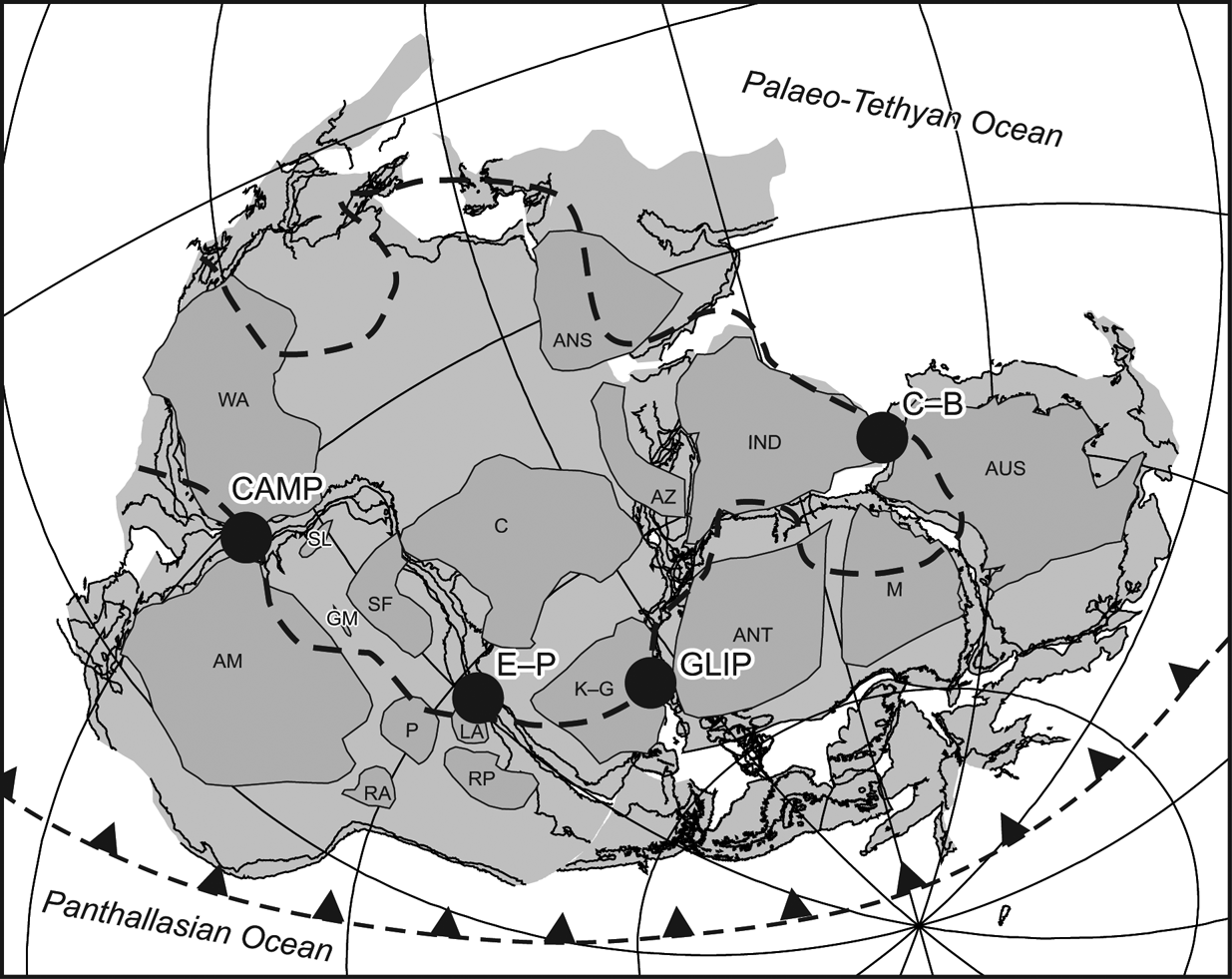
However, in addition to indications from geoid anomalies, the presence of long-lived thermal anomalies in the mantle has been demonstrated by seismic velocity distribution models based on tomographic techniques using both P- and S-waves (e.g. van der Hilst et al. Reference van der Hilst, Widiyantoro and Engdahl1997; Montelli et al. Reference Montelli, Nolet, Dahlen, Masters, Engdahl and Hung2004; Reference Montelli, Nolet, Dahlen and Masters2006; Steinberger & Torsvik Reference Steinberger and Torsvik2012). Large, low-velocity seismic anomalies have been detected in the Earth's lower mantle at the core–mantle boundary beneath Africa and the Pacific Ocean, with the chemically distinct sub-Pacific and sub-African large low shear velocity provinces (LLSVPs) becoming a robust feature (Fig. 6) (Wang & Wen Reference Wang and Wen2004; Steinberger & Torsvik Reference Steinberger and Torsvik2012). Density heterogeneities, imaged using seismic tomography, contain information about time-dependent mantle flow and mantle structure that existed in the past (Torsvik et al. Reference Torsvik, Smethurst, Burke and Steinberger2008). During the Mesozoic, an associated modelled topographic high is situated near Gondwana rifting, raising the possibility that this buoyant structure may have been involved with Gondwana breakup (Conrad & Gurnis Reference Conrad and Gurnis2003). Burke et al. (Reference Burke, Steinberger, Torsvik and Smethurst2008) have shown that LIP eruption sites of the past 300 m.y. lie vertically above the horizontal edges of the African and Pacific LLSVPs at the core-mantle boundary, and this spatial association is demonstrated for Gondwana break-up LIPs in Figure 6. Near the core–mantle boundary, the association of the high temperature of the outer core with an inclined thermal boundary layer at the margins of LLSVPs facilitates the generation of mantle plumes in the plume generation zones (Tronnes Reference Tronnes2010). Seismic tomography studies associated with examination of large low shear velocity provinces also indicate that whole mantle convection is occurring beneath the Pacific Ocean (Schmerr et al. Reference Schmerr, Garnero and McNamara2010; Liu et al. Reference Liu, Tan, Sun, Chen and Helmberger2011), making non-plume models significantly less tenable.
Gondwana reconstruction for 180 Ma (modified after Pankhurst & Vaughan Reference Pankhurst, Vaughan and Bassett2009) showing major cratons and projected outline of the African LLSVP (heavy dashed line) from Torsvik et al. Reference Torsvik, Burke, Steinberger, Webb and Ashwall2010. Major post-Permian large igneous province centres associated with the break-up of Gondwana are marked: CAMP=Central Atlantic Magmatic Province, 200 Ma (after Marzoli et al. Reference Marzoli, Renne, Piccirillo, Ernesto, Bellieni and De Min1999); GLIP=Gondwana Large Igneous Province, 180 Ma (after Storey & Kyle Reference Storey and Kyle1997); C–B=Comei–Bunbury LIP, 134 Ma (after Zhu et al. Reference Zhu, Chung, Mo, Zhao, Niu, Song and Yang2009); E–P=Etendeka–Paraná, 132 Ma (after Peate Reference Peate, Mahoney and Coffin1997). Craton labels are after Pankhurst & Vaughan Reference Pankhurst, Vaughan and Bassett2009, as follows: AM=Amazonia; ANS=Arabian–Nubian Shield; ANT=Antarctica; AUS=Australian cratons; AZ=Azania; C=Congo; GM=Goias Massif; IND=Indian cratons; K–G=Kalahari–Grunehogna; LA=Luis Alves; M=Mawson; P=Paraná; RA=Rio Apa; RP=Rio de la Plata; SF=Sao Francisco; SL=San Luis; WA=West Africa.
Ideas vary on the role of mantle plumes in continental breakup, from the original active mantle hypothesis of Morgan (Reference Morgan1971, Reference Morgan and Emiliani1981), who considered that plumes drive the plates and initiate continental breakup by doming and cracking the continents and pushing the continents apart, to passive models, where the plume plays no part in breakup except that the chance unroofing of a pre-existing or incubating plume results in rapid outpouring of flood basalt provinces (White & McKenzie Reference White and McKenzie1989). Some hybrid models combine aspects of both passive and active models; the forces that drive plate motions place the continents under tension when subduction is taking place on both sides of the continent, but it is the arrival of a new plume that weakens them and causes them to split and form a new ocean (Hill Reference Hill1991; Bott Reference Bott, Storey, Alabaster and Pankhurst1992; White Reference White, Storey, Alabaster and Pankhurst1992). With the initial breakup of Gondwana, many authors suggested that one or more centres of thermal activity responsible for the three Middle Jurassic igneous provinces (Karoo, Ferrar and Chon Aike) were situated in the Weddell Sea sector between South America, southern Africa and Antarctica (Storey & Kyle Reference Storey and Kyle1997; Elliott & Fleming Reference Elliot and Fleming2000; Ferris et al. Reference Ferris, Vaughan and Storey2000, Reference Ferris, Storey, Vaughan, Kyle and Jones2003; Storey et al. Reference Storey, Leat, Ferris, Ernst and Buchan2001). The thermal anomalies may have been responsible for Gondwana breakup by doming of the lithosphere and gravitational collapse, leading to continental rifting (active rifting model; Storey & Kyle Reference Storey and Kyle1997). Storey et al. (Reference Storey, Leat, Ferris, Ernst and Buchan2001) also suggested that within a regional anomaly or superplume, three hotspots may have existed: beneath the Mozambique Basin (Discovery hotspot); beneath the Weddell Sea embayment region (Shona hotspot); and beneath the Dufek intrusion in the Pensacola Mountains (Bouvet hotspot). If the Weddell Sea region was the centre of magmatic activity at the time of breakup, then, in the case of the Ferrar province, magma would have been transported through dyke or sill complexes for distances in excess of 3000 km (Fig. 1).
Another intriguing aspect of the geological evolution of the Weddell Sea–South Atlantic region in the Middle Jurassic was the formation of rotated microplates (Dalziel & Elliot Reference Dalziel and Elliot1982; Mitchell et al. Reference Mitchell, Taylor, Cox and Shaw1986). An Ellsworth microplate, formed at the time of breakup, rotated clockwise more than 90° and migrated from an original position between South Africa and Antarctica to its present position at the head of the Weddell Sea (Schopf Reference Schopf1969; Grunow et al. Reference Grunow, Kent and Dalziel1987). The Falkland Islands, like the Ellsworth Mountains, rotated 180° from a similar position between African and Antarctica to join South America on the opposite side of the Atlantic. We cannot be sure exactly how and why these microplates and rotations occurred, or why Gondwana should have broken up in this way, but it has been suggested that they were in some way linked to the formation of the volcanic province at the start of rifting and the presence of a thermal anomaly or anomalies beneath the Weddell Sea sector of Gondwana, with the microplates forming on a thermal dome of the lithosphere and rotating to their present positions during sea floor spreading (Storey Reference Storey1995; Storey et al. Reference Storey, Leat, Ferris, Ernst and Buchan2001). Martin (Reference Martin2007) provides an alternative explanation for Gondwana breakup via what he terms double-saloon-door rifting and seafloor spreading in a backarc basin during subduction rollback.
Interestingly, displaced microplates are also a significant component of the final separation of South America from the Antarctic Peninsula and the opening of Drake Passage in the Scotia Sea region: the South Georgia block has moved from a position much closer to southern South America to its present position; the South Orkney block separated from the northern tip of the peninsula to form the Powell Basin; and the South Shetland Islands has separated from the peninsula by sea floor spreading in Bransfield Strait. Although the driving mechanisms may not always be the same, the history of rotated microplates has been repeated in the South Atlantic region and raises intriguing questions about breakup processes.
2.3. Plume capture
Various other models involving mantle plumes have also been produced, most notably a plume capture model (Dalziel et al. Reference Dalziel, Lawver and Murphy2000) where a mantle plume located beneath oceanic lithosphere was subducted along the active margin of Gondwana in the Permo–Triassic forming the Gondwanian fold belt, heating the Gondwana continental lithosphere, ultimately leading to rifting, emplacement of LIPs and sea floor spreading. This model for the first time successfully linked the Gondwanian fold belt with the locus of rifting and the formation of the LIPs of the Karoo. It is based on a long-lived mantle plume derived from a deep-seated thermal anomaly in the mantle, unrelated to the insulation of continental lithosphere.
2.4. Supercontinental cycles
There is a growing consensus that supercontinent assembly and breakup is a self-organising process (e.g. Vaughan & Storey Reference Vaughan and Storey2007; Gutierrez-Alonso et al. Reference Gutierrez-Alonso, Fernandez-Suarez, Weil, Murphy, Nance, Corfu and Johnston2008), largely driven by the expansion and contraction of convection cell systems in the upper mantle as their thermal evolution interacts with an overlying supercontinent and its surrounding ocean (e.g. Yoshida & Santosh Reference Yoshida and Santosh2011), or triggers deep-sourced mantle plumes (e.g. Vaughan & Storey Reference Vaughan and Storey2007). Various models exist for modification and evolution of upper mantle convection as a result of thermal insulation by thick continental lithosphere (Anderson Reference Anderson1982; Trubitsyn et al. Reference Trubitsyn, Mooney and Abbott2003; Heron & Lowman Reference Heron and Lowman2010), which can ultimately drive supercontinent fragmentation. However, recent modelling studies (Heron & Lowman Reference Heron and Lowman2011) indicate that supercontinent evolution is insufficient to change upper mantle temperatures on the timescale of supercontinent assembly, and that large subcontinental mantle plumes develop as a result of subduction patterns rather than thermal insulation by supercontinents. Modelling of large low shear velocity provinces also confirms this result (Tan et al. Reference Tan, Leng, Zhong and Gurnis2011). Although the original thermal blanketing idea of Anderson (Reference Anderson1982) was conceived prior to mantle plume theories of continental break-up (e.g. White & McKenzie Reference White and McKenzie1989; Storey Reference Storey1995), it has been reconciled in part with mantle plume-related mechanisms by Condie et al. (Reference Condie, Abbott and Des Marais2002) and Condie (Reference Condie2004) via a form of the superplume event concept of Larson (Reference Larson1991a, Reference Larsonb; Condie et al. Reference Condie, Marais and Abbott2001). Convection-based models can also explain supercontinent creation by providing a convergent force, driven by large scale down-flow driven by subduction that draws continental fragments together (e.g. Yoshida & Santosh Reference Yoshida and Santosh2011).
Despite the focus on upper mantle processes as the main driver for the supercontinent cycle, geological evidence suggests that lower mantle processes, hot rising plumes from the core-mantle boundary in particular, are also important (e.g. Vaughan & Livermore Reference Vaughan, Livermore, Vaughan, Leat and Pankhurst2005). Upper mantle convection-driven models indicate that supercontinent formation should occur by process of “extroversion” (Murphy et al. Reference Murphy, Nance and Cawood2009). “Extroversion” is a process of supercontinent formation that conforms to models of thermal insulation of the mantle beneath a supercontinent changing upper mantle convection (e.g. Trubitsyn et al. 2003) and driving initial supercontinent fragmentation and formation of a young internal ocean. Supercontinent fragmentation and breakup then proceeds by expansion of the internal ocean and subduction of the thermally older and colder external ocean, ultimately resulting in the formation of a new supercontinent as this ocean closes (Murphy et al. Reference Murphy, Nance and Cawood2009). In the process of “extroversion” supercontinents turn themselves inside out (Murphy & Nance Reference Murphy and Nance2005).
Gondwana breakup conforms to the “extroversion” model, with the supercontinent breaking up by formation of young internal oceans, such as the Indian and South Atlantic oceans, and consumption of exterior oceans, such as neo-Tethys or the Pacific Ocean outboard of New Zealand. The involvement of deep-sourced mantle heat in the breakup of Gondwana remains a subject of discussion (e.g. Eagles & Konig Reference Eagles and Konig2008; Heinonen et al. Reference Heinonen, Carlson and Luttinen2010), although the demonstrated coincidence between the centres of Gondwana large igneous provinces and the margins of the African LLSVP (Fig. 6) argues strongly in favour of it. Geological evidence indicates that mantle plumes were responsible for the large volumes of basaltic and silicic magmatism that erupted during the onset of breakup (e.g. Riley et al. Reference Riley, Leat, Storey, Parkinson and Millar2003b). Recent plate kinematic analyses, however, suggest that breakup may not have been totally dependent on mantle plumes (Eagles & Konig Reference Eagles and Konig2008; Eagles & Vaughan Reference Eagles and Vaughan2009).
3. Environmental impacts
Increasing evidence links the formation of large igneous provinces with climate change, environmental effects and extinction events throughout the Phanerozoic (Wignall Reference Wignall2001, Reference Wignall and Saunders2005). In general, LIP eruptions are temporally associated with some or all of the following climatic/environmental effects: phases of rapid global warming/cooling; changes in pCO2 and other atmospheric trace gases (CH4, SO2, halogens); changes in the hydrological cycle; sea-level change (Wignall & Bond Reference Wignall and Bond2008); oceanic anoxia and/or increased oceanic fertilisation; calcification crises; mass extinction/evolutionary radiations; and release of gas hydrates (as interpreted from rapid negative shifts of δ13C). Although many mechanisms have been proposed to explain these associations, no simple relationship has yet been identified. However, Sobolev et al. (Reference Sobolev, Sobolev, Kuzmin, Krivolutskaya, Petrunin, Arndt, Radko and Vasiliev2011) have demonstrated a strong relationship between the lethality of a LIP and the volume of recycled oceanic crust in the plume head.
Superplume events (Larson Reference Larson1991a) cause fundamental reorganisations of Earth surface processes, inferred to be triggered by changes in mantle convection. They are multi-million-year periods characterised by globally high sea levels, increased sea-floor spreading rate, plate reorganisation, eruption of >100,000 km2 basalt plateaux, and reduced reversal rate frequency of the geomagnetic field (in some cases creating so-called magnetically “quiet zones” in oceanic crust). Superplumes are associated with elevated levels of atmospheric carbon dioxide, increased temperature and major perturbations of the global carbon cycle, with deposition of huge accumulations of carbon-rich sediments (e.g. chalk, coal, oil source rocks) (Reference LarsonLarson 1991b). In the case of the best-known superplume event, which happened in the mid-Cretaceous (∼120–80 million years ago), the range of effects also includes: ocean margin deformation (Vaughan Reference Vaughan1995; Vaughan & Livermore Reference Vaughan, Livermore, Vaughan, Leat and Pankhurst2005); widespread emplacement of diamondiferous kimberlites (Larson & Kincaid Reference Larson and Kincaid1996; Haggerty Reference Haggerty1999); marine anoxia (e.g. Larson & Erba Reference Larson and Erba1999); and a substantial evolutionary radiation of both marine and terrestrial taxa (Vermeij 1995; Benton Reference Benton1996; Lupia Reference Lupia1999; Leckie et al. Reference Leckie, Bralower and Cashman2002).
The link between the Karoo–Ferrar eruptions and contemporaneous environmental and climatic changes is well established. Good radiometric dates indicate that the eruptions began in the early Toarcian Stage of the Early Jurassic (Pálfy & Smith Reference Pálfy and Smith2000). This coincides with a well-documented, oceanic anoxic event, a warming trend, a calcification crisis in equatorial latitudes and marine mass extinction (Wignall Reference Wignall2001; Erba Reference Erba2004). Examination of carbon isotopes in wood from this time indicate major carbon isotope perturbations, including a sharp negative excursion roughly coincident with the onset of ocean anoxia that is interpreted as the product of a catastrophic release of methane from gas hydrate reservoirs from marine continental margin reservoirs (Hesselbo et al. Reference Hesselbo, Grocke, Jenkyns, Bjerrum, Farrimond, Bell and Green2000; Beerling & Royer Reference Beerling and Royer2002; Jenkyns Reference Jenkyns2003). At the peak warming, the increase of continental weathering rates, probably associated with a change in the hydrological cycle, appears to have been reflected by a decline in 187Os/188Os ratios (Cohen et al. Reference Cohen, Coe, Harding and Schwark2004). The environmental changes are generally connected to volcanic CO2 emissions. CO2 levels and, probably atmospheric temperatures, were also substantially elevated across the boundaries of the Triassic–Jurassic (Beerling & Royer Reference Beerling and Royer2002) and Pliensbachian–Toarcian (Hesselbo et al. Reference Hesselbo, Grocke, Jenkyns, Bjerrum, Farrimond, Bell and Green2000), and also in the early Middle Jurassic (174–170 Ma: Hesselbo et al. Reference Hesselbo, Morgans-Bell, McElwain, Rees, Robinson and Ross2003). Stable isotope analyses of pedogenic carbonates interbedded with the Triassic–Jurassic Central Atlantic Magmatic Province lavas in the Newark Basin show a doubling of pCO to from 2000 ppm to 4400 ppm immediately after the first volcanic unit, with a steady decrease towards pre-eruptive levels over the subsequent 300,000 years (Schaller et al. Reference Schaller, Wright and Kent2011). This pattern is also observed following the second and third flow units, providing strong support for direct perturbation of atmospheric CO2 levels by large igneous province related volcanism.
The mid-Cretaceous, the time of emplacement of the Marie Byrd Land igneous province (Cenomanian–Turonian, C–T boundary) is marked by the type example of the Cretaceous oceanic anoxic events, the culmination of Cretaceous greenhouse warming (and sea-level rise), and a minor extinction event in the marine fossil record (Hallam & Wignall Reference Hallam and Wignall1999; Jenkyns Reference Jenkyns1999). It thus has many of the hallmarks of other volcanogenic events, although evidence for gas hydrate release is lacking and there is only weak evidence for a calcification crisis (Erba Reference Erba2004). All of these events essentially coincide with the eruption of the main phase of the Caribbean–Colombian LIP and part of the Kerguelen LIP, and the Madagascan flood basalts (Kerr Reference Kerr1998; Courtillot & Renne Reference Courtillot and Renne2003). The oceanic anoxic event OAE 2 itself provides the most obvious cause of the marine extinctions, and the contribution of volcanism to global warming and fertilisation of the oceans provides a route to link volcanism and extinctions (Sinton & Duncan Reference Sinton and Duncan1997). Both warming (directly by the oceanic lavas) and possible oceanic acidification would have released CO2 to the atmosphere, thus exacerbating an already established trend of global warming (Kerr Reference Kerr1998, Reference Kerr2005).
The preponderance of evidence for warming strongly suggests that volcanic carbon dioxide emissions were responsible for the initial environmental changes, with knock-on effects that include the release of gas hydrates, acidification of ocean surface waters and elevation of the oceanic calcite compensation depth (CCD). There is also growing evidence that abundant carbonatites are released with LIPs (Ernst & Bell Reference Ernst and Bell2010), providing a mantle source of CO2. The volcanic CO2 eruptions may also have served as a trigger for events such as the release of methane from clathrates. However, the evidence for methane release (the rapid negative shifts of δ13C) is seen much less frequently than the evidence for warming. It appears LIP formation can cause changes that range from the relatively benign (Palaeocene–Eocene boundary), to severely damaging (Toarcian) to utterly catastrophic (end-Permian). Factors such as the degree of explosive magmatism (Elliot & Hanson Reference Elliot and Hanson2001; Ross et al. Reference Ross, Peate, McClintock, Xu, Skilling, White and Houghton2005), whether or not large igneous provinces are erupted on the continent or in submarine settings, pre-eruption atmospheric CO2 levels, the proportion of recycled oceanic crust in the plume head (Sobolev et al. Reference Sobolev, Sobolev, Kuzmin, Krivolutskaya, Petrunin, Arndt, Radko and Vasiliev2011), and the rate of eruption, may turn out to be key variables in any environmental changes resulting from volcanic eruptions.
4. Concluding remarks
It is very unlikely that a single model can explain the igneous provinces in the Mesozoic and Cenozoic history of Antarctica. However, there seems little doubt, based on the presence of ferropicrites in Dronning Maud Land (DML) and the recent discovery of LLSVPs, that a thermal anomaly was responsible for the DML–Karoo large igneous province, and early Cretaceous large igneous provinces associated with Gondwana breakup. The debate as to whether the anomaly was due to the insulating effect of Gondwana or due to a deep seated mantle plume has largely been resolved by the discovery of LLSVPs, and the evidence they provide for a fixed long-term source for deep seated mantle plumes. The origin of the Ferrar igneous province remains an unresolved issue. It appears likely that the Weddell Sea region, with its volcanic rifted margins, was an important centre of magmatic activity, splitting the Karoo province into an African and Antarctic DML section. However, whether the magmas could have migrated the large distances involved to form the Ferrar province is unproven. A rift along the length of the Transantarctic Mountains driven by changes in plate boundary forces may provide a less dramatic but more compelling case. Similarly, for the Cretaceous Marie Byrd Land province, a link to subduction processes is hard to avoid, although involving the generation of hot rising plumes (Spasojevic et al. Reference Spasojevic, Gurnis and Sutherland2010). It is also possible that large igneous provinces close to active continental margins may have formed by an indirect connection to slab return flow, which may interact with a hydrated layer in the transition zone to facilitate localised upwellings along active plate margins (Faccenna et al. Reference Faccenna and Becker2010).
Whatever processes controlled or influenced the breakup of Gondwana, the supercontinent separated into the major continents as we know them today, together with rotated microplates in the Weddell Sea region. We cannot be sure exactly how and why these microplates and rotations occurred, or why Gondwana should have broken up in this way, but it may in some way have been linked to the formation of the volcanic provinces at the start of rifting and the presence of a thermal anomaly beneath the Weddell Sea sector of Gondwana, with the microplates forming on a thermal dome of the lithosphere and rotating to their present positions. The trajectory, displacement history and rotation mechanisms of the micro plate component of the Gondwana jigsaw remains a mystery. As is often the case, more than one driver may ultimately be responsible for the disintegration of Gondwana. That some of these processes may be linked in a supercontinent model is also entirely feasible. However, at the present time, the evidence is leaning strongly in favour of a deep mantle origin for hot plumes as the source of the bulk of large igneous province magmatism. Periodic emplacement of LIPs during the Earth's history also coincided with, and possibly had a profound effect on, the environmental and climatic conditions throughout the Earth's history.
5. Acknowledgements
We are very grateful to the ISAES organisers for supporting and providing the opportunity to present this review. We are also very grateful to our numerous colleagues that we have worked with on this topic over the years and to the reviewers (Stephen Self, Andrew Kerr and Kathryn Goodenough) for their thorough and detailed reviews that have much improved the manuscript.