




No CrossRef data available.
Article contents
- Abstract
- COPAN VALLEY BACKGROUND
- DEFINING THE SCALES OF COPAN RURAL SOCIAL STRUCTURE AND INTERACTION: HOUSEHOLD—COMMUNITY—ELITE
- RURAL COPAN HOUSEHOLD STRUCTURE
- RURAL COPAN COMMUNITY STRUCTURE
- THE DYNAMIC PROCESS OF RURAL COMMUNITY FORMATION
- ARCHAEOLOGICAL IMPLICATIONS OF THE COPAN ANCIENT SIAN OTOT MODEL
- RESUMEN
- ACKNOWLEDGMENTS
- References
MULTISCALAR MODEL OF RURAL HOUSEHOLDS AND COMMUNITIES IN LATE CLASSIC COPAN MAYA SOCIETY
Published online by Cambridge University Press: 01 January 2004
Article contents
- Abstract
- COPAN VALLEY BACKGROUND
- DEFINING THE SCALES OF COPAN RURAL SOCIAL STRUCTURE AND INTERACTION: HOUSEHOLD—COMMUNITY—ELITE
- RURAL COPAN HOUSEHOLD STRUCTURE
- RURAL COPAN COMMUNITY STRUCTURE
- THE DYNAMIC PROCESS OF RURAL COMMUNITY FORMATION
- ARCHAEOLOGICAL IMPLICATIONS OF THE COPAN ANCIENT SIAN OTOT MODEL
- RESUMEN
- ACKNOWLEDGMENTS
- References
Abstract
A variety of models contribute to our understanding of Classic Maya sociopolitical structure. Few, however, consider the variability that existed within Maya systems, and the temporal and spatial scales of analysis have often been limited, especially with respect to the commoner segment of society. One model that has focused attention on this component of the Maya is the sian otot, described by Charles Wisdom (1940 The Chorti Indians of Guatemala. University of Chicago Press) and introduced for the Copan Maya by William Fash (1983 Deducing Social Organization from Classic Maya Settlement Patterns: A Case Study from the Copan Valley. In Civilization in the Ancient Americas: Essays in Honor of Gordon R. Willey. University of New Mexico Press and Peabody Museum of Archaeology and Ethnology, Harvard University). Based on data from a 135-km2 regional settlement survey and excavations of the Copan Valley in Honduras, it is argued that this model, in conjunction with other, broader models of Classic Maya society, offers a useful perspective from which to construct a multiscalar model of ancient Copan social organization. The variability among sian otot, particularly in terms of economic production, is considered. The ceramic data from Copan suggest that ceramic production among commoner units was communal, and the possibility for community cooperatives is raised. Finally, the dynamic scale and productive relations among the commoners are considered in light of broader sociopolitical changes in the processual history of the Copan polity. It is concluded that the intersection of social, political, and economic institutional frameworks needs to be more comprehensively investigated from varied scales, both temporal and settlement, to appreciate fully the diversity of Maya social organization during the Late Classic/Terminal Classic transition.
Information
- Type
- SPECIAL SECTION: NEW PERSPECTIVES ON ANCIENT LOWLAND MAYA SOCIAL ORGANIZATION
- Information
- Copyright
- © 2004 Cambridge University Press
At the most general, it is possible that a theory of change in household organization can bridge the existing “mid-level theory gap” in archaeology. We are all familiar with the distance between grand theories of culture change and evolution and the practical archaeology of potsherds and stone tools. Though we try to jump the gap between ceramic types and theories of the rise of the state, our leaps lack credibility because there are no connecting models or postulates. (Wilk and Rathje 1982:617)
As a metaphor, we often speak of a “social fabric” to illustrate the complexity of social connections in a society. Following this metaphor, different fabrics have different properties based on their woven structure. Plain weave, the simple over–under of warp and weft thread, has the greatest number of intersections between the warp and weft; thus, it creates a very stable, durable fabric but lacks flexibility. A twill weave, whose weft threads float over two or more warps, has less than half the number of intersections, resulting in significantly greater flexibility—why twills are often employed in trousers. More elaborate woven structures such as overshot or damask used as table linens or bedspreads produce intricate but fragile fabrics since their threads are woven with fewer and more irregular intersections. Consequently, the same warp and weft can produce a wide variety of fabric types simply based on their weave or the pattern of their intersections.
Following the intellectual impetus of Emile Durkheim (1933) and Morton Fried (1967), Maya archaeologists reconstruct social interconnections—the “social fabric”—among the economic, political, religious, and social segments of ancient Maya society. The goal is to define better the structure of basic social units—families, households, and communities—as well as the articulation of various social, economic, religious and political institutional frameworks through the evolutionary history of Maya society. This type of research has traditionally presented challenges because of the various levels of scale—temporal, spatial, and social—which must be bridged and integrated. Accordingly, research questions have often been scale-specific, and many debates in Maya archaeology have been generated by sliding between various scales without their explicit recognition. Emilio Moran (1990) noted the same concern with Amazonian research. We require a multiscalar model that explicitly considers Maya social organization holistically as a process within various levels rather than as a single static entity.
To do so, the first task is to define the significant social units or levels in ancient Maya society. Ethnologists view the household as the fundamental social unit, although their definition of household has changed significantly. It was first viewed as an economically cooperative, socially related group of people living under the same roof who interacted on a daily basis (Wilk and Rathje 1982). This definition, however, was not confirmed cross-culturally (Bender 1967; Goody 1972), leading to the distinction between dwelling units (roofed-over residences) and households (a unit of daily social and economic cooperation [Wilk and Rathje 1982]). Thus, a household can occupy several buildings, such as a plaza group, with its occupants acting as a single economic and social unit in daily activities. Conversely, several households can occupy a single roofed-over space but behaviorally operate as separate social and economic units. Archaeologists excavate the material remains of dwellings, not households (Wilk and Rathje 1982), yet it is the behavioral aspects of households and their larger social embeddedness that are the basic foundation of many theories of interest to archaeologists.
Complicating the issue of scale further is the fact that households are adaptive units—what Richard Adams (1981) termed “survival vehicles.” Thus, households have their specific developmental histories while their structure also evolves over time as part of the broader process of sociopolitical evolution. Consequently, this foundational unit of society is fluid demographically, spatially, functionally, symbolically, and temporally. A Maya household at a.d. 500 functioned differently in many ways from occupants of the same dwelling unit (site) at a.d. 750, just as its occupants responded to various tasks differently at distinct episodes within a single household's development cycle (Wilk 1989). Obviously, this problem is intensified by internal socioeconomic differences in class and wealth, geographic differences over settlement regions, and ecological changes in resource availability. This is precisely why households are of central concern to archaeologists, particularly in regard to their material linkages.
Recently, economic and feminist anthropologists also have debated the household's role as a homogenous social unit, especially as it relates to the organization of domestic labor (Hendon 1996). As Sarah Milledge Nelson (1997) observed, reexaminations of the public–private dichotomy have demonstrated the limitations of this dichotomy to understanding domestic labor divisions. Essentialist biological explanations for gendered divisions of labor have been critically examined and found to be culturally unsupported. The assumed homogenization of domestic gender roles has been questioned, and the recognition of gender neutral roles and household gender role variability has been acknowledged (Nelson 1997). Emerging from this research is the growing consensus that domestic relations are extremely dynamic (Brumfiel 1994; Halperin 1988; Wilk and Ashmore 1988) and that it is critical to “emphasize the importance of activities and their culturally constructed meaning, rather than kinship norms or family composition in defining the household” (Hendon 1996:46).
Despite the growth in household archaeology, few projects have produced the depth and breadth of data necessary to take studies to the next logical level of analysis: the regional household network. Central to this research is the need to reconstruct the larger economic linkages among households; the levels and scale of cooperative labor that existed to form rural communities; and the rate, means and form of sociopolitical change that influenced the interaction between these economic communities and the elite. One site with perhaps the richest database for investigating the linkages between all these research facets is Copan, Honduras, which has enjoyed a series of intensive research projects conducted by a wide range of scholars using a variety of theoretical and methodological approaches.
COPAN VALLEY BACKGROUND
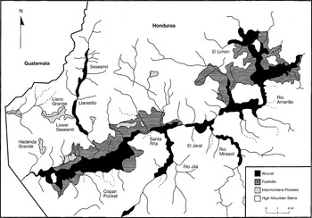
Copan is the largest archaeological center of the Maya southeast periphery, situated 14 km east of the Guatemalan border in Honduras. The Copan Valley river drainage spans an area of roughly 400 km2 and contains four small tributary rivers at whose confluences pockets, or bolsas, of alluvial land have formed. The predominant alluvial area is the Copan Pocket, extending 12 km long and 2–4 km wide (Figure 1). Enclosing the river-valley alluvium are gently sloping foothills that rise steeply to mountains peppered by small intermontane valleys. Consequently, the physiographic setting of the Copan Valley is dissimilar to the majority of lowland Maya center locales, and this had a significant impact on the formation of ancient Copan communities, which tended to form within these well-defined, constricted pockets of alluvium.

Copan Valley ecological zones (modified from Freter 1994:161, Figure 74).
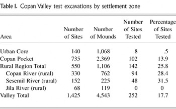
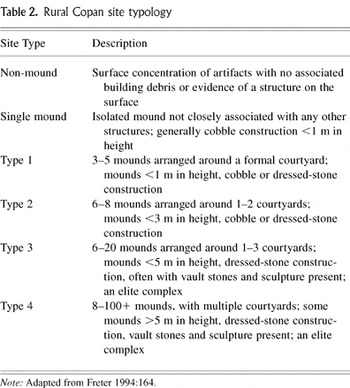
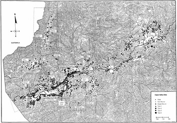
Modern archaeological research at Copan began with the invitation by J. Adan Cueva (then the director of the Instituto Hondureño de Antropología e Historia) to Gordon Willey (of Harvard University) to conduct a preliminary survey of the Copan Valley and define a course of future archaeological research. This resulted in the Peabody Museum Copan expedition conducted from 1975 to 1977 (Willey and Leventhal 1979; Willey et al. 1994). The survey and excavation focused on the urban core settlement zone, including the Copan Main Group (Figure 2). This research was followed from 1977 to 1984 by the Proyecto Arqueologico Copan (PAC), first directed by Claude Baudez from 1977 to 1980 (PAC I) and then by William T. Sanders and David Webster from 1980 to 1984 (PAC II). In conjunction with PAC II, a rural sustaining area settlement survey was funded by the National Science Foundation, designed to extend the previous settlement work conducted in the valley (Freter 1992, 1994; Webster et al. 2000). By 1990, the combined efforts of these projects had collectively mapped a 135-km2 area of the Copan Valley, locating 1,425 sites consisting of 4,543 mounds (Figure 2). In conjunction with the PAC II rural survey, a comprehensive test excavation program was conducted from 1983 to 1989, during which a 25.8% stratified random sample of sites in the rural region and a 13.9% stratified random sample of sites in the Copan Pocket settlement zones were test excavated, yielding a 17.7% excavated sample of the total settlement universe (Table 1). The sites selected for test excavations were stratified on the basis of geographic area (aerial photograph quadrant) and site type, following a modified version of the Willey and Leventhal (1979) Copan site-classification system (Table 2) to secure a statistically representative sample from all geographic areas and social levels (Freter 1992). In addition, a comprehensive chronology project was undertaken in conjunction with the settlement test excavations that combined radiocarbon dates, archaeomagnetic dates, and more than 2,000 obsidian-hydration dates to form a highly detailed chronological framework from which to understand the dynamics of this settlement system (Freter 1992; Webster and Freter 1990; Webster et al. 2000).
Copan Valley test excavations by settlement zone

Rural Copan site typology


Copan Valley site distribution in relation to topography.
One of the results of this extensive field and laboratory research was the definition of three distinct prehistoric settlement zones within the Copan Valley. Most densely occupied (with 1,425 structures/km2) is the Urban Core, a 0.75-km2 (75-ha) area that includes the Copan Main Group and its two flanking barrios, El Bosque and Las Sepulturas. The Copan Pocket area, a 24-km2 area surrounding the Urban Core, contains a moderate settlement density (102 structures/km2), and the Rural Region outside the Copan Pocket contains the lightest settlement density (10 structures/km2).
The Copan settlement data are complemented by data from 16 extensively excavated residential sites representing a cross-section of Late Classic Copan society from the ruling elite (Andrews V and Fash 1992) to the nobility (Ashmore 1991; Diamanti 1991; Hendon 1991; Sanders 1989; Sheehy 1991; Webster et al. 1998), to the humblest rural commoners (Johnston and Gonlin 1998; Webster and Gonlin 1988; Webster et al. 1997). The unique depth of Copan research has matured such that more nuanced questions of social interaction and integration among these various social and settlement spheres can now be considered.
DEFINING THE SCALES OF COPAN RURAL SOCIAL STRUCTURE AND INTERACTION: HOUSEHOLD—COMMUNITY—ELITE
Early in the Copan PAC I research, Fash (1983) observed that site distributions (or clusters) in the Copan Pocket settlement zone suggested the sian otot communities of the Chorti as described by Wisdom (1940). The Spanish translation of sian otot is aldea; however, as is often the case with translations of indigenous institutions by Colonial powers, aldea connotes a different sociopolitical structure, and thus the original Chorti Maya term is employed here. The sian otot (Wisdom 1940:216–218) was a spatially discrete settlement cluster of 200–300 people composed of 60–80 households. Each sian otot occupied a specific territory composed of house lots, milpas (both active and in fallow), in-field gardens, orchards, and a great deal of unoccupied space that was either too rocky to cultivate or suitable as pastureland (colonial animals having been imported into the region). Boundaries between each sian otot were clearly recognized but not formally marked. Endogamous patrifocal marriage within each sian otot was preferred though not exclusively followed. Within sian otot related families often clustered into informal groups, with small trails connecting households. Thus, the sian otot layout lacked a central plaza, streets, or grids. Families were composed of a “chief headman,” his spouse, and unmarried children. Subsidiary family households composed of married sons and daughters who remained as sian otot members established nearby residential clusters as the developmental cycle of the family evolved. Wisdom (1940:18) identified the extended-family household as the basic social and economic unit of Chorti society, materially reflected by an informal circularly arranged set of structures that included multiple sleeping houses, a shared kitchen, agricultural storehouses, an altar house, and in close proximity a family cemetery plot. Together, they defined a central plaza.
In 1983, little of the rural settlement outside of the Copan Pocket had been test-excavated, and chronological control of the settlement within the Copan Valley was limited. Thus, although Fash (1983) identified several possible Copan Pocket sian otot spatially, the archaeological data necessary to rigorously test this ethnographic model of Copan social organization in the rural region was limited. David Reed and Nancy Gonlin (1996) reexamined the sian otot model based on the more expanded settlement and chronological data available since 1995 from PAC II (Freter 1992, 1994; Webster et al. 2000), concluding that the assumed chronological contemporarily of structures was problematic and that settlement in the Rural Region had less cohesive residential arrangements that were fewer and more sparsely positioned than those described in the Copan Pocket.
Fash (1983:267) thoughtfully considered the limitations of the sian otot model in general, noting that impositions of Colonial policy might have had a significant impact on Chorti social organization. He concluded that the Chorti were characterized by extreme conservatism; that the Copanecos were possibly Chorti speakers; that the Chorti studied by Wisdom were geographically contiguous with the Copan Pocket; and that the environmental settings, while not identical, are quite similar. Two clear limitations of the sian otot model, however, are the colonialism experienced by the Chorti and the fact that the Chorti did not have a politically dominant noble class or a dynastic ruler. Thus, while aspects of the household organization in the sian otot model are enlightening, the model based on Wisdom's descriptions alone contains significant limitations.
The issue of a more complex political hierarchy at ancient Copan also must be considered when approaching the sociopolitically less complex sian otot Chorti model. Debate over the political complexity of the Maya has been prevalent since Lewis Henry Morgan's (1880) decentralized, tribal model for the ancient Maya was countered by Edward H. Thompson's (1886) more urbanized reconstruction. Then, J. Eric Thompson (1927, 1931) proposed the theocratic Maya ceremonial-center model, which was generally accepted until Tatiana Proskouriakoff (1960) investigated Maya writing, in the process offering significant challenges to the ritual/ceremonial-center model. Continued discussion has focused primarily on the degree and nature of sociopolitical stratification and economic complexity as expressed by the variety of Maya states, with opinion again emphasizing variability of models (Fox et al. 1996). Current views of the Classic Maya vary from complex urban, stratified social class models to relatively less complex lineage systems (Fox et al. 1996), and some examples of broad models of state structure include Richard Fox's Regal-Ritual City applied by Sanders and Webster (1988), Tambiah's Southeast Asian Theater State applied by Arthur Demarest (1992), and, most recently, Rosemary Joyce and Susan Gillespie's (2000) application of Lévi-Strauss's concept of “house societies.” Yet all these models center predominantly on a single social level and/or temporal scale of Maya society.
This unresolved nature of the overarching structure of the Classic Maya state affected the design of modern research at Copan, especially that of PAC II, whose director, William T. Sanders, established the major objective of reconstructing the social, political, economic, and religious institutions of Copan at its height (Sanders 1989). Based on the extensive work during PAC II, Sanders concluded that “[t]he picture we have drawn of the Copan polity and society in the Coner phase includes the following elements: (a) Extended family households varied considerably in social status, with polygyny closely related to this differentiation. (b) Households were incorporated into lineages of varying size and generational depth, closely integrated with a series of levels of ancestral cults. (c) The heads of maximal lineages formed a noble class and provided leadership in a number of separate but closely integrated spheres of activities—political, economic, and religious. The immediate supporting households of these nobles included close kin, distant relatives, and unrelated clients; internal rank distinctions were significant. Some members of these expanded lineages had economically specialized roles, but the majority were probably cultivators. (d) At the top of the hierarchy was the king and the royal lineage who may have had several thousand people as direct economic and political dependents” (Sanders 1989:102). Thus, Sanders concluded that while the political power of the king at Copan's Late Classic height was considerable, the royal institution did not develop into a sufficiently large or powerful one to effectively curtailed the power of lineage heads (Sanders 1989).
Further archaeological evidence of the political autonomy of lineage groups was demonstrated by Julia Hendon's (1991) in-depth examination of status and power at Copan, in which she concluded, “The Maya during the Late to Terminal Classic Periods, as seen from the Copan Valley, were organized into a socially stratified society held together by a series of nested descent groups crosscut by differences in rank. These differences, which were created by rights to land, people, and ritual power, were validated by divine sanction, ancestor worship, and a strong aristocratic principle. Kinship structured social relations at all levels, including those between ruler and the elite and the elite and commoners. Although trade and craft production existed, they were not significant sources of socioeconomic power or political control” (Hendon 1991:913).
Elliot Abrams's (1987, 1989, 1994) investigation of the energetics of Copan residential labor construction costs demonstrated that these lineage groups had differential access to labor. He reconstructed various scales of labor catchment by distinct social units, from the royalty (24,000 person-days) to maximal lineage heads (10,000 person-days), to commoners (100 person-days; Abrams 1994). His work further indicates that a continuum of residential-construction labor pools existed within ancient Copan, a finding consistent with both Sanders's (1989) and Hendon's (1991) reconstructions.
Recently, Abrams (1995) proposed a model of fluctuating labor value for ancient Copan, applying it primarily to the rise of the state system. He suggests that “the initial relationship between the elite controllers and the common laborers in an intensive agricultural system was mutually beneficial, with the state only capable of exercising more exploitative power some generations after the establishment of intensive agriculture…. That the economic measure of marginal productivity may best reflect each farmer's personal contribution to agriculture, and that, in a largely kin-based system, it is difficult for the emergent elite to exercise exploitative power when the marginal productivity of labor is high” (Abrams 1995:196). Marginal product is the personal contribution of the normative producer rather than the amount that a society produces, or total product. This dynamic model predicts changes in labor value through time as populations grow, thus altering the relationship between basic resources and the sociopolitical conditions of various producers.
Abrams applies this microeconomic model to agricultural labor as an illustration of its utility, but it could also be applied to household production, craft production, and surplus production required by the elite. One of the limitations of this model, however, is the elusive definition of value, which needs to be refined or redefined to greater approach an emic view of “labor value” by the ancient Maya.
A coherent multiscalar model of Classic Copan social organization emerges when Wisdom's (1940) Chorti Maya sian otot model (Fash 1983) is embedded within Hendon's (1991) and Sanders's (1989) construction of ranked segmentary lineages, augmented by Abrams's (1995) recognition of the fluctuating economic decision-making by households and larger corporate groups. This collective multiscalar model, referred to here as the Copan ancient sian otot, generates new questions; links various social, temporal and spatial entities; and facilitates their investigation. What follows is a consideration of these linkages with an emphasis on their fluid intersections, starting with the most basic: the rural commoner family unit.
RURAL COPAN HOUSEHOLD STRUCTURE
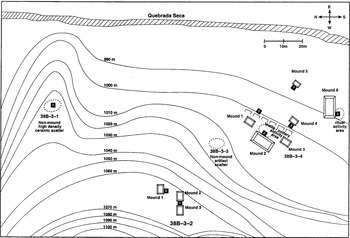
Settlement and test-pit data from Copan indicate that rural households consisted of a cluster of discrete sites performing a range of functions that together defined a household's landscape usage as illustrated by the 38B site cluster (Figure 3). It is composed of a larger Type 2 site (38B-3-4) consisting of six cut-stone structures, two of which (Mounds 2 and 6) had some sculptural elements. Togographically above this Type 2 site was a much smaller Type 1 site (38B-3-2) composed of three low (30 cm high) mounds. Between these two residential sites were two non-mound artifact clusters, each covering an area of approximately 50 m2, their surface scatters being primarily ceramics.

Copan Rural Household 38B-3 Complex.
A total of eight test pits was excavated in three of the four sites, which yielded data indicating that they were roughly contemporaneous (Late Classic-period Coner phase), allowing for the identification of specific activity areas within 38B-3-4. Unit 2, located on the eastern (plaza) side of Mound 2, exposed a cut-stone staircase and cobble plaza floor level where a serpentine celt (identified at Copan with pottery production [Freter 1996]) and a molded, incised spindle whorl fragment were encountered. Unit 5, excavated along the south side of Mound 6, which was 1.5 m high with cut-stone construction, yielded low ceramic frequencies compared with the other test pits and totally lacked lithics and ground-stone artifacts. The limited ceramic sherds recovered from unit 5, however, included a Copador cylinder, several Sepultura calderas, a Titichon incensario fragment, and a range of Casaca and Raul jar forms. The general lack of a domestic assemblage associated with Mound 6, along with its relatively large area and height and relative spatial isolation indicate that this mound served a ritual function. It is interesting to note that it is located on the extreme south of the site, while the plaza floor activity area with textile and pottery tools is located in the northwestern section of the site. While cut stone was present on the surface of the smaller Type 1 site, 38B-3-2, the mound walls exposed were constructed of unfaced river cobbles, and neither test pit encountered a paved floor. This site did contain a shallow, light density of domestic ceramics, including a wide range of Late Classic, Coner-phase vessel types and forms (jars, calderas, hemispherical bowls, and comals). In addition, 12 obsidian artifacts were recovered, including eight prismatic blades. No ground-stone artifacts were recovered from the test pitting of this site.
Both of the non-mound sites (38B-3-1 and 38B-3-3) were defined on the basis of surface ceramic scatters. Site 38B-3-1 was test excavated, yielding an extremely heavy concentration of ceramics, including jars, calderas, and bowls. The only lithics encountered were two small obsidian blades. A small amount of surfaced barro quemado also was encountered in the soil matrix at the same level as the ceramic concentration. Thus, it appears that this site served as a storage facility constructed of wattle and daub.
From these test-excavation data it is clear that the 38B site complex conforms extremely well to Wisdom's (1940) description of a Chorti extended family unit. More important archaeologically, this Maya household not only consisted of several distinct “sites”; it also occupied the land adjoining them, including a cross-section of the Quebrada Seca river valley, from the river itself to the river alluvium to the terrace on which 38B-3-4 was built, up 50 m to the higher terraces, and the forest beyond. Thus, this Copan household had ready access to water, prime agricultural land, alluvial terrace for orchards, and the high forest, a reservoir for firewood (Abrams and Rue 1988) and animal resources (Pohl 1994).
In addition, the relationship between Sites 38B-3-4 and 38B-3-2 can be viewed in terms of the developmental cycle of an extended-family household. Mound 2 at 38B-3-4 had undergone at least two construction phases, the second producing the cut-stone staircase and plaza floor paving, while the relatively low and small structures at 38B-3-2 appear to have been single-phase constructions that were associated with shallow, light domestic artifact densities. It is plausible that they were occupied by a married child of the original site founder at 38B-3-4 and represent the growth of the extended family over time. It should be noted that the 38B site complex is just one of more than 100 similar household occupations located in Copan's Rural Region from which we have comparable test-pit data, allowing the reconstruction of how these households were interwoven to create the community level.
RURAL COPAN COMMUNITY STRUCTURE
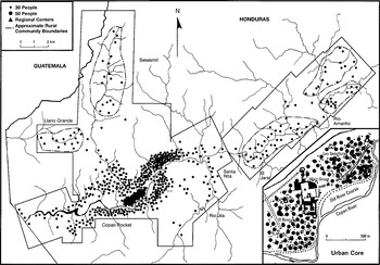
Settlement data from Copan also indicate that several households, such as the one just described, were integrated into a larger community's social-interaction sphere, again very similar to Wisdom's (1940) description of the sian otot. These rural communities occupied well-defined geographic areas, often with natural physiographic borders (rivers, mountains, etc.) and boundaries consisting of land absent of archaeologically defined structures (Figure 2). Each of these rural communities had a range of contemporaneous settlements, including one site that was much larger and more elaborate than the rest, likely representing the lineal head of the community. In addition to these rural settlement community clusters, test excavation data indicated that these sites were behaviorally integrated via both shared ritual space and economic cooperation.
Each settlement cluster contains one large site that, based on its architecture, relative size, elaborate construction, placement, and chronological longevity (Paine and Freter 1996), clearly served as a ritual center for the community. The variations in form and construction of each ritual center were marked between communities. Some were isolated ritual centers without domestic habitations, as was the case at El Jaral and Llano Grande; others—for example, in El Limon and Rio Amarillo—were composed of an elaborate domestic site containing a significantly larger mound and ritual space serving in this capacity, which were founded during the Middle Classic period. Thus, some aspect of community-wide, shared ritual solidarity can be inferred from the settlement data, but significant temporal and organizational variation among communities existed.
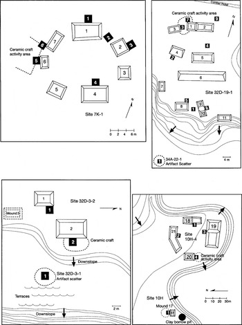
Another example of larger community social networks and their implications was encountered during the test excavation of rural sites. Seven of the Copan Valley test-pitted sites produced direct evidence of small-scale pottery production (Freter 1996). Three of the sites were specialized non-residential non-mound or single-mound sites, while the remaining four were non-elite Type 1 or 2 residential sites (Figure 4). These sites form paired patterns, with each specialized non-mound or single-mound site located within 100 m of a residential site. The distribution of these sites strongly correlates with the location of known pottery clay sources (Freter 1996), and all were utilized during the height of the Classic period. By extrapolation, at least 21 such paired production sites operated within the Copan Valley during the Late Classic period. No evidence of firing kilns was uncovered. Rather, it appears that the non-mound sites were loci for the open firing of ceramics, as indicated by waster sherds, burnt clay floors, and large ash lenses confined to a 2 m2 area. For example, Site 32D-3-1 served as the firing area for Site 32D-3-2 (Figure 4). Alternatively, ceramic activity areas associated with the residences (e.g., Site 32D-3-2) contained pigments; basalt stone slabs used to mix pigments; a smaller number of waster, misfired, or warped sherds; and fragments of small serpentine celts used as ceramic burnishing tools, although often not identified as such (Freter 1996).

Copan pottery-production site clusters (modified from Freter 1996).
Based on these data, several inferences about community ceramic production are possible. First, rural utilitarian pottery was produced in many locations on a very small scale, most likely for both local community consumption and exchange outside of the community, given the unique distribution pattern of utilitarian ceramic types at Copan (Freter 1996). Second, given the limited scale of production, each activity area was used by part-time specialists. Third, utilitarian production was conducted on a local level through either extended-family or lineage cooperatives. It appears likely that economic cooperatives above the household operating with each sian otot played a significant role, because not all residential courtyards have firing areas. Thus, potters from several different households had to at least fire their pots in a collective manner.
The paired pattern of sites suggests that vessels were fired at non-mound sites near but not within residences, probably for basic safety reasons, a finding very consistent with the ethnoarchaeology of pottery in the Naco Valley of Honduras (Connell 2002). These non-dwelling areas have been overlooked because archaeologists typically focus on the actual dwelling rather than areas near and beyond the building. At Copan, we systematically removed large areas of associated work space and focused on test-pitting both non-mound sites and those with structures so that a more complete sample of work spaces was exposed. This evidence of community ceramic economic cooperatives suggests strong social networks among community members that required wider community integration than the household level during the Late Classic period.
From this analysis of commoner structure, the economic cooperative is seen as a significant community social force, and economic cooperatives may not have been limited to ceramics. Plaster (Abrams and Freter 1996), woodworking and obsidian tool production (Mallory 1984), ground-stone mano/metate production (Spink 1983), textiles (Hendon 1996), and specialized shell and bone working (Hendon 1996; Widmer 1983) also have been identified, and their spatial distribution indicates they were conducted by various sian otot communities. The degree of intensity and integration of units such as economic cooperatives emphasizes the need for any sociopolitical model of the Maya not just to consider households of the commoners or the elite, but also to investigate the interweave of multiple social connections among all levels of society.
THE DYNAMIC PROCESS OF RURAL COMMUNITY FORMATION
Briefly considering Copan's cultural history allows the examination of community responses to changes in the larger Copan sociopolitical system and demonstrates that these social units were not static, unchanging constructs. Based on settlement data, test excavations, and current chronological and demographic modeling (Fash 1983; Freter 1994; Paine et al. 1995), 1,000 or fewer people occupied the Copan Valley before a.d. 400, while in a.d. 400–550 the estimated population was 1,000–4,000 people (Freter 1994; Paine et al. 1995). Abrams (1995:207) suggested that during this period a long-term forest swidden system would have been in operation, given the population densities and agricultural resource base, and a positive marginal labor product would have endured for these generations, preventing the economic conditions that gave significant political leverage to the elite. That is, when farmers are highly productive but limited in number, political exploitation is more likely to be muted, given the value of each farmer. The rural settlement data support this interpretation: although small, scattered rural households existed in several parts of the valley during this time period, no strong social ranking or rural political centralization is evident.
The Copan Valley's population grew rapidly between a.d. 550 and 700, to approximately 9,000 people (Freter 1994; Paine et al. 1995). Abrams (1995:207) suggested that this was a period of declining marginal productivity, thus lowering the economic value commoners' labor while increasing their swidden agricultural risk, resulting in greater political leverage by the elite. He further argued that attempts to continue wide-scale swidden cultivation eventually would have lowered the total product, a condition offset by the intensification of the alluvial bottomlands by the elite. John Wingard's (1992, 1996) agricultural simulation of the Copan Valley predicts the need for the intensification of the bottomland during the Middle Classic period, while this same time period witnessed significant architectural construction related to increasing political power (Abrams 1989) and the rise of the Copan dynastic power of Smoke-Imix God K's (a.d. 628–695 [Stuart 1993]). Thus, the concentration of population within the Copan Pocket that begins during this time period is consistent with the growth in political power, as is the formation of rural communities and some rural ceremonial centers that appear to have been founded during this time. Unfortunately, the scale and role of these initial centers remains unclear since their earlier structures could not be extensively investigated by the rural test excavations: destructive structure trenching for earlier occupation phases was prohibited when site restoration was not a funded aspect of the research design.
During the height of the Late Classic period (a.d. 700–850; Figure 5), the population reached a maximum of approximately 24,000 (Freter 1994). Intensification of the bottomlands by the now dynastic king and ruling elite who controlled them must have continued. It is during this stage that rural sian otot communities, having already contributed labor to the intensified agricultural system, began to specialize in specific nonagricultural goods such as plaster, woodworking, and ceramics to diversify the use of their labor, creating the environment for economic cooperatives to develop. Interestingly, the extent of economic cooperatives valley wide reached its height between a.d. 800 and 850. If this trend had continued, Copan would have evolved into an ever increasingly stratified state system, eventually resulting in complete organic economic integration as defined by Durkheim (1933). Instead, as the agricultural infrastructure began to fail circa a.d. 800–850 (Abrams et al. 1996; Wingard 1996), these increasingly stratified sociopolitical relationships could not continue to be supported, and relationships altered, resulting in the demise of centralized dynastic rule and a reorganization at the community level. This reorganization and decentralization of the political structure denotes the collapse of the Late Classic political system and the advent of a new sociopolitical structure that continued in the Copan Valley well into the thirteenth century (Freter 1994). The value of this temporal exercise is to suggest that the rural sian otot responded to changes in the demographic, agricultural, and economic conditions and do not represent a static set of societal relations.

Copan rural communities, a.d. 700–850 (modified from Freter 1992:167, Figure 77).
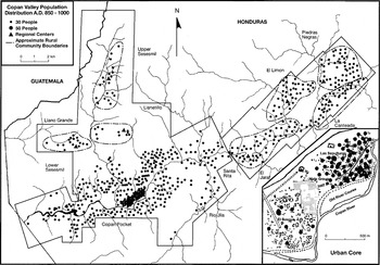
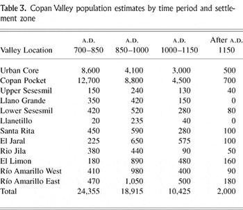
An agricultural simulation of the Copan Valley (Wingard 1992, 1996) demonstrates that, between a.d. 800 and 830, wide-scale sheet erosion occurred as a result of the over-utilization of the foothills and upland forests to fulfill the agricultural fuel and settlement needs of the rapidly growing Late Classic population (Abrams and Rue 1988; Abrams et al. 1996). The scale of agroeconomic failure is manifest in the levels of nutritional stress experienced by all social segments of the Late Classic Copan population (Storey 1992, 1999; Whittington 1991), the increased consumption of coyol and other previously marginal foods (Lentz 1991), and the destruction of the upland forests as witnessed by the pollen profiles (Rue 1987) and extreme sheet erosion (Webster et al. 2000). As a result, the Copan Valley population began a steady decline. From a.d. 850 to 1000 (Figure 6) it decreased significantly, from its height of 24,000 down to 18,000; while from a.d. 1000 to 1150 (Figure 7), it declined again to 10,000 (Freter 1992, 1994; Webster et al. 1992).

Copan rural communities, a.d. 850–1000 (modified from Freter 1992:168, Figure 78).

Copan rural communities, a.d. 1000–1150 (modified from Freter 1992:169, Figure 79).
The fluctuating–labor-value model (Abrams 1995) predicts that, with this declining population and agricultural crisis, the equation of marginal labor value would have reversed, increasing the economic value of the surviving commoners and decreasing the political control of the ruling elite. During this process, the rural communities established—or, in cases, re-established—their own ritual/administrative center, which continued to provide ritual functions in the absence of the royal dynasty. The chronology of these ritual centers has long added to the debates over the accuracy of the obsidian-hydration dating project at Copan (Braswell 1992; Webster et al. 1993; Webster et al. 2004), since the hydration dates indicate relatively late resettlement of some ritual centers that also contained Middle Classic occupations. These late resettlements of ancestral ritual centers are in fact predicted by both Abrams's (1995) fluctuating-labor model and the ancient Copan sian otot model, in which ancestor worship and ritual rights empowered the community and legitimized their claim to specific landed territories.
The demographic growth and decline of these rural communities from a.d. 700 to 1150 (Table 3) illustrates one of the remaining methodological challenges. As Reed and Gonlin (1996) noted, the spatial extent of each specific community is temporally fluid due to demographic changes experienced after the decentralization of the Copan polity and its accompanying process of out-migration. Related to this issue is the fact that these late settlements varied significantly in settlement type, many reestablishing households in areas settled hundreds of years before, often looting previous structures for new construction materials. Hence, while these communities grew very rapidly from a.d. 850 to 1000, they undoubtedly changed in composition, organization, and scale.
Copan Valley population estimates by time period and settlement zone

ARCHAEOLOGICAL IMPLICATIONS OF THE COPAN ANCIENT SIAN OTOT MODEL
The value of any model lies not only in its ability to accurately describe a specific data set but also in its residuals—that is, the new research questions and directions that it generates. Clearly, the strength of the multiscalar Copan ancient sian otot model lies in its archaeological implications and material-culture testability. A clear archaeological implication of this model is the importance of non-mound sites and “empty” space surrounding structures, which have traditionally been overlooked by Maya scholars (but see Johnston 2002). The realization that significant household activities were conducted outside the traditionally defined “mound site” area implies that pivotal economic activities—for example, ceramic cooperatives—have been systematically missed using standard data-collection methods. Furthermore, the spatial utilization of a household cannot be clearly understood until the entire set of lands associated with Maya dwellings is equally considered an aspect of the “household.”
Second, this model predicts potential locations for specific types of data needed for diverse research questions. For example, far fewer rural burials were recovered than would be expected, and those located were disproportionally women and children (Whittington 1991). This lack of data and skewed sample have hampered comparisons between rural and urban population diet and health status. Yet the ancient sian otot model predicts a family burial plot that is spatially discrete from the residential site core. Patrifocal, adult males might have been buried here rather than in the residential area with affinal females and young children. This possibility of a differential burial pattern should be tested.
Third, this model generates ways to archaeologically test complex behavioral social organizational concepts such as lineal descent and marriage patterns. The ancient sian otot appears to be very consistent with a patrifocal descent and marriage residence pattern, yet the endogamy within Chorti sian otot is especially interesting to test archaeologically. If this was the case at Copan, then women would be likely to have remained in their natal sian otot after marriage; thus, sian otot symbolic identifiers could be learned from a young age and would not necessarily change after marriage. Hypothetically, symbolic sian otot definers might be discernable in ceramic design elements, in textile patterns (if any were well preserved), as sculptural elements on structure facades, or as community emblem glyphs. While this line of inquiry has proved useful in other areas in the Maya region (Freter 1981), it has not yet been attempted at Copan but may assist with the definition of formal boundaries between communities.
The question of elite polygyny suggested by Sanders (1989) also can be investigated archaeologically based on the site ranking within each community and the number and extent of multiroom range structures present at sites identified as potential rural community/lineage heads. While the Colonial-period Maya were not reported to have polygynous marriages, changes in marriage pattern due to European contact and sociopolitical disintegration are probable. Polygynous marriages of the elite and rural lineage heads would be a logical extension of a patrifocal, endogamous organization, especially if female labor was a significant aspect of the economy. This question requires more concentrated archaeological investigation.
Last, the incorporation of Abrams's (1995) fluctuating-labor analysis into a broader sociopolitical model generates a series of questions related to the Maya domestic economy and its integration into the larger economic structure of the Copan polity. It allows an investigation of domestic production to transcend investigations of production nodes, production time costs, and consumer identification and starts to address the effects of such production on the domestic group. It predicts when commoner labor could be most effectively drawn by the elite to the mutual benefit of both parties and when such elite economic demand becomes a burden to the domestic group. Thus, as resources change, such as the availability of forest-fallow agricultural land, the household's labor requirements concomitantly adjust, resulting in altered labor values that modify household decision-making. Consequently, alterations in the domestic economy of households can be considered in relation to changes in the political economy, illuminating broader sociopolitical processes and linking them structurally to household production. The cooperatives suggested here are one type of economic modification available on the household level.
In sum, the past 20 years of archaeological research in the realm of Maya settlement and household archaeology justify continued research aimed at understanding the basic domestic economy and its impact on the social actors. To do this effectively, we need to employ multiscalar frameworks that honor the depth, complexity, and variation of our data, allowing us to investigate the intersecting weave of Maya social organization dynamically. Thus, if we take a holistic approach, centered on all social, temporal, and spatial levels through time, we can begin to reconstruct the depth of the Maya social fabric and the degree to which intersections among various social units over time reconfigured to create the growth, height, and collapse of this complex civilization.
RESUMEN
La segunda fase del Proyecto Arqueólogico Copan (PAC II), Honduras, incluyó un extenso reconocimiento arqueológico en un área de 135 km2 con excavaciones a gran escala y pozos de sondeo. Un componente grande de este reconocimento implicó el área rural del valle de Copan. De estos datos es posible producir varios modelos sobre la estructura sociopolítica de los mayas del período clásico tardío. Todos los datos implican la importancia de modelos diferentes y también para zonas diferentes de ocupación en el valle. Se examina la relación entre la complejidad de los modelos y la producción económica, especialmente en el área rural. La población del clásico produjo cerámica en una estructura diferente de la población en los otros períodos como un ejemplo de la diversidad en la organización de los mayas.
ACKNOWLEDGMENTS
This paper was the brainchild of the 2001 Symposium on Maya Social Organization organized by Jon Hageman. Without his vision and encouragement, it would not have been written. I am also indebted to the co-participants and attendees of that session, whose insights and lively debate greatly influenced this work. The research for this paper was funded by a series of National Science Foundation grants (BNS 82-19421, BNS 84-19933, BNS 87-20027) and was supported by the Instituto Hondureño de Antropología e Historia. Conducting research at Copan continues to be a collaborative venture, and this work in particular has been greatly influenced and improved through discussions over the years with Elliot Abrams, William Fash, Nancy Gonlin, Julia Hendon, John Mallory, David Rue, William T. Sanders, Rebecca Storey, David L. Webster, Stephen Whittington, and John Wingard. Peg Sattler and Kate Anderson graciously prepared the figures and tables. Several reviewers also contributed to the focus and clarity of the ideas presented, and their time and constructive criticism are greatly appreciated. Last, special thanks to my husband, without whose support, encouragement, and fine editing skills this paper would not have been completed, and to my son, who respected mom's closed office door more often than not yet was always a sunny and welcome diversion.
References
REFERENCES
Abrams, Elliot M.
1987
Economic Specialization and Construction Personnel in Classic
Period Copan, Honduras.
American Antiquity
52:485–499.Google Scholar
Abrams, Elliot M.
1989
Architecture and Energy: An Evolutionary Perspective. In
Archaeological Method and Theory, Vol. 1, edited by
Michael Shiffer, pp.
47–88.
University of Arizona Press,
Tucson.
Abrams, Elliot M.
1994
How the Maya Built Their World: Energetics and Ancient Architecture.
University of Texas Press,
Austin.
Abrams, Elliot M.
1995
A Model of Fluctuating Labor Value and the Establishment of State
Power: An Application to the Prehispanic Maya.
Latin American Antiquity
60:196–213.Google Scholar
Abrams, Elliot M., and
AnnCorinne Freter
1996
A Late Classic Lime-Plaster Kiln from the Maya Centre of Copan,
Honduras.
Antiquity
70:422–428.Google Scholar
Abrams, Elliot M., and
David J. Rue
1988
The Causes and Consequences of Deforestation Among the Prehistoric
Maya.
Human Ecology
16:377–395.Google Scholar
Abrams, Elliot M.,
AnnCorinne Freter,
David J. Rue, and
John D. Wingard
1996
The Role of Deforestation in the Collapse of the Late Classic
Copan Maya State. In
Tropical Deforestation: The Human Dimension, edited by
Leslie E. Sponsel,
Thomas N. Headland, and
Robert C. Bailey, pp.
53–75.
Columbia University Press,
New York.
Adams, Richard N.
1981
The Dynamics of Societal Diversity: Notes from Nicaragua for a
Sociology of Survival.
American Ethnologist
8:1–20.Google Scholar
Andrews, E. Wyllys V, and
Barbara W. Fash
1992
Continuity and Change in a Royal Maya Residential Complex at Copan.
Ancient Mesoamerica
3:63–88.Google Scholar
Ashmore, Wendy
1991
Site-Planning Principles and Concepts of Directionality Among the
Ancient Maya.
Latin American Antiquity
2:199–226.Google Scholar
Bender, Donald R.
1967
A Redefinement of the Concept of Household: Families Coresidence
and Domestic Functions.
American Anthropologist
69:493–504.Google Scholar
Braswell, Geoffrey E.
1992
Obsidian-Hydration Dating, the Coner Phase, and Revisionist
Chronology at Copan, Honduras.
Latin American Antiquity
3:130–147.Google Scholar
Brumfiel, Elizabeth M. (editor)
1994
The Economic Anthropology of the State.
University Press of America,
Lanham, MD.
Connell, Samuel V.
2002
Getting Closer to the Source: Using Ethnoarchaeology to Find
Ancient Pottery Making in the Naco Valley, Honduras.
Latin American Antiquity
13:401–419.Google Scholar
Demarest, Arthur
1992
Ideology in Ancient Maya Cultural Evolution: The Dynamics of
Galactic Polities. In
Ideology and Pre-Columbian Civilizations, edited by
Arthur A. Demarest and
Geoffrey Conrad, pp.
135–157.
School of American Research Press,
Santa Fe, NM.
Diamanti, Melissa
1991
Domestic Organization at Copan: Reconstruction of Elite Maya
Households Through Ethnographic Models.
Ph.D. dissertation,
Department of Anthropology, Pennsylvania State University,
University Park.
University Microfilms,
Ann Arbor, MI.
Durkheim, Emile
1933
The Division of Labor in Society.
Macmillan,
New York.
Fash, William L.
1983
Deducing Social Organization from Classic Maya Settlement
Patterns: A Case Study from the Copan Valley. In
Civilization in the Ancient Americas: Essays in Honor of Gordon R.
Willey, edited by
Richard M. Leventhal and
Alan L. Kolata, pp.
261–585.
University of New Mexico Press,
Albuquerque, and
Peabody Museum of Archaeology and Ethnology, Harvard University,
Cambridge, MA.
Fox, John W.,
Garrett W. Cook,
Arlen F. Chase, and
Diane Z. Chase
1996
The Maya State: Centralized or Segmentary?
Current Anthropology
37:795–830.Google Scholar
Freter, AnnCorinne
1981
Was the Quiche State a State? A Reanalysis of the Utatlan Residence
Zone Data.
Unpublished master's thesis,
Department of Anthropology, University of Houston,
Houston.
Freter, AnnCorinne
1992
Chronological Research at Copan: Methods and Implications.
Ancient Mesoamerica
3:117–134Google Scholar
Freter, AnnCorinne
1994
The Classic Maya Collapse at Copan, Honduras: An Analysis of Maya
Rural Settlement Trends. In
Village Communities in Early Complex Societies, edited by
Glen M. Schwartz and
Stephen E. Falconer, pp.
160–176.
Smithsonian Institution Press,
Washington, DC.
Freter, AnnCorinne
1996
Rural Utilitarian Ceramic Production in the Late Classic Period
Copan Maya State. In
Arqueologia mesoamericana: Homenje a William T. Sanders II, edited by
Alba Guadalupe Mastache,
Jeffrey R. Parsons,
Robert S. Santley, and
Mari Carmen Serra Puche, pp.
209–230.
Instituto Nacional de Anthropología e Historia,
Mexico City.
Fried, Morton
1967
The Evolution of Political Society.
Random House,
New York.
Goody, Jack
1972
The Evolution of the Family. In
Household and Family in Past Time, edited by
Peter Laslett and
Richard Wall, pp.
103–124.
Cambridge University Press,
Cambridge.
Halperin, Rhoda H.
1988
Economies Across Cultures: Towards a Comparative Science of the
Economy.
St. Martin's Press,
New York.
Hendon, Julia A.
1991
Status and Power in Classic Maya Society: An Archaeological Study.
American Anthropologist
93:894–918.Google Scholar
Hendon, Julia A.
1996
Archaeological Approaches to the Organization of Domestic Labor:
Household Practice and Domestic Relations.
Annual Reviews in Anthropology
25:45–61.Google Scholar
Johnston, Kevin J.
2002
Protrusion, Bioturbation, and Settlement Detection During Surface
Survey: The Lowland Maya Case.
Journal of Archaeological Method and Theory
9:1–67.Google Scholar
Johnston, Kevin J., and
Nancy Gonlin
1998
What Do Houses Mean? Approaches to the Analysis of Classic Maya
Commoner Residences. In Function and Meaning in Classic Maya
Architecture, edited by
Stephen D. Houston, pp.
141–187,
Dumbarton Oaks,
Washington, DC.
Joyce, Rosemary A., and
Susan D. Gillespie (editors)
2000
Beyond Kinship: Social and Material Reproduction in House Societies.
University of Pennsylvania Press,
Philadelphia.
Lentz, David L.
1991
Maya Diets of the Rich and Poor: Paleoethnobotanical Evidence from
Copan.
Latin American Antiquity
2:269–287.Google Scholar
Mallory, John K.
1984
The Place of Obsidian in the Economy of Copan.
Ph.D. dissertation,
Department of Anthropology, Pennsylvania State University,
University Park.
Moran, Emilio F.
1990
Levels of Analysis and Analytical Level Shifting: Examples from
Amazonian Ecosystem Research. In
The Ecosystem Approach in Anthropology from Concept to Practice,
edited by
Emilio F. Moran, p.
279–308.
University of Michigan Press,
Ann Arbor.
Morgan, Lewis Henry
1880
A Study of the Houses of the American Aborigines: Annual Report of
the Executive Committee.
Archaeological Institute of North America
1:29–80.Google Scholar
Nelson, Sarah Milledge
1997
Gender in Archaeology: Analyzing Power and Prestige.
Altamira Press,
Walnut Creek, CA.
Paine, Richard R., and
AnnCorinne Freter
1996
Environmental Degradation and the Classic Maya Collapse at Copan,
Honduras (A.D. 600–1250): Evidence from Studies of Household
Survival.
Ancient Mesoamerica
7:37–47.Google Scholar
Paine, Richard R.,
AnnCorinne Freter, and
David L. Webster
1995
A Mathematical Projection of Population Growth in the Copan Valley,
Honduras, A.D. 400–800.
Latin American Antiquity
7:51–60.Google Scholar
Pohl, Mary D.
1994
Appendix D: Late Classic Maya Fauna from Settlement in the Copan
Valley, Honduras: Assertion of Social Status Through Animal
Consumption. In
Ceramics and Artifacts from Excavations in the Copan Residential
Zone, edited by
Gordon R. Willey,
Richard M. Leventhal,
Arthur A. Demarest, and
William L. Fash_Jr., pp.
459–476.
Papers of the Peabody Museum of Archaeology Ethnology, Vol. 80.
Harvard University,
Cambridge, MA.
Proskouriakoff, Tatiana
1960
Historical Implications of a Pattern of Dates at Piedras Negras,
Guatemala.
American Antiquity
25:454–475.Google Scholar
Reed, David, and
Nancy Gonlin
1996
The Reconstruction of Ancient Copan Communities.
Paper presented at the 61st Annual Meeting of the Society for
American Archaeology,
New Orleans.
Rue, David J.
1987
Early Agriculture and Early Postclassic Occupation in Western
Honduras.
Nature
326:285–286.Google Scholar
Sanders, William T.
1989
Household, Lineage, and State at Eighth-Century Copan, Honduras.
In
The House of the Bacabs, Copan, Honduras, edited by
David L. Webster.
Studies in Pre-Columbian Art and Archaeology, No. 29.
Dumbarton Oaks Research Library and Collection,
Washington, DC.
Sanders, William T., and
David L. Webster
1988
The Mesoamerican Urban Tradition.
American Anthropologist
90:521–546.Google Scholar
Sheehy, James J.
1991
Structure and Change in a Late Classic Maya Domestic Group at
Copan, Honduras.
Ancient Mesoamerica
2:1–19.Google Scholar
Spink, Mary
1983
Metates as Socioeconomic Indicators During the Classic Period at
Copan.
Ph.D. dissertation, Department of Anthropology.
Pennsylvania State University,
University Park.
Storey, Rebecca
1992
The Children of Copan: Issues in Paleopathology and
Paleodemography.
Ancient Mesoamerica
3:161–167.Google Scholar
Storey, Rebecca
1999
Late Classic Nutrition and Skeletal Indicators at Copan,
Honduras. In
Reconstructing Ancient Maya Diet, edited by
Christine D. White, pp.
169–182.
University of Utah Press,
Salt Lake City.
Stuart, David
1993
Historical Inscriptions and the Maya Collapse. In
Lowland Maya Civilization in the Eighth Century A.D., edited by
Jeremy A. Sabloff and
John S. Henderson, pp.
321–354.
Dumbarton Oaks Research Library and Collection,
Washington, DC.
Thompson, Edward H.
1886
Archaeological Research in Yucatan.
Proceedings of the American Antiquarian Society
4:248–254.Google Scholar
Thompson, J. Eric S.
1927
The Civilization of the Maya.
Field Museum of Natural History Anthropology Leaflet 25.
Chicago.
Thompson, J. Eric S.
1931
Archaeological Investigations in the Southern Cayo District,
“British Honduras.”
Field Museum of Natural History Publication 274, Anthropology Series,
Vol. 27, No. 3.
Chicago.
Webster, David L., and
AnnCorinne Freter
1990
The Demography of Late Classic Copan. In
Precolumbian Population History in the Maya Lowlands, edited by
T. Patrick Culbert and
Don S. Rice, pp.
37–62.
University of New Mexico Press,
Albuquerque.
Webster, David L., and
Nancy Gonlin
1988
Household Remains of the Humblest Maya.
Journal of Field Archaeology
15:169–190.Google Scholar
Webster, David L.,
Barbara W. Fash,
Randolph Widmer, and
Scott Zeleznik
1998
The Skyband Group: Excavations of a Classic Maya Elite Residential
Complex at Copan, Honduras.
Journal of Field Archaeology
25:391–344.Google Scholar
Webster, David L.,
AnnCorinne Freter, and
Nancy Gonlin
2000
Copan: The Rise and Fall of an Ancient Maya Kingdom.
Harcourt Brace,
Fort Worth, TX.
Webster, David L.,
AnnCorinne Freter, and
David Rue
1993
The Obsidian Hydration Dating Project at Copan: A Regional Approach
and Why It Works.
Latin American Antiquity
4:302–324.Google Scholar
Webster, David L.,
AnnCorinne Freter, and
Rebecca Storey
2004
Dating Copan Culture History: Implications for the Terminal
Classic and the Collapse. In
The Terminal Classic in the Maya Lowlands: Collapse, Transition,
and Transformation, edited by
Arthur A. Demarest,
Prudence M. Rice, and
Don S. Rice, p.
231–259.
University Press of Colorado,
Boulder.
Webster, David L.,
Nancy Gonlin, and
Payson Sheets
1997
Copan and Ceren: Two Perspectives on Ancient Mesoamerican
Households.
Ancient Mesoamerica
8:43–61.Google Scholar
Webster, David L.,
William T. Sanders, and
Peter van Rossum
1992
A Simulation of Copan Population History and Its Implications.
Ancient Mesoamerica
3:185–198.Google Scholar
Whittington, Stephen L.
1991
Detection of Significant Demographic Differences Between
Subpopulations of Prehispanic Maya from Copan, Hondauras, by Survival
Analysis.
American Journal of Physical Anthropology
85:167–184.Google Scholar
Widmer, Randolph J.
1983
Excavations in Group 9N-8 Courtyard H.
Ms on file,
Department of Anthropology, Pennsylvania State University,
University Park.
Wilk, Richard R.
1989
The Household Economy: Reconsidering the Domestic Mode of
Production.
Westview Press,
Boulder, CO.
Wilk, Richard R., and
Wendy Ashmore (editors)
1988
Household and Community in the Mesoamerican Past.
University of New Mexico Press,
Albuquerque.
Wilk, Richard R., and
William J. Rathje
1982
Household Archaeology.
American Behavioral Scientist
25:617–639.Google Scholar
Willey, Gordon R., and
Richard M. Leventhal
1979
Prehistoric Settlement at Copan. In
Maya Archaeology and Ethnohistory, edited by
Norman Hammond and
Gordon R. Willey, pp.
75–102.
University of Texas Press,
Austin.
Willey, Gordon R.,
Richard M. Leventhal,
Arthur A. Demarest, and
William L. Fash, Jr.
1994
Ceramics and Artifacts from Excavations in the Copan Residential
Zone.
Papers of the Peabody Museum of Anthropology and Ethnology, Vol.
80.
Harvard University,
Cambridge, MA.
Wingard, John
1992
The Role of Soils in the Development and Collapse of Classic Maya
Civilization at Copan, Honduras.
Ph.D. dissertation,
Pennsylvania State University,
University Park.
University Microfilms,
Ann Arbor, MI.
Wingard, John
1996
Interactions Between Demographic Processes and Soil Resources in
the Copan Valley, Honduras. In
The Managed Mosaic, edited by
Scott Fedick, pp.
207–235.
University of Utah Press,
Salt Lake City.
Wisdom, Charles
1940
The Chorti Indians of Guatemala.
University of Chicago Press,
Chicago.
Copan Valley ecological zones (modified from Freter 1994:161, Figure 74).
Copan Valley test excavations by settlement zone
Rural Copan site typology
Copan Valley site distribution in relation to topography.
Copan Rural Household 38B-3 Complex.
Copan pottery-production site clusters (modified from Freter 1996).
Copan rural communities, a.d. 700–850 (modified from Freter 1992:167, Figure 77).
Copan rural communities, a.d. 850–1000 (modified from Freter 1992:168, Figure 78).

Copan rural communities, a.d. 1000–1150 (modified from Freter 1992:169, Figure 79).
Copan Valley population estimates by time period and settlement zone
 You have
Access
- 16
- Cited by