


Introduction
Libya has an extraordinarily wide range of cultural heritage, including prehistoric rock art, Punic, Greek and Roman settlements, Late Antique and Byzantine urban centres, Islamic towns and oasis architecture. This landscape includes, but is not limited to, the country’s five UNESCO World Heritage Sites (WHS) inscribed between 1982 and 1986: the archaeological sites of Cyrene, Lepcis Magna and Sabratha, the Old Town of Ghadames and the rock-art sites of Tadrart Acacus. Libya’s heritage, however, has faced growing pressures from conflict, institutional fragmentation and environmental change (Abdulkariem and Bennett Reference Abdulkariem and Bennett2014; Alkhalaf et al. Reference Alkhalaf, Elhabashi, Hesham, Hiba, Omaar, Walda and Wootton2026; Bennett and Barker Reference Bennett and Barker2011; Kane Reference Kane2015; Leone et al. Reference Leone, Wootton, Fenwick, Nebbia, Alkhalaf, Jorayev, Othman, Alhddad, Belzic and Emrage2020; Rayne et al. Reference Rayne, Sheldrick and Nikolaus2017).
These factors have resulted not only in physical damage but also weakened management systems and maintenance regimes. Conditions have worsened since the conflict began in 2011. In 2016, all five WHS were placed on the List of World Heritage in Danger (UNESCO 2016), owing to countrywide instability and the presence of armed groups, the associated and heightened risks of damage and neglect and the lack of the necessary documentation to meet the World Heritage Convention.
Despite calls for integrated approaches in the heritage literature, relatively few projects, whether local or international, have combined architectural history, archaeology, preventive conservation and locally-grounded forms of engagement within a single framework (Avrami et al. Reference Avrami, Mason and De La Torre2000; Labadi Reference Labadi2013; Mason and Avrami Reference Mason and Avrami2002; Meskell Reference Meskell2018). Research on Libyan heritage has yielded rich insights into individual sites, regions and periods from prehistory to the present. In comparison, few studies foreground the practicalities of routine, day-to-day management under conditions of protracted crisis and environmental stress.
The Managing Libya’s Cultural Heritage project (MaLiCH) was developed in response to this need. Between 2020 and 2026, it focused on supporting local heritage professionals within the Libyan Department of Antiquities (DoA) and the Ghadames City Promotion and Development Authority (GCPDA), strengthening capacity through new programmes targeted at specific vulnerabilities, improving knowledge and understanding of the attributes and values of WHS and contributing to efforts to remove sites from UNESCO’s List of World Heritage in Danger through better management planning and reporting. Integrated with these activities were targeted conservation and maintenance interventions based on locally-assessed priorities. To guide decision-making on the preservation and use of cultural heritage, the project adopted a risk-management approach that assessed threats in relation to one another, established priorities and supported more effective resource planning (Pedersoli et al. Reference Pedersoli, Antomarchi and Michalski2016).
Methodology
The methodological approach of MaLiCH drew on the interdisciplinary experience of the project team in archaeology, architecture, conservation and heritage management, with particular attention being paid to the relationship between heritage and local communities. It was structured around an integrated framework comprising three interdependent domains: knowledge production, governance and capacity-building, and conservation and management action. Rooted in holistic heritage-management models that emphasise iterative processes of documentation, analysis and response (Mason and Avrami Reference Mason and Avrami2002), this framework served both as a conceptual model and as a practical guide for assessing sites, identifying priorities and shaping interventions. In the context of MaLiCH, it also provided a flexible structure for working under conditions of conflict, environmental stress and institutional fragility.
Knowledge production provided the evidence base for decision-making through attribute-based heritage mapping (Avrami et al. Reference Avrami, Macdonald, Mason and Myers2019), architectural and archaeological analysis and the use of digital tools such as unmanned aerial vehicles (UAVs) and photogrammetry (Stylianidis and Remondino Reference Stylianidis and Remondino2016). Governance and capacity-building created the conditions through which knowledge and action could be sustained, supported by institutional partnerships, community participation and embedded training that linked interventions with learning, skills development and local stewardship. Conservation and management action translated the evidence generated through these processes into targeted responses, including vegetation control at both archaeological sites, a mosaic reburial for a Roman bath complex and the rehabilitation and adaptive reuse of an historic building.
Across the project, these interventions were designed to be preventive, minimally invasive and, where possible, reversible (Almagro Vidal et al. Reference Almagro Vidal, Tandon and Eppich2015; Tandon Reference Tandon2018). This methodological framework was also shaped by the practical conditions in which the project operated. The need to operate remotely and seasonally, while responding to unpredictable and disrupted travel, institutional uncertainty and uneven site access, reinforced the value of an approach which integrates documentation, training and intervention within a single structure. The methodology therefore functioned not only as a way of understanding sites but also as an adaptive model for delivering the project under constrained conditions.
The project encountered several significant challenges. It commenced at the onset of the COVID-19 pandemic, when international travel and on-site fieldwork were severely restricted. Although initially conceived as a practice-based programme, it was quickly adapted to a changing operational context: training and coordination moved online, workplans and timelines were revised and alternative delivery strategies were developed to sustain implementation amid lockdowns, funding delays, slow money transfers and periods of institutional reorganisation within the DoA. The project also faced uneven access to sites and delays caused by security and administrative conditions. As a result, while the programme was able to sustain delivery and generate measurable outcomes, the time-bound nature of its interventions limited its capacity to address longer-term maintenance needs.
Rather than fully realising a comprehensive conservation model, the project developed a pragmatic set of responses to what was possible within specific institutional, environmental and operational constraints. Its value lies in the way it combined documentation, institutional support, site management, risk management and selected conservation actions in ways that were feasible within the conditions on the ground. Rather than unfolding through a fixed or ideal trajectory, the project evolved through context-specific decisions shaped by available resources, local priorities, identified risks and the practical realities of implementation across different sites (Jokilehto Reference Jokilehto2010; Wijesuriya et al. Reference Wijesuriya, Thompson and Young2013). Its contribution is therefore best understood not as the execution of a complete conservation framework but as an incremental and risk-informed process that sought to reduce vulnerability and support longer-term heritage management under constrained conditions.
Main areas of project activity
The project’s core activities can be understood through three interconnected strands of work. The first centred on capacity-building and institutional support, particularly in relation to WHS reporting. The second addressed landscape and site management through targeted vegetation management campaigns at Sabratha and Lepcis Magna. The third focused on conservation action, spanning both the delivery of specific interventions, such as the Ghadames visitor centre and the Sabratha mosaic reburial, and the technical planning and preparation required for future interventions at the Hunting Baths of Lepcis Magna. Projects in the second and third strands were selected in partnership with local collaborators and based on needs identified in the first. As such, the interventions directly connected to the report writing and responded to potential corrective measures. They addressed, therefore, the direct and indirect impacts of conflict, as well as wider strategic priorities.
Strand 1: capacity-building and World Heritage Sites reporting
The project was structured around capacity-building as a core element of its wider approach to heritage management. Drawing on relationships developed through previous collaborative work, the training programme responded to identified local needs and followed the World Heritage Capacity Building Strategy (WHCBS) adopted in 2011 (UNESCO 2011). It aimed to strengthen the knowledge and practice of heritage staff, while encouraging a more inclusive (Wootton et al. Reference Wootton, Alkhalaf, El-Habashi and Walda2026) understanding of heritage that linked local and universal values (Almagro Vidal et al. Reference Almagro Vidal, Tandon and Eppich2015).
The capacity-building programme involved 24 participants from four DoA offices in Tripoli, Lepcis Magna, Sabratha and Ghadames, in addition to the GCPDA. The project team, together with invited heritage specialists, delivered online training in Arabic introducing the World Heritage Convention, the challenges of safeguarding heritage in Libya and key principles of heritage management, including site values, attributes, authenticity, integrity and community engagement and stakeholder mapping. Delivered through pre-recorded materials and online sessions, it combined theoretical principles with practical exercises. It was also made available through the project’s YouTube channel to accommodate variable internet access and repeat viewings. Teams from the DoA and GCPDA, working both remotely and through seasonal site visits, co-produced new documentation and research which informed subsequent training sessions and activities.
The programme fed directly into World-Heritage reporting. This was particularly successful at the Old Town of Ghadames, where co-production of the Desired State of Conservation Report (DSOCR) and the retrospective Statement of Outstanding Universal Value (RSOUV) led to the site’s removal from the List of World Heritage in Danger. MaLiCH supported the identification of site attributes, the assessment of conflict impacts and the development of corrective measures and timelines (Alkhalaf et al. Reference Alkhalaf, Elhabashi, Hesham, Hiba, Omaar, Walda and Wootton2026). Progress was most advanced in Ghadames, reflecting strong local engagement through the GCPDA within the wider framework of the DoA’s responsibilities as the State Party. The experience generated through this process also informed the collaboration with the DoA in terms of reporting practices, stakeholder coordination and compiling attributes and values at complex archaeological sites. The removal of Ghadames from the In Danger List at the 47th session of the World Heritage Committee represented both a major milestone and a useful point of reference for future work elsewhere.Footnote 1
Digital technologies formed an integral part of MaLiCH’s approach to capacity building, supporting both documentation and decision-making. Unmanned Aerial Vehicles (UAV), photogrammetric methods, GIS and related skills targeted at specific needs were used to record site condition, assess environmental and conservation risks and guide intervention priorities (Stylianidis and Remondino Reference Stylianidis and Remondino2016). In Ghadames, these tools helped situate the Old Town within its wider environmental context, while at Lepcis Magna and Sabratha they enabled the analysis of vegetation patterns, access constraints and areas of heightened vulnerability. Integrated into site documentation and management workflows, these methods contributed to a more systematic and risk-informed approach to the prioritisation of interventions and site monitoring.
Strand 2: vegetation management as site stewardship at Sabratha and Lepcis Magna
Archaeological sites along the Tripolitanian coastline have long been exposed to significant environmental risks, but their marine context is becoming increasingly hazardous with climate change (Mattingly Reference Mattingly2019; Westley et al. Reference Westley, Andreou, El Safadi, Huigens, Nikolaus, Ortiz-Vazquez, Ray, Smith, Tews and Blue2023). The threat of coastal erosion is well known at both World Heritage sites of Lepcis Magna and Sabratha (Reimann et al. Reference Reimann, Vafeidis, Brown, Hinkel and Tol2018). Lepcis Magna is also subject to sand encroachment and episodic flooding. The rapid intensification of these dangers now intersects with a further issue: uncontrolled vegetation growth exacerbated by the absence of regular maintenance and changing seasonal weather patterns (D’Urso et al. Reference D’Urso, Ombrelli, Telaroli, Calesso, Badin, Senigaglia, Urrutia and Sterponi2015; Westley et al. Reference Westley, Andreou, El Safadi, Huigens, Nikolaus, Ortiz-Vazquez, Ray, Smith, Tews and Blue2023).
Vegetation is a valuable contributor to biodiversity on these sites while also moderating the local microclimate by reducing solar exposure, humidity and temperature (Caneva Reference Caneva1999). Plants can play an important stabilising role, reducing erosion or the collapse of landscape elements such as hills, dunes or banks. The relationship between heritage and ecology is increasingly being recognised and considered (UNESCO 1972). Conserving and managing cultural heritage should not only focus on historical and cultural significance but also on the maintenance of the natural features and ecological processes that coexist with, and in some cases help sustain, the built environment (Caneva et al. Reference Caneva, Hosseini and Bartoli2023). The significance of these natural and semi-natural landscape functions can be difficult to define, however, and archaeological frameworks are primarily geared towards the assessment of built not environmental attributes.
When considering the management of both Lepcis Magna and Sabratha, therefore, it is important to identify vegetation which creates a diverse ecology, supports the natural landscape and enhances the appeal and experience of the site. At the same time, however, these need to be distinguished from those plants that materially accelerate decay (Zangari et al. Reference Zangari, Bartoli, Lucchese and Caneva2023). Vegetation contributes to deterioration through multiple pathways, including the mechanical, chemical and biological, and its effects vary according to substrate, architectural form and patterns of maintenance. As Caneva has emphasised, the impact of vegetation is not uniform but depends on species, rooting depth, growth dynamics and life cycle; all these factors condition whether plants act as stabilising agents or drivers of physical and chemical decay (Caneva Reference Caneva, Hosseini and Bartoli2023/Reference Caneva1999). A balanced, risk-based approach ensures that the ‘natural value’ is neither assumed nor dismissed, especially in the absence of formal evaluation. It also distinguishes between vegetation which contributes to the functioning of the ecosystem and species whose growth regimes increase the vulnerability of archaeological materials.
Lepcis Magna and Sabratha share broadly comparable risk profiles and since 2011 have had similar constraints on routine maintenance and site management. Reduced institutional capacity, financial restrictions and intermittent operational disruption have limited regular upkeep. This has resulted in vegetation colonising masonry, particularly problematic with perennials and shrubs whose deep roots penetrate walls, floors and foundations, widening joints and cracks, displacing blocks and progressively weakening structures by mechanical action. Dense vegetation covering monuments traps moisture, accelerating salt- and bio-weathering. It also obscures architectural features, obstructs drainage routes, provides concealment for pests, vandals and looters, and increases the risk of fire when dry (Cicinelli et al. Reference Cicinelli, Salerno and Caneva2018; Caneva et al. Reference Caneva, Hosseini and Bartoli2023). The overall result is not only progressive material deterioration but also an increasingly difficult environment for inspection, documentation and safe access (Alkhalaf et al. Reference Alkhalaf, Elhabashi, Hesham, Hiba, Omaar, Walda and Wootton2026).
The methodological response is to assess the vegetation and its extent using the available botanical knowledge, improving understanding of root behaviour and regrowth cycles (Caneva et al. Reference Caneva, Hosseini and Bartoli2023; Zangari et al. Reference Zangari, Bartoli, Lucchese and Caneva2023). The steps following evaluation prioritise manual removal and reserve any chemical treatment for carefully selected cases. This approach aligns with the conservation debates that question the routine use of herbicides at archaeological sites and advocates for environmentally- and monument-friendly methods of controlling vegetation (Papafotiou et al. Reference Papafotiou, Kanellou and Economou2016). The assessments showed that Lepcis Magna had a much more varied flora than at Sabratha. Both sites had significant issues, however, with mechanical and chemical actions. For example, at Lepcis Magna, deep-rooted perennials were causing significant decay along the walls of the main streets, in the Hadrianic Baths and the Severan Forum. The same was happening across Sabratha with one specific shrub growing around the Forum, in Regios VI and VII.
In 2024, the project focused on collaborating with the DoA on vegetation control with the aim of developing and testing methods that were both monument sensitive and environmentally responsible and integrating them within a longer-term maintenance strategy. The approach combined documentation, risk assessment and targeted intervention. UAV-based aerial photography and photogrammetric recording, supported by archival review, GIS analysis and systematic ground inspection, were used to map vegetation extent and patterning, identify priority risk zones, and generate baseline ‘before-and-after’ records for future monitoring (see Figure 2 and Figure 3). The first campaigns took place at Lepcis Magna from February to March and then May to June 2024. The project focused on eight principal architectural complexes: the Punic Market, the theatre, the porticus post scaenam and its immediate environs, the Decumanus Maximus and Arch of Septimius Severus, the Schola, the Hadrianic Baths, the Chalcidicum and the Severan Forum (see Figure 1).
Map of Lepcis Magna showing the areas prioritised for the first phase of the vegetation control mission in February 2024 (created by the MaLiCH project).

Figure 1 Long description
A map of Lepcis Magna highlighting areas prioritized for vegetation control. The map includes labelled sites such as Hadrian Baths, Punic Market, Emperors Temple, Theater, Old Square, Basilica, Saflil Square, Schola and Calcidium. Streets are marked and a scale bar indicates distances of 0 to 200 metres. An arrow points north. The map legend uses different colours to represent each site, showing their locations relative to the coastline and surrounding terrain. The map is credited to N. Nabihco, EGA/LEMA, May 2024 and notes sites where vegetation was removed.
Aerial drone photographs showing the Decumanus Maximus at Lepcis Magna before and after vegetation management (drone photographs by the MaLiCH project).

Aerial drone views showing the Mausoleum B in Sabratha before and after vegetation management in May 2025 (drone photographs by the MaLiCH project).

Prior to intervention, the principal plant species were documented and their impacts evaluated. The dense herbaceous cover and woody taxa, including figs, olives, palms, acacia and other perennials, had obscured architectural remains, collapsed walls and accumulations of sand and soil. Many taxa, including grasses (Cenchrus, Cynodon and Arundo) and several acacia species were actively contributing to stone deterioration. They are also flammable. Others, such as Tamarix, Retama, certain cacti and prickly pear, required careful management to limit the impact of root systems while also accepting their important role in stabilising sandy soils and dunes. This species-level understanding, in combination with knowledge of their seasonal and episodic growth cycles, is essential for planning future selective interventions and for balancing ecological and conservation priorities (Papafotiou et al. Reference Papafotiou, Kanellou and Economou2016).
In May 2024 a campaign also took place at Sabratha using the same methodology. The site, however, is affected by a smaller range of plant taxa compared with Lepcis Magna. The dominance of a few species, most notably the halophytic shrub Suaeda Vera, still has serious implications for monuments. It forms dense, salt-tolerant thickets with extensive root systems. These penetrate joints and voids in ancient masonry. Expanding with growth, they widen cracks, dislodge individual stones and destabilise wall cores. They also grow under and through mosaic floors, destroying the tessellatum. Dense foliage of this type traps moisture against stone surfaces, encouraging algal and lichen growth and accelerating chemical and physical weathering of the soft sandstone.
The Suaeda Vera covers the site and the campaign focused on heavy growth in high-priority areas identified with the site controller: the area around the theatre; Regio VI and Mausoleum B; the Forum and its environs with the South Forum and Antonine Temples and the Seaward Baths; up to the Byzantine wall and including the main street leading down to this area from the museum. Work was also completed at the Baths of Regio VII, where the building and its mosaics were in extremely poor condition. In all places, the team adopted manual removal as the primary strategy. Roots and stems were cut back carefully, rather than pulled out, to avoid sudden loss of support in already weakened structures (Figure 3). In the bath complex, even greater care was taken not to damage the decorative surfaces further and the intervention was followed by the installation of a protective fence and signage. This prevented access to the mosaics in advance of a planned reburial (see Wootton et al. Reference Wootton, Alkhalaf, El-Habashi and Walda2026).
In total, vegetation covering an area of nearly ca. 46,000 m2 was managed at Lepcis Magna, representing almost half of the core monumental zone. At Sabratha, work was completed across an area of around ca. 34,500 m2. The methodology was labour-intensive but appropriate to the context of each site. It involved the DoA site managers and their teams alongside members of the project and local workers. The approach offered a system of mentoring for local heritage professionals while also creating employment with on-the-job training in conservation-aware techniques. It is hoped that it will reduce the environmental impacts of using herbicides in a coastal setting without detailed condition assessments and ecological studies. The missions demonstrate the value of systematic documentation and clear prioritisation as part of strategies to reduce the risks posed by vegetation to key monuments while also enhancing the legibility of the site and facilitating safer access for staff and visitors.
In discussions with the DoA, it was emphasised that these interventions should be conceived of as an ongoing component of site management rather than as one-off campaigns. The project advocated for these activities to become regular seasonal jobs integrated into the routine workplans of DoA staff and to have their own budget. The fieldwork mission cost approximately $5,000 over a two-week period. This covered the costs of 10–15 workers, the hire of equipment for moving and disposing of removed vegetation, work coordination and a survey technician who used drones to document the condition of the site before and after the intervention. This is against the backdrop of persistent structural challenges, including the absence of secure funding for routine cleaning, heightened fire risk during dry seasons and the vulnerability of personnel operating in conditions of political instability.
The vegetation control campaigns have, however, underscored the importance of linking vegetation control to broader conservation planning while also creating the basic conditions for the latter with better access and documentation (Papafotiou et al. Reference Papafotiou, Kanellou and Economou2016), new capacity in the regional DoA staff and an improved understanding of the risks and benefits. The practical challenge remains to balance ecological functions with the imperative to protect the monumental fabric and structural integrity through selective, risk-based intervention. In management terms, this shifts the focus from episodic ‘management campaigns’ towards planned, repeatable interventions that can be embedded within routine site operations and aligned with longer-term conservation planning (Feilden and Jokilehto Reference Feilden and Jokilehto1998). In doing so, ecological conditions, visitor movement, site presentation and the protection of the historic fabric are considered together as part of the wider care of the archaeological landscape (Papafotiou et al. Reference Papafotiou, Kanellou and Economou2016). Managing vegetation on these two WHS demonstrates how modest and low-cost interventions can have a disproportionately significant and valuable impact on the safeguarding of complex archaeological sites in fragile contexts. In developing and testing a risk-based, environmentally-informed approach, these programmes have strengthened the immediate protection of these World Heritage properties while contributing to the broader efforts to improve stewardship and support the eventual removal of Libyan sites from the UNESCO List of World Heritage in Danger.
Strand 3: community-driven rehabilitation at Ghadames
Ghadames, often described as the ‘Pearl of the Desert’, is a Saharan oasis town whose fortified outer houses, mud-brick dwellings and covered vaulted streets are well adapted to an extreme desert climate (Abufuyed Reference Abufuyed2003). Historically, it occupied an important place within trans-Saharan exchange networks, which connected the central Sahara with Mediterranean North Africa and regions further south (Mattingly Reference Mattingly2017). Its surviving fabric and documentary records reflect sucssive phases of influence including Phazanii, Roman, Byzantine and Islamic periods. Within MaLiCH, the Old Town of Ghadames served as the principal site for developing and testing an integrated approach to heritage management. The project approached Ghadames not simply as an historic urban ensemble but as a living cultural landscape in which architecture, water systems, craft practices and everyday social life are closely interconnected (Figure 4).
Aerial view of the Old Town of Ghadames WHS in 2020 (drone photograph by the GCPDA).

Figure 4 Long description
Dense clusters of flat roofed buildings form several connected blocks separated by narrow, winding lanes. Vegetation appears in multiple patches around and between the built areas, with larger clusters near the outer edges. Several wider open spaces and broader paths appear near the lower part of the view, where the building density decreases. No place labels, boundary lines, scale bar, north arrow, legend, or symbol key are visible. Orientation is not stated in the image.
A major strand of work between 2020–22 focused on documenting both tangible and intangible attributes of Ghadames. This was carried out through four survey teams involving the GCPDA and local community groups, including the Women’s Training Centre and Tamanhint for Heritage. Together, the teams covered the architectural and urban fabric of the Old Town, traditional crafts and associated knowledge, and documented the work visually as it progressed.
The architectural and urban survey team recorded the buildings being considered for the visitor centre, together with the surrounding urban fabric, noting their condition, construction details, spatial organisation and relationship to the wider townscape. Positioning and understanding the buildings as part of the wider architectural and environmental setting of the Old Town was an important step in developing an appropriate intervention (Avrami et al. Reference Avrami, Guillaud and Hardy2008). Another team focused on traditional crafts. Using a survey template developed by MaLiCH, they gathered information on existing crafts, workshops inside and outside the Old Town, the number of artisans involved, production processes and how skills are learned and passed on. The survey identified 13 crafts and 255 artisans across the different groups. This was followed by 20 semi-structured interviews with artisans, which provided a fuller understanding of the social, economic and cultural conditions surrounding these practices. A media documentation team also followed the project as it developed, producing visual material for reporting, communication and future reference. Together, these surveys created an evidence base for later management planning and conservation work.
Survey work has also identified the interrelated risks affecting the Old Town. More than a decade of conflict and political instability had reduced institutional capacity, disrupted maintenance cycles and weakened the social arrangements through which local communities had historically cared for the town. At the same time, increasingly severe climatic conditions had increased deterioration (Abdulac Reference Abdulac2022). Heavy rainfall has intensified erosion in the mud-brick fabric, leading to roof failures and exposing vulnerable wall cores. Poor drainage has added to this problem by allowing more water to penetrate buildings and weaken their structure. Fire also remains a continuing risk in the densely-built quarters of the Old Town, where traditional materials are highly flammable. It would not only damage the physical fabric of the buildings but could also disrupt the domestic and ritual practices connected to these spaces (O’Connell and Penacho Reference O’Connell and Penacho2018). These risks are closely linked to pressures on the historic water-management system. Rising temperatures, irregular rainfall and prolonged drought has affected wells, canals, palm groves and agriculture, while heavy downpours have overloaded channels and retaining structures (Hamed et al. Reference Hamed, Al-Odaini, Non and Inamdar2025). For this reason, conservation in Ghadames was approached through a combined understanding of risk. Conflict-related and climate pressures as well as management challenges were treated as connected factors rather than separate causes of deterioration.
These findings informed the selection of a focused conservation intervention centred on the creation of a visitor centre. The intervention followed an adaptive reuse approach, in which a historic building is given a new public function while retaining and working with its heritage values (Plevoets and Van Cleempoel Reference Plevoets and Van Cleempoel2011). Following survey and assessment, several buildings were considered as possible locations for a facility that could function as an interpretive hub, a community-facing space and an example of conservation practice at work. A partially demolished house near Ain al-Faras, the oasis’s main water source, was eventually selected (Figure 5). The project team along with the GCPDA then developed a detailed architectural analysis and cost study, after which a local contracting company was appointed through a tendering process. The designed intervention followed established principles of compatible use and managed change in historic places (ICOMOS Reference ICOMOS2013).
Aerial view showing the Dan Al-Alaay building before the start of the work in 2021 (drone photograph by the MaLiCH project).

By mid 2022, the Dan Al-Alaay building was rehabilitated using traditional materials and techniques, including mud brick, palm timber and lime-based renders. The intervention followed the principles set out in the GCPDA’s Conservation and Maintenance Manual and was intended not only to repair and adapt an historic structure but also to demonstrate the continued value of local building knowledge (Trappeniers et al. Reference Trappeniers, Joffroy, Avrami and Alva Balderrama2000). The intervention relied on locally-sourced materials, therefore their preparation formed an important part of the process (Avrami et al. Reference Avrami, Guillaud and Hardy2008). Mud bricks were produced in late spring and early summer to allow sufficient drying time before their use in the autumn. Palm trunks were cut and treated in advance to protect them from insect infestation, before being prepared as structural elements for ceilings, doors and window frames (Figure 6). Lime wash and gypsum-based plaster were also prepared from local materials using traditional methods. These include Karcho limestone and locally-produced gypsum, which is used in domed ceilings, arches and cylindrical vaults.
The preparation of traditional building materials, including palm trunks and mud bricks, in Ghadames in 2021 (photographs by the MaLiCH project).

The intervention linked conservation practice to knowledge transmission. Building techniques and material preparation were documented as part of the rehabilitation process, connecting site-based work to capacity building (Trappeniers et al. Reference Trappeniers, Joffroy, Avrami and Alva Balderrama2000). Intangible heritage formed an equally important part of this approach. The survey of traditional crafts in the Old Town identified the women’s wall-painting tradition of Zanjafour as particularly vulnerable. In response, the project initiated a collaboration with the Women’s Training Centre in Ghadames, and a team of women practitioners specialised in Zanjafour. This team took responsibility for the interior of the newly-renovated visitor centre. They inspected the rehabilitated building, reviewed historical photographs and developed a series of interior wall-painting designs informed by surveys of comparable houses in the Old Town and by the traditional function of each room. The aim was to make the building itself a permanent setting for the display and continuation of this threatened craft, which remains closely tied to the identity of the Ghadames house.
Rather than treating Zanjafour as a secondary decorative element, the project recognised it as part of the significance and material identity of the building (Figure 7). The surviving painted schemes were conserved, with local women artists being invited to restore and extend them. In this way the techniques and associated meanings were recorded. The rehabilitation embedded women’s practice within both the conservation process and the future interpretive role of the building. It also passed on knowledge and skills to the next generation of female artists.
The main hall of the Dan Al-Alaay building in 2025, showing the walls decorated with colourful Zanjafour painting (photographs by H. Alkhalaf).

The visitor centre was completed by the end of 2023 (Figure 8). It was conceived as a cultural hub for the Old Town, designed to host exhibitions on Ghadames’ history, building technologies and crafts, while also providing space for meetings, training and inter-regional exchange. The ground floor includes shops that will be offered to local artisans. To support its longer-term sustainability beyond the lifetime of the project, a joint management committee involving representatives of the GCPDA, local stakeholders and project partners was created to oversee maintenance programming and future use. The work in Ghadames therefore brought together documentation, risk analysis, rehabilitation and community engagement within a single framework, demonstrating how conservation can respond to environmental and structural vulnerability while also sustaining local materials, craft knowledge and cultural practices.
Aerial view of Dan Al-Alaay building after its rehabilitation as the visitor centre in 2023 (drone photographs by the MaLiCH project).

The work undertaken in Ghadames, and particularly the rehabilitation and creation of the visitor centre, received international recognition through the ICCROM–Sharjah Grand Award for Good Practices in Cultural Heritage Preservation and Protection in the Arab Region (2023–24). Beyond its symbolic value, this recognition also enabled the extension of the project’s spatial and conceptual scope, with the accompanying grant supporting improvements to the farm and natural landscape surrounding the centre. In this way, the intervention moved beyond the rehabilitation of a single building to reinforce the relationship between the urban fabric, oasis agriculture and the wider cultural landscape.
ICCROM-Sharjah’s recognition also created an opportunity to consolidate local ownership of the project’s outcomes. In May 2025, a public event brought together the MaLiCH team, the local mayor, the city council, the GCPDA and invited community collaborators to mark the achievement. This was followed by a series of meetings aimed at outlining a strategy for activating the centre, with attention to its future use as a cultural, educational and community-oriented space. UNESCO’s removal of the Old Town from the In Danger List cited the project, its collaboration with the GCPDA and the work at the Dan Al-Alaay building, and included a quote by the State Party which characterises the activities as follows: ‘What began as a conservation project has been transformed into a community-led initiative where local residents document and co-design the heritage aspects they value most. This collaborative approach has fostered a sense of ownership and pride among the community while preserving traditional knowledge for future generations…’ (UNESCO 2026).
Strand 3: reburial as a management strategy at Sabratha
A further practical intervention undertaken by the project was the preventive reburial of mosaics in the Baths of Regio VII at Sabratha, implemented as part of the wider management of the archaeological site (see Wootton et al. Reference Wootton, Alkhalaf, El-Habashi and Walda2026 in this volume). Unlike the rehabilitation work in Ghadames, this intervention was not centred on adaptive reuse or public activation, but on preventive conservation as a means of reducing vulnerability in a context where exposure itself had become a major source of deterioration (Roby Reference Roby2004; Roby et al. Reference Roby, Stewart, Demas and Alberti2024). In this sense, the reburial should be understood not as a withdrawal from conservation but as a deliberate and reversible strategy for stabilising fragile remains under existing site conditions. It was a pro-active management decision based on condition and significance, current visitor routes, the availability of conservation knowledge and financial resources.
During the vegetation campaign in May 2024, the Baths of Regio VII were included in advance of a mosaic reburial, planned in collaboration with the site manager since the workshops of the Conserving and Managing Mosaics in Libya project between 2012–13 (Wootton et al. Reference Wootton, El-Habashi, Stewart and Walda2015). The complex and its decoration have deteriorated significantly over 100 years of exposure, with the pace of damage increasing due to invasive vegetation and broader site-management pressures. Prior to the intervention, fencing was installed to secure the area and stop visitors walking on the tessellated surface which was bulging and in danger of collapse.
The work was carried out in April 2025 in collaboration with the local DoA team. The mission lasted five days and followed a short preparatory phase involving site organisation and the procurement of materials and equipment. Once the intervention strategy had been agreed, the work proceeded in two main stages. The first involved preparing, cleaning and documenting the site. The second focused on covering the most fragile areas and then applying successive protective layers of sand and soil. The covering materials were locally sourced and tested in advance to ensure their suitability. The intervention was documented and monitored through photography and drone survey, recording the condition of the bath complex before, during and after reburial (Figure 9). The use of digital documentation was important not only for recording the process itself, but also for ensuring that the intervention remained legible and reversible within future conservation planning.
Photographs documenting the reburial of the mosaics at the Baths of Regio VII, Sabratha in April 2025 (photographs by the MaLiCH project).

Conceptually, this intervention illustrates an important dimension of the project’s wider approach to conservation: the recognition that, in some cases, the most responsible action is not immediate display or extensive restoration but the planned and temporary protection of vulnerable remains through low-impact and reversible measures (Roby et al. Reference Roby, Stewart, Demas and Alberti2024). The reburial of the mosaics at Sabratha therefore formed part of a broader risk-based and preventive conservation strategy, one shaped by the material condition of the site, patterns of access and use and the practical realities of long-term site management.
Strand 3: protecting monuments in the coastal zone of Lepcis Magna
The Hunting Baths, located on the western side of Lepcis Magna, occupy one of the most environmentally vulnerable areas of the site. Set about 5m above sea level within a dynamic coastal landscape, shaped by dunes (around 8–10m in height), shoreline processes and prevailing winds, the monument has long been affected by sand movement. Before its excavation in the 1930s, the complex had already been buried by sand, and this condition has continued to define its conservation history (Bianchi et al. Reference Bianchi, Musso and Baroni2012). Last uncovered in 2008, the dune has migrated, with the sand over-wash moving landward over time, in the process covering the structure, restricting access, encouraging active deterioration of the monument and its interior decoration, and reinforcing the need for continuous monitoring and active site management.
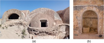
Despite these pressures, the monument remains of very high archaeological and architectural significance. Following the vegetation campaign in 2024, the team was able to regain access to the interior after efforts by the DoA to clear sand from one of the western entrances. This access made it possible to undertake a rapid condition assessment which revealed further causes for concern. Openings around the domes had been vandalised, creating points of entry into the building (Figure 10). Evidence of fire and damage to the painted walls, including graffiti, were observed inside the structure, indicating unauthorised use and underlining the urgent need to secure the monument and prevent further misuse.
The condition of the Hunting Baths at Lepcis Magna in 2024 (photographs by H. Alkhalaf).

Work at the Hunting Baths has proceeded along two closely connected lines: emergency protection and long-term environmental management. Survey work has focused on assessing the environmental conditions around the building. The sand accumulation, in general, is more influenced by the shoreline and geography than by wave action. The coastal morphology and the associated changes are controlled by the two headlands, one to the east and the other to the west. Sand stabilisation, therefore, was addressed in terms of the wider landscape processes that continue to threaten the site rather than treating the monument in isolation.
MaLiCH has been working with Humiston & Moore Engineers, experts in coastal systems and engineering, to design a sand barrier between the Justinianic wall in the east and the Wadi Rassaf to the west. This strategy builds on a previous proposal in 2009 by Marco Polo.Footnote 2 To ensure stability and sustainability, key factors in the new proposal include the sand barrier being adequately set back from the shoreline to allow it to stabilise and become vegetated, being of an appropriate height and gradient, using biodegradable fencing to enable sand to accumulate and planting it with common, local, coastal species whose roots will stabilise it.
The sand for the dune will come from around the baths, with ground penetrating radar clarifying the extent of the archaeology and coring characterising the sand and its depth. With the results of the new survey work, the designs for the dune will be finalised, sent out for tender, then implemented with the whole process documented and the outcomes monitored. With the sand around the Hunting Baths removed, condition assessments of the building and its interior will be undertaken and newly-commissioned doors and windows will secure the site. These actions are essential not only to mitigate the current risks to the monument but also to create the conditions necessary for future conservation intervention. Together, these measures form part of an ongoing, landscape-based conservation strategy aimed at securing the long-term protection of the Hunting Baths.
Reflections on the outcomes
The three Libyan sites allow a comparative reading of how an integrated heritage-management framework operates across contrasting site types: a living oasis town and two extensive coastal archaeological landscapes. They highlight differences in risk profiles, management needs and desirable conservation outcomes, while also revealing shared structural challenges.
From a management perspective, Ghadames represents a historic urban landscape in which architecture, water systems, palm groves and everyday social practices are tightly interdependent. Conservation work, thus, must address not only the mud-brick fabric and its vulnerability to moisture, erosion and structural fatigue, but also the maintenance of hydraulic infrastructure and the continuity of craft skills that sustain the built environment. Attribute-based mapping made these interdependencies visible by relating tangible elements (urban form, house typologies, irrigation channels) to intangible practices (seasonal occupation, gendered uses of space, ritual life) and existing management structures. This analytical step was central to preparing the UNESCO reports on the Desired State of Conservation for the Removal of the Property from the List of World Heritage in Danger (DSOCR) and the Retrospective Statement of Outstanding Universal Value (RSOUV), to selecting and rehabilitating the Dan Al-Alaay building as a visitor centre, and to targeting documentation and training towards particularly fragile domains such as Zanjafour wall painting and traditional building-material production. In Ghadames, therefore, effective heritage management is inseparable from supporting living knowledge systems and restoring routine cycles of repair.
Lepcis Magna and Sabratha, by contrast, are largely uninhabited archaeological sites where the principal challenges are environmental and structural. Both occupy exposed coastal settings, with monuments subject to marine processes, salt-laden winds, sand encroachment and increasingly dense vegetation (El-Shahat et al. Reference El-Shahat, Minas and Khomiara2014; Westley et al. Reference Westley, Andreou, El Safadi, Huigens, Nikolaus, Ortiz-Vazquez, Ray, Smith, Tews and Blue2023). Conflict has also had direct impacts, most notably the clashes in Sabratha in September 2017 that affected the theatre (Leone et al. Reference Leone, Wootton, Fenwick, Nebbia, Alkhalaf, Jorayev, Othman, Alhddad, Belzic and Emrage2020). The deterioration recorded during our 2023–24 survey, however, reflects prolonged reductions in maintenance and coastal erosion rather than isolated episodes of violence.
Work at these sites has followed a different sequence. UAV and photogrammetric survey were used to map topography and vegetation. This informed site-wide but selective manual removal and, at Sabratha, supported the reburial of vulnerable mosaics in the Baths of Regio VII. The emphasis is on preventive conservation at scale: reducing the negative impacts of vegetation, from root damage to fire risk, and restoring access for documentation and conservation efforts. It has created the conditions for planned specialist interventions while also engaging local communities in their heritage and improving their experience of the sites. In response they have joined in with preservation activities and been inspired by the new management interventions to collect and dispose of rubbish.
Across the three sites, the project has also reframed how damage is conceptualised in conflict-affected heritage management. Public and media attention often gravitates towards spectacular acts of destruction; the Libyan cases demonstrate that cumulative, indirect processes – suspended funding, interrupted maintenance cycles, vegetation colonisation, failing water systems, loss of skilled labour – can be just as harmful to both local values and the sites’ OUV. By treating these slow, systemic forms of deterioration as central rather than secondary, MaLiCH’s approach redirects attention from emergency ‘rescue’ of monuments to the re-establishment of maintenance routines, monitoring systems and climate-responsive management.
A further point emerging from the comparison concerns the translation of international frameworks into local practice. In Ghadames, UNESCO instruments, particularly the DSOCR and RSOUV, were not treated as external reporting obligations but as opportunities to structure local analysis around value, authenticity and integrity. The attribute-based matrix allowed local categories of meaning (for example, the social role of roof terraces or the cultural significance of women’s wall painting) to be articulated within UNESCO’s conceptual language. At Lepcis Magna and Sabratha, the same risk-based logic guided the design of vegetation-management campaigns, the documentation of areas following selective removal and the planning of future interventions, creating a more robust evidential base for State of Conservation reporting. In all three cases, communication outputs – site leaflets for Ghadames and passport-size brochures for Lepcis Magna and Sabratha – helped embed these frameworks in everyday management and visitor engagement.
Finally, the comparative analysis underlines the structural problem of long-term sustainability. In the short to medium term, MaLiCH shows that targeted external funding, combined with national and local partnerships, can catalyse substantial change. Ghadames has been removed from the World Heritage in Danger List and a historic house has been rehabilitated as a visitor centre. At Lepcis Magna and Sabratha, vegetation has been cleared over tens of thousands of square metres, new tools for documentation, training and interpretation have been created and interventions have been completed or are at an advanced stage of planning.
The durability of these achievements, however, depends upon their incorporation into domestic budgets, regulations and institutional routines. For Ghadames, this entails securing sustained support for the visitor centre, training programmes and craft-based livelihoods linked to heritage. For Lepcis Magna and Sabratha, it requires institutionalising periodic vegetation control, reburial and drainage maintenance as part of ordinary site operations rather than as occasional project-based campaigns. The three Libyan cases therefore point to a broader lesson for cultural-heritage management in protracted crises: integrated, risk-based approaches can be developed and tested through time-bound projects, but their transformative potential will only be realised when they are absorbed into the everyday infrastructure of care maintained by national institutions.
Conclusion
Methodologically, this article shows how an attribute-based, risk-led approach can bring documentation, analysis and intervention together within one coherent method. By relating tangible elements, intangible practices and management structures within a unified matrix aligned to UNESCO categories of value, authenticity and integrity, the approach moves beyond monument-centred inventories towards an understanding of heritage as a socio-environmental system requiring continuous care. The integration of digital tools, selective preventive measures and adaptive reuse within this framework shows how evidence production can directly inform prioritisation, intervention design and governance arrangements, while also supporting the preparation of UNESCO instruments such as the SOUV/RS and DSOCR.
In the Libyan context, this methodology proved particularly relevant. Across Ghadames, Lepcis Magna and Sabratha the principal threats were not only episodes of conflict damage but the cumulative effects of interrupted maintenance, the erosion of knowledge and failing management structures under conditions of institutional fragility and environmental stress. The project’s work illustrates how addressing these ‘slow’ processes through systematic documentation, locally-grounded capacity-building and preventive action can align on-the-ground practice with the evidentiary requirements of World Heritage reporting. The removal of Ghadames from the List of World Heritage in Danger in 2025, alongside measurable reductions in risk at the coastal archaeological sites, demonstrates how such an approach can translate into recognised conservation progress even in constrained circumstances.
This must be viewed against the backdrop of running a project in a country with such socio-political complexity as Libya. Milestones were delayed as a result of this, with slow money transfers being particularly problematic when supporting work in country. The difficulties of moving money when the country has been placed under economic sanctions is particularly noteworthy and requires higher levels of flexibility and resilience. Other options might be to find innovative solutions to such problems through greater collaboration between different sectors and countries.
More broadly, the Libyan experience speaks to ongoing debates in the heritage field. It highlights the limitations of emergency-oriented and monument-focused interventions in complex archaeological landscapes and reinforces the need for integrated approaches that combine ecological understanding, social practice and institutional capacity within conservation planning. It also underlines that progress towards removal from the In Danger List depends not only on technical improvements to fabric, but on demonstrating credible management systems and risk awareness within international decision-making processes. In this sense, MaLiCH offers a transferable model for heritage stewardship in contexts affected by protracted crisis, where building an ‘infrastructure of care’ may be as critical as the physical conservation of monuments themselves.
Acknowledgements
We would like to acknowledge the wider MaLiCH project team and collaborators in Libya, Egypt and the UK, whose engagement with the development and delivery of this work has been central to its success and has provided an important basis for the reflections presented in this article. We are particularly grateful to the Department of Antiquities (DoA) offices and site controllers at each project site, as well as the GCPDA, the Women’s Training Centre and Tamanhit for Heritage, for their contributions and collaboration. We also thank the ALIPH Foundation for its generous and sustained support.



 Open access

