INTRODUCTION
The land and water management strategies that fostered the development of complex societies in southern Mesoamerica are incompletely understood. For the ancient Maya, however, environmental and resource studies provide a unique lens through which to view the integrative social, political, and economic activities that characterized this resilient civilization for centuries prior to the Conquest period. The study of water management features of the Maya lowlands, in particular, has recently proved invaluable in revealing some of the complex human-environment relationships of the Late Preclassic (400 b.c.–a.d. 150) and Classic (a.d. 250–950) period Maya. The interior portions of the lowlands in Mexico, Guatemala, and Belize were particularly challenging environments for ancient occupation, owing to a porous limestone (karst) landscape, a general lack of permanent surface water, and an acute five-month annual dry season. These conditions combined to necessitate the seasonal collection and storage of rainwater not only for survival, but also for domestic, agricultural, and ritual activities across multiple societal levels.
Our knowledge of ancient Maya water management is derived from numerous survey and excavation projects undertaken throughout the lowlands that have analyzed a variety of hydrologic features such as reservoirs, seasonally inundated wetlands (bajos), canals, dams, wells, natural sinkholes resulting from the collapse of limestone bedrock (cenotes), and small underground water cisterns (chultuns) in an archaeological context (e.g., Akpinar-Farrand et al. Reference Akpinar-Ferrand, Dunning, Lentz and Jones2012; Beach and Dunning Reference Beach and Dunning1997; Brewer Reference Brewer2007; Bullard Reference Bullard1960; Chmilar Reference Chmilar2005; Davis-Salazar Reference Davis-Salazar2003; Dunning et al. Reference Dunning, Scarborough, Valdez, Luzzadder-Beach, Beach and Jones1999; Harrison Reference Harrison, Scarborough and Isaac1993; Isendahl Reference Isendahl2011; Johnston Reference Johnston2004; Lohse and Findlay Reference Lohse and Findlay2000; Matheny Reference Matheny1976, Reference Matheny, Harrison and Turner1978, Reference Matheny and Flannery1982; Scarborough Reference Scarborough and Schiffer1991, Reference Scarborough1994, Reference Scarborough and Fedick1996, Reference Scarborough2003; Scarborough and Gallopin Reference Scarborough and Gallopin1991; Scarborough et al. Reference Scarborough, Becher, Baker, Harris and Valdez1995; Weiss-Krejci Reference Weiss-Krejci2013; Weiss-Krejci and Sabbas Reference Weiss-Krejci and Sabbas2002; Wyatt Reference Wyatt2014). Collectively, they provide many insights into the creation and maintenance of these features, as well as their use by the ancient Maya. As scientists continue to study the multifaceted components of Maya water management, it is becoming increasingly evident that these ancient systems were complex, varied, and far from uniformly distributed across the Maya world. The complexities of Maya water management continue to be explored through a number of broader applications, including within the contexts of landscape modifications (Dunning et al. Reference Dunning, Scarborough, Valdez, Luzzadder-Beach, Beach and Jones1999), critical resource control (Ford Reference Ford and Fedick1996), paleoecology (Dunning and Beach Reference Dunning, Beach, Martini and Chesworth2010; Johnston et al. Reference Johnston, Breckenridge and Hansen2001; Wahl et al. Reference Wahl, Schreiner, Byrne and Hansen2007), social and environmental changes (Beach et al. Reference Beach, Luzzadder-Beach, Cook, Dunning, Kennett, Krause, Terry, Trein and Valdez2015a; Dunning et al. Reference Dunning, Beach, Sierra, Jones, Lentz, Luzzadder-Beach, Scarborough and Smyth2013; Kunen Reference Kunen2004; Lucero et al. Reference Lucero, Gunn and Scarborough2011); political control and political economy (Lucero Reference Lucero, Bacus and Lucero1999, Reference Lucero2002, Reference Lucero2006); population estimates and architectural variability (Becquelin and Michelet Reference Becquelin and Michelet1994; McAnany Reference McAnany, Culbert and Rice1990); and satellite imagery and remote sensing analyses (Chase Reference Chase2016; Chase and Weishampel Reference Chase and Weishampel2016; Garrison Reference Garrison2010; Saturno et al. Reference Saturno, Sever, Irwin, Howell, Garrison, Wiseman and El-Baz2007; Weller Reference Weller, Campana and Forte2006).
At both the community and household levels, aguadas—either natural or human-made ponds that still retain water for at least a portion of the year—and topographical depressions that functioned as seasonal reservoirs served as significant sources of water for the region's inhabitants. Naturally occurring depressions originate from collapse or dissolution sinkholes that are usually found at the margins of bajos and along bedrock fractures in karst uplands (Akpinar-Ferrand et al. Reference Akpinar-Ferrand, Dunning, Lentz and Jones2012; Siemens Reference Siemens, Harrison and Turner1978). Many natural depressions in the vicinity of ancient Maya settlements were found to have been lined with clay, lime plaster, and/or stone facing to enhance their ability to retain water (Adams and Jones Reference Adams and Jones1981; Akpinar-Ferrand Reference Akpinar-Ferrand, Dunning, Lentz and Jones2012; Brewer Reference Brewer2007; Wahl et al. Reference Wahl, Schreiner, Byrne and Hansen2007; Weiss-Krejci and Sabbas Reference Weiss-Krejci and Sabbas2002). Both communal and residential reservoirs (tanks), however, could also evolve from human-modified depressions such as ancient limestone, clay, or chert quarries that were later transformed to store water (Bullard Reference Bullard1960; Dunning et al. Reference Dunning, Akpinar, Carr, Griffin, Jones, Lentz, Miller, Prater, Urquizú and Saturno2007; Hester and Shafer Reference Hester and Shafer1984; Weiss-Krejci and Sabbas Reference Weiss-Krejci and Sabbas2002). These modified features are particularly evident in the Puuc region of the northern Yucatan, where numerous depression reservoirs have been recorded in relation to ancient settlement (Dunning et al. Reference Dunning, Wahl, Beach, Jones, Luzzadder-Beach, McCane and Iannone2012; Isendahl Reference Isendahl2011). As will be detailed below, the combined effects of the karst hydrology of the Maya lowlands, a lack of permanent natural water sources, and the seasonality of available precipitation necessitated collection and storage of rainwater, a system in which aguadas and small reservoirs likely played a necessary and substantial role in the daily lives of the ancient Maya.
In addition to broadening our understanding of water management activities, the careful study of small-scale water management features provides an opportunity to gather important information about human-environment interactions in the Maya area. To fully understand their origin and functions, an interdisciplinary, multi-scale approach incorporating archaeology, climatology, hydrology, geology, and remote sensing is necessary. For example, the record of pollen and other materials preserved within aguada sediments permits archaeologists and paleoecologists seeking to decipher the history of land use and environmental change in the Maya area important, highly localized glimpses of these past landscapes (Dunning and Beach Reference Dunning, Beach, Martini and Chesworth2010). Satellite imagery and remote sensing technology in concert with landscape archaeology approaches have recently been employed in the Maya area to investigate landscape modifications and answer questions relating to settlement, subsistence, and population by correlating spectral vegetation signatures with locations, boundaries, and dimensions of Maya sites (Chase Reference Chase2016; Chase and Weishampel Reference Chase and Weishampel2016; Chase et al. Reference Chase, Chase, Weishampel, Drake, Shrestha, Slatton, Awe and Carter2011; Saturno et al. Reference Saturno, Sever, Irwin, Howell, Garrison, Wiseman and El-Baz2007; Weller Reference Weller, Campana and Forte2006). Archaeologists in the Maya area have long reported a spatial correlation between reservoirs and ancient settlement (Adams Reference Adams1991; Bullard Reference Bullard1960; Folan et al. Reference Folan, Marcus, Pincemin, Carrasco, Fletcher and Lopez1995; Morley Reference Morley1937; Scarborough Reference Scarborough, Scarborough and Isaac1993; Smith Reference Smith1950). Despite this recognition, however, it wasn't until the 1980s that scientific investigations began to focus directly on and around these features (e.g., Domínguez Carrasco and Folan Reference Domínguez Carrasco, Folan, Laporte and Escobedo1996; Dunning et al. Reference Dunning, Jones, Beach, Luzzadder-Beach, Scarborough, Valdez and Dunning2003; Scarborough et al. Reference Scarborough, Becher, Baker, Harris and Valdez1995; Wahl et al. Reference Wahl, Schreiner, Byrne and Hansen2007). The vast majority of research on these reservoirs has examined them within the context of centralized, elite-controlled construction, maintenance, access, and water distribution with data from large sites such as La Milpa (Scarborough et al. Reference Scarborough, Becher, Baker, Harris and Valdez1995) and Tikal (Scarborough Reference Scarborough2003; Scarborough and Gallopin Reference Scarborough and Gallopin1991; Scarborough et al. Reference Scarborough, Dunning, Tankersley, Carr, Weaver, Grazioso, Lane, Jones, Buttles, Valdez and Lentz2012) forming the basis of much of our knowledge on their construction and use-histories. Recently, however, as part of a general shift toward understanding the rich diversity that characterized the social and environmental activities, economic independence, and daily practices of non-elites or “commoners” has taken place in Maya studies, a more complex and dynamic picture of water management activities at the household scale has begun to emerge.
This article discusses the results of decentralized, domestic-scale water management investigations from two central lowland sites: the hinterland agricultural community of Medicinal Trail in northwestern Belize and the urban center of Yaxnohcah in southern Campeche, Mexico. Research included a single reservoir and additional water features associated with two residential courtyard groups investigated at Medicinal Trail and a series of four reservoirs associated with residential structures throughout Yaxnohcah. An interdisciplinary approach consisting of landscape survey, excavation, and material analysis of collected cultural material was undertaken in order to understand the household water management practices of these two sites, especially reliance on small household tanks operating separately from the larger, centralized, elite-controlled reservoirs.
STUDY AREA
The Maya lowlands region, divided into northern, central, and southern segments, as defined by Hammond and Ashmore (Reference Hammond, Ashmore and Ashmore1981), is both a cultural and physical region characterized by a series of related cultures that have occupied this area of generally low-lying, limestone terrain with a tropical wet/dry climate (Beach et al. Reference Beach, Dunning, Luzzadder-Beach, Cook and Lohse2006). Evidence of Maya culture and its impacts on the environment date from the Early Preclassic period (2000–1000 b.c.) and have lasted, with significant ebbs and flows, to the present (Brenner et al. Reference Brenner, Hodell, Curtis, Rosenmeier, Anselmetti, Ariztegui, Gomez-Pompa, Allen, Fedick and Jimenez-Osomio2003; Pohl et al. Reference Pohl, Pope, Jones, Jacob, Piperno, deFrance, Lentz, Gifford, Danforth and Josserand1996). Within the region, environmental and geological factors that create a variety of habitats include fluctuations in intra- and inter-annual rainfall, soil and geomorphic processes, and slope gradients and drainage based on structural geology (Beach et al. Reference Beach, Dunning, Luzzadder-Beach, Cook and Lohse2008; Dunning et al. Reference Dunning, Beach, Farrell and Luzzadder-Beach1998).
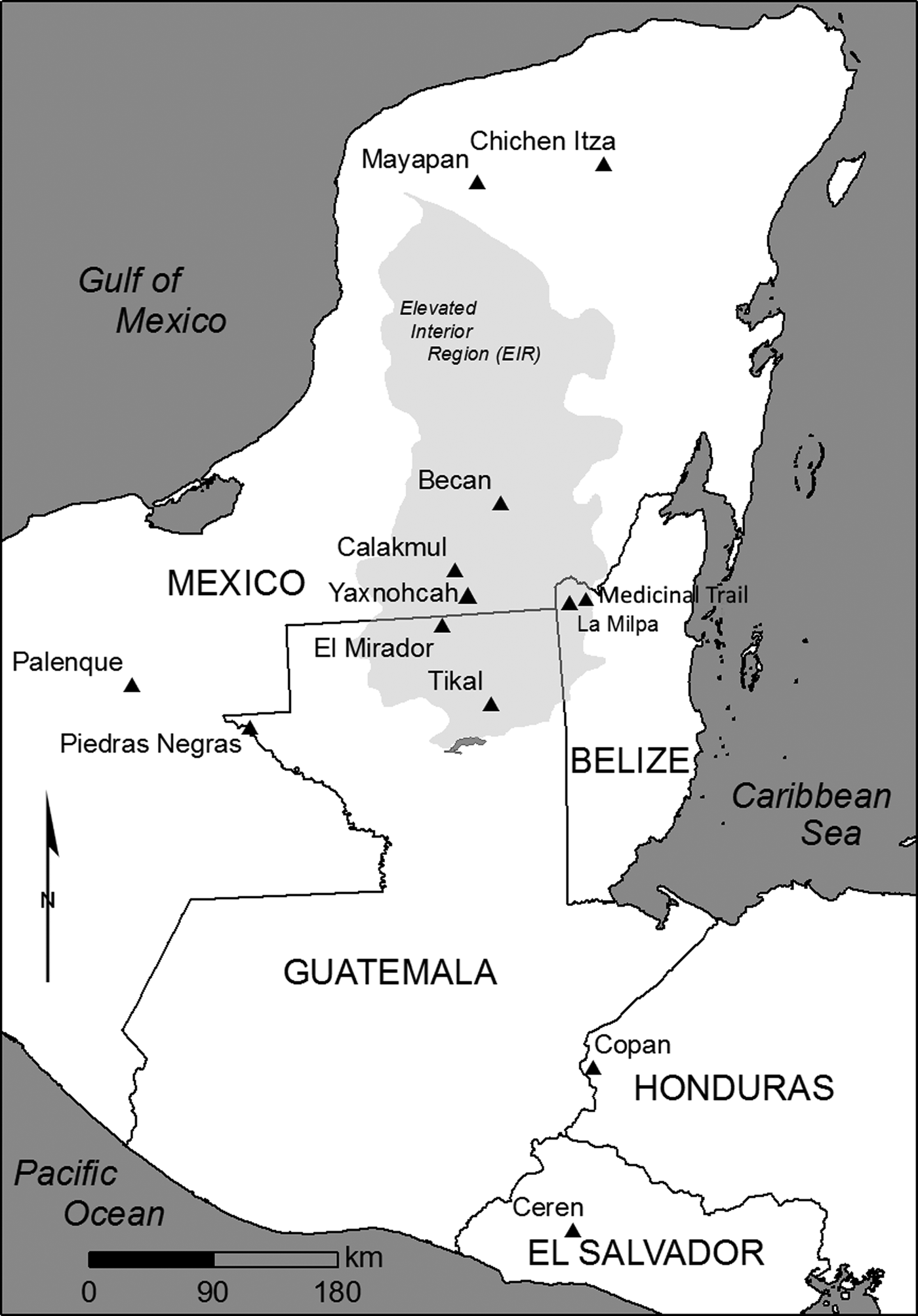
The study area in which the two investigated sites are located is defined by a slightly variable physical geography (Figure 1). Medicinal Trail is located roughly five kilometers east of the major site of La Milpa in northwestern Belize, along the eastern edge of the Elevated Interior Region (or Central Karst Uplands) of the Yucatán Peninsula (Dunning et al. Reference Dunning, Wahl, Beach, Jones, Luzzadder-Beach, McCane and Iannone2012) and within the Programme for Belize (PfB) conservation area, a 1,000 km2 ecological reserve located within the greater Three Rivers Region (Scarborough and Valdez Reference Scarborough, Valdez, Scarborough, Valdez and Dunning2003). Long-term investigations undertaken within and in the immediate vicinity of the PfB boundaries have produced valuable information about occupation and land use of this region from the Middle Preclassic (600–400 b.c.) to the Late Classic periods (a.d. 650–900), with a particular focus on small sites or communities and their relationship to the environment (Adams et al. Reference Adams, Scarborough, Levi, Walling, Dunning, Lewis, Shaw, King, Sullivan, Reese-Taylor, Valdez, Awe, Morris and Jones2004; Adams and Valdez Reference Adams and Valdez1993; Beach et al. Reference Beach, Luzzadder-Beach, Dunning, Hageman and Lohse2002; Guderjan Reference Guderjan2007; Hammond et al. Reference Hammond, Tourtellot, Donaghey and Clarke1998; Houk Reference Houk2000; Lohse et al. Reference Lohse, Barrera, Padilla, Lohse and Sagebiel2005). The hinterland site of Medicinal Trail is part of the La Lucha Uplands within the Three Rivers physiographic region, an area comprising the fractured eastern side of the central Peten Karst Plateau and heavily influenced by extensive normal faulting (Dunning and Beach Reference Dunning, Beach, Martini and Chesworth2010; Dunning et al. Reference Dunning, Scarborough, Valdez, Luzzadder-Beach, Beach and Jones1999, Reference Dunning and Beach2003). The region is underlain by Late Cretaceous–Early Tertiary marine carbonates, primarily marl and chert-containing limestone. The well-developed contemporary karst landscape, characterized by large solution depressions (bajos), rugged ridges, and conical hills, is the result of extensive, long-term physical and chemical weathering of carbonate bedrock (Dunning et al. Reference Dunning, Beach, Farrell and Luzzadder-Beach1998, Reference Dunning and Beach2003). Like elsewhere in the central lowlands, annual rainfall in the region today varies between 1,400 and 1,800 millimeters (National Meteorological Service of Belize, Rio Bravo Station). The geological and climatic characteristics of the area lead to significant variation in hydrology, soils, and vegetation types. The sloping, well-drained landscapes of the La Lucha Uplands are usually mantled in thin, calcareous soils (rendolls) that support an “upland forest” mixture of subtropical moist forest species (Dunning et al. Reference Dunning and Beach2003).
Map of the Maya region showing Medicinal Trail and Yaxnohcah. Both sites are located in the elevated interior region of the Yucatan peninsula. Map by author.

Yaxnohcah is located within the Calakmul Biosphere Reserve, part of the 533,000 km2 Mesoamerican Biological Corridor linking protected natural areas of Mexico, Guatemala, Belize, El Salvador, Nicaragua, Honduras, Costa Rica, and Panama under the mission of preserving and protecting the biodiversity of the rainforest (Geovannini Acuña Reference Geovannini Acuña, Reese-Taylor and Hernández2013). Like Medicinal Trail, the site lies within the Elevated Interior Region. Although this region was the heartland of much of both Preclassic and Classic Maya civilization, it is also an area with severe environmental challenges. In particular, the lack of perennial surface water during the lengthy winter–spring dry season, accentuated by a deep and largely inaccessible karst groundwater system, posed a significant problem for year-round occupation. Across the region, large bajos occupy as much as 40–60 percent of the land surface. At present, these large depressions are characterized by severe moisture fluctuation ranging from inundation in the wet season to complete desiccation in the dry. Yaxnohcah is situated on the southern flank of Bajo El Laberinto, one of the largest bajos in the Maya lowlands. Previous investigations within the bajo interior revealed highly gypsic or acidic soils that would have been unproductive for agricultural uses (Gunn et al. Reference Gunn, Folan, Domínguez-Carrazco and Faust2002). The margins of the bajo, however, where soils have developed in calcareous colluvium derived from the adjacent uplands, would potentially have been highly productive sites for cultivation (Dunning et al. Reference Dunning, Beach, Luzzadder-Beach, Lucero and Fash2006; Geovannini Acuña Reference Geovannini Acuña2008). Shallow soils (lithosols) predominate in the hills and upper elevations of the site, while vertisols and other hyromorphic soils are found in the depressions and lower-lying areas. Vegetation consists of a mixture of bajo, transitional, and upland semi-deciduous subtropical forest. Some of the principal species observed in the upland forest include: chicozapote (Manilkara zapota), ramón (Brosimum alicastrum), chakah (Bursera simaruba), sapotillo (Pouteria reticulate), and pimiento (Pimenta dioica). In the bajo, dominant species consist of: palo tinto (Haematoxylum campechanum), chaká (Bursera simaruba), guayabillo (Eugenia capuli), and zapote (Manikara zapota), in addition to a variety of bromeliads, orchids, and creeping vines (Geovannini Acuña Reference Geovannini Acuña, Reese-Taylor and Hernández2013). In addition, the Calakmul Reserve is home to over 1,500 species of animals, including jaguar, puma, ocelot, and many types of mammals, birds, reptiles, and fish.
THE HYDROLOGIC LANDSCAPE OF MEDICINAL TRAIL
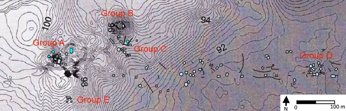
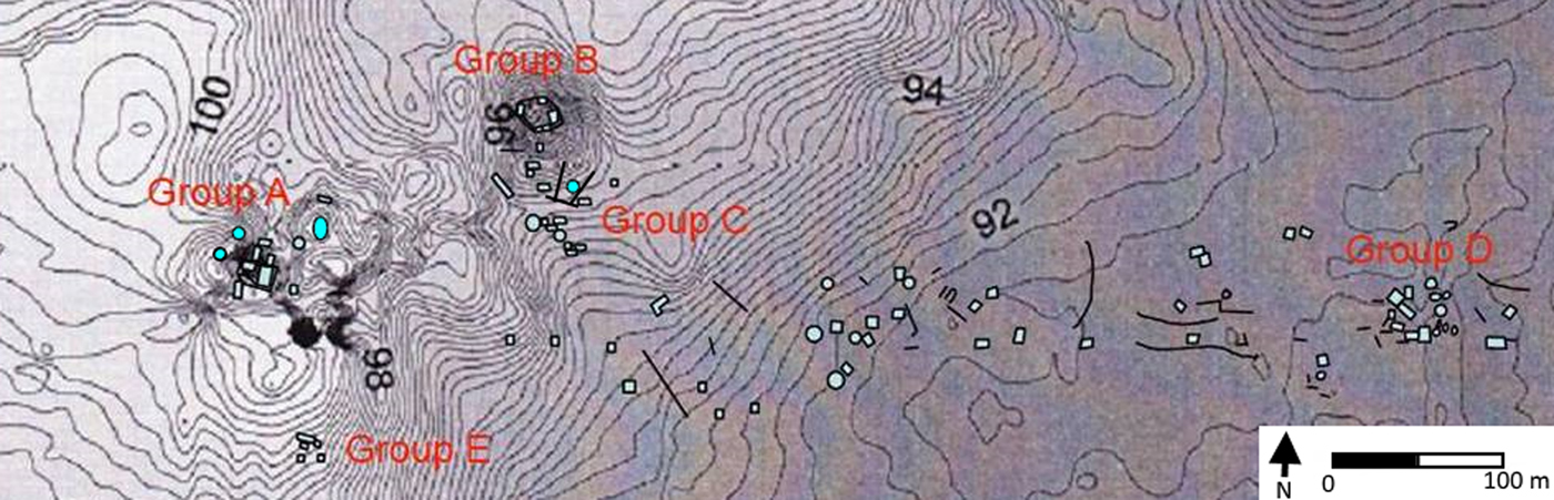
Medicinal Trail (UTM coordinates: 16Q 286600 1973379) extends from the Turtle Pond Aguada that defines its western margin to the escarpment on its east (Figure 2). The site name is derived from the PfB's tourist attraction called the “Medicinal Trail,” a proposed eco-tourism tract populated by vegetative species with a variety of native healing applications. Scarborough and Valdez (Reference Scarborough, Valdez, Scarborough, Valdez and Dunning2003, Reference Scarborough and Valdez2009) define it as a small “resource-specialized community”—a highly interdependent settlement established on the economic benefits of unique sets of goods and services differentiating one community from another—focused on agricultural production and engaged in the communal management of water resources. Initial excavations at the site consisted of two separate studies that investigated mounds and terraces that cross the trail from which the site gets its name (Farnand Reference Farnand2002; Ferries Reference Ferries2002). Two seasons later, excavations took place at Turtle Pond, a large aguada at the base of a slope on the western edge of the site (Chmilar Reference Chmilar2005). The extensive capacity of the tank, 785 m3, suggests a function exceeding the household level, possibly even providing access beyond the boundaries of the community itself (Scarborough and Valdez Reference Scarborough and Valdez2009). Subsequent field seasons have revealed at least two closely associated formal courtyard groups, a number of informal mound clusters, and multiple landscape modifications including agricultural terraces and depressions and linear features with apparent residential scale water management functions (Brewer et al. Reference Brewer, Hyde, Stowe and Valdez2013; Gill Reference Gill, Trachman and Valdez2009; Hyde Reference Hyde2011; Lowe Reference Lowe2008; Percy Reference Percy, Trachman and Valdez2009).
Medicinal Trail site map showing structure groups discussed in the text. Contour interval is 50 cm. Adapted from Brewer et al. (Reference Brewer, Hyde, Stowe and Valdez2013).
Medicinal Trail Reservoir (Operation 10)
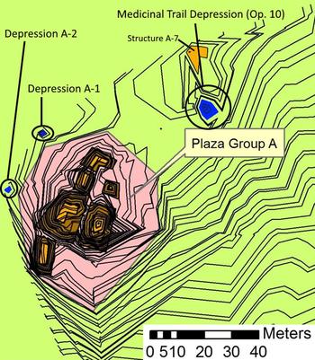
The Medicinal Trail Reservoir, designated Depression A-3, is located adjacent to Group A, the largest settlement group identified at the site (Figure 3). Defined as a First Tier Household, a formal courtyard group composed of multiple structures with complex basal platforms, Group A consists of six mounds organized around three contiguous courtyards with the largest construction placed on the east side of the group (Hageman and Lohse Reference Hageman, Lohse, Scarborough, Valdez and Dunning2003; Hyde and Atwood Reference Hyde, Atwood and Valdez2008; Hyde and Valdez Reference Hyde, Valdez and Valdez2007). The depression itself is situated 40 m northeast of the center of Group A and fewer than 10 meters south of Structure A-7, and is roughly ellipsoidal in shape. Initial support for Depression A-3 serving as a water tank was based on its surface area, estimated capacity, and location adjacent to a probable residential structure (Structure 7). The shape, potential volume (accounting for sedimentation and soil formation over time), and calculated surface area fit the profile of other topographical depressions investigated as water resources in the central Maya lowlands (Weiss-Krejci and Sabbas Reference Weiss-Krejci and Sabbas2002). In addition, the proximity of the depression to several agricultural terraces and additional house mounds, coupled with the absence of any permanent water sources in the immediate vicinity, suggest its function as a principle source of water for neighboring residents.
Map of Group A at Medicinal Trail. The Medicinal Trail Reservoir (Operation 10) is shown in the upper right. Depressions A-1 and A-2 were investigated by Lowe (Reference Lowe2008). Contour interval is 15 cm. Adapted from Stowe and Hyde (Reference Stowe, Hyde and Valdez2014).

Numerous small aguadas or small reservoirs in the immediate area of household plots or house mounds throughout the lowlands have been noted (Bullard Reference Bullard1960; Matheny Reference Matheny1976; Scarborough Reference Scarborough, Scarborough and Isaac1993, Reference Scarborough1998). Bullard (Reference Bullard1960:364), in connection with his survey in the northeastern Peten, initially reported that “there is a marked tendency for these house ruins to occur in the vicinities of present-day, and possibly former, water sources…It is my impression that the maximum distance from a water source was probably less than two kilometers.” Scarborough (Reference Scarborough, Scarborough and Isaac1993) also points out the importance of households situating themselves as close to a water source as possible, highlighting the competitive aspects of neighboring households and a finite water supply. This spatial relationship between habitation structures and water features has recently been confirmed in the central lowlands at sites in proximity to Medicinal Trail, such as La Milpa, Dos Barbaras, and Wari Camp (Scarborough et al. Reference Scarborough, Becher, Baker, Harris and Valdez1995; Weiss-Krejci and Sabbas Reference Weiss-Krejci and Sabbas2002). The structures nearest the Medicinal Trail Reservoir fall well within this 2 km radius.
The primary goal of the Depression A-3 excavations was to clarify the role of this feature as a potential water resource and demonstrate its use history. A secondary goal was to gain a better general understanding of the role that household tanks played in the daily lives of ancient Maya people, particularly those within a decentralized or hinterland context outside of large urban centers. The earliest occupation evidence in the vicinity of the Medicinal Trail Reservoir dates to the Late Preclassic (400 b.c.–a.d. 100) and derives from house mound and courtyard excavations in Group A (Hyde Reference Hyde, Trachman and Valdez2009). Excavations began under the assumption that the reservoir would also have been in operation during this period.
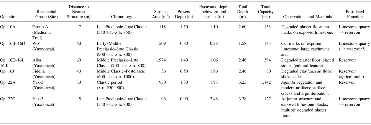
The depression was excavated to sterile sascab (calcareous marl) and all recovered cultural material was assessed and catalogued by the project ceramicist and lithicist (Hyde Reference Hyde2007). Ceramic material was assigned a preliminary date (if possible) based on the chronologic ceramic typology being developed for Medicinal Trail. These data would prove useful in establishing a date range for the active lifespan of the feature, as well as potentially drawing a parallel between its use and the occupation of nearby residential complexes. Total reservoir capacity for Depression A-3 (and all other reservoirs investigated in this study), based on their combined current and maximum excavated depths, was estimated by taking the formula for an elliptical cone, H (1/3) × π (A/2) × (B/2), where H is the height and A and B are the length and width, respectively, and modifying it to accommodate the fact that smaller reservoirs tend to be more spherical in shape. The derived formula, H (1/2) × π (A/2) × (B/2), employs a constant (1/2) that is halfway between the constants of the formulas for a cone (1/3) and a hemisphere (2/3), and was used to calculate the volume of the reservoirs studied at Medicinal Trail and Yaxnohcah (Brewer Reference Brewer2007). The result was a volume of over 153 m3 (153,000 liters, or over 40,000 gallons), which would have provided over 80,000 person/day servings maximum (Table 1). McAnany's (Reference McAnany, Culbert and Rice1990) extremely conservative standard of 1.9 L (0.5 gallons, based on eight 8 oz servings per day) of water per person per day has been debated, with a more recent estimate of 17 L (4.5 gallons per person per day) applied to the site of Xculoc (Becquelin and Michelet Reference Becquelin and Michelet1994). This figure, based on a detailed survey of contemporary consumer groups occupying the village, is derived from a combination of individual daily consumption and a calculated supply of renewable (wells) and non-renewable dry season water reserves (cisterns and reservoirs). With generous allowances for laundry and additional non-potable uses this estimate is likely liberal, with the actual ancient Maya dry season water use probably falling somewhere in between. As a compromise, an estimate halfway between these two figures (9.5 L per person per day) was used to calculate the maximum person/day servings in order to project a localized support population for the Medicinal Trail tank as a source of potable water. A full reservoir, then, with no evaporation could provide over 43 people with enough drinking water each day for one year. This figure would undoubtedly be reduced when taking evaporation rates and additional agricultural and domestic water uses, such as cooking and washing, into account. Nonetheless, the reservoir would have served as a reliable water source for residents in this area of the community.
Data summary and evaluation of all reservoirs investigated by the author.

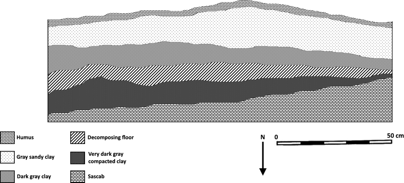
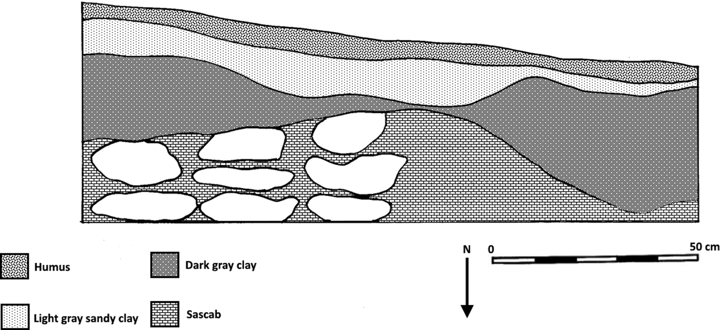
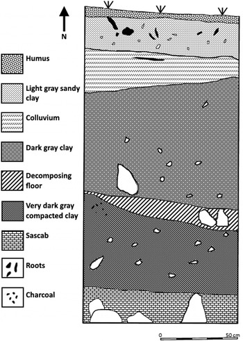
The presence of a degraded plaster floor located between a layer of clayey reservoir sediment and a lower, clay-rich (Ab) horizon atop sascab is another positive indicator that the depression functioned as a water storage feature. Though sometimes difficult to differentiate from in-washing clay sediment, the degraded remains of this floor were encountered in multiple units throughout the depression roughly 25–35 centimeters below the surface and interpreted in the field as the remains of a relatively impervious sealant (Figure 4). The limestone bedrock underlying the depression is highly permeable and either natural or artificial modification would have been necessary to retard leakage. Weiss-Krejci and Sabbas (Reference Weiss-Krejci and Sabbas2002) report the presence of a similar hard gray layer, between 10 and 30 centimeters thick, overlaying white, medium-hard, smooth bedrock at four excavated depressions near the neighboring Wari Camp and La Milpa East sites that they interpret as small water reservoirs. Similarly, the large, extensively excavated La Milpa Aguada was subjected to extensive quarrying and contained a huge berm or dam on the western side that created or enhanced its capacity. A small stone-lined well (bukte) that functioned to extract water from surrounding saturated clay, originally Late Classic before being reopened in the Terminal Classic/Early Postclassic, was also discovered within the bottom of the reservoir. Core samples collected from the base of the aguada revealed a kaolin clay lining of either natural or unnatural origin (Scarborough et al. Reference Scarborough, Becher, Baker, Harris and Valdez1995). Further evidence of the Maya practicing these simple, yet practical modifications has also been noted in multiple aguadas at Calakmul (Folan et al. Reference Folan, Marcus, Pincemin, Carrasco, Fletcher and Lopez1995), Uaxactún (Smith Reference Smith1950:61, Figure 99b), and near Dos Hombres (Trachman Reference Trachman2007). Within Depression A-3, a layer of in-washing clay sediment overlays the sascab base of the feature. Atop this, the highly degraded floor composed of compacted clay with sascab rubble intermixed lies beneath additional reservoir sediment and modern soil.
South profile drawing of Operations 10Q, 10R, 10Y, and 10Z at the Medicinal Trail Reservoir, showing the remnants of a heavily weathered floor. Drawing by author.

Bedrock at the base of each excavation unit was examined for evidence of quarrying activities and the possible presence of a water-retention or otherwise culturally modified “wall” or a channel that would have permitted the flow of water into and out of the reservoir. Small depressions elsewhere in the Maya lowlands have been interpreted as rock quarries, sascaberas (sascab mines), and clay mines (Folan Reference Folan1982; Tourtellot and Rose Reference Tourtellot and Rose1993). The notion that small water tanks originating as natural depressions also served as quarries for building material before being modified to store water bears further examination and is also being considered in water management investigations elsewhere in the Maya lowlands (Weiss-Krejci and Sabbas Reference Weiss-Krejci and Sabbas2002; Brewer et al. Reference Brewer, Carr, Dunning, Walker, Hernández, Peuramaki-Brown and Reese-Taylor2017). Most of the bedrock within Depression A-3 appeared to be naturally decomposing and exhibited no conclusive evidence of quarrying, with the exception of visible cut marks and flattened edges on the limestone revealed at the base of Operation 10J. This discovery, combined with a lithic inventory consisting of multiple tools (n = 57), including at least one intact mid-sized biface, supports the notion that quarrying activities may well have been taking place within the depression at some time during its use history. Based in part on experimental archaeological research conducted at the site of Nakbe, a variety of stone tools composed of chert, including bifacial axes, picks, and hammer stones, have been demonstrated to be excellent tools for mining, cutting, and shaping limestone (Hansen Reference Hansen and Houston1998). The stone tools recovered from Depression A-3 were generally poor to very poor in quality and, with the exception of a single chalcedony scraper, composed entirely of chert. Biface tools comprise over half of the tool assemblage (n = 30), more than half of which are forms related to agriculture (oval bifaces and bifacial celts). Informal and expedient tools, including scrapers and utilized flakes, account for the remaining majority (n = 13) of the remaining tool assemblage. The overall lithic assemblage from the depression is best characterized as being dominated by low-quality chert material used to produce bifaces for local consumption, agriculture, and limestone quarrying (Hyde Reference Hyde2007).
Recovered ceramic material included a wide variety of rims and body sherds, basal flanges, and a single eroded vessel base with a broken mammiform foot. The majority of sherds from inside the depression, deriving from all operations except seven of the posthole units initiated around the perimeter of the feature, were eroded and only a portion could be stylistically dated. It is likely that the Maya employed ceramic materials in the course of utilizing the reservoir but most of this material is either too small, too heavily eroded, or has disintegrated entirely due to the continuous exposure to water and pressure. With the exception of a few rim forms and ring bases that belong to the Chicanel phase (Late Preclassic period, 350 b.c.–a.d. 250), the majority of recovered ceramic material dates between the Tzakol (Early Classic, a.d. 250–550) and Tepeu I/II (Late Classic, a.d. 550–850) complexes. This range of forms, phases, and dates correlates strongly to other ceramic artifacts recovered in the vicinity of the depression (Hyde Reference Hyde2011). Ceramics recovered from Group A clearly indicate an occupation from at least the Late Preclassic through the Terminal Classic, with a likely Middle Preclassic presence.
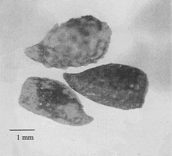
The analysis of recovered soil samples provides additional support for the depression functioning as a reservoir. In an attempt to reconstruct the types of vegetation immediately surrounding the depression through organic or botanical remains, a 1.5-L soil sample was collected from Operation 10C at a depth of 67 cm below the surface. The sample was floated for micro- and macro- plant remains using a Flote-Tech model A-1 machine in the anthropology lab at Northern Illinois University. After the samples were air dried, they were passed through a standard series of graduated sieves (4.0–0.425-mm mesh) for better viewing. Overall, the sample consisted of small limestone chunks and hard clays, with a number of small pieces of heavily eroded wood charcoal suspended in the matrix. A single palm seed fragment, tentatively identified as Arecaceae sp., was recovered. Palms were used and tended by the ancient Maya in and around settlements, and continue to be grown and harvested by their modern descendants (Darch Reference Darch, Turner and Harrison1983; Dunning and Beach Reference Dunning and Beach2003). In addition, a total of nine seeds determined to be from the Onagraceae family (possibly of the Oenothera genus) were identified from the sample (Figure 5). These are seeds from a plant currently being investigated as part of the evening primrose family, and samples have been recovered from several other sites in the PfB area, including Blue Creek, the Barba Group, and Guijarral (Hageman and Goldstein Reference Hageman and Goldstein2009). Although its exact significance or relationship to human activity in this time period is unclear, it has been found in conjunction with both domestic and feasting loci and its presence appears to be an indicator of human presence and activity (Goldstein and Brandt Reference Goldstein and Brandt2007; Goldstein and Hageman Reference Goldstein, Hageman, Staller and Carrasco2010).
Image of Onagraceae seeds recovered from the Medicinal Trail Reservoir. Image from Goldstein and Brandt (Reference Goldstein and Brandt2007).

Ultimately, Depression A-3 was determined to have originated as a quarry before functioning as a domestic-scale reservoir based on a wealth of recovered physical and cultural data. The depression's surface area and calculated capacity, the presence of a degraded clay sealant overlaying the bedrock, and its association with a large formal household group all support its role as a water storage feature. Analysis of recovered ceramic material revealed that the reservoir was in use contemporaneously with occupation of the adjacent structures, lending further support for its importance to the community's inhabitants. Environmental indicators in the form of recovered palm seeds provide additional evidence of human activity around the depression.
Additional Household Water Management Infrastructure at Medicinal Trail
Initial excavations at Medicinal Trail consisted of two studies that investigated mounds (Ferries Reference Ferries2002) and terraces (Farnand Reference Farnand2002) that cross the main trail through the site. Prehistoric terraces are common features of Maya archaeological landscapes and have often been used to define agricultural production areas. These features do not invariably delineate arable land, however, and other uses, such as providing foundations for structures or managing the flow of water, have also been hypothesized. Terraces at Medicinal Trail were studied with the goal of understanding their formation processes and possible role in water management. Farnand determined that each of the terraces investigated were used for a unique purpose, including agricultural, structural, and possibly even territorial functions. Of the four alignments studied, one (Alignment 1) was determined to support a large terrace extending upslope into land that would be optimal for cultivation. A second terrace (Alignment 3) is believed to have served either as an agricultural terrace or a property boundary marker. Alignment 4 is a structural terrace directly joining another contour terrace upslope. The fourth terrace (Alignment 2), however, may well have served in a water management capacity. Like Alignment 1, it supports a large terrace that extends upslope. If subjected to higher erosional rates, however, it is possible that it would not have been able to sustain agricultural activity and may have instead aided in erosion prevention or water diversion (Farnand Reference Farnand2002). If so, this feature might have functioned as a check dam or weir terrace (Beach et al. Reference Beach, Luzzadder-Beach, Dunning, Hageman and Lohse2002; Dunning and Beach Reference Dunning and Beach1994), acting to restrict the flow of water and create land for cultivation, both reasonable assumptions for this agrarian community.
More recently, excavations seeking evidence of water management modifications (Lowe Reference Lowe2008) took place within two small depressions on the west side of Group A, roughly 15 meters west-northwest of the northern courtyard (Depression A-1) and 15 meters west of the middle courtyard (Depression A-2) of the group. After testing both depressions to determine their nature and function, Lowe concluded that neither feature served as a reservoir. Both were small and shallow, with total surface areas of 38 m2 (Depression A-1) and 40 m2 (Depression A-2) and catchment areas that were difficult to identify or assess. Both features also lacked a distinct clay or other seal that would have aided in water retention. Ultimately, Depression A-1 was determined to be an unmodified natural feature of the landscape, possibly the result of a tree fall, and Depression A-2 appears to be the result of a natural depression being modified and expanded into a small limestone quarry. Although Lowe dismissed Depression A-2 as a reservoir given the lack of physical or cultural evidence, if it did retain water in some capacity following quarrying activities, this small tank would have offered a convenient supplemental, probably non-potable, water source for the inhabitants of Group A.
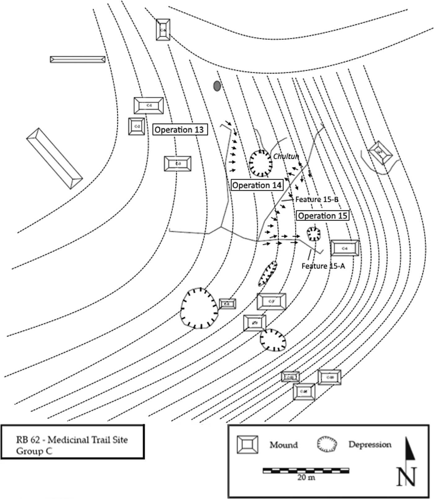
Three studies associated with Group C have been conducted in attempts to identify additional structures and features and their potential role in water management activities in this area of the Medicinal Trail site (Dedrick Reference Dedrick, Trachman and Valdez2009; Gill Reference Gill, Trachman and Valdez2009; Percy Reference Percy, Trachman and Valdez2009). Group C is classified as a small Second Tier courtyard group and is located 50 m south of the Tapir Group. Households in Second Tier groups are characterized by two or three structures arranged around a semi-formal courtyard and lack eastern ceremonial structures (Brewer et al. Reference Brewer, Hyde, Stowe and Valdez2013). Group C consists of three courtyard groups dispersed around a series of landscape modifications, including terraces, berms, and depressions, likely related to agricultural activities (Figure 6). The topography surrounding the group is steep relative to the extensive, low-lying plain to the east, and a series of interconnected berms appear to function to direct water away from the larger Tapir Group household toward four reservoirs. The flat plain below Groups C and D contains multiple terraces and reservoirs that, if coordinated, would have collected rainwater from upslope and distributed into adjacent agricultural fields.
Plan map of Group C at Medicinal Trail detailing Operations 14 and 15. Dashed lines show general contours and arrows indicate probable flow of water along berms toward the Operation 14 chultun and Operation 15 depression. Adapted from Hyde (Reference Hyde2011).

Operation 15 focused on determining the function of three landscape features posited to relate to water management activities: two berms and an associated depression (Gill Reference Gill, Trachman and Valdez2009). The relationship between water management features used to capture and redirect water for consumption and agriculture has been well documented throughout the Maya area and berms, in particular, have been found at a variety of nearby sites within the Rio Bravo Conservation Area including La Milpa and Guijarral (Dunning and Beach Reference Dunning and Beach2003; Hughbanks Reference Hughbanks, Adams and Valdez1995; Scarborough Reference Scarborough2003). The slope, alignment, and composition—limestone and chert construction cobbles ranging in size from 5–45 centimeters in diameter—of Feature 15-A present both internal and external features of a berm. The pitched, “roof-like” construction may have been used to divert water along its east and west margins (Gill Reference Gill, Trachman and Valdez2009). Similarly, Feature 15-B appears to have been used to slow and direct the flow of water downslope toward the southeastern depression. Ground survey of this depression revealed several cut marks in the limestone along its southern boundary and a large, poorly preserved limestone boulder was removed from its western half (Operation 15 F). Taken together, these findings suggest that the depression was quarried for construction material before serving in some capacity as a reservoir. Analysis of the ceramic material recovered in the Operation 15 excavations reveal a Late Classic construction and use of these features, which correlates with occupation dates documented for this area of the site (Dedrick Reference Dedrick, Trachman and Valdez2009; Gill Reference Gill, Trachman and Valdez2009).
At the north end of Group C is a semi-formal courtyard group of three mounds with a possible chultun and two depressions separated by a long berm to the east and southeast (Dedrick Reference Dedrick, Trachman and Valdez2009). At its southern end, this nearly 40-meter-long berm hooks to the east and appears to intersect with a small separate berm investigated as part of the Operation 15 excavations. The depression studied at Operation 15 is located southeast of this intersection and a ditch that appears to be a drainage feature begins at this feature and winds its way south to an additional depression (Brewer et al. Reference Brewer, Hyde, Stowe and Valdez2013). The primary objective of Operation 13 was to examine three structures that share a common basal platform, their immediate surroundings, and the role this segment of the community may have played in the economic activities of Medicinal Trail. In northwestern Belize, multiple hilltop-focused agricultural sites are composed of large, economically prosperous household groups surrounded by smaller household groups associated with visible agricultural features (Lohse Reference Lohse, Lohse and Valdez2004). The nature of these smaller households in the agricultural production of hilltop sites lacks in-depth study, and the similar configuration of Medicinal Trail offers an analogous dataset to consider. The water management component of the Operation 13 investigations was the series of excavations conducted at an apparent chultun within the center of Group C (Operation 14). Limited in scope, the primary purpose of this operation was to establish a basic soil stratigraphy and examine the bedrock morphology within the feature. Although no obvious modifications to the bedrock were observed, cultural material in the form of lithic flakes and ceramic sherds were collected. No dates were assigned to the ceramic material, and it is hypothesized that this depression functioned in tandem with the adjacent berms in order to collect, and possibly redistribute, water for agricultural purposes (Percy Reference Percy, Trachman and Valdez2009). As with other potential water management features surveyed and cursorily tested throughout the site, the hydrologic infrastructure associated with Group C requires additional excavation and analysis.
HOUSEHOLD WATER MANAGEMENT AT YAXNOHCAH
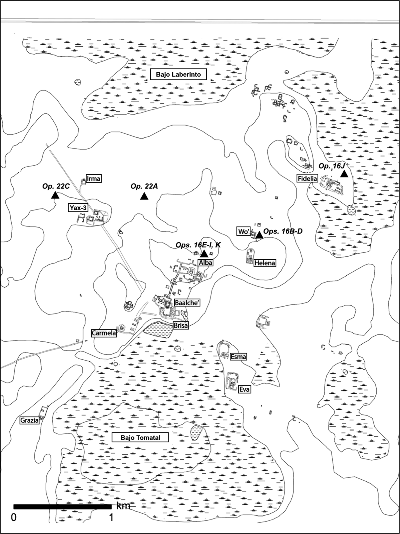
Yaxnohcah (UTM coordinates: 16Q 287077 1880641) lies between the major sites of Calakmul and El Mirador within the Central Karst Uplands of the Yucatan Peninsula. The site was initially reported by Ruppert and Dennison (Reference Ruppert and Dennison1943:45) following a brief visit in 1933 and given the name Monterey after a nearby aguada. The site was revisited in 2004 by Šprajc and colleagues, who investigated the area in more detail, mapped six groups of monumental architecture, and renamed the site Yaxnocah—meaning “first big city” (Šprajc Reference Šprajc2008). In addition to the large civic-ceremonial architectural complexes (designated Groups A–F) and two expansive elite residential complexes included in this survey, the site is also defined by two expansive bajos: Bajo Tomatal to the south and Bajo Laberinto to the north and northeast (Figure 7). Today, most bajos are characterized by severe moisture fluctuation ranging from inundation in the wet season to complete desiccation in the dry. The role that bajos played in the rise and fall of Maya civilization in this region has been a matter of vigorous debate and, despite considerable recent research, still eludes consensus. Scholarly views of ancient land use in bajos have ranged from very limited agriculture to widespread intensive wetland field systems. The reality likely lies somewhere in between these opposing views and further investigation is certainly required (cf. Adams Reference Adams1991; Culbert et al. Reference Culbert, Levi, Cruz, Clancy and Harrison1990; Dunning et al. Reference Dunning, Beach, Luzzadder-Beach, Lucero and Fash2006; Hansen et al. Reference Hansen, Bozarth, Jacob, Wahl and Schreiner2002; Pope and Dahlin Reference Pope and Dahlin1989; Wahl et al. Reference Wahl, Byrne, Schreiner and Hansen2006). The presence of aguadas within and along the margins of bajos suggests that these reservoirs may have facilitated agriculture. At Yaxnohcah, two flanking “bajo-margin” aguadas located next to major architectural groups, the Brisa and Fidelia reservoirs, have undergone archaeological testing to gather data on their chronology and construction, with additional large aguadas surveyed and scheduled for similar study in upcoming seasons (Dunning et al. Reference Dunning, Hernández, Geovannini, Hernández, Peuramaki-Brown and Reese-Taylor2018).
Overview of Yaxnohcah, showing the location of the five operations discussed in the text. Map adapted from Reese-Taylor et al. (Reference Reese-Taylor, Armando, F. C., Kelly, Juan, Alejandro, Christopher, Helga, Meaghan and Nicholas2016).

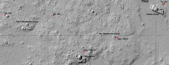
At the household level, small reservoirs located adjacent to many of the residential groups identified at Yaxnohcah would have provided an additional accessible water supply for the community. During the past two field seasons of the Yaxnohcah Archaeological Project (YAP), five of these residential tanks have been excavated to determine the chronology of their construction and the nature of their role in water management at the household level (Brewer Reference Brewer, Hernández, Peuramaki-Brown and Reese-Taylor2018; Brewer and Carr Reference Brewer, Carr, Hernández, Peuramaki-Brown and Reese-Taylor2018; Brewer et al. Reference Brewer, Carr, Dunning, Walker, Hernández, Peuramaki-Brown and Reese-Taylor2017). Prospective reservoirs were initially identified in the analysis of Light Detection and Ranging (LiDAR) imagery obtained by YAP (Figure 8; Brewer et al. Reference Brewer, Carr, Dunning, Walker, Hernández, Peuramaki-Brown and Reese-Taylor2017; Reese-Taylor et al. Reference Reese-Taylor, Armando, F. C., Kelly, Juan, Alejandro, Christopher, Helga, Meaghan and Nicholas2016, Reference Reese-Taylor, Armando, F. C., Kelly, Alejandro J., Helga and Chris2018) and then verified through ground survey. The goal was to examine and evaluate these small depressions as potential water features in areas where the project had gathered, or was in the process of accumulating, chronological and cultural data from residential structures (Peuramaki-Brown et al. Reference Peuramaki-Brown, Morton, Castro, Hernández, Peuramaki-Brown and Reese-Taylor2018).
Light Detection and Ranging (LiDAR) image section of Yaxnohcah showing the location of the five depression reservoirs investigated by the author. Map adapted from Brewer et al. (Reference Brewer, Carr, Dunning, Walker, Hernández, Peuramaki-Brown and Reese-Taylor2017).

Wo’ Group Residential Reservoir (Operations 16B, 16C, and 16D)
The first reservoir tested was located 45 m southeast of the Wo’ Group residential complex then being investigated (Peuramaki-Brown et al. Reference Peuramaki-Brown, Morton, Castro, Hernández, Peuramaki-Brown and Reese-Taylor2018). Three excavations (16B, 16C, and 16D) were opened in this irregularly shaped, shallow depression resulting in a contiguous 1.5 × 1.5 m unit positioned on the eastern margin lip of the feature. The goal of these excavations was to investigate the possible presence of a water retention wall, channel, or other modification, targeting places with exposed limestone visible on the surface of the rim and with suggestive surrounding topography.
Based upon the exposed limestone at the base of the unit, which displays evidence of cut marks on several blocks, this depression appears to have initially functioned as a quarry for building material (Figure 9). If limestone blocks were being mined for construction in the immediate vicinity, their most likely destination would be the adjacent Wo’ Group. Indeed, initial comparative analyses of ceramic material from the depression and Operation 17 F at the structure group itself indicate contemporaneity in Early/Middle Preclassic forms (Walker Reference Walker, Hernández, Peuramaki-Brown and Reese-Taylor2018). This apparent temporal (and type) relationship between operations, combined with the accessibility of the depression's location, support the notion that the feature could well have functioned as a quarry for Preclassic period building material at the Wo’ Group. The lack of either a channel or other culturally modified feature in this area of the depression or evidence of a clay sealant call into question the notion that this feature served as a residential water tank. Its surface area, depth, and location bordering a residential complex in an area lacking any other visible water features, however, support the idea that this depression may have been utilized as an opportunistic water source, or “quarry reservoir,” perhaps for non-potable purposes. In addition, the catchment area bordering the south, west, and southeast sides of the depression would have been positioned to either receive outflow from or shed runoff into the reservoir, probably for agricultural purposes. Similar depressions originating as quarries before being modified and used as reservoirs have been identified elsewhere across the Maya lowlands (Folan Reference Folan1982; Weiss-Krejci and Sabbas Reference Weiss-Krejci and Sabbas2002).
South profile of Operations 16B, 16C, and 16D, showing location of cut stones. Drawing by author.

Suburban Alba North Residential Reservoir (Operations 16E–16I and 16 K)
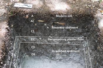
The second small depression was located 130 m northeast of Structure A-1 of the Alba Group, near a series of nearby house mounds that had not yet been excavated. Three separate operations were initiated across the center and along the north rim of the feature. Sascab exposed at the base of the depression was flat, smooth, and was overlaid by a thick layer of sediment (Figure 10). The depression likely originated as a quarry associated with the construction of the nearby massive Alba Group monumental architecture, before becoming partly filled with in-washing sediment (C3 and C4 horizons), sealed with a now highly degraded plaster floor (C2 horizon), and further filled by accumulating reservoir sediments (C1 and AC horizons). Although not representative of the type of well constructed and maintained watertight seals overlying the bedrock in the larger central precinct reservoirs found within many Maya urban centers, this plaster surface would, nonetheless, have served to greatly increase water retention within the reservoir. The profiles of Operations 16E and 16 F revealed a similar deposition of reservoir sediments, but evidence of this former floor was visible only in 16 F, located in the center of the depression.
Operation 16 F west profile, showing remnants of a highly weathered plaster floor. Photograph by author.

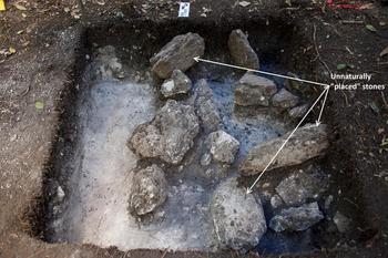
Contiguous operations 16G, 16H, 16I, and 16 K, located on the north rim of the depression, presented another interesting aspect of the tank. Large rocks exposed throughout this unit appear to be the result of deliberate cultural activity, based on their placement above the C soil horizon and their alignment (Figure 11). In addition, the collapse of these stones also appears to have dislodged other unnaturally placed stones. The type and nature of the feature that these stones would have comprised remains unknown, although it is evident that some type of construction activity was taking place around the perimeter of the reservoir.
Base of Operations 16G, 16H, 16I, and 16 K, showing large placed stones. Photograph by author.

Excavation findings combined with a high density of ceramic material (n = 610) and a proximate spatial association with the Alba Complex support the idea that this depression functioned as a reservoir. The reservoir's surface area and calculated volume combined with the topography of the surrounding landscape, which could have shed water downslope into the reservoir from a large catchment surrounding it on the west, south, and east sides, further support the feature's water storage capabilities. Although the neighboring residential groups have yet to be excavated, it is likely that ceramics recovered in the depression will coincide with dates associated with these structures, supporting the idea that the reservoir was in use concurrent with occupation in this area of the site.
Suburban Fidelia North Residential Reservoir (Operation 16J)
The only depression not located on the Alba-Fidelia transect, this small tank was located 130 m north of Structure F-1 of the Fidelia Complex. An L-shaped mound group is located immediately adjacent to the northern edge of the reservoir and the working hypothesis, based on its layout and recovered ceramic dates from nearby test excavations, was that this location was the likely setting for an Early Classic period farmstead. Another apparent reservoir that contains a possible sluice gate or dam feature is located 80 m to the south. Earlier investigations in this area included a 2 × 2 m excavation unit placed between these two depressions, from which DNA samples were recovered from soil containing both cotton and maize indicators (Anaya Hernández Reference Anaya Hernández, Reese-Taylor and Hernández2013). A water retention feature in the south depression could have served to allow and regulate the release of water into this field separating the two tanks, with the agricultural water runoff then funneling into the Suburban Fidelia North reservoir. This collected runoff could have then been recycled for non-potable uses, such as additional pot irrigation.
The current shallow profile of the small reservoir is the result of over one thousand years of sedimentation and soil formation following its use and abandonment. A series of exposed stones that appear to be aligned, possibly indicating the remains of a cultural feature, are located along the western margin of the depression, which also forms its highest present edge. Within the depression, evidence of a decomposing floor and superjacent reservoir sediments like those examined in the Suburban Alba North reservoir are visible in the profile (Figure 12). Nearly 150 centimeters below the surface, the C3 horizon consists of weathered remains of a floor constructed of hard-tamped clay mixed with sandy sascab, a technique still used today to line irrigation ditches and other hydrologic features in the Yucatán (Dunning et al. Reference Dunning, Weaver, Smyth, Zapata and Stanton2014). Above this surface, a thick layer of clayey reservoir sediments (C2 horizon) accumulated over time, with broken ceramics and other artifacts intermixed. Episodic seasonal desiccation of these sediments appears evident in the development of slickensides, a product of shrinking and swelling clay, which also caused distortion in the underlying floor. During the final years of its use, or post-abandonment, the depression then began to fill with colluvial sediment (C horizon) derived from the disintegration of the adjacent residential complex, out of which the modern soil developed over a millennium. Two small charcoal fragments were recovered from the southwest corner of the unit at a depth approximately 1.55 meters below the surface and submitted for 14C dating. This analysis returned a date of 1570 ± 30 with the calibrated age 415–560 cal a.d. (p = 0.95; calibrated at 2-sigma with the program INTCAL13 [Reimer et al. Reference Reimer, Bard, Bayliss, Beck, Blackwell, Ramsey, Buck, Cheng, Edwards, Friedrich, Grootes, Guilderson, Haflidason, Hajdas, Hatté, Heaton, Hoffmann, Hogg, Hughen, Kaiser, Kromer, Manning, Niu, Reimer, Richards, Scott, Southon, Staff, Turney and van der Plicht2013]), correlating strongly with the presence of Middle Classic ceramic material also present at this depth (Walker Reference Walker, Hernández, Peuramaki-Brown and Reese-Taylor2018). Similar to the Suburban Alba North reservoir, dates attached to recovered ceramics coincided with dates associated with the neighboring residential complex, indicating that this reservoir was in use during the occupation of this area of the site.
Operation 16J north profile, showing location of colluvium deposits. Drawing by author.

This relatively small, but originally deep, depression appears to have functioned in a water management capacity based on multiple spatial, physical, and cultural characteristics. The position of the depression immediately adjacent to an agricultural field (with another probable reservoir located on the west side of the field) and a structure group; its depth combined with the presence of a weathered plaster floor and evidence of intermittent desiccation/rehydration cycles in the stratigraphy; and high densities of ceramic material (n = 208) throughout the unit suggestive of cultural activity all support the notion that this depression served as a household reservoir, possibly to collect water from, or distribute water to, the bordering agricultural field.
Yax-3 Hinterland Aguada (Operation 22A)
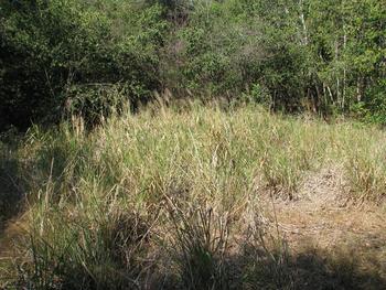
The fourth depression excavated at Yaxnohcah is located roughly 500 meters northeast of the Yax-3 group's center. The size (30 m north-south × 30 m east-west) and roughly circular shape of this feature resembles a natural karst sinkhole with a clay plug in its bottom (Nicholas Dunning, personal communication 2016). Unlike the other small tanks tested, this depression contained vegetation indicative of the presence of water for at least part of the year (Figure 13). Fairly dense stands of saw grass and sedges, including Cyperus and Rhynchospora species and the cattail Typha dominguensis, were documented. These species have been associated with seasonally inundated aguadas elsewhere in the Maya area, including the sites of Tikal (Dunning et al. Reference Dunning, Griffin, Jones, Terry, Larsen, Carr, Lentz, Dunning and Scarborough2015) and Pulltrouser Swamp (Darch Reference Darch, Turner and Harrison1983). The fact that the depression was currently completely dry is not surprising considering investigations took place in mid-May, near the end of the annual dry season. Its profile as an active aguada was further supported by the presence of modern artifacts noted around the perimeter, including a chiclero (gum tapper) boiling pot, multiple glass bottles, and a shoe, suggesting recent historical use of the feature. Two small metal fragments were collected 70 cm below the ground surface, also evident of recent activity. The nearest ancient structure to the aguada, located 30 m west, has not been investigated but falls well within an accessible radius to take advantage of this reservoir. Additional residential groups are located 100 m northeast and 125 m southwest.
Pre-excavation image of the Yax-3 Hinterland Aguada. Photograph by the author.

The depression is oval-shaped and currently fairly shallow, due to continual sedimentation and soil formation. A rise or “rim” is evident along the south edge, increasing significantly from west to east around the aguada's perimeter. This rim is also visible, but less defined, on the north side of the feature. A single 1 × 1 m unit was placed in the center and excavations reached a total depth of nearly two meters below present ground surface. Although no surface water was present, massive surface cracks visible in the stratigraphic profile are indicative of recent soil dehydration. These cracks continue over 50 centimeters into the profile through an increasingly sticky and moist clay matrix. The modern soil is a vertisol exhibiting significant shrink-swell behavior and subsequent clay movement (argilliturbation) over time. Aguadas have proven to be important sources of paleoecological data, the sediments within them often deposited in standing water with anaerobic conditions leading to the preservation of pollen and other microfossils (Akpinar-Ferrand et al. Reference Akpinar-Ferrand, Dunning, Lentz and Jones2012; Beach et al. Reference Beach, Luzzadder-Beach, Flood, Houston, Garrison, Román, Bozarth, Doyle, Lentz, Dunning and Scarborough2015b). In an effort to identify ancient vegetation present in the localized area surrounding the aguada, 15 pollen samples were collected from the south wall of the unit at 10-cm intervals between depths of 20 and 150 cm below ground surface. Analysis of these samples is ongoing.
A total of 94 ceramic sherds were recovered, tentatively dated to the Classic period (Debra Walker, personal communication 2016). Although the density of ceramic material was relatively consistent throughout the majority of the excavation unit, no artifacts were encountered in the dense, sticky clay (approximately 20 centimeters deep) overlying the sascab base of the aguada. Combined with a lack of cultural material at this depth, the composition of this thick bajo clay suggests that it acts as a natural aid in water retention. A pronounced topographical depression represents a natural place to collect water and, as has been reported elsewhere in the Maya lowlands, aguadas may begin to collect water due to the natural consequences of sedimentation by clays (Beach et al. Reference Beach, Luzzadder-Beach, Flood, Houston, Garrison, Román, Bozarth, Doyle, Lentz, Dunning and Scarborough2015b; Dunning et al. Reference Dunning, Luzzadder-Beach, Beach, Jones, Scarborough and Culbert2002). Whether deliberately deposited or not, the clay lining within the Yax-3 hinterland aguada would have increased the reservoir's ability to store water and supplement ground and surface water, or provide water in dry periods. Although lacking evidence of a former floor or sealed surface, the present vegetation and significant surface cracks are indicative of a current water feature. Based on associated ceramic dates, this feature appears to have originated naturally and, after partially filling with in-washing clay reservoir sediments, served as a reservoir beginning in the Classic period. It is possible that the reservoir was in use earlier, with antecedent sediment and associated ceramics having been removed by later (Classic period) dredging. Many aguadas have stratigraphic disjunctions as a result of periodic ancient dredging (e.g., Dunning et al. Reference Dunning, Griffin, Jones, Terry, Larsen, Carr, Lentz, Dunning and Scarborough2015).
Yax-3 Group Reservoir (Operation 22C)
The final small water feature investigated to-date at Yaxnohcah is located within the Yax-3 residential group currently being investigated by YAP (Anaya Hernández et al. Reference Anaya Hernández, Peuramaki-Brown, Reese-Taylor, Hernández, Peuramaki-Brown and Reese-Taylor2018). Massive exposed limestone blocks visible around the feature's rim, particularly along its south and west boundaries, and the presence of multiple structures within 75 meters of the reservoir (including a large structure bordering its eastern edge) indicate that this depression likely originated as a quarry associated with the construction of this residential complex before being modified and used as a small reservoir. Unfortunately, excavation could not be carried to bedrock in this depression because of time constraints and safety concerns.
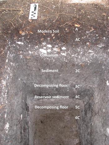
Excavation of the depression produced a wealth of cultural and physical data, including a significant density of ceramic material. This consisted of multiple shallow vessel rim sherds, including one large Polvero Black bowl rim fragment with slip still largely intact. The ceramic mix from this operation tentatively dates from the Late Preclassic to Late Classic periods (Debra Walker, personal communication 2016). A charcoal sample recovered from the south wall (125 cm below ground surface) returned the date 2270 ± 20 with the calibrated age 400–210 cal b.c. (p = 0.95; calibrated at 2-sigma with the program INTCAL13 [Reimer et al. Reference Reimer, Bard, Bayliss, Beck, Blackwell, Ramsey, Buck, Cheng, Edwards, Friedrich, Grootes, Guilderson, Haflidason, Hajdas, Hatté, Heaton, Hoffmann, Hogg, Hughen, Kaiser, Kromer, Manning, Niu, Reimer, Richards, Scott, Southon, Staff, Turney and van der Plicht2013]), lending further support for use of the reservoir during the Late Preclassic. The weathered remains of two distinct surfaces visible in the profile represent multiple periods of use and refurbishment of the reservoir that appears to coincide with this range of ceramic dates (Figure 14). Atop a layer of in-washed sediment, the 5C horizon consists of a now highly weathered plaster floor beneath a thick, dark layer of reservoir sediments accumulated along with cultural material (4C horizon). These sediments also contained manganese and iron oxide concretions, indicative of the presence of abundant soil water at this depth of the depression. Above this is a degraded floor composed of a mixture of very dark, hard-tamped clay and sandy sascab similar to the former surface uncovered in Operation 16J. Another layer of reservoir sediments (2C horizon) and colluvium sediment resulting from the disintegration of the adjacent residential complex are located beneath the well-developed modern soil.
North profile of the Yax-3 Group Reservoir, showing evidence of multiple highly weathered floors.

Taken together, the physical and cultural data recovered from this operation indicate that the depression likely originated as a limestone quarry during the Late Preclassic, or perhaps earlier. After subsequently filling with a layer of in-washing sediment, the tank was sealed with a plaster floor for use as a reservoir during this period. Following the accumulation of additional reservoir sediments, perhaps indicating a period of disuse or abandonment in this area of the site, the tank was again sealed with a clay-and-sascab surface to improve its water retention. The presence of a similarly constructed floor in the Operation 16J tank north of Fidelia—also dating to the Classic period—suggests this technique was employed as a low-cost (relative to plaster) solution for seasonal water storage throughout Yaxnohcah during this time.
DISCUSSION
Considering the importance of water management in Maya culture, the potential role that small depressions of varying sizes and shapes played in supplying water is a critical element in the interpretation of ancient Maya physical and cultural landscapes. Investigations of residential-scale water management infrastructure at Medicinal Trail and Yaxnohcah have revealed that small reservoirs and associated landscape modifications served various purposes within their communities. These findings suggest that many small depressions likely originated as quarries before being modified for water storage and agricultural uses. Small household reservoirs, modified with a clay or plaster lining and combined with the use of terraces, berms, and silting tanks, represented a sustainable engineering solution for the ancient Maya to help store water in a seasonally water-deficient environment. In addition, despite the invaluable advantages offered by LiDAR in identifying small depressions beneath the dense forest canopy of the lowlands (Brewer et al. Reference Brewer, Carr, Dunning, Walker, Hernández, Peuramaki-Brown and Reese-Taylor2017; Chase Reference Chase2016; Chase and Weishampel Reference Chase and Weishampel2016; Chase et al. Reference Chase, Chase, Weishampel, Drake, Shrestha, Slatton, Awe and Carter2011), this study also emphasizes the continued necessity of assessing water features based on a combination of observations derived from ground verification and excavation.
In a region largely devoid of significant permanent water sources, small reservoirs were vital components in the daily lives of their community's residents and undoubtedly served a variety of potable and non-potable needs. For researchers seeking to understand the lifeways and cultural activities of an area's inhabitants, these features have proven to be important sources of cultural and environmental data. The study of aguadas provides archaeologists with the added benefit of the paleoenvironmental data they preserve, including ancient pollen, charcoal, and sedimentary evidence of past climatic drying. Pollen sequences gathered from aguadas reflect local vegetation, as these small bodies of water can capture the localized pollen of less-common plant species whose pollen does not travel far (Akpinar-Ferrand et al. Reference Akpinar-Ferrand, Dunning, Lentz and Jones2012). As a result, the pollen extracted from aguadas, particularly when combined with supporting material data, could also prove valuable in revealing the function of these hydrologic features within ancient Maya agriculture. Although the majority of completely dry residential tanks unfortunately lack useful pollen indicators, the evidence they provide in terms of anthropogenic modifications to enhance their water holding capabilities, their physical profile (surface area, depth, and volume), and their spatial and temporal integration into communities supports the theory that they were employed similarly to aguadas to fulfill the water needs of the ancient Maya.
A series of water management studies conducted at Medicinal Trail revealed a multi-component system of water features incorporated into a dispersed hinterland community engaged in agricultural production. Located within a few kilometers of the major site of La Milpa, this community consists of multiple formal courtyard groups, numerous informal mound clusters, and multiple landscape modifications including depressions, terraces, and berms (Hyde Reference Hyde2011). In their discussion of “dualistic economies,” emerging nation states, and the ancient economy of the lowland Maya, Scarborough and Valdez (Reference Scarborough and Valdez2009) propose the formation of resource-specialized communities, of which Medicinal Trail might be classified. These settlements were linked in a largely interdependent matrix that permitted a certain amount of self-sustaining separation from the large monumental centers with which they were spatially associated and about which we have the greatest knowledge. Similar to minor sites found elsewhere in the Three Rivers Region, such as Chawak But'o'ob (Walling et al. Reference Walling, Davis, Dias, DeVito and Valdez2005, Reference Walling, Davis, Hanna, Matthews, Prasarn and Taylor2006) and Grupo Agua Lluvia (Trachman Reference Trachman2007), Medicinal Trail is characterized as a small community of relatively diminutive civic architecture, organized around a defined center, and engaged in low-cost water management engineering. Located on an escarpment edge, the site contains the centrally located Medicinal Trail Reservoir and a series of landscape modifications geared toward domestic water collection and storage. The capacity of the Medicinal Trail Reservoir alone, 88 m3, would have supplied the households around Group A with a significant amount of water throughout much of the year. Combined with the additional supply provided by the other, smaller reservoirs, Medicinal Trail and its water supply would likely have functioned as a centralizing node for resource access among intercommunity members during the dry season and perhaps beyond.
Despite its importance as a specialized resource community, however, and similar to other resource specialized communities in the region, Medicinal Trail never expanded beyond a hinterland companion to neighboring La Milpa. The political, economic, and social gravity of this major center would have attracted tribute, trade, and ceremonial interactions with the residents of Medicinal Trail, some of which would likely have involved water requirements. As Lucero (Reference Lucero2006) details, traditional rituals performed on a grand scale, including prayers for abundant water and various dedication, ancestor veneration, termination, and other household and community rites, were a primary means that ruling elites used to bring together Maya farmers and other commoners during the Classic period. This elite-commoner relationship, centered in part on the importance of water collection and management, would have served as an important link between the agricultural community of Medicinal Trail and the urban center of La Milpa. Nonetheless, this investment in water management at the household scale permitted the social and economic interrelationships necessary for the community to organize and operate alongside other specialized communities largely independent from a large urban center.
In contrast, Yaxnohcah emerged within a network of Preclassic cities, including Calakmul, Nakbe, and El Mirador, as a massive archaic city-state in the Central Karstic Uplands. The site grew into a large urban center early in the Preclassic period, survived the Preclassic “collapse” that engulfed some of its neighbors, and became a Classic period center of some significance before abandonment in the Terminal Classic (Anaya Hernández et al. Reference Anaya Hernández, Peuramaki-Brown, Reese-Taylor, Hernández, Peuramaki-Brown and Reese-Taylor2018). The evolution and sustainability of Yaxnohcah was based on significant hydraulic, agricultural, settlement, and landscape modification strategies that allowed the persistent occupation of the site in the midst of changing environmental and political economic conditions. The massive Reservario Brisa and Aguada Fidelia, likely constructed during the Middle and Late Preclassic periods, respectively, illustrate the sophistication of an urbanized reservoir-based water system that operated into the Classic period (Dunning et al. Reference Dunning, Hernández, Geovannini, Hernández, Peuramaki-Brown and Reese-Taylor2018). The system was established and modified over time to compensate for changes in population density and distribution around the urban core, fluctuations in water availability, and developments in political structure and control. This deliberate “built environment” adopted a comprehensive land-use strategy of sizable reservoirs designed to receive large quantities of surface water runoff flowing seasonally from the Fidelia and Brisa Group plazas, pyramids, and palaces that typified Yaxnohcah during the Classic period. At the household, or decentralized, scale, hydrologic modifications in the form of creating and maintaining small water tanks took place in tandem with these community-wide, centralized investments in water management. The creation and use of smaller aguadas and household tanks by a growing hinterland population fanning out from the urban core, combined with the continued intensive exploitation of bajo areas as cultivated and managed wetland forests and agricultural zones, characterized residential scale water management activities at Yaxnohcah from the Middle Preclassic into the Classic period. Chultuns, identified through ground survey at multiple locations within the site, may also have served to store water for the residents of Yaxnohcah. Their role in water management has been documented throughout the Maya area, particularly in the Puuc Hills and northern Yucatán Peninsula (Gill Reference Gill2000; Isendahl Reference Isendahl2011; Matheny Reference Matheny and Flannery1982; McAnany Reference McAnany, Culbert and Rice1990; Puleston Reference Puleston1971; Scarborough Reference Scarborough and Schiffer1991, Reference Scarborough2003; Scarborough and Gallopin Reference Scarborough and Gallopin1991).
Importantly, this study also contributes to the recent, and ongoing, discussion on the social, political, and economic roles that smaller, decentralized water management features likely played within their communities (Weiss-Krejci and Sabbas Reference Weiss-Krejci and Sabbas2002; Wyatt Reference Wyatt2014). Examination of the ancient reservoir technology employed throughout the tropical wet-dry forests of the southern lowlands reveals the significance of collection and storage and strongly suggests a program of centralized water management (Dunning et al. Reference Dunning, Griffin, Jones, Terry, Larsen, Carr, Lentz, Dunning and Scarborough2015; Scarborough and Gallopin Reference Scarborough and Gallopin1991; Scarborough and Grazioso 2015). This relationship between the control and management of water and the consolidation of power in the Maya area has been examined by multiple scholars and the essential need for water would have made the management of this resource in a delicate, water-stressed environment a powerful organizing force (cf. Ford Reference Ford and Fedick1996; Lucero Reference Lucero, Bacus and Lucero1999, Reference Lucero2002, Reference Lucero2006; Scarborough Reference Scarborough and Schiffer1991, Reference Scarborough, Scarborough and Isaac1993, Reference Scarborough and Fedick1996, Reference Scarborough1998; Scarborough and Valdez Reference Scarborough, Valdez, Scarborough, Valdez and Dunning2003, Reference Scarborough and Valdez2009). As investigations of residential-scale water management continue, however, the relationship between water control, settlement, and power appears increasingly nuanced. Data from both Medicinal Trail and Yaxnohcah support the idea that water management activities at the household level were established by the Middle Preclassic and would have represented a dependable and substantial source of water for individuals and corporate groups through the Late Classic period. The presence and use of these smaller, spatially dispersed features spatially and temporally in tandem with large, centralized reservoirs has been noted elsewhere in the Maya lowlands, where scholars continue to investigate their origins and functions (Chase Reference Chase2016; Weiss-Krejci and Sabbas Reference Weiss-Krejci and Sabbas2002). In addition to strengthening the argument that ancient lowland Maya communities could have relied on decentralized water sources, the methods and analyses employed in this study reinforce earlier investigations demonstrating the importance of employing archaeological excavations to the evaluation of topographical depressions as potential water features (Brewer Reference Brewer2007; Brewer et al. Reference Brewer, Carr, Dunning, Walker, Hernández, Peuramaki-Brown and Reese-Taylor2017; Weiss-Krejci Reference Weiss-Krejci2013; Weiss-Krejci and Sabbas Reference Weiss-Krejci and Sabbas2002).
CONCLUSION
Small depressions are a recurrent landscape feature throughout the central Maya lowlands and systematic studies conducted over the past few decades have demonstrated that they served a variety of cultural functions, including water reservoirs. The majority of these small tanks are thought to have originated naturally within the topography as karst sinkholes that were then modified by the Maya to enhance water storage. A combination of approaches from surface observation, excavation, and artifact and soil analysis is required to determine their origin and function. Excavation data from a series of residential-scale water features at the sites of Medicinal Trail and Yaxnohcah in the central Maya lowlands demonstrate that at least some of these features originated as limestone quarries prior to serving as household or small communal reservoirs.
Occupying an area largely devoid of lakes and rivers, the lowland Maya of the Preclassic and Classic periods met the challenges of the annual extended dry season by constructing water catchment systems to provide water that would last until the rains began again. In hinterland communities such as Medicinal Trail, these small-scale systems were built and maintained at the household level among families living in farmsteads dispersed throughout the jungle. Data from Yaxnohcah show that, within large urban centers, similar hydrologic infrastructure developed at the household level, indicating at least some degree of autonomy in individuals and families meeting their daily water needs throughout the year.
Reservoirs, check dams, canals, terraces, and other water or agricultural subsistence technologies reflect local adaptive strategies as well as the number of people they can service. Small-scale systems are built and maintained at the household or community level and their location and scale typically reflect their role in social, economic, and political life. Additional studies of small water reservoirs in the Maya lowlands are necessary to further clarify the nature and extent of these water management adaptations. These findings will help illuminate possibly changing patterns of water management at the household scale, such as a reliance on decentralized instead of centralized sources, and how these relationships varied across space and time both adjacent to the urban core and within the more distant hinterlands.
RESUMEN
Múltiples estudios realizados en las últimas décadas han reconocido la necesidad de la recolección y el almacenamiento de agua de lluvia como un aspecto crítico en la evolución de la civilización maya. Sin embargo, pocos de estos esfuerzos han enfatizado la importancia de administrar los recursos hídricos a nivel de los hogares. Los datos se presentan desde dos sitios centrales de tierras bajas—la comunidad dispersa del interior del Medicinal Trail y el centro urbano de Yaxnohcah—que dilucidan la función de los pequeños embalses y las modificaciones paisajísticas asociadas en el manejo del agua residencial. A pesar de las diferentes geografías físicas y las trayectorias del desarrollo urbano, los residentes de ambas comunidades se dedicaron claramente a actividades de gestión del agua basadas, al menos en parte, en la creación y el uso de pequeños embalses. Las prácticas descentralizadas de gestión del agua doméstica parecen haber sido componentes generalizados, tanto temporales como espaciales, de la civilización maya que comenzó en el período preclásico.
ACKNOWLEDGMENTS
I would like to thank the anonymous reviewers, Dr. Nick Dunning, and Dr. Chris Carr for their valuable inputs and suggestions. Special thanks go to the local field workers who assisted with the archaeological excavations detailed here, particularly Javier Cobos, Augustín Diaz, and Reyes Pérez Martínez of YAP. The work reported in this article was funded by a National Science Foundation grant (PI: Nicholas P. Dunning; Co-PI: Jeffrey L Brewer; NSF Award Number 1519015) and the Taft Research Center at the University of Cincinnati. The work was accomplished as part of the Programme for Belize Archaeological Project directed by Dr. Fred Valdez and the Proyecto Arqueológico de Yaxnohcah directed by Kathryn Reese-Taylor and Armando Anaya Hernández.