




Introduction
Studies on resource-rich countries have long suggested that substantial inflows of extractive industry revenues cause many adverse macro-economic, political and social effects, commonly labelled as the ‘resource curse’ (for reviews, see Ross Reference Ross2014; Gilberthorpe & Papyrakis Reference Gilberthorpe and Papyrakis2015; Alssadek & Benhin Reference Alssadek and Benhin2023). More recent studies have provided evidence that the anticipation of future natural resource revenues (as opposed to actual inflows of resource revenues) can also lead to similar negative macro-economic and political effects even before resource extraction takes place – a phenomenon labelled ‘the presource curse’ (Cust & Mihalyi Reference Cust and Mihalyi2017; Arezki et al. Reference Arezki, Ramey and Sheng2017; Frynas et al. Reference Frynas, Wood and Hinks2017). This article specifically investigates the impact of the presource curse in relation to boundary disputes between African states.
The resource curse literature has long demonstrated that the inflow of natural resource revenues escalates societal conflicts. The inflow of extractive revenues reduces incentives for human cooperation, as the prospects of gaining control over resource revenues fuel the activities of rebel groups, potential coup leaders and other violent forms of political opposition (Collier & Hoeffler Reference Collier and Hoeffler1998; Humphreys Reference Humphreys2005; Gutiérrez Rodríguez Reference Gutiérrez Rodríguez2019), while ruling elites often use windfall revenues to significantly increase arms imports and to eliminate the political opposition by force (Macuane et al. Reference Macuane, Buur and Monjane2018; Vézina Reference Vézina2020). Studies on the presource curse suggested that the hype around future natural resource booms also contributed to conflicts in society, such as a coup attempt against the ruling government in São Tomé and Príncipe (STP) in 2003 (Frynas & Buur Reference Frynas and Buur2020) and the restart of the civil war in Mozambique in 2013 (Macuane et al. Reference Macuane, Buur and Monjane2018) – all of which tended to revolve around the expected distribution of future natural resource revenues. One quantitative study by Lei and Michaels (Reference Lei and Michaels2014) specifically used panel data evidence on countries with oil discoveries to suggest a correlation between oil field discoveries, on the one hand, and the likelihood of armed conflicts, coup d’etats and internal repression, on the other.
However, the presource curse literature has entirely neglected to examine the impact of the presource curse on relations between sovereign states. This article will help fill this gap by investigating how the anticipation of future oil and gas revenues has impacted international boundary disputes between African states. We will also consider how presource curse effects can be reduced – that is, how international boundary disputes can be peacefully resolved. To our knowledge, this is the first study to provide clear evidence of the impact of the presource curse on international relations. By analysing the content of legal materials related to African boundary disputes in the International Court of Justice (ICJ) and the International Tribunal for the Law of the Sea (ITLOS), as well as secondary materials, this article suggests that oil discoveries by commercial companies and the award of oil concessions by states have been the key triggers of international boundary disputes between African states.
Understanding the effects of the anticipation of oil and gas revenues has significant practical relevance. Most African countries today have ongoing oil and gas exploration activities within their territory (Graham & Ovadia Reference Graham and Ovadia2019). Oil and gas deposits often straddle the boundaries of sovereign states and give rise to international boundary disputes. Ongoing disputes triggered by the presence of oil and gas deposits involve inter alia the Kenya–Somalia border and the Malawi–Tanzania border. International boundary disputes carry the risk of turning into open violence and armed conflict, as previously happened in the Burkina Faso–Mali dispute (Agacher Strip War in 1985), the Nigeria–Cameroon dispute (Nigeria’s military intervention in the Bakassi Peninsula in 1993) or the Equatorial Guinea–Cameroon dispute (skirmishes between soldiers in 2020).
Territorial boundary disputes endanger peace and stability. One quantitative study by Kocs (Reference Kocs1995) measured the relationship between international boundary disputes and the initiation of interstate war, finding that war is many times more frequent in cases where states formally dispute the location of their shared boundary (and the existing boundary lacks standing under international law) than in instances where the boundary is clearly delimited and legally valid. Another study by Hensel et al. (Reference Hensel, McLaughlin Mitchell, Sowers and Thyne2008) found that 44.3% of territorial claims, 41.4% of maritime claims and 19.4% of river claims have experienced one or more military conflicts over the disputed issue. Indeed, international relations scholarship demonstrates that territorial disputes are consistently the main cause behind enduring interstate rivalries, the frequency of war and the intensity of war (Holsti Reference Holsti1991; Huth Reference Huth1996; Vasquez & Henehan Reference Vasquez and Henehan2001). Understanding and preventing such disputes is, therefore, crucial for peace and stability in Africa.
The origins of international boundary disputes in Africa
Starting with a simple tenet, the idea of a ‘boundary’ signals the existence of a line separating two pieces of land or two territories. International boundary disputes arise because there is some ambiguity over the exact location of this line between the two countries. In order to better understand the nature of boundary disputes between countries, it is useful to distinguish between ‘territorial conquests and secessions’, on the one hand, and ‘boundary disputes’, on the other hand (Shaw Reference Shaw1986: 224–25; Tägil Reference Tägil and Widstrand1969). Territorial conquests and secessions aim to eliminate a boundary or create a new one. Boundary disputes involve conflicts over the delimitation of an existing boundary. Therefore, a territorial conquest (taking over another territory and eliminating a boundary) or a secession of a country’s region (creating a new state and new boundaries) is very different from a territorial boundary dispute between two states over an existing boundary, which is the focus of this study.
The ambiguity over boundary lines between African countries originated in the colonial era. As Anthony Allott (Reference Allott and Widstrand1969: 17) pointed out, ‘many African boundaries may only have been loosely delimited (i.e. defined by verbal means) and not demarcated (i.e. laid down on the ground by physical means)’. To illustrate this point, Allott pointed to the boundaries of the former French colonies in West Africa. He argued that these boundaries were delimited with less care and were not demarcated at all since they merely served as internal administrative boundaries before decolonisation, not as international boundaries. Even if international boundaries had been physically demarcated before decolonisation (e.g. the boundary between Ghana and the Ivory Coast), they may have reverted to their undemarcated state because of the loss of the physical marks (e.g. pillars) by which they had previously been identified (Allott Reference Allott and Ingham1974: 123). In addition, as Ratner (Reference Ratner1996: 608) pointed out, there was also a lack of temporal clarity of boundaries because the so-called ‘critical date’ – that is, a date that ‘designates that point of time after which no acts of the parties can validly affect the legal situation in an international dispute’ – may sometimes be difficult to determine in a boundary dispute or one of the states disputed the date.
A second source of ambiguity over international boundaries relates to maritime boundaries. Historically, states – including colonial states in Africa – rarely delimited their maritime boundaries with other states (Charney Reference Charney, Charney and Alexander1993: xxiii). This changed as a result of new offshore technology for the extraction of natural resources – especially oil and gas – in the second half of the 20th century. With the prospect of exploiting offshore resources, three United Nations Conferences on the Law of the Sea (hereafter UNCLOS) in 1958, 1960 and 1973–1982 codified and gradually refined the law of the sea (hereafter LOSC), introducing concepts such as the contiguous zone, the continental shelf and the 12-mile territorial sea. The most significant development was the introduction of ‘exclusive economic zones’ (an area within a distance of 200 nautical miles from the coast of the state) by the 1982 UNCLOS convention. However, while the rapid development of offshore technology helped to trigger the extended maritime jurisdiction of coastal states in Africa and elsewhere, the UNCLOS convention and other sources of the LOSC did not require that maritime boundaries be delimited in accordance with a specific method of assessment. The law of the sea merely required that boundaries should be delimited in accordance with equitable principles. As Charney (Reference Charney1994: 230) argued, this led to a certain indeterminacy of the current law and hence opened the avenue for more maritime disputes.
Despite these legal ambiguities, international boundary disputes often did not surface for decades, or they often did not entail significant levels of hostility between neighbouring states. International boundary disputes were typically triggered by political and socio-economic factors that enhanced the importance of a given boundary, including the desire to secure national economic interests, expansionist policies, political rivalry, pressures caused by population increases and lack of statesmanship (Sone Reference Sone2017). The causes of an international conflict can sometimes be complex and the relevance of the border dispute as the cause of an armed conflict may be occasionally subject to debate, as exemplified in the case of the Ethiopia–Eritrea war in 1998–2000 (Bereketeab Reference Bereketeab2010; Mulugeta Reference Mulugeta, Sharamo and Mesfin2011), while the suspected presence of oil and gas resources in the border area between two countries does not always act as a direct trigger of a conflict over a border, as exemplified in the Mali–Burkina Faso boundary dispute that erupted into a war in 1985 (Zerbo Reference Zerbo1996; Hien Reference Hien, Madiéga and Oumarou2003).
The Mali–Burkina Faso conflict exemplifies the sometimes complex causes of territorial disputes. The territorial dispute was undoubtedly fuelled by the 1959 discovery of rich manganese deposits in Tambao in Burkina Faso, as well as expectations of the presence of other natural resources – including oil and gas – in the border area between the two countries. At the same time, the dispute had its origins in the colonial era when the boundary was improperly demarcated, and it was also fuelled by local conflicts from the early 1960s, the involvement of France and worsening diplomatic relations between Burkina Faso and Mali – which culminated in the Agacher Strip War in 1985 (e.g. Zerbo Reference Zerbo1996, Reference Zerbo1999; Hien Reference Hien, Madiéga and Oumarou2003). Therefore, we recognise that the pursuit of economic interests (including the anticipation of future oil and gas revenue) can sometimes have a less direct impact or an ambiguous impact on the evolution of a boundary dispute. We are specifically interested in cases where the anticipation of future oil and gas revenues was clearly a principal cause of a boundary dispute or where it clearly acted as a trigger for a new territorial dispute or a key amplifier for significantly intensifying a historical dispute.
Anticipation of oil and gas revenues and boundary conflicts
As a starting point for our inquiry, we analysed all legal documents related to boundary delimitation cases in the ICJ and the ITLOS. In addition, we analysed all submissions related to maritime boundary delimitations made by African states to the UN Commission on the Limits of the Continental Shelf (CLCS). These legal documents provided a wealth of evidence on international boundary conflicts; they were supplemented with additional evidence from secondary sources.
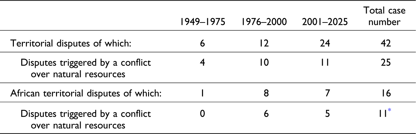
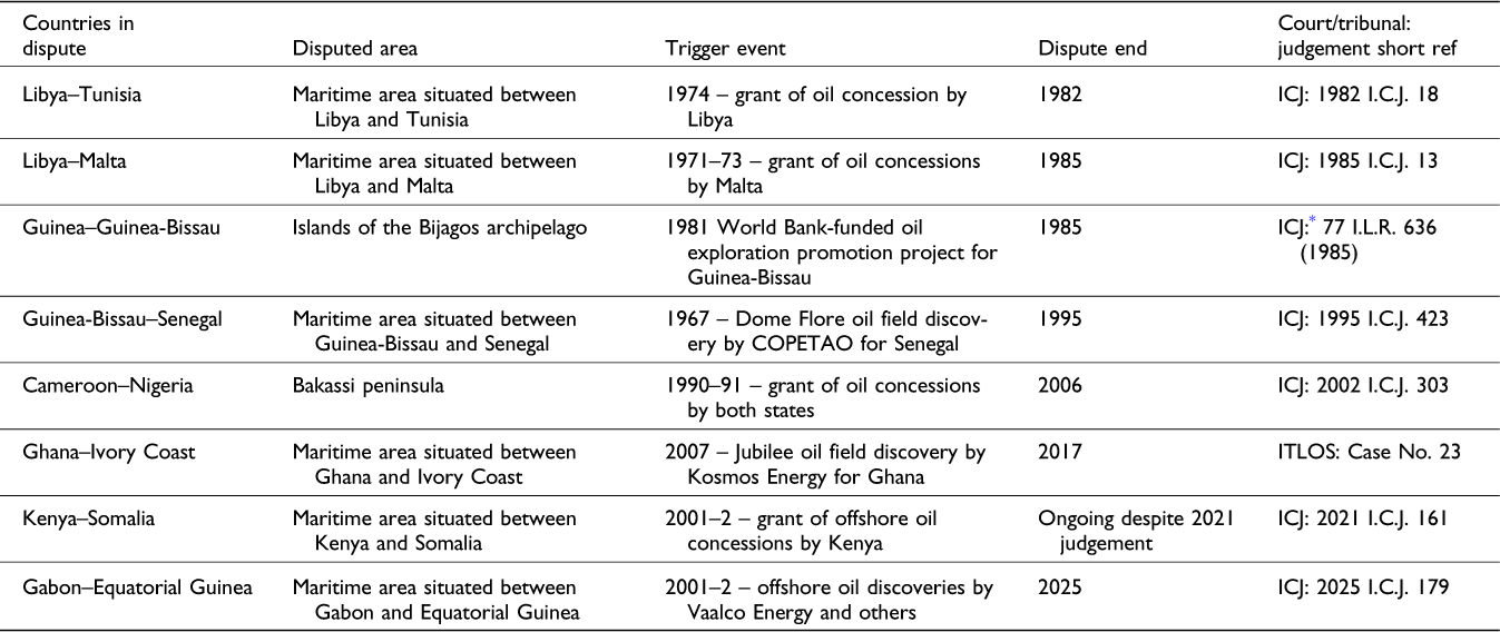
We found 42 territorial disputes in the ICJ and ITLOS courts for the period 1949–2025, of which 25 cases – equivalent to 60% – involved territorial disputes triggered by natural resources (see Table I). We found 16 court cases involving African territorial disputes, including 10 cases – equivalent to 63% – where oil and gas resources acted as triggers to the boundary dispute. The first African territorial dispute triggered by oil and gas was adjudicated in 1982 (Tunisia v. Libya), and the last was adjudicated in 2025 (Gabon v. Equatorial Guinea). In addition, we found one arbitration case presided by ICJ judges (Guinea v. Guinea-Bissau) and 14 CLCS submissions related to oil-triggered boundary delimitation.Footnote 1 Table II briefly summarises the most relevant cases adjudicated by the ICJ and ITLOS.
Territorial disputes in ICJ and ITLOS litigation, 1949–2025

* 10 disputes related to oil and gas and one dispute related to a dispute over fishing rights.
Source: Compiled by the author from ICJ and ITLOS legal documents and other sources.
Legal disputes triggered by the anticipation of oil and gas resources

* In contrast to the ICJ and ITLOS court cases, this was an arbitration tribunal presided over by three ICJ judges.
Abbreviations: COPETAO – Compagnie des Pétroles Total Afrique de l’Ouest; ICJ – International Court of Justice; ITLOS – International Tribunal for the Law of the Sea.
Source: Compiled by the author from ICJ and ITLOS legal documents and other sources.
In the next section, we present three short case study vignettes to demonstrate how the anticipation of future natural resource revenues triggered territorial boundary disputes in Africa. Our evidence suggests that the anticipation of oil and gas revenues played a key role in the evolution of disputes involving maritime boundaries – these boundaries were typically considered of little political or economic importance until the potential presence of oil and gas resources was signalled. The anticipation of oil and gas resources played a more ambiguous role – albeit it acted as an important contributory factor – in long-standing historical disputes over land boundaries between the two states. We will use the Guinea–Guinea-Bissau dispute as an exemplar of the former and the Nigeria–Cameroon dispute as an exemplar of the latter. Both of these disputes were settled by ICJ judges. We will also briefly present the Ghana–Ivory Coast dispute – the only example of a relevant dispute adjudicated by ITLOS.
Guinea–Guinea-Bissau maritime boundary dispute
According to the arbitration tribunal ruling on this dispute, the origins of the dispute could be traced back to the late 1950s. Until then, both France (Guinea’s former colonial power) and Portugal (Guinea-Bissau’s former colonial power) operated under an 1886 convention for the delimitation of their respective possessions in West Africa. The arbitration tribunal noted that ‘its implementation [of the 1886 convention] caused no difficulty until 1958. At that time, Portugal granted an oil concession [to Esso, a subsidiary of Exxon]’.Footnote 2 Already by 1959, France and Portugal engaged in discussions over the delimitation of maritime boundaries (Aquarone Reference Aquarone1995: 414). According to McLlarky (Reference McLlarky1987), the 1959 meeting was reportedly triggered by the possibility that oil deposits may exist off the Guinean coast. She pointed out that the primary focus of the meeting was to avoid granting overlapping oil concessions (McLlarky Reference McLlarky1987: 94). While the maritime boundaries remained disputed until 1985, both countries unilaterally decreed their territorial sea jurisdiction and exclusive economic zones (EEZ) and awarded offshore oil licences to foreign oil companies.
As Aquarone (Reference Aquarone1995: 414) argued, ‘offshore oil was at the centre of the disagreement’ between the two states. In January 1980, Guinea granted an oil exploration permit to Union Texas Petroleum Corporation, which covered a large geographical area that extended into the territorial waters claimed by Guinea-Bissau (McGrew Reference McGrew1981). Following this announcement, Guinea-Bissau began to engage in an effort to attract foreign oil companies to undertake oil exploration (Young Reference Young1984). In January 1981, the World Bank approved an oil exploration promotion project for Guinea-Bissau. As part of it, contracts were signed with private companies for consultancy services (which included geological report writing) and for oil exploration activities (which included a seismic study completed in early 1981), as well as support for revising the country’s legal framework and for promoting oil licencing. This work indicated the possibility of a major transboundary oil deposit in the offshore area claimed by the two states. A World Bank-funded promotional seminar in November 1981 resulted in the signing of an exploration contract with a group of international oil companies led by the French oil major Elf Aquitaine (World Bank 1983, 1992). By 1981, the presence of suspected natural resources thus became a driving force in the maritime dispute.
Under pressure from the oil companies to settle the dispute, the two states decided to seek arbitration in 1983. In February 1985, the case was decided by an arbitral tribunal composed of three judges from the ICJ. We can clearly say that the boundary dispute was driven by the active anticipation of potential oil and gas revenues. Ironically, no oil was subsequently found in the area (Aquarone Reference Aquarone1995).
Nigeria–Cameroon Bakassi Peninsula dispute
Nigeria and Cameroon disputed several different areas along their border, including the Lake Chad area, the Bakassi Peninsula and the maritime boundary between the countries. At independence, both states inherited land boundaries, which had been defined, albeit not properly demarcated, by various agreements between the colonial powers. Furthermore, the maritime boundaries were not clearly delineated. We focus here on the dispute over the Bakassi Peninsula, which led to violence and ICJ litigation in the 1990s. In contrast to the disputed Lake Chad area, the Bakassi Peninsula was believed to have considerable oil resources.
According to the ICJ judgement on this dispute, the conduct of both countries until the early 1990s suggested that the ownership of the Bakassi Peninsula by Cameroon was accepted by both sides. Notably, the court noted that ‘when Cameroon and Nigeria participated from 1971 to 1975 in the negotiations [over their maritime boundary’] leading to the Yaoundé, Kano and Maroua Declarations, with the maritime line clearly being predicated upon Cameroon’s title to Bakassi’.Footnote 3 The court further remarked that ‘this common understanding of the Parties is also reflected by the geographic pattern of the oil concessions granted by the two Parties up to 1991’.Footnote 4 Conversely, Nigeria’s counter-claim to the ICJ in May 1999 stated that, ‘apart from the incident of 1981’ [when a Nigerian patrol opened fire on a Cameroonian vessel off the coast of Bakassi], ‘the cordial relationship between Nigeria and Cameroon continued until the early 1990s, when Cameroon decided to force the issue over Bakassi’.Footnote 5
In the late 1980s, a number of oil discoveries were made offshore to the South of the Bakassi Peninsula. The French oil company Elf made a discovery at the Itindi Marine-3 oil field in 1986 (part of the Boa Bakassi oil concession) and started the development of the Biboundi oil field in 1987 (part of the Ekoundou concession) – both located in the Rio del Rey Basin offshore the Bakassi Peninsula and in the proximity to the maritime boundary with Nigeria (Hartman Reference Hartman1987; Hartman & Walker Reference Hartman and Walker1988). On the Nigerian side of the offshore maritime boundary with Cameroon, the US oil company Ashland started to operate six new offshore oil fields in the late 1980s (the blocks were later taken over by a politically well-connected Nigerian firm Addax Petroleum) – which may have also contributed to the optimism over oil prospects (Anonymous 2003). By the early 1990s, both Cameroon and Nigeria had significantly intensified their oil exploration efforts. In 1989, Elf obtained the renewal of several oil permits in the Rio del Rey Basin. In 1990, the Cameroonian government awarded new oil concessions in the Rio del Rey Basin to Elf. In parallel, the Nigerian government started to engage in the discretionary award of new oil concessions during 1990–1991, and – for the first time since independence – the government awarded production-sharing contracts and oil concessions to indigenous Nigerian companies. This included concessions in the offshore areas near the Nigeria–Cameroon border, most notably block OPL 224 (later re-named OML 115) awarded to the newly formed Oriental Energy Resources Limited (owned by Nigeria’s billionaire Muhammadu Indimi) in September 1990; in the following year, the company entered into an agreement with the US multinational DuPont, which paved the way for the start of oil exploration (Olawoyin Reference Olawoyin2018).
The award of oil concessions by both countries – linked to heightened expectations of future oil wealth – explains the timing of the flare-up of the dispute over the Bakassi Peninsula. After several border skirmishes during 1992–1993, Nigeria ordered a massive military build-up and invaded a part of the Bakassi Peninsula in December 1993, with reportedly over 50 Nigerian soldiers and some civilians killed (Evans & Merrills Reference Evans and Merrills1997; de Koning & Mbaga Reference de Koning and Mbaga2007; Anonymous 1994). As both countries faced the prospect of a full-out war, Cameroon filed a legal suit with the ICJ in March 1994 (Anyu Reference Anyu2007). In March 1996, the ICJ called on both sides ‘for the cessation of all hostilities in the Bakassi Peninsula’.Footnote 6 Throughout the dispute in the 1990s, the concern of both the Nigerian and the Cameroonian governments over oil resources was evident, as exemplified by Nigeria’s Minister of Defence, General Theophilus Danjuma, who sent naval reinforcements to the Bakassi Peninsula in December 1999, reminding soldiers that ‘you must endeavour to provide security to all oil companies prospecting for oil and gas in the area‘ (PostExpressWired, 5 December 1999). The boundary dispute was clearly driven by the anticipation of potential future oil and gas revenues. In 2002, the ICJ made a final judgement on the dispute and awarded most of the disputed area to Cameroon, which was confirmed in a bilateral agreement between the two countries in 2006.
Ghana–Ivory Coast maritime boundary dispute
According to the ITLOS judgement on this dispute, while ‘Côte d’Ivoire informed Ghana of a delimitation dispute, the precise date when such information was provided remains unclear’.Footnote 7 The Ivory Coast representatives claimed that the country did not previously object to the maritime boundary between the two countries because it ‘suffered from internal conflicts following the death of President Houphouët-Boigny in 1993’.Footnote 8 However, as Ghana’s representatives accurately pointed out, the Ivory Coast had functioning state institutions throughout this time, and indeed, ‘it granted concessions, amended its petroleum and tax laws and engaged extensively with the international petroleum industry and its neighbour Ghana’.Footnote 9 Looking at the evidence in front of them, the ITLOS judges pointed to February 2009 as the date of the first proposal by the Ivory Coast for a maritime boundary delimitation.Footnote 10
As Bening (Reference Bening2014) argued, the Ghana–Ivory Coast boundary dispute ‘is really a territorial dispute over the ownership of known natural resources in the territorial sea’. According to one legal expert, Ghana and the Ivory Coast ‘showed little urgency in delimitating the boundary line following independence, but this changed upon the discovery and subsequent exploration of offshore petroleum resources in the now-disputed area’ (Cappellazzo Reference Cappellazzo2016). The direct trigger of the boundary dispute was the discovery of the Jubilee field by the US firm Kosmos Energy in 2007, which was reported to have estimated reserves of 700 million barrels of oil and 800 billion cubic feet of natural gas. The hype over future extractive income was further amplified after the discovery of the TEN field by a consortium led by the Irish firm Tullow Oil in 2009 – the TEN oil field was located in an area that Ivory Coast claimed as part of its EEZ in 2011 (Skaten Reference Skaten2018). The Ivory Coast specifically asked ITLOS for compensation ‘both for the loss of hydrocarbon production and for any damage that Ghana’s activities may have caused to rocks and deposits’.Footnote 11
The ITLOS judges noted that proposals by the Ivory Coast for resolving the dispute added further ambiguity. In February 2009, the government of Ivory Coast proposed a delimitation based on a meridian. In May 2010, it suggested a different meridian. In November 2011, it shifted its position again and advocated the application of the angle bisector method. The line proposed in 2011 was once again modified in May 2014. According to the ITLOS judgement, ‘the application of these different methods of delimitation resulted in disputed areas the location and size of which differed’.Footnote 12 The changing views of the Ivorian government, like the boundary dispute, were clearly driven by the anticipation of potential future oil and gas revenues.
In April 2009, Ghana lodged a claim with the UN CLCS, but the commission did not resolve the dispute. In September 2014, arbitral proceedings between the two countries started, and then both countries concluded a special agreement to submit the maritime boundary dispute to a special chamber of ITLOS. In 2017, the ITLOS made a final judgement on the dispute, confirming that Ghana did not violate Ivory Coast’s exclusive sovereign rights and that the TEN oil field was situated inside Ghana’s EEZ.
Peaceful resolution of boundary disputes?
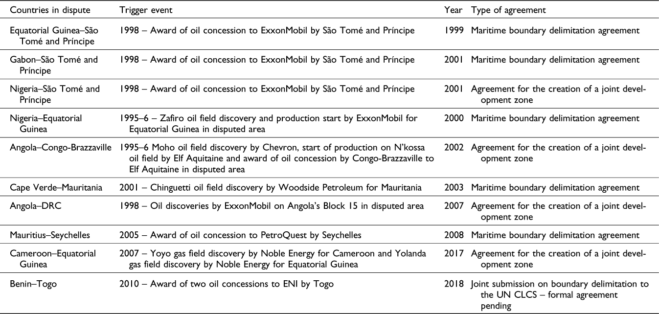
There are some examples of international boundary disputes that were resolved entirely through bilateral negotiations and agreements between the two states. The award of oil exploration licences and natural resource discoveries still acted as triggers for many disputes. However, in some cases, the two states in a dispute were able to negotiate a treaty to delimit their boundary, as in the case of the dispute between Equatorial Guinea and STP in 1999. In other cases of maritime boundary disputes, the two states agreed on the joint development of transboundary natural resources instead of delimiting the actual boundary line. For example, in the dispute between Nigeria and STP, the initial negotiations between both states failed, as there was no agreement on the terms of the delimitation of the maritime area. A joint development zone (JDZ) was then created between Nigeria and STP in 2001 (see Table III). The ability of two states to strike such a bilateral agreement pre-empts the risk of armed clashes or a protracted international legal dispute. This raises the question whether these agreements reflect a shift towards more peaceful resolution of international boundary disputes in Africa in recent decades, and if this is the case, what factors may explain the greater likelihood of the peaceful resolution of disputes.
Bilateral maritime agreements linked to the anticipation of oil and gas resources

Source: List compiled by the author derived from formal submissions to the CLCS and other sources.
In general terms, international relations studies have suggested that, in the late 20th century, the use of force has become less common in interstate disputes, that interstate disputes have become more likely to be resolved through international interventions and that there was a growing respect for the proscription that force should not be used to alter interstate boundaries (Carlsson Reference Carlsson1992; Zacher Reference Zacher2001; Goldstein Reference Goldstein2011). Similar arguments have been made with reference to Africa, with scholarship suggesting that large-scale organised political violence in sub-Saharan Africa has declined (most notably, Straus Reference Straus2012).
However, a peaceful resolution of territorial conflicts cannot be taken for granted. For example, the Angola–DRC territorial dispute has continued notwithstanding the creation of a joint oil and gas development zone in 2007 (Anonymous 2009; Edmond et al. Reference Edmond, Titeca and Kennes2019). Similarly, more recently, the Kenya–Somalia maritime dispute has continued despite a final judgement by the ICJ in 2021, which provided a legally binding court judgement based on the ‘equidistance’ boundary line between the two countries. Kenya rejected the UN court judgement and continued to explore for oil and gas in the disputed maritime area, which the ICJ awarded to Somalia (Muiruri Reference Muiruri2021).
So why are some disputes settled while others continue? Resource curse studies suggest that resource curse effects are subject to a number of contingencies and that the impact of natural resources on conflict is conditional upon three key variables: governance, ethnic identity and geographical location of natural resources. In other words, research suggests that good governance, ethnic homogeneity and the offshore location of natural resources reduce the likelihood of societal conflicts (Lujala Reference Lujala2010; Esteban et al. Reference Esteban, Mayoral and Ray2012; Mehlum et al. Reference Mehlum, Moene and Torvik2006; Robinson et al. Reference Robinson, Torvik and Verdier2006). In line with this literature, we will briefly consider to what extent the location of resources, ethnic identity and the nature of governance may or may not have helped towards the peaceful resolution of international boundary disputes in Africa.
Starting with the most obvious argument, resource curse scholarship suggests that the location of natural resources plays a key deciding factor for conflicts. If natural resources are located inside the actual conflict zone, a conflict can be significantly exacerbated, as the stakes become even higher for both conflict sides. Alternatively, the resource curse effects on conflict are said to be less likely if oil and gas deposits are found offshore (Lujala Reference Lujala2010; Ross Reference Ross2014). Indeed, all international boundary disputes that were peacefully resolved through bilateral agreements (Table III) relate to maritime boundaries and offshore natural resources. In other words, there were no previous political conflicts over these areas, and there were no apparent groups that had a vested prior interest in the conflict. Paradoxically, while the presence of natural resources may trigger maritime disputes between states, at the same time, it may then provide an incentive to settle a dispute, as both sides may be unable to draw economic benefits from the oil wealth until the dispute is settled. In previous international boundary disputes in Africa, oil companies often reduced investments or even suspended operations on various occasions, either because they were concerned about uncertain ownership rights, or because they were concerned about security, or because an international court or tribunal imposed limitations on economic activities in the disputed area. For example, in the Libya–Malta dispute, Maltese exploration boats were prevented from operating in the area due to the fear of Libya’s military boats, while in the Ghana–Ivory Coast dispute, ITLOS imposed limitations on oil drilling in the disputed area. In other words, neither side to the dispute was able to draw economic benefits until a peaceful solution was found.
However, the geographical location of oil and gas has not prevented territorial conflicts. Earlier conflicts over maritime boundaries, such as the Libya–Malta dispute and the Senegal–Guinea-Bissau dispute, were tense and acrimonious. In the recent Kenya–Somalia maritime dispute, the Italian oil company ENI (formerly Agip) decided to continue to explore for oil on behalf of Kenya in the disputed area awarded by the ICJ to Somalia in 2021. On the one hand, Kenya’s government saw it in the country’s self-interest to ignore the ICJ judgement, and on the other, a foreign oil company was prepared to drill for oil despite the obvious illegality of such a decision.
Resource curse scholarship suggests further that the presence or absence of ethnic divisions and polarisation presents an important contingency in resource conflicts (e.g. Brunnschweiler & Bulte Reference Brunnschweiler and Bulte2009; Herbst Reference Herbst2000). For example, the long-standing dispute over the Bakassi Peninsula with Cameroon was caused by historical divisions that can be traced back to the colonial era: the Bakassi Peninsula was inhabited by Anglophone populations, but the region was put in Cameroonian territory in colonial times, and separatist ethnic movements in the Bakassi Peninsula have continued to date (Anonymous 2020). In marked contrast, Nigeria’s dispute with STP over their maritime boundary – where significant future oil income was anticipated – was resolved by signing an agreement for a JDZ in 2001. The dispute did not involve any previous ethnic or other historical conflicts. The ensuing compromise for the JDZ agreement between Nigeria and STP served as a role model for the resolution of other international boundary disputes in West Africa’s maritime areas. As an added peace incentive for Nigeria’s government, some companies linked to Nigeria’s vice-president were reportedly hoping to benefit from future oil resources in the area (Frynas et al. Reference Frynas, Wood and Hinks2017). However, the absence of ethnic conflicts did not always help to peacefully resolve conflicts, as various maritime boundary disputes continued and the use of force in some previous boundary disputes could not be linked to any ethnic factionalism – such as the Malta–Libya boundary dispute.
Resource curse studies also argue that good governance may help reduce resource curse effects including societal conflicts (e.g. Besley & Prat Reference Besley and Prat2006; Haslam Reference Haslam2016; Mehlum et al. Reference Mehlum, Moene and Torvik2006). At the same time, international relations scholars argue that improved conflict-resolution mechanisms may help to reduce conflicts over natural resources in Africa, including international initiatives such as the UK’s Africa Conflict Pool, UN peace missions and African regional peace mechanisms (e.g. Reno Reference Reno2012; Straus Reference Straus2012). However, such interventions have regularly failed when at least one of the sides to the conflict did not consider it in their self-interest to discontinue the territorial dispute. For example, the UN CLCS was asked to mediate in the Ghana–Ivory Coast and the Kenya–Somalia boundary disputes in 2009, but it failed to resolve the disputes, and both cases were later brought to international courts (ITLOS and ICJ, respectively). Likewise, a mediation team of the Africa Forum (which included former Mozambican president Joaquim Chissano and other African presidents) tried to help settle the ongoing Malawi–Tanzania boundary dispute during 2014–2017, but it failed to do so (Kenneth Reference Kenneth2016). In other words, the proliferation of conflict-resolution mechanisms cannot resolve international boundary disputes by itself.
Lessons learned and conclusions
Our evidence suggests that the anticipation of future oil and gas revenues played a very important role in the evolution of international boundary disputes in Africa. We found that 10 out of 16 African territorial disputes in international courts were triggered by a dispute over anticipated oil and gas resources. Anticipation of future oil and gas was the key driving force behind most maritime boundary disputes in Africa, but it also helped intensify existing historical disputes over onshore boundaries. Our study provides support for the presource curse thesis, specifically for the impact of the anticipation of future extractive revenues on territorial disputes between countries where such future revenues are expected. It is the first study that specifically investigates the impact of the presource curse on international relations.
Theoretically, we can explain the presource curse mechanisms behind international boundary disputes on the basis of recent future-oriented sociology as well as signalling theory. Based on the concept of the ‘economy of anticipation’ derived from sociology (Cross Reference Cross2015), a recent study on the presource curse pointed to the importance of a time lag between expectations of future extractive revenues (cognitive processes related to expectations about some kind of future outcome) and anticipation of future extractive revenues (related to tangible actions when such expectations are acted upon, where decision-making is directed towards the future) (Frynas & Buur Reference Frynas and Buur2020). As an illustration, the boundary dispute between Guinea and Guinea-Bissau started in the late 1950s following the award of an oil concession in the disputed area (there were limited expectations of possible future extractive revenues), but an escalation of the dispute followed by a serious attempt to resolve the dispute only took place in the early 1980s following credible reports of substantial transboundary oil deposits (which triggered action-oriented anticipation in the form of national policy responses).
Scholarship on the presource curse suggests that the signing of a contract with a foreign extractive company (Frynas et al. Reference Frynas, Wood and Hinks2017) and a reported extractive discovery (Cust & Mihalyi Reference Cust and Mihalyi2017) represent the two crucial types of trigger events that lead to a presource curse. In our sample of boundary disputes, we found both types of trigger events (see Tables II and III). We extend the current typology by adding a third type of trigger event: a publicly funded exploration promotion campaign. In the case of the Guinea–Guinea-Bissau dispute, a World Bank-funded promotional project provided credibility to the narrative about presumed oil riches in Guinea-Bissau’s offshore waters, which helped to attract private companies and, in turn, helped to trigger the boundary dispute. With all three types of trigger events, the involvement of trusted foreign actors was crucial (such as the World Bank or foreign oil companies). Theoretically, we would suggest that ‘signalling theory’ can explain this process (Connelly et al. Reference Connelly, Certo, Ireland and Reutzel2011). During oil and gas exploration, information asymmetry between oil companies and other actors (investors, government regulators, local communities) is enormous, which raises the importance of sending effective signals (i.e. providing selected key information about oil exploration) to these actors. The three types of trigger events act as crucial signals for both the state and private actors, by lending credibility to narratives about future resource booms and potential future extractive revenues – the extent of credibility of these signals decides on triggering action-oriented anticipation. Whenever such credible signals relate to geographical areas with imprecisely delineated or undelineated state boundaries, they are likely to trigger competing ownership claims in a boundary dispute between states.
While increased oil and gas exploration in Africa triggered international boundary disputes, our study also points to the likelihood of peaceful bilateral resolutions of such disputes. Gunboat diplomacy (e.g. Libya’s gunboat chasing away an oil exploration vessel offshore Malta in the 1980s) and the real risk of large-scale armed conflict over a disputed boundary (e.g. Nigeria’s military intervention on Cameroonian soil in the early 1990s, which risked an all-out war) would appear to be less likely in Africa today. However, despite international litigation in the ICJ and despite African peace-resolution mechanisms, some territorial disputes continue, and some governments are prepared to ignore court judgements and mediation attempts. Once again, expectations of future oil and gas developments are crucial. In some cases, two governments have major incentives to cooperate in the name of jointly developing natural resources (e.g. Nigeria and STP), whereas in other cases, one government may decide that a peaceful agreement would render the future exploitation of natural resources less profitable (e.g. Kenya and Somalia).
Kenya provides an interesting recent example. Kenya’s government refused to accept the ICJ judgement in 2021 because it would prevent the country from prospecting for oil in the disputed area. Furthermore, the Italian oil company ENI was prepared to risk engaging in an illegal operation under Kenya’s protection. However, subsequently, ENI failed to find any commercial oil resources in the disputed area, and Kenya’s interest in the disputed area has recently decreased (Mutua Reference Mutua2022). In other words, without the realistic prospect of future oil riches, there would probably be no dispute between the two countries in the first instance, and without the anticipation of future oil riches, the dispute may eventually be settled.
Unfortunately for Africa, oil and gas resources have played a role in several long-standing violent conflicts on the continent, and the implied threat of the use of force in international boundary disputes remains palpable. Indeed, the peaceful resolution of some oil-triggered boundary disputes in Africa may have been induced by the fear of a dominant neighbour by the weaker neighbour – as in the case of the Angola–DRC dispute, with concerns in the DRC over Angola’s military power (Edmond et al. Reference Edmond, Titeca and Kennes2019), and the Seychelles–Mauritius dispute, with concerns in Mauritius over India’s dominance (Wikileaks 2006). As there are still many unsolved territorial boundary disputes in Africa, we need to gain a better understanding of the contingencies that influence the evolution of competing boundary claims, and we need to acknowledge the negative role that natural resources and foreign oil companies play in Africa’s conflicts. This article hopefully makes a small contribution to this understanding.

 Open access

