


Introduction
Footnote 1 Words change and borders shift. ‘Tibet’ is no exception in this regard. Previous scholarship has already highlighted the flexibility in the usage of the Tibetan word Bod—the toponym widely translated as ‘Tibet’—in historical texts. Bialek, for instance, has recently brought to light the word’s early history as reflected in Old Literary Tibetan sources, which saw it develop from a minor regional demonym to a mighty empire’s preferred endonym.Footnote 2 Tuttle has argued that, in later centuries, the geographic denotation of the term underwent a gradual expansion along with a north-eastward shift of its centre of gravity.Footnote 3 Yet, despite such insights, Bod is still often casually translated without regard for such fluctuations, perhaps precisely because these shifts in usage have not been thoroughly explored.
A most welcome contribution by a historical geographer is telling in this regard. Ryavec’s valuable historical atlas maps the Tibetan Plateau from a variety of perspectives and across time periods, yet does not treat Bod itself as the subject of substantial change. For one, it largely takes for granted Tibet’s ‘traditional’ threefold division into Dbus-Gcaṅ, Mṅaɣ-ris, and Mdo-khams during the historical period.Footnote 4 However, present-day understandings of the toponym Bod and of its English counterpart, too, can differ substantially from those of composers of centuries past. Historical authors among themselves also entertained or presented radically different notions of the size of Bod, as we shall see. An issue of substantial interest therefore tends to get lost in translation, namely how a pivotal toponym—intimately connected to notions of cultural, historical, political, national, and ethnic community—expanded and contracted across works, as well as over time and space.
In a bid to throw light on this subject, this article presents textual analyses of the toponym Bod as it appears in five Classical Tibetan (CT) primary sources. The selected Tibetan worksFootnote 5 represent a variety of genres and include an encyclopaedia, two royal chronicles, a genealogy, as well as a ‘treasure text’ (gter ma, an allegedly ancient work reportedly recovered again later in time). These works are, in their order of discussion: the Pillar Testament (Bkaɣ čhems ka khol ma), the Singular Volume of the Rlaṅs [Clan] (Rlaṅs kyi po ti bse ru), the Treasury of Explanations, a Wish-Fulfilling Jewel (Bśad mȷod yid bźin nor bu), the Canopy of Everlasting Joy (Skyid paɣi g.yuṅ ruṅ du gdugs brdal ma), and the Royal Chronicle of Ladakh (La dwags rgyal rabs).Footnote 6 These works cover a time frame from roughly the twelfth to the seventeenth centuries, and their texts’ geographic provenance spans from Ladakh in the western Himalaya to Khams in the east.
Relevant passages from these works shed light on the extent of Bod in a variety of ways. Some explicitly mention the existence of defined borders, occasionally with their precise locations. Others detail itineraries that lead from some place into Bod, and thus indicate the (rough) whereabouts of a perceived frontier or border. The usage of first-person personal pronouns in combination with Bod, as found in one source, demonstrates the author’s personal affiliation of his region with Bod. (Rarely, and with due care, even proximal demonstrative pronouns can be interpreted to the same effect.) In yet other passages, ‘Tibet’ is separated from another territory, indicating its adjacency to that land and hence their border, or it may be split into named constituent regions, thus identifying the regions that ‘Tibet’ subsumes and thus its extent. Yet elsewhere, the association of identifiable numina with the landscape of ‘Tibet’ signals the inclusion of that numen’s locality in the territory of Bod.
Taken together, these works provide a more complicated picture of the extent of Bod than has previously been available. Rather than finding a territory that gradually expanded and whose centre shifted east (with north-eastern territories eventually included at the expense of the west),Footnote 7 we obtain a far more haphazard impression. Not only do roughly contemporaneous sources display remarkable differences, but even individual works can be inconsistent in the image they forward of Bod’s geographic extent.
The appearance of differently sized ‘Tibets’ in a single work sometimes reflects a methodological hurdle that we would be wise to contemplate at the outset. Some compositions under consideration were, certainly in part, pasted together from disparate (and often unacknowledged) sources, or were edited or extended as time passed, and may thus refract different understandings of Bod throughout their pages. We have tried to mitigate, or at the very least highlight, such issues throughout the article, such as by building on previous text-historical research or by consulting multiple witnesses so as not to lend undue weight to an obvious interpolation or scribal error.Footnote 8 Still, the reader is advised to bear in mind that any specific image of ‘Tibet’ that appears in a passage certainly need not reflect the personal understanding of the work’s original author or compiler.
On a final note, we wish to stress some of the conceptual limits of this article, as we largely restrict ourselves to matters of geographic perceptions as recoverable from individual literary sources. The bulk of the research therefore does not speak to issues of political authority, nor to matters of ethnic or national belonging on the ground, all of which may depart radically from literary conceptions of a toponym. In their variety and limited number, moreover, our findings do not, or at least do not yet, allow easy conceptual unification. Finally, while considerable detail is presented on the perceived eastern and western frontiers of ‘Bod’, the selected sources are mostly silent about the south or, for that matter, the north. The research results presented here should accordingly be seen as stepping stones towards a more comprehensive review, not as an exhaustive study.
The Pillar Testament: Bod as the Four Horns
The Pillar Testament (Bkaɣ čhems ka khol ma) is a famous early second-millennium Buddhist source on the dawn of the Tibetan empire, often cited and adduced in Tibetan literature. Traditionally attributed to the Tibetan Emperor Khri Sroṅ-bcan Sgam-po (?–649), it is said to have remained hidden for centuries before it was recovered by the missionary Atiśa/Adhīśa in the mid-eleventh century. Regardless, the redactions available today likely do not predate the twelfth century. Below, we first look at the most extensive extant redaction (preserved in witnesses M and S), which, in its current form, was compiled no earlier than the thirteenth century, and perhaps even as late as the fifteenth century.Footnote 9 Although this redaction yields most material of relevance, more conservative redactions of the work are also adduced to confirm that the understanding of ‘Bod’ in the largest redaction is indeed representative of the Pillar Testament’s broader textual tradition.
Much of interest can be found in the chapter that details the invitation of the Tang Princess Mun-čhaṅ koṅ čo (Ch. 文成公主 wénchéng gōngzhǔ), in which the emperor Khri Sroṅ-bcan dispatches a Tibetan mission to obtain a royal bride from the Chinese imperial court. This chapter details multiple travels between the Tibetan and Chinese courts, and offers clear evidence that substantial parts of what is presently known as Khams,Footnote 10 on the eastern Tibetan Plateau, were excluded from Bod. Consider the following passage:
(1) Prior to the point of the month at which [Mun-čhaṅ koṅ čo] would arrive in Bod, [she] carved in bulging relief the first section of the large [Prajñāpāramitā-sūtra] and the Bhadracaryāpraṇidhāna into [the rock face of] Brag-sṅon Rci-dkar-čan, in Ldan-ma,Footnote 11 in Khams.bod du ɣoṅ baɣi zla baɣi dus chod ma thems kyi bar du/ khams su ldan maɣi brag sṅon rci dkar čan la rgyas paɣi dbu dum daṅ/bzaṅ po spyod paɣi smon lam ɣbur du btod pa brkos nas bris/ (Pillar Testament M: 185.18–186.1; S: 154.18–20)
Prior to the princess’s arrival in Bod, she was active in Ldan-ma, which is thus clearly excluded from Bod itself.
The geographic partition of sizeable areas of the eastern Tibetan Plateau from Bod is also evident in another passage, which mentions a valley system in southern Khams. The fabled Tibetan minister Mgar, in a clever ruse to escape from captivity at the Chinese court, convinces the Chinese emperor to let him travel westbound to propitiate deities of the Tibetan landscape:
(2) [Mgar and his guards] arrived at Rgyal-mo Cha-ba-roṅ. There, [he] bought much meat and barley beer and went to a spot from where one could see the mountains of Bod.Footnote 12 The minister said [to his guards]: ‘That is [the mountain] known as lha ri Gyaṅ-mtho. It is a great site for propitiating the lha.’rgyal mo cha ba roṅ du sleb bo/ /der śa čhaṅ maṅ po ños nas bod kyi ri mthoṅ baɣi sar phyin nas/ blon po na re ɣdi ni lha ri gyaṅ mtho bya ba yin pas/ lha gsol sa čhen po yin no zer nas (M: 192.5–7, S: 160.5–8)
Although Mt. Gyaṅ-thoFootnote 13 is considered part of Bod, this clearly does not hold for Rgyal-mo Cha-ba-roṅ itself—the valley system that stretches north-west from Mt. Kha-ba-dkar-po at the contemporary border between the Tibetan Autonomous Region (TAR) and Yunnan. Indeed, when, earlier in the narrative, the Chinese emperor consented to minister Mgar’s travel plan, he sent four guards along out of fear ‘that the minister would flee to Bod’ (blon po bod du śor gyis dogs nas, M: 191.2, S: 159.6–7), confirming that Mgar’s captors would never allow him to travel into Bod itself. The region north-west of Kha-ba-dkar-po, then, is perhaps considered an intermediary space, but certainly not a part of Bod.
A similar picture incidentally emerges from the fourteenth-century treasure text Padma bkaɣ thaṅ.Footnote 14 In that work’s 77th chapter, Vairocana is banished to the same region of Rgyal-mo Cha-ba-roṅ. He subsequently speaks to the local monarch about Bod, along with its ruler, as if it were an altogether foreign country.Footnote 15
The Pillar Testament’s geographic conception of Bod also comes to the fore in its explicit equation of Bod with the territory of the Four Horns of the Tibetan empire:
(3) Minister Mgar instructed the subjects of Bod: ‘… fix all the troublesome mountain and valley paths, all over, and make them comfortable [for travel]!,’ [he] said. The people of the entire kingdom of Four-Horned Bod-Dbus-Gcaṅ restored all [their respective] local paths to good condition. blon po mgar gyis bod ɣbaṅs rnams la bsgo ba (…) ri daṅ kluṅ gi lam mi bde ba thams čad phyogs phyogs su čhos la bde bar gyis śig čes gsuṅs/ bod dbus gcaṅ ru bźiɣi rgyal khams thams čad kyi mi rnams kyis/ thad ka thad kaɣi lam thams čad bde bar bčos so/ (M: 199.4–9, S: 166.3–8)
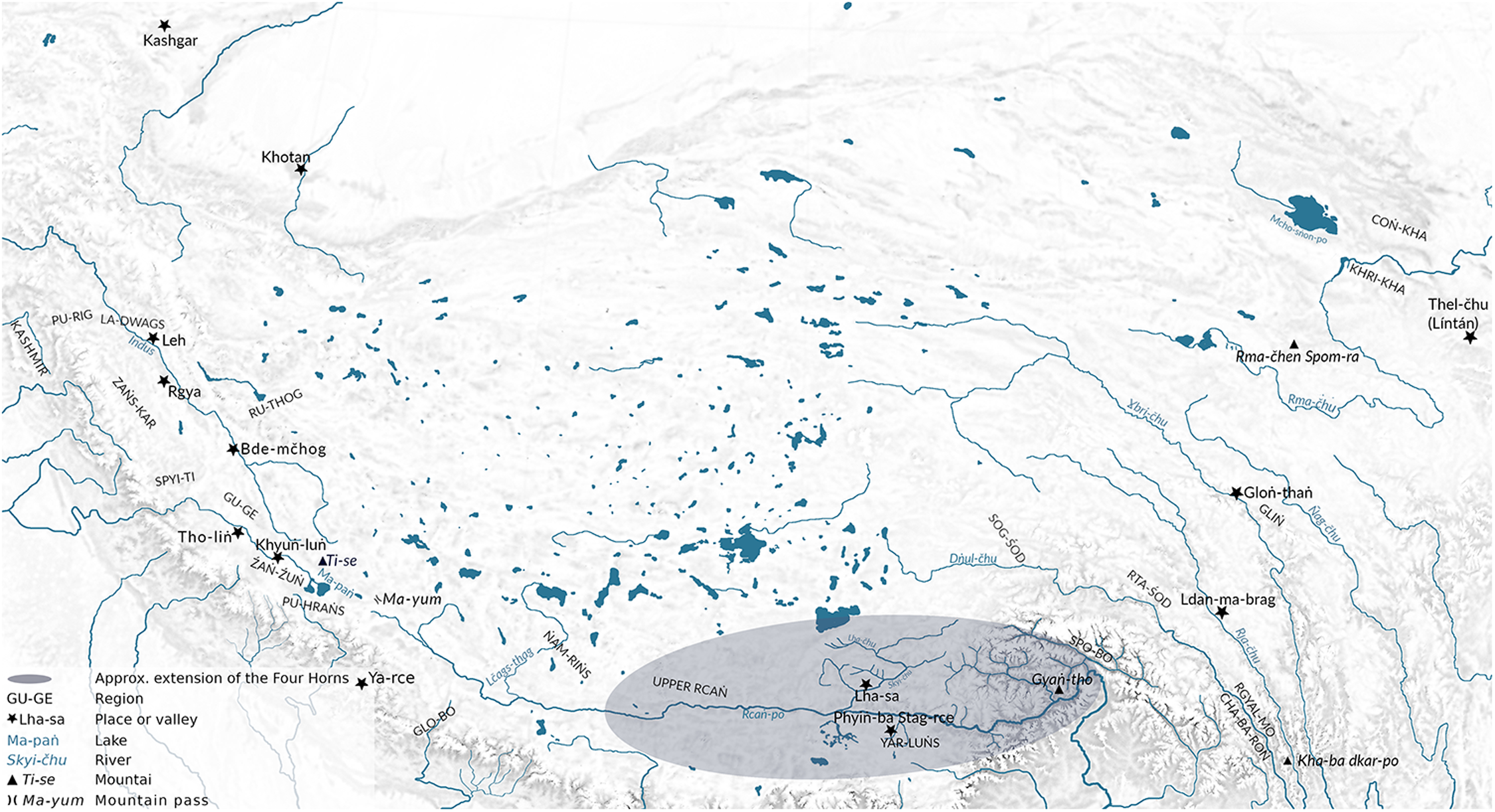
Here, the ‘kingdom’ (rgyal khams) does not extend past Bod-Dbus-Gcaṅ, referring to two major regions of the central Tibetan Plateau (Dbus and Gcaṅ), along with the Four Horns that they subsume. The mention of Dbus and Gcaṅ once again excludes Khams to the east. The territory of the Horns has been mapped by Hazod on the basis of Tibetan post-imperial historiographical sources.Footnote 16
This circumscribed geographic conception of ‘Bod’ is confirmed by other passages, too. After geomantic considerations establish that ‘the ground of the Snow-clad Bod Land’ (bod yul kha ba čan gyi sa gźi)Footnote 17 is like the prostrate body of a demoness, Emperor Khri Sroṅ-bcan and Princess Mun-čhaṅ koṅ čo realise that they must build ‘temples of the Four Horns’ (ru bźiɣi gcug lag khaṅ) in order to tame this troubling chthonic force. ‘The Snowy Bod Land’ therefore again coincides with the territory of the Four Horns (M: 233.15–234.3, S: 194.3–9).
Clearer still are passages in which the Bod Land is divided into these four territories. In the enlarged redaction under consideration thus far, this event occurs twice. The division is undertaken once by the ancestor of the Tibetan peopleFootnote 18 and then again under the rule of the early emperor Lha Tho-tho-ri Gñan-śel. This latter passage is most telling: ‘[the ruler] split the Bod Land into the Four Horns, and divided [it] into farmland and [other] land’ (bod yul ru bźir phye nas yul daṅ sa ru bgos so/ (M: 91.10, S: 76.8)). Such lines can also be found in the various other redactions of the work. In the seemingly most archaic extant redaction, for one, we read that, during the reign of an early emperor, the powers that be ‘divided Bod into Four Horns’ (… bod ru bźir phye//, D: 396.7). A line of the same substance appears in the same context in other redactions, too (P: 25a4, L: 675.1, N: 849.7). The overwhelming stance of the Pillar Testament tradition, in sum, seems to be that Bod consists of the Four Horns and nothing more.
Regardless, the space between Bod and China that includes Khams (or Mdo-khams)Footnote 19 is not always on the radar as a different country of note. In standard schemes, the eastern neighbour of Bod is forever ‘China’ (Rgya), and so it is in the Pillar Testament: ‘To the east of Snowy Bod is the realm of Rgya. To the west [of Bod] are the realms of Sum-pa, the Kathmandu Valley and Źaṅ-Źuṅ. To the north … [etc.]’ (bod kha ba čan gyi śar na rgya nag gi yul khams yod/ nub na sum pa daṅ/bal yul/ źaṅ źuṅ gi yul khams yod/ byaṅ na … (M: 201.11–13, S: 168.4–6)). However, we should not make too much of such formulaic geographic schemes of the lands surrounding Bod, as these are (so many versions of) old circulating stock phrases, and hence unlikely to reflect an author’s personal geographic perceptions. We obtain a far better sense of the frontier-like nature of the regions directly east of Bod in another passage, found in the generally most archaic redaction.
When the Buddhist temples of the Four Horns are erected, one of the temples listed is explicitly located in Khams, where it is constructed on the palm of the territorial demoness’s left hand. The site in question is situated as far away as the eastern bank of the Ɣbri-čhu river, well outside the realm of the Four Horns (see Figure 1) and outside of Dbus-Gcaṅ.Footnote 20 Clearly, the demoness identified with the Bod Land (and its Horn subdivisions) in fact stretches out beyond the boundaries of that same territory into Khams. As such, the passage seems to display the frontier-like quality of Khams, whose animated geography links up with that of Bod, even though the two regions are kept separate in toponymy.
The Tibetan Plateau with key toponyms discussed in the article.

The Singular Volume of the Rlaṅs [Clan]: beyond the Four Horns
The Rlaṅs kyi po ti bse ru or Singular Volume of the Rlaṅs [Clan] is the famous genealogical charter of the Phag-mo-gru Dynasty, which became the dominant ruling house on the central Tibetan Plateau in the mid-fourteenth century. Despite text-internal claims to an older date, the work was compiled in the late fourteenth or perhaps the early fifteenth century.Footnote 21 Compared with the Pillar Testament, the Singular Volume forwards a far more wide-ranging geography of Bod. In this work, Bod encompasses numerous locations that are far east of the Four Horns, and stretches farther to the west, too. Twice, moreover, we find mention of a direct border or frontier (mchams) with China.
First, the eastern polity of Gliṅ (see Figure 1), located to the north of Sde-dge, is presented as a constituent part of Bod. The ‘Lord of Gliṅ’ (gliṅ rǰe), Ge sar, visits a Buddhist master and ancestor of the Phag-mo-gru Dynasty, who is travelling in China. There, Ge-sar invites him to ‘come to the Land of Bod’ (bod kyi yul du ɣbyon par źu/ (I: 197.4, II: 92.3, IV: 58.9)). The master does not immediately take up the invitation, yet, when the master later announces that now ‘it is time to go to the Land of Bod’ (bod kyi yul du ɣgro ran yod/ (I: 201.5, II: 96.2, IV: 60.12–13)), he in fact travels to Gliṅ, where he meets with Ge-sar. Both the invitation and the travel announcement explicitly mention Bod, while the physical meeting takes place more precisely in Gliṅ, which is hence located within Bod.
The affiliation of Gliṅ with the larger region of Bod becomes clearer still. When Ge-sar addresses the master, named Byaṅ-čhub Ɣdre-bkol, he asks for ‘the increase of people and wealth of Gliṅ’, but also for the ‘well-being of the Bod Realm’ at large (gliṅ gi mi nor ɣphel ba daṅ/[…] bod khams bde ba thugs la thogs/ (I: 204.4–5, II: 98.4, IV: 62.4–5)). This is reiterated later on, when Ge-sar requests as follows:
(4) [Please] bear the happiness of the Bod Realm in mind.
This Empty Plain, [one] of the Eight Plains of Gliṅ,
I offer [as a site for] your hermitage, [o] accomplished one.
bod khams bde ba thugs la thogs/ gliṅ gi thaṅ brgyad thaṅ stoṅ ɣdi/ grub thob khyed kyi dgon par ɣbul/ (Rlaṅs kyi po ti bse ru IV: 63.10–11, I: 207.2–3, II: 100.5)
The religious master’s presence in Gliṅ is explicitly tied to the well-being of Bod as a whole.
What is more, Gliṅ is not the easternmost point of Bod either. After Byaṅ-čhub Ɣdre-bkol sojourns outside of Bod and returns to it, he is welcomed by a famous numen of the eastern Tibetan Plateau, Rma-čhen Spom-ra, whose mountain dwelling is located some 250–300 kilometres north-north-east of Gliṅ (see Figure 1):
(5) After [he] had arrived in the Land of Bod,
Rma-čhen Spom-ra said [to him]:
‘In order to surmount the harm of Yama [of] the south,
I shall be [your] messenger [and] servant.’
bod kyi yul du phyags phebs nas/ rma čhen spom ras źus pa/ lho gśin rjeɣi gnod pa ɣdul ba la/ pho ña las mkhan ṅas byed (II: 103.1–2; inferior readings in I: 210.1, IV: 64.19–65.2)
The inclusion of this mountain deity in Bod’s territory is confirmed elsewhere, too, such as in a passage in which Byaṅ-čhub Ɣdre-bkol once more ‘travels to the Land of Bod’ (bod kyi yul du byon pa la). Upon arrival, Rma-čhen Spom-ra again immediately offers his services, as well as a retreat site on his mountain, and even a wife (I: 211.5–212.4, II: 104.5–105.2, IV: 65.18–66.5). In yet another passage, all worldly deities of the Tibetan Plateau gather together, including ‘the Twelve Bstan ma [of] the Bod Realm’ (bod khams bstan ma bču gñis). The list of attendees also includes three mountain deities: one associated with the upper (western) areas (Ge-rgod), one of the middle regions ([Gñan-čhen] Thaṅ-lha), and one of the lower (eastern) regions, who is identified as [Rma-čhen] Spom-ra (I: 208.5, II: 102.2, IV: 65.8). Rma-čhen Spom-ra is therefore plainly considered a pivotal landmark of Bod’s eastern geography.
Though located within Bod, Rma-čhen Spom-ra is simultaneously part of the eastern region named Mdo-khams:
(6) Then, after he was welcomed by all the deities and demons of Mdo-khams, who were headed by Spom-ra …
der khoṅ la spom ras mgo byas paɣi mdo khams kyi lha ɣdre thams čad kyis bsu ba byas nas/ (I: 196.4, II: 91.5, IV: 57.17–18)
This in turn indicates that Mdo-khams itself is a constituent part of Bod, rather than a region separate from it. On its western edge, Mdo-khams begins, at the latest, in Sog-śod,Footnote 22 which has often been considered the westernmost valley of the region today simply known as Khams.Footnote 23 According to the Singular Volume, then, the region from Sog-śod in the west to Rma-čhen Spom-ra in the north-east, measuring at least 600 kilometres, lies entirely within Bod.Footnote 24 This sizeable territory includes upper stretches of the Salween (Dṅul-čhu), Mekong (Rȷa/Zla-čhu), Yangtze (Ɣbri-čhu), and Yellow Rivers (Rma-čhu).
Yet, this work’s geographic inclusivity naturally had bounds, too. Some of the regions farther north of Rma-čhen Spom-ra were presumed to lie outside of Bod:
(7) [Byaṅ-čhub Ɣdre-bkol] then went to the Land of Coṅ-kha.
[and] tamed all the deities and ogres of Coṅ-kha.
The lake goddesses briefly escorted him.
He went [back] to the Land of Bod.
de nas coṅ (I & II: gcaṅ) khaɣi yul la byon/ coṅ (I & II: gcaṅ) khaɣi lha srin thams čad btul/ mcho sman rnams kyis skyel thuṅ byas/ bod kyi yul du byon pa la/ (I: 209.4–5, II: 102.5–103.1, IV: 64.15–17)
Coṅ-kha—the region dominated by the Coṅ-čhu (Ch. 湟水 Huángshuǐ) river valley east of Lake Kokonor (Mcho-sṅon-po, Ch. 青海 Qīnghǎi)—was not depicted as a part of Bod even in the pages of the Singular Volume, which otherwise forwarded an expansive view of ‘Tibet’.
The work also presumes the existence of a frontier between Rma-čhen Spom-ra and Thel-čhu—a toponym that Stein identified as the old town of Táozhōu,Footnote 25 contemporary Líntán in Gansu Province, east of Rma-čhen Spom-ra (see Figure 1). Starting in the Tang Dynasty, Táozhōu was an ‘important market town specialising in border trade between Chinese on the one hand and Tibetans and Qiang to the west on the other’.Footnote 26 Although the work under investigation is somewhat ambiguous concerning the town’s affiliations, it seems that Thel-čhu was believed to lie in, or to be immediately adjacent to, the territory of Rgya ‘China’, yet was situated close to Bod ‘Tibet’ and had inhabitants from Bod, too.Footnote 27 With Thel-čhu lying some 350 kilometres east of Rma-čhen Spom-ra, it is somewhere between these two localities that the work must have imagined the Tibetan frontier to run.
In other passages, we expressly encounter this frontier or border that separates Chinese and Tibetan lands. The Sino-Tibetan border appears twice, both times as a battlefield for armies from either side. The fighting is instigated both times by encroaching Chinese troops, who are successfully repelled by the Tibetan side.Footnote 28 Here, the geographic reach of Bod is presented as of the utmost political salience. The two warring countries are not separated by any intermediary realm, but rather feature as direct neighbours with a more or less clearly defined border (mchams) that needs defending whenever the other side threatens to make aggressive inroads.
It may well be relevant that at least portions of this work, which, in including Mdo-khams, forwards a far more expansive picture of Bod than does the Pillar Testament, actually trace back to the very region of Mdo-khams.Footnote 29 The forebears of the clansmen who rose to become the Phag-mo-gru rulers, whose pedigree the Singular Volume details, hailed from the north-western stretches of Mdo-khams. Much of the work’s narrative, too, plays out in the clan’s homelands on the eastern Tibetan Plateau. It is plausible that the descent group’s origins in an eastern region, outside the traditional territory of the Four Horns, either inspired or made the author(s) amenable to a conception of ‘Bod’ that was far larger than that of other sources. The era in which the work was composed may have left its mark, too. The period in which it was written, not long after Mongol rule over Tibet came to an end, was marked by an expanding geographic interest in religious historiographies, too.Footnote 30
Indeed, in the west, too, the extent of the Singular Volume’s Bod reaches beyond the domain of the Four Horns. For instance, Pu-hraṅs (see Figure 1), here spelled Spu-raṅ(s) and Bu-raṅ,Footnote 31 falls under the realm of activity of the Twelve Bstan-ma of the Bod Realm (I: 192.5 and 210.4–5, II: 88.3 and 103.4–5, IV: 55.13–14 and 65.7–9), indicating that this location is in Bod, too. Such references also demonstrate that Bod is seen as more than a merely coherent geographic or even political realm: metahuman forces, too, recognise and abide by its boundaries. We read, for instance, that all the deities and demons of the ‘Bod Realm’ gathered at one site: Byaṅ-čhub Kun-dgaɣ Ra-ba (I: 187.5, II: 83.5, IV: 52.18–19). The non-human forces that inhabit Bod recognise their mutual affiliation as stipulated by the shared territory that they inhabit and congregate of their own accord in a single spot—much like the inhabitants of a valley might gather at an annual festival. Bod is here conceived of as a natural unit even outside the realm of human activity.
In this source, we do encounter ambivalence as to the political unity of Bod. Although we repeatedly find references to Bod as a kingdomFootnote 32 and as a geographic and even spiritual unit, to be defended against the Chinese, we also encounter mentions of Khams and Gcaṅ as political units in their own right: ‘the kingdom of the Khams-pa’, ‘the ruling lineage of the Khams-pa’, and, set in an ill-defined past, ‘the kingdom of Gcaṅ’.Footnote 33 Such political splintering, however, is neither out of line with Tibetan historical traditions, which have long recognised such disunity both before and after the empire, nor in opposition to the geographic unity of Bod. Furthermore, one of the work’s chief aims is to forward a prophecy that a Phag-mo-gru scion would place ‘the kingdom of Bod’, in its undivided entirety, under his rule.Footnote 34 Here, then, it seems that the ideal spatial boundaries of the political, geographic, and spiritual all coincide.
Somewhat more puzzling is the mention of a ‘border-taming temple’ (mthaɣ ɣdul gyi gcug lag khaṅ) at Lha-khaṅ-thaṅ in Rta-śod (I: 311.2–3, II: 190.1–2, IV: 113.12–13). One would be hard-pressed to explain why this valley, some 250 kilometres south-west of Gliṅ (i.e. towards the heartlands of Bod), let alone the Sino-Tibetan border still farther east between Rma-čhen Spom-ra and Thel-čhu, would be in need of a ‘border-taming’ temple. Here, then, a different and more limited conception of Bod’s territory seems to be rearing its head in the background.
Similarly, in the passage that concludes the work’s first chapter, which may originally have been a separate composition, the territories of the Right Horn (G.yas-ru), the Left Horn (G.yon-ru), and Dbus are all prefixed with bod, while the eastern regions of G.yar-mo-thaṅ, Coṅ-kha-bde-yaṅs, and Mdo-khams all are listed without such a prefix (I: 158.1–4, II: 56.4–57.2, IV: 36.8–15). This intimates that the territory of the Four Horns, which is not listed coherently in this passage, is more Bod than is Mdo-khams, and that there may in fact be some ambivalence about the ‘Bod-ness’ of the eastern regions. Such hints of ambivalence, again, may trace back to the fact that the work was partly pasted together from different sources and traditions, allowing it to absorb differing conceptions of ‘Bod’.Footnote 35
All in all, however, the dominant perception in this late fourteenth-century work was that Bod stretched from Pu-hraṅs in the west to Rma-čhen Spom-ra in the east, covering an expanse of over 1,800 kilometres across. For comparison, this span is roughly the length of the vast Arabian desert, or the distance from London all the way into western Ukraine. This work pictures an enormous Bod, indeed. It is remarkable that such an eminently political work—the genealogy of the central Tibetan Plateau’s hegemons—forwarded such an expansive understanding of Bod.
The Treasury of Explanations: early inclusion of Amdo
The Treasury of Explanations, a Wish-Fulfilling Jewel (Bśad mȷod yid bźin nor bu) is an encyclopaedic work that covers numerous topics, ranging from religious and royal history, geography, medicine, and astrology to oratory and linguistics.Footnote 36 This comprehensive composition was likely written to serve the education of a local elite. Smith noted that the author was a native of Gru-śul, in the southern central Tibetan Plateau, and that the work dates to the late fifteenth or early sixteenth century.Footnote 37 Research having progressed, the temporal range of the work’s composition can now be contracted to the two last decades of the fifteenth century, and most likely to the period 1481–1491.Footnote 38
Although the Singular Volume forwards a large Bod, the Treasury of Explanations goes further still by also including far-flung Coṅ-kha, in the distant north-east of the Tibetan Plateau. Tuttle has pointed out that Coṅ-kha was included in the later (nineteenth-century) Mdo smad čhos ɣbyuṅ’s conception of ‘Bod’, suggesting that this posed a break with earlier historiography, the focus of which had long been ‘limited to a narrow band of inhabited valleys just to the north of the Himalayan mountains, what we now call Central Tibet’.Footnote 39 This limited coverage in earlier sources likely harmonised with more narrowly circumscribed understandings of ‘Bod’. Yet, in the Treasury of Explanations, we have a source that predates the Mdo smad čhos ɣbyuṅ by over 350 years and hails from the central Tibetan Plateau, yet already subsumes Coṅ-kha under Bod.
The relevant discussion appears in a chapter dedicated to ‘the geography of the domain Bod’ (mṅaɣ ris bod kyi sa gčad (A: 188.4; B: 199.4–5)),Footnote 40 in which the author first forwards a familiar threefold geography of Bod’s territory. In this scheme, Bod is made up of the ‘Three Circuits of Mṅaɣ-ris in the Uplands’ (stod kyi mṅaɣ ris skor gsum), the ‘Four Horns of Dbus-Rcaṅ (i.e. Dbus-Gcaṅ) in the Middle’ (bar dbus rcaṅ ru bźi), and the ‘Three Ranges of Mdo-khams in the Lowlands’ (smad kyi mdo khams sgaṅ gsum)—a common blueprint in which increasing elevation corresponds to a location farther west.
The three eastern ranges of Mdo-khams are listed as Cha-ba-sgaṅ, Mar-sgaṅ, and Spun-po-sgaṅ. These three likely cover, respectively, the lands wedged between the Dṅul-čhu (Salween) and Rȷa-čhu (Mekong), the north-western stretches between the Rȷa-čhu and Ɣbri-čhu (Yangtze), and the south-eastern lands between the same two rivers. This territory covers substantial portions of what is nowadays known as Khams.Footnote 41 Yet, when the text elaborates on these lands, something strange happens:
(8) The Three Ranges of Mdo-khams in the Lowlands: Cha-ba-sgaṅ and Mar-sgaṅ and Spun-po-sgaṅ. There are three great lands in that [region], which is like a field in which qualities arise: eastern Rcoṅ-kha, Blaṅ-kha, Khri-kha, these three.
smad kyi mdo khams sgaṅ gsum ni/ cha ba sgaṅ daṅ mar sgaṅ spun po sgaṅ (A: srun po rgaṅ)/yon tan čhags paɣi źiṅ lta bu de na yul čhen po gsum yod de/ śar coṅ kha (A: bcoṅ kha; B: rcoṅ kha) daṅ blaṅ kha khri kha gsum/ (A: 191.2–3, B: 202.2–3)
In this list, we suddenly find mention of Coṅ-kha and Khri-kha, which are regions located far north and north-east of the three ranges invoked before. Coṅ-kha, as already noted above, is located as far north as Lake Kokonor, with Khri-kha not far to its south (see Figure 1; the identity or location of Blaṅ-kha unfortunately remains unclear). It is difficult to see why, in this passage, the territory of ‘Mdo-khams’ suddenly leaps towards the north-east. Perhaps the author was unaware of the location of Coṅ-kha and Khri-kha, and mistakenly believed them to be located within Mdo-khams. He may have copied together snippets from disparate sources. Alternatively, he may have been uncertain about the extent of the three ranges, or was privy to a likely rare but expansive understanding of Bod, within which Mdo-khams actually did extend to the far north-east.Footnote 42 Yet, regardless of the exact reason behind Coṅ-kha’s subsumption into Bod, clearly the later (nineteenth-century) Mdo smad čhos ɣbyuṅ’s inclusion of these regions that became known as Amdo was not without precedent—however shaky—in earlier literature.
In spite of the Treasury of Explanations’ geographic inclusivity, not all regions nominally included within Bod are provided with equal attention, or even considered equal constituent parts. First, the discussions of Mṅaɣ-ris and Mdo-khams are notably briefer than the subsequent section on the Four Horns of Dbus-Gcaṅ (bar dbus rcaṅ ru bźi) (A: 189.5–192.3 for the two former regions, against A: 192.3–197.3 for Dbus-Gcaṅ). The pivotal status of the central Tibetan Plateau also surfaces in a comparison of the central valley of Yar-luṅs to India’s Magadha (A: 99.1, B: 109.3), the historical heartland of Buddhism. In a different passage, the region of Spo-bo, which lies farther east (see Figure 1), falls out of Bod altogether.Footnote 43 Yet, perhaps most tellingly of all, when the geographic chapter on Bod concludes, the author no longer refers to an obviously broadly conceived Bod, but rather summarises the entire depicted territory as ‘Four-Horned Tibet’: ‘[This concludes] the 41st section, explaining the divisions of Four-Horned Tibet’ (bod ru bźiɣi sa gčad bśad paɣi skabs te źe čig paɣo// (A: 197.2, B: 207.5–208.1)). In this final line, the author stresses the central stretches of the Tibetan Plateau, as if Mṅaɣ-ris and Mdo-khams were ultimately, at least in casual reference, forgettable appendages to the central heartland.
The Canopy of Everlasting Joy: movement in the west
The Canopy of Everlasting Joy (Skyid paɣi g.yuṅ ruṅ du gdugs brdal ma),Footnote 44 henceforth the Canopy, represents the literary genre of rgyal rabs or royal chronicle and is concerned with the description of a ruling family’s successive generations.Footnote 45 It shares this and a series of other features with the later Royal Chronicle of Ladakh (La dwags rgyal rabs), which will be discussed in the following section. The Canopy’s sole extant copy is the so-called Tho-liṅ (later Mtho-ldiṅ) manuscript, discovered by David Pritzker in 2012 in Tho-liṅ monastery (see Figure 1) on the western Tibetan Plateau (Gu-ge; modern Zanda county).Footnote 46 Although the work remains anonymous, Pritzker convincingly dated the manuscript to the mid- to late twelfth centuryFootnote 47 and certain linguistic traits confirm the affiliation of the text’s copyist with the western part of the Tibetan-speaking area.Footnote 48 This is also the region on which the text focuses. Although the manuscript is incomplete,Footnote 49 it contains much material of value for the present discussion.
The Canopy’s thematic structure, much like that of the Royal Chronicle of Ladakh, is threefold. The work first discusses the cosmology and mythology of the pre-historical period, then turns to the imperial period of the Yar-luṅs Dynasty, and finally discusses the history of the western dynasties that would arise in its wake. The Canopy and the Royal Chronicle of Ladakh both deviate from the works discussed above in that the geographical extent of Bod as construed in these works is often explicitly tied to described political realities, and thus fluctuates in the rhythm of changing historical circumstances.
When the extant manuscript of the Canopy turns to Bod’s mythical kings, the predecessors of the historical Yar-luṅs Dynasty, it introduces a remarkable term, skol bod, which links the narrating voice to ‘the Bod people’ and their polity:
(9) Concerning our—the Bod people’s—king: the lord of men was guided by divinities.Footnote 50 Concerning Spu-rgyal Bcan-po, the ground on which [he] resided as the lord of the Bod people was good; [he] resided on the height of the blue sky.
(4.5) skol bod gyi rgyal po ɣdi ni/ myi rǰe lhas mȷad de// spu rgyal bcan po ni bod kyi rǰer (4.6) bźugs paɣi sa bzaṅ ste/ rguṅ sṅon poɣi steṅ na bźugs//Footnote 51
skol bod was likely a local equivalent of the more frequently attested ɣo skol bod, meaning ‘we, the Bod’ or ‘we, the Tibetans’.Footnote 52 By invoking this group identity, the author, residing in western parts of the Tibetan Plateau, explicitly identifies himself (and his audience) with the Bod people. This endonym is associated with political territory, too, as we repeatedly encounter the related phrase ‘royal realm of ours, the Bod people’ (skol bod kyi rgyal khams (10.4–5, 26.7, 31.3)). The Tibetan Plateau’s western parts were thus evidently included in the work’s understanding of ‘Bod’.
Another passage, however, sheds a somewhat different light on the perceived geographic extent of Bod:
(10) In general, at the very beginning, because black gnod sbyin ruled this royal realm of the Bod people, [they] called the region ‘Kha-rag of Nine Gates’. […] Thereafter, because Spu-rgyal Bcan-po held sway, [people] named the region ‘Bod of Three Realms [and] Four Horns’.
(7.2) spyir daṅ poɣi dus na bod kyi rgyal khams ɣdi gnod sbyin nag pos dbaṅ bgyis pas yul (7.3) kha rag sgo dgur btags pa lags/ […] (8.1) deɣi gtiṅ (read: rtiṅ) la spu rgyal bcan pos mṅaɣ mȷad pas/ yul gyi myiṅ yaṅ bod (8.2) khams gsum ru bźir btags te//
Here, the narrator’s personal affiliation with Bod is indicated by the proximal demonstrative pronoun ɣdi ‘this’ in the phrase ‘this royal realm of the Bod people’, which suggests that he was speaking about his land of residence.Footnote 53 However, the expression that speaks to Bod’s territorial extent, bod khams gsum ru bźi, is somewhat perplexing. We would at first glance read khams gsum ‘Three Realms’ and ru bźi ‘Four Horns’ as possessive attributes to bod: ‘Bod that had Three Realms’ and ‘Bod that had Four Horns’. The territory of the Four Horns has been discussed above. Yet the interpretation of khams gsum is problematic in this context, for its occurrence side by side with ru bźi indicates that its referent was understood to be co-extensive with the Four Horns. Yet we do not find any parallels for such an interpretation of khams gsum.
Clarity perhaps comes from an analogous passage in the Rgyal po bkaɣi thaṅ yig, which reads bod khams ru bźi instead, omitting the numeral gsum ‘three’,Footnote 54 which enables a more straightforward interpretation, namely ‘The Bod Realm that had Four Horns’. This reading is fortified by our digital search queries of the e-text database on BDRC, which did not yield a single instance of bod khams gsum ru bźi, yet turned up some three dozen attestations of bod khams ru bźi. It seems likely, then, that the composer or a scribe of the Canopy simply copied the above passage from another document but added the numeral gsum ‘three’ after khams ‘realm’, perhaps through confusion with the khams gsum of the three realms of Buddhist cosmology or a traditional tripartite ecological division of Tibetan lands into upper (stod), middle (bar), and lower (smad) realms.Footnote 55
Regardless of the precise interpretation, this passage forwards a Bod that is made up of only the Four Horns and, in so doing, omits the far western parts of the Tibetan Plateau. This would certainly seem to be inconsistent, as the work had still included the western Tibetan Plateau in Bod at an earlier point. This difference may trace back to the syncretic character of the work, with the composer readily weaving together his own words and other sources without thoroughly scrutinising the congruity of their content.
The chronicle’s next section, which recounts the period of the Tibetan empire, provides a description of the dominion from the time of Khri Gcug-lde Ral-pa-čan (794?–841). Here, the territory again extends farther to the west, although it is not explicitly referred to by the toponym Bod.Footnote 56 The political centre of the polity is said to have been located in Phoṅ-ba Stags-rce (= Old Tibetan Phyiṅ-ba Stag-rce; see Figure 1), while it included territory up to regions in the far western part of the Tibetan Plateau (25.1–4):
(11) When the lord was staying in Phoṅ-ba Stags-rce, two thirds of the world came (lit. gathered) under [his] sway: up to Lha-rce [of] Gog-śod, up to Dri-stan in Kashmir, up to Thaṅ-bzaṅs in the Rgyal Land, up to Wo-bo in the Bal Land (= Nepal), up to Ɣu-rten in the Li Land, up to Brag-rcaṅ in the Glo Land, up to Khyuṅ-luṅ in Źaṅ-źuṅ, up to Ya-ce in Pu-raṅs; [he] was collecting gold from three parts of Mṅaɣ-ris.Footnote 57
rǰe phoṅ ba stags rcer bźugs na gog śod lha rce la thug pa kha če dri stan la thug pa (25.2)/rgyal yul thaṅ bzaṅs la thug pa/ bal yul wo bo la thug pa/ li (25.3) yul ɣu rten la thug pa/ glo yul brag rcaṅ la thug pa/ źaṅ źuṅ khyuṅ luṅ la thug pa pu raṅs ya ce la thug pa ɣȷam bu gliṅ gi (25.4) sum ñis mṅar ɣdus te/ mṅaɣ ris rnam gsum las ni gsaṅ (read: gser) sdud/
In the work’s description of the period following the Tibetan empire’s fall, the picture of the Plateau’s dividing lines changes quite dramatically. During that time, a scion of the imperial line, Khri Skyil-ldiṅ,Footnote 58 was forced to flee the former imperial heartland and to move westward. From this point onward, the text’s toponyms sharply shift to the western Tibetan Plateau, to the full exclusion of toponyms from the central regions. The toponymy of the first western dynasty revolves around Mṅaɣ-ris and Stod (neither Gu-ge nor Pu-hraṅs surfaces in this part of the text).Footnote 59 The dominion of Khri Skyil-ldiṅ’s second son Bkra-śis-mgon (r. circa 950–975),Footnote 60 for instance, is introduced in the following words:
(12) In this Mṅaɣ-ris [of] Stod, the principles [were] the Bon tradition.
(35.1) stod mṅaɣ ris ɣdir gcug lag ni bon čhos/
The demonstrative pronoun ɣdi is used in the same way as in (10), yet, this time, ‘Mṅaɣ-ris [of] Stod’—not Bod—is the narrator’s point of reference. The repeated use of ɣdi ‘this’ with stod ris (a likely abbreviation of stod mṅaɣ ris),Footnote 61 confirms the shift of perspectives in this part of the work: the proximal frame is Mṅaɣ-ris, not Bod. Mṅaɣ-ris, moreover, is explicitly distinguished from Bod.
To wit, Bod repeatedly appears as a separate region from which Buddhist teachers came to visit Mṅaɣ-ris. In a first instance, the successor of Lha Bla-ma Ye-śes-ɣod, Lha-lde-brcan (r. circa 1000–1025),Footnote 62 is said to have supported Buddhist translation projects in which ‘spiritual friends from Bod’ participated (bod kyi dge baɣi (43.1) bśes ñen). Lha-lde-brcan himself is described as ‘one who safeguarded Mṅaɣ-ris like a settled yoghurt’ (mṅaɣ ris źo mnan ba ltar bskyaṅs (43.5) čig), placing the focus on an independent Mṅaɣ-ris that is separate from Bod. Another example comes from the description of Byaṅ-čhub-ɣod’s reign, during which ‘many noble learned figures from Bod were invited’ (bod kyi mkhas (44.4) bcun maṅ du spyan draṅs nas), again presenting Bod and Mṅaɣ-ris as separate territories.
In the twelfth-century Canopy, therefore, the empire’s collapse and the subsequent establishment of a western dynasty by an imperial descendant are accompanied by a shifting understanding of Bod’s territory. The western dynasty holds a territory of its own, which was at least in part carved out of the lands of the former empire. The toponymy of the new dynasty in the west reflects this separation, pushing back the borders of ‘Bod’ to make space for an independent polity centred on Mṅaɣ-ris.
The Royal Chronicle of Ladakh: the rhythm of history
The main part of the La dwags rgyal rabs, or Royal Chronicle of Ladakh, was composed in the second half of the seventeenth century by the Ladakhi king Bde-ldan Rnam-rgyal (r. 1642–1694) as a biography of his father, Seṅ-ge Rnam-rgyal (1610 or 1616–1642).Footnote 63 At a later point, three more chapters devoted to the period from Bde-ldan Rnam-rgyal up to the year 1886 were added.Footnote 64 In this work, outlined political developments are again associated with shifts in Bod’s western border, which are laid out in quite some detail.
The work’s opening chapter chiefly presents myths on the creation of the world, especially the continent Jambudvīpa, the home of humankind according to Buddhist cosmology.Footnote 65 For our present purposes, a single note stands out in this section: among the peoples that populate Jambudvīpa, the Tibetans (spu rgyal bod) are grouped with the ‘four peoples (miɣu rigs) of the frontiers (mchams)’.Footnote 66 In other works, the Tibetans are included among the peoples of ‘the interior’ (naṅ) instead. The scheme in the Royal Chronicle of Ladakh, in contrast, implies a geographic and cultural reference point that is not Bod, but a different land altogether.
The subsequent section, which discusses the prehistory of the Tibetan empire, centrally focuses on Bod. Introduced here as ‘Bod-ka of six gliṅs’ (bod ka gliṅ drug), Tibet is said to be located at the heart of Jambudvīpa, namely at the foot of Mount Ti-se (Kailash) and aside lake Ma-paṅ (Manasarovar).Footnote 67 Throughout the recounted history of the Yar-luṅs Dynasty, Bod remains the central scene of events. All geographical locations, foremost the conquered lands, are identified in relation to it.
One passage in this section indicates that there was a border between the Bod territory and China, demonstrating that Bod was seen as a direct neighbour of China, to its east:
(13) [Mu-khri Bcan-po] separated the land of the Bod people from [that of] the Chinese.
rgya daṅ bod sa sgos byas nas/Footnote 68
In the work’s next section, just like in the Canopy, the geographic focus shifts westward. The work relates how the first western dynasty originated from Ɣod-sruṅs, the last ruler of the imperial Yar-luṅs Dynasty, and son of Glaṅ-dar-ma.Footnote 69 Glaṅ-dar-ma himself is depicted, in a fashion typical of Buddhist historiography, as a violent and effective persecutor of Buddhism within Bod.Footnote 70 From this point onward in the narrative, Mṅaɣ-ris becomes the chief scene of Buddhist cultural achievements instead. Glaṅ-dar-ma’s son Ɣod-sruṅs is explicitly said to have ‘protected Mṅaɣ-ris’, not Bod, ‘in keeping with the [Buddhist] dharma’. In fact, no explicit mention is made at all of either Yar-luṅs or Bod in the brief description of his reign. Similarly, for the rule of his son Lde-dpal Ɣkhor-bcan, the only geographic specificity comes in a mention of a temple erected in Stod Mṅaɣ-ris.Footnote 71
It is only Ɣod-sruṅs’s grandson Skyid-lde Ñi-ma-mgonFootnote 72 who is explicitly said to have moved to Mṅaɣ-ris, apparently fleeing from riots among the Bod people. The passage in question implies that the region inhabited by the Bod people did not include Mṅaɣ-ris:
(14) Regarding Skyid-lde Ñi-ma-mgon, whereas the Bod revolted, one hundred horsemen led by Ɣbal-ma Zug-bcan, Khyuṅ Dpal-ldan-grub, and the Me-ñag Qā-ka-baȷra, [these] three, arrived in Mṅaɣ-ris [of] Stod.
skyid lde ñi ma mgon ni bod khyiṅ (read kheṅ?) log gi/ ɣbal ma zug bcan/khuṅ mo ñag pa (S/L: khyuṅ dpal ldan grub daṅ)/(S/L: me ñag pa) qā ka baȷra gsum gyis (S/L: gñis kyi) gco byas paɣi rta (S/L: rṅa) pa brgya/ stod mṅaɣ ris su byon Footnote 73
In this context, Mṅaɣ-ris is understood to encompass Ru-thog, Gu-ge, Pu-hraṅs, Mar-yul (= Ladakh), and Zaṅs-dkar,Footnote 74 with the Ma(r)-yum pass (Figure 1; 30° 36′ 52.92″ N, 82° 25′ 37.56″ E) constituting its eastern border.
After the establishment of the first western dynasty, the text starts sidestepping the term bod yul ‘Bod Land’, to the benefit of the term dbus gcaṅ, when referring to the central lands of the former Tibetan empire.Footnote 75 In Ladakh in the latter half of the seventeenth century, when Bde-ldan Rnam-rgyal composed his part of the work, dbus gcaṅ denoted the region under control of the Lha-sa government. The frequent replacement of bod by dbus gcaṅ—a historically less significant term that, per definition, could not refer to the Ladakhi people—was perhaps a deliberate choice to emphasise the distinctness of the Ladakhi kingdom from any other polity within the borders of the former Tibetan empire. The compound dbus gcaṅ is, for instance, invoked in the following passage to delineate the border between the two states:
(15) And again, [Bde-ldan Rnam-rgyal] reached Northern Ṅam-riṅsFootnote 76 [and] went to war. [He] moved to Śi-ri-dkar-mo.Footnote 77 Then, an envoy from Bod arrived. [Bde-ldan Rnam-rgyal] had united (lit. gathered at [his] feet) the dominion up to the frontier [of] Dbu[s]-Gcaṅ, on the borders of old.
slar yaṅ/ byaṅ ṅam riṅs thug dmag la čhas pas/ śi ri dkar mor čhags/ de nas bod nas pho ña ɣbyor nas/ sṅar gyi gčod mchams na dbu gcaṅ so chun mṅaɣ źabs su bsdus/Footnote 78
Here, Bod extends no farther westward than the border of Dbus-Gcaṅ. Śi-ri-dkar-mo, where Bde-ldan Rnam-rgyal is said to have resided during his campaign, had previously been under the authority of ‘Dbus-Gcaṅ’, too, as a brief reference to the site’s takeover indicates: ‘[He] waged war against Dbus-Gcaṅ and subdued lower Śi-ri and Kyar-kyar.’Footnote 79
The peace treaty ratified at the end of the war set the border with Bod at the Mar-yum pass, farther west, and east of Ma-paṅ lake.Footnote 80 Bde-ldan Rnam-rgyal of Ladakh hence ruled over a vast territory that comprised Pu-rig, Zaṅs-dkar, Spyi-ti, Gu-ge, and Pu-hraṅs up to the Mar-yum (= Ma-yum) pass (Figure 1).Footnote 81
The term bod is regularly invoked in the narration of the war that Seṅ-ge Rnam-rgyal’s successor Bde-legs Rnam-rgyal (circa 1675–1705)Footnote 82 waged against Bod in 1683. In this context, Ladakh is again spoken of as a polity distinct from Bod, though linked to it by religious bonds.Footnote 83 After Ladakh loses this war to Bod, the border between the two polities is set much farther west, namely at Bde-mčhog:Footnote 84
(16) [They] fixed the border in Bde-mčhog, at Lha-ri-čhu.
mchams bde mčhog lha ri čhu nas byas/Footnote 85
The accounts of the Royal Chronicle of Ladakh thus bear witness to the fluctuating borders between Bod and its western neighbours, which, in response to contemporary political realities, shifted from the western frontiers of Ṅam-riṅs to the Mar-yum pass to Bde-mčhog—a stretch of over 700 kilometres as the crow flies.
The authors of the Royal Chronicle of Ladakh, much like those of the Canopy before them, put much effort into carefully drawing the border between Bod and its western neighbours following the foundation of the first western dynasty. It is notable that, from the description of that dynasty’s foundation up until the late seventeenth century, despite documented territorial fluctuations, the western areas of Glo-bo, Ya-rce, Pu-hraṅs, or Gu-ge are never presented as being part of Bod, but were instead included in separately named territories to its west.
Conclusion
A detailed look at primary sources demonstrates that the perceived borders or frontiers of Bod or ‘Tibet’ shifted substantially between different historiographies, and even within the pages of individual works. Both for this and other reasons, it is easy to see why scholars and translators alike tend to render the term Bod as ‘Tibet’ and leave it at that. Not only is the territorial ambiguity of both these words easily overlooked, but, because the Tibetan word and its English counterpart both leave room for interpretation, the English could be argued to simply, even elegantly, transmit the ambiguity of the Tibetan. Yet, such uncommented translation leaves veiled whatever historical authors imagined or knew ‘Tibet’ to be. This, in turn, invites the contemporary English reader to substitute it with his or her ‘Tibet’ instead—whether this be ‘ethnographic Tibet’, the ‘Tibetan Autonomous Region’, what is claimed to be ‘Tibet’ by the Central Tibetan Administration in exile, or some otherwise defined territory.
Although the major river valleys of the central Tibetan Plateau have long remained an inalienable part of ‘Bod’, its edges prove rather more elastic. The influential Pillar Testament equates Bod with the imperial territory of the Four Horns, centred on those central valleys, while a ruling house’s late fourteenth-century genealogy casts a far wider geographic net. In the east alone, that work (the Singular Volume of the Rlaṅs [Clan]) subsumes into Bod an additional stretch of north-eastern territory that measures some 600 kilometres across—roughly the breadth of Poland. A work from the late fifteenth century adds, albeit falteringly, another 250 kilometres towards the north-east by including Coṅ-kha, east of Lake Kokonor.
Similarly, while the ‘Bod’ of western royal chronicles may have extended far westward in their retellings of what constituted ‘Tibet’ during the imperial period, later political realities dictated that their authors, when addressing more contemporary affairs, carve out large stretches of local western territory to set off from ‘Bod’ to their east, now treated as a separate entity. From a geographic perspective, then, the ‘Bod’ of one source may be roughly coterminous with what is often called ‘Central Tibet’, while the ‘Bod’ of another work would be better—though by no means perfectly—captured as the ‘Tibetan Plateau’.
In view of this substantial diversity, future scholarship would serve their audiences well by drawing out their particular sources’ conceptions of ‘Tibet’ whenever source analysis allows it. Such an eye for detail will contribute to establishing a critical historical grid of various ‘Tibets’—a map of maps, so to speak—initial coordinates for which have been laid out in this study. This grid’s expansion will allow an increasingly fine-grained view of historical developments and enable us to address a number of relevant questions with ever-increasing detail. What does the broad historical trajectory of ‘Bod’s’ territory look like? To what degree was ‘Bod’s’ territorial development in the east and west a progressive phenomenon, and to what extent historically haphazard? Can we find, already in the early centuries of the second millennium, descriptions of a contemporaneous ‘Bod’ that extended into the far north-east? And what of territories in the south or in the north? What factors determined an author’s perception of the country’s size? How often did authors consciously seek to expand it or, perhaps more interesting still, bridle it? In order to tease out the answers to such questions, we must, moving forward, seek to reconstruct more of those faint maps that lie buried, dimly lit yet discernible, within the pages of historical sources.
Acknowledgements
The research for this article was kindly financed by the Austrian Science Fund FWF (P34212-G), the German Research Foundation DFG (BI 1953/1–2), and, lastly, the Institute for the Cultural and Intellectual History of Asia (IKGA) at the Austrian Academy of Sciences, whose Visiting Fellows Programme enabled the authors to engage in joint research for a month in 2022. The authors wish to thank Eveline Washul for helpful comments on an earlier draft of this article. We would also like to thank an anonymous reviewer for enabling us to refine some of our arguments.
Conflicts of interest
None.