INTRODUCTION
The relative archaeological invisibility of the indigenous population in the area of Hadrian's Wall for long meant that the local people were a shadowy presence, the impact of the Wall on their lives unknowable. The dominant interpretation of the Wall as being intended to control rather than prevent movement implied a zone of economic activity that the Wall transected for military or political reasons, and a way of life perhaps little changed, with the Wall and its garrisons ‘an unnatural growth’ in their midst.Footnote 1
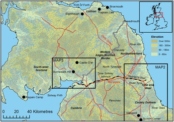
We intend here to re-assess the impact that the decision to build Hadrian's Wall had on the society and economy of the frontier zone in Britain, in the light of newly available archaeological evidence. We will also consider the question of whether there was any kind of conscious social and economic policy accompanying the building of the Wall. In what follows, ‘the frontier zone’ is defined as Britain between the Tees and the Forth (fig. 1). Because so much of the new evidence is the product of development-driven archaeology in north-east England, this paper is inevitably weighted towards the lowland east and has less to say about the west (Cumbria, south-west Scotland), where it must be a research priority to pursue similar questions. In this paper the term ‘conquest’ refers to the military overrunning of the defined frontier zone in the 70s a.d., not the conquest of 43.

SETTING THE SCENE: THE FRONTIER ZONE BEFORE HADRIAN
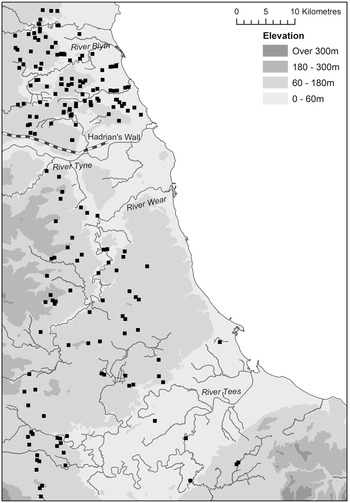
When they invaded the eastern lowland part of the region, the Roman conquerors found a densely settled agrarian landscape, now better documented and understood since the turn of the century, thanks to a stream of discoveries from developer-funded archaeology.Footnote 2 The settlement pattern north of the Tyne was dominated by rectilinear enclosures, which we now know had developed by c. 200 b.c. (fig. 2). Lowland Northumberland, Tyne and Wear and Lothian can be seen to mirror the Iron Age of much of eastern England between Yorkshire and the Wash. These heavily enclosed rectilinears occur at intervals as close as 1 km. They were merely the nuclei of extensive and complex farming settlements, constituting the upper range of an evident social hierarchy, with contemporary subordinate settlements represented by unenclosed or more lightly enclosed roundhouse settlements, previously archaeologically invisible.Footnote 3 The upper strata of society seem to have consisted of a numerous and widespread nobility, the most successful members of a ‘competitive social formation’.Footnote 4 With the exception of Stanwick (North Yorks), just south of our zone and seat of the client kingdom that functioned as the diplomatic gateway into this area for the Romans in pre-conquest times, there is no evidence for centres of higher social authority (‘oppida’). At Traprain Law (Lothian), the hillfort often seen as the seat of a pro-Roman polity does not seem to have seen much activity in the immediately pre-Roman Iron Age.Footnote 5
Distribution of known enclosure sites of the late pre-Roman Iron Age in north-east England. (Sources: Haselgrove 1982, fig. 9; Hodgson et al. Reference Hodgson, McKelvey and Muncaster2012, fig. 99; Tyne & Wear and Northumberland HERs).

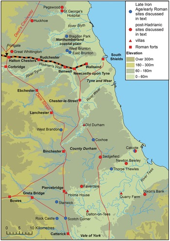
Because of the pattern of modern development, this relatively complete picture cannot be extended south of the Tyne into County Durham, but here there are similar rectilinear enclosures (West Brandon, near Durham, and Coxhoe, south of the Wear, being the excavated examples: see fig. 3 for these sites and others in north-east England)Footnote 6 and there is no reason to think that the Tyne formed a cultural or political boundary between groupings. This is equally likely to have lain further south, perhaps on the River Wear. Hadrian's Wall was not located in relation to any known pre-existing cultural, ethnic, political boundary, and arguably simply placed where it was because of the narrowness of the Tyne–Solway isthmus.Footnote 7
MAP 2: North-east England inset. Squares: Roman forts. Triangles: villas. Blue circles: Late Iron Age/early Roman sites discussed in text. Red circles: post-Hadrianic sites discussed in text.

South of the Wear, and particularly in the environs of Stanwick, the oppidum widely seen as the seat of the client polity known to the Romans as the ‘Brigantes’, a different dynamic is evident. Here it has been suggested that even in the late Iron Age, rectilinear enclosures were being abandoned in favour of open and aggregated settlements.Footnote 8 Neither West Brandon nor Coxhoe showed any sign of having been occupied into the Roman period, while the rectilinear at Rock Castle, near Stanwick, was abandoned before or at the time of the conquest.Footnote 9 Here in the generation after the invasion of a.d. 71 some sites see remarkable development. Only 5 km from Stanwick, on the south bank of the Tees, a well-known villa site at Holme House has pre-Flavian imports and South Gaulish samian, the latter indicating intensive activity by the Trajanic period at latest. Whether this means that the villa is pre-Hadrianic is uncertain, but possible.Footnote 10 Given the proximity to the recently abandoned Roman-connected power centre at Stanwick, a parallel such as the Ditches (Glos.), with its precociously early villa close to the oppidum of Bagendon,Footnote 11 comes to mind, and perhaps makes the installation at Holme House of some pro-Roman local notable most likely. Faverdale, a recently discovered site 5 km to the north-east, and the farm at Thorpe Thewles, north-west of Stockton, both have South Gaulish samian in a quantity unusual for the majority of indigenous sites further north in the region. While Stanwick itself was abandoned at the conquest of 71, there seems to have remained in the agriculturally rich Tees valley a legacy of the client kingdom in the form of a distribution of settlements, some of high status, which had access to Roman supply networks.Footnote 12
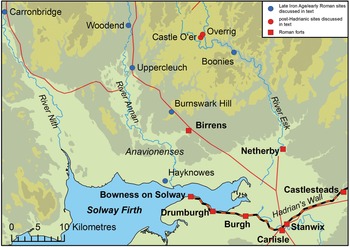
Lowland south-west Scotland (fig. 4) was also densely settled in the late Iron Age, with a distribution of rectilinear enclosed settlements indicating some similarity with the east side.Footnote 13 These rectilinears primarily occupy the better agricultural land in the river valleys, specifically the River Annan and the River Nith, and the coastal plain on the north side of the Solway Firth.Footnote 14
MAP 3: South-west Scotland inset. Squares: Roman forts. Blue circles: Late Iron Age/early Roman sites discussed in text. Red circles: post-Hadrianic sites discussed in text.

Unfortunately the picture remains wholly unclear in north-west England and in the remoter upland areas of south-west Scotland, the Pennines and Cheviots (again because of a lower incidence of developer-funded archaeology). Visible remains in upland areas and sites known from the air in lowland areas (the numbers much enhanced by Historic England's National Mapping Programme) point to a considerable late Iron Age population, probably with a greater pastoral element in its economy.Footnote 15 However, most sites remain undated.
In parts of the frontier zone hillforts are a numerous class of monument, originating in the centuries before 200 b.c., their earthworks and walls often ruined and sometimes overlain by more lightly enclosed or open settlements by the time of the Roman conquest.Footnote 16
In the lowland north-east (Tees valley, Durham) spelt wheat was the predominant cultivated cereal, and it is now clear that this regime did not stop at the Tyne, as once thought, but extended north across the Northumberland coastal plain. However, in a broad sense the frontier zone straddled an area of economic marginality, increasing toward the north: evidence to date from Lothian suggests the cultivation of the poorer emmer wheat predominated there.Footnote 17
The Roman army invaded and garrisoned the entire region in the 70s of the first century en route to the invasion of Scotland and the complete conquest of the island. Troop withdrawals necessitated by wars on the Continental frontiers from the 80s onward frustrated this ambition, and by the later years of the emperor Trajan, from about 105, little was held north of the Tyne–Solway isthmus (along which Hadrian's Wall would later be built), which was more intensively garrisoned, and the ‘Stanegate’ road along it provided with small forts and watchtowers. These have never been found in the eastern 30 miles of the isthmus. The explanation may be that a line of outposts, running along the road known as the Devil's Causeway to Tweedmouth, still enclosed the fertile Northumberland coastal plain north of the Tyne (and possibly a pro-Roman population) in this period, and indeed formed the eastern part of the Trajanic frontier.Footnote 18
Even with dispositions withdrawn to this line, the frontier zone north of the Tees was held by at least 30 forts, which accommodated perhaps 20,000 soldiers (not including any legionaries or detachments from further south temporarily based in the frontier zone).Footnote 19 We should at least double this figure to allow for veterans, camp followers, traders, soldiers’ families and slaves – an immigrant Roman population of 40,000–50,000 is not an unreasonable estimate. Estimates for the indigenous late Iron Age population of the 675 sq. km Northumberland coastal plain between the Tyne and the Aln (that is, to a line 50 km north of the Tyne) suggest that 13,500 would be a plausible middle-range figure.Footnote 20 Perhaps ten times this – some 6,750 sq. km – of the part of the frontier zone under direct military occupation at this time was lowland terrain capable of supporting an agrarian population, with, therefore, a middle-range indigenous population estimate of 135,000. To test this estimate, Britain (England, Scotland and Wales) as a whole has an area of some 243,000 sq. km. Much of this (over half) is sparsely populated upland; if we take 100,000 sq. km as an estimate of the area subject to agricultural exploitation in the Iron Age, multiplied upwards our estimate of 13,500 in a 675 sq. km lowland area would give a convincing sounding total population of two million.Footnote 21
If 135,000 is a reasonable indigenous population count, that means that in the Trajanic period the Roman army and immigrants constituted between 22 and 30 per cent of the total population in the militarily occupied part of the frontier zone. Even if we have underestimated the indigenous population and say that only one in five (20 per cent) was a Roman immigrant, this reveals the scale of the imposition the occupation placed on the local population and immediately underlines the improbability of the subsistence-level family farms of the immediate locality having been able to make anything more than a minor contribution to feeding the Roman population, at least in the decades immediately following conquest. The immigrant Roman population could not have subsisted without food imported over a considerable distance.Footnote 22
For its pottery supplies the army drew on a combination of imported wares (amphorae, samian, other fine wares, some mortaria), these all most likely travelling with the grain and other bulk products imported from outside the region, and locally produced coarse wares and mortaria, often specially made for individual forts or very limited areas, by immigrant- or soldier-potters.Footnote 23 This is the period illuminated by the Vindolanda writing tablets, found at a fort on the pre-Hadrianic Stanegate. These supply remarkable detail about certain supply arrangements and transactions,Footnote 24 but have infuriatingly little information about the immediately local population. One describes, but does not specify the source of, a very large amount of grain collected for transport to Vindolanda, but the agent organising this was sourcing other materials at Catterick (80 km south), so the consignment may have come from there, perhaps a gathering centre for cereals obtained in the Vale of York and further south.Footnote 25
On the other hand, the immigrant military community must have consumed locally obtained perishables, and it is inconceivable that the more immediately local indigenous population was not in some way taxed or subject to requisition. Tax cannot have been collected in cash, and must have been in kind: perishable foodstuffs, cattle, hides, land, or even people, would be possibilities, as Tacitus (Ann. 4.72) illustrates. Shortly before 105 an equestrian officer, Haterius Nepos, conducted a census among the Anavionenses of (probably) Annandale in south-west Scotland; it has been convincingly argued that they were being forced to supply military recruits.Footnote 26 Taxation in kind would be easier where there were pre-existing social authorities through which it could be co-ordinated. Presumably the widespread upper level of the ‘competitive social formation’, the leading families, played a role in channelling Roman demands. They must have been used to dealing with authority projected from the Stanwick centre in the pre-conquest period. If the personnel at Stanwick co-operated at the time of conquest, Rome would have been able to plug straight into this ready-made network of communication with elites throughout the region. However, the ‘tribes’ listed by Ptolemy should not be taken as evidence for centralised political structures. The known or suspected civitates centred on Aldborough, Carlisle and Corbridge are likely to be entirely artificial Roman creations, the latter two potentially of much later date. A Vindolanda tablet of c. 100 attesting a centurio regionarius based at Carlisle suggests that direct military rule persisted in at least the western part of the region 30 years after the original conquest.Footnote 27
The point to emphasise is that, however onerous the imposition of Roman rule on the indigenous population, the military invasion and occupation did not immediately lead to widespread depopulation or site abandonment. This is certainly the case north of the Wall, where indigenous sites commonly produce finds such as glass bangles and certain types of pottery which can only have been acquired after the conquest of the 70s.Footnote 28 There is also evidence that in the lower Tyne Valley the traditional agriculture of the region was still being practised on the eve of the construction of Hadrian's Wall, around a.d. 120, for active Iron Age cultivation regimes have been found and excavated beneath the construction levels of the Wall and its forts.Footnote 29 This should not surprise us: the general pattern in lowland Britain, the Midlands and Yorkshire, is for a good number of pre-Roman sites to persist under military occupation and in fact for at least some to go on to expand and develop under Roman rule.Footnote 30 Between the Tyne and the Tees, there is a less consistent picture – fewer sites have been excavated and published, but what is evident is the precocious late first-century development and unusually privileged connections of a group of sites in the Tees valley.
How, then, was the subject population of the frontier zone affected by the building, in its midst, of the most substantial of Roman frontier walls? We leave aside here the fact that the Wall was probably planned and built against a background of serious warfare. About a war that certainly occurred, very possibly at the time of Hadrian's arrival in the province, we have little historical information, but there is a literary indication of the scale of Roman casualties, and major reinforcements from outside the province were needed.Footnote 31 These events might have involved or profoundly affected the immediate locals,Footnote 32 but it ought to be remembered that whatever forces of ‘Britons’ the Romans were fighting may have emanated from the far north, beyond the frontier zone we are considering; conversely there may have been internal revolt in the area to the south largely evacuated by the military.
What about longer-term consequences of the building of the Wall for the local people and their economy? Archaeologists have, until recently, been puzzled by an apparent failure of social development in the 50 km south of the Wall, particularly in the fertile Tees valley/Durham area, where there seemed to be few or no signs of the emergence of new styles of building or architecture or site planning that might indicate an indigenous elite profiting from a developing provincial economy. Such changes, while often very gradual and taking an infinite variety of forms, were usual in the province further south.Footnote 33 A widely accepted explanation has been that the permanent presence of the Roman army on the northern frontier hindered economic development: ‘such an army of occupation usurped native control and destroyed the very process that Rome relied upon – government by a pro-Roman elite’.Footnote 34 For C.R. Whittaker, ‘The almost total absence of villas and cities in the northern military zone and the sparseness of Roman coins and artefacts on native sites’ suggested that ‘the Romans were creaming off the surplus produce and stultifying the growth of the local aristocracy’.Footnote 35
Conversely it appeared, in the view of their pioneer investigator, George Jobey, that the ‘native’ sites north of the Wall developed and prospered in a pax Romana – he saw the Roman period as the period of maximum growth of the rectilinear enclosure sites that he investigated in Northumberland.Footnote 36 Thus, it has been thought, two very separate worlds continued to run in parallel, meeting and integrating in the civil settlements attached to the Roman forts – and, it is often assumed, the local population must have provided the Roman army with grain, meat and leather, whether purchased or taken as tribute.Footnote 37
The idea that life for the indigenous farmers went on much as before fitted comfortably with the dominant view of Hadrian's Wall (which came into particular prominence in the era of Jobey's exploration of what he always termed the ‘Romano-British’ settlements) as a barrier to regulate, rather than to prevent, the movement of people; a bureaucratic border rather than a defence, meant to facilitate the normal economic relationships of a divided people. This picture has begun to change, and social transformations both north and south of the Wall, previously unimagined, have been detected.
WHAT CHANGED WHEN THE WALL WAS BUILT?
SOUTH OF THE WALL
There is now reason to believe that the rarity of Roman forms of rural and urban settlement between the Tees and Hadrian's Wall is not all that it seemed; such developments are now apparent and, moreover, these appear at a remarkably consistent early to mid second-century chronological horizon.
The Tees valley area
Besides the long-known Holme House villa, there is increasing evidence for a distribution of villas in the Tees lowlands, with one partly excavated example at Ingleby Barwick, near Stockton, now published in detail.Footnote 38 Here the development of the villa began in the mid second century, and the complex was in use throughout the remainder of the Roman period. The main house, of wing-corridor type, was not excavated, so may not represent the earliest version of the principal residence on the site. A further villa has been documented at Dalton-on-Tees, again of second-century origin. Both of these villas seem to have developed on pre-existing Iron Age farms or enclosures.Footnote 39 Roman-period stone buildings have now been found on the north side of the river at Hurworth-on-Tees, only 2.5 km from Dalton.Footnote 40 Besides the villa sites discussed there are other mid to late Roman-period settlements and field systems without Iron Age antecedents, indicating new social configurations in the area shielded by Hadrian's Wall.Footnote 41
A site at Faverdale, near Darlington, investigated in 2003–4, saw the rapid development by the Hadrianic period of an enclosure complex making use of Roman pottery, metalwork and building technologies (fig. 5).Footnote 42 Mortaria stamped by ANAVS, a well-known producer for the northern military market in the first half of the second century, were manufactured at Faverdale, possibly from as early as the decade 110–120.Footnote 43 There was also evidence for smithing, bronze working and textile manufacture.Footnote 44 Whenever established, this production site clearly flourished immediately following the building of Hadrian's Wall.Footnote 45
The enclosure complex at Faverdale. (From Proctor 2012, fig. 10. Reproduced by kind permission of Jennifer Proctor/Pre-Construct Archaeology).

It has been speculated that there may be an undiscovered villa at Faverdale. No residential building was found in the largest enclosure, but the excavators concluded that one probably existed, all trace now removed by ploughing. That there was some high-status residence here is made probable by a notable characteristic of both the Ingleby Barwick villa and Faverdale: the presence of a small, free-standing, hypocausted building – a single-room structure, termed ‘caldarium’ at Ingleby Barwick, and two-roomed and described as a ‘heated building’ at Faverdale. These have been interpreted by the excavators as a local adaptation or interpretation of baths. They are obviously modest structures without the conventional sequence of cold and heated rooms usual in even the smallest of Roman baths, but the attribution as baths, as opposed to some utilitarian function such as corn-drying, is supported by the occurrence of painted wall-plaster in the Faverdale example, and in both cases there may have been appended rooms built in timber which have not survived. Small detached baths are known in the region to the south, such as the villas at Langton (North Yorks) and Dalton Parlours (West Yorks), but these are later Roman. What is remarkable about the County Durham/Tees examples is their second-century date: the Faverdale hypocaust was out of use by the end of the century;Footnote 46 that at Ingleby Barwick associated by its excavators with the mid second-century emergence of the villa complex, although there is a suggestion that it might pre-date the known principal residence.Footnote 47
North of the Tees valley area
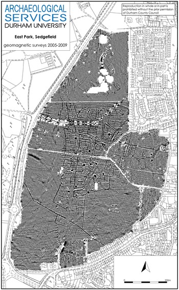
A previously unsuspected settlement was discovered at East Park, Sedgefield, in 2002 and geophysically surveyed and investigated in 2005–8 (fig. 6).Footnote 48 The settlement lies 35 km south of the Wall, on the Roman road known locally as Cade's Road. A system of ditched and fenced enclosures extends over 24 ha, the largest measuring 50 by 50 m. To the west they simply line the road, but to the east they are divided by a more complicated pattern of side roads and back lanes. Sample excavation has shown one enclosure to contain rectilinear timber buildings, a pottery kiln and evidence of stock-holding and industrial activities, and a central open area east of the road to contain an aisled timber building measuring 12 by 9 m, thought possibly to have a public or religious function. The pottery from the single excavated kiln is probably later second or early third century. The pottery from the site as a whole is unpublished and any conclusion about the period of use of the settlement must be provisional. According to one interim statement, ‘Occupation began in the second quarter of the second century a.d., continued through the third, and then declined rapidly in the fourth’.Footnote 49 The agglomeration of enclosures constituting the main settlement is strikingly similar to that which emerged at Faverdale and which is known to have flourished from the Hadrianic period. The site has been described a ‘ladder-style’ settlement, but in fact resembles what outside this region might be termed a nucleated or roadside settlement, and has some similarity to Bainesse, on the outskirts of Catterick, only 35 km south.Footnote 50 In the interim reports there is no indication of buildings and pottery in the indigenous tradition.
The roadside settlement at East Park, Sedgefield. (Reproduced by kind permission of Durham County Council and Durham University).

The distribution of sites with ‘villa’ characteristics in the Tees valley tends to rehabilitate the remains long known at Old Durham, 22 km north of these and only 22 km south of Hadrian's Wall, as belonging to a villa.Footnote 51 Here a bath building was identified as civilian by its excavator, Ian Richmond, who identified the site as a ‘Roman-British farmstead’, postulated a main residence close by, and showed that the pottery suggested a site in existence by the mid second century. He presciently said: ‘That this area has hitherto yielded no Roman domestic buildings is not surprising. It has been heavily and early cultivated. Many structures, so slight when compared with the massive and extensive remains of Roman forts, may have been totally removed by the plough … There is thus hope for further discoveries in the county’.Footnote 52 Although more extensive than those at Faverdale and Ingleby Barwick, the baths at Old Durham were also of unusual and attenuated form, lacking the usual sequence of frigidarium–tepidarium–caldarium.
How should we interpret the emergence in the second century – at a date which is strikingly earlier than that at which villas tend to develop further south, in Yorkshire – of new site types in the eastern area immediately south of Hadrian's new wall? And can we see a deliberate Roman policy at work here? It is difficult to determine whether they are the initiatives of indigenous communities responding on their own terms to an imposed imperial system (very much the dominant model),Footnote 53 or the creations of Roman immigrants – traders or military camp-followers, say – controlling and exploiting indigenous people. Nor is it likely that the answer to the question will be the same for every second-century development south of the Wall.
The balance of interpretation in the Faverdale excavation report is strongly towards indigenous agency, but also invokes Roman veteran settlement as a possible factor in the development of that remarkable site.Footnote 54 Alongside imported Roman pottery ‘generated by social activities that had more in common with those exhibited in Roman urban contexts than northern rural situations’,Footnote 55 and Roman pottery manufactured on site for the military market, local traditional ware continued to be used. Indeed, it dominated the assemblage in the second-century settlement and, in a way unparalleled in the region, some of this pottery imitated Roman styles. Roman building technologies (the ‘bath’ building, roofing tiles etc.) were associated with the main enclosure, but roundhouses were found in the subsidiary enclosures, where typically Iron Age ritual deposition of querns took place. In the report this is ‘evidence for the selection, rejection and hybridization of certain aspects of Roman material culture by the Faverdale community’ – thus an indigenous response to the Roman presence, ‘in which the inhabitants of Faverdale were apparently active agents’.Footnote 56
Of course, all this evidence could be read another way, as indicating less benign effects of Roman imperialism: immigrant entrepreneurs might have established a production site at Faverdale, using an enslaved labour force (possibly with the connivance of an indigenous elite) accommodated at the site in the enclosures subsidiary to the principal one. The continued production and use of local handmade wares, even though imported wares reached the site in considerable quantities, might indicate segregation of two distinct groups on the site. The presence of a workshop of ANAVS does not sit easily with the idea of an autonomous indigenous initiative; the mortarium maker is surely more likely to have travelled or sent agents into the region in the wake of the army to set up his workshop. Kay Hartley makes the point that there is no known example of a workshop where only mortaria were produced.Footnote 57 Other coarse wares were surely made at Faverdale. The imitation of Roman styles in local hand-made wares also follows a tradition well known in southern Britain (e.g. early BB1, Gabbroic wares) where the need was to supply a military market. A foodway such as a high level of pork consumption in the main enclosure 7 is uncharacteristic of Iron Age tradition and may indicate an immigrant population,Footnote 58 as might the literacy implied by a graffito of IANUARIVS on a samian vessel of 120–155.Footnote 59 The form of the principal enclosure has been seen as in the native tradition – the argument also applied to Holme House and Dalton-on-Tees, suggesting ‘that their owners were local Britons’,Footnote 60 but this settlement form has also been seen as being superseded in the Tees valley in the first century b.c., nor does the agglomeration of enclosures at Faverdale resemble any immediately local native tradition.
Ultimate resolution of this issue is impossible on present evidence. On balance, the association with the environs of Stanwick and the late first-century imports suggest local indigenous inhabitants for Faverdale,Footnote 61 Thorpe Thewles, Holme House and possibly other villas in the vicinity in the years immediately after the conquest. On the other hand, the apparent role of Faverdale as a main production centre for ANAVS, one of the most prolific mortarium potters in the north, strongly suggests that by the early second century this site had become a Roman industrial-commercial complex run by outsiders.
Further from Stanwick, there is little question that the villa at Quarry Farm, Ingleby Barwick, succeeded a pre-Roman Iron Age farm, but that of course does not prove direct continuity of Iron Age farmer into villa owner. The excavation report balanced a number of possibilities when considering who might have commissioned the villa: a military veteran; a local elite member who was also a military veteran, with money and taste acquired independently and elsewhere; a leading local farmer who had accrued capital through supplying the Roman army; a serving or retired official or freedman.Footnote 62 The answer to the question is, of course, unknowable, but the lack of first-century imports differentiates the site from those just discussed.Footnote 63
Further north, only 32 km from Hadrian's Wall, an important piece of evidence has emerged: a diploma (certificate of Roman citizenship issued on discharge) issued in 150 to a British veteran of the German fleet found in the area of (not at) the fort of Lanchester on Dere Street. So, a Briton returned to the island after 26 years of service overseas. There is no guarantee that the princely-sounding Velvotigernus, son of Magiotigernus (‘great master’), was local to the northeast, but Tomlin and Pearce see northern or ‘Brigantian’ affinities in the ‘Velvo’ element of the name.Footnote 64 The obvious inference is that Velvotigernus settled in the vicinity of Lanchester (20 km south of the Wall) – but in what sort of settlement? We can rule out a connection with Lanchester fort itself, which was not founded until c. 160. The remains at Old Durham, only 18 km east, suggest that it is entirely possible that other undiscovered villa-type settlements exist this far north. Indeed, David Mason has recently drawn attention to a mid nineteenth-century discovery at Sately, only 6 km from Lanchester and very close to the diploma findspot. Here a Roman masonry building, associated with coins of the period 120–160, seems likely to have been part of a small villa complex.Footnote 65
This raises the possibility of a complicated picture whereby there is early post-conquest farming and some precocious villa development by a Romanophile group in the Tees valley area, which by the Trajanic–Hadrianic period has become an active collaboration with, or has even been partly taken over by, traders and suppliers to the military. Nearer to the Wall, the second century – perhaps specifically the building of the Wall – might have been accompanied by official settlement of veterans, as the Velvotigernus diploma and early villa developments hint, and the foundation of immigrant communities, as Sedgefield might suggest. Whatever the agencies involved, in all areas this comes across archaeologically as an imposition of new site types on the landscape broadly contemporary with the Wall-building project.
This is not yet proof of a conscious policy to colonise and develop land in the immediate hinterland of the Wall, but some element of ‘official’ settlement might be expected in the light of contemporary developments on the continental frontiers. Michel Reddé has traced the development from long-distance supply of the German frontier army predominating during the conquest period towards supply from more local settlements, as for example in the Neckar Valley, where the appearance of farmsteads seems to coincide with the settlement of troops in the early second century. These developments are said to have taken place in sparsely populated areas and were not the initiative of an indigenous population, rather the work of incoming frontiersmen.Footnote 66 A contemporary parallel can be seen in Raetia, where the frontier forts beyond the Danube, along the arc that would later be followed by the limes palisade, enclosed an area of good agricultural land that seems to have been densely settled with villas in the early-second century, crowding right up to the fortified line. C. Sebastian Sommer deduces an immigrant population (possibly in this case involving indigenous elements transplanted from south of the Danube), settled here as an act of policy, for the purpose of military supply.Footnote 67 It is against this exactly contemporary continental background that the developments in the immediate eastern hinterland of Hadrian's Wall might be considered, although in the case of the Stanwick–Tees area some of the development in Britain is pre-Hadrianic and sprung out of the local Iron Age background in a way at present unattested on the German frontier.
In the long run, the rapid second-century development of the region immediately behind Hadrian's Wall faded. By the third century, military pottery supply was dominated by industries further south in Britain, their locations correlating, it has been argued, with the most developed agricultural lands of the central part of Britain, from which supplies were brought to the northern frontier over a long distance. This development was perhaps originally stimulated by the needs and opportunities presented by the Antonine advance into Scotland.Footnote 68 Later Roman occupation was not intensive at the production sites at Sedgefield and Faverdale (in contrast to an extensive late Roman rural settlement recently found just near the latter at Symmetry Park).Footnote 69 The part of the second-century burst of activity in the Durham/Tees area with the strongest legacy was in the Tees valley, where the villa sites prospered in the late Roman period, the probable navigability of the river aiding the export of agricultural products, and where further villas surely await discovery.Footnote 70
NORTH OF THE WALL
In the zone extending for 40 km (25 miles) north of the Wall, the pre-Hadrianic landscape was transformed in the course of the second century a.d., indicating an equally significant but very different societal change from that to the south. This realisation stems from development-driven archaeological work over the last 20 years on the indigenous settlements of the Northumberland coastal plain. The fact that much larger areas are now stripped and examined than was ever the case in the 1960s/70s and, crucially, the financial resources made available through developer-funding, mean that it is now possible to date the period of occupation of sites which are poor in artefacts by means of extensive programmes of radiocarbon dating.
Dated and published sites now include an agglomerated late Iron Age site at Pegswood (near Morpeth, 22 km north of the Wall),Footnote 71 and heavily enclosed rectilinear enclosure sites at East Brunton, West Brunton (both in Newcastle Great Park), 6 km north of the Wall, and at Blagdon Park (12 km north).Footnote 72 For the Brunton and Blagdon Park sites, over 60 radiocarbon dates allow the chronology of the settlements to be much more closely understood than has been possible before in this area. The scientific dates have been analysed and combined in Bayesian models by Derek Hamilton.Footnote 73
Besides showing that these sites had reached their most developed form around 200 b.c., the radiocarbon evidence shows that, rather than co-existing with Hadrian's Wall, they were abandoned by the second century a.d. At East Brunton, West Brunton and Blagdon Park 2, abandonment was total; at Pegswood, the settlement that had evolved over centuries was abandoned and replaced by a much smaller non-settlement enclosure, possibly a stock-corral.
The picture in the zone immediately north of the Wall on the west side is not as clear, as we lack developer-funded radiocarbon data. Of four excavated rectilinear enclosures in south-west Scotland, namely Hayknowes (immediately north of the Wall on the far side of Solway, Annan),Footnote 74 Carronbridge (40 km north of the Wall, Nithsdale, Dumfries and Galloway) enclosures A and C,Footnote 75 and Rispain Camp (60 km west of the Wall system, Dumfries and Galloway),Footnote 76 none has produced strong evidence of occupation beyond the second century a.d. Of non-rectilinear settlements, Boonies (30 km north of the Wall, Annandale, Dumfries and Galloway) was probably out of use by the second century a.d.,Footnote 77 and there is no strong evidence that another curvilinear enclosure, Upper Cleuch in Annandale (26 km north), went on for very long in the Roman period.Footnote 78 There is thus an impression of widespread abandonment of settlements in south-west Scotland in the course of the second century.Footnote 79 Abandonment cannot be tied so chronologically closely to the imposition of Hadrian's Wall (or any other event) as in the case of sites immediately north of the Wall in north-east England. However, the same general pattern holds true, that settlements do not appear to have been abandoned at the time of the first (Flavian) Roman conquest, but to have subsisted until some ill-defined point in the mid-Roman period.
At the ruined hillfort of Burnswark, which dominates the skyline north of the Solway and is visible from Hadrian's Wall, there was evidently major re-occupation around the time the Wall was built: the datable Roman finds from the hilltop are predominantly second-century rather than Flavian.Footnote 80 The hillfort was closely accompanied by a Hadrianic Roman outpost fort (Birrens). The relative absence of Flavian material from Burnswark suggests that the occupation was a second-century development, perhaps part of a Hadrianic policy to establish a friendly authority just north of the Wall here (in an area abandoned by the Roman military in the preceding Trajanic period). The hillfort was later invested with Roman camps and bombarded.Footnote 81 Whatever the reason for this, occupation of the site clearly came to an end by the Antonine period at latest.
The radiocarbon evidence from the Northumberland coastal plain, although obviously a preliminary sample, casts doubt on the assumption that the many Iron Age settlements known from air photography immediately north of the Wall were occupied contemporaneously with the barrier. It has long been recognised that Roman finds from the sites investigated by Jobey were, with very few exceptions, not later than mid second century in date. Jobey himself was reluctant to concede that these sites were not occupied in the later Roman period, arguing that Roman material was only available in smaller quantities after a.d. 200.Footnote 82 But it is the near absence of later second- and earlier third-century pottery, of a period when the Wall-forts and their attached settlements (vici) were vibrant, that is most telling. One exception in Northumberland, the site at Huckhoe, 16 km (10 miles) north of the Wall, has produced third- and possibly fourth-century pottery.Footnote 83 This shows that the absence of similar pottery at the other sites is significant. If the generality of pre-Hadrianic settlements had continued to be occupied beyond the second century, we would expect at least a few vessels of the type documented at Huckhoe to have reached them. As already said, abandonment did not come with the first contact with the Roman military in this region in the 70s a.d. Traditional life had apparently gone on for half a century or more following the conquest and had been interrupted at some later stage. It seems inescapable that this was somehow linked to the permanent fixture of the Wall on the Tyne–Solway and is a counterpart to the developments on the south side of the Wall that we have already traced.
What happened to the people north of the Wall? There was not entire depopulation: at some of the remoter upland settlements in North Tynedale, second-century samian was found under sequences of timber and stone roundhouses, and there are occasional third- or fourth-century radiocarbon dates from this area.Footnote 84 In south-west Scotland one curvilinear enclosure, Woodend Farm (35 km north of the Wall, in Annandale),Footnote 85 has produced later Roman-period radiocarbon dates, but no later Roman finds – only quernstones and stone tools, illustrating the difficulty of recognising those sites that endured after the second century. Pollen and phosphate evidence indicates that this was a primarily pastoral site. As we shall see, cattle-raising settlements in the remoter valleys of south-west Scotland continued to function. What we are seeing is an impact, felt most suddenly in more populous lowland areas (such as the Northumberland or Solway coastal plains), where a monumental building tradition of earthwork enclosures, and the sequences of substantially founded timber roundhouses that leave such an unmistakeable archaeological signature, came abruptly to a close. Possibly it was the complex networks of social rank and obligation in these well-populated agrarian areas that were most likely to be interfered with by Roman authorities or most prone to collapse in the face of the changes wrought by exclusion beyond the new frontier wall. Here the Wall seemingly brought a long-standing social formation to an end.
Various explanations, not necessarily mutually exclusive, have been discussed.Footnote 86 It is possible that settlements within a defined zone north of the Wall were abandoned as an act of Roman policy – the imposition by imperial authorities of a cleared zone 10 miles wide, say, north of the Wall. This idea of a cleared zone, attested on other frontiers,Footnote 87 once the natural expectation, went out of fashion because of the discovery, especially from the air, of increasing numbers of ‘Romano-British’ settlements close to the Wall and assumed (without dating evidence) to co-exist with it.Footnote 88 The possibility of a cleared zone must be reconsidered now that the radiocarbon dating just discussed points to widespread site abandonment around the time the Wall was built. There is nothing implausible about the displacement or disappearance of a substantial population group: a similarly dramatic rural depopulation in Germania Inferior has recently been discussed.Footnote 89
However, this explanation alone will not suffice, as abandonment or dislocation seems to extend further north than any putative cleared zone, as we have seen at Pegswood (22 km north of the Wall), and much further north, in Lothian, where it is hard to find sites in continuous occupation into the later Roman period, although there is later re-use of settlements, taking different forms, for example sub-rectilinear stone paved buildings.Footnote 90 The centuries-long sequence of occupation at the recently published hillfort at Broxmouth in East Lothian ends in the second century a.d.Footnote 91
Several dynamics may be at work here. Beyond any cleared zone that there may have been, exclusion from the Roman province on the north side of the Wall perhaps fatally weakened the relationships that had allowed the most successful households to draw on social obligations to express their status in substantial earthwork enclosure and roundhouse building. A population whose leading members had treated with the Romans and had perhaps even been protected by the pre-Hadrianic frontier arrangements (the postulated line along the Devil's Causeway) might, with the withdrawal to the Wall, have become vulnerable to attacks from anti-Roman peoples in the upland to north and west. It may even have been the case that elements of the Northumberland coastal plain population were re-settled south of the Wall – re-ordering by enforced migration is an attested policy on other frontiers.Footnote 92
A further complication is that social change is evident much further north, in much of lowland and north-east Scotland, with sites showing a pronounced dip in radiocarbon dates after a high plateau in the first two centuries a.d., and evidence for structural dislocation or abandonment of settlements similar to those found in Northumberland.Footnote 93 This phenomenon finds its counterpart in the emergence of new names applied by the Romans to social groupings, such as the Maeatae and later the Picts.Footnote 94 In one way or another, the permanent fixture of the Roman frontier went on to have a transformative effect on the societies beyond. We have seen the effects in the immediate frontier zone. Further out, an intermediate zone was probably under Roman diplomatic control through the hillfort at Traprain Law, 100 km beyond the Wall, intensively occupied in the Roman period and evidently a new centre of social authority where wealth was accumulated from exchange with, or gifts from, the empire. Beyond lay an outer zone, beyond the Forth, where wealth might accrue variously from Roman diplomatic gifts or from raiding the empire.
The process might have been comparable to the contact between modern colonial powers and traditional competitive social formations in Africa, when more centralised kingdoms emerged through their ability to control resources and meet the demands of European trade for commodities such as slaves.Footnote 95 Iron Age societies in southern Britain had become more politically centralised, with the emergence of ‘royal’ figures, through contact with the Roman world before the conquest of a.d. 43.Footnote 96 It is only to be expected that analogous, though not identical, processes would occur in the unconquered part of the island, once the limit to formal empire was fixed by Hadrian in the a.d. 120s. We do not hear of kings, but the individuals holding social authority probably changed, as the leaders of traditional social networks were replaced by those who could best deal with and profit from the adjacent empire. It is perhaps against such a background that the widespread passing of the traditional Iron Age settlement pattern extending far north of the Wall is to be understood.
Owing to the imprecision of archaeological dating, it is impossible to establish a correlation between any of the changes discussed and the brief move to the Antonine Wall c. 142–c. 160. There is no clear evidence for re-occupation of abandoned sites between the two walls in this period, though that might have left no archaeological trace, and cannot be excluded. Most of the excavated sites within the putative cleared zone north of Newcastle have produced very little or no Roman material, which makes it look as if they were abandoned for good in the Hadrianic period. Abandonment of sites north of the putative cleared zone, and in south-west Scotland, may have been more gradual and could conceivably have occurred after the abandonment of the Antonine Wall, following which the frontier arrangements on the Tyne–Solway truly hardened into a final form.
POST-HADRIANIC SITES NORTH OF THE WALL
While we see social collapse and the abandonment of the distinctively dense form of late-Iron Age settlement north of the Wall in the east, the landscape was not left wholly depopulated or disused. Pollen diagrams for the area immediately north of the Wall (though there is none from the Northumberland coastal plain itself) do not indicate woodland regeneration until after the Roman period.Footnote 97 In south-west Scotland, too, there is no significant regeneration in the pollen record for the period, indicating that the land was still being utilised.Footnote 98 The issue is that whatever kinds of settlements succeeded the conspicuous late Iron Age enclosures, they were almost certainly fewer and are less archaeologically visible. We have no way of knowing whether the people now using the land were remnants of the former population or newcomers. On the eastern coastal plain, two recently discovered sites (again thanks to developer-funded archaeology) stand as rare indicators of what succeeded the former agrarian pattern in the area extending 50 km or so north of Hadrian's Wall.
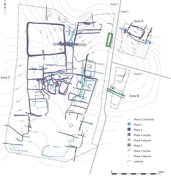
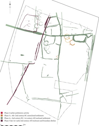
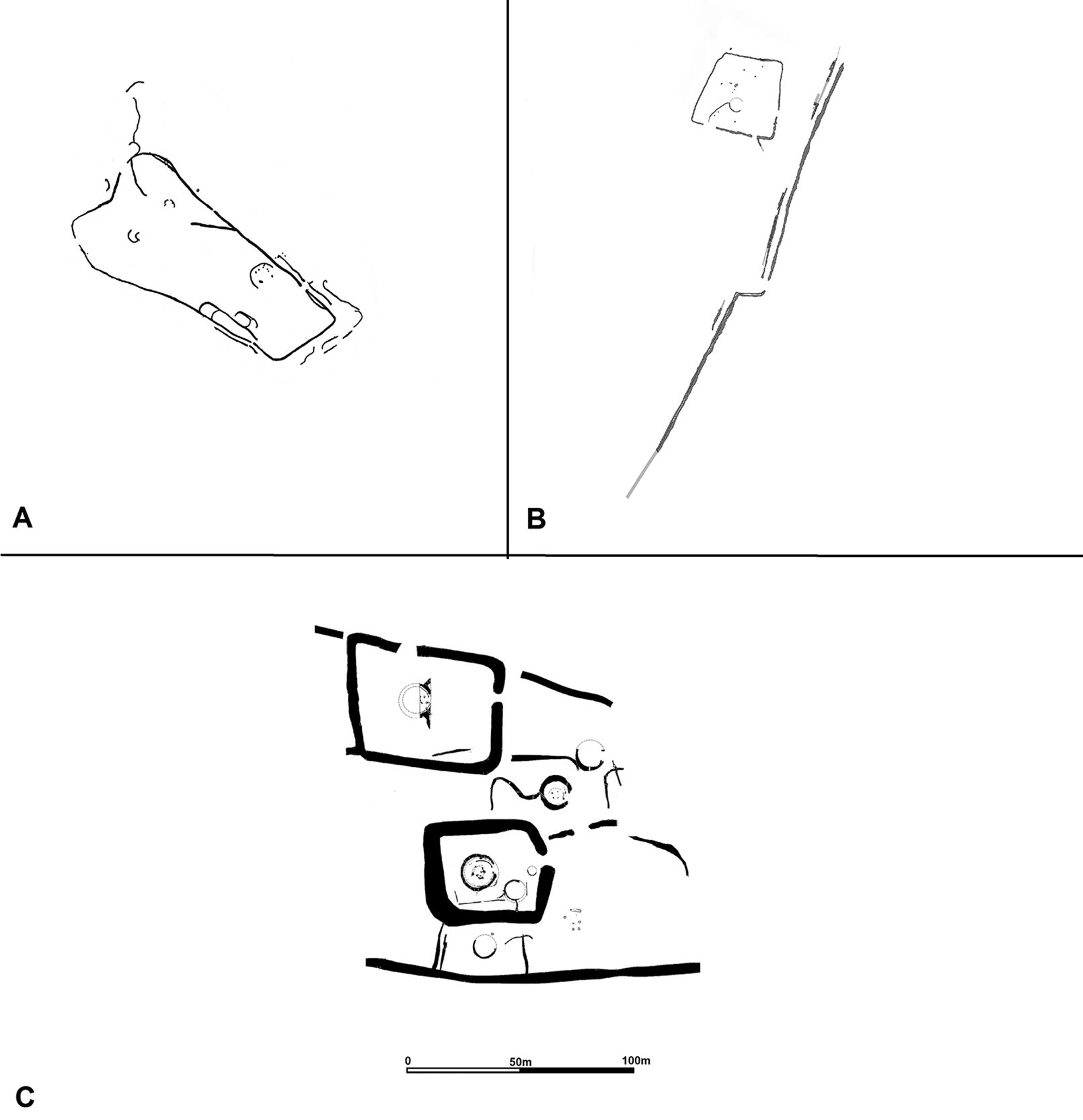
At Pegswood Moor, Northumberland (fig. 7), a complex of Iron Age enclosures and houses was completely abandoned. Stratified finds show that it was superseded after the late first or earlier second century by a stock enclosure (of palisade construction quite different from the earthwork enclosures of the late Iron Age), and a fenced droveway apparently for the movement and selection of animals (figs 7; 8B).Footnote 99 Only 1.5 km away, at St George's Hospital, Morpeth, a small-ditched enclosure incorporated droveways indicating its use for stock collection (fig. 8A). A series of four radiocarbon dates indicates its use in the second to fourth centuries a.d.Footnote 100 It is important to note that, although an enclosure, this site is different in character from those of the pre-Hadrian's Wall period, its ditches being insubstantial and lacking the scale of the massively enclosed late Iron Age sites which had evidently been constructed to express prestige and social ranking (fig. 8).
The Roman period enclosure and droveway at Pegswood Moor. Phase 5 (purple) represents the Roman-period site; the more extensive underlying Phase 4 (green) was abandoned by the second century a.d. (From Proctor Reference Proctor2009, fig. 4. Reproduced by kind permission of Jennifer Proctor/Pre-Construct Archaeology).

The Roman period enclosures and droveway arrangements north of Hadrian's Wall at St George's Hospital, Morpeth (A) (reproduced by kind permission of Archaeological Research Services Ltd) and Pegswood Moor (B). Note the slight nature of the ditches when compared to a typical pre-Roman Iron Age enclosure complex such as West Brunton (C), abandoned when Hadrian's Wall was built.

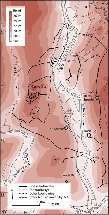
Two sites that have been known about for much longer, Castle O'er and Huckhoe, add to the overall picture of post-Hadrianic society north of the Wall. At Castle O'er, 33 km north of Hadrian's Wall, in Dumfriesshire, an earlier Iron Age hillfort was supplemented by an annexe and an attached network of ditched and banked boundaries laid out over much of the surrounding landscape (fig. 9).Footnote 101 Structural sequence and radiocarbon dating (old dates on bulk samples, so imprecise) suggest a broadly first- to second-century Roman date for this system of land organisation. This was almost certainly to do with the management of livestock collected from surrounding settlements, suggested on morphological grounds to be related to one another and possibly indicative of the tenurial arrangements that ‘fed into’ Castle O'er.Footnote 102 The small local sites – of a scooped, curvilinear enclosed type – are usually undated, but the one excavated example, Boonies, was in use into the second century. The complex of land divisions at Castle O'er also contains the enigmatic enclosure at Over Rig, lying below the hillfort in a secluded bend of the White Esk river. It is of unparalleled form and untypically sited, at the base of a steep slope. The enclosure contained numerous pits and a central large stone-lined platform. Mercer suggested that it may have served as an assembly site, and a small cache of glass banglesFootnote 103 suggests that, whatever its function, it was in use during the Roman period. He further argued, on the basis of the Roman-period date of its development and a meticulous modelling of the livestock requirements of the Roman army, that the later Iron Age settlement at Castle O'er was transformed into a regional centre for the collection of livestock with the intent to supply the Roman authorities.Footnote 104 The Castle O'er complex might conceivably have come into being in connection with the building of the Wall (and if already existing certainly had its floruit then), and was perhaps in some way associated with the client authority proposed at Burnswark. It is unclear for how long into the post-Hadrianic period the complex remained in operation.Footnote 105 The Wall therefore seems to have been accompanied by the development of new centres of social authority in south-west Scotland, at least one of which (Burnswark) was itself swept away by events a generation later.
Livestock management earthworks associated with Castle O'er, Dumfriesshire. (Reproduced by kind permission of Historic Environment Scotland. © Crown Copyright HES).

The settlement at Huckhoe, 16 km north of the Wall in south-east Northumberland, excavated as long ago as 1957, has already been mentioned. Surrounded by successive palisades and a stone wall in the earlier Iron Age, in something like the hillfort tradition, the site was occupied or reoccupied in the Roman period. It contained stone roundhousesFootnote 106 and yielded Roman pottery later in date than that from any other excavated native site in Northumberland – down to at least the third century and probably into the fourth – and in greater quantity than the local indigenous wares. Querns (including imported Roman types) at Huckhoe indicate that there was still some level of agrarian economy, although Jobey wondered whether there was ‘a recession in crop growing and a concentration on pastoral farming in the later Roman period, in view of the virtual absence of quernstones in a late context’.Footnote 107
Huckhoe and the other post-Hadrianic sites with evidence for livestock collection discussed above are all more than 10 miles north of the Wall but within easy droving distance – less than two days for a person walking. Their character indicates concern with the movement and collection of livestock, the new arrangements unlike pre-Roman Iron Age farms. This is on the basis of the site plans: very little animal bone survives on these sites. Despite the post-Hadrianic dating evidence, there is a very low level of Roman material culture.
This can only be a preliminary sample, but together with widespread site abandonment in the same period, it suggests a re-structuring of society. The pre-Roman Iron Age social network that supported the numerous rectilinear enclosures in the lowlands has vanished. Remaining – or replacement – settlement takes less visible forms and is perhaps governed from, or even concentrated at, new centres. Rather than Roman material being widely distributed to many sites in small quantities, as it was in the earlier Roman period, post-Hadrianic material is concentrated at fewer sites. Huckhoe is the only clearly recognised Northumberland settlement with post-Hadrianic pottery in quantity. The new site-types indicate a possible shift of economic emphasis from agriculture to cattle (and horse?) raising and collection of animals destined to be traded to, or requisitioned as a tax by, the Roman imperial authorities.
The key question with these developments is the same as for the area south of the Wall: did they occur under direct Roman supervision and direction, or were they an indigenous response to the changed conditions of the frontier land? We have a possible earlier example of the former: direct Roman interference to gather tax in the form of livestock beyond the military ‘front line’ perhaps occurred at Elginhaugh (near Edinburgh). Here a Roman fort and its annexe were abandoned around a.d. 86 but apparently remodelled as an enclosure, persuasively argued by W.S. Hanson to have been for the holding and selection of livestock being collected as a form of taxation. If this is correct, the tax was levied on a population no longer under direct military occupation but still subject to Rome in the period c. 86–c. 105. In this case we can imagine that the army was directly involved in remodelling the site.Footnote 108
There are no such hints from the tiny sample of ‘livestock’ sites that we have north of, and contemporary with, Hadrian's Wall. While Pegswood and St George's Hospital do not resemble the substantial late Iron Age enclosures of the region, there is nothing to betray the hand of the Roman army and none of the finds that we might expect if there was direct military involvement. It is important to stress just how poor in artefacts these sites are, St George's Hospital and the last phase at Pegswood not even producing the querns or coarse handmade pottery found on most of the ‘Jobey’ Iron Age sites, themselves notable for their scarcity of finds. Without radiocarbon dating no-one would have imagined St George's Hospital to be of the Roman period. On the other hand, post-Hadrianic Pegswood and St Georges’ Hospital might not have been settlement sites at all – if simply collection points for livestock, an absence of domestic items would be expected. The evidence for domestic settlement is concentrated at Huckhoe.
At Huckhoe, some group was involved in exchange with the Roman empire, as we see from the Roman pottery. The composition of the pottery assemblage does not mirror that of the nearby Roman military sites on the Wall, but is curiously similar to that described by Fraser Hunter for Traprain Law: predominance of jars (a ‘native’ characteristic), few mortaria or amphorae, and a notably high incidence of coarse wares, in contrast to the usual pattern on non-Roman sites in north-east Scotland, where there is selection of samian ware over coarse Roman pottery.Footnote 109 On this basis, Hunter concluded that: ‘It seems, rather counter-intuitively, that coarse wares are typical of higher-status Iron Age sites … a similar broad range has been noted at a number of lowland brochs and at Edinburgh Castle’, and suggested that ‘it seems likely that it was the commodities within the coarseware jars [foodstuffs], rather than the jars themselves, which were of interest to the inhabitants of the focal sites’.Footnote 110
We can conclude that the Roman authorities or traders were content to manage their oversight of the area immediately north of the Wall, and their livestock procurement, by dealing with relatively autonomous groups at centres of social authority such as Huckhoe and Castle O'er.Footnote 111 Yet even though a place such as Huckhoe, with its evident close dealings with the Romans, was only 10 miles north of the Wall, there was extremely limited and selective uptake of Roman material culture. This brings to mind certain areas beyond the Continental limes, the Giessener Gruppe immediately beyond the Wetterau limes of Germania Superior, and the Mainfranken settlements beyond the outer limes, where despite obvious contacts and interactions with the Roman empire there is strikingly low uptake of Roman material – as S. von Schnurbein has put it, the limes ‘acted like an iron curtain’.Footnote 112
TRADE THROUGH THE WALL?
It is also possible that the Roman authorities obtained economic products from far north of the Wall, especially cattle for meat and hides, and perhaps horses,Footnote 113 by means of trade rather than taxation or requisition. Sue Stallibrass has shown how, in more recent centuries, cattle were driven over distances of hundreds of miles from the thinly populated areas best for raising them to markets in populated agrarian lowland areas. Her work shows that areas north of the Wall could have been the source of animals driven on the hoof to the concentrations of military and civilian personnel in the Hadrian's Wall military zone.Footnote 114 The argument has received remarkable corroboration from isotope analysis (by Jessica Waterworth) of cattle bones from a third-century context at South Shields, at the eastern end of the Wall, which suggests that the animals had originated in either Cumbria or south-west Scotland.Footnote 115
In the past – and more recently – the numerous milecastle gateways through Hadrian's Wall have been seen as primarily intended to facilitate and control economic movement.Footnote 116 There are powerful arguments against this interpretation,Footnote 117 which is hardly supported by the new evidence that the Wall's presence led to site abandonment rather than promoting the continuation of normal economic movement and exchange. The frontier barrier in Raetia seems to have been largely closed and impermeable with, according to the latest study, the only openings being provided for the convenience of soldiers servicing the works.Footnote 118 Given the devastation the Wall in Britain wrought on local communities, it seems most probable that it was the same there. This is not to say that there was no trade through Hadrian's Wall. The idea that there was widespread trade across Roman frontiers has been called into question, on the basis that frontier lines do seem to have a barrier-like effect on the distribution of coins and pottery,Footnote 119 and, specifically in the case of Traprain Law, on the basis that the arrival of samian ware is said to coincide only with the periods of direct Roman military occupation of the area.Footnote 120 However, Brian Hartley long ago pointed out that there is post-160 samian from Traprain Law as well as other non-Roman sites in Scotland,Footnote 121 and it is surely conceivable that long-distance exchange accompanied diplomatic gift-giving and support – the point being that these contacts were focused on a few major elite centres. This is not the same as trade contact with the trans-frontier population in general.Footnote 122 There was little trickle-down from these centres into the surrounding area, hence the generally ‘barrier-like’ effect of the frontier lines on finds distribution.Footnote 123 Thus, despite trans-frontier contacts, the effect of Hadrianic policy was to create an essentially closed and impermeable frontier and to interact with society beyond only through its elite representatives.
Huckhoe, Castle O'er, and on a much grander and more distant scale, Traprain Law, may be seen as examples of individual foci of power with which Roman traders and authorities dealt, much as they had with the Brigantian centre at Stanwick/Scotch Corner before the conquest of a.d. 71. Trading delegations from such places, especially those of considerable size and from far away, would have been most effectively managed at a limited number of crossings (perhaps arriving periodically at customary times and places), rather than at a multiplicity of openings through the Wall. The same places could have functioned as reception points for animals and other goods obtained from the zone closest to the Wall.
Recent metal-detector discoveries have revealed the possible location of such a place. Around the village of Great Whittington, just a mile and a half north of Milecastle 21, has been found an extraordinary concentration of Iron Age metal objects, Roman coins, brooches and military equipment.Footnote 124 This has been thought to indicate a settlement site, but the finds are untypical of settlements north of the Wall and a geophysical survey found no trace of a built site. A much more attractive suggestion is that this was a frontier trading place or market, or a waiting area where trading delegations camped under military supervision while waiting to be escorted to a market on the Roman side of the Wall.Footnote 125 Significantly, Great Whittington lies close to the convergence of two Roman roads from the North (Dere Street and the Devil's Causeway) which approach the Wall here. The former passed through the Wall via a special gate (‘The Portgate’) which stands outside the normal milecastle series, and just two miles further south was the Roman frontier town at Corbridge, which by the 160s had developed as a marketing and distribution centre for the eastern Wall zone. In medieval times the Roman roads remained important for droving cattle to the famous cattle fair at Stagshaw bank, held just south of the Portgate. The coins from Great Whittington suggest that the activity began in the earliest days of the Wall; such a special place of arrival at the Wall was therefore a Hadrianic institution. There might be others, where major routes are thought to have passed through the Wall: Carlisle has produced evidence for a possible marketing area just north of the presumed gate through the Wall here;Footnote 126 Newcastle is another possibility. On the whole, then, the Wall appears to have been a barrier preventing widespread uptake of Roman material culture or economic development in the area to the north in the way envisaged in the model of Whittaker, but there were mechanisms by which exchange could take place with social authorities north of the Wall.Footnote 127
CONCLUSION
The recent discoveries described indicate that when the Wall was imposed, there followed a wholly different trajectory of social development to either side of the barrier, although this has emerged as a clear picture only on the east side of the Pennines. The social impacts on either side of the Wall were quite different – economic development by some at present unquantifiable combination of indigenous agency and immigrant/veteran settlement in the agricultural area to the south, widespread settlement desertion, population movement and the emergence of new social configurations to the north.
This picture of an essentially closed frontier separating quite different forms of social development is notably different from the model of economically homogeneous frontier zones, argued for by Whittaker, which has been highly influential since its publication in English in 1994, enlarging the original French version.Footnote 128 Whittaker argued that Roman frontier lines were drawn across zones of transition where there was no clear ecological, cultural or economic division, which, as we have seen, is true in the case of Hadrian's Wall. But he went on to argue that within these zones there was a continuation of the economic exchanges that preceded the political frontier, and that the purpose of frontier walls was to control these pre-existing economic movements and so ‘to maximise the profits of natural exchange, not to exclude them’.Footnote 129 In his view, the rural population might not see much difference, since those that benefited were the elites within the province, and trans-frontier elites in the ‘Vorlimes’ at centres like Traprain Law, while ‘the rural population on either side of the frontier zones was apparently little affected by Roman culture’.Footnote 130 By ‘being little affected by Roman culture’, Whittaker meant that Roman material culture did not trickle down to their sites. But we have seen that, for the people immediately north of the Wall, its imposition had a much graver impact than that, leading to the disappearance of a millennium-old settlement pattern, while to the south of the Wall there was a much greater general uptake of Roman material, whatever the social mechanisms driving this.
Rather than being an insignificant bureaucratic border transecting a homogeneous zone, the Wall destroyed pre-existing homogeneity and created a stark division between north and south, with the southern developments shielded by a generally impermeable barrier across which contacts took place at a limited number of supervised places. Policy under Hadrian sought to separate rather than integrate. This conclusion is reminiscent of the Historia Augusta statement of the purpose of the Wall, ‘to separate the Romans from the barbarians’.Footnote 131 A more realistic appraisal of the demographic impacts of Roman conquest is now entering archaeological thought, with an increasing recognition that peoples were in various different circumstances exterminated, moved wholesale into the empire or into areas far from their point of origin, or fused with other peoples, ‘often in a context of re-ordering of power relations in the frontier by the Roman authorities’.Footnote 132 Especially in the context of documented developments on other frontiers,Footnote 133 the dominant interpretation of a rural site like Faverdale as the benign expression of a hybridising ‘Romano-British’ identity should be challenged and the question asked: does the evidence in fact signal the immigration of exploitative and repressive agents of Roman imperialism?
Although the detail of the arrangements is now irrecoverable, and there may have been less re-engineering of society in the west than in the fertile lowland east (the absence to date of villa settlement west of the Pennines is perhaps a reality rather than an artefact of the concentration of modern research), the divergence and discontinuity in the settlement pattern north and south of the Wall can be seen as the result of a Roman policy to exclude those to the north, dealing only with favoured leading groups, and to reorder society to the south, again dealing with favoured indigenous groups where this was useful, but also in places imposing a new and alien settlement pattern. For much of the Iron Age population of the frontier zone, this impact had not come at the time of the initial conquest,Footnote 134 but flowed from Hadrian's decision to build a Wall across the Tyne–Solway isthmus.
ACKNOWLEDGEMENTS
The authors are especially grateful to Clive Waddington of Archaeological Research Services Ltd for permitting discussion and illustration of the St George's Hospital site in advance of publication. They are grateful to all colleagues who have provided information or fruitful discussion over the years, to Paul Bidwell for reading and commenting on the paper, and to the two anonymous referees whose acute comments have been of great benefit.