INTRODUCTION
Reconstructing the timing and pattern of Pleistocene glaciation and deglaciation helps to enhance our understanding of past climate drivers and dynamics (e.g., Thackray et al., Reference Thackray, Owen and Yi2008; Davis et al., Reference Davis, Menounos and Osborn2009; Owen et al., Reference Owen, Thackray, Anderson, Briner, Kaufman, Roe, Pfeffer and Yi2009; Shakun et al., Reference Shakun, Clark, He, Lifton, Liu and Otto-Bliesner2015). Many studies have developed detailed Pleistocene glacial chronologies in the western United States, revealing both synchronous and asynchronous glacial behavior across the region (Licciardi et al., Reference Licciardi, Clark, Brook, Elmore and Sharma2004; Thackray et al., Reference Thackray, Lundeen and Borgert2004; Young et al., Reference Young, Briner, Leonard, Licciardi and Lee2011). Aspects of these glacial histories have been interpreted to reflect climate forcings at a range of spatial scales, from global to local (e.g., Hostetler and Clark, Reference Hostetler and Clark1997; Licciardi et al., Reference Licciardi, Clark, Brook, Pierce, Kurz, Elmore and Sharma2001, Reference Licciardi, Clark, Brook, Elmore and Sharma2004; Munroe et al., Reference Munroe, Laabs, Shakun, Singer, Mickelson, Refsnider and Caffee2006; Licciardi and Pierce, Reference Licciardi and Pierce2008, Reference Licciardi and Pierce2018; Thackray, Reference Thackray2008; Refsnider et al., Reference Refsnider, Laabs, Plummer, Mickelson, Singer and Caffee2008; Laabs et al., Reference Laabs, Refsnider, Munroe, Mickelson, Applegate, Singer and Caffee2009; Young et al., Reference Young, Briner, Leonard, Licciardi and Lee2011; Shakun et al., Reference Shakun, Clark, He, Lifton, Liu and Otto-Bliesner2015; Marcott et al., Reference Marcott, Clark, Shakun, Brook, Davis and Caffee2019). Asynchronous glacial behavior may reveal the influence of regional- or local-scale climatic factors or internal dynamics driving glacial responses that are superimposed on global-scale climate change, such as insolation or CO2 forcings (Shakun et al., Reference Shakun, Clark, He, Lifton, Liu and Otto-Bliesner2015). For example, variable glacial behavior has been attributed to differences in glacial hypsometry, local climate, and/or glacial response times (e.g., Licciardi et al., Reference Licciardi, Clark, Brook, Elmore and Sharma2004; Thackray et al., Reference Thackray, Owen and Yi2008; Laabs et al., Reference Laabs, Refsnider, Munroe, Mickelson, Applegate, Singer and Caffee2009; Young et al., Reference Young, Briner, Leonard, Licciardi and Lee2011; Leonard et al., Reference Leonard, Laabs, Plummer, Kroner, Brugger, Spiess, Refsnider, Xia and Caffee2017b) and shifting orographic precipitation influences (Licciardi and Pierce, Reference Licciardi and Pierce2018). Alterations in moisture delivery patterns driven by former North American ice sheets or large paleolakes have also been postulated to modulate mountain glaciation in the western United States (e.g., Licciardi et al., Reference Licciardi, Clark, Brook, Elmore and Sharma2004; Laabs et al., Reference Laabs, Plummer and Mickelson2006; Munroe et al., Reference Munroe, Laabs, Shakun, Singer, Mickelson, Refsnider and Caffee2006; Oster et al., Reference Oster, Ibarra, Winnick and Maher2015).
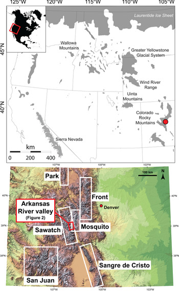
Glacial deposits corresponding to the Bull Lake (penultimate Pleistocene glaciation, Marine Isotope Stage [MIS] 6) and Pinedale (MIS 2) glaciations in the Rocky Mountains have been a focus of ongoing study since the early twentieth century (e.g., Blackwelder, Reference Blackwelder1915; Richmond, Reference Richmond, Wright and Frey1965; Porter et al., Reference Porter, Pierce, Hamilton and Porter1983; Pierce, Reference Pierce, Gillespie, Porter and Atwater2004). Similar to glacial chronologies throughout the western United States, the timing of Pinedale maxima and the onset of deglaciation vary between mountain ranges within Colorado (Leonard et al., Reference Leonard, Laabs, Plummer, Kroner, Brugger, Spiess, Refsnider, Xia and Caffee2017b). To our knowledge, Colorado glacial chronologies derived from cosmogenic nuclide exposure dating methods are available from six mountain ranges (Fig. 1; Park, Front, Sawatch, Mosquito, Sangre de Cristo, and San Juan Ranges) (Leonard et al., Reference Leonard, Laabs, Plummer, Kroner, Brugger, Spiess, Refsnider, Xia and Caffee2017b, and references therein; Brugger et al., Reference Brugger, Laabs, Reimers and Bensen2019a). These chronologies highlight differences in glacial and deglacial patterns. Numerical modeling studies have also been conducted for several paleoglacier systems, providing quantitative limits on temperature and precipitation conditions that drove Pinedale glaciation and deglaciation (Brugger, Reference Brugger2006, Reference Brugger2010; Brugger et al., Reference Brugger, Refsnider and Leonard2009, Reference Brugger, Ruleman, Caffee and Mason2019b; Ward et al., Reference Ward, Anderson, Guido and Briner2009; Dühnforth and Anderson, Reference Dühnforth and Anderson2011; Schweinsberg et al., Reference Schweinsberg, Briner, Shroba, Licciardi, Leonard, Brugger, Russell, Keller and Morgan2016; Leonard et al., Reference Leonard, Laabs, Plummer, Kroner, Brugger, Spiess, Refsnider, Xia and Caffee2017b) as well as Bull Lake glaciation (Leonard et al., Reference Leonard, Plummer and Carrara2014).
(Top) Last glacial maximum glacial extents in the western United States (gray shading; adopted from Porter et al. [Reference Porter, Pierce, Hamilton and Porter1983] and Young et al. [Reference Young, Briner, Leonard, Licciardi and Lee2011]). Red circle denotes location of the upper Arkansas River valley in the Colorado Rocky Mountains. Inset map (top left) indicates the western United States in the context of North America. (Bottom) Map of Colorado showing the mountain ranges discussed in the text. (For interpretation of the reference to color in this figure caption, the reader is referred to the web version of this article.)

Established glacial chronologies suggest that glaciers throughout Colorado reached their maximum Pinedale extents before ~23.5–19.5 ka, with near-complete deglaciation in most valleys by ~15–13 ka (all previously published 10Be ages are recalculated using the Promontory Point production rate [Lifton et al., Reference Lifton, Caffee, Finkel, Marrero, Nishiizumi, Phillips and Goehring2015] and LSDn scaling scheme [Lifton et al., Reference Lifton, Sate and Dunai2014], unless noted otherwise). However, evidence exists from the Sangre de Cristo Mountains and Sawatch Range for extensive glaciers at or near their Pinedale maxima as late as ~16 ka (Young et al., Reference Young, Briner, Leonard, Licciardi and Lee2011; Leonard et al., Reference Leonard, Laabs, Schweinsberg, Russell, Briner and Young2017a), which is similar to findings in the Wasatch Range, Utah (Laabs et al., Reference Laabs, Marchetti, Munroe, Refsnider, Gosse, Lips, Becker, Mickelson and Singer2011). By contrast, some glaciers in the San Juan Mountains may have retreated significantly from their Pinedale maximum extents as early as ~21 ka and were considerably reduced in size by ~16 ka (Guido et al., Reference Guido, Ward and Anderson2007; Ward et al., Reference Ward, Anderson, Guido and Briner2009). Except in the San Juan Mountains, moraine chronologies throughout Colorado support the concept of two Pinedale glacial culminations at ~21–20 and ~17–16 ka (Briner, Reference Briner2009; Ward et al., Reference Ward, Anderson, Guido and Briner2009; Leonard et al., Reference Leonard, Laabs, Schweinsberg, Russell, Briner and Young2017a).
The timing of deglaciation in Colorado is also variable, initiating earlier in the San Juan and Front Ranges and slightly later in the Sawatch and Sangre de Cristo Ranges (Leonard et al., Reference Leonard, Laabs, Plummer, Kroner, Brugger, Spiess, Refsnider, Xia and Caffee2017b). Several proposed hypotheses called upon global and/or regional drivers of glacial behavior to explain these inter-range asynchronies in the western United States (Licciardi et al., Reference Licciardi, Clark, Brook, Elmore and Sharma2004; Young et al., Reference Young, Briner, Leonard, Licciardi and Lee2011; Shakun et al., Reference Shakun, Clark, He, Lifton, Liu and Otto-Bliesner2015). For example, Young et al. (Reference Young, Briner, Leonard, Licciardi and Lee2011) attributed the dominant phase of glacial recession in the Sawatch Range to the temperature changes associated with the North Atlantic Bølling-Allerød warm interval (~14.7–12.9 ka; Stuiver and Grootes, Reference Stuiver and Grootes2000), although refined cosmogenic isotope production rates and scaling models leave open the possibility that the initial rise in atmospheric CO2 at ~18 ka may be the major factor driving glacial retreat (e.g., Shakun et al., Reference Shakun, Clark, He, Marcott, Mix, Liu, Otto-Bliesner, Schmittner and Bard2012, Reference Shakun, Clark, He, Lifton, Liu and Otto-Bliesner2015; Parrenin et al., Reference Parrenin, Masson-Delmotte, Köhler, Raynaud, Paillard, Schwander, Barbante, Landais, Wegner and Jouzel2013; Leonard et al., Reference Leonard, Laabs, Plummer, Kroner, Brugger, Spiess, Refsnider, Xia and Caffee2017b). However, in the San Juan and Front Ranges, as well as in other mountain ranges across the western United States (Fig. 1; e.g., Shakun et al., Reference Shakun, Clark, He, Lifton, Liu and Otto-Bliesner2015), evidence exists for earlier (pre–18 ka) glacial recession that is not readily ascribed to global or hemispheric forcings. Alternatively, regional- to local-scale mechanisms, such as precipitation forcing (e.g., Oster et al., Reference Oster, Ibarra, Winnick and Maher2015; Laabs and Munroe, Reference Laabs, Munroe, Oviatt and Shroder2016), may play a role in regulating glacial behavior in the Colorado Rocky Mountains, but the importance of regional forcing remains unclear.
To provide insight into forcings driving the spatial and temporal patterns of glacial behavior, detailed chronologies that not only mark the timing of glacial culminations but also span the onset and entirety of deglaciation are required. Although many locations in the western United States afford these dating opportunities, the upper Arkansas River valley contains some of the most extensive sequences of till and outwash in central Colorado, including well-preserved recessional moraines, many of which are in the valleys on the eastern side of the Sawatch Range (Fig. 2). Building on previous studies (Briner, Reference Briner2009; Young et al., Reference Young, Briner, Leonard, Licciardi and Lee2011; Shroba et al., Reference Shroba, Kellogg and Brandt2014; Schweinsberg et al., Reference Schweinsberg, Briner, Shroba, Licciardi, Leonard, Brugger, Russell, Keller and Morgan2016), we construct a detailed 10Be chronology for Bull Lake and Pinedale terminal moraines, Pinedale recessional moraines, and upvalley bedrock and cirque sites (Young et al., Reference Young, Briner, Leonard, Licciardi and Lee2011; Leonard et al., Reference Leonard, Laabs, Plummer, Kroner, Brugger, Spiess, Refsnider, Xia and Caffee2017b). In this paper, we present 35 new cosmogenic 10Be exposure ages that, when combined with prior work in the upper Arkansas River valley, yield a total of 82 10Be ages that collectively constrain the middle and late Pleistocene glacial history of this region.
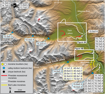
(color online) Previously published 10Be ages of glacial features in the upper Arkansas River valley. White boxes denote the locations of new 10Be ages reported in this study (see Fig. 4). 10Be ages reported with 1σ uncertainty. Circles provide approximate locations of previously sampled boulders and bedrock within the study area. All 10Be ages displayed here are recalculated using the production rate calibrated at Promontory Point (Lifton et al., Reference Lifton, Caffee, Finkel, Marrero, Nishiizumi, Phillips and Goehring2015) and the LSDn scaling framework (Lifton et al., Reference Lifton, Sate and Dunai2014) and have been previously published (Schildgen, Reference Schildgen2000; Briner, Reference Briner2009; Young et al., Reference Young, Briner, Leonard, Licciardi and Lee2011; Leonard et al., Reference Leonard, Laabs, Plummer, Kroner, Brugger, Spiess, Refsnider, Xia and Caffee2017b).

REGIONAL SETTING
Previous work
During the Bull Lake and Pinedale glaciations, Sawatch Range glaciers extended beyond the range front, forming large lateral and end-moraine complexes tied to extensive outwash sequences (Nelson and Shroba, Reference Nelson and Shroba1998; Shroba et al., Reference Shroba, Kellogg and Brandt2014). The preservation of these surficial deposits and their associated landforms has attracted many geological investigations (e.g., Hayden, Reference Hayden1874; Capps and Leffingwell, Reference Capps and Leffingwell1904; Davis, Reference Davis1905; Westgate, Reference Westgate1905; Capps, Reference Capps1909; Ray, Reference Ray1940; Richmond and Tweto, Reference Richmond, Tweto, Schultz and Smith1965; Tweto and Case, Reference Tweto and Case1972; Nelson and Shroba, Reference Nelson and Shroba1998; Schildgen, Reference Schildgen2000; Briner, Reference Briner2009; Young et al., Reference Young, Briner, Leonard, Licciardi and Lee2011; Ruleman et al., Reference Ruleman, Goehring, Mason and Lundstrom2013; Shroba et al., Reference Shroba, Kellogg and Brandt2014; Schweinsberg et al., Reference Schweinsberg, Briner, Shroba, Licciardi, Leonard, Brugger, Russell, Keller and Morgan2016; Kellogg et al., Reference Kellogg, Shroba, Ruleman, Bohannon, McIntosh, Premo, Cosca, Moscati and Brandt2017; Brugger et al., Reference Brugger, Ruleman, Caffee and Mason2019b). Although the relative ages of these moraines can be distinguished by morphostratigraphic features, such as the sharpness of moraine crests as well as boulder abundance and weathering (Nelson and Shroba, Reference Nelson and Shroba1998), numerical age constraints were recently established with cosmogenic 10Be exposure dating. Thus far, the sole attempt to date the Bull Lake glaciation in the upper Arkansas River valley was conducted in Dry Creek Gulch (Pine Creek valley), yielding 10Be ages (n = 10) from boulders and pebble collections on the left lateral moraine that range from 72 to 4 ka, all of which were interpreted to be anomalously young (Fig. 2; Briner, Reference Briner2009). Although multiple relative-age criteria suggest the possibility of a glacial advance between MIS 6 and MIS 2 in the Rocky Mountains (e.g., Colman and Pierce, Reference Colman and Pierce1986), the majority of studies reveal deposits limited to MIS 6 and/or MIS 2 in age (e.g., Pierce, Reference Pierce, Gillespie, Porter and Atwater2004; Licciardi and Pierce, Reference Licciardi and Pierce2008). It is therefore likely that the 10Be ages from Dry Creek Gulch reflect post-depositional erosional processes, such as moraine degradation, rather than the age of the Bull Lake culmination (Briner, Reference Briner2009).
More recent dating efforts have focused on identifying the timing of Pinedale glacier culminations and subsequent upvalley glacial retreat in the upper Arkansas River valley. Previously published 10Be ages indicate asynchronous Pinedale maxima at 22.3 ± 1.3, 20.0 ± 1.0, 18.4 ± 0.6, and 16.0 ± 0.9 ka for adjacent valley glaciers, which were interpreted to reflect the influence of differing glacial hypsometries and nonclimatic factors intrinsic to individual valley glacial systems (Young et al., Reference Young, Briner, Leonard, Licciardi and Lee2011; Fig. 2). By contrast, 10Be ages of glacially sculpted bedrock upvalley of the Pinedale terminal moraines in the upper Arkansas River valley suggest near-synchronous retreat of all three paleoglaciers between 16 and 15 ka and point to regional-scale climate forcings stimulating widespread glacial recession (Young et al., Reference Young, Briner, Leonard, Licciardi and Lee2011).
Building on three 10Be ages from glacially sculpted bedrock upvalley of the range front in Lake Creek valley (Young et al., Reference Young, Briner, Leonard, Licciardi and Lee2011), Leonard et al. (Reference Leonard, Laabs, Plummer, Kroner, Brugger, Spiess, Refsnider, Xia and Caffee2017b) generated four 10Be ages from bedrock within the Lake Creek cirque (Fig. 2). Some disagreement between the available ages affords two possible interpretations for the timing of near-complete deglaciation of Lake Creek valley: (1) as early as ~15 ka or (2) ~14 ka or later. Although prior numerical paleoglacier modeling provides insight into the magnitude and rate of deglaciation of the Lake Creek paleoglacier (Schweinsberg et al., Reference Schweinsberg, Briner, Shroba, Licciardi, Leonard, Brugger, Russell, Keller and Morgan2016), the two aforementioned interpretations lead to different conclusions regarding rates of ice retreat and the alignment between deglaciation and independently dated climate events, prompting further investigation. The main objective of our current study was to expand on these existing ages to develop a more complete and precisely dated chronology of the Lake Creek valley glacial system as a means of further evaluating rates of glacial retreat and connections to climatic and nonclimatic influences.
Study area
This study focuses primarily on glacial deposits in Lake Creek valley, particularly on the extensive suite of moraines surrounding the Twin Lakes Reservoir that include multiple Pinedale moraines and a Bull Lake moraine remnant (Fig. 2; Shroba et al., Reference Shroba, Kellogg and Brandt2014). Adding to the Pinedale chronology established by Young et al. (Reference Young, Briner, Leonard, Licciardi and Lee2011), we report new 10Be ages for the left lateral moraine mapped as Bull Lake in Clear Creek valley, immediately south of the Lake Creek system (Fig. 2). The only numerical age control for moraines in Lake Creek valley before this work is from two (recalculated) 10Be ages of 21.0 ± 0.6 ka (original sample ID: DC-91-3) and 19.9 ± 0.6 ka (original sample ID: DC-91-2) for boulders on the Bull Lake and Pinedale right lateral moraines, respectively (Schildgen, Reference Schildgen2000). The 10Be age of the Bull Lake boulder is considered erroneously young, which may be due to post-depositional disturbance (Schildgen, Reference Schildgen2000). Alternatively, this boulder may in fact be Pinedale in age, as recent surficial mapping (Shroba et al., Reference Shroba, Kellogg and Brandt2014) indicates extensive till mapped as Pinedale throughout the area; however, ambiguities in the reported locations of these previously dated boulders leave this issue unresolved.
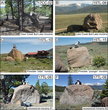
The Bull Lake and Pinedale moraines reflect the most extensive positions associated with the penultimate and last glaciation, respectively (Shroba et al., Reference Shroba, Kellogg and Brandt2014; Schweinsberg et al., Reference Schweinsberg, Briner, Shroba, Licciardi, Leonard, Brugger, Russell, Keller and Morgan2016). Till of Pinedale age is mapped as two separate units in Lake Creek valley, denoted as Pinedale “older” and Pinedale “younger,” reflecting relative age differences (Shroba et al., Reference Shroba, Kellogg and Brandt2014). The “older” moraine is a thin (few meters thick) drape of till that mantles a low, subdued Bull Lake moraine (Lee, Reference Lee2010; Shroba et al., Reference Shroba, Kellogg and Brandt2014). Directly inboard of the Pinedale “older” moraine is the much bulkier “younger” Pinedale moraine crest, ~50 m high. Recently acquired LiDAR coverage provides a high-resolution view of the moraine morphology of this complex. Given that many of the recessional moraines are preserved only as small segments, our dating efforts focused on the more prominent and continuous moraines with abundant surface boulders suitable for 10Be dating. Specifically, we report new 10Be ages for boulders on the Bull Lake left lateral moraine in Clear Creek valley (n = 4; Figs. 3A and 4B). In addition, in Lake Creek valley, we generated 10Be ages from the Bull Lake right lateral moraine (n = 4; Figs. 3B and 4A), Pinedale “older” (n = 7) and “younger” moraines (n = 7), and three recessional ridges, denoted as recessional 1 (n = 4), recessional 2 (n = 4), and recessional 3 (n = 5; Figs. 3C–F and 4A).
(color online) Photographs of selected boulders sampled in Lake Creek and Clear Creek valleys. Boulders sampled on Bull Lake moraines in Clear and Lake Creek valleys (A and B), sampled boulders from the Pinedale “outer” (C) and “younger” (D) moraines in Lake Creek valley, and boulders sampled from recessional moraine 1 (E) and recessional moraine 2 (F) in Lake Creek valley. Note weathering of Bull Lake boulder surfaces (A and B).

Summary of 10Be ages from moraine complexes in Lake and Clear Creek valleys. All 10Be ages are new, except for the ages denoted by the blue circles in Clear Creek valley (Young et al., Reference Young, Briner, Leonard, Licciardi and Lee2011). Individual 10Be ages and 1σ uncertainties are expressed in thousands of years (ka). (A) 10Be ages of boulders on moraine crests enclosing the Twin Lakes Reservoir in Lake Creek valley. (B) 10Be ages of boulders on the left-lateral Bull Lake moraine in Clear Creek valley. (For interpretation of the reference to color in this figure legend, the reader is referred to the web version of this article.)

METHODS
Sampling for 10Be dating was conducted in 2015 and 2017 (Fig. 3). Samples were collected from large boulders resting on moraine ridge crests, using a cordless angle grinder equipped with a diamond cutting disk and a hammer and chisel. Samples underwent physical and chemical processing at the University at Buffalo Cosmogenic Isotope Laboratory following previously published procedures (Licciardi, Reference Licciardi2000; Corbett et al., Reference Corbett, Bierman and Rood2016). Samples were crushed and sieved to isolate the 425–850 μm size fraction, all magnetic minerals were removed, and the remaining material was etched in dilute HCl and HF/HNO3 acid solutions. Quartz was further isolated via froth flotation techniques and additional HF/HNO3 etches until pure quartz was obtained. Beryllium was extracted to produce purified BeO target material for accelerator mass spectrometry (AMS) analysis. A commercially available 9Be carrier was added to the purified quartz samples before dissolution in concentrated HF. All 10Be/9Be ratios were measured at the Center for AMS at Lawrence Livermore National Laboratory and normalized to standard 07KNSTD3110 (10Be/9Be ratio of 2.85 × 10⁻¹²; Nishiizumi et al., Reference Nishiizumi, Imamura, Caffee, Southon, Finkel and McAninch2007).
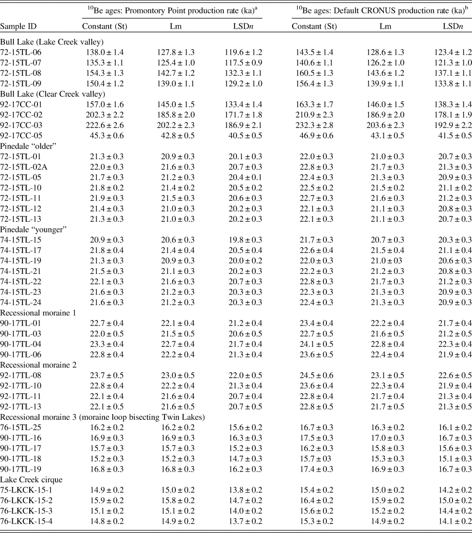
All new and previously reported 10Be exposure ages (Table 1) were calculated using the CRONUS-Earth online 10Be exposure age calculator (v. 3.0, http://hess.ess.washington.edu/math/index_dev.html; Balco et al., Reference Balco, Stone, Lifton and Dunai2008). To ensure comparability of our ages with those of recent publications (e.g., Licciardi and Pierce, Reference Licciardi and Pierce2018; Brugger et al., Reference Brugger, Laabs, Reimers and Bensen2019a), we use the regionally calibrated Promontory Point 10Be production rate (Lifton et al., Reference Lifton, Caffee, Finkel, Marrero, Nishiizumi, Phillips and Goehring2015) and LSDn scaling model (Lifton et al., Reference Lifton, Sate and Dunai2014). The Promontory Point measurements include data from sites relatively close in proximity and elevation to our study area; thus, the use of this production rate minimizes uncertainties related to scaling. For comparison, 10Be exposure ages were also calculated using alternative production rates and scaling models (Table 2).
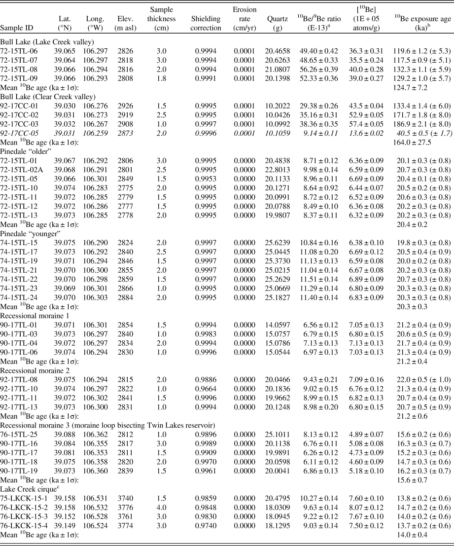
Sample information, cosmogenic isotope data, and surface exposure ages for Lake Creek and Clear Creek valleys.

a 10Be/9Be ratios are batch-specific, blank-corrected, and reported with 1σ (internal) uncertainty. Batch-specific process blanks yielded values of 4.3 × 10⁻¹⁶ (72-Blank), 3.1 × 10⁻¹⁵ (74-Blank), 2.4 × 10⁻¹⁵ (90-Blank), and 9.6 × 10⁻¹⁶ (92-Blank). AMS uncertainties ranged from 0.7% to 1.2%, 1.1% to 2.2%, and 1.3% to 1.6% for all Bull Lake, Pinedale, and Lake Creek cirque samples, respectively.
b All samples, including the Lake Creek cirque data (Leonard et al., Reference Leonard, Laabs, Plummer, Kroner, Brugger, Spiess, Refsnider, Xia and Caffee2017b), were spiked with ~225–230 μg of 9Be prepared by the GFZ German Research Center for Geosciences (“Phenakite” standard, 9Be concentration: 372 ± 3.5 ppm) at the University at Buffalo. 10Be ages are calculated using a sample density of 2.65 g/cm3 and an effective attenuation length of 160 g/cm2. 10Be ages are reported with 1σ uncertainty; the value in the parentheses reflects the external uncertainty. Negligible erosion is assumed for samples of Pinedale age and younger. Bull Lake samples are reported with an erosion rate of 1 mm/ka. Sample in italics are considered outliers and are not included in the mean 10Be age calculation.
c Data published by Leonard et al. (Reference Leonard, Laabs, Plummer, Kroner, Brugger, Spiess, Refsnider, Xia and Caffee2017b).
10Be exposure ages and alternative production rates and scaling schemes.

b Balco (Reference Balco2017).
Note: Abbreviation “St” refers to time-independent scaling (constant production rate) after Lal (1991) and Stone (2000). “Lm” is the time-dependent version of St based on time-variation in the dipole magnetic field intensity, as formulated by Nishiizumi et al. (1989).
RESULTS
Bull Lake glaciation
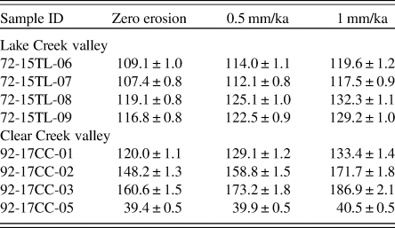
Unlike Pinedale boulders and glacially sculpted bedrock in the upper Arkansas River valley, which preserve evidence of original glacial smoothing and striations, boulders associated with Bull Lake deposits exhibit signs of weathering, including grain-to-grain relief and local spalling near the base of the boulders, presumably due to wildfires. As a result, the impact of erosion must be considered in the exposure age calculations. The Bull Lake ages are calculated with an assumed erosion rate of 1 mm/ka (Tables 1 and 3), which has been previously estimated for granitic boulders in similar climates within the western United States (Benedict, Reference Benedict1993; Gosse et al., Reference Gosse, Klein, Evenson, Lawn and Middleton1995) and used for calculating Bull Lake 10Be ages in adjacent mountain ranges (Brugger et al., Reference Brugger, Laabs, Reimers and Bensen2019a).
Erosion rates and 10Be exposure age calculations for Bull Lake samples.

Note: All 10Be exposure ages calculated using the Promontory Point production rate (Lifton et al., Reference Lifton, Caffee, Finkel, Marrero, Nishiizumi, Phillips and Goehring2015) and LSDn scaling framework (Lifton et al., Reference Lifton, Sate and Dunai2014).
10Be ages from Bull Lake moraine boulders in Lake Creek range from 132 to 120 ka and yield a mean age of 125 ± 7 ka (n = 4). With a 10Be age well outside the 2σ range of the 10Be age population, we excluded one boulder age as a young outlier (sample 92-17CC-05, 40.5 ± 0.5 ka) from the Bull Lake unit in Clear Creek valley; thus, 10Be ages from the Bull Lake moraine in Clear Creek valley are 187 ± 2, 172 ± 2, and 133 ± 1 ka (Table 1).
Pinedale glaciation
In total, 27 new 10Be ages were developed from large crystalline boulders on moraines mapped as Pinedale near the Twin Lakes Reservoir in Lake Creek valley (Fig. 3, Table 1). The ages of boulders on the Pinedale “older” moraines range from 20.7 ± 0.3 to 20.1 ± 0.3 ka, averaging 20.4 ± 0.2 ka (n = 7). 10Be ages of boulders on the Pinedale “younger” moraines range from 20.7 ± 0.3 to 19.8 ± 0.3 ka, and average 20.3 ± 0.3 ka (n = 7). The mean 10Be ages for the Pinedale “older” and “younger” moraines overlap within 1σ uncertainty. Directly inboard of the Pinedale “younger” moraine is the oldest recessional moraine (recessional 1), from which we obtained 10Be ages ranging from 21.7 ± 0.4 to 20.6 ± 0.5 ka, yielding a mean age of 21.2 ± 0.4 ka (n = 4). Similarly, the 10Be ages for recessional moraine 2 range from 22.0 ± 0.5 to 20.7 ± 0.4 ka, averaging 21.2 ± 0.6 ka (n = 4). Although the 10Be ages of boulders on recessional moraines 1 and 2 are older than 10Be ages on the outboard Pinedale “older” and “younger” moraines, all 10Be ages overlap within 2 SDs (see “Interpretation and Discussion”). Finally, five boulders from recessional moraine 3, which bisects the Twin Lakes Reservoir, range from 14.7 ± 0.3 to 16.3 ± 0.3 ka, yielding a mean 10Be age of 15.6 ± 0.7 ka.
INTERPRETATION AND DISCUSSION
Bull Lake glaciation
Our 10Be ages of Bull Lake moraine boulders in Clear Creek and Lake Creek valleys build on the few other dated Bull Lake glacial deposits in Colorado. Bull Lake deposits dated with cosmogenic isotopes have been reported in six other studies, two of which reported anomalously young boulders on Bull Lake deposits. After flagging four boulders as outliers due to problematic issues with erosion, sediment/snow shielding, and/or 36Cl complications, Benson et al. (Reference Benson, Madole, Phillips, Landis, Thomas and Kubik2004) reported a single, interpreted as reliable, 10Be age of ~144 ka for a boulder in the Front Range (data not recalculated). Similarly, 10Be ages of deposits mapped as Bull Lake in age from Pine Creek valley in the upper Arkansas River valley were also determined to be anomalously young (Briner, Reference Briner2009). In contrast, Brugger et al. (Reference Brugger, Laabs, Reimers and Bensen2019a) dated a Bull Lake moraine in Iowa Gulch in the adjacent Mosquito Range, yielding a mean age of 130 ± 5 ka (n = 2), which is consistent with our mean 10Be age of 125 ± 7 ka in Lake Creek valley. Results from Lake Creek valley are also broadly consistent with mean 10Be and 26Al ages of 101 ± 21 and 122 ± 26 ka, respectively, from boulders on Bull Lake moraines in the Front Range (Dethier et al., Reference Dethier, Schildgen, Bierman and Caffee2000; data not recalculated), and with 10Be and 26Al ages of 133 ± 28 and 139 ± 31 ka, respectively, on a Bull Lake terrace in the same range (Schildgen et al., Reference Schildgen, Dethier, Bierman and Caffee2002; data not recalculated, insufficient sample information available). Ages from Iowa Gulch and Lake Creek valley are younger than 10Be ages from Clear Creek valley, which range from 187 to 133 ka, suggesting possible isotopic inheritance for the two oldest Clear Creek samples.
Although some 10Be ages of Bull Lake boulders in Clear Creek valley are older than other Bull Lake moraines in Colorado, relatively older age constraints on Bull Lake deposits have been reported from the Zeigler Reservoir fossil site in Colorado (158 ± 9 ka; Mahan et al., Reference Mahan, Gray, Pigati, Wilson, Lifton, Paces and Blaauw2014), the Greater Yellowstone Glacial System (150 ± 4 ka; Licciardi and Pierce, Reference Licciardi and Pierce2018) and the Wind River Range in Wyoming (>130 ka; Phillips et al., Reference Phillips, Zreda, Gosse, Klein, Evenson, Hall, Chadwick and Sharma1997; Gosse and Phillips, Reference Gosse and Phillips2001). After excluding the anomalously young ages, 10Be age estimates from Clear and Lake Creek valleys, in conjunction with other dated Bull Lake deposits, indicate that most dated Bull Lake moraines were deposited during MIS 6. We note, however, that the range of ages limits our ability to confirm that moraine deposition was regionally synchronous throughout the penultimate glaciation.
Pinedale glaciation and subsequent retreat
Chronology and geomorphology
10Be ages obtained on end moraines mapped as Pinedale in age in Lake Creek valley range from 21.7 to 19.8 ka (Fig. 4). Four distinct moraine positions returned essentially identical 10Be age populations, suggesting that these moraines were deposited within a short time period. The 10Be ages of boulders on recessional moraines 1 and 2 do not obey chronological expectation at face value; however, uncertainties within 2 SDs allow for the interpretation that all four moraines (recessional moraines 1 and 2 and the Pinedale “older” and “younger” moraines) were deposited within ~1000 yr or less. We do not believe that the age reversal is due to geologic uncertainties, as we cannot envision a scenario that would give rise to a ~1000 yr apparent age difference between the two outer Pinedale moraines and the two recessional moraines. Such a scenario would either require samples on the outer moraines to have experienced systematic, enhanced erosion or partial exhumation, or for samples on the inner moraines to systematically contain isotopic inheritance. Laboratory and/or analytical complications were also considered, as samples from the two recessional moraines were processed in the laboratory later than, and separately from, the samples from the two outer Pinedale moraines. Similarly, the data were measured via AMS at different times. The difference in moraine ages does not lie in process-blank subtraction; whether using the laboratory average or batch-specific values, the resulting age differences are less than 100 yr. The 9Be carrier was the same for all samples, and the carrier concentration would not have changed in the months of time elapsed between chemistry batches. Finally, technicians at the AMS facility did not report any issues related to the primary and secondary standards (Zimmerman, S., personal communication, 2019). Thus, we see no obvious explanation for the age reversal.
The positions of the landforms—four closely spaced moraines overlapping in age, in addition to a considerably less bulky outer moraine (Pinedale “older”) adjacent to a large, well-defined moraine (Pinedale “younger”)—could be interpreted to support the influence of interannual climate variability on glacial fluctuations. Some models suggest that climate noise (weather) may potentially drive kilometer-scale oscillations in glacial extent that are beyond climatically driven glacier behavior (Anderson et al., Reference Anderson, Roe and Anderson2014). It is surprising that the larger and more prominent “younger” Pinedale moraine was not statistically younger than the thin drift comprising the Pinedale “older” moraine, as we would have expected that more time was needed to construct a moraine of that size. As such, we propose two possible interpretations for the deposition of the Pinedale-age moraines dated in this study: (1) the Lake Creek paleoglacier deposited each moraine in stratigraphic order, initially depositing the Pinedale “older” and then “younger” moraine, followed by recessional moraines 1 and 2, all within a period of ~1000 years or less; or (2) the Lake Creek paleoglacier initially stabilized at the Pinedale “younger” position, depositing till and building that moraine, and then advanced briefly to the Pinedale “older” position without removing the inner moraine. The glacier would have then retreated back to reoccupy the “younger” position, depositing till and ultimately the boulders we collected for 10Be dating. In the latter scenario, there would have been a near-maximum extent of the Lake Creek paleoglacier achieved at an unknown time before ~21 ka.
The timing of the Pinedale maximum extent in Lake Creek valley is consistent with the timing of other Pinedale maxima in the upper Arkansas River valley, although not all phases of Pinedale maxima are expressed in each valley (Fig. 5A). The oldest Pinedale ice limit is preserved in Pine Creek valley (22.3 ± 1.3 ka; Young et al., Reference Young, Briner, Leonard, Licciardi and Lee2011), whereas 10Be ages from Lake and Clear Creek valleys suggest that ice initially retreated from its Pinedale maximum extent at 20.6 ± 0.6 and 20.0 ± 1.0 ka, respectively. The synchronicity in Lake Creek and Clear Creek valleys suggests regional-scale climate forcing driving glacial behavior. Furthermore, considering uncertainties, the glacial culmination dated to 22.3 ± 1.3 ka in Pine Creek valley is essentially synchronous with the timing of Pinedale maxima in Lake and Clear Creek valleys, an interpretation inconsistent with that of Young et al. (Reference Young, Briner, Leonard, Licciardi and Lee2011). Moreover, the younger mode of 10Be ages at 16.0 ± 0.9 ka in Pine Creek valley (Young et al., Reference Young, Briner, Leonard, Licciardi and Lee2011) overlaps with the recessional moraine in Lake Creek valley dating to 15.6 ± 0.7 ka, potentially demonstrating synchronous behavior of two valley glacial systems at this point during the last deglaciation. Undated recessional moraines in Clear Creek valley (Fig. 4B) may correspond to this age as well. Overall, the glacial chronologies from Pine Creek and Lake Creek valleys support the concept of at least two periods of near-maximum ice extent during Pinedale times, one at ~21–20 ka and another at ~16 ka (Licciardi et al., Reference Licciardi, Clark, Brook, Pierce, Kurz, Elmore and Sharma2001, Reference Licciardi, Clark, Brook, Elmore and Sharma2004; Munroe et al., Reference Munroe, Laabs, Shakun, Singer, Mickelson, Refsnider and Caffee2006; Refsnider et al., Reference Refsnider, Laabs, Plummer, Mickelson, Singer and Caffee2008; Ward et al., Reference Ward, Anderson, Guido and Briner2009; Leonard et al., Reference Leonard, Laabs, Plummer, Kroner, Brugger, Spiess, Refsnider, Xia and Caffee2017b).
Comparison of upper Arkansas River valley Pinedale 10Be chronologies with climate forcings. (A) Probability density plots of 10Be ages for individual moraines (black curves) and boulders (light gray curves) in Lake, Clear, and Pine Creek valleys (this study and Young et al., Reference Young, Briner, Leonard, Licciardi and Lee2011). (B) Normalized glacial length history in Lake Creek valley. (C) Summer (June, July, and August) insolation curve at 45°N (Berger and Loutre, Reference Berger and Loutre1991). (D) Interval of deglacial CO2 rise adopted from Shakun et al. (Reference Shakun, Clark, He, Lifton, Liu and Otto-Bliesner2015); shown by the gray vertical bar. (E) Timing of the dominant high stand of a compilation of paleolakes in the Great Basin (Munroe and Laabs, Reference Munroe and Laabs2013, and references therein); shown by green horizontal bar. Vertical pink bar indicates the Bølling-Allerød warm interval (~14.7–12.9 ka). (For interpretation of the references to color in this figure legend, the reader is referred to the web version of this article.)

Deglaciation of Lake Creek valley
Our data indicate that the Lake Creek paleoglacier culminated at ~21–20 ka, followed by several glacial readvances and/or stillstands that are indistinguishable in age from the maximum position. Subsequently, there was either recession or a retreat and readvance to the innermost recessional moraine, which was abandoned at ~15.6 ± 0.7 ka.
By combining our results with previously dated samples, we reconstruct the pattern of deglaciation for the entirety of Lake Creek valley (Fig. 5B). We consider the final deglaciation of Lake Creek valley to have initiated at 15.6 ± 0.7 ka (mean age of boulders from recessional 3, n = 5) and ended at 14.0 ± 0.4 ka (mean age of cirque bedrock samples, n = 4). Thus, if we consider the first valley-bottom bedrock age downvalley from the cirque to be anomalously young (13.5 ± 0.3 ka; Fig. 2), there was a 82% reduction in glacier length between ~15.6 and 14.0 ka in Lake Creek valley. In comparison, the Lake Creek paleoglacier lost only 18% of its length between ~21 and ~15.6 ka (Fig. 5B), and Pine Creek glacier was at nearly 100% of its maximum length at ~20 and ~16 ka.
The timing of deglaciation spans a broad interval throughout Colorado, with downvalley age constraints placing the initiation of widespread ice retreat between ~20 and 16 ka, and most records revealing that valleys were nearly ice free by ~15–13 ka (Leonard et al., Reference Leonard, Laabs, Plummer, Kroner, Brugger, Spiess, Refsnider, Xia and Caffee2017b). Deglaciation began as early as ~20 ka in valleys in the San Juan Mountains and Front Range, with nearly complete deglaciation in these ranges by ~14–13 ka (Guido et al. Reference Guido, Ward and Anderson2007; Ward et al., Reference Ward, Anderson, Guido and Briner2009). Prior studies suggest that the oldest 10Be ages in these valleys may reflect 10Be inheritance rather than early deglaciation (Leonard et al., Reference Leonard, Laabs, Plummer, Kroner, Brugger, Spiess, Refsnider, Xia and Caffee2017b). In the Front Range, asynchronous deglaciation has been reported in adjacent valleys, with the onset and completion of deglaciation differing between valleys by ~2–3 ka; Ward et al. (Reference Ward, Anderson, Guido and Briner2009) attributed this difference to valley hypsometry.
In contrast to the valleys in the Front Range and San Juan Mountains, major deglaciation in the Sangre de Cristo Mountains (Leonard et al., Reference Leonard, Laabs, Schweinsberg, Russell, Briner and Young2017a) and in the upper Arkansas River valley did not occur until ~16–15 ka (Young et al., Reference Young, Briner, Leonard, Licciardi and Lee2011; Table 1). New data from Lake Creek valley similarly indicate an interval of rapid ice recession that resulted in nearly complete deglaciation occurring from ~16 to 14 ka. No clear evidence for a glacial readvance or stabilization during the Younger Dryas interval was identified in Lake Creek valley, likely due to the cirque floors being lower than the regional equilibrium-line altitude at that time in the Sawatch Range. This result is similar to those reported for other sites in Colorado (Leonard et al., Reference Leonard, Laabs, Plummer, Kroner, Brugger, Spiess, Refsnider, Xia and Caffee2017b), except for some sites in the Front Range (Menounos and Reasoner, Reference Menounos and Reasoner1997; Marcott et al., Reference Marcott, Clark, Shakun, Brook, Davis and Caffee2019).
Regional Pinedale glaciation patterns and paleoclimatic implications
Evidence for two phases of near-maximum Pinedale ice extent is now identified in multiple valleys in the upper Arkansas River valley (Fig. 5A), supporting the concept of two phases of extensive mountain glaciation in the U.S. Rocky Mountains (~21–20 and 17–16 ka; Licciardi et al., Reference Licciardi, Clark, Brook, Pierce, Kurz, Elmore and Sharma2001, Reference Licciardi, Clark, Brook, Elmore and Sharma2004; Munroe et al., Reference Munroe, Laabs, Shakun, Singer, Mickelson, Refsnider and Caffee2006; Refsnider et al., Reference Refsnider, Laabs, Plummer, Mickelson, Singer and Caffee2008; Ward et al., Reference Ward, Anderson, Guido and Briner2009; Leonard et al., Reference Leonard, Laabs, Plummer, Kroner, Brugger, Spiess, Refsnider, Xia and Caffee2017b). Although Pine Creek and Lake Creek valleys exhibit evidence for till deposition and moraine development at similar times (16.0 ± 0.9 and 15.6 ± 0.7 ka, respectively), the moraine morphologies and associated glacial fluctuations differ between valleys. Pine Creek glacier likely reoccupied the same (terminal) ice limit, generating a composite feature that resulted in a bimodal 10Be age distribution (Briner, Reference Briner2009). In contrast, Lake Creek glacier retreated and then readvanced to a position ~5 km upvalley from its prior Pinedale ice extent (at ~80% of its maximum glacial length; Figs. 4 and 5B). Thus, our results suggest a synchronous glacial response to external climate forcing that resulted in variable moraine morphologies due to the influence of local topographic factors (e.g., hypsometry, valley gradient).
Despite the steady increase in CO2 concentration initiated at ~18 ka (Fig. 5D), relatively extensive ice at ~16 ka has been documented in various mountain ranges across the U.S. Rocky Mountains (e.g., Laabs et al., Reference Laabs, Refsnider, Munroe, Mickelson, Applegate, Singer and Caffee2009; Leonard et al., Reference Leonard, Laabs, Plummer, Kroner, Brugger, Spiess, Refsnider, Xia and Caffee2017b; Licciardi and Pierce, Reference Licciardi and Pierce2018). These stable glacial configurations existed during Heinrich stade 1 (~18.0–14.7 ka), when depressed temperatures in the North Atlantic (Clark et al., Reference Clark, Marshall, Clarke, Hostetler, Licciardi and Teller2001), and perhaps in the western United States, modulated by the Laurentide Ice Sheet (Clark and Bartlein, Reference Clark and Bartlein1995), were favorable for glacial growth. However, previous studies have also postulated that regional precipitation changes during this interval may have influenced glacial behavior (Thackray et al., Reference Thackray, Lundeen and Borgert2004; Thackray, Reference Thackray2008). Highstands of many pluvial lakes in the southwestern United States about 17–16 ka (Fig. 5E; Munroe and Laabs, Reference Munroe and Laabs2013; Ibarra et al., Reference Ibarra, Egger, Weaver, Harris and Maher2014, Reference Ibarra, Oster, Winnick, Rugenstein, Byrne and Chamberlain2018), as well as speleothem records from the southwestern United States (Wagner et al., Reference Wagner, Cole, Beck, Patchett, Henderson and Barnett2010; Asmerom et al., Reference Asmerom, Polyak and Burns2010; Moseley et al., Reference Moseley, Edwards, Wendt, Cheng, Dublyansky, Lu, Boch and Spötl2016), suggest generally wetter and/or cooler conditions during this time period. Thus, enhanced moisture delivery may have contributed to glacial stabilization in some ranges of the Colorado Rocky Mountains. In addition, glaciers immediately downwind from the enlarged Great Basin pluvial lakes may have experienced further local precipitation enhancement (Laabs et al., Reference Laabs, Refsnider, Munroe, Mickelson, Applegate, Singer and Caffee2009; Birkel et al., Reference Birkel, Putnam, Denton, Koons, Fastook, Putnam and Maasch2012), but it is unlikely this effect would have extended into Colorado. Climate models and proxy records suggest that a moisture boundary existed across the Great Basin (Oster et al., Reference Oster, Ibarra, Winnick and Maher2015) during the last glacial maximum. This implies that changing moisture conditions during deglaciation may have affected precipitation patterns through the Rocky Mountains in different ways, which may provide an explanation for the observed asynchronies in deglaciation (Leonard et al., Reference Leonard, Laabs, Plummer, Kroner, Brugger, Spiess, Refsnider, Xia and Caffee2017b). Following the latter phase of Pinedale ice extent in these systems, rapid ice recession likely occurred in response to region-wide warming associated with rising atmospheric CO2 concentrations combined with increasing insolation (Fig. 5C). Whether this pulse of deglaciation in our study valleys coincided with the abrupt Oldest Dryas−Bølling transition in the North Atlantic remains an open question for future investigations.
CONCLUSIONS
We report 35 new 10Be ages from boulders on seven moraine crests spanning the Bull Lake and Pinedale glaciations in Lake and Clear Creek valleys, thereby expanding on previous work and increasing the total number of 10Be ages to 82 from three adjacent valleys that constrain the glacial history in the upper Arkansas River valley (Schildgen, Reference Schildgen2000; Briner, Reference Briner2009; Young et al., Reference Young, Briner, Leonard, Licciardi and Lee2011; Schweinsberg et al., Reference Schweinsberg, Briner, Shroba, Licciardi, Leonard, Brugger, Russell, Keller and Morgan2016; Leonard et al., Reference Leonard, Laabs, Plummer, Kroner, Brugger, Spiess, Refsnider, Xia and Caffee2017b). Bull Lake boulders in Lake and Clear Creek valleys range from 132 to 120 ka and 187 to 133 ka, respectively, providing the first direct ages suggesting that mapped Bull Lake moraines in this area may correlate to MIS 6. Four distinct moraine crests previously mapped as Pinedale units of different age (Shroba et al., Reference Shroba, Kellogg and Brandt2014) date to (in order) 20.4 ± 0.2 ka (Pinedale “older”), 20.3 ± 0.3 ka (Pinedale “younger”), 21.2 ± 0.4 ka (recessional 1), and 21.2 ± 0.6 ka (recessional 2), suggesting till deposition and moraine formation in rapid succession. Collectively, our chronology suggests that the Lake Creek paleoglacier was at or near its maximum Pinedale extent until 20.6 ± 0.6 ka (n = 22), then experienced a readvance and/or stillstand to 80%–85% of its Pinedale maximum length at 15.6 ± 0.7 ka (n = 5), and then underwent rapid ice retreat that was completed by ~15–14 ka.
The results of this study are consistent with the model of two regional intervals of near-maximum glacial extent during Pinedale times. Our data also support previous suggestions that relative glacial lengths during these two episodes differ among valleys due to nonclimatic factors such as glacial hypsometry (Ward et al., Reference Ward, Anderson, Guido and Briner2009; Young et al., Reference Young, Briner, Leonard, Licciardi and Lee2011). These results highlight the need for additional data sets constraining the last deglaciation in the western United States, particularly regarding the magnitude and rate of ice retreat expressed not only through geochronological data, but also in combination with numerical modeling and paleoclimate records to provide insight on regional-scale climate forcing.
ACKNOWLEDGMENTS
Funding was provided by the Colorado Scientific Society and by the Center for GeoHazard Studies at the University at Buffalo for cosmogenic measurements and fieldwork. The authors gratefully acknowledge K. Brugger, R. Kroner, C. Russell, C. Porreca, J. Tulenko, and W. Caffee for support in the field and C. Sbarra for assistance in the laboratory. We also thank all 2016 Geological Society of America field trip attendees for their thoughtful discussions.