1. INTRODUCTION
This study looks at the history of Austrian civil aviation cartography in an international context for the first time and covers the period from its origins until 1938. Early aeronautical charts from other countries have not been frequently studied during the last few years. However, while in the United States, an in-depth evaluation and assessment of civil aviation cartography has already gained momentum (e.g. Ehrenberg, Reference Ehrenberg and Akerman2006), Austria and Germany are still at the very beginning of such a process. In Central Europe, the exploration of the history of aeronautical charts started out with the studies prepared by Meine and Reents (Reference Meine and Reents1957) and Meine (Reference Meine1959). However these convey only a very superficial idea of the historical development of aeronautical charts. After this work, only Steele (Reference Steele1998) and Espenhorst (Reference Espenhorst2003; Reference Espenhorst2012) have dealt with some partial aspects of civil aviation cartography in Central Europe. The studies by Espenhorst (Reference Espenhorst2003, Reference Espenhorst2012) mainly referred to the systematisation of German aeronautical charts and to Vogel's “Chart of Central Europe”. Steele (Reference Steele1998) primarily focussed on the “International Commission on Aeronautical Maps”, the “International Air Convention” (1919) and the development of civil aviation cartography in Europe and North America during the interwar period. Kok (Reference Kok2005) researched aeronautical charts for long-range navigation between 1940 and 1970.
How did the developments in Austria progress and how intensively did Austria contribute to the debate on the standardisation of aeronautical charts on an international scale? How was the quality of Austrian aeronautical charts in comparison with similar ones from other countries? This article aims to expound on the thesis that, while the theoretical basis for aeronautical charts had principally been in place internationally during the 1910s and early 1920s with Austria contributing significantly to the relevant methodology, there had been almost no practical follow-up on this know-how in Austria before the 1950s. Generally we can distinguish three periods of Austrian civil aviation cartography between 1908 and 1938:
• 1908–1914: international importance of Austria in connection with methodological discussions and the standardisation of aeronautical charts.
• 1915–1922: no practical follow-up on this know-how in Austria between 1915 and 1922; aeronautical charts were not produced during this period.
• 1923–1938: novel aeronautical charts were produced, but Austrian output sometimes fell below international standards regarding both quantity and, in part, also quality.
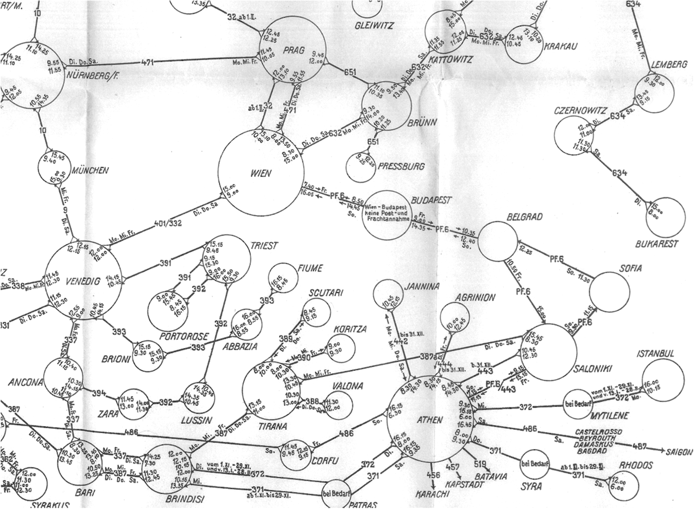
In this article the focus is on Austrian aeronautical charts drawn upon by pilots as planning and orientation aids and destined for practical use in the cockpit. These charts must not be confused with the maps produced for passengers or airlines to serve marketing purposes, which visualised for example route networks or individual routes. Usually they are not based on a specific scale and projection. Figure 1 shows a section of such a route network chart, which contains the routes of different airlines in Europe during the winter flight schedule 1932/33, departure and arrival times and some information on flight days and the price. The chart was made by the Austrian Airline “OeLAG” and is not based on a specific scale.
A section of the route network chart winter flight schedule 1932/33.
(Archive Austrian Airlines Group, Vienna International Airport).

2. AUSTRIAN CIVIL AVIATION CARTOGRAPHY 1908–1914
In Austria, the origins of aviation cartography go back to the end of the first decade of the 20th century. In that period, Austria's aviation sector experienced an upswing. After the foundation of the Austrian Aero Club in 1901, the number of balloon rides recorded a steady increase. From 1907 onward, scientific trips for meteorological, astronomical and physical observations intensified. Also the construction of airships and motorised aeroplanes was stepped up from that year (e.g. by the Austrian flight pioneer Igo Etrich, 1879–1967). In November 1909, the first Austrian airfield was inaugurated near Wiener Neustadt in Lower Austria, followed by the Vienna-Aspern airfield in 1912 (Keimel, Reference Keimel1981).
In many other countries the embryonic aviation sectors also experienced an upswing in the first decade of the 20th century. To name only two of the many highlights: In 1899 the German count Ferdinand von Zeppelin (1838–1917) began to construct his airships and in 1903 the brothers Wilbur and Orville Wright made the first sustained, controlled, powered flights. In the second half of the first decade the construction of motorised aeroplanes, airships and sailplanes became more and more important.
At the same time the interest in producing aeronautical charts increased. The German artillery officer and aviation pioneer Hermann Moedebeck (1857–1910) is today considered the “spiritual godfather of aeronautical charts” (Steele, Reference Steele1998. P.203). He formulated his first suggestions on aeronautical charts in his 1888 written article “Ueber das Landen mit Ballons” (“On Balloon Landing”). He took up his idea again in 1906. Over the next few years, he produced the map sheet “Cöln” (scale 1:300,000), which is among the world's oldest aeronautical charts (1909). This chart attracted major interest in the following years mainly because of the chart legend devised by Moedebeck. In other countries, similar projects were undertaken during the same period, such as the sheet “Châlons” of the planned “Carte aéronautique de la France”, the “Vliegkaart van Midden-Nederland” and the “Aeronautical Map of Western Long Island” (Meine, Reference Meine1959. P.27–28).
Moreover, after 1907, particularly in Germany and France, the idea grew to make an international harmonisation of aeronautical charts. Therefore “before World War I began, the Western European countries, notably France and Germany, had the lead in air map development. Britain and the United States lagged” (Steele, Reference Steele1998. P.205). The necessity of international standardisation resulted from cross-border flights, since different charts with varying scales, legends and symbols would clearly increase risk. For this reason, an “International Commission for Aeronautical Charts” was set up, which in 1908 united representatives from Belgium, Germany, France, Japan, Italy, East India, Russia and Spain as well as Austria (Moedebeck, Reference Moedebeck1908. P.147–148).
For Austria as for many other countries, this “International Commission” became the starting-point of aeronautical chart production. Austria's representative in the Commission was First Lieutenant Franz Baron von Berlepsch (Moedebeck, Reference Moedebeck1908. P.148), the first trained airship balloon pilot of the Imperial and Royal Army. At this point, it should be mentioned that in these early years no distinction was generally made between military and civil aviation cartography; both civil cartographers and map publishers and military institutions were engaged in this process.
Over the next few years, the Austrian cartographer Karl Peucker (1859–1940) was to acquire international importance. At the time, Peucker was one of the most highly regarded cartographers. He studied geography, history and German studies in Berlin and Breslau (today's Wrocław in Poland). In 1890 he moved to Vienna and was appointed the scientific director of the cartography department of the Viennese publishing house Artaria. Peucker also gave lectures on mapping at the “Vienna Export Academy” (today's Vienna University of Economics and Business) (Bernleithner, Reference Bernleithner1983. P.19). His fame was mainly due to his research into terrain visualisation for medium- and small-scale maps. Peucker experimented with different tints for different elevation ranges and published his principal work “Schattenplastik und Farbenplastik. Beiträge zur Geschichte und Theorie der Geländedarstellung” (“Contributions to the history and theory of relief representation”; 1898). Topographical maps taken as a basis “he created the idea of representing vertical intervals by using an arrangement of colours, whose sequence should give an optical stereographic impression. He distinguished between bright and rich colours and the sequence in the spectrum. His idea was to choose natural colours, following the rule: the higher the mountain, the richer the colour. The richness of colours should increase the impression of plasticity (Farbenplastik). As well as this first idea, Peucker also studied the concept of aerial perspective in relation to relief representation by colour tints. Colours should be used to convey an impression of aerial perspective.” (Kretschmer, Reference Kretschmer1988. P.12) (Figure 2).
A section of a layered relief map by Peucker
(Library University of Vienna I-366859).
While Peucker initially had applied his new method of layered relief maps mainly to classic-style cartography, he began in 1908 to propose his colour ramp as the most suitable method for elevation modelling in aeronautical charts (Peucker, Reference Peucker1908). At that time as well as most of the time between the two wars, there was no alternative to visual flight due to the fact that no aircraft attitude reference was available to indicate and control attitude in clouds without reference to the earth below and a proper well-defined horizon. Above all, in mountainous areas, where pilots often had to navigate across valleys and passes, reliable terrain visualisation was essential. For this reason pilots often used only topographical maps; but layered relief maps specially adapted for aviation were very useful for navigation.
Even before Peucker, the German publisher Ravenstein, Ferdinand Count Zeppelin and Max Gasser had called for layered relief visualisation in aeronautical charts and created the first test prints using different tints (Vogel, Reference Vogel1911). However, it was mostly Peucker's tint-based approach that was discussed internationally from 1910 onward. He published his monograph on the topic “Höhenschichtenkarten. Studien und Kritiken zur Lösung des Flugkartenproblems” (“Layered Relief Maps. Studies and Critiques towards the Solution of the Problem of Aeronautical Charts”), and spoke about his method at the conferences of the earlier mentioned “International Commission for Aeronautical Charts”.
The first conference took place in Brussels in 1911; for the Austrian side, it was attended by Peucker and the geodesist and army officer Theodor Scheimpflug (1865–1911) of the Austrian Military-Geographical Institute (MGI). Scheimpflug was a pioneer of aerophotogrammetry and aerial photographic maps. At the conference, he preferred these photographic maps as an orientation aid for pilots. However, his proposal was not taken up and pursued any further (Scheimpflug, Reference Scheimpflug and Hoernes1911).
The second conference took place in June 1912 in the Urania building in Vienna and was organised by the Imperial and Royal Austrian Aeronautical Engineering Association. Under the leadership of Prince Roland Bonaparte, 25 participants from Belgium, Germany, France, the United Kingdom, the Netherlands, Austria and Switzerland discussed the status quo in cartography. In addition to meetings and lectures, the participants also enjoyed a dinner at the Hotel Imperial and took part in guided tours of the MGI and the International Aviation Exhibition at the Vienna trade fairgrounds. (Wiener Luftschiffer-Zeitung – Anonymous, 1912; Keimel, Reference Keimel1981. P.116–118)
During the deliberations, Peucker submitted a test chart “Vienna and its Environs” (1:200,000), which rendered elevations using his own system of layer-tinting. Other data of relevance for aviation, such as buildings, streets, railway lines, above ground power lines, hangars and gasometers, were shown by means of geometrical symbols, concrete symbols and line symbols. In addition to Peucker and the MGI, the Imperial and Royal Austrian Aero Club, the Imperial and Royal Austrian Aeronautical Engineering Association and the Viennese neurologist and aviation pioneer Constantin Baron von Economo (1876–1931) likewise participated in the production of this chart.
In the end, Peucker succeeded in convincing Germany, Switzerland and Italy of his layered relief model. For example, the German Aeronautical Association decided to have a chart of part of the Rhine region with graduated-tint terrain visualisation produced in order to test this approach. On the basis of Peucker's work, the “Commission for the Production of the German Aviation Chart” planned in 1912 to create a uniform series of charts covering the entire territory of the German Empire at a scale of 1:200,000 (Peucker, Reference Peucker1911a; Artaria, Reference Artaria1917; Meine, Reference Meine1959. P.26). However, none of these projects proceeded beyond the stage of some preparatory work. Peucker's idea to compile aeronautical charts making use of his elevation modelling technique was implemented only to a minimal degree before the First World War due to the huge typographical effort involved (Siemer, Reference Siemer and Gall2007. P.93). Instead, the adaptation of existing topographical maps for aeronautical charts was gradually undertaken in Austria and other European countries. The basis chosen for this endeavour in Austria was the “Generalkarte” (“General Map”) produced by the MGI at a scale of 1:200,000 (260 sheets), into which symbols for electrically illuminated places, railway stations, railway lines, power lines, hangars, watchtowers, prohibited areas (military facilities), vineyards, hop gardens, churches, castles and factories were integrated (Figure 3) (Vogel, Reference Vogel1911).
“Generalkarte” produced by the MGI with aeronautical legends (1914, sheet Vienna)
(Austrian National Library K I 114487 Kar).
In the years before the First World War, France was the only state to produce a larger number of aeronautical charts (Ehrenberg, Reference Ehrenberg and Akerman2006. P.214). In Austria and most other countries, the project of creating internationally standardised aeronautical charts across all regions was implemented only rudimentarily. The First World War spelled an end to this venture for some time (Artaria, Reference Artaria1917; Meine and Reents, Reference Meine and Reents1957. P.35). Some European countries created their own aeronautical charts, mainly for military reasons. “The most notable development of the war was the strip map” and “the USA, with its own vast resources, had largely caught up with Europe by 1918”. (Steele, Reference Steele1998. P.205. For more information on aeronautical maps produced in the USA between 1914 and 1918 see Ehrenberg (Reference Ehrenberg and Akerman2006. P.217–229)). In Austria no aeronautical charts were produced during the First World War. Austrian military pilots mostly used topographical maps and the aeronautical maps that were produced before 1914.
3. AUSTRIAN CIVIL AVIATION CARTOGRAPHY 1923–1938
After the First World War, civil aviation experienced a major upswing above all due to the establishment of numerous airlines and the manufacturing of novel aircraft able to travel longer distances. For example nonstop Atlantic crossings were now possible. As a result, international efforts to produce standardised aeronautical charts were resumed. In this respect, the pace was set mainly by the “International Commission for Air Navigation” established in 1919 in the context of the Paris peace conferences. The “Commission” instructed the states to produce uniform charts. (Steele, Reference Steele1998. P.206) However, during the interwar period the rules determined were sometimes interpreted by the various countries in keeping with their individual requirements, which prevented any full standardisation of aeronautical charts (Meine and Reents, Reference Meine and Reents1957. P.36–39). Not all states were ready to engage in the free exchange of aviation-relevant data and surveying results, mainly for military considerations.
In Austria, no aeronautical charts were produced immediately after the First World War as a result of the terms of the Saint Germain peace treaty, which forcibly and drastically restricted Austria's civil and military aviation during the first post-war years. Activities to create aeronautical charts were only resumed from the mid-1920s onward as a consequence of both the increasing number of amateur pilots and the foundation of the first Austrian airline (“Österreichische Luftverkehrs AG” known as “OeLAG”). In 1923, the Federal Ministry of Trade and Transport granted a licence to OeLAG (Lenotti, Reference Lenotti1982. P.87–88).
Compared with the period before the First World War, Austrian aeronautical cartography presented no continuity: Karl Peucker had lost interest in aeronautical charts; as a result, his system of graduated elevation tinting was no longer pursued on either a national or international level. The initiative now lay mainly with the Austrian Federal Ministry of Trade and Transport, the Viennese Freytag & Berndt Publishing House and OeLAG. Compared to the time before 1914, entirely novel aeronautical charts were produced, such as airport maps, route maps and various individual map sheets.
3.1. Airport maps
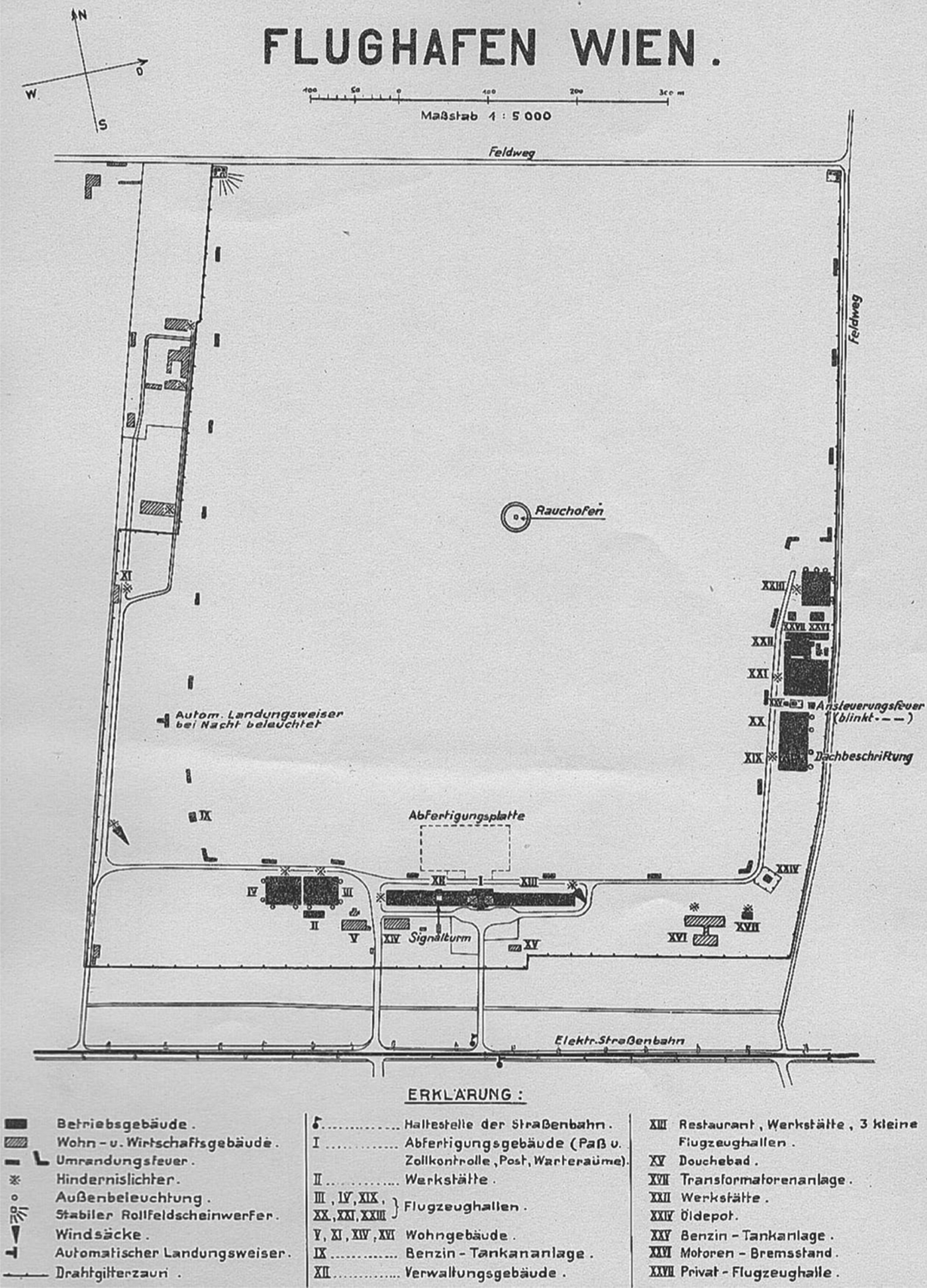
On behalf of the Austrian Federal Ministry of Trade and Transport, maps of Austria's public and private airports and airfields were produced in the 1920s and 1930s by airport employees and mainly printed by the “Cartographical, formerly Military-Geographical Institute” (Austrian State Archives ÖStA, Adr BM f HuV/VS, Kt. 517). They were meant for all foreign private and airline pilots and featured a uniform legend system for all symbols. Line symbols were used to mark airport and taxiway borders as well as telegraph and power lines. Geometrical and concrete symbols were created for example for radio transmission towers, floodlights and boundary lights. Figure 4 shows the map of the airport Vienna- Aspern (Airport Wien-Aspern, 1930).
Map of the Airport Vienna-Aspern
(Viennese Townhall Library 256588c/1930).
3.2. Route maps
These maps were based on physical maps and facilitated visual flight navigation. However, the initiative for these maps did not lie with OeLAG but with the Viennese Freytag & Berndt Publishing House. A letter shows that Freytag & Berndt had “made it its task to address in greater detail the question of route maps, which … are destined for use not only by flight passengers but also by pilots and should contribute to increasing air traffic” (ÖStA Adr BM f HuV/VS Kt. 143). In 1927, Freytag & Berndt approached several airlines including OeLAG, the French-Romanian CIDNA and Polska Linja Lotnicza to discuss the necessity of such charts. Historical sources reveal that, of these airlines, at least OeLAG commissioned Freytag & Berndt to produce route maps. Already in November 1927, the Vienna-Prague route map was completed; further route maps followed in the coming months (e.g. Innsbruck-Zurich, Vienna-Prague-Dresden-Berlin, Salzburg-Klagenfurt and Vienna-Graz-Zagreb) (ÖStA Adr BM f HuV/VS Kt. 143).
These route maps were designed in a uniform style, as the example of the Salzburg-Zurich map shown (Figure 5) demonstrates. The map shows the flight path via the Lechtal and Allgäu Alps, Lake Constance and north-eastern Switzerland. This route is rendered by short red lines and includes distances in kilometres. The kilometre indications are given for both outbound and inbound flights. To prevent mix-ups, one direction is shown dotted and the other one as a solid line. On the side, attention is drawn to notable mountains, lakes, valleys, glaciers, railway stations, castles, monasteries, palaces and landmarks of cities (e.g. red roofs of the German town Lindau, airship hall of Friedrichshafen) that could be identified by pilots during the flight for better orientation. Two compass roses are presented, referenced to magnetic North to facilitate measuring magnetic tracks and steering related magnetic courses on the aircraft compass. Moreover, two maps at a scale of 1:100,000 are likewise given here; these show the location of the airports of Salzburg and Zurich. Perhaps these two maps can be seen as early approach charts.
Freytag & Berndt/OeLAG, Route map Innsbruck – Zurich
(Austrian National Library K II 97787 Kar).
3.3. Other aeronautical charts
In addition to airport maps and route maps, Austrian pilots could also rely on other types of charts and maps as orientation aids, which included the official map of the Austrian Aero Club and foreign cartographic works. The official map of the Austrian Aero Club (Figure 6) was printed in several languages by the “Cartographical, formerly Military-Geographical Institute”. Various editions with two different scales (1:1·500,000 and 1:500,000) were available. These charts were designed as physical maps and show for example public and private airports, seaplane landing areas, prohibited areas, national border sections for entry and exit flights, weather reporting stations, ground-to-air communication points as well as hangars. In Figure 6 you can see the legends for Alpine passes, prohibited areas (cross-hatched blue area), seaplane landing areas (a blue circle with an anchor), landing grounds for sporting pilots (blue circle) and for the Salzburg airport a blue circle divided into six sections. Five of these sections are marked in blue, which mean the existence of fuel and oil, custom formalities, weather service station, wireless station and directional wireless station at this airport. The missing section stands for the absence of public hangars.
A section of the official map by the Austrian Aero Club
(Library University of Vienna I-528.600).
In the second half of the 1930s, Austrian pilots could moreover draw on an aeronautical chart produced by the Justus Perthes Publishing House in Gotha, Germany, which also depicted the entire national territory of Austria. It was based on the “Vogel Map of Central Europe”, which originally had been designed as a topographical map by the cartographer Carl Vogel. Starting in 1936, the Justus Perthes publishing house added all data of importance for aviation in the shape of internationally standardised symbols to this map (Espenhorst, Reference Espenhorst2003. P.430–435).
4. A COMPARISON OF AUSTRIAN CIVIL AVIATION CARTOGRAPHY WITH THE INTERNATIONAL OUTPUT
At least with regard to airport maps and route maps, the Austrian output during the interwar period was hardly of inferior quality when compared with the aeronautical charts produced in other countries. Route maps in particular were created in the individual states in accordance with their specific needs and hence presented great variety. As just one example out of many, the author would like to mention the Edmonton-Lethbridge route map at a scale of 1:506,880 (Department of the Interior Topographical Survey of Canada; 1931, Figure 7). Here, too, variations in elevation are rendered in different colours, although the height levels are not as easy to distinguish as in the OeLAG maps. The Canadian chart lacks a compass rose but instead features numbers stating the magnetic compass variation directly in the map. As with the OeLAG charts, maps indicate the location of airports within city limits.
A section of the Edmonton-Lethbridge route map
(Austrian National Library K II 101726 Kar).
It seems indeed likely that no aeronautical charts other than the already presented official map of the Austrian Aero Club and its rescaled variations were produced in Austria during the 1920s and 1930s. However, the aeronautical charts created in many other countries surpassed Austrian production not only with regard to quantity but partly also featured more complex symbols and legends (e.g. the “Vogel Map of Central Europe”). In addition, numerous maps and charts exist, such as the “Carta Aeronautica d'Italia” (1:250,000; R. Aero Club d'Italia, 1930), the “Luchtvaartkaart von Nederland” (1:400,000; Bureau voor Luchttoerisme, 1937) and many other French, British (e.g. International Aeronautical Map 1:1.000,000; War Office, 1934) and U.S. charts (Ehrenberg, Reference Ehrenberg and Akerman2006). For example, the Austrian charts lack indications of power lines, which would have been of great importance for pilots flying by visual flight rules.
Most of the above mentioned aeronautical charts were created by the respective countries' aviation clubs. It is probable that the commercial airlines also compiled their own charts in addition to this material. As a rule, however, these would not have been available for use or sale; consequently, they cannot be found in modern-day libraries and map collections, contrary to the charts compiled by aviation clubs. This fact slightly complicates research, since it prevents a full overview of the actual production of aeronautical charts during the interwar period. For example the author could not find any approach and departure plates, which guided pilots during landing and take-off. Austrian Airline Souvenir Maps, which were handed out to passengers together with e.g. flight tickets, timetable, airline post cards, booklets and airmail envelopes are likewise not available in Austrian libraries and archives.
5. CONCLUSION
Between 1908 and 1914 some Austrians intensively contributed to the debate on the standardisation of aeronautical charts on an international scale. The quality of the Austrian charts was up to international standards. The cartographer Karl Peucker took the initiative and proposed his method of layered relief maps as the most suitable method for elevation modelling in aeronautical charts. In the end, Peucker succeeded in convincing Germany, Switzerland and Italy of his layered relief model. After the First World War the Austrian output sometimes fell below international standards regarding both quantity and, in part, also quality. The initiative now lay mainly with the Austrian Federal Ministry of Trade and Transport, the Viennese Freytag & Berndt Publishing House and the first Austrian Airline, OeLAG. Compared to the time before 1914, entirely novel aeronautical charts were produced, such as airport maps, route maps and various individual map sheets. During the National Socialist regime, there was no proper map production in Austria. Civil aviation cartography could only be resumed starting in the 1950s and with the foundation of Austrian Airlines in 1957.
ACKNOWLEDGEMENTS
The author would like to thank the Austrian National Library, the Austrian Airlines Group and Dr. Peter Baumgartner, the Library of the University of Vienna and the Viennese Townhall Library for the permission to print some maps, and Captain Hans Kok (KLM/IMCoS) and Sigrid Szabó for their great professional help.