Early Native American populations—known to archaeologists as Paleoindians—migrated into deglaciated portions of northeastern North America during the late Pleistocene from the adjacent Midwest and Mid-Atlantic regions. The archaeological record of these early peoples suggests that they lived at low population densities and that residential groups routinely traveled extensively during annual rounds of movement (i.e., range mobility), at scales not matched by later indigenous populations (Ellis Reference Ellis, Ellis and Lothrop1989, Reference Ellis2011; Lothrop and Singer Reference Lothrop and Singer2017; Lothrop et al. Reference Lothrop, Lowery, Spiess and Ellis2016). Here, we combine geochemical sourcing of toolstone with geographic information systems least cost path analysis to better understand the nature of these seasonal movements as indicators of Paleoindian mobility and land use in northeastern North America during the late Pleistocene.
Paleoindian sites found north of the Last Glacial Maximum (LGM) in northeastern North America are mostly marked by lithic scatters of fluted points and other flaked-stone tools and document Early Paleoindian (ca. 13,000–12,200 cal BP) and Middle Paleoindian (ca. 12,200–11,600 cal BP) populations. These peoples inhabited subarctic-like Younger Dryas environments, ranging with latitude and elevation from boreal forest to parkland to tundra. Their lifeways relied on a highly seasonal resource base that included seasonal hunting of migratory caribou (Rangifer sp.; Lothrop et al. Reference Lothrop, Lowery, Spiess and Ellis2016:228–230, 233–234; Newby et al. Reference Newby, Bradley, Spiess, Shuman and Leduc2005). This contrasts with sites of contemporaneous eastern Paleoindian populations south of the LGM who occupied more temperate pine-oak forests during the Younger Dryas and practiced less extensive range mobility (Lothrop et al. Reference Lothrop, Lowery, Spiess and Ellis2016:201–203, 225) that some link to the hunting of nonmigratory prey species in largely closed forest settings (e.g., Gardner Reference Gardner, Wittkofski and Reinhardt1989; Meltzer Reference Meltzer1988).
The recognition of more extensive Paleoindian range mobility in the formerly glaciated Northeast has prompted research on the relationship between high mobility and stone technology (e.g., Ellis Reference Ellis2008; Ellis and Lothrop Reference Ellis and Lothrop1989; Eren and Andrews Reference Eren and Andrews2013; Stothers Reference Stothers1996; Tankersley and Isaac Reference Tankersley and Isaac1990), as done elsewhere in North America (e.g., Ingbar Reference Ingbar and Carr1994; Montet-White and Holen Reference Montet-White and Holen1991). However, these assessments of Paleoindian range mobility in northeastern North America are often based solely on provisional identifications of geologic sources of artifact toolstone at individual sites, using macroscopic comparisons with source hand samples. Although a good first step, this can be prone to errors from look-alike sources (e.g., Calogero Reference Calogero1992; Tankersley Reference Tankersley, Ellis and Lothrop1989:260–261).
Some researchers have applied methods such as thin-section petrography or geochemistry (X-ray diffraction, X-ray fluorescence, instrumental neutron activation analysis) to sourcing northeastern Paleoindian assemblages (e.g., Boulanger et al. Reference Boulanger, Buchanan, O'Brien, Redmond, Glascock and Eren2015; Burke et al. Reference Burke, Gauthier and Chapdelaine2014; Kitchel Reference Kitchel2016a; Pollock et al. Reference Pollock, Hamilton and Bonnichsen1999; Pollock et al. Reference Pollock, Hamilton and Boisvert2008; Robinson et al. Reference Robinson, Ort, Eldridge, Burke and Pelletier2009; Tankersley Reference Tankersley, Ellis and Lothrop1989; Tankersley et al. Reference Tankersley, Holland and Kilmer1996; von Bitter and Eley Reference von Bitter, Eley and Storck1997). Recent applications of X-ray fluorescence (XRF) sourcing of artifact assemblages represent a desire for methodologies that are nondestructive, are quantitatively replicable, and can accommodate analysis of multiple samples at modest cost (e.g., Burke et al. Reference Burke, Gauthier and Chapdelaine2014; Gauthier and Burke Reference Gauthier and Burke2011; Gauthier et al. Reference Gauthier, Burke and LeClerc2012).
When analysis links Paleoindian artifact toolstone to a geologic source, it often leads to an inference of direct procurement, quantified by measurement of the straight-line distance between source and site. Assembled for multiple sites and sources, these data provide proxy measures of range mobility (e.g., Burke Reference Burke, Bressy, Burke, Chalard and Martin2006; Ellis Reference Ellis2011). But like any foragers—past or present—Paleoindian peoples did not travel in straight lines. Historically, Native Americans often established pathways on game trails or, governed by natural topography, chose routes along valleys, navigable rivers, or mountain passes (Zedeño and Stoffle Reference Zedeño, Stoffle, Rockman and Steele2003:62). In the subarctic, hunter-gatherers varied their modes and routes of travel seasonally: warm-season movement might include watercraft along lakes and rivers, with foot travel facilitated by the fall freeze-up of rivers, lakes, and boggy terrain (e.g., Brody Reference Brody1981; Leacock and Rothschild Reference Leacock and Rothschild1994; Sharp and Sharp Reference Sharp and Sharp2015; Tanner Reference Tanner1979).
Some archaeologists assume that in the late Pleistocene, Paleoindian seasonal travel followed routes of least resistance in valleys or lowlands to accommodate extensive range mobility (e.g., Gramly Reference Gramly, Laub, Miller and Steadman1988; Lothrop and Bradley Reference Lothrop, Bradley and Chapdelaine2012). However, there has been little explicit consideration of whether such scenarios are valid and what routes those pathways might have followed. If we can model possible routes along which people transported lithic raw materials—traveling away from and ultimately returning to one or more toolstone sources during an annual round—we can generate more meaningful distance data for measuring Paleoindian mobility through time and across regions. Further, modeling the pathways of late Pleistocene peoples can inform us on seasonal land use strategies and/or patterns of interaction in and between regions (Clarkson Reference Clarkson, Bruno and Thomas2008). To this end, geographic information systems terrain study using least cost path (LCP) analysis provides a replicable approach for projecting Paleoindian seasonal routes across late Pleistocene landscapes (e.g., Bevan Reference Bevan, Herrera, Pérez and Simposio2011; Chapman Reference Chapman2006; Herzog Reference Herzog, Bevan and Lake2013, Reference Herzog2014; Polla and Verhagen Reference Polla and Verhagen2014; White and Surface-Evans Reference White and Surface-Evans2012).
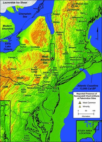
Below, we report on XRF-based geologic sourcing to evaluate reported artifact finds of one toolstone, Normanskill chert from eastern New York's Hudson Valley, at Early and Middle Paleoindian sites in northeastern North America (Figure 1). The results tentatively link many of these sites to the West Athens Hill (WAH) source of Normanskill chert. We then use LCP analysis to model routes from WAH to seven Early Paleoindian sites after toolstone acquisition. Supplemental online materials provide additional background to this study.
Paleoindian sites in northeastern North America with reported Normanskill chert artifacts, showing the Normanskill proportion of assemblage toolstone and late Pleistocene landscapes ca. 13,000 cal BP (after Dyke Reference Dyke, Ehlers and Gibbard2004). Due to scale, six sites obscure eight other site locations (in parentheses): Michaud (Lamoreau), West Athens Hill (Kings Road, Swale, Railroad #1), Dutchess Quarry Cave #1 (Soon's Orchard), Hidden Creek (Ohomowauke), 36LY99 (Warrior Spring), and Plenge (Wolverton). State/international boundaries are shown for reference only. Inset: Normanskill chert quarries in the middle-upper Hudson Valley: (A) Mount Merino; (B) West Athens Hill; (C) Mountain Top/Warren; (D) Scott Farm; (E) Flint Mine Hill; (F) Pleasantdale; (G) Fitch Road; (H) Flately Brook. LGM = Last Glacial Maximum.

Paleoindian Toolstone Use in Northeastern North America
Residual cortical surfaces (i.e., bedding and joint surfaces) on flaked-stone artifacts from Early and Middle Paleoindian sites in the formerly glaciated Northeast suggest that toolstone was routinely quarried at bedrock outcrop sources (Burke Reference Burke, Bressy, Burke, Chalard and Martin2006; Ellis Reference Ellis, Ellis and Lothrop1989, Reference Ellis2011; Lothrop et al. Reference Lothrop, Lowery, Spiess and Ellis2016). Most interpretations of toolstone procurement assume direct acquisition during residential encampments at lithic sources, a scenario that we favor. In this view, Paleoindian lithic procurement was “embedded” in larger annual rounds, but counter to Binford (Reference Binford1979), this toolstone acquisition was planned and not opportunistic (Ellis Reference Ellis2011; Lothrop et al. Reference Lothrop, Lowery, Spiess and Ellis2016; but see Seeman Reference Seeman1994; Spiess and Wilson Reference Spiess, Wilson, Ellis and Lothrop1989). Indirect acquisition of Paleoindian toolstone could have occurred through fluid band membership or exchange (e.g., Bamforth Reference Bamforth2002; Speth et al. Reference Speth, Newlander, White, Lemke and Anderson2013). Meltzer (Reference Meltzer, Ellis and Lothrop1989) and Sellet (Reference Sellet, Sellet, Greaves and Yu2006) note the potential for equifinality, that is, the possibility that similar toolstone profiles in two or more assemblages may result from different modes of procurement. In this regard, Ellis (Reference Ellis2011) argues that (1) the dominant toolstone in a Paleoindian assemblage likely represents direct procurement and (2) documented trends in directionality between toolstone sources and residential sites in the Northeast suggest toolstone acquisition during annual rounds of residential groups.
Here, we follow Ellis (Reference Ellis2011) in assuming that the most common toolstone in a northeastern Paleoindian site assemblage represents direct procurement during residential moves and further propose that artifacts of the first-tier minority (i.e., second-most common) toolstone in the same assemblage likely also reflect direct procurement, obtained earlier in an annual round. Conversely, lithics present as trace percentages may represent indirect acquisition through social interaction (Lothrop and Bradley Reference Lothrop, Bradley and Chapdelaine2012:28; but see Ingbar Reference Ingbar and Carr1994 for other possible models).
Between about 13,000 and 11,600 cal BP, Early and Middle Paleoindian populations exploited several primary toolstone sources in northeastern North America, including Normanskill chert in New York (Funk Reference Funk2004; Lothrop and Bradley Reference Lothrop, Bradley and Chapdelaine2012), Hardyston Formation jasper in Pennsylvania and New Jersey (Hatch Reference Hatch1994), Cheshire quartzite in Vermont (Crock and Robinson Reference Crock, Robinson and Chapdelaine2012), spherulitic rhyolite in New Hampshire (Kitchel Reference Kitchel2017; Pollock et al. Reference Pollock, Hamilton and Boisvert2008), Munsungun Formation chert in Maine (Pollock et al. Reference Pollock, Hamilton and Bonnichsen1999), and Minas Basin chert in Nova Scotia (Black Reference Black, Bernard, Rosenmeier and Farrell2011; Supplemental Figure 1). In New York, Devonian limestones containing cherts are exposed along the Onondaga and Helderberg escarpments of the Appalachian Plateaus (Fisher et al. Reference Fisher, Isachsen and Rickard1970). Cherts are also found in Ordovician formations of the Taconic sequence in eastern New York. Cherts commonly labeled as Normanskill by archaeologists come from two units of the Ordovician Normanskill Group (sometimes referred to as Normanskill Formation). The Mount Merino and Indian River members/formations are mapped together stretching discontinuously through the middle and upper Hudson Valley (Fisher et al. Reference Fisher, Isachsen and Rickard1970). The Mount Merino Formation cherts display radiolarian microfossils and, when unweathered, most commonly range from green to gray to black. Outcrops of the Indian River Formation may also contain green radiolarian cherts (Supplemental Text 1; Fisher Reference Fisher1977; Landing Reference Landing and Landing1988; Ruedemann and Wilson Reference Ruedemann and Wilson1936).
Normanskill chert outcrops with associated prehistoric quarries are recorded at eight locations along a 90 km section of the Hudson Valley (Figure 1, inset; Supplemental Figure 1). To the south, the outcrop quarries of Mount Merino, WAH, Mountain Top/Warren, Scott Farm, and Flint Mine Hill document Native American quarrying and reduction activity (Brumbach and Weinstein Reference Brumbach and Weinstein1999; Burke Reference Burke, Bressy, Burke, Chalard and Martin2006; Cassedy Reference Cassedy1998:34–41; Funk Reference Funk2004; Krievs and Bouchard Reference Krievs and Bouchard1992; Laccetti Reference Laccetti1989; Parker Reference Parker1924). In the upper Hudson Valley, Native Americans exploited outcrops at the Pleasantdale, Fitch Road, and Flately Brook quarries (Brumbach Reference Brumbach1987; Holland and Ashton Reference Holland and Ashton1999). WAH and Flint Mine Hill have yielded evidence of fluted point occupations, but only WAH has produced clear and substantial evidence for Paleoindian mining and reduction of Normanskill chert, including the manufacture and discard of tools of this chert (Supplemental Text 1; Funk Reference Funk2004). Moreover, the diversity of Paleoindian tool forms found at WAH strongly suggests direct procurement of this toolstone during residential encampments (Lothrop and Bradley Reference Lothrop, Bradley and Chapdelaine2012:19–20, 29).
Lothrop and Bradley (Reference Lothrop, Bradley and Chapdelaine2012:Table 2.5) have compiled reports of Normanskill chert artifacts at 35 nonquarry Paleoindian sites. An updated review documents 52 Paleoindian sites with reported artifacts of Normanskill chert (mostly from macroscopic assessments; Supplemental Table 1). These sites are found in all directions relative to WAH, at straight-line distances of up to 550 km (Figure 1). Of the 52 sites, 40 lie to the north in formerly glaciated terrain, and 12 are located south of the LGM. For 18 sites, Normanskill chert is, or appears to be, the majority or most common toolstone, at distances of up to 360 km from WAH. Associated point forms suggest that this early exploitation of Normanskill chert was heaviest during Early and Middle Paleoindian times (ca. 13,000–11,600 cal BP) and waned in the early Holocene during the Late Paleoindian (ca. 11,600–10,000 cal BP).
Some recent sourcing studies confirm the presence of Normanskill chert in northeastern Paleoindian assemblages outside of the Hudson Valley. Robinson and associates (Reference Robinson, Ort, Eldridge, Burke and Pelletier2009) report that petrographic and XRF analyses of the Bull Brook site assemblage identified Normanskill and Munsungun cherts and Hardyston Formation jasper, whose sources all lie at least 240 km from the Bull Brook site. Ort's (Reference Ort2012) macroscopic survey of the Bull Brook tool assemblage indicates that although most tools cannot be attributed to a specific source, Hardyston jasper (13%) and Normanskill chert (11%) are the most common lithics identified in the assemblage. Using XRF geochemistry, Gauthier and Burke (Reference Gauthier and Burke2010) identify Normanskill chert at the Mahan site in western Vermont, and Kitchel (Reference Kitchel2016a) documents this toolstone at the Vail site in northwestern Maine. Finally, using petrographic analysis, Singer and colleagues (Reference Singer, Leach, Rockwell, Calogero, Philpotts and Moeller2018) and Tankersley and colleagues (Reference Tankersley, Holland and Kilmer1996) demonstrate that Normanskill chert constitutes the majority toolstone at the Templeton site in northwestern Connecticut and at the Kilmer site in western New York. Collectively, the available literature suggests that Normanskill chert was an important regional toolstone for Early and Middle Paleoindian peoples in the glaciated Northeast.
Sourcing Normanskill Cherts of the Hudson Valley
Sampling Geologic Outcrops and Archaeological Sites
As part of a program to characterize Ordovician cherts in northeastern North America geochemically, Burke has systematically sampled geologic outcrops containing chert in the Normanskill Group over the last 15 years. Sampling has concentrated on a 90 km section of the Hudson Valley, from Mount Merino and Blue Hill in the south to Saratoga Lake and Willard Mountain in the north (Figure 1; Supplemental Figure 1). The study focuses on known prehistoric quarries (from south to north: Mount Merino, WAH, Scott Farm, Flint Mine Hill, Pleasantdale, Fitch Road, Flately Brook) but includes other outcrops that would have been easily accessible and visible in the past (such as Glenmont and Blue Hill). To date, 94 geologic cut and polished chert samples have been analyzed from nine sources. Geochemical data indicate significant intrasource variability and some overlap between outcrops. This suggests that a chert sample from one quarry could, on occasion, be misclassified as to specific source.
The geologic complexity and geographic extent of the Normanskill Group/Formation (Supplemental Text 1), combined with the extensive annual rounds of Paleoindians, make it difficult to establish what might be a representative catchment area for toolstone exploited by a given group. For this reason, we first focused primarily on sampling known prehistoric quarries. Only WAH has clear evidence of Paleoindian exploitation (quarrying extraction from bedrock) and reduction (extensive workshops yielding hundreds of cores, biface preforms, and fluted point manufacturing rejects). WAH is one of the rare cases in northeastern North America of unambiguous Paleoindian chert quarrying and reduction. This fact can be used to reduce the potentially large and unmanageable geochemical variability introduced by the many possible sources of Normanskill chert in the Hudson Valley. Here we employ WAH as a proxy for Normanskill chert used by Early and Middle Paleoindians. This is justified because WAH is the only clearly demonstrated Paleoindian quarry in the Normanskill Group. Moreover, the selection criteria used by Paleoindians to choose a suitable raw material make up a reasonable method of constraining the larger geologic universe. To increase our initial sample size of 18 geologic samples, we added 40 Paleoindian artifacts curated at the New York State Museum that were cut and polished for XRF analysis. These artifacts (flakes and core fragments) were chosen from excavation units and soil strata that were directly associated with diagnostic Paleoindian artifacts based on Funk's field notes (see Funk Reference Funk2004).
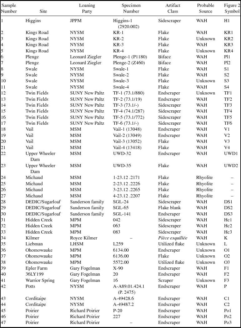
We carried out an initial exploratory geochemical and statistical analysis of the 58 chert samples to assess intrasource variability. A cutoff value of greater than 95% SiO2 was used to reduce the reference sample to using only the higher-quality chert as a proxy. For this study, our geochemical characterization of Normanskill chert relied on the analysis of a subsample of 27 specimens, including geologic samples collected from modern quarry exposures at the eastern base of WAH as well as geologic samples collected from the top of WAH and archaeological specimens excavated by Funk in the 1960s and curated at the New York State Museum (see Funk Reference Funk2004). For the archaeological component of our study, we performed XRF analysis on 47 artifacts from 19 Paleoindian sites (Table 1), with sample counts ranging from 1 to 6 artifacts per site. Artifacts chosen for analysis were judged likely to be Normanskill chert based on macroscopic characteristics.
Results of X-ray Fluorescence Sourcing Analysis of 47 Artifacts from 19 Northeastern Paleoindian Sites.

Note: JPPM = Jefferson Patterson Park and Museum; NYSM = New York State Museum; SUNY New Paltz = State University of New York at New Paltz; MSM = Maine State Museum; MPM = Mashantucket-Pequot Museum; LHSM = Lebanon Historical Society Museum; WAH = West Athens Hill.
Laboratory Sourcing Methods
We used nondestructive polarized energy-dispersive X-ray fluorescence to define the geochemical signatures of the samples, performing these analyses at the Laboratoire de Caractérisation des Matériaux Archéologiques at the Université de Montréal on a PANalytical Epsilon 5 XRF instrument. This spectrometer has a three-dimensional polarizing geometry and is equipped with a 600 W gadolinium anode side window X-ray tube, a 100 kV generator, 15 polarizing and secondary targets, and a high-resolution germanium detector. It was calibrated for the analysis of aphanitic lithic artifacts with 20 international geologic certified reference materials containing well-established element concentrations (provided by the US Geological Survey, Geological Survey of Japan, Institute of Geophysical and Geochemical Exploration, Canadian Certified Reference Materials Project, and National Institute of Science and Technology). Calibration curves were established for 10 major elements (measured as oxides: SiO2, TiO2, Al2O3, Fe2O3T, MnO, MgO, CaO, Na2O, K2O, and P2O5) and 20 trace elements (S, Cl, V, Cr, Co, Ni, Cu, Zn, As, Rb, Sr, Y, Zr, Nb, Ba, La, Ce, Pb, Th, and U). Major elements were calibrated as oxides in percent weight, and trace elements were calibrated as metals in parts per million. Gauthier and Burke (Reference Gauthier and Burke2011) and Gauthier and colleagues (Reference Gauthier, Burke and LeClerc2012) provide further details on instrument specifications, calibration protocols, and acquisition parameters for major and trace element data using the PANalytical Epsilon 5 XRF instrument, as well as a detailed discussion of instrument accuracy, precision, and limits of detection. XRF yields and analytic precision for Ordovician cherts are given in Gauthier and associates Reference Gauthier, Burke and LeClerc2012.
Sourcing Results
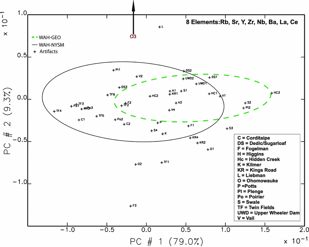
After XRF characterization of the 27 WAH source specimens, we performed a principal components analysis using eight trace elements (Rb, Sr, Y, Zr, Nb, Ba, La, Ce). We then projected the XRF data for the 47 archaeological specimens (using the Missouri University Research Reactor murrap.gcg program, version 8.3, running with the Gauss run time module; for further details, see Gauthier et al. Reference Gauthier, Burke and LeClerc2012) onto a PC1 versus PC2 graph (principal components 1 and 2), explaining 88.3% of the variance. The two ellipses drawn for the two WAH source groupings represent a 90% confidence interval. Those archaeological samples falling within or on the margins of these ellipses likely derive from WAH (Figure 2).
Results of principal components analysis for 43 chert artifacts from 18 Paleoindian sites (Table 2 lists the labels for the individual artifact samples, excluding Michaud specimens proved to be rhyolite). The two ellipses represent 90% confidence intervals for the two West Athens Hill chert reference collections: the Paleoindian quarry samples (West Athens Hill–New York State Museum [WAH-NYSM]) and the geologic samples from the modern quarry and the surface (West Athens Hill–Geologic [WAH-GEO]). Note, the Ohomowauke 3 (O3) sample is not displayed, because it plots off the chart boundary.

Results indicate that the four artifacts from the Michaud site in south-central Maine were manufactured from a rhyolite of unknown origin (Table 1). A total alkali-silica compositional diagram (Middlemost Reference Middlemost1994) clearly shows that the Michaud artifacts are made of rhyolite (Supplemental Figure 2). This particular rhyolite does not match the geochemistry of rhyolites that we have analyzed from Maine or the greater Northeast (see Burke et al. Reference Burke, Gauthier and Chapdelaine2014).
For the remaining 43 artifacts, percentages of SiO2 exceed 90% by weight, indicating that they qualify compositionally as chert. Of these, 34 artifacts (79.1%) from 15 of the remaining 18 sites fall within or lie on the margins of the two ellipses and therefore likely derive from WAH (Figure 2; Table 1). The nine artifacts that fall outside these ellipses derive from either other Normanskill chert outcrops not included in this analysis or other chert sources.
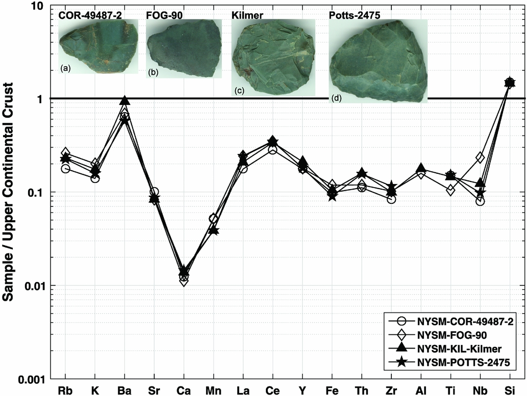
We used the same data with spider diagrams to visualize the correspondence between the geochemistry of geologic samples of WAH chert and Paleoindian artifacts. These diagrams help match specific rock geochemistry and provide a more intuitive visual approach to complement multivariate statistical analyses. Figure 3 shows a typical geochemical profile for WAH Normanskill chert as compared with artifacts from the Upper Wheeler Dam and Vail sites in northwestern Maine. The correspondence is very good, suggesting that these artifacts are made of Normanskill chert, most likely from WAH. The same analyses using principal component analysis diagrams and spider diagrams comparing these artifacts with the nearby Ledge Ridge chert outcrop (located 1.3 km north of Upper Wheeler Dam; Gramly Reference Gramly2005) show no correspondence (Burke et al. Reference Burke, Gauthier and Chapdelaine2014). Conversely, the spider diagram shown in Figure 4 reveals how artifacts from widely separated Paleoindian sites probably originated not only from the same quarry but possibly from the same bed or outcrop of Normanskill chert.
Spider diagram showing upper continental crust normalized values for Upper Wheeler Dam and Vail site artifacts vs. West Athens Hill (WAH) geologic samples for 16 trace elements. The y-axis presents the maximum and minimum value of the ratio of the element concentration in the samples to the element concentration in the upper continental crust (Gauthier and Burke 2011:277, 287).

Spider diagram showing upper continental crust normalized values for artifacts pictured (see Table 1) from (a) Corditaipe, (b) Epler Farm, (c) Kilmer, and (d) Potts sites from the New York State Museum (NYSM), showing close correspondence for 16 trace elements.

Although our artifact sample counts per site are small, the results of this sourcing analysis suggest that 79.1% of the samples from 15 of the 18 study sites are fashioned of Normanskill chert, most likely from WAH. By extension, this implies that archaeologists familiar with the range of macroscopic variability in Normanskill chert (based on geologic hand specimens) and assisted by hand lens review of toolstone characteristics can correctly identify artifacts of Normanskill chert most of the time. However, it is important to keep in mind that when working at the geographic and geologic scales at which this and other Paleoindian research projects operate, there are other green-gray-black Ordovician cherts that, once weathered, can look like Normanskill chert.
Least Cost Path Analysis
Background and Approach
Applied to archaeology, LCP analysis relies on optimizing or economizing assumptions of human behavior and extends these assumptions to how humans interact with landscapes (Surface-Evans and White Reference Surface-Evans, White, White and Surface-Evans2012:2). Herzog notes that “LCP analysis is based on the assumption that people optimize the costs of routes which are taken frequently, and that, over time, this leads to the development of the real-world equivalent of an LCP” (Reference Herzog, Bevan and Lake2013:180). In LCP analysis, cost can be defined as energy expenditure, travel time, or other dimensions. For foragers, a group would come to identify a particular travel route or sequence of routes as “optimal” based on accumulated knowledge about this path and associated landscapes. Least cost paths have an obvious adaptive significance: foragers who minimize their energy expenditure and maximize energy gains resulting from their endeavors enhance their prospects for survival (Herzog Reference Herzog, Bevan and Lake2013:180). Thus, although some LCP studies emphasize the delineation of ancient social landscapes (e.g., White and Surface-Evans Reference White and Surface-Evans2012), least cost analysis is loosely aligned with human behavioral ecology's focus on adaptive behaviors, specifically the “optimization assumption” in forager decision making and time budgeting (Kelly Reference Kelly2013:33–36).
Although LCP analysis has been used to model corridors of human migration across late Pleistocene landscapes (e.g., Anderson and Gillam Reference Anderson and Gillam2000), foragers exploring an uninhabited region “for the first time would likely traverse it quite differently than those who had lived within it for generations. . . . initial exploration would be more likely to be risk-averse and conservative than optimal” (Anderson Reference Anderson, White and Surface-Evans2012:242). Kitchel (Reference Kitchel2016b) and Petersen (Reference Petersen and Funk2004:xxvi–xxvii) propose that immigrant Paleoindian peoples explored the New England and Canadian Maritime parts of the Northeast quickly, perhaps in just a few generations. If correct, this would imply that most of the Northeast Paleoindian archaeological record reflects not landscape learning during colonization (e.g., Rockman and Steele Reference Rockman and Steele2003) but, rather, informed seasonal use of these landscapes after colonization (Bamforth Reference Bamforth, Huckell and Kilby2014:40; Ellis Reference Ellis2011:398; Kilby Reference Kilby, Huckell and Kilby2014:216; Kitchel Reference Kitchel2016b). For the archaeology of postcolonization settlement, LCP analysis can be used to project Paleoindian seasonal routes between toolstone sources and sites (e.g., Rademaker et al. Reference Rademaker, Read, Bromley, White and Surface-Evans2012; Robinson et al. Reference Robinson, Crock, Dorshow and Gingerich2018).
Based on evidence for long-distance range mobility for northeastern Paleoindians, we can couple LCP analysis with our geologic sourcing results for Normanskill chert artifacts to model portions of annual rounds that include travel from WAH to sites linked to that outcrop by sourcing analysis. As with most LCP modeling for foragers, we assume that northeastern Paleoindians traveled predominantly on foot (Supplemental Text 1) and in our analysis used slope to estimate pedestrian travel costs between the toolstone source and presumed destination sites.
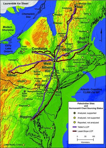
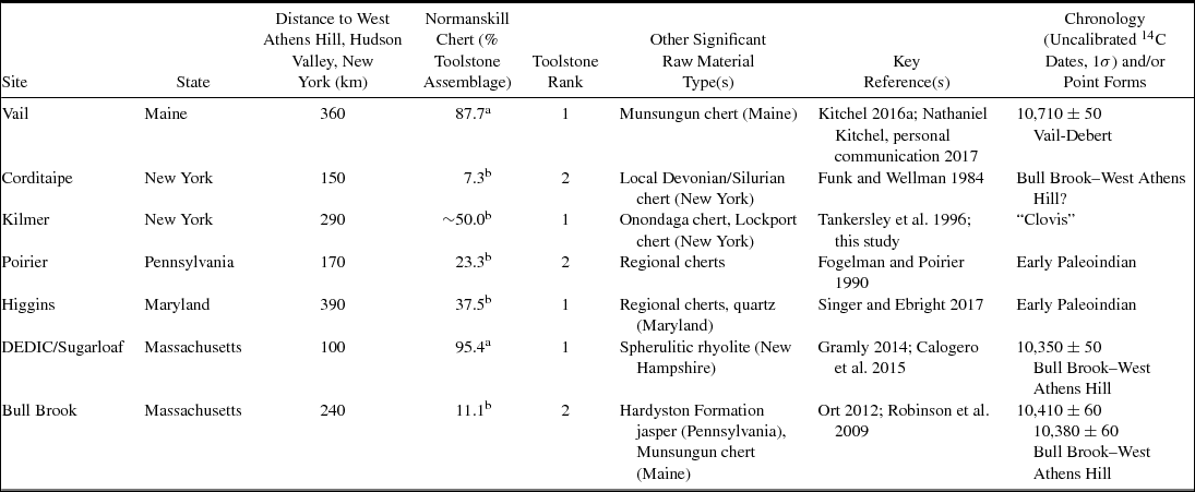
As the basis for this LCP analysis, Figure 5 maps the locations of the 19 sites analyzed and their XRF results. For the LCP study, we chose seven Early Paleoindian sites (ca. 13,000–12,200 cal BP) as destination points located between 100 and 390 km (straight-line distance) from WAH, across diverse terrains. Normanskill chert is the dominant or most common minority toolstone in these seven site assemblages, suggesting direct procurement (Table 2). Based on the sourcing links established by the XRF analysis, we assumed that these sites were outbound waypoints along annual rounds for groups leaving WAH after toolstone acquisition.
Overlay of X-ray fluorescence (XRF) sourcing analysis results for 19 Paleoindian sites and least cost path (LCP) Least-Slope and Tobler's hiking function pathways from West Athens Hill to seven fluted point sites. LGM = Last Glacial Maximum. Note: Positive Normanskill sourcing identifications for sites of Bull Brook (Robinson et al. Reference Robinson, Ort, Eldridge, Burke and Pelletier2009), Mahan (Gauthier and Burke Reference Gauthier and Burke2010) and Templeton (Singer et al. 2019) also depicted.

Toolstone Information for Early Paleoindian Sites Included in Least Cost Path Analysis.

Sources: 14C dates from Lothrop et al. Reference Lothrop, Lowery, Spiess and Ellis2016:Table 3; point forms from Bradley et al. Reference Bradley, Spiess, Boisvert and Boudreau2008.
a Toolstone assemblage made up of tools and debitage.
b Toolstone assemblage made up of tools only (at Higgins site, due to variable vertical distribution, debitage was not included in calculating toolstone proportions).
Along with WAH, these seven sites define a study area in northeastern North America that extends roughly 900 km north-south and 650 km east-west, encompassing the Appalachian Highlands, Piedmont, and Coastal Plain Provinces (Figure 5; Supplemental Figure 1; Thornbury Reference Thornbury1965). Glaciated landscapes make up the northern two-thirds of the study area and include settings of greatest relief and a maximum modern elevation of 1,900 m (6,200 ft). The topographic grain of valleys and mountain ranges is primarily north-south or northeast-southwest. Other prominent features at circa 13,000 cal BP that likely influenced Early Paleoindian seasonal travel include major drainages (Supplemental Figure 1) and the positions of the Laurentide ice sheet in Quebec and Ontario, the Champlain Sea, and the Atlantic coastline on the continental shelf (Figure 5).
LCP analysis requires selection of (1) a cost or friction surface (usually energy or time, based on slope) and (2) a cost-surface vector algorithm to solve for that currency (Herzog Reference Herzog, Bevan and Lake2013:181–183; Kantner Reference Kantner, White and Surface-Evans2012:225–229). The standard approach to creating cost surfaces for LCP analysis relies on slope. Other cost elements can be added, such as rivers and other potential physical barriers, as well as “culturally-encoded costs” (Bevan Reference Bevan, Herrera, Pérez and Simposio2011:385), such as sacred areas or territories that should not be crossed (Chapman Reference Chapman2006:108). Given the potential subjectivity of such additional cost factors, however, Bevan (Reference Bevan, Herrera, Pérez and Simposio2011:385) and Batten (Reference Batten, Clark and Hagemeister2007:170) favor simple cost-surface models, which can then be refined if appropriate (Herzog Reference Herzog, Bevan and Lake2013:205). Given the large size of our study area, and unknowable cultural criteria that may have influenced Paleoindian seasonal travel, we used simple friction surfaces and two vector algorithms, geared to reflect two alternate interpretations of Paleoindian mobility.
A traditional view holds that for Paleoindian peoples in northeastern North America, a highly seasonal resource base fostered a focal subsistence strategy (relying in part on migratory herd prey such as caribou) and extensive range mobility (e.g., Snow Reference Snow1980:136, 150–152). Perhaps reflecting this view, Paleoindian residential sites cluster in low-elevation settings, including major valleys and lowlands (e.g., Chapdelaine Reference Chapdelaine2012). Accordingly, several researchers have inferred that late Pleistocene peoples routinely followed these topographic corridors as pathways of least effort for seasonal travel (e.g., Gramly Reference Gramly, Laub, Miller and Steadman1988:267–270; Lothrop and Bradley Reference Lothrop, Bradley and Chapdelaine2012:28–30).
Others argue that two distinct factors may have conditioned Paleoindian mobility differently in the formerly glaciated Northeast and adjacent Midwest. The first was a subsistence adaptation that routinely targeted widely spaced resource patches (often containing resources that were only seasonally available) while only minimally exploiting resources along the intervening terrain (Ellis Reference Ellis2011:393, 398; Koldehoff and Loebel Reference Koldehoff, Loebel, Adams and Blades2009:282–283). Under conditions of low population density, social concerns such as mate exchange and information sharing probably also encouraged high residential mobility for periodic interaction (Anderson and Gillam Reference Anderson and Gillam2000; Ellis Reference Ellis2008:308–310; MacDonald Reference MacDonald1999; Whallon Reference Whallon2006). Ellis (Reference Ellis2008:309–310) proposes that if northern Paleoindians lacked efficient transportation aids, such high levels of range mobility may have required time management strategies that governed the design and organization of their stone technology. Here, we extend this perspective to aspects of seasonal travel, leading to the notion that Paleoindian groups placed a premium on seasonal routes that minimized travel time between encampments.
We employed two currency/algorithm approaches that reflect these alternate views of Early Paleoindian mobility on the deglaciated landscapes of the Northeast. Assuming that Paleoindians relied on valley and lowland corridors to facilitate travel, our first LCP analysis employed a vector algorithm designed to identify cumulative paths of least slope (i.e., requiring less energy to traverse) from WAH to the seven destination sites (here designated “Least-Slope” pathways). For the second LCP analysis, reflecting the hypothetical importance of time management strategies for highly mobile Paleoindians, we employed the Tobler's “hiking function” algorithm (Tobler Reference Tobler1993) to solve instead for travel time, seeking the fastest pedestrian route between WAH and each site (designated “Tobler's” pathways).
Digital Data and Methods
We used ArcGIS v10.2 for all processing and analyses. US Geological Survey digital elevation model raster files were projected in the North America Lambert Conformal Conic coordinate system, and the Raster Calculator tool was applied to all digital elevation model files to eliminate negative values (Supplemental Text 1). Site locations were digitized in the same coordinate system, with WAH as the origin point.
We developed two sets of cost parameters for two different LCP analyses, the first isotropic and the second anisotropic. In the first analysis, cost was based on degree of slope as a proxy for movement cost, with the algorithm solving for cumulative routes to or from the point of origin using the ArcGIS Cost Distance tool (being isotropic, there was no path variance in either travel direction). In the second analysis, we employed Tobler's hiking function, using both pedestrian travel time and slope, to derive outbound, anisotropic costs to each destination site. This function has been empirically tested and estimates time (in hours) to cross a raster cell based on slope (in degrees) as calculated on a digital elevation model. In ArcGIS, we employed the Path Distance tool to calculate these anisotropic costs, using a customized vertical factor table developed by Tripcevich (Reference Tripcevich2008) from data published by Tobler (Reference Tobler1993; Supplemental Text 1). We then used the resulting rasters as input for the Cost Distance tool to create the second set of estimated LCPs (solving for time). To estimate pedestrian travel times, for Least-Slope routes we assumed 4 km per hour (2.5 mph), while for the Tobler's route solutions, we derived one-hour interval travel contours from an output raster, with the number of contours intersected by the Tobler's pathway determining travel time to the destination site.
We evaluated the likelihood of alternate pathways to each destination site by comparing these routes with archaeological evidence (Herzog Reference Herzog, Bevan and Lake2013:181–182). Specifically, we checked for the presence of other fluted point sites with Normanskill chert artifacts (reported or confirmed) situated within an arbitrary cutoff distance of 20 km from each pathway. Although obviously subject to discovery bias, the presence of other known sites with Normanskill artifacts near these projected pathways suggests long-term geographic trends in Paleoindian transport of this toolstone that help gauge the relative plausibility of these alternate LCP routes.
Results of LCP Analysis
The Least-Slope algorithm identified cumulative pathways of least slope between WAH and the seven sites (Figure 5). These pathways emphasize travel via valleys and lowlands, generally following the regional topographic grain. By contrast, the Tobler's algorithm yielded more direct route solutions to the destination sites, often across high-elevation terrain. While parts of several Tobler pathways do follow natural valley corridors, this usually occurs only when the valley coincides with the overall axis of the route (Figure 5; Supplemental Text 1).
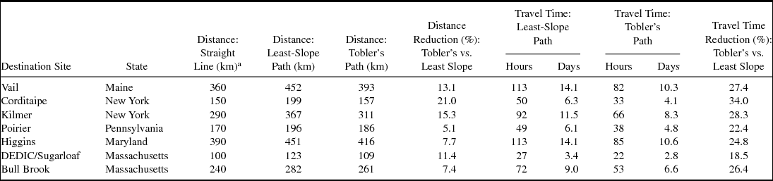
In terms of route length, the Least-Slope paths range from 6.0 to 33.0% longer than arbitrary straight-line distances between source and site, with an average increase in distance of 21.8% (Table 3). The more direct Tobler's routes measure 5.0 to 9.0% longer than straight-line distances and are 5.1 to 21.0% shorter than the Least-Slope routes.
Straight-Line and Least Cost Path Route Distances and Travel Times for Least-Slope and Tobler's Algorithms, from West Athens Hill to Seven Early Paleoindian Sites.

a For site security, straight-line distances are rounded to the nearest 10 km.
For routes to Vail, Corditaipe, Kilmer, and Higgins, the shorter Tobler's path solutions generally transit higher elevations of greater relief compared with the valley-focused, Least-Slope solutions (Figure 6). By contrast, the Least-Slope and Tobler's routes to Poirier, DEDIC, and Bull Brook show fewer differences in relief because these paths traverse landscapes with fewer contrasting route options.
Elevation-distance profiles of Least-Slope and Tobler's hiking function pathways vs. straight-line distance from West Athens Hill to (a) Vail, (b) Corditaipe, (c) Kilmer, (d) Poirier, (e) Higgins, (f) DEDIC/Sugarloaf, and (g) Bull Brook. LCP = least cost path.

Turning to travel time, estimates for Tobler's pathways range from 85 hours/10.6 days to Higgins (416 km) to 22 hours/2.8 days to DEDIC/Sugarloaf (109 km), times that are 18.5 to 34.0% less than estimates for Least-Slope routes (Table 3). However, ethnohistoric data on subarctic pedestrian foragers suggest that both travel time estimates may be too fast for moves involving entire Paleoindian social units. For example, Burch (Reference Burch1991:443) cites eighteenth-century accounts of seasonal moves by extended Chipewyan families (men, women, children, and elders) indicating pedestrian travel averaging 11 to 13 km per day (equating to about one-third the mean speed of the Tobler's travel times on these LCP routes of 38.6 km per day).
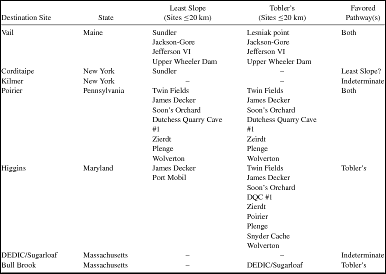
Proximity to other Paleoindian sites with Normanskill chert artifacts along these modeled pathways provides one way to gauge the plausibility of alternate routes to each destination site (Table 4; Supplemental Table 2). Several sites lie near the Least-Slope and Tobler's routes to Vail and Poirier, suggesting that both pathways are equally likely (Figure 5). Conversely, the absence of sites with Normanskill chert artifacts near routes to Kilmer and DEDIC/Sugarloaf implies to us that neither route solution should necessarily be ruled out. For Higgins, the presence of nine sites near the Tobler's path, versus only two sites along the Least-Slope route, favors the Tobler's solution. For Corditaipe, the proximity of one site, Sundler, to the Least-Slope pathway may support this route. For Bull Brook, the location of DEDIC/Sugarloaf only 3 km south of the Tobler's route supports this path to Bull Brook (Supplemental Text 1).
Evaluation of Least-Slope and Tobler's Least Cost Path Routes.

Note: Only sites with Normanskill chert artifacts located within 20 km of pathways are presented in this table; dashes mean no sites present within 20 km of the pathway.
Discussion
The results of this XRF sourcing study are important because they are consistent with provisional identifications of artifacts of Normanskill chert at 15 of the 19 sites analyzed. Although tempered by the small number of samples per site, these findings support impressions from the literature that (1) Normanskill was an important toolstone for Paleoindian peoples in northeastern North America and (2) after acquisition at Hudson Valley outcrops such as WAH, they transported this toolstone widely across the deglaciated Northeast and south of the LGM as well.
For sites where Normanskill chert represents the dominant or first-tier minority toolstone, we view the Normanskill chert sourcing links from WAH to these Paleoindian sites as evidence for outbound travel with this stone after direct procurement. For other sites linked geochemically to WAH where artifacts of Normanskill constitute a very small minority (single-digit percentages or less) of a larger assemblage of tools and debitage, this may instead reflect indirect acquisition through social mechanisms such as shifting band membership or exchange. In such cases, the transfer of Normanskill chert artifacts between groups may have taken place where annual rounds of different bands overlapped.
For the LCP analysis, we selected seven Early Paleoindian sites linked to WAH by XRF results to model intermediate travel routes after toolstone acquisition. We view the resulting outbound paths from this lithic source as route segments of larger annual rounds. Further, because these outbound routes radiate in multiple directions from WAH to distances of up to 452 km, these paths likely represent separate annual rounds of several Early Paleoindian groups that overlapped at the WAH source. Given the potential time depth of these Early Paleoindian sites (ca. 13,000–12,200 cal BP) and contrasting accelerator mass spectrometry dates for some (Table 2), most of these hypothesized annual rounds (as represented by these sites) were likely not contemporaneous.
As expected, the Least-Slope corridors from WAH to the seven sites emphasize valley or lowland routes, while the Tobler's solutions follow shorter transects that include travel across and along higher terrain, routes that fundamentally differ from traditional models of Paleoindian seasonal mobility. Along with reduced travel time, these Tobler's pathways could have offered other advantages for pedestrian travel. First, these more direct paths across uplands would have minimized stream crossings, a likely concern for pedestrian foragers. Second, depending on local forest closure, parts of such upland routes may have afforded strategic viewsheds during transit, perhaps revealing the local presence of large prey such as caribou and other environmental information (Steele and Rockman Reference Steele, Rockman, Rockman and Steele2003:139–140).
Evaluating these alternative pathways from WAH to the seven destination sites based on proximity to other fluted point sites with Normanskill artifacts indicates that neither route solution is consistently favored (Table 4). This suggests that Paleoindian groups in the Northeast may have varied their seasonal path choices, sometimes taking valley-focused travel routes and at other times taking more direct, often upland pathways. Further, the choice of a pathway (and near-term travel strategy) may have been tactical. That is, their route selections could have varied both seasonally and situationally, depending on destination, the character of the intervening terrain, ground and weather conditions, the immediate need to either facilitate or expedite travel, social concerns, and other cultural factors.
Conclusions
Our X-ray fluorescence sourcing results support the notion that Normanskill chert was an important regional toolstone for Paleoindian peoples across the Northeast and that the West Athens Hill outcrop was likely a major source of this stone (Lothrop and Bradley Reference Lothrop, Bradley and Chapdelaine2012). More broadly, based on the provenience of linked sites, these results are consistent with prevailing interpretations of extensive range mobility for the region's Early and Middle Paleoindian populations (Ellis Reference Ellis2011). Notably, the presence of Normanskill chert at the Higgins site suggests that Paleoindians also transported this toolstone south of the Last Glacial Maximum into the Mid-Atlantic, where most sites suggest that reduced residential mobility generally prevailed.
By modeling valley-focused pathways versus fastest routes, the least cost path analysis identified alternate travel paths from WAH to seven Early Paleoindian sites. Most obviously, these LCP results highlight the arbitrary nature of straight-line distances between toolstone sources and sites as proxy measures of Paleoindian mobility. Archaeological evaluation of these LCP route alternates did not consistently favor one algorithm vector over the other, suggesting that northeastern Paleoindians may have situationally adjusted their mobility strategies to either minimize travel effort or reduce travel time. This implication should not be a surprise. Historical accounts and ethnography (e.g., Burch Reference Burch1991; Henriksen Reference Henriksen2009:143–146; Leacock and Rothschild Reference Leacock and Rothschild1994:130–142; Sharp and Sharp Reference Sharp and Sharp2015) highlight the inherent risks of forager lifeways in subarctic landscapes, suggesting that for Paleoindian peoples in northeastern North America, decision-making flexibility for day-to-day travel and seasonal range mobility was one key for survival.
Archaeological evidence suggests that at least some Paleoindian peoples inhabiting the formerly glaciated landscapes of the Northeast often exploited more than one toolstone source during an inferred annual round (Burke Reference Burke, Bressy, Burke, Chalard and Martin2006; Ellis Reference Ellis2011). Paleoindian sites with assemblage evidence for a possible two- or three-source sequence of toolstone acquisition during annual rounds could be used to construct more comprehensive regional LCP-based models of Paleoindian land use and seasonal travel. To the extent that we can discern direct versus indirect acquisition, toolstone types present at trace levels in assemblages could also be incorporated in more comprehensive least-cost models to project possible areas of social interaction between bands.
More broadly, LCP analysis can facilitate examinations of mobility for Paleoindians and other pedestrian foragers in several ways. First, it forces us to reexamine our often long-held assumptions about how these peoples moved across ancient landscapes. Second, compared with straight-line distance data, LCP route modeling offers replicable and likely more realistic projections of human seasonal movement in the past and, hence, potentially more accurate measures of range mobility. Finally, LCP analysis can enhance our understanding of how Paleoindian peoples and other residentially mobile hunter-gatherers interacted with the landscapes they traversed and inhabited during their seasonal travels.
Additionally, optimal path modeling can predict site locations across discrete geomorphic landscapes (Anderson Reference Anderson, White and Surface-Evans2012:241; Rademaker et al. Reference Rademaker, Read, Bromley, White and Surface-Evans2012:33), and such predictions can potentially be ground-truthed with field and collection surveys. For archaeologists, this presents yet another avenue for better understanding human use of ancient landscapes. Of course, optimal pathways only model the optimizing decisions of prehistoric foragers and tell us little about “nonoptimizing” cultural behaviors and decision making. Such behaviors, and their archaeological correlates, are much more difficult to model, but one possible starting point may be to examine the characteristics of sites not associated with optimal pathways.
Acknowledgments
Thanks go to Eric Voigt for inviting us to present this research in the “Breaking Boundaries” session at the 2014 Society for American Archaeology meetings in Austin, Texas, and to Anne Dowd for her discussant comments. We thank those persons who loaned or facilitated access to collections for X-ray fluorescence analysis, including Donna Baron, Dick Boisvert, Joe Diamond, Gary Fogelman, Joe Gingerich, Mike Gramly, Brian Jones, Darrin Lowery, Royce and Jamie Kilmer, Rebecca Morehouse, John Pfeiffer, Richard Poirier, Jess Robinson, Alan and Brad Sanderson, Zac Singer, Art Spiess, Tom Weinman, and Leonard Ziegler. Nathaniel Kitchel (Vail site), Philip LaPorta (Soon's Orchard, Twin Fields), Darrin Lowery (Twilley site), Zac Singer (Templeton, Little Rocky Creek, and Higgins), and Art Spiess (multiple Maine sites) all graciously shared unpublished data on assemblage toolstone profiles. Nicholas Tripcevich kindly provided us with a customized vertical factor table to calculate anisotropic costs for the least cost path analysis. We are grateful to John Hart, Chris Ellis, Hetty Jo Brumbach, Stuart Fiedel, Ryan Parish, and two anonymous reviewers, who commented on drafts of this article, substantially improving its organization and content. Thanks go to Claude Chapdelaine for his assistance with the French abstract. John Hart, director of research and collections, and Director Mark Schaming provided institutional support for this research through the New York State Museum.
Data Availability Statement
We obtained artifacts for X-ray fluorescence sourcing analysis from loaning institutions and individuals listed in Table 1. X-ray fluorescence data are curated by Adrian L. Burke, Département d'Anthropologie, Université de Montréal. Least cost path data are curated by Susan Winchell-Sweeney, research and collections, New York State Museum.
Supplemental Materials
For supplementary material accompanying this article, visit https://doi.org//10.1017/aaq.2018.25.
Supplemental Figure 1. River valleys and mountain ranges in the northeastern North America study area and select toolstone quarries/outcrops.
Supplemental Figure 2. Total alkali-silica (TAS) compositional diagram (Middlemost Reference Middlemost1994), showing the volcanic rock classification for Michaud site artifacts.
Supplemental Text 1. Background to X-ray Fluorescence Sourcing Analysis and Notes on Least Cost Analysis.
Supplemental Table 1. Paleoindian Sites with Reported Artifacts of Normanskill Group Cherts by Drainage Basin.
Supplemental Table 2. Distance Data for Table 4, Listing Closest Distance between Pathways and Nearest Nondestination Paleoindian Sites with Normanskill Chert Artifacts.