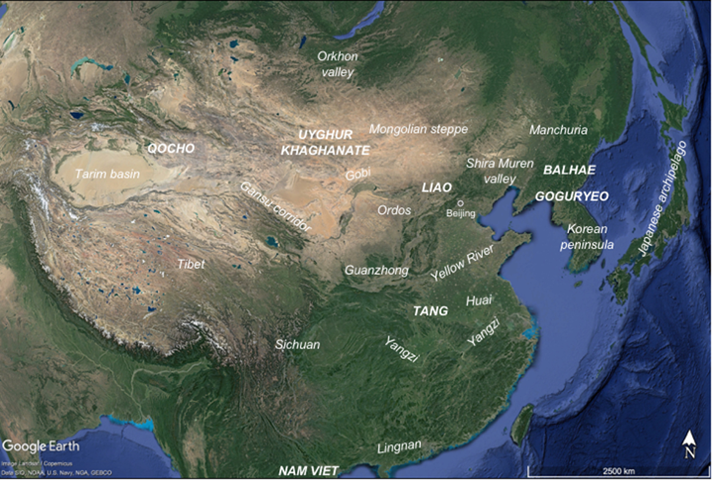


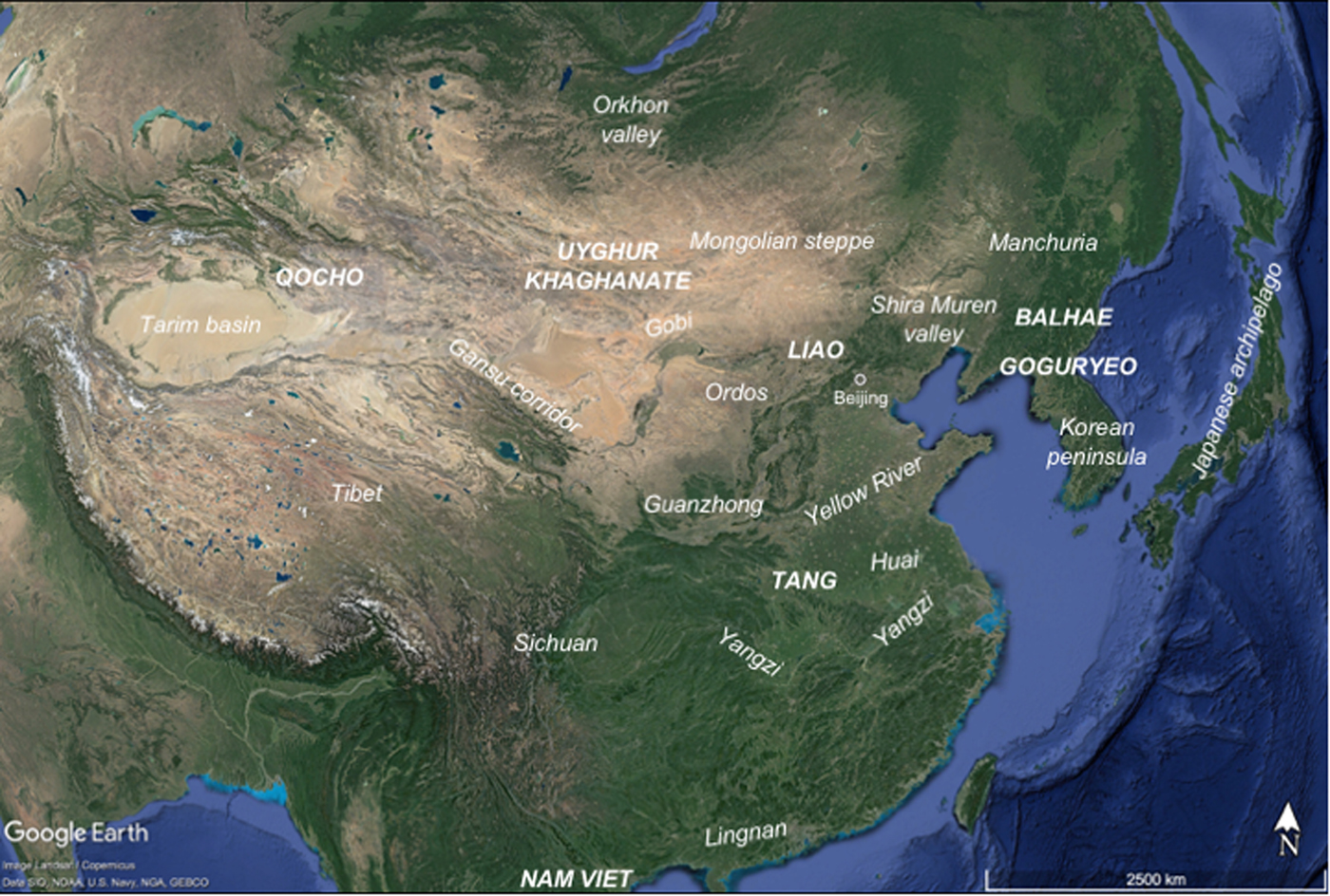
I am currently writing a global history of eastern Eurasia between 600 and 1350, without using the word ‘China’ (Figure 1).Footnote 1 This paper explains why and how, illustrated with a worked example. The thinking here feeds my broader search for methodologies for identifying distinctive characteristics and elements of the global medieval or pre-modern,Footnote 2 to help to challenge claims that ‘there is no alternative’ to teleological modernities such as neoliberal economics, and especially the nation-state. My habitual starting place is a critique of historians’ standard categories, enmeshed as they are in modernity; there are more productive ways of approaching pre-modern histories. Historical writing is always a product of its own time, and as I write, in 2019, there is also an increasing urgency to offer new understandings of the past that speak against the worst instincts of human beings and the ideologies that support those impulses in the present day.Footnote 3 Once freed from standard concepts, pre-modern global histories – worlds before nation-states – are well placed to generate such understandings. Here I argue that there is indeed an alternative to the putative precursors of modern nation-states, and offer a framework for doing without them.
Map of eastern Eurasia showing selected regimes and regions named in the text; the former did not all coexist and the latter are convenient geographical descriptions derived from different historical periods. Image: Standen, based on Google Earth.
I The problem of modern categories in pre-modern contexts
Global history may be usefully distinguished from World History:Footnote 4 standard categories of World History analysis are inadequate for studying pre-modern global histories. Top-down analyses of economics, power, monotheistic religion, identity and above all the nation-state carry assumptions that valorise the pursuit of profit, competition, secularism, ethnicity – and by extension modernity and the West. These categories and assumptions pay little respect to social relations, gender, localities, anything on a human scale, or to the majority of the world. Much World History continues to be variations on the ‘rise of the West’, focused on the implicit inevitability of the rise of modern nation-states from anticipatory versions, traced over the last 500 years.Footnote 5 Challenges have focused on matters such as amending the eurocentricity, periodisation or regional focus of the analysis, and developing more sophisticated comparisons, but have not changed the basic socio-economic or ‘national’ frameworks.Footnote 6
Global history starts from a different place and follows different priorities, seeking connections and patterns in any and all aspects of planetary life, society and environment, encouraging attention to different scales of analysis, from overview to localities or even individuals, and exploring the connections across different scales.Footnote 7 Most importantly, global approaches resist teleology to focus on the historical present, exploring worlds where the future was still unknown, rather than seeking links to modernity.Footnote 8
It is from this perspective that I eschew the word ‘China’. Adopting this as a formal restriction has proved to be highly effective in forcing me to confront habits and shortcuts that I share with many others, and it makes a substantive contribution by forcing a rethink of basics such as the terminology for regions, groups and periods, which in turn requires contemplation of what these labels really mean: what are the specific referents implied by a name that seems solid until we try to define it? The answers to that question are more precisely delineated entities that require further consideration of how to structure the relationships between them, which has generated a layered approach.Footnote 9 In what follows I shall briefly discuss terminology, then explain the framework I am adopting, and illustrate it with a comparative discussion of some Liao 遼 dynasty (907–1125) cities. I hope to persuade you that other ways are possible: that we can discuss pre-modern history without the misleading shorthand of ‘national’ terminology, and that this offers opportunities for fresh insights and lines of enquiry.
Terminology
The first problem is what to call the groups who may be identified in this segment of history. ‘The Chinese’ or ‘the Koreans’ refer to the people claimed by (and indeed claiming) modern states,Footnote 10 and use of these terms by present-day historians for pre-modern contexts implies primordial national status (in the technical sense) for these groups in ways that are denied to, for instance, ‘the Uyghurs’ or ‘the Tibetans’, whose pre-modern states and empires have transmuted into ‘minority ethnic’ status within larger modern entities.Footnote 11 ‘The Türks’ or ‘the Kitan’ no longer exist as groups, and in our sources they are broad etic names that conflate considerable diversity under a convenient label.Footnote 12 We may achieve greater precision by speaking of dynasties and regimes named in our sources, such as the Tang 唐, 618–907 (not ‘the Chinese’), the Uyghur Khaghanate, 740–844 or Qocho 高昌, 850–1209 (not ‘the Uyghurs’), Liao (not ‘the Kitan’), Goguryeo 高句麗, 37 BCE–668 CE or Balhae 渤海, 698–926 (not ‘the Koreans’), Heian 平安, 794–1185 (not ‘the Japanese’). Regimes are more clearly definable in time, including appearance, disappearance and sometimes reappearance, and we can track their changing geographical compositions. These overtly political labels also open necessary questions about who was included in these units.Footnote 13
We also need more clarity about where was included. Using the names of political units to refer to geography implies fixed territorial extent when in fact borders changed continually, and may suggest an unlikely uniformity of circumstances (one favourite concept among historians is ‘control’) across everywhere claimed by a given regime. Focusing on geographical regions encourages greater precision and further helps to break the link with presentist habits. Thus, for example: the Japanese archipelago (not ‘Japan’) and the Korean peninsula (not ‘Korea’). These geographical features (see Figure 1) give us a contrasting mainland, considered as regions of different sizes for different purposes and periods: the Tarim basin, the Mongolian or eastern steppe, the Gobi region, Manchuria, Sichuan, the Gansu corridor, Guanzhong, the Ordos, the Yellow River valley, the Huai–Yangzi region, the middle and lower Yangzi, Lingnan, and so on.Footnote 14 We get a sharper focus, more precision, a more human scale. It becomes easier to remember the local, which reminds us to keep relating the global back to it.
Thirdly: East Asia historians habitually refer to chronological periods in terms of dynasties, which could be several centuries long, like Tang 唐 (618–907) or Goryeo 高麗 (918–1392). Of course, some developments spanned areas larger than one political unit – which dynastic chronology should take priority? – and did not automatically respect dynastic changes. Referring to centuries instead offers neutrality and greater precision.
Technologies
This approach to a pre-modern global eastern Eurasia requires an organising principle that maintains an analytical rejection of the nation-state and instead frames discussion using other groupings and combinations. The structuring possibilities are limited only by the historian's imagination, and here I have chosen the concept of technologies, broadly understood. While my topics have a strongly material inclination, the concern is not so much with specific techniques, such as building watertight bulkheads or rammed-earth construction – although some of these do feature – as with sets of practices that solve particular problems such as how to build an oceangoing ship or a city wall, or indeed how to convey religious ideas, get an heir or train an effective bureaucracy. It is these sets of practices that constitute technologies in this usage.Footnote 15 Here I draw from the section of my project on ‘Technologies of everyday life’, which includes discussion of cities.
Technologies suit my purpose because they place human agency front and centre. People do not adopt ways of doing things just because they are or become available, or because they are the best solution for a given problem. New situations require methods for addressing new challenges. Where a method is already in place, people need reasons to change from what they already do. The adoption, modification, rejection or abandonment of any given technology always involves agency, and often on the part of anonymous ordinary people in everyday life.Footnote 16 Technologies thus assist in the quest to extend the scope of pre-modern studies beyond the elites, often genealogically associated with modern nation-states, who have dominated both textual and material sources. I would emphasise, however, that technologies are simply one among many potentially useful approaches to global history, and as the field expands, I would hope to see many analytical structures coexisting.
If I am to avoid a history consisting of merely a set of descriptions of Things People Did, then I must reassemble my discussion of technologies into some kind of larger pattern or set of patterns. Having rejected the blocks represented by ostensibly ethnopolitical units, I have opted instead for layers, which allow us to pursue specific technologies wherever they may be found, without regard for extraneous barriers.
A relatively small number of technologies become embedded as practices that undergird the everyday life of all or virtually all the people in all social strata in a given region, such that removal or abandonment of those practices would fundamentally alter the substance of life in those areas. I call such foundational technologies substrates, and we may think of other everyday practices as being rooted in them. Considering religions as technologies, for example, we see that Mahayana Buddhism was by 600 a substrate across the whole of eastern Eurasia, having been embraced in the guise of one sect or another by at least a large proportion of all levels of society in almost every region from the Tarim to the Japanese archipelago, and making indelible material impacts through rock carving, proliferation of the new architectural form of the pagoda, and treatment of the dead, as well as permanent incorporation of concepts such as nirvana and merit-making into beliefs and everyday practices. The absence of this layer would have made eastern Eurasia a very different place.Footnote 17 As we shall see, basic construction techniques formed another substrate that spanned the whole region, though the geographical range of these methods was not completely coterminous with the extent of Buddhism. The limits attained by each layer of technology cannot be presumed to align, but must be traced separately.
Most technologies do not form substrates. Textiles, for example, were essential to the functioning of societies but did not structure those societies as Buddhism did. Textiles were indispensable for clothing, but had many other uses that they shared with other items. Silk was produced in very large quantities, and was used as tax payment, money, religious offering and status marker, among other things, in each of which uses it could be joined or substituted by other items such as grain, silver, votive objects, or tallies marking rank. Unlike Buddhism, if silk had disappeared its place could have been taken by other options without generating permanent rearrangement of the fundamentals of life.Footnote 18 Analytically, each use for each item forms its own layer.
Technologies may occur in specific locations or among specific groups that form discrete nodes, a more familiar concept, including examples such as silk workshops or storehouses, specific urban sites such as those discussed below, or indeed, individual Buddhist temples, rock-carving sites or pagodas. Each set of nodes of a particular type creates a layer that overlays the broader substrate. And each individual node is usually a place where a number of different layers interact with greater intensity.
Those interacting layers may also include networks created by specific technologies, which often have nodes but do not require them. While we may sometimes wish to consider nodes of silk production and storage, scholarship thus far has paid more attention to flows of silk through economic, political and religious links, emphasising the connecting role of these textiles rather than the nodes between which the silk travelled.Footnote 19 By contrast, in a chain of fortifications the individual nodes may well be deemed of crucial importance, since the overall effect depends on the presence of each element. In cases like this the nodes and the network are interdependent. Many technologies will be amenable to both nodal and networked analysis, with each forming its own layer, though one may be emphasised over the other in any given project or discussion.
The three types of layer – substrates, nodes and networks – coexist and interact. As noted above, different substrates are not automatically coterminous either spatially or chronologically. Each of many networks underwent numerous changes, which included appearing, intensifying, thinning, moving, evolving, reconfiguring and disappearing, among others. We may trace different shapes and extents depending on the technology in question and the timing. Nodes each have their own chronology too, and may be stationary but do not have to be; examples of moving nodes include armies on campaign, peripatetic courts or cities rebuilt near but not on top of an earlier site, or transferring the name and functions of an administrative unit to a new geographical location. If we imagine a set of layers, with each technology often providing more than one stratum of different types, then the connections between different technologies are made by looking down vertically through the filo sheets, where the everyday life of a city is shaped by, for example, its Buddhist temples, the activities of its clergy and the worship by its citizens, by the activities of officials met with compliance or resistance, by flows of trade goods that are produced, pass through or are consumed there, and by the armies defending or besieging its walls.Footnote 20
In its concern for interlocking specificities this is fundamentally a microhistorical approach that accordingly does not lend itself to the kind of generalisation usual in short regional histories spanning many centuries. Instead I undertake case studies of specific technologies in specific subregions in specified sub-periods, seeking spatialised patterns but mostly not attempting to provide narrative arcs. This may lead to a weak sense of change over time, although I do address this within certain topics. Instead the focus is on a selection of longer or shorter historical moments, which may deny the reader the satisfaction of the overall story expected from a historian, but finds an analogue in the methods of archaeologists, who tend to see themselves as providing snapshots of general moments in the past as pieces towards an incomplete and ever evolving jigsaw. The absence of a unifying narrative staves off over-generalisation but does not obviate arguments or conclusions.
The most necessary outcome of this approach is that political units become a function of interactions between a number of layers of activity, rather than the pre-existing containers for everything else. By separating out political units from technologies – that is, seeing political units as a manifestation of technologies of politics, or as results arising from intersections of several technologies – we may disrupt the ‘methodological nationalism’Footnote 21 that all too easily assumes political units as the basic building blocks; that cultural, social, economic and other boundaries all align to a significant degree with political borders; and that this is as it should be. When we see culture, social entities and economics, along with politics, religion, gender and the rest, as technologies or the manifestations of technologies, we have a framework that can take us beyond the merely transnational – where the national remains fundamental to the conceptualisation – to possibilities for presenting not only specific but also more general histories without reliance on the framework provided by political units.
II Eastern Eurasian urban centres
This is all very well, but our ability to globalise eastern Eurasia in this way may be deflected before we even start by the predominance of materials about ‘China’ in the surviving sources, and in the resulting modern scholarship, which is only now beginning, sometimes, to locate analysis in global context.Footnote 22 Explicitly or implicitly, researchers have all too often followed the sinocentrism of their sources to narrate the inexorable progression of pre-modern ‘Chinese’ dynasties towards the modern nation-state of China, both of which shower civilisation on the surrounding barbarians in a colonisation of historiography visible then and now.Footnote 23 I believe it is important to disrupt the normativity and dominance of ‘China’ in the region both in historical study and in the present day, and to that end my project seeks its case studies from specific locations scattered across the whole of the broader region. Thus, for instance, I consider padi rice production in the Japanese archipelago and the examination system in the Korean peninsula, and here I explore city forms in the Liao dynasty based in present-day Inner Mongolia. The approach through technologies, often evidenced to a significant degree by material remains, offers a fine opportunity to grant agency to people deemed ‘peripheral’ in the usual sinocentric approach, and thereby to make them central in their own story. In the case of the Liao, this work hopes to diversify perceptions of both ‘nomads’ and ‘cities’ in eastern Eurasia beyond the assumptions that nomads did not have cities and – since that assumption is clearly false – that those they did have followed models borrowed from ‘China’. I will use primarily archaeological evidence for a topic for which there are few textual sources.Footnote 24
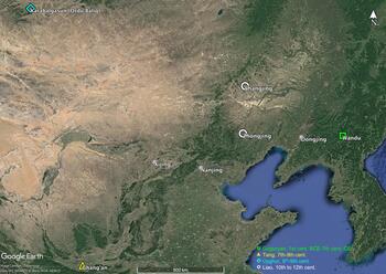
The Liao were a northern dynasty founded by two intermarrying clans of agropastoralists based in the Shira Muren valley in what is now south-eastern Inner Mongolia.Footnote 25 Commonly labelled as ‘pastoral nomads’ defined by their mobility, and sharply contrasted with the sedentary agricultural ‘Chinese’ and their network of cities, the Liao have not received enough attention for their own rather extensive use of urban centres: some 200 at a recent count.Footnote 26 Here I offer three comparisons, each pairing a Liao site with one from a neighbouring area, each of which is typically taken to represent a different cultural zone, although I shall not be discussing them in these terms but rather to counter this conceptualisation (Figure 2). The goal here is not to try to trace linear connections or ‘influence’ (a deeply problematical term), but to explore the Liao uses in their cities of specific elements that we may conceive as having been drawn from a pool of available possibilities.Footnote 27 The resulting accumulation of diversity sets in question the habitual quasi-national conceptualisation of the Liao.
Map showing the five Liao capitals and three comparator capitals. Image: Standen, based on Google Earth.

For the whole of eastern Eurasia, from the eastern Tarim to the Japanese archipelago and from Mongolia to Lingnan, scholarship has posited a model form of the city which, like so many other things, has been said to stem from the Yellow River empires. Within this model, the key diagnostic feature of a city was its wall, or rather its walls, to the extent that the same character, cheng 城, was used for both the city and at least the outer and main dividing walls.Footnote 28 Within those divisions there were further walls around wards, and walls around residential compounds and major buildings. All of these walls were typically built of rammed earth dug from the surrounding land. This method produced a surprisingly hard and strong structure, which after centuries of weathering may survive to several metres in height. Stone or fired brick were generally used only in specific locations: gates, defences, paving for roads or major buildings, column bases, and certain types of building such as pagodas. Important buildings had roofs of heavy ceramic tiles, glazed for structures of the highest status. Columns, beams, thresholds, complex dougong bracketing systems to bear the weight of the roof, non-structural infill between columns, temporary forms for making rammed-earth buildings, and internal strengthening lattices for city walls were all made of wood.Footnote 29 All of these features may be found at one Liao urban site or another, but these are not the only elements visible.
Turning to the texts, capital sites form the top layer described in SiniticFootnote 30 administrative geographies – for the Liao as for other dynasties – that commonly present a neatly hierarchical system of capitals controlling prefectures controlling counties, each governed from an administrative seat that was a smaller version of the one at the level above.Footnote 31 Similarity of form easily implies similarity of function across different regimes and geographies and centuries, but in fact there was a much wider range of both form and function.Footnote 32 Here I will take the Liao as my focus, placing urban settlements associated with the dynasty within their broader landscapes, to seek a more expansive and plural view.
III Tang Chang'an 長安 (618–904) and Liao Zhongjing 中京 (1007–c. 14th cent.)
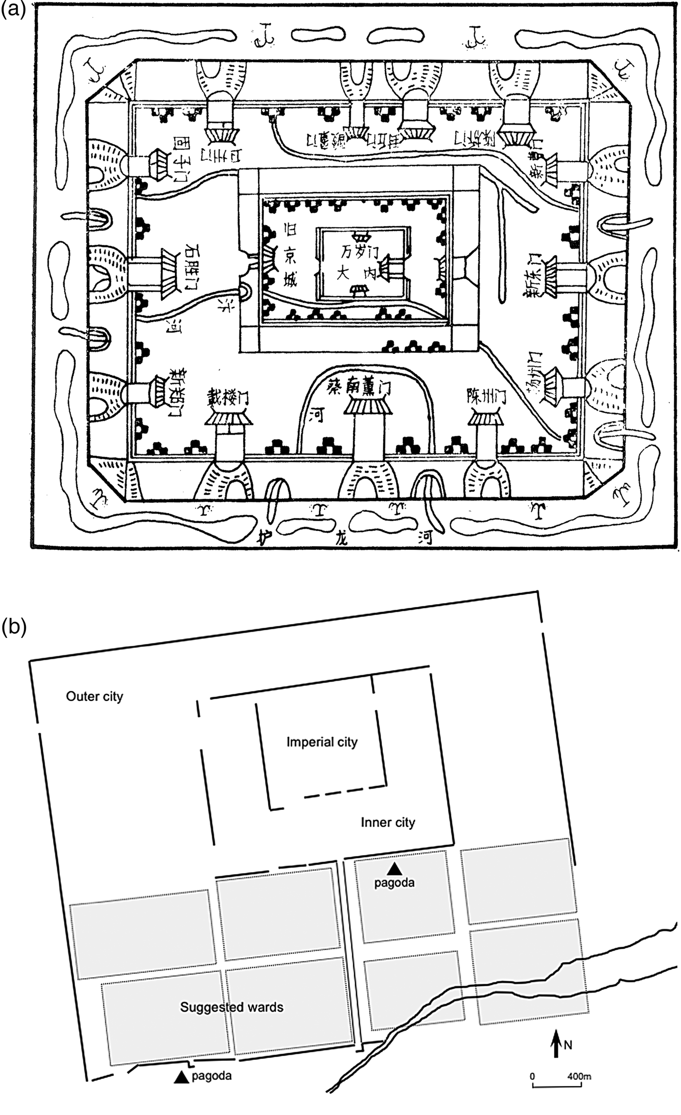
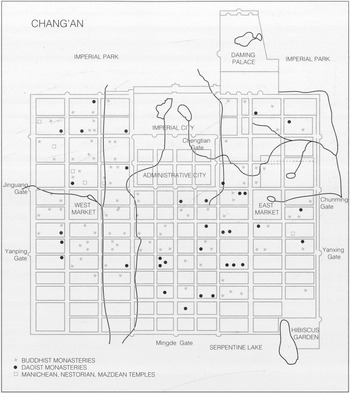
In the Sinitic tradition the classic city was imaginary: a capital planned as a walled square orientated to the north, with orthogonal streets running to multiple gates. The ruler's palace complex 宮城 (gongcheng), also walled, was positioned centrally and there were markets to the north and altars to the east and west.Footnote 33 The city plan reflected the cosmological ideal of order, and building according to this model contributed to a ruler's legitimation. But in fact, no real city actually looked like this, even though they were often drawn as if they did, as illustrated in Figure 3a.Footnote 34 Tang Chang'an is commonly taken as representative of the classic model in practice. The Tang capital was planned and constructed as a square facing north, divided by a central avenue 155 m wide and other orthogonal main streets running to numerous gates (Figure 4). Tang ideology and practice conceived cities at all levels primarily as administrative centres, established by imperial fiat to house government offices, ritual locations, permanent markets, and troops, in buildings that, except for the gates and bell or drum towers, rarely exceeded two levels. Commoner dwellings and workshops, largely single-storey, occupied the grid of wards in the Outer City 外城 (waicheng).
(a) Idealised plan of Bianliang (Kaifeng) alongside (b) archaeological plan of Liao Zhongjing. Images: (a) From Dong Jianhong 董鑒泓 et al., Zhongguo chengshi jianshe shi 中國城市建設史 (Beijing: Zhongguo jianzhu gongye chubanshe, 1982), p. 42. With thanks to Nancy Steinhardt. (b) Standen after Gwen Bennett, based on Google Earth. Original composite courtesy of Lance Pursey.

Plan of Tang Chang'an. Image: from Patricia Ebrey, Cambridge Illustrated History of China (Cambridge, Cambridge University Press, 1996), p. 117. With kind permission of Cambridge University Press.

These practical developments still fitted the classic model, but in several areas supposedly archetypal Chang'an strayed from the ideal. The classic model placed the ruler at the very centre both physically and cosmologically.Footnote 35 At Chang'an the officials’ Inner City 內城 (neicheng) and the court's Imperial City 皇城 (huangcheng) instead formed two halves of a square on the northern outer wall, their enclosures neither square nor central, while the emperor's palace complex formed an extension protruding to the north, and surrounded by a huge hunting park. Most visibly, there were a number of tall pagodas scattered around the city in conjunction with Buddhist temples, following no particular pattern.Footnote 36 The pagodas towering above an overwhelmingly low-level built environment were a constant physical reminder that Buddhism stood outside the orthodox cosmology.Footnote 37 If not Chang'an, then where could possibly conform to the model? So rather than speaking of ‘variations’ from a classic plan,Footnote 38 I invite you instead to take pleasure in diversity, through the lens offered by the material analysis of three Liao cities and three comparators.Footnote 39
Tang emperors used two capitals for much of the dynasty,Footnote 40 while the Liao by the mid-eleventh century had five (see Figure 2).Footnote 41 The Liao Central Capital, Zhongjing, was founded late, in 1007, on the flat northern bank of the Laoha River 老哈河 ‘where of old the imperial tent of the kings of Xi 系 stood’, and which had been used for both pasturage and agriculture.Footnote 42 As at Chang'an, the ground plan does not follow the concentric ideal. Zhongjing was a nearly square walled site more than 15 km around (Figure 3b),Footnote 43 with a central avenue 64 m wide, lined with stone channels for water and pillared corridors typical of markets.Footnote 44 Unlike at Chang'an, the inner and imperial cities are nested and do not abut the outer wall, which would bring them closer to the ideal but for their location in the north-central part of the plan. A founding story claims that the city was planned and constructed as a single coherent project.Footnote 45 However, excavation revealed several stages of building and rebuilding.Footnote 46 While Tang Chang'an was filled with walled wards that survive well archaeologically, within the walls of Zhongjing there are some fairly regular wards but also large areas that lack building foundations, which may have been for horticulture or may reflect textual accounts of seasonal occupation by the ‘tent cities’ of the emperor's entourage.Footnote 47 At the other extreme, Zhongjing contains the largest extant Liao pagoda.Footnote 48
The classic model features markets but not the production sites that feature heavily in the archaeology at Zhongjing and other urban sites. At Zhongjing, buildings for boneworking reflect the ready access to animals from nearby pastures, while deposits of metal – probably slag or other production debris – 1–2 m thick may suggest weapons manufacturing, and agricultural tools have been found. The texts place a granary in the south-west corner, where a half-metre layer of burned grain was found.Footnote 49 In the hills to the west are brick and tile kilns ranging over a kilometre, which was probably just one of the extramural production centres needed for everyday goods.Footnote 50 If we want to suppose that the plans for parts of the city were derived from a Central Plains model, the extensive modifications suggest that, as we have seen at Chang'an, this design did not fulfil all the needs of the Liao rulers, and certainly not of the commoners without whom the city could not function. As we shall see, Liao city-builders may also have appropriated – and diverged from – other sources of inspiration, and the resulting variety makes it difficult to identify any standard city form that might be labelled as ‘Liao’.
IV Liao Shangjing 上京 (918–c. 12th cent.) and Ordu Baliq (744–840)
It is important to place urban sites within their broader landscapes. The first Liao capital was the Supreme Capital or Shangjing, built in 918 with rivers on three sides in the heartland of the Liao imperial clan, just 270 km north of Zhongjing, but in a quite different environment, and with a dissimilar plan. The region around Shangjing contained the ruling elite's best pastureland, and would have been grazed regularly by the flocks and herds of clan members. The initial building of the capital was managed, and possibly designed, by a notable migrant who came to Liao from an autonomous borderland province just before the end of the Tang, whose education and early administrative–military postings would have made him familiar with ideal city plans and practical building methods. The work was apparently completed in 100 days, and the walls were extended and palace buildings constructed in 926.Footnote 51
Shangjing appears to have been built in conjunction with the settlement nearby of tens of thousands of people captured in Liao raids and warfare, as part of a wider process that involved ‘causing each one to have a spouse, and to bring wasteland and abandoned fields under cultivation’ to supply additional grain, fruit and vegetables to supplement the meat, fish and gathered plants typical of pastoralist diets; and to provide tax revenue.Footnote 52 The supply needs of capitals must have been a known concern, especially to officials, highlighted by the increasingly desperate and expensive responses generated by the degradation of Tang Chang'an's hinterland from the seventh century, and its abandonment as a metropolitan centre in the late ninth century.Footnote 53 For their part, Liao rulers had been transporting huge populations to farm in the northern borderlands for two decades before Shangjing was begun, and latterly receiving refugees from collapsing regimes,Footnote 54 so it is hard to know whether the capital was built to manage the people or the populations were transported to supply the capital. Most likely there was a useful and necessary conjunction. We do not know exactly where these imported farmers lived, but both their communities and the city itself would have reduced the pastureland available, and we must therefore reflect on the impact of new urban sites on the wealth of imperial clan members and probably the livelihoods of the actual herders.
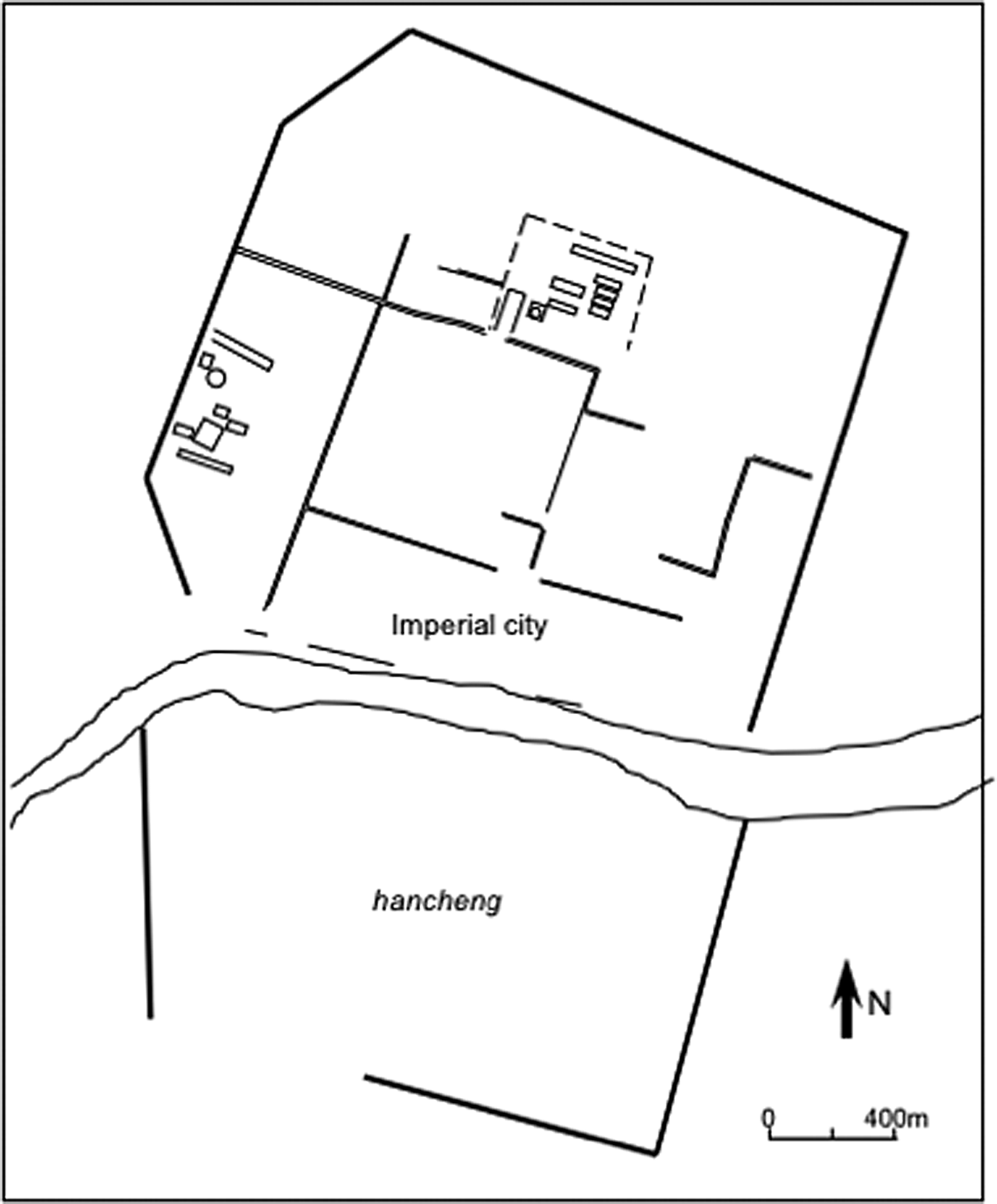
Shangjing was designed as a dual city (see Figure 5), comprising what is usually described as an Imperial City to the north, and to the south a hancheng 漢城, usually translated as ‘Chinese City’, although the archaeology does not allow us to ascribe the inhabitants’ ethnicity, and they are better defined as commoners.Footnote 55 A hancheng was a feature of a good proportion of known Liao urban centres, but was not found in Tang cities. Shangjing is orientated towards the north-east, and both parts are irregular polygons within an outer wall totalling nearly 9 km long. The two sections are divided by the river that would have watered the city and surrounding lands, but may have been prone to flooding then as it has been since.Footnote 56 The walls are of rammed earth and include defensive features such as mamian 馬面 bastions, which are common on fortified walls across eastern Eurasia. The Imperial City had many streets, but no central avenue or systematic grid of wards.Footnote 57 There are 3.5 m of cultural layers, including tiled floors, rammed-earth foundation platforms, stone tortoises which supported stelae, and stone column bases, all of which indicate high-status buildings and long occupation in the many places where they are found across our region.Footnote 58 A palace complex lies centrally in the Imperial City,Footnote 59 which also includes a large area probably for a ‘tent city’.Footnote 60 The hancheng contains concentrations of bricks and tiles, suggesting large buildings, as well as a dense scatter of potsherds and other artefacts that indicate intensive habitation, although there is no other evidence, such as flues for stoves, of large-scale residential occupation.Footnote 61 In the hancheng there were workshops for oil, iron and harnesses,Footnote 62 and kilns inside the city and in the mountains outside produced bricks, tiles, everyday pottery and high-quality wares to supply the city and perhaps beyond. Many stone grindstones and mortars indicate that a lot of wheat and other grains was being ground for flour-based foodstuffs.Footnote 63 There were pagodas within and outside the walls.
Plan of Liao Shangjing. Image: Standen, based on Google Earth, with thanks to Gwen Bennett and Lin Hu.

Rather than seeing the central location of the palace complex and the familiar building methods at Liao Shangjing as necessarily imitating a Tang-style capital, we might instead pay more heed to what was being produced and consumed within and around the walls, identify the networks to which the city contributed and consider why this city might have been built at all. Shangjing was established by a new emperor from a primarily pastoralist background who had long experience, both among his group and personally, of the neighbouring Tang world and its ubiquitous urban centres. The new capital was built under the direction of lowly non-aristocratic officials from that world, one of whom was still in his thirties when he gave general encouragement to the building of city walls.Footnote 64 The central roles of these officials in city-building reflect flows of know-how that readily crossed eastern Eurasian borders and boundaries formed by politics, language, social status and ethnicity. Departures and returns, fresh arrivals, and evidence for continuing cross-border contact suggest that the movements of those with expertise in governance were not one-offs, but passed through and helped to constitute ongoing networks of knowledge and personnel.Footnote 65 These networks of interactions and relationships between individuals shared some elements – nodes formed by specific urban centres – with the formal networks of cities created by the administrative geographies of more than one political unit. But cities were just one element in intangible networks, which were also of different shapes than the pattern of administrative centres, and extended where they would regardless of jurisdiction. The knowledge and connections present in these networks could be drawn upon by anyone with the capacity and desire to employ network members.
Despite the Tang models familiar to the Liao founder and Shangjing's designers, the urban settlement that resulted from interactions within these intangible networks did not follow the plan of a Tang city such as Chang'an, even though Shangjing's functions appear to have included the same administrative and ritual activities. Shangjing's wider landscape included both agricultural and pastoral producers, as well as additional manufacturing for everyday needs, all presumably governed by authorities based in the city.Footnote 66 For each of these activities the city formed one node in a distinctive network variously involving production, supply of raw materials, transportation, taxation, imports and exports, any of which could extend a specific network well beyond the city's hinterland. Such networks required skills and knowledge that may have been confined to a particular category of worker – notably but by no means exclusively officials – but were not restricted to any one political or cultural group. The capital also seems to have had an important role as a place for periodic gatherings by people who brought their accommodation with them, implying that it was a political centre too, and it may have had some kind of legitimating function with those people and with envoys visiting from other realms.Footnote 67 Each different set of political actors placed Shangjing in yet another network that involved a distinctive set of elements and reached its own extent. Shangjing consisted of many aspects, many of them beyond the walls, reflecting a larger range of functions than the classic city represented – though no more embodied – by Tang Chang'an.Footnote 68 Each city was constructed to meet a particular set of needs.
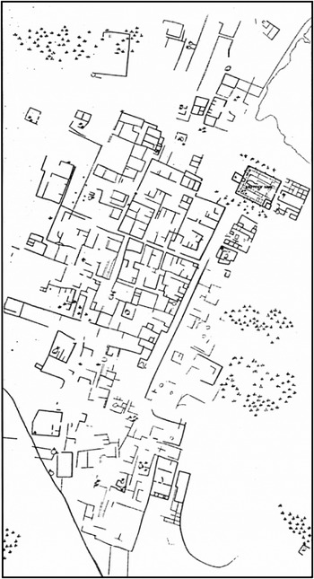
The rulers of the Uyghur Khaghanate (744–840)Footnote 69 built numerous walled settlements in Mongolia, but before the advent of aerial photography, remote sensing, and the money to deploy these methods, these sites were hard to locate.Footnote 70 By contrast, the palace at the Khaghanate's capital of Ordu Baliq, begun in the later 750s and also known at times as Karabalgasun or Kharbalgas, has surviving walls at heights that make it easy to see from far away across the broad valley bottom around the Orkhon, in which numerous other cities were also built at different times over many centuries.Footnote 71 The palace complex is orientated almost east–west and outside each of the longer walls is a line of stupa mounds – a rare feature (see Figure 6). The complex includes a square inner wall, outside the eastern gate of which is a broad avenue flanked by a grid of compounds and buildings. However, this is only a fraction of the area covered by the ruins which, at 7 × 2.5 km, form the largest pre-modern urban settlement in Mongolia.Footnote 72 The designers are said to have been Sogdians,Footnote 73 but their role seems to have been limited to the palace complex, which is the one regular rectangle, located in the north-east corner alongside generally organic clusters of small buildings and walled spaces. The largest of the walled clusters, about three times the size of the palace, is an irregular square containing densely packed buildings.Footnote 74 Stone column bases and heavy fired bricks are among the common building methods that help to distinguish administrative from residential and manufacturing areas, there is plenty of space for the markets mentioned in the texts, and some of the ceramics feature distinctive decorations.Footnote 75
Plan of Ordu Baliq, with the palace complex towards the top right corner. Image: from V. V. Radlov, Atlas drevnostei Mongolii, vyp. 2. Trudy Orkhonskoi ekspeditsii. Sanktpeterburg: Tipografiia Imperatorskoi akademii nauk, 1893, plate XXVII/1, with deep thanks to Daniel C. Waugh.

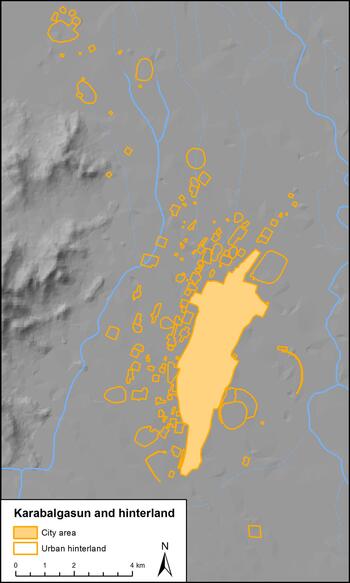
The city lay in a predominantly pastoralist landscape, but an envoy of the Abbasid caliph in 821 described ‘a great town, rich in agriculture and surrounded by districts full of cultivation and villages lying close together’.Footnote 76 Recent archaeology confirms the envoy's report, adding that these districts were all enclosed, in a mixture of square and oval shapes (see Figure 7).Footnote 77 The squares contain potsherds, and roof tiles with the semicircular section found from the Korean peninsula to the Tarim basin, suggesting farming households of men, women and children, dating between the end of the seventh and the mid-ninth century. Biomarkers imply that domesticated animals like pigs or dogs were kept inside the square walls, and an abundance of butchered and burnt bones were found in one surrounding ditch, together with ceramics. A surface-collection survey of one of the ovals found no artefacts, while biomarkers for herbivore faeces were uniformly abundant both within and outside the walls, indicating that herds were not restricted inside them. The biomarkers show that this oval was not an animal corral but probably for horticulture.Footnote 78 The archaeology gives us a view of primary producers providing meat, vegetables and related products, allowing herbivores into their oval horticulture enclosures for fertilisation but then shutting them out during the growing season, when herds would move to summer pastures. Whereas for the time of Shangjing's construction we have abundant textual evidence that the Liao emperors’ revenue was at least coming to rely on agricultural taxation requiring a city-based bureaucracy, at Ordu Baliq we lack any such surviving evidence, so we may be a little more confident that for the Uyghur khaghans the capital came first and its farmers were moved into or settled upon this landscape for the purpose of supporting the city.Footnote 79 Certainly we cannot be sure that the settlements around each of these cities were for wholly the same purposes.
Walled enclosures around Ordu Baliq. Image: courtesy of Susanne Reichert.

Elements of the urban landscape of Ordu Baliq, including the hinterland together with the concentration of buildings around the palace, bore family resemblances to parts of another Uyghur town that seems to have begun in the seventh century and was reused by the Liao, probably in the tenth or eleventh century, with few changes.Footnote 80 We may therefore suppose that members of the Liao ruling group were familiar with these options too. The same archaeological techniques used at Ordu Baliq would be needed to test whether Liao Shangjing, 1400 km away, had similar provisioning arrangements, but we should not be surprised at the Liao appropriating different elements from their diverse predecessors in different locations, any more than we should be surprised by the much wider prevalence of relatively simple and quick construction methods such as rammed earth.
The cities discussed so far were in reasonably flat sites in river valleys and, except for Chang'an, with little or no prior permanent habitation. Such environments lent themselves to fulfilling any desire there might have been for building planned cities to a cosmologically significant design, but as we have seen, it was rare for Liao, other ‘steppe cities’, and even Tang Chang'an, to follow ritual prescriptions in preference to building according to their needs, which included different combinations of administration, politics, display, subsistence, manufacturing, exchange and legitimation. The result was cities that shared little but the basic building techniques of rammed-earth walls within walls, usually polygonal shapes, gates, and pillared major buildings placed in clusters, constructed to an intial plan but subject to later modification. These broadest of similarities formed a substrate of construction methods that spanned eastern Eurasia, and no meaningful claim can be made that they ‘belonged’ to any one group rather than another or that they could accordingly ‘influence’ others. They were simply how you did construction across this whole region, and were subject to pretty much infinite local variation; diversity was the norm.
V Zuzhou 祖州 (bef. 926–12th cent.) and WanduFootnote 81 丸都 (209–c. 7th cent?)
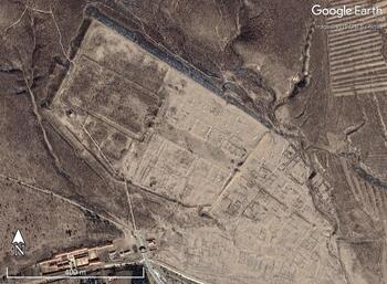
Scholars of pre-modern urbanism in the Korean peninsula often categorise their cities into mountain and flatland types, and the Liao and others also made use of ‘mountain cities’ 山城 (shancheng). Here we find that although some activities overlap with those of urban centres in broad valleys, a distinctive function of some mountain cities, in different locations and under different governing regimes, was burial and memorialisation. The Liao founder's tomb, Zuling 祖陵, was built after his death and is concealed inside one spur running down from a horseshoe of steep-sided, wooded mountains 20 km south-west of Liao Shangjing.Footnote 82 The accompanying city of Zuzhou does not lie in the flat valley bottom that opens out below the mountain defile, but clings to the first sufficiently flat spot on the lower slopes of the eastern side (Figure 8). Although the outer wall of the main city is nearly rectangular (approx. 600 × 300 m), conforming to the landscape has created a pentagon orientated towards the north-west, housing the officials who performed the regular rituals for the imperial dead, and a dense crowd of households, probably attached to a military unit.Footnote 83 As usual, all the walls are of rammed earth, including a narrow rectangular enclosure at the west end, opening onto a wide avenue.Footnote 84 This inner city contains buildings identified by their column bases as ritual halls, some of which are named in the Liao shi 遼史.Footnote 85 Zuzhou itself is named as the autumn location of the emperor's travelling court, but any space for a ‘tent city’ appears to be small, and there is little space to camp outside the walls either.
Aerial photograph of Zuzhou, showing location and plan. Image: Google Earth.

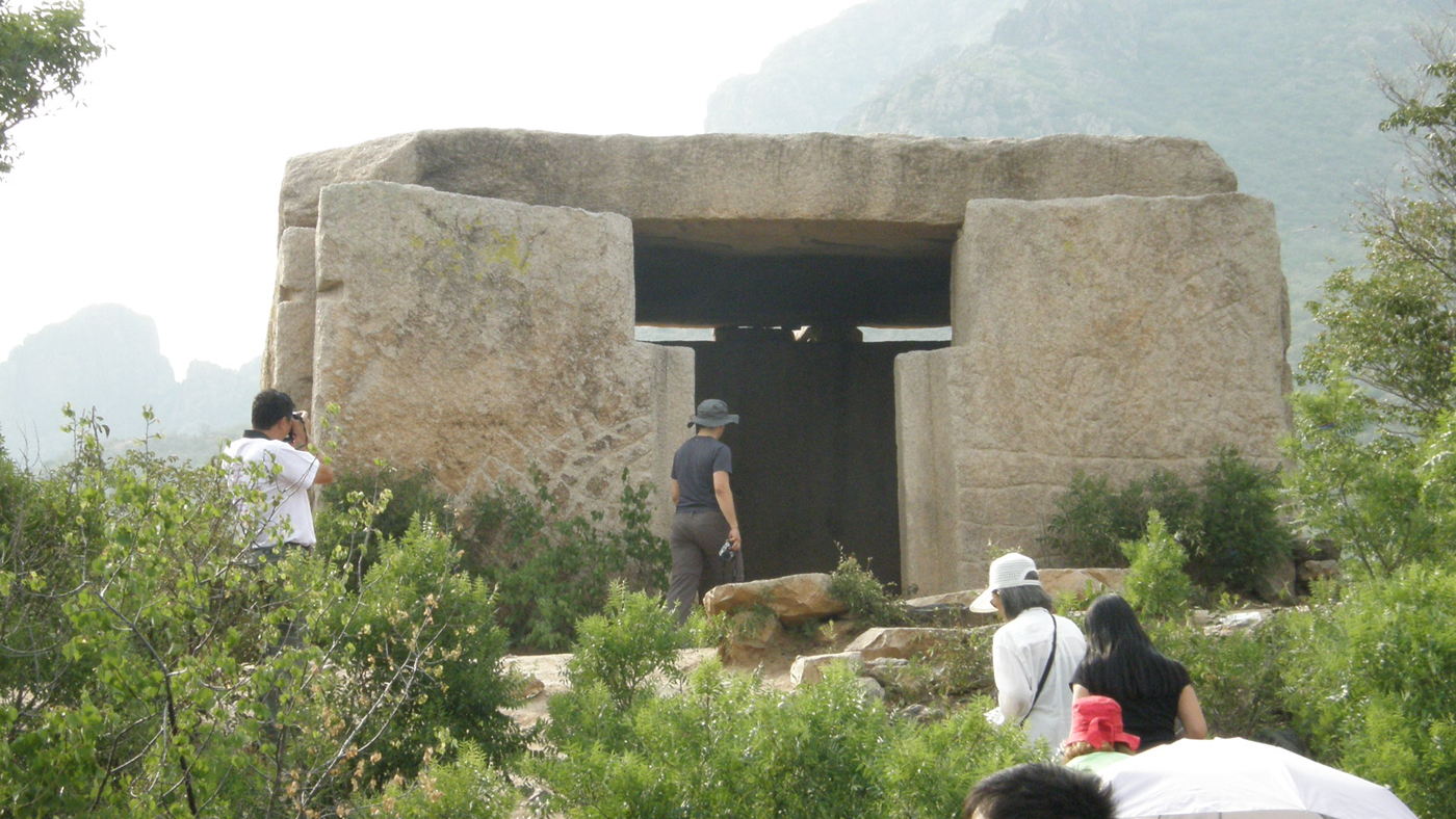
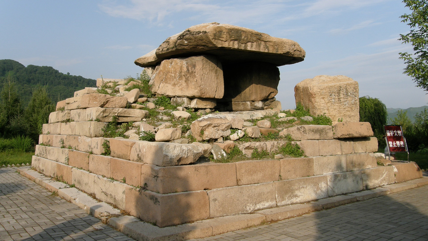
Most curiously, on a rise in the north-western corner of the main city is a structure known simply as the Stone House 石室 (shishi) (Figure 9), built of seven massive stone slabs with the corners originally connected by iron brackets, leaving a T-shaped opening that looks south-east along the same line as the city.Footnote 86 The function of this structure remains a mystery.Footnote 87 If it was already there when the city was constructed then the walls were built around it, and in the unlikely event that it was built by the Liao, we have no idea what it was for. There was nothing else like it in Liao, but it bears an obvious resemblance to dolmens seen especially in Manchuria, while we find the use of large stone slabs most obviously in some of the Goguryeo tombs above Wandu on the Yalu, to which we shall shortly return.Footnote 88 Whatever the Stone House's date and function, the textual evidence for a ritual city combined with the formal layout of the inner walled section may suggest a primarily monumental site, which may readily have incorporated the Stone House, although it remains odd that this structure is mentioned in no surviving text.
The ‘Stone House’. Photo: Standen.

At a more quotidian level, an extramural suburb that follows the landscape abuts the main city, and has a central main street flanked by what are thought to be markets and artisanal workshops, possibly including one for imperial textiles. Aside from Zuzhou, evidence for extensive workshops of this kind is found in Liao only at Shangjing and three other grassland cities.Footnote 89 Although the urban structures share in the east Eurasian substrate of basic building methods, they also present several unique or unusual features compared to other Liao cities.
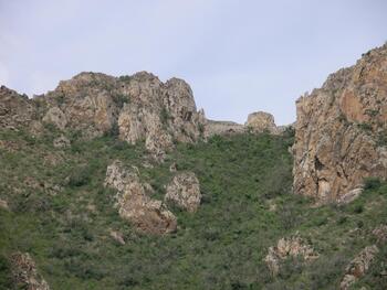
The mountain defile containing the tomb has a spring and a single entrance where there are remains of a wall and gate to guard access. On the hill beside the gate and further into the defile are three halls which may have housed eulogistic stelae mentioned in texts.Footnote 90 Figure 10 shows how the low points in the encircling ridge are filled in with drystone walls to create a more even profile, and similar infill walls are found, once again, at Wandu, which at the start of Deguang's reign was part of Balhae, a city-building regime which governed the northern Korean peninsula and southern Manchuria from the seventh century.Footnote 91 The Zuling tomb was built by the second Liao emperor, Deguang 德光 (r. 926–47), and he or his officials had opportunities to see such infill walls during the Liao conquest of the Balhae in 926 and in the process of taking over and governing the region.Footnote 92 The combination of Zuzhou and Zuling makes a landscape that includes mountains with a river running down to flatland – and ultimately to Shangjing – a burial ground, and ritual, residential, production and market areas. Zuzhou's walls were intended to be defensible, and indeed the city held out against attackers for long enough in 1119 to suffer extensive fire damage.Footnote 93
Infill walls at Zuling. Photo: Standen.

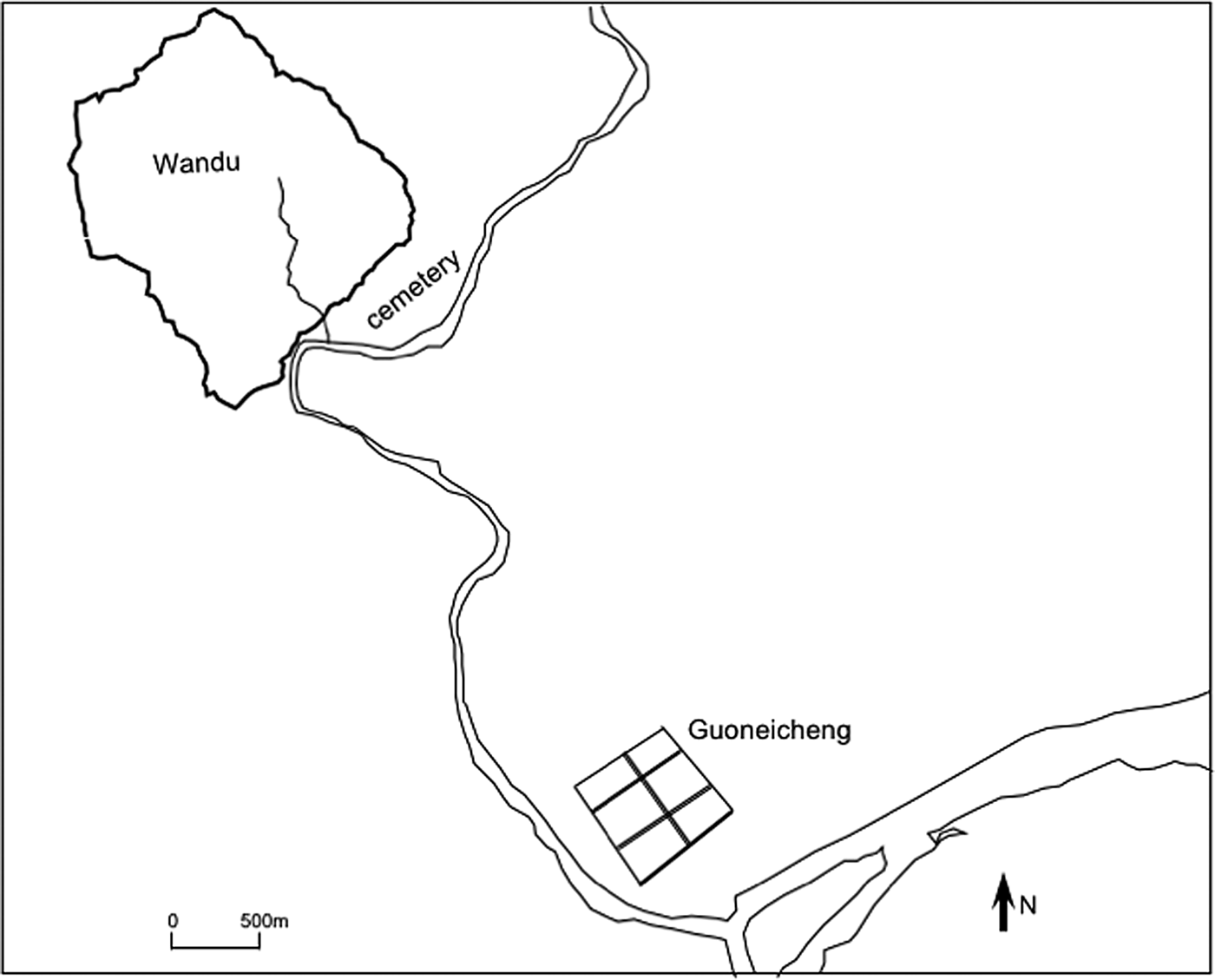
We also find this pairing of imperial burial grounds with defensible urban settlements in neighbouring mountain and flatter land in the Korean peninsula, with somewhat different purposes and arrangement. The urban landscape at Wandu mountain city near the North Korean border includes a city in the Changbai mountains 長白山 and another downstream nestled near a confluence on the Yalu (Figure 11). Wandu was the Goguryeo capital from 209 to 427, after which its associated ‘flatland city’, Guoneicheng 國內成, remained a secondary capital.Footnote 94 As just noted, the area was taken over by the Balhae, then conquered by the Liao in 926. There were many mountain cities; one scholar has tabulated the characteristics of sixty-seven, largely strung out along both banks of the Yalu and paired with a ‘flatland city’.Footnote 95 As is common in the northern Korean peninsula and southern Manchuria, most of these cities were built of stone, although a significant minority were of rammed earth.Footnote 96 Mountain cities made up 28 per cent of the 260 known urban sites in the region along the modern border, including nearly all of the largest. Most of these urban settlements seem to fall into eight regions, in each of which cities formed chains of fortifications along the six main routes in and out of Balhae. The Liao reused such sites as they did some cities used by the Uyghur Khaghanate, adding to the variety of forms in their urban portfolio.Footnote 97
Plan of Wandu mountain city and Guoneicheng. Image: Standen, based on Google Earth, with thanks to Gwen Bennett.

The plans of the mountain cities followed the often severe terrain, while the flatland cities could be closer to rectangular.Footnote 98 Wandu's outer walls form a strongly distorted diamond, while below it Guoneicheng is orientated to the north-east and is roughly square, with a broad transverse main street and two loosely orthogonal cross streets.Footnote 99 The walls of Wandu feature extensive surviving drystone walls using well-dressed blocks of regular size, surviving best at the lower edge where they include a gated wall that closes off access from the valley below, as at Zuling.Footnote 100 The mountain cities, Wandu among them, likewise feature infill walls of stone at the peaks of the surrounding mountains.Footnote 101 Wandu is also typical in having good access to springs for water, and like other mountain cities it has a reservoir too. The city contains a large ‘palace’ building set on two narrower hillside terraces flanking a wider one, where rows of column bases suggest two ‘corridor’ halls around a larger space.Footnote 102 This is a design also found at other Balhae sites such as Balhae Shangjing.Footnote 103 As often in northern settlements, kangs (sleeping or living platforms heated from beneath) are commonly found, and roof decorations are distinctive.Footnote 104
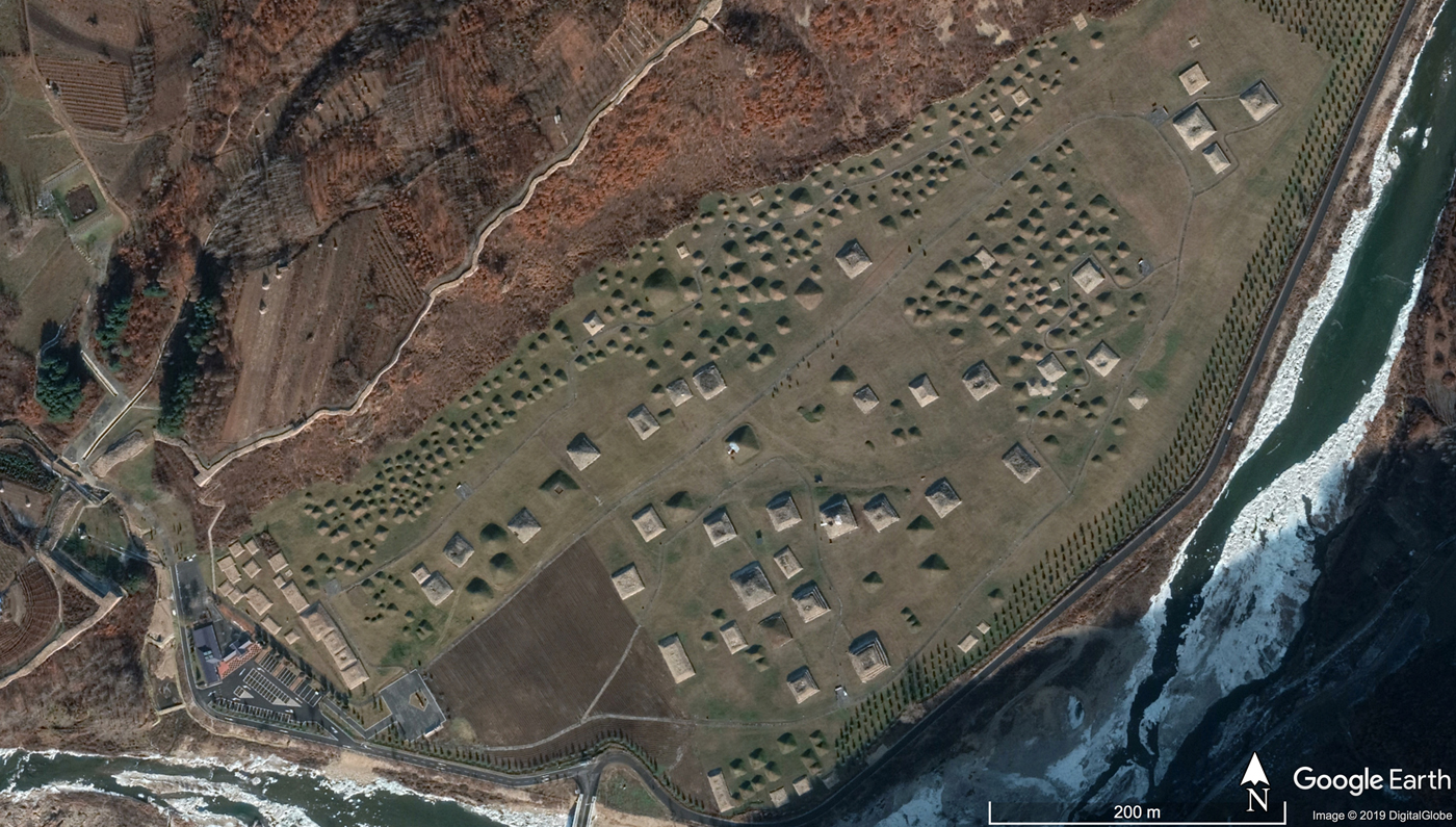
Despite serving as a capital, Wandu is not described in the twelfth-century history of Goguryeo, which provides only the barest indication of the administrative structure within which cities like Wandu and Guoneicheng were presumably situated.Footnote 105 Given the locations and fortifications of the mountain cities, scholars have naturally argued that they were primarily for defence in the context of a highly fragmented political situation including attacks from the west, and especially from the Tang.Footnote 106 This is convincing enough for the paired mountain and flatland cities in general, but at Wandu there is a remarkable additional element, for the mountain city presides over a large extramural cemetery on the riverbank 3 km upstream of Guoneicheng, containing dozens of tombs of which some use stone slabs and many use blocks (Figures 12 and 13).Footnote 107 The extensive use of stone both for tombs and for some city walls makes sense in the rocky environment of the region, and may be taken to mark one geographical limit of the substrate created by the overwhelming predominance of rammed-earth surrounding walls down to at least the eleventh century.
The Goguryeo tombs at Ji'an, Jilin. Image: Google Earth.

A slab tomb: accompanying burial #1 of the ‘General's tomb’, Ji'an. Photo: Standen.

Comparison of Wandu and Guoneicheng with Zuzhou and Zuling, each pair located in its own landscape, is not a simple matter. As at the other sites discussed here, the substrate elements of rammed-earth construction, regular shapes where landscape allows, nested enclosures, pillared buildings, and planning are all present, and both paired cities were imbricated in their respective networks of administrative hierarchy. Both pairs would have been nodes of activity in trade, religion, production and supply, but we lack the evidence to comment on what connections may have existed, so their involvement in these networks can only be by inference. We see, however, that Zuzhou or its vicinity are claimed textually as part of the Liao court's political network, while spatial analysis identifies Wandu/Guoneicheng as part of a chain or network of defences. We note that several of the elements specific to these city pairs are similar: associated mountain and flatland sites, a relatively regular design for the lower city, a burial ground, infill walls between the surrounding mountain peaks, and at least one stone slab structure. The politics of death were also key elements of both locations, but were manifested in markedly different ways: dozens of highly visible riverside stone tombs as against a single hidden mountain tomb, which was located separately from a solitary enigmatic slab building; two walled enclosures or one; concealment in the mountains or defence. We do not (yet) know if any of these features drew these cities into a necropolitan network.Footnote 108 What we can say is that if Liao emperors or city designers sometimes appropriated elements from landscapes they saw in Balhae, they made their own creative and distinctive use of them, in some places combining that with what they selected from sites constructed by others such as Uyghur khaghans or Tang emperors, while also at times deploying features of their own such as concealed imperial burials. From such a mixture, or set of mixtures, it is impossible to identify a specifically ‘Liao’ urban style.
VI Conclusions
It is unhelpful to continue to frame the Liao – or indeed any eastern Eurasian polity – in terms of their relationship to Sinitic culture and its hegemonic source base.Footnote 109 Once other sources of inspiration are taken seriously, the idea that ‘Liao’ cities are unified by anything but their use by the Liao dynasty falls apart. Zhongjing was not a poor imitation of an idealised model that was not even followed by Tang Chang'an, but – why should we be surprised? – was built to fulfil specific needs and then evolved further by both accident and design. Liao Shangjing and khaghanal Ordu Baliq, both ‘steppe cities’, each featured large identifiable hinterlands of production and supply, and the extramural habitation that these required. Shangjing's planners had access to khaghanal models but it did not necessarily require direct appropriation to come up with similar solutions to a similar question: how to sustain a population concentration in one spot within an environment that did not lend itself to intensive exploitation. In the third comparison, Liao Zuzhou and Zuling exhibit some similar uses and features of Goguryeo paired mountain and flatland cities such as Wandu and Guoneicheng, complete with the latter pair's royal cemetery. Most of the shared elements of both pairs could be independent responses to specific and partly similar circumstances, and certainly generated diverse results that make the idea of borrowing as reductive as it is undemonstrable. The one exception may be the construction of infill walls between mountain peaks, a choice that has defied explanation and accordingly is hard to imagine arising independently in two places just a few hundred kilometres apart. If this one element was indeed an appropriation from Goguryeo to Liao, then it highlights the importance of considering each element separately rather than assuming the adoption of an entire package.
If we accept that it stretches the urban evidence to continue to see the Liao – to a greater or lesser exent – as simply imitators of the Tang, another option would be to regard the Liao as appropriating from multiple sources in a merely eclectic fashion; indecisive, incoherent, lacking clear identity, without direction. As much World History would have it, these are also the failings of pre-modernity more generally, before centralisation, systematisation, clear boundaries, and – a word that has been attempting a comeback lately – progress. Confident identifications of the Tang model in Liao forms might give way to a careful teasing out of what came from where in linear – or even complex – flows of transmission, but even the most generous interpretation of eclecticism only upends the paradigm; it does not replace it. In this view there is still something called ‘Liao urbanisation’ and the Liao still ‘borrow’ from their neighbours, just from many instead of one. However, the evidence presented here provides no features that clearly link Liao cities that do not also link many non-Liao cities. There is nothing distinctively ‘Liao’ about the cities used by that dynasty.
Instead of seeking common elements that might give these cities a discrete shared identity, we could hold the diversity as we meet it, and see different elements working at different levels and different scales. It is more instructive to reconsider cities such as Tang Chang'an and Liao Zhongjing as the urban elements within broader landscapes, and furthermore, from global perspectives that allow us to locate any given city within patterns created by substrates, networks and nodes. We might see a substrate of common techniques underpinning urban construction across the whole of eastern Eurasia, its origins effectively untraceable to contemporaries and at best hazy to us; belonging to none and used by all. The urban sites themselves may then be nodes of specific expression of itemised aspects more widely found, such as types of ground plan or methods for provisioning the city. Sets of those nodes might become linked into networks of varying density, shape, pattern, depth – such as a set of political relationships, an administrative hierarchy or a defensive chain. With a different set of cases or fresh evidence, commercial, religious, production, fiscal or other networks might be more prominent.
What makes a history global is precisely its refusal to sit within conventional bounds of nation-states, being prepared instead to follow the topic wherever it leads, which might be a chain of connections – or not – from Karabalgasun to Wandu or Chang'an, or might be a much shorter distance from the farmhouse to the urban centre. Either way, what we are choosing to see is the contemporary working of assumptions about how things were done that were shared with a constellation of other people who spoke different languages, ate different food, were under different jurisdictions, and so on. Thus our analyses should not be distracted by texts that arrange cities into hierarchies as a contribution towards imperial legibility both historical and historiographical; it may be hard to think without state boundaries, but it is worth the effort. We must also remember that while it may have been states that established urban centres, it was people who lived in them; many cities later lost their administrative status but not their inhabitants. The more useful unit of study is landscapes, which leads us to very different questions from what the sources want to tell us, and may speak better to our needs in the present.
It is a matter of importance that global histories of this kind and others offer some purchase on a key task for the present day: to denaturalise the idea of the nation-state. As I write, we are seeing only too clearly that where scholars present pre-modern histories in quasi-national terms then – wittingly or otherwise – they assist present-day nationalists. Historians can help by writing firmly non-national histories – global histories – in which medieval periods have a particularly valuable role, precisely because this age can more readily stand outside the trajectories towards nationalism that seem impossible for modernists to avoid.
Presentist politics aside, global approaches to the pre-modern may also help us to escape from historical writing that is too often competitive, and even triumphalist. Books concerned with some Big Picture are frequently underpinned by concern to find the biggest, earliest, strongest, greatest, longest, richest and so on. This kind of macho history not only becomes tiresome, but its emphasis on competition and expansion, power and money, centralisation and integration, misses out huge and crucial areas of human activity, to do with praxis, women (and children), and generally people who were not the ruling elite.
That is not a new observation, and I do not pretend to have all the answers, but I do believe it is important to apply to global history some of the approaches developed in other fields of history, and especially to emphasise the everyday: how people got their food, how politics and religion and power happened on the daily level, how children were acquired, how things moved around, and the painful realities of conflict. That means, of course, that we must read against the power-focused textual sources, and against the tendency to focus on the shinier parts of material culture, which are also focused on power, and we must seek out new sources as well. We cannot do it by ourselves. My current project strains at, if it does not overstep, my own capabilities – I do not read Korean, for example. We have to collaborate, cooperate and listen to each other. In the present state of the world, that in itself is a radical move.