INTRODUCTION
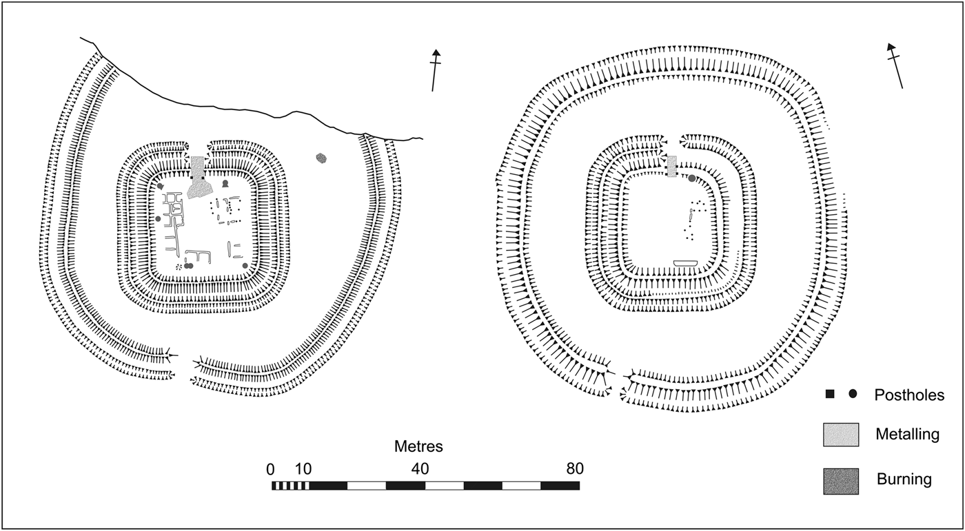
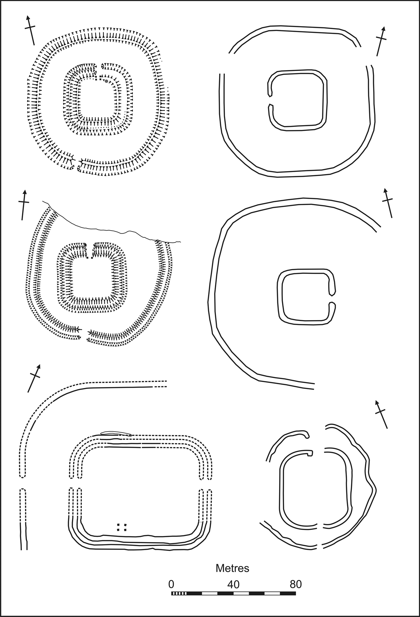
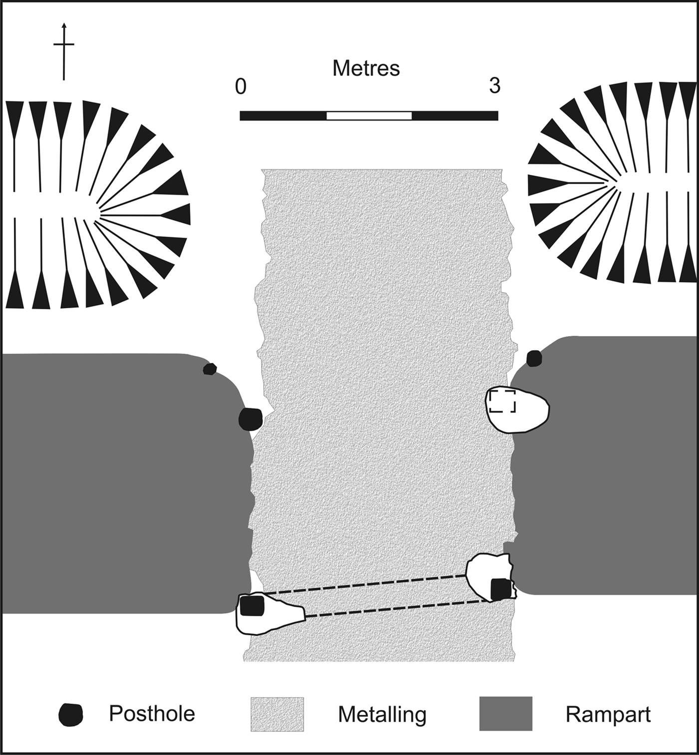
Between 1960 and 1963 Aileen Fox and William Ravenhill excavated two earthworks at Old Burrow and Martinhoe in north Devon,Footnote 1 which occupy cliff-top sites at the interface between the Exmoor uplands and the Bristol Channel. Originally interpreted as counterparts of the so-called signal stations erected on the north Yorkshire coast in the late fourth century,Footnote 2 Fox and Ravenhill's campaign established that the Exmoor installations were fortlets founded in the mid-first century a.d.Footnote 3 The principal reason for their original misidentification is that Old Burrow and Martinhoe represent examples of a short-lived, tightly focused and defensively flawed regional design variant. In stark contrast to standard fortlet design, these bivallate installations feature a pair of broadly concentric inner and outer enclosures (fig. 1). Currently only six instances of fortlets constructed to these specifications are known, five of which occur within the bounds of modern Devon (fig. 2).
The fortlets at Martinhoe (left) and Old Burrow (right), based on earthwork survey and excavation. Far less of the interior of Old Burrow was excavated. (After Fox and Ravenhill Reference Fox and Ravenhill1966; Riley and Wilson-North Reference Riley and Wilson-North2001)

The inner and outer enclosures of the six ‘concentric’ fortlets currently known: Old Burrow (top left), Ide (top right); Martinhoe (middle left), Stoke Hill (middle right), Pomeroy Wood (bottom left), and Cemlyn (bottom right). (After Fox and Ravenhill Reference Fox and Ravenhill1966; Griffith Reference Griffith1984; Fox and Ravenhill Reference Fox and Ravenhill1959; Salvatore Reference Salvatore2011; Chapman Reference Chapman2016)
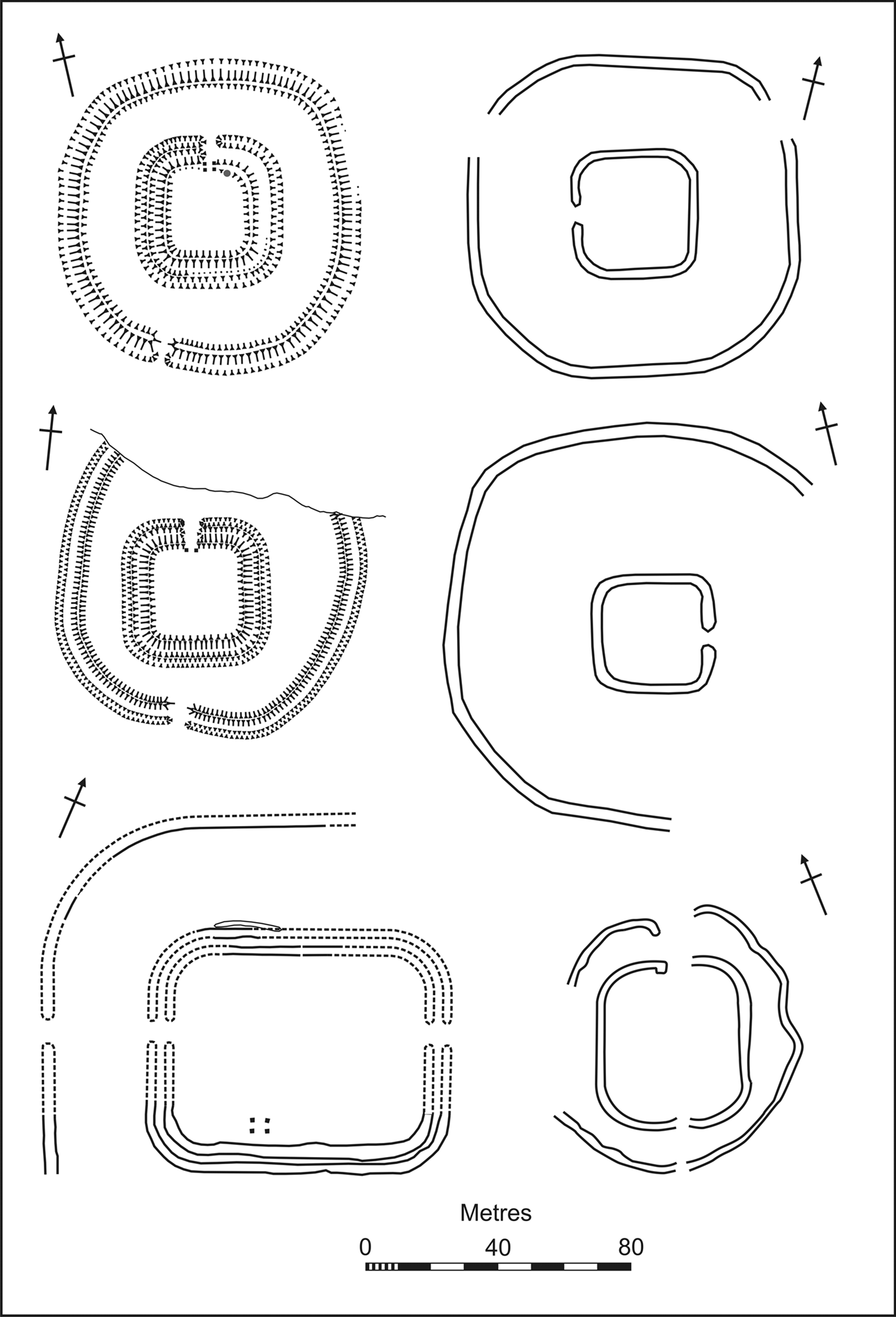
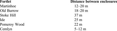
The distribution of this fortlet design variant coincides with a local tradition of constructing settlements comprising roughly concentric compounds.Footnote 4 Unlike the multivallate Iron Age enclosures to the east, where the ramparts typically form contiguous ranks, in the South-West the earthworks were often set 20 m or more apart. This convention is broadly adhered to by the five Devon fortlets, creating an overlap in technique between local settlements and some small Roman military installations (Table 1). Although models of cultural transfusion in Roman Britain have become increasingly sophisticated in recent decades, hybridisation of fortification techniques has not been detected. That the army paid close attention to indigenous settlement in the South-West is further implied by the positions of the fortlets, which seem well calibrated to strengthen pre-existing local measures to secure the coastline. Such apparent receptivity to indigenous needs and architecture implies closer co-operation between the local population and the army than is typically discernible in the archaeology of Roman Britain.Footnote 5 This paper will explore the implications of Roman military activity along the Exmoor coast for perceptions of the relationship between occupier and occupied.
APPROXIMATE DISTANCE FROM THE INNER AND OUTER ENCLOSURES (ALLOWING FOR A 3 M-WIDE OUTER RAMPART AT STOKE HILL, IDE, POMEROY WOOD AND CEMLYN)

THE ROLE OF FORTLET GARRISONS
Despite the prominence of Roman military studies in the archaeological literature, the role of fortlet garrisons has rarely been subject to detailed scrutiny.Footnote 6 There is still no universally recognised definition of a ‘fortlet’,Footnote 7 although the term can convincingly be applied to installations that provided secure accommodation for a garrison drawn from units whose home base lay elsewhere. On this reading, the key distinction between a fort and a fortlet is the absence of a formal principia or headquarters building from the latter.Footnote 8 In practice, though, fortlets are usually identifiable by virtue of their size. The c. 230 sites in Britain that are known or believed to meet this criterion display a more flexible design template than forts and fortresses. Although fortlets probably usually held a garrison of 80 or fewer,Footnote 9 internal areas range from under 200 m2 to in excess of 4,000 m2. This variety is not solely attributable to fluctuations in garrison size, but was frequently determined by the presence or absence of specialist ancillary buildings, including granaries, workshops, administrative areas and ritual space.Footnote 10 One staple of fort and fortress layouts that is conspicuously absent from most fortlets is monumental architecture. Although candidates for fortlet commanders’ quarters are often proposed, they are usually ambiguous and in some cases no distinction in living space is discernible.Footnote 11 This provides an intriguing caveat to Gardner's observation about the role architecture played in structuring army life by reinforcing hierarchy.Footnote 12
Given the vulnerability of small garrisons during episodes of open warfare, fortlets appear most appropriate as a mechanism to consolidate local control in the aftermath of conquest or during periods when security was contested. In contrast to forts and fortresses, which were essential to quarter and administer the units comprising an occupying force, establishing a network of fortlets does not appear to have been an automatic by-product of conquest. Instead, the extant distribution would accord, both geographically and chronologically, with fortlet garrisons only being deployed where and when they were needed in order to alleviate specific local pressures. The sparse finds assemblages hinder precision, but away from the frontiers these posts rarely seem to have been occupied for longer than a decade or two before being decommissioned. This relative dynamism is reflected in the scarcity of turf and timber fortlets in Britain that remained in operation long enough to warrant a masonry rebuild.Footnote 13
The surviving documentary evidence suggests that outpost garrisons overwhelmingly comprised soldiers drawn from the auxilia.Footnote 14 Finds of harness fittings within various European fortlets indicate the presence of a mounted element,Footnote 15 while the faunal assemblage from a Danube fortlet implies that horses were being bred on site.Footnote 16 This fits with information recorded on ostraca recovered from fortlets in the Egyptian Eastern Desert, where garrisons routinely comprised infantry and cavalry.Footnote 17 There, the cavalry were employed to courier messages rapidly from fortlet to fortlet, to provide escorts and patrols, and, when necessary, to fight alongside the infantry. Although there is no direct evidence for cavalry at either Martinhoe or Old Burrow, movement on foot in their hinterland remains slow to this day and the provision of horses would have substantially enhanced the garrisons’ reach and utility. The two fortlets are not intervisible and even if a relay tower was established, mounted dispatch riders would still be the only way to exchange detailed information swiftly. Such communication would be essential if the garrisons sought to co-ordinate their activity.
THE EXMOOR FORTLETS
Old Burrow and Martinhoe lie 13 km apart, at heights of 330 m and 247 m OD respectively, on coastal cliffs intermittently punctuated by steep valleys (figs 3 and 4). Fortlets in Britain were usually positioned either adjacent to or within a couple of kilometres of a metalled highway.Footnote 18 No such thoroughfare is known to have traversed Exmoor's coastal tract, leaving Old Burrow and Martinhoe conspicuously remote from the extant Roman military infrastructure. Although it seems likely that an unsurfaced track existed, the fortlet garrisons were separated from the nearest known candidate for a fort, at Rainsbury,Footnote 19 by 30–40 km of difficult upland terrain.
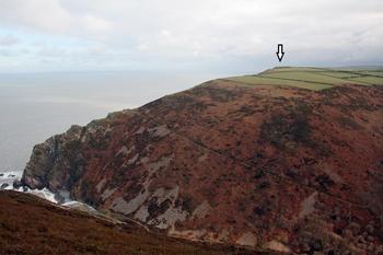
The location of Martinhoe (arrowed), directly east of the landing ground and entry point at Heddon's Mouth.

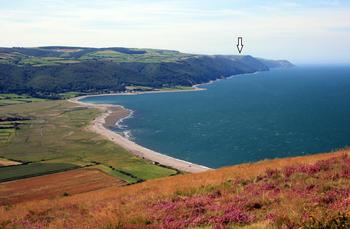
The location of Old Burrow (arrowed), as seen from near Hurlstone Point looking west towards Foreland Point, with Porlock Bay in the foreground. These two headlands divide this stretch of coast into a natural sector, which Old Burrow is positioned west of centre within. This location left the fortlet garrison well placed to observe the approaches to all of the maritime entry points along this stretch of coast.

Both installations lie adjacent to landing grounds — Glenthorne at Old Burrow and Heddon's Mouth at Martinhoe — which presumably eased the logistical challenge their locations presented by allowing provisions to be shipped in via the Bristol Channel.Footnote 20 An early naval depot lay 80 km up-channel at Sea Mills, while additional facilities have been proposed along the river Parrett, 60 km east of Old Burrow.Footnote 21 Even so, on current knowledge, it would be difficult to reinforce the fortlets rapidly, and impossible if adverse weather closed the Bristol Channel and made any overland track unpassable, suggesting that the garrisons were judged appropriate to tackle anticipated levels of local disruption. Attempts to calculate garrison size have produced widely varying estimates,Footnote 22 but a c. 40-strong garrison seems plausible. Assuming a third of those soldiers were on duty at any given time, while the remainder rested, this would provide c. 13 men to undertake routine duties in and around each fortlet.
The fortlets lie on land assigned to the Dumnonii, a group whose territory is generally believed to encompass the South-West peninsula as far east as the rivers Axe and Parrett.Footnote 23 There is no record of conflict between the Romans and the Dumnonii in the ancient literature and this, coupled with a seemingly inchoate military infrastructure, inspired the traditional view that the group was swift to submit to imperial suzerainty, or even ‘allied’.Footnote 24 Subsequent discoveries have revealed a more extensive military network, with concomitant implications for perceptions of the relationship between the Dumnonii and the Roman army. Nevertheless, a growing appreciation of Roman mineral exploitation provides an alternative explanation for military interest in the region.Footnote 25 The extent to which the dispersed society encompassed by the ‘Dumnonian’ label truly represented a cohesive political entity remains debatable and it is likely that responses to the arrival of Roman soldiers by local communities varied within the South-West. Differences between settlement development in the east and west of the peninsula clearly existed during the late Iron Age and the Roman period,Footnote 26 for instance, while further diversity can be detected within discrete portions of these regions.Footnote 27
There is no ambiguity concerning the attitude of the Dumnonii's neighbours across the Bristol Channel. Tacitus chronicles a quarter of a century of intermittent conflict between the Roman army and the Silures, from a.d. 49 to 73/4.Footnote 28 Fox and Ravenhill believed that the campaign in southern Wales provided the impetus for the construction of the Exmoor fortlets,Footnote 29 a conclusion that is supported by their landscape setting. The views they command are poorly suited to oversee activity within the Exmoor interior, but they do permit extensive surveillance of the Bristol Channel. On a clear day a 100-km swathe of southern Wales is visible, extending from Lavernock Point, near Cardiff, across Swansea Bay to Worm's Head, on the Gower.Footnote 30 This coastal plain represents a substantial stretch of the most fertile and presumably populous portion of Silurian territory.Footnote 31 Fox and Ravenhill inferred that their garrisons’ role was to undertake surveillance of the Silurian shore and to communicate sightings of raiding vessels, or even a full-blown invasion fleet, to Classis Britannica boats patrolling the Bristol Channel. A concentration of burning within the outer enclosure at Martinhoe was interpreted as residue from a signal beacon.Footnote 32 This interpretation casts the installations as observation and communication assets, manned by garrisons that were judged ‘expendable in the event of a serious Silurian attack or Dumnonian rising’.Footnote 33
CHRONOLOGY
One complication for the ‘signal station’ hypothesis is that the fortlets share a near-identical view of the Welsh coastline, creating a surveillance redundancy. This problem was obviated by Fox and Ravenhill's reading of the numismatic, structural and topographic evidence, which led them to conclude that the two fortlets were successive foundations.Footnote 34 Although their role as signal stations has been widely accepted, the case for sequential occupation has received a more qualified reception. Riley and Wilson-North have described the evidence as ‘slender’, while Todd proposed that the fortlets were complementary components of a wider coastal cordon.Footnote 35 The possibility that it extended to the east finds some support from cropmarks at Vellow, just beyond the modern National Park boundary. They reveal a bivallate enclosure not unlike the Old Burrow and Martinhoe defences, which is reasonably well positioned to control passage inland along the Doniford Stream. Even so, Vellow diverges from the Exmoor fortlets in three ways: it does not lie on the coast; has produced pottery dating from the second to the third or fourth century; and has inner and outer ditches of very different width.Footnote 36 Whether Vellow is a military work or a rural enclosure remains unclear, although the apparent date range favours the latter possibility, assuming it is not a product of later reuse of the site.Footnote 37 A variation on the coastal cordon thesis has identified the Exmoor fortlets as links in a chain of navigational aids extending into Cornwall, although this interpretation is also questionable.Footnote 38
The argument that the Exmoor fortlets were occupied sequentially relies on two strands of evidence: the apparent absence of permanent barrack blocks within Old Burrow and the finds assemblages. The former may well be illusory, however, as the articulation and dimensions of the structural features detected in Old Burrow resemble truncated vestiges of the timber barrack blocks excavated at Martinhoe (fig. 1).Footnote 39 Reuse of the Old Burrow earthworks within a post-Roman field-system could explain why its interior suffered greater degradation.Footnote 40 The direct dating evidence presented by the finds assemblages is also inadequate to support a fine-resolution chronology. Pottery from Martinhoe was assigned to a.d. 55–75, while that from Old Burrow, on analogy with Exeter, was dated to a.d. 50/55–80. The exclusive presence of ‘native’ pottery in Old Burrow was emphasised by the excavators,Footnote 41 but this can now be identified as a mixture of BB1, a small quantity of Exeter Fortress Ware and a few heavily gritted sherds that might represent a local Iron Age tradition. Paul Bidwell observes that such an assemblage can be considered ‘standard issue’ for a military unit in the South-West.Footnote 42 There is, then, nothing in the finds or structural evidence to support sequential occupation of the fortlets.
THE PHYSICAL GEOGRAPHY
The combined ability of the fortlets to control the Exmoor coastline strongly implies that they were conceived as a pair. Porlock Bay, which represents the ‘obvious landing place’,Footnote 43 is visible from Old Burrow, but not from Martinhoe. The latter fortlet does, however, have a clear view over the approach to Lynmouth, the second most significant entrepôt along the Exmoor coast, which in turn cannot be seen from Old Burrow. Indeed, it is unlikely to be a coincidence that the view east–west along the Exmoor coast from the two fortlets is mutually exclusive. The topography naturally divides this shoreline into two conjoining sectors, the westerly one stretching for 17 km from Little Hangman to Foreland Point and the easterly stretch running for 15 km between Foreland Point and Hurlstone Point (figs 4 and 5). Martinhoe lies roughly central within the former sector, while Old Burrow was constructed west of centre in the latter. By acting in consort, the two fortlets were capable of maintaining surveillance over a 32-km swathe of coast.Footnote 44
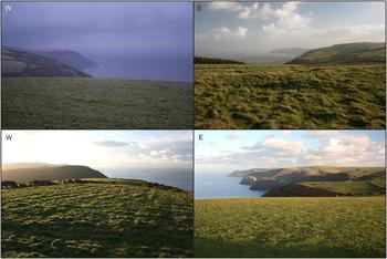
The view east and west along the coast from ground level at Old Burrow (top) and Martinhoe (bottom). Note that Foreland Point can be seen west of Old Burrow and is also the furthest headland visible east of Martinhoe.

This configuration suggests that the fortlet garrisons not only monitored maritime activity, but were also positioned so that they could intervene to control access to Roman territory from the Bristol Channel. A limited intervention remit would fit with the use of fortlets rather than towers. Although the garrisons appear small in the context of open warfare, detachments of professional soldiers would act as a deterrent to raiding parties, particularly ones motivated by profit or prestige rather than a desire to engage Roman forces for ideological reasons.Footnote 45 The Egyptian ostraca preserve reports of various actions against ‘barbarian’ bands ranging from 18 to 61 strong,Footnote 46 providing an insight into the magnitude of threat that fortlet garrisons were deemed capable of countering. Although the groups involved are modest in size, they could still cause considerable disruption if left unchecked.
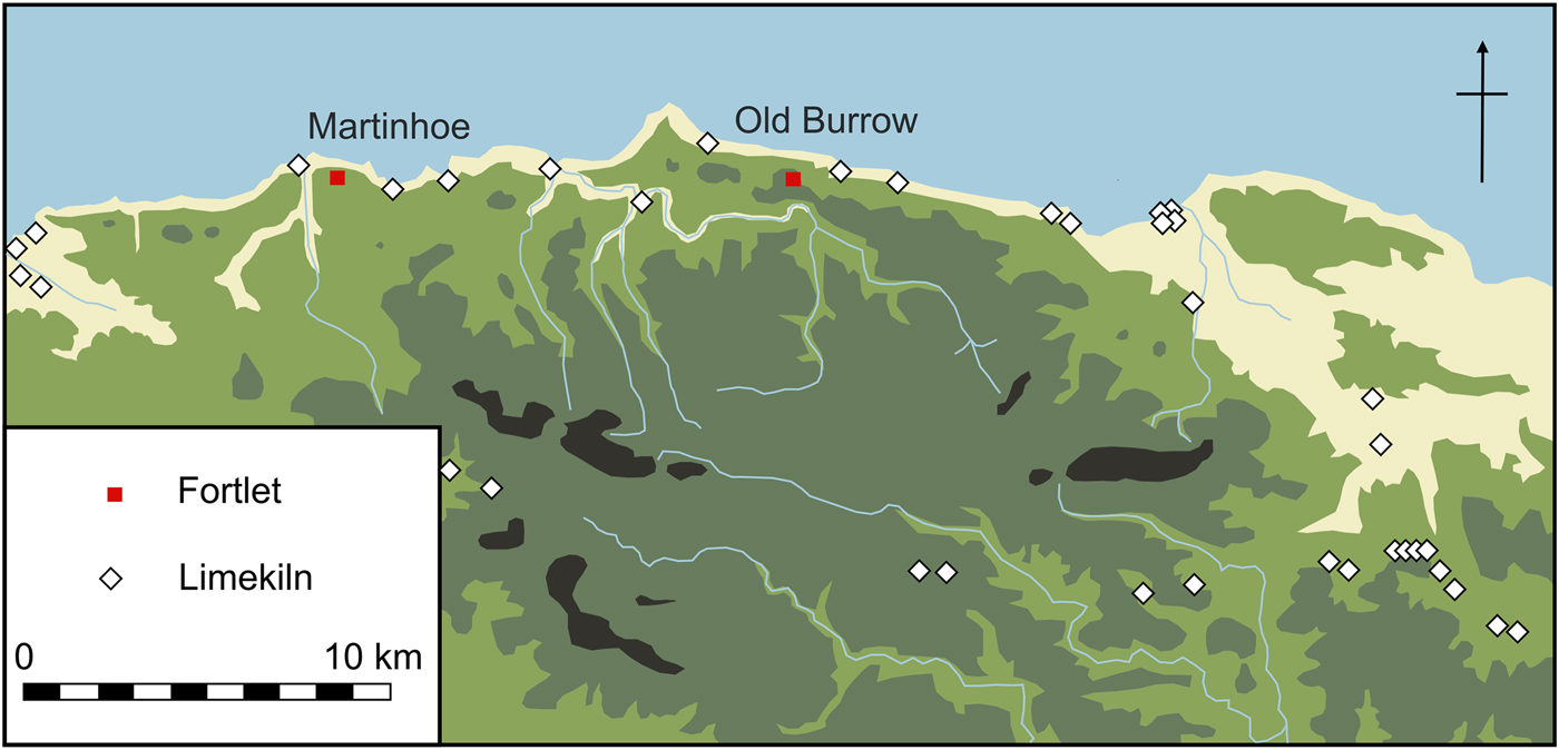
That the fortlets were sited with reference to potential landing grounds can be inferred from Exmoor's more recent industrial heritage. During the late eighteenth century, boats laden with limestone and culm would sail from southern Wales and either dock in the harbours at Porlock Weir and Lynmouth, or beach along the coast to offload their cargoes. Bulk goods from Exmoor would then be loaded for the return journey to Wales. In order to expedite transport into the Exmoor interior, the limestone would be burnt into quicklime in foreshore kilns.Footnote 47 The distribution of these lime kilns should, therefore, provide a proxy for the locations where boats could land safely and goods could be conveyed from the interior (fig. 6). This combination would be essential for coastal raiders, if they wished to carry any quantity of spoils away with them. Although the rate of coastal erosion at Martinhoe and Old Burrow over the last 2,000 years is not known, the occurrence of episodic slumping is attested by the loss of a portion of the outer enclosure at the former. Even so, there is no reason to believe that the fortlets lay significantly further inland during the Roman period.Footnote 48 Unless sea-level was markedly different during the Roman period,Footnote 49 it seems likely that the points of ingress denoted by these kilns are broadly representative of the landing grounds and entry points available during the first century.
The location of the Exmoor fortlets seen alongside the extant distribution of eighteenth- and nineteenth-century lime kilns. (After Riley and Wilson-North Reference Riley and Wilson-North2001)

The extant kiln sites along the coastal sector covered by Martinhoe are potentially relevant for understanding the priorities that determined the fortlet's precise position. This stretch of coast is split in two by the Heddon valley, while its mouth is flanked by two high bluffs, which rise to heights of 247 m and 248 m. Each summit restricts observation along the coast from the other, forcing a choice on the fortlet builders. The westerly bluff offers vastly superior views to the west and south, an identical view to the north, and an inferior view only to the east. Its summit provides a platform that is eminently suitable for a fortlet, while a spring rises only 700 m distant. Nevertheless, the fortlet was erected on the eastern bluff (fig. 3). Although this decision left the fortlet with a superior prospect in only one direction — to the east — this allowed the garrison to monitor the approaches to all four of the landing grounds in this sector where kilns were later constructed. From the western bluff only one of these points could be overseen. This disparity is due to a change in the geology west of Heddon's Mouth, where the harder Hangman Grits have been less deeply incised by watercourses, rendering the beaches difficult of access.Footnote 50 Placing Martinhoe on the eastern bluff resulted in the pair of Exmoor fortlets being capable of closely monitoring the approaches to all the landing grounds within these two sectors denoted by later kiln sites.
Although a desire to control landing grounds and entry points provides a compelling explanation for the location of the two fortlets, the apparent failure to garrison Porlock Bay and Lynmouth is conspicuous. As both lie at the eastern ends of the naturally subdividing coastal sectors, it could be argued that it made more sense to deploy garrisons roughly centrally within these stretches. Nevertheless, suitable settings with expansive views exist adjacent to Porlock Bay and Lynmouth, presenting a means for any garrison to be both immediate to the principal landing grounds and oversee the wider coastline. Naturally, it remains entirely possible that additional installations were founded in the vicinity of Porlock Bay and Lynmouth, but despite them being identified as strong candidates for such posts,Footnote 51 no trace of a military presence has yet been detected. This apparent aberration in the relationship between the military deployment and the physical geography could conceivably be resolved by factoring in the human geography.
THE HUMAN GEOGRAPHY
The cross-Channel connectivity of eighteenth- and nineteenth-century coastal communities raises the question of whether comparable commerce occurred between the Dumnonii and Silures. Attempting to reconstruct the human geography in the decades leading up to the Roman occupation is riven with uncertainties. Although the evidence for activity on Exmoor and in the Bristol Channel at this time is slender, attempting to understand it is crucial to gauging the measures undertaken by the Roman army to control this region.
COASTAL TRADE
The area of Siluria that falls within modern Gwent has been characterised as ‘a continuously utilised coastal landscape with boat landing points and trackways leading inland’,Footnote 52 suggesting that the Silures could count competent sailors among their number. Continuities in settlement morphology on either side of the Bristol Channel have also been attributed to a confluence of ‘environment, economy, and commercial communications’. Attempting to quantify this latter, though, is currently impossible. Neither the Dumnonii nor Silures minted coins, while the nature or even existence of late Iron Age pottery production in north Devon remains ambiguous,Footnote 53 eliminating two obvious indices for trade. Although sherds of South-Western Decorated Ware have been found in sites on the Glamorgan coast,Footnote 54 almost by default any regular trade would have involved archaeologically less tangible materials, such as foodstuffs. By the late Roman period tin and iron may have been the principal drivers of maritime trade around the peninsula, but the scale of late Iron Age exploitation of these resources remains unclear.Footnote 55
Whether long-distance shipping entered the Bristol Channel in the late Iron Age is even harder to assess. Merthyr Mawr Warren at the mouth of the river Ogmore in South Wales has been proposed as a possible ‘major entry port’ during the period from the fifth to second century b.c.Footnote 56 Although trade along the Atlantic axis contracted as Rome consolidated its grip on Gaul in the mid-first century b.c.,Footnote 57 the mouth of the Ogmore lies directly opposite the Exmoor coastal sector controlled by Old Burrow fortlet. If the potential port at Merthyr Mawr Warren retained any importance in the mid-first century a.d. it would certainly help explain why efforts were made to secure the opposite shore. A survey of imported material culture found in Siluria has emphasised the scope for direct maritime links with the South-West peninsula and Armorica during the later Iron Age,Footnote 58 although what little evidence there is favours short-haul cabotage over long-distance shipping as the principal means of conveying commodities along the coast.Footnote 59
The arrival of the Roman military presumably brought an increase in traffic to the Bristol Channel, not just to supply the fortlets, but also the legionary fortresses founded at Kingsholm and Usk in the a.d. 50s.Footnote 60 South-East Dorset and South-Western BB1 pottery is found in early forts in South Wales and presumably arrived by sea, suggesting shipments originating on the south coast of Britain.Footnote 61 Naturally, any perceived risk to maritime supply lines would make a military presence along the shore desirable. This also emphasises that pottery from the South-West can be detected in South Wales both before South-Western Decorated Ware ceased production in the first century b.c. and in the second half of the first century a.d. to supply the army. It seems likely — though naturally speculative — that the intervening period says more about the archaeological visibility of the cargoes than any cessation in short-haul maritime trade around the Bristol Channel. If the presence of coastal settlements, traders and vessels carrying cargo also attracted pirates and raiders, it seems equally likely that local communities would have developed measures to combat such threats.
AGRICULTURE AND MINERAL EXTRACTION
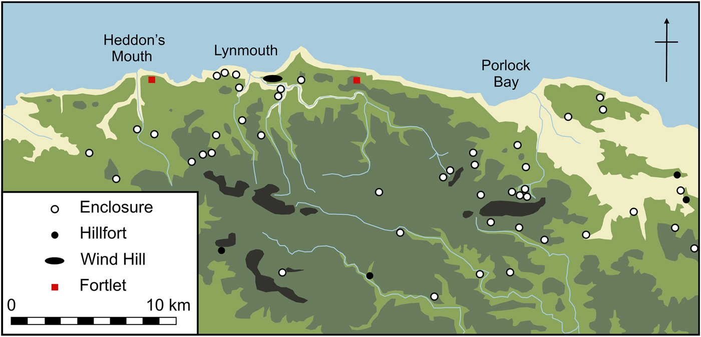
A scatter of Iron Age-style enclosures on Exmoor could suggest that both the coast and interior were home to a settled community during the conquest period. Pollen cores from several upland sites support this inference by indicating continuity of agricultural regimes from the late Iron Age into at least the early Roman period and in most cases through until the post-Roman period. Although maintaining open ground to provide seasonal grazing for cattle was the dominant endeavour, the environmental evidence demonstrated that in places cereal cultivation was underway, confirming the implications of the probable late prehistoric arable fields on Withycombe Hill. Patches of managed woodland may also have been retained.Footnote 62 Analysis of cores from the southern fringes of Exmoor ‘strongly suggests continuity and stability in the land use … for a period of up to 1,000 years, and there is no reflection of the Roman period within the landscape’.Footnote 63 Despite this evidence for uninterrupted agriculture, the paucity of dating evidence from Iron Age-style settlement on Exmoor leaves it unclear whether these sites endured into the Roman period. Assessing the likelihood of this is crucial to understanding the context of the fortlets, especially as they appear most intelligible when considered in conjunction with pre-existing settlement patterns (fig. 7).
The location of the fortlets seen alongside known Iron Age-style settlement on Exmoor. (After Riley and Wilson-North Reference Riley and Wilson-North2001)

The possible late Iron Age habitation sites currently known on Exmoor can be subdivided into three categories: hillforts; promontory forts; and a type of site traditionally referred to as a hillslope enclosure. Much remains unknown about the last, which are typically viewed as farmsteads, although some were used for processing metal. Hillslope enclosures appear to be particularly widespread in north Devon during the Iron Age and Roman period, but they were constructed over a much longer timespan; examples ranging from the Neolithic period to the thirteenth century are known.Footnote 64 A survey of the limited dating evidence for such compounds in Devon predicted that ‘there will be a reasonable number which are of first millennium b.c. or Romano-British date …’, with the caveat that ‘the excavated sites are too few for sound conclusions to be drawn’.Footnote 65 Taken at face value such comparanda suggest that an appreciable proportion of the known hillslope enclosures on Exmoor may have been occupied around the time of the Iron Age/Roman transition. A degree of farmstead continuity would also seem a corollary of the sustained land management indicated by the environmental evidence.
While hillforts and promontory forts have generated a considerable body of literature, there is no scope to engage fully with it here. Although they represent the largest prehistoric monuments on Exmoor, the modestly sized hillforts usually only enclose c. 1–2 ha. Exmoor's sole promontory fort at Wind Hill, however, encompasses a hilltop plateau 35 ha in extent.Footnote 66 Rather than jutting into the sea, this commanding eminence runs parallel to the shore, dominating Lynmouth and controlling east–west passage along the coastal ridge. It has been described as ‘one of the few centres of political power which can be discerned in the south-western Iron Age’,Footnote 67 although such sites have also attracted less profane interpretations.Footnote 68 Archaeological investigation of the region's promontory forts remains limited, but radiocarbon dates from Embury Beacon, also on the north Devon coast, indicate a middle or late Iron Age date for the construction of the outer defences, which had fallen into neglect by the late Roman period.Footnote 69 Further west, all bar one of the Cornish promontory forts sampled by excavation revealed some activity in the Roman period.Footnote 70 The report on work at Trevelgue Head emphasises its role in metal production and explicitly compares it to the Exmoor hillforts, many of them also well placed to control iron ore deposits.Footnote 71
If minerals were being extracted on Exmoor it would provide an additional motive for military interest in the region.Footnote 72 Although transporting such goods to the landing grounds secured by the fortlets would not be easy, metal ingots could potentially be loaded onto boats and conveyed up the Bristol Channel to legionary workshops at Kingsholm and Usk. The presence of fortlets could also fit with the apparent use of these installations in conjunction with the exploitation of metal deposits at Charterhouse, Dolaucothi and Erglodd.Footnote 73 Whether the Exmoor hillforts lay at the heart of local extraction industries during the conquest period is, though, unclear. Riley and Wilson-North contend that ‘it is reasonable to assume that the hillforts and other enclosures [on Exmoor] were used by the Dumnonii into the Roman period …’.Footnote 74 Manning and Quinnell, however, emphasise that no hillforts within modern Devon are known to have been occupied during the late Iron Age.Footnote 75 The recent survey of Roman rural settlement in England and Wales succinctly summarises the situation in the South-West by observing that the hillforts ‘tend to continue until the 1st century AD, although in some cases may have continued into, or been renewed in the Roman period’.Footnote 76 Such uncertainty means a link between any pre-existing extraction industries centred on hillforts and Roman military activity cannot be securely forged. Two slag heaps dated to the late Iron Age/Roman period at Sherracombe and a coin of Domitian from ‘old workings’ on Kennisham Hill are consistent, though, with mining and iron ore processing being underway on Exmoor around the time of the conquest.Footnote 77
Given the acute chronological uncertainty outlined in the preceding paragraphs, attempting to draw wider inferences from Iron Age-style settlement on Exmoor could be perceived as tilting at windmills. Nevertheless, the pattern it reveals broadly mirrors the distribution of coastal habitation that endures to this day. Most of the Iron Age-style settlements lie, as might be expected, either on the fringes of the moor, or clustered near Porlock, Lynmouth and the adjacent Lynton,Footnote 78 which remain the principal population centres on the coast. As Porlock Vale comprises the most fertile farming land on Exmoor, it seems probable that additional prehistoric sites within this natural corridor have been levelled by subsequent agricultural activity. When the Iron Age-style sites are considered alongside the two fortlets, it is striking that Old Burrow and Martinhoe flank the promontory fort at Wind Hill, at a distance of 4.7 km and 6.5 km respectively (fig. 7). On analogy with the Cornish examples, the site at Wind Hill is also the most likely to have endured in some form into the Roman period. As it represents one of the few settlements in the region that could plausibly be proposed as a major political centre this relationship is potentially significant.Footnote 79 Indeed, two similar, though undated, fortlets at Ide and Stoke Hill control the approaches — albeit over land — to the fortress and later civitas capital at Exeter in an arguably comparable fashion. Aside from this potential relationship with Wind Hill, there is a conspicuous dearth of known Iron Age-style habitation in the immediate vicinity of the Exmoor fortlets (fig. 7). Although it is likely that some prehistoric settlement forms are disproportionately under-represented in the archaeological record, particularly unenclosed timber roundhouses,Footnote 80 there is no reason why they should be especially common in the vicinity of the fortlets, unless the soldiers themselves provided an economic impetus for their establishment. The hinterland of both fortlets remains sparsely inhabited today.
Erecting the Exmoor fortlets at remote landing grounds away from pre-existing settlements fits with an approach to fortlet deployment advocated on a second-century inscription series from Intercisa on the Danube. This explicitly states that outposts were founded ‘at advantageous places against the clandestine (clandestinos) crossings of bandits (latrunculi)’.Footnote 81 While the beaches below the Exmoor fortlets at Glenthorne and Heddon's Mouth would be well suited to clandestine landings, securing them would only be effective if Lynmouth and Porlock Bay were also controlled. Although vessels approaching these destinations could be monitored from the fortlets, the apparent failure to garrison these entry points directly might suggest that the local population was broadly trusted to regulate coastal traffic.Footnote 82 If local communities had suffered from and sought to curtail coastal raiding prior to the Roman occupation, then the use of fortlets to plug unsupervised landing grounds directly east and west of a potential population centre at Wind Hill is explicable as a means to strengthen existing measures. Enhancing coastal security would have been a mutually beneficial enterprise and, from a military perspective, would also circumvent the manpower and logistical demands of establishing a complete cordon from scratch. If coastal security was built on co-operation between the occupiers and occupied, it would have created a composite cordon very different in character to the unilateral frontier systems that developed in later decades.
CO-OPTING LOCAL ARCHITECTURE
The distinctive arrangement of broadly concentric inner and outer enclosures at Old Burrow and Martinhoe is also suggestive of Dumnonian influence. Although numerous fortlets were equipped with outworks, ranging from the massive 2-ha annex at Oxton, Borders,Footnote 83 to the irregular ditch system at Barburgh Mill, Dumfries and Galloway,Footnote 84 all but one of the known examples of concentric enclosure use occurs within modern Devon. Aside from the Exmoor pair, four further examples are attested: Stoke Hill and Ide near Exeter; Pomeroy Wood on the road to Dorchester; and Cemlyn controlling remote landing grounds on Anglesey.Footnote 85 The design of Cemlyn noticeably differs from the Devon examples as there is less of a gap between the inner and outer enclosures (fig. 2; Table 1). As it is also the example most distant from the original appearance of this design, in terms of space and probably also time, it is suggestive of an evolving format.
Despite the probability of a comparatively late foundation date for Cemlyn, all six examples were most likely constructed during the first century. While the inner enclosure contained the garrison accommodation and served as the fortlet proper, there is little trace of activity within the outworks. Site inspection reveals that some attempt was made to level off the inner platforms, but similar effort was not invested on the outer enclosures, supporting the notion that they were not seen as building plots. The possible beacon stance in the outer work at Martinhoe is undated and could easily be more recent in origin, as a tradition of lighting bonfires to celebrate important events endured on Exmoor into the twentieth century.Footnote 86 Excavation of the outer enclosure entrance at Old Burrow did not reveal any settings for gateposts,Footnote 87 although presumably there was some provision to seal the passageway in an emergency.Footnote 88
Fox and Ravenhill advocated a dual role for the outer enclosures at Old Burrow and Martinhoe. They proposed that the outer enclosures were initially dug to protect the construction parties, but were retained as an additional defensive feature once the fortlet was complete to ‘entice any attackers into the target area between the ramparts’. As the fortlet gateways were orientated north, while the outer enclosure entrances faced south, ‘all comers would be obliged to make a half-circuit of the defences under fire’ (fig. 1).Footnote 89 The small size of the garrisons makes it unlikely that a frontal assault was seriously considered probable, let alone actively encouraged, but an ostracon from the Egyptian Eastern Desert does provide an eye-witness account of an attack on a fortlet in a.d. 118:
I bring to your attention the fact that on the 17th of this same month of Phamenoth, 60 barbarians attacked the Patkoua praesidium. I fought with the comrades that I had with me from the tenth hour until the second hour of the night, and they besieged the fortlet until dawn. That day Hermogenes, infantryman of the century of Serenus, was killed, and a woman and two children were kidnapped, a(nother) child was killed. At the dawn of the 18th [of the same] month, we fought and Damanais, rider of the century of Victor (yours) [was killed?], Valerius Firm[…] was hit and his horse …Footnote 90
Two weaknesses in the design of Old Burrow suggest that it was never subjected to a comparable assault. Fortlet gates normally closed flush with the outer face of the rampart, to create an unbroken line of defence. The gateway to the inner enclosure at Old Burrow was arranged so that the timber sill beam lay parallel to the inner rather than outer rampart face,Footnote 91 meaning that the gateway was built back to front (fig. 8). Although rare, a comparable error occurred at the towns of Nicopolis ad Istrum and Augusta Traiana in Lower Moesia, where the portcullis lay on the wrong side of the second-century city gates.Footnote 92 As well as raising questions about the competence of the construction team, this mistake created a point of weakness — any attacker could attempt to force the gates while sheltering from defensive fire in the cavity between the rampart cheeks and under the gatetower. Although this flaw would have become apparent during an assault, there is no sign that it was ever rectified.
The sill beam for the fortlet gateway at Old Burrow indicates that it was constructed the wrong way around. (After Fox and Ravenhill Reference Fox and Ravenhill1966)

The second weakness is integral to the core concentric enclosure concept. In the event of an assault and siege similar to that described in Egypt, the fortlet outwork could easily undermine a garrison's ability to defend itself. Because the two sets of defences do not intersect, any soldiers manning the outer rampart could be cut off if it was breeched. If the outer rampart did fall, it would also provide the attackers with a ready-made siege work, isolating the defenders in the inner enclosure. As well as offering the attackers cover, the outwork would severely restrict the garrison's movements if they sought to lift the siege. It seems unlikely that such a fundamental weakness would have been tolerated if its shortcomings were fully appreciated. As the defences of almost every other British fortlet equipped with an annex do converge,Footnote 93 it could be inferred that ultimately the inadequacies of this arrangement became apparent. Indeed, the design of the sole comparable fortlet so far known beyond Devon, at Cemlyn, which also comprises a pair of broadly concentric enclosures, deviates from the Exmoor examples by placing the entrances to the two enclosures on the same side, reducing the risk that the outer work could be used to isolate the garrison.
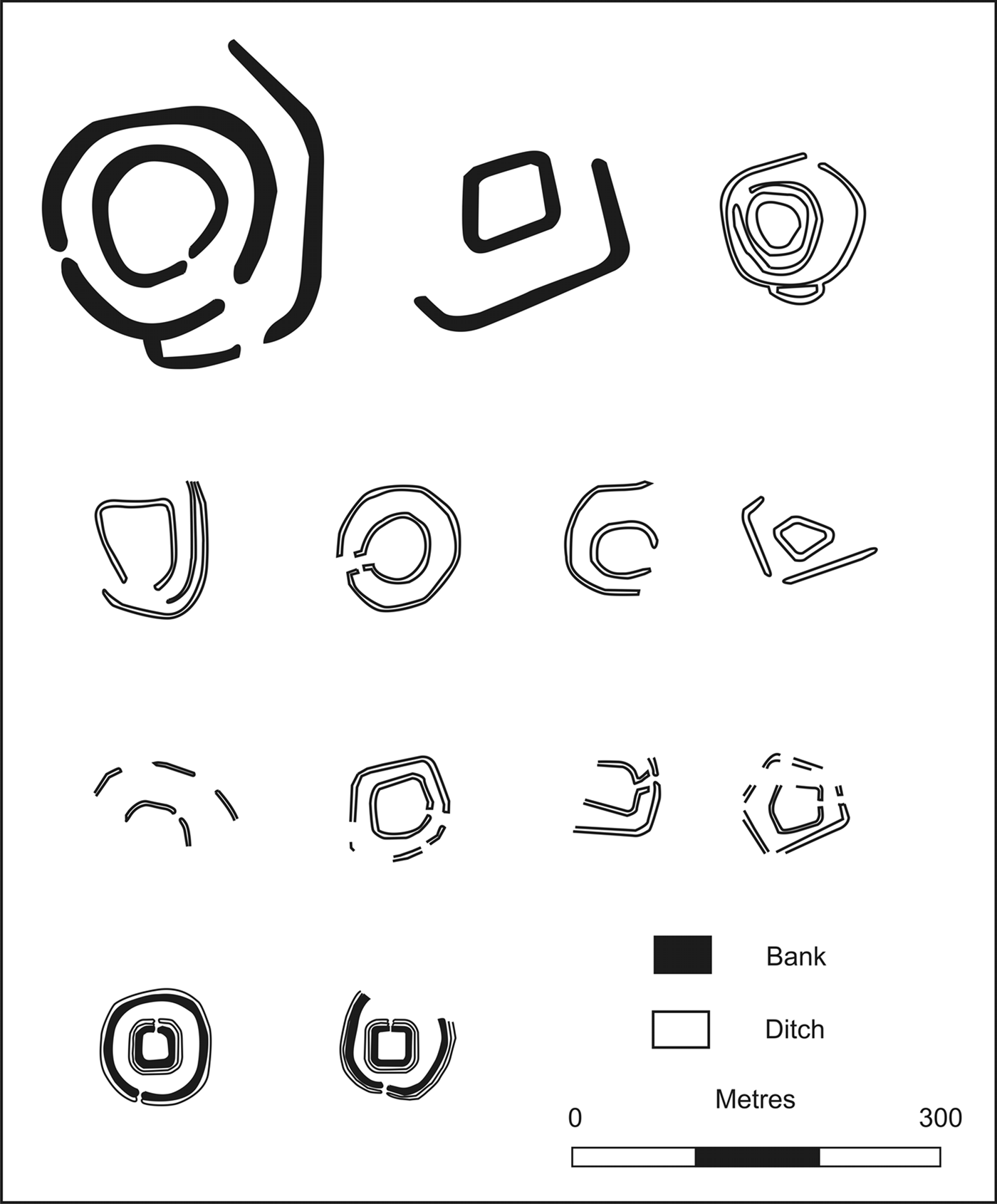
The distribution of these concentric fortlets coincides in the South-West with that of various multiple-enclosure Iron Age settlements described as ‘concentric’ by Fox, who identified them as a subset of hillslope enclosures. These settlements comprise two or more compounds arranged loosely around the same centre, with the inner enclosure often sub-rectangular in shape.Footnote 94 On the strength of the ‘inherent military weakness’ of hillslope enclosures in general, Fox viewed them as responses to economic, rather than martial, imperatives.Footnote 95 It is widely accepted that the general design would be well suited to allow pastoralists to live alongside livestock securely corralled against raiders and predatory animals.Footnote 96 The degree of similarity between some multiple-enclosure sites and the fortlets is illustrated by suggestions that Martinhoe and Stoke Hill could be indigenous sites,Footnote 97 while what is surely a local settlement at Newton Tracey, Devon, has been proposed as a possible fortlet.Footnote 98 Such overlap may explain the differences between the possible fortlet at Vellow and the nearby Exmoor installations: it could also be a local settlement.Footnote 99 The possibility that a further bivallate enclosure at East Leigh, Cornwall, could be a fortlet has also been discussed and plausibly dismissed.Footnote 100 Although the size of the various multiple-enclosure indigenous sites varies considerably, many are significantly larger than the concentric fortlets. Nevertheless, some smaller settlements fall within the size range of the fortlets (fig. 9).
The fortlets compared to multiple enclosure sites in the South-West: Tregeare Rounds, Bogee, Trenouth (row 1); Alverdiscott, High Treworder, Penpont, Hayle Farm (row 2); Newton Tracey, Middle Amble Farm 1, Middle Amble Farm 2, East Leigh (row 3); Old Burrow, Martinhoe (row 4). (After Young Reference Young2012, Maxfield Reference Maxfield, Hanson and Keppie1980; Fox and Ravenhill Reference Fox and Ravenhill1966)

That the outer fortlet enclosures could also be linked with the presence of animals is supported by waterlogged deposits at Pomeroy Wood, which preserved the remains of beetles associated with tethered animals.Footnote 101 This led Salvatore to infer that the outer enclosures ‘may simply have defined a military secured area outside the base which could be utilised for the grazing of cavalry horses or baggage animals …’.Footnote 102 Pack animals would certainly ease transporting supplies brought in by boat up the arduous ascent to the Exmoor fortlets, while the need for mounted relay riders to establish effective communication between these garrisons and the evidence for cavalry in the Egyptian ostraca have already been outlined. The ostraca also document the presence of other domesticated animals at some fortlets, including pigs and dogs.Footnote 103 It is widely appreciated that the Roman military excelled at adopting and adapting enemy or allied types of kit, artistry and terminology. Horse harness, helmet, sword, dagger, archery equipment and artillery designs are prominent among the many items of military equipment that were lifted from the fighting repertoire of other peoples.Footnote 104 Whether the Roman army drew inspiration from defensive — or perhaps more accurately protective — architecture employed by the Britons has not been seriously considered, probably because of the generally dismissive accounts of their martial prowess in the ancient literature. A desire to safeguard working animals may, however, have resulted in the uncritical absorption of a local technique employed for a similar purpose.
An alternative explanation for local influence in the design of the concentric fortlets is that the Roman army used Dumnonian work parties or even locally recruited soldiers to construct these installations. This latter possibility would fit with a suggestion that distinct building techniques identifiable in early fort ramparts on the Rhine are attributable to the differing construction traditions of the peoples comprising the auxilia.Footnote 105 As well as providing a reason why the building gangs constructed concentric enclosures in the local style, limited familiarity with Roman defensive techniques might also account for the Old Burrow gateway being erected the wrong way around. Concrete evidence for Dumnonian work parties being involved in a subsequent military construction project is attested on Hadrian's Wall, where two inscriptions record work by the civitas Dumnoniorum.Footnote 106 They are traditionally assigned to the fourth century, although recent reassessments have proposed much earlier dates in the second or early third century.Footnote 107 If Dumnonian corvées were employed on a military project in northern England in the second or third century, there seems to be no reason why they could not have provided a similar service on their home territory in the first century. This is particularly true if the Roman deployment brought tangible benefits to local communities by strengthening coastal security. Regardless of whether Roman or Dumnonian hands were responsible for constructing the Exmoor fortlets, a constructive relationship with the local population can be inferred from both the location and design of these installations.Footnote 108
Given the possibility of Dumnonian involvement in the construction of these fortlets, it is appropriate to consider who was manning them. The possibility that some were operated by local militias has been proposed in the past,Footnote 109 while more recent research on finds from Roman forts elsewhere in Britain has emphasised that indigenous weaponry can occur in quantities that seem to go beyond any allowance made for trophies. Its presence is a reminder that some local warriors fought alongside the Roman army, while others were probably recruited into the military; soldiers themselves could also adopt this kit.Footnote 110 No such weaponry was recovered from Old Burrow or Martinhoe, though the presence of a few sherds of possible local pottery is once again consistent with some form of relationship with the indigenous population. This is normally assumed to be a product of trade,Footnote 111 though it could also be attributed to the fortlet garrison including locals acting as militia. Given that the overall pottery assemblage is in keeping with that expected from military sites in the South-West more widely, however, it is more likely that the fortlets were held by regular soldiers.
DISCUSSION
Neither the structural nor the finds evidence from the Exmoor fortlets indicates that they were occupied sequentially. Instead, their location suggests that they operated as a pair to capitalise on the natural subdivision of the coastline into two sectors. If the extant eighteenth- and nineteenth-century lime kilns provide a proxy for viable maritime entry points during the Roman period, then the approaches to all along a 32-km stretch of coast were covered by these two installations. It is conceivable that the industrial connection runs deeper and the fortlets provided security for shipments of metals being mined and processed on Exmoor. On balance, though, their position suggests that controlling the wider coastline was the principal concern, rather than occupying the landing grounds where metals could most easily be transported.Footnote 112 Even so, these two roles are not mutually exclusive. As well as highlighting that the Roman army enjoyed an outstanding grasp of the topography, a focus on controlling access implies that the garrisons had an intercept as well as a surveillance capability.
The limited size of the fortlet garrisons and their distance from reinforcements makes it unlikely that combat with anything more sizeable than raiding parties was anticipated. It is possible that the army was concerned such groups could disrupt any mineral extraction underway inland, but it is equally plausible that this is simply an early manifestation of the Roman penchant for border control. As the Bristol Channel coast formed a de facto frontier zone from a.d. 49 to 74/5, measures to tighten security would be appropriate along stretches where unsupervised landing grounds and access points existed.Footnote 113 If a historical context is sought, one possibility is the elevation of Nero to the purple in a.d. 54, when Suetonius states the new emperor considered abandoning Britain, while the early years of his reign certainly ushered in a period of retrenchment.Footnote 114 As immediate aggressive expansion was unlikely against such a backdrop, it would have provided an impetus for the army to consolidate control of conquered territory.
Garrisoning two of the more isolated landing grounds along an already remote stretch of coastline is best understood as an extreme expression of the policy of controlling ‘clandestine’ landing places advocated on the inscriptions from Intercisa. If the absence of military installations at or near Lynmouth and Porlock Bay is real rather than apparent, it suggests that the army was confident that the local population could satisfactorily regulate these entrepôts. It was undoubtedly in both groups’ interest to ensure that the violent upheaval underway in South Wales did not spill across the Bristol Channel. Such alliances, or at least accommodations, between the invaders and elements of the local population during the conquest period are well attested in the ancient literature. The seemingly complementary distribution of military installations and local settlements along the Exmoor coast could therefore be a rare, archaeologically visible, incidence of co-operation between the Roman army and Britons. The chronology of Wind Hill represents the most significant unknown here. If this was a population centre in the a.d. 50s, then the deployment of Roman soldiers to isolated landing grounds on its flanks strongly suggests a deliberate attempt to enhance existing measures to curtail coastal raiding. Indeed, the small number of Roman soldiers could even be construed as a calculated attempt to respect local power structures, rather than usurping or destabilising them by introducing a more substantial military presence. At the very least the presence of Roman garrisons must have had the blessing of any occupants within Wind Hill, as the only realistic route for riders relaying messages between the two fortlets carried them through its rampart. Whether a coastal cordon extended further to the east and west is unclear, but analogies with fortlet use elsewhere suggest it cannot be ruled out.Footnote 115 If Martinhoe and Old Burrow did operate as an isolated pair, however, a direct connection between the fortlets and the potential political centre at Wind Hill seems probable.
The design of the concentric fortlets is suggestive of their garrisons being at least tolerated by local communities. Even if the botched execution of the Old Burrow gateway escaped detection during routine life in the fortlet, it should have become obvious during any attack. The absence of any evidence to suggest this flaw was eliminated implies that this fortification was never seriously tested, a conclusion reinforced by the failure to remedy the defensive shortcomings inherent in constructing a pair of concentric ramparts. The outer enclosures may not even have been equipped with formal gates,Footnote 116 yet if they fell during an assault defenders within the central fortlet would be cut off. Once again, if the installation was directly attacked this weakness would surely have been addressed. All told, the flaws in the Exmoor fortlet designs suggest an air of confidence. Regardless of whether the bivallate defences can be attributed to settlement morphology in the South-West influencing the occupying force, or Dumnonian corvées, militia or recruits constructing the fortlets, the end result was a group of Roman military installations that incorporate core aspects of a local architectural style. Despite the limitations of the concentric fortlet design, it underscores that acculturation in Roman Britain was a two-way street, in which even military defensive systems could draw inspiration from local techniques.
ACKNOWLEDGEMENTS
I am grateful to Paul Bidwell, Professor Valerie Maxfield, Dr Sue Stallibrass, Dr Andreas Thiel and Rob Wilson-North for discussing specific points with me, my referees for proposing several improvements, and Professor R.J.A. Wilson for introducing me to these sites. Paul Austin and Malcolm, Linda and Erin Symonds offered invaluable assistance on Exmoor, while Radia Kesseiri-Austin aided us. This paper grew out of my doctoral research at the University of Oxford, which was funded by the Arts and Humanities Research Council.