1. Introduction
The Welsh Basin is regarded as an ensialic marginal marine basin that formed during the contraction of the adjacent Iapetus and Rheic oceans during the Early Palaeozoic Caledonian orogenic cycle (e.g. Cocks & Fortey, Reference Cocks and Fortey1982; Soper & Hutton, Reference Soper and Hutton1984; Soper & Woodcock, Reference Soper and Woodcock2003; Woodcock, Soper & Strachan, Reference Woodcock, Soper and Strachan2007). It is characterized by high subsidence rates that accommodated a thick sequence of basinal sediments (Woodcock et al. Reference Woodcock, Butler, Davies, Waters, Hesselbo and Parkinson1996), and contrasts markedly with the contemporaneous, relatively stable, Midland Platform to the east (Woodcock & Gibbons, Reference Woodcock and Gibbons1988).
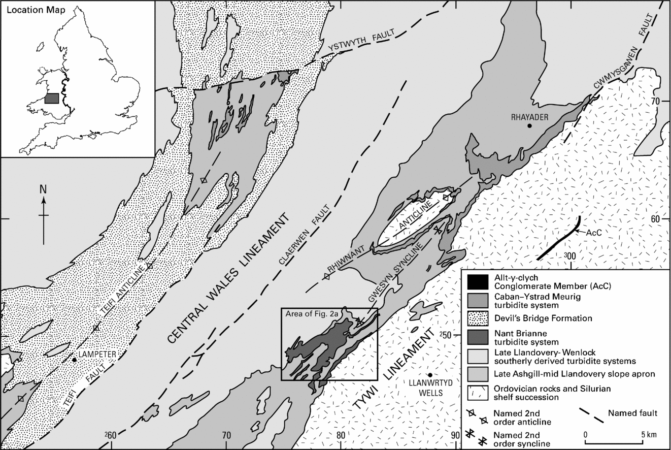
During deposition of the latest Ashgill to middle Llandovery series, between around 445 and 430 Ma (after Melchin, Cooper & Sadler, Reference Melchin, Cooper, Sadler, Gradstein, Ogg and Smith2004), the southern Welsh Basin recorded the development of a broad NW-facing slope apron, constructed principally from turbiditic and hemipelagic mudstones supplied from the east (Ball et al. Reference Ball, Davies, Waters and Zalasiewicz1992; Davies et al. Reference Davies, Fletcher, Waters, Wilson, Woodhall and Zalasiewicz1997), that extended west from the Tywi Lineament, a contemporaneous structural high separating basinal and shelfal domains (Fig. 1; Woodcock, Reference Woodcock1984). Locally punctuating this mudstone-dominated succession are several small-scale bodies of conglomerate and sandstone turbidites, also sourced from the east (Fig. 1; Morton et al. Reference Morton, Davies and Waters1992). These define narrow submarine corridors via which coarse clastic sediment was routed across the proximal parts of the slope apron, as well as lobe-like constructional features of similar material on the slope apron surface (Cave & Hains, Reference Cave and Hains1986; Davies & Waters, Reference Davies, Waters, Pickering, Hiscott, Kenyon, Lucci and Smith1995). As with many modern systems (e.g. Pickering, Hiscott & Hein, Reference Pickering, Hiscott and Hein1989), the confined nature of the proximal parts of these coarse-grade sediment bodies suggests a point source that was linked, via the adjacent shelf, to a contemporary fluvial system.
Geological sketch map of part of Central Wales, illustrating the location and setting of the late Ordovician to early Silurian basinal coarse clastic sequences considered herein. Box illustrates area shown in Figure 2a. Inset shows location of study area in southern Britain. Coordinates use the British National Grid and lie within the 100 km square SN.

The changes in facies architecture and depositional style of these turbidite systems are thought to reflect tectonically and eustatically driven sea-level changes (e.g. Davies et al. Reference Davies, Fletcher, Waters, Wilson, Woodhall and Zalasiewicz1997). Unravelling these influences provides insights into the nature and timing of both palaeo-plate interactions (e.g. Cocks & Torsvik, Reference Cocks and Torsvik2002) and global climatic variation during Early Palaeozoic times (e.g. Loydell, Reference Loydell1998; Page et al. Reference Page, Zalasiewicz, Willams, Popov, Williams, Haywood, Gregory and Schmidt2007 and references therein).
Tectonically driven sea-level changes in the Welsh Basin were controlled by oblique terminal collision of the palaeocontinents of Baltica, Laurentia and Avalonia, marked in the Welsh Basin by transtensional basin development that came to an end with the final excision of the Iapetus Ocean at around 420 Ma (Soper & Woodcock, Reference Soper and Woodcock2003). Dynamic changes in overall basin geometry during this period led to episodic intrabasinal uplift and subsidence, local compartmentalization and switching of sediment source areas and supply routes (e.g. Woodcock et al. Reference Woodcock, Butler, Davies, Waters, Hesselbo and Parkinson1996; Davies et al. Reference Davies, Fletcher, Waters, Wilson, Woodhall and Zalasiewicz1997). Eustatic sea-level changes are thought to have been strongly influenced by the development of an ice sheet on the main Gondwanan palaeocontinent, which was located at high latitudes in the southern hemisphere during Late Ordovician and Early Silurian times (e.g. Loydell, Reference Loydell1998; Cocks & Torsvik, Reference Cocks and Torsvik2002). Advance and retreat of land-based ice sheets is thought to have produced significant changes in sea level (e.g. Brenchley, Reference Brenchley1988; Page et al. Reference Page, Zalasiewicz, Willams, Popov, Williams, Haywood, Gregory and Schmidt2007).
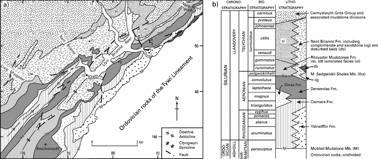
This paper presents a new stratigraphic and architectural description of a previously unrecognized coarse-grained turbidite corridor, located to the NW of the town of Llanwrtyd Wells in Powys (Fig. 1), and herein termed the Nant Brianne turbidite system (Fig. 2a, b; Schofield et al. Reference Schofield, Davies, Waters, Wilby, Williams and Wilson2004; Davies et al. Reference Davies, Schofield, Sheppard, Waters, Williams and Wilson2006). Interpretation of the system's evolution is considered in the context of previously described examples, and the interaction of contemporary tectonic, local- and global-scale base level changes. Together, these highlight the importance of differentiating eustatic and tectonic effects on base level when interpreting the stratigraphic architecture of ancient turbidite systems.
(a) Geological map illustrating the Nant Brianne turbidite system and host slope apron succession (after BGS, 2005, 2006). Numbered points refer to selected, dated graptolite localities detailed in Table 1. LF – Lynn Brianne Fault. (b) Schematic vertical section and key to ornaments and symbols in (a).

2. Stratigraphic context
The salient features of the Ashgill to middle Llandovery submarine slope apron succession, represented as a schematic vertical section in Figure 2b, have been described in detail by Davies et al. (Reference Davies, Fletcher, Waters, Wilson, Woodhall and Zalasiewicz1997; see also Schofield et al. Reference Schofield, Davies, Waters, Wilby, Williams and Wilson2004; Davies et al. Reference Davies, Schofield, Sheppard, Waters, Williams and Wilson2006). In summary, this succession comprises an alternation between anoxic facies, comprising dark grey turbidite mudstones interlayered with prominent laminated hemipelagic mudstones (Cwmere Formation and Monograptus sedgwickii Shales Member) and oxic facies, of pale green-grey, strongly burrow mottled turbidite mudstone and hemipelagite (Mottled Mudstone Member, Derwenlas Formation and Rhayader Mudstones Formation).
Two contemporaneous, late Hirnantian to early Telychian, laterally derived, coarse clastic turbidite systems, the Caban–Ystrad Meurig system and Allt-y-clych Conglomerate, have been described to date (Fig. 1). The most extensive of these, the Caban–Ystrad Meurig system, crops out on the NW margin of the Tywi Lineament near the town of Rhayader, and is represented by a coeval succession exposed in the core of the Teifi Anticline (Lapworth, Reference Lapworth1900; Jones, Reference Jones1922; Kelling & Woollands, Reference Kelling, Woollands and Wood1969; Davies & Waters, Reference Davies, Waters, Pickering, Hiscott, Kenyon, Lucci and Smith1995; Davies et al. Reference Davies, Fletcher, Waters, Wilson, Woodhall and Zalasiewicz1997; J. Holroyd, unpub. Ph.D. thesis, Univ. of Wales, Swansea, 1978). It was active from latest Ordovician (late Hirnantian) to early Telychian times and is interpreted as recording the deposition of a series of small, unconfined distributory fans (Ystrad Meurig Grits), supplied by a narrow channel–overbank system (Caban Conglomerate: Davies & Waters, Reference Davies, Waters, Pickering, Hiscott, Kenyon, Lucci and Smith1995; Davies et al. Reference Davies, Fletcher, Waters, Wilson, Woodhall and Zalasiewicz1997; Davies, Waters & Copus, Reference Davies, Waters and Copus1999). The Allt-y-clych Conglomerate (Andrew, Reference Andrew1925), contained within the Rhuddanian proximal slope apron sequence, is preserved along the eastern margin of the Tywi Lineament and comprises a thin sequence that may link with the Caban–Ystrad Meurig system (Davies et al. Reference Davies, Fletcher, Waters, Wilson, Woodhall and Zalasiewicz1997; Davies, Waters & Copus, Reference Davies, Waters and Copus1999).
The early Telychian parts of the Caban Conglomerate Formation, which post-date the Ystrad Meurig Grits, formed one of several supply routes to the early parts of the Devil's Bridge Formation (Davies et al. Reference Davies, Schofield, Sheppard, Waters, Williams and Wilson2006), a turbidite system, up to 600 m in thickness, that blanketed much of the basin west of the Central Wales Lineament during early to middle Telychian times (Cave & Hains, Reference Cave and Hains1986; Davies et al. Reference Davies, Fletcher, Waters, Wilson, Woodhall and Zalasiewicz1997; James, Reference James2005).
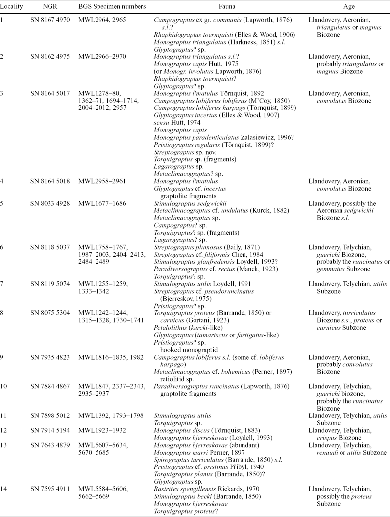
Recent surveying by the British Geological Survey in the Builth Wells and adjacent Lampeter districts has revealed another broadly contemporaneous, easterly derived, coarse clastic turbidite system, transecting the same slope apron succession as the Caban–Ystrad Meurig system (Davies et al. Reference Davies, Fletcher, Waters, Wilson, Woodhall and Zalasiewicz1997). It is located on the NW flank of the Tywi Lineament, centred on the Llyn Brianne dam [SN 795 485] (Schofield et al. Reference Schofield, Davies, Waters, Wilby, Williams and Wilson2004; Davies et al. Reference Davies, Schofield, Sheppard, Waters, Williams and Wilson2006). The main depositional unit, the Nant Brianne Formation, takes its name from one of the tributaries to the SW arm of the reservoir, but the Nant Brianne turbidite system, as defined here, includes additional, sandstone-rich units and flanking facies also present in the vicinity (Fig. 2). Anoxic horizons within the succession favour preservation of graptolites. These have been used to provide a detailed biostratigraphic framework for the architecture of the Nant Brianne system. Key localities and ages are listed in Table 1 and plotted on Figures 2a and 3.

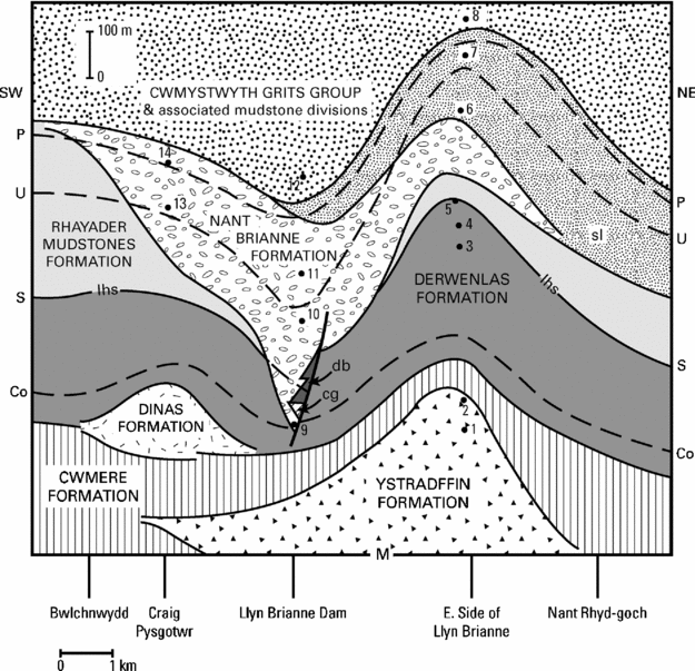
Cartoon illustrating the architecture of the Nant Brianne Formation and associated coarse clastic lenses. Indicative bases of selected biozones are shown as are selected graptolite localities, detailed in Table 1. Co – convolutus graptolite Biozone; S – sedgwickii graptolite Biozone; U – utilis Subzone (turriculatus Biozone); P – proteus Subzone (turriculatus graptolite Biozone). See Figure 2b for key to ornaments, symbols and chronostratigraphic relationships of the biozones.

Coarse clastic sediments were first recognized in this area by K. A. Davies (Reference Davies1933). Mackie (A. H. Mackie, unpub. Ph.D. thesis, Univ. Cambridge, Reference Mackie and Smallwood1987, Reference Mackie, Woodcock and Bassett1993; see also Mackie & Smallwood, Reference Mackie and Smallwood1987) did not distinguish the Nant Brianne Formation sand body as a separate unit and included the equivalent strata principally in his Cefn Isaf and Llyn Brianne formations, but also locally in his Hafdre Formation; the latter has been shown to include rocks now recognized as part of the overlying, southerly sourced Cwmystwyth Grits Group (Davies et al. Reference Davies, Schofield, Sheppard, Waters, Williams and Wilson2006). Nevertheless, much of the palaeocurrent and other directional data cited below concur with Mackie's findings.
3. Nant Brianne turbidite system
The main architectural features of the Nant Brianne system and its relationship with the enveloping slope apron succession are illustrated in Figure 3. As this system has not previously been described, sedimentological features of the component successions are presented in Appendix 1. The system rests locally on the basal Mottled Mudstone Member of the Cwmere Formation, which is of persculptus graptolite Biozone age, and provides an important stratigraphic datum. Beneath the Nant Brianne Formation, separate and in part older elements of the system comprise two sandstone-rich units here named the Ystradffin and Dinas formations. Upper levels of the Nant Brianne Formation pass laterally into a distinctive siltstone-rich flanking facies included in the Rhayader Mudstones Formation and are succeeded by divisions of the southerly sourced Cwmystwyth Grits Group (Schofield et al. Reference Schofield, Davies, Waters, Wilby, Williams and Wilson2004; Davies et al. Reference Davies, Schofield, Sheppard, Waters, Williams and Wilson2006).
3.a. Ystradffin Formation
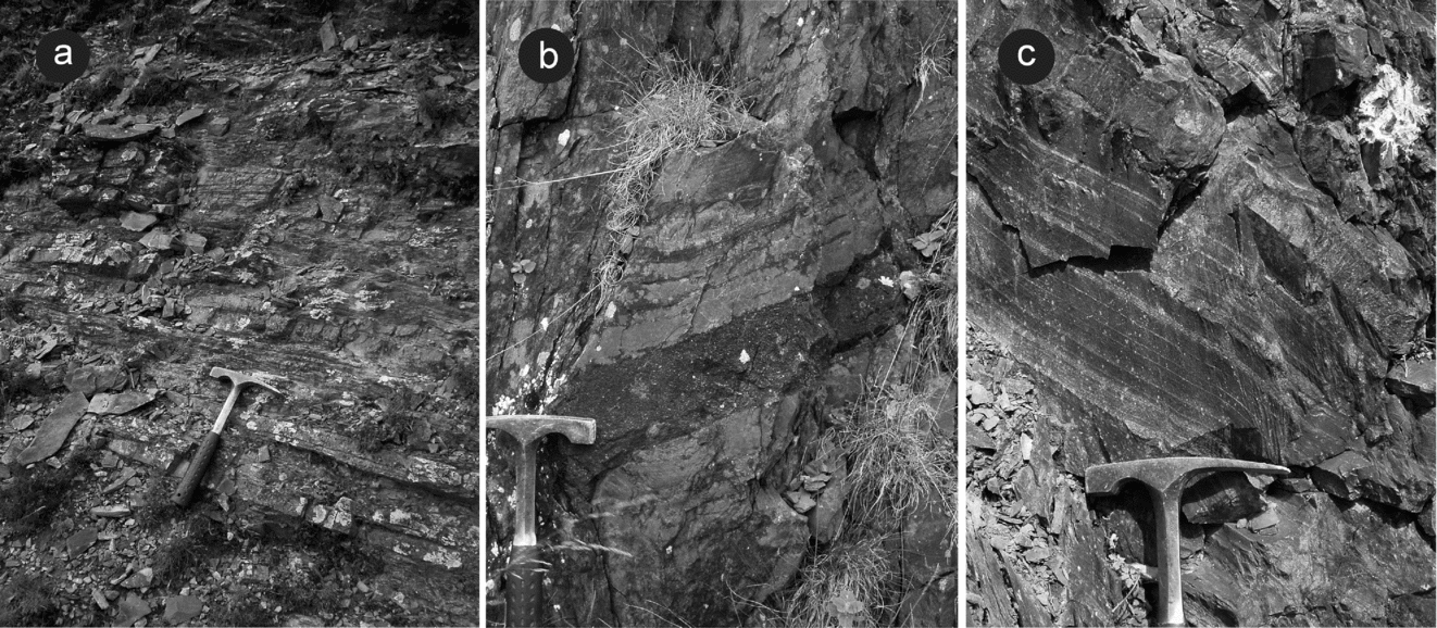
This newly named division ranges from latest Ordovician (Hirnantian) to early Aeronian age and comprises up to 350 m of thinly interbedded sandstones and mudstones arranged in Bouma (Reference Bouma1962) turbidite sequences (Fig. 4a). Lower levels of the formation succeed the Mottled Mudstone Member. In the axis of the system, upper levels of the formation yield probable triangulatus graptolite Biozone assemblages (locality 2). Palaeocurrent vectors from the formation range from WSW to ENE, but are dominantly N- to NW-directed.
Field photographs showing: (a) Bouma turbidite sandstone–mudstone couplets, thicker beds display Tb–c sequences, thinner beds exclusively Tc divisions, road cutting [SN 817 496], Ystradffin Formation. (b) Bouma turbidite sandstone–mudstone couplets; note coarse-grained sandstone Ta division (by hammer head) rich in shell debris, Llyn Brianne dam access road [SN 793 483], Nant Brianne Formation. (c) Bouma turbidite sandstone–mudstone couplets; note basal, loaded-ripple Tc division to left of hammer and planar-laminated Td divisions at base of mudstone-dominated couplets, Llyn Brianne dam access road [SN 793 482], basal Nant Brianne Formation. Hammer for scale is ~0.28 m long.

3.b. Dinas Formation
This spatially separate sandstone-rich sequence comprises up to 200 m of thinly interbedded turbidite sandstones and mudstones, laterally equivalent in its lower half to the adjacent Cwmere Formation. In contrast, burrowed hemipelagites and the presence of trace fossil casts on the bases of the sandstones show the upper part, up to 150 m, of the formation to be oxic and coeval with the enveloping Derwenlas Formation. No graptolite faunas have been recovered from the Dinas Formation, but its stratigraphic relationship with the enveloping sediments support an early to middle Aeronian age, with marked lateral expansion of its oxic portion initiated in the late magnus graptolite Biozone.
3.c. Nant Brianne Formation
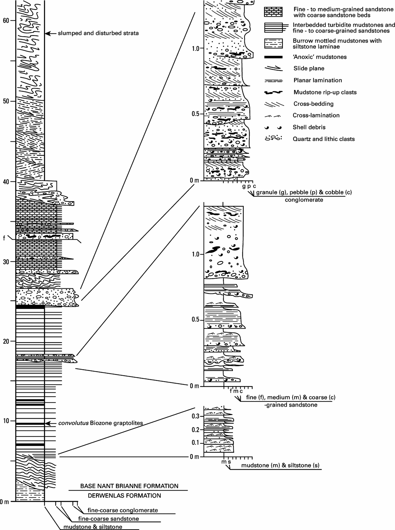
The Nant Brianne Formation, which crops out in the vicinity of the Llyn Brianne reservoir and dam [SN 795 485] (Fig. 2), ranges up to 410 m in thickness and records the middle Aeronian to middle Telychian evolution of the Nant Brianne turbidite system. The oldest (Aeronian) parts of the formation are confined within a narrow central zone located immediately to the west of the Llyn Brianne Fault. In this part of the succession, the formation contains units of turbidite conglomerate, and slumped strata (Figs 4b, 5), which pass laterally into interbedded turbidite sandstones and mudstones arranged in Bouma-type couplets (Figs 4c, 5). However, the base of the formation is strongly diachronous, and during Telychian times a rapid lateral expansion occurred outwards from this central area (Fig. 3). In the upper part of the system, thinly interbedded turbidite sandstones and mudstones are interlayered with subordinate mudstone-dominated intervals, closely comparable to adjacent slope apron facies. Much thinner sequences occupy these western and eastern ‘wings’, but at their maximum, these younger levels of the formation occupy a 9 km wide belt. Palaeocurrent measurements in the vicinity of the Llyn Brianne Fault, including pebble orientations (after A. H. Mackie, unpub. Ph.D. thesis, Univ. Cambridge, Reference Mackie and Smallwood1987), indicate turbidity current flow mainly towards the NW, consistent with those for the formation as a whole. Slump fold axes in the adjacent disturbed sequence are oriented parallel to the NW-trending fault.
Graphic log of the lower part of Nant Brianne Formation as exposed in a continuous cutting on the eastern side of the Llyn Brianne dam access road between [SN 793 482] and [SN 793 484].

4. Discussion
4.a. Local controls on turbidite system evolution
The Nant Brianne system records the influence of sea-floor topography on localizing deposition. In the lowest part of the system, Mackie (A. H. Mackie, unpub. Ph.D. thesis, Univ. Cambridge, Reference Mackie and Smallwood1987) envisaged his Clyn-glas Formation (approximately equivalent to the Ystradffin Formation of this account) as infilling a broad hollow, either a slump scar or a channel, formed during the late Ordovician fall in sea level. However, he did not recognize the presence of the Mottled Mudstone Member as a continuous datum beneath the Ystradffin Formation, which indicates that the latter shows no erosion at the base, and instead formed a positive, constructional feature on the contiguous slope apron surface (Fig. 3). The Dinas Formation may mark the site of a smaller, younger lobe, the location of which, offset to the south, was in part determined by the relief created by the earlier Ystradffin feature (cf. Davies & Waters, Reference Davies, Waters, Pickering, Hiscott, Kenyon, Lucci and Smith1995).
The early (Aeronian) part of the Nant Brianne Formation records a period of laterally confined sand and gravel deposition. Graptolites of the convolutus graptolite Biozone (locality 9) from within the formation and from anoxic levels within the Derwenlas Formation to the east of the Llyn Brianne Fault (localities 3 and 4) attest to dramatic lateral facies change across the fault and confirm that it formed a significant topographic feature at this time. It was thus probably instrumental in confining and accommodating the late Aeronian evolution of the Nant Brianne Formation. The relief created by the earlier Ystradffin and Dinas features, and a localized depocentre created by a probable linear half-graben formed by movement on the Llyn Brianne Fault (Fig. 3), were clearly instrumental in locating a narrow corridor in which gravels were deposited from high-concentration, surging and bottom-hugging turbidity flows (e.g. Pickering, Scott & Hein, Reference Pickering, Hiscott and Hein1989; Hein & Walker, Reference Hein and Walker1982). This channelized belt was subsequently occluded or displaced by the foundering of adjacent slope apron muds along the active fault scarp.
The earliest parts of the Nant Brianne Formation east of the Llyn Brianne Fault overlie the Monograptus sedgwickii Shales Member and record the overtopping of the fault scarp, ending its role as a confining structure sometime during the Late Aeronian to Early Telychian (Fig. 3). The rapid expansion of the Nant Brianne Formation during Telychian times may record the re-establishment and advance of a lobe-like body above the earlier channelized units. However, it remained partially confined on its eastern flank, suggesting that deposition of this part of the formation was still influenced by sea-floor relief created previously by the Llyn Brianne Fault.
4.b. High order eustatic controls
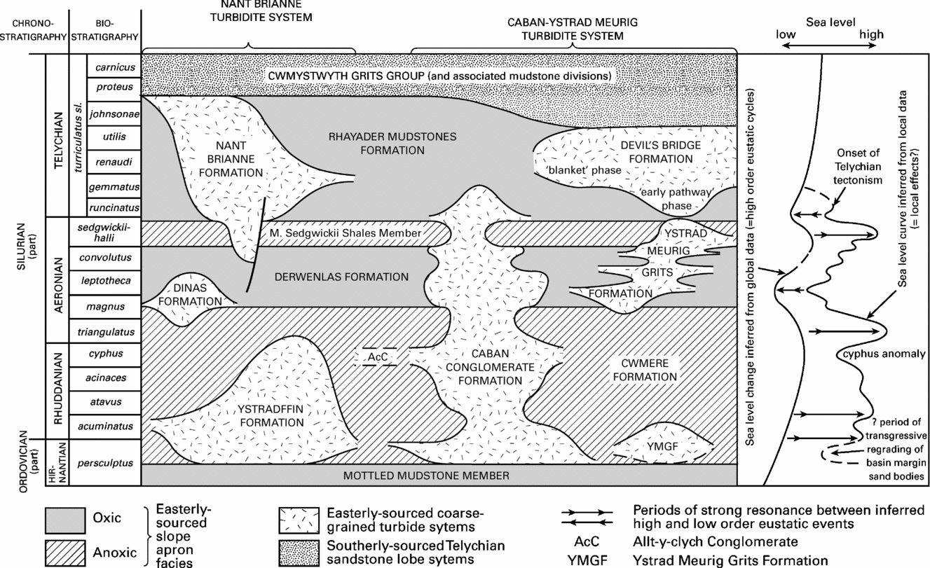
Figure 6 illustrates the biostratigraphic range and lateral extent of the various Rhuddanian to Telychian coarse clastic bodies, relative to the slope apron sequence in which they are embedded. Within the slope apron sequences, the alternation of oxic and anoxic intervals may in some instances record key eustatic events of the late Hirnantian to early Telychian period, many of which may relate to the retreat and advance of a fluctuating Gondwanan ice sheet (Page et al. Reference Page, Zalasiewicz, Willams, Popov, Williams, Haywood, Gregory and Schmidt2007). In Central Wales, two main transgressive–regressive cycles, defining two major sedimentary sequences, are recognized. The principal events and the local slope–apron responses were as follows:
(1) An initial late Hirnantian to Rhuddanian age major post-glacial rise in sea level which established anoxic slope apron conditions. This transgression was sustained throughout Rhuddanian times with a consensus that maximum flooding was achieved during the cyphus graptolite Biozone (e.g. Johnson, Kaljo & Rong, Reference Johnson, Kaljo, Rong, Bassett, Lane and Edwards1991).
(2) An early Aeronian regression which introduced oxic slope apron facies. There is growing evidence to suggest that this event had its acme at or around the magnus–leptotheca biozonal boundary (e.g. Loydell, Reference Loydell1998).
(3) A late Aeronian transgression (or transgressions). An analysis of global data (Page et al. Reference Page, Zalasiewicz, Willams, Popov, Williams, Haywood, Gregory and Schmidt2007) suggests that a global marine transgression occurred at the time of the convolutus graptolite Biozone, corresponding with thin units of anoxic facies mudstones of this age, recognized in the slope apron succession of the Welsh Basin (Davies et al. Reference Davies, Fletcher, Waters, Wilson, Woodhall and Zalasiewicz1997). However, within the basin and on its contiguous shelf, together with records from other basinal successions from the Iapetus–Rheic ocean margin of Gondwana, there is clear evidence of a more marked and rapid rise in sea level around the start of the succeeding sedgwickii graptolite Biozone (Page et al. Reference Page, Zalasiewicz, Willams, Popov, Williams, Haywood, Gregory and Schmidt2007 and references therein). The eustatic nature of this event is questioned (Page et al. Reference Page, Zalasiewicz, Willams, Popov, Williams, Haywood, Gregory and Schmidt2007), but on the local slope apron it is clearly recorded by the widespread Monograptus sedgwickii Shales anoxic interval which correlates, at least in part, with an overstepping, Pentamerus-bearing sandstone bed in adjacent shelf sequences (Davies et al. Reference Davies, Fletcher, Waters, Wilson, Woodhall and Zalasiewicz1997; Schofield et al. Reference Schofield, Davies, Waters, Wilby, Williams and Wilson2004).
(4) Global data provide evidence of a possible glacially induced regression during the sedgwickii graptolite Biozone. In the Welsh Basin, resumption of oxic slope apron deposition above the Monograptus sedgwickii Shales Member was perhaps the local response to this event. Predominantly oxic deposition, as recorded by the Rhayader Mudstones, was sustained throughout much of the ensuing early Telychian interval, but conflicts with evidence of rising global sea level at this time (Davies et al. Reference Davies, Fletcher, Waters, Wilson, Woodhall and Zalasiewicz1997).
Regional architecture illustrating the biostratigraphic range and relative lateral extent of the Nant Brianne and Caban–Ystrad Meurig systems relative to the host slope apron succession.

The geometry of the sand-rich systems reveals trends that are at odds with obvious eustatic influences. In particular, the outbuilding of lobes of sand-rich sediment during late Hirnantian to early Rhuddanian times (persculptus to acuminatus graptolite biozones), as represented by the Ystradffin Formation of the Nant Brianne system, and the Cerig Gwynion Grits of the Caban–Ystrad Meurig system, occurred during rapidly rising sea level. Although these may in part reflect higher frequency, lower order eustatic controls (see next Section), an alternative explanation for this is that these bodies are analogous to the ‘slope front fills’ identified on seismically imaged slope apron successions (e.g. Mitchell et al. Reference Mitchell, Beamish, Wood, Malecek, Armentrout, Damuth, Olson and Parker1993), and may record the reworking and basinward transport of sand previously carried onto the adjacent shelf during the preceding glacio-eustatic lowstand.
A comparable situation occurred with the expansion of the Caban–Ystrad Meurig system to its greatest lateral extent during a period of sea-level highstand, coincident with the cyphus graptolite Biozone (Davies & Waters, Reference Davies, Waters, Pickering, Hiscott, Kenyon, Lucci and Smith1995). This expansion was accompanied by deposition of the Allt-y-clych Conglomerate and continued sedimentation in the Ystradffin tract.
A significant reduction of sediment input into both turbidite systems, which began in the late cyphus graptolite Biozone and lasted into the triangulatus graptolite Biozone, could reflect the delayed influence of the global transgression on sediment supply (see next Section). Certainly, the marked expansion during the succeeding magnus graptolite Biozone in both the Dinas and Caban Conglomerate formations, coinciding with the onset of oxic conditions across the adjacent slope apron (base Derwenlas Formation), can be interpreted as a response, at least in part, to the early Aeronian eustatic regression.
4.c. Low order eustatic controls
The coarse grade and large volume of clastic material supplied to the Nant Brianne and Caban–Ystrad Meurig systems, at times of eustatic sea-level rise, appears to support the suggestion that the detritus was generated in response to tectonic uplift in sediment source areas sited to the east of the basin (Woodcock et al. Reference Woodcock, Butler, Davies, Waters, Hesselbo and Parkinson1996; Davies et al. Reference Davies, Fletcher, Waters, Wilson, Woodhall and Zalasiewicz1997). However, Davies, Waters & Copus (Reference Davies, Waters and Copus1999) recognized a close comparison with the architectural elements of many hydrocarbon-bearing deep-water basins, such as that described by Mitchell et al. (Reference Mitchell, Beamish, Wood, Malecek, Armentrout, Damuth, Olson and Parker1993) for the Palaeocene of the Faeroe Basin. There, each episode of turbidite system expansion is correlated with a minor marine regression. Assuming that the patterns of sediment input are driven exclusively by base level changes and not variations in supply and/or the rate of subsidence, application of this model to the turbidite systems examined in this paper implies that a series of lower order events (Fig. 6), which influenced the flux of coarse-grade detritus entering the basin, were superimposed on the major eustatic cycles. When there was concordance between the smaller and larger eustatic cycles, typically ascribed to orbital forcing (e.g. Fischer & Bottjer, Reference Fischer and Bottjer1991), the sediment supply could be predicted to be either especially high or low (Van Wagoner et al. Reference Van Wagoner, Mitchum, Campion and Rahmanian1990). The former was possibly the case during early Aeronian times, the latter during the sedgwickii Biozone.
The high levels of coarse clastic input during the cyphus graptolite Biozone at the height of the Rhuddanian post-glacial transgression remain an enigma. Viewed in isolation, it could be argued that this period of turbidite system expansion, as with the earlier Ystradffin and Cerig Gwynion Grits lobes, records the basinward transfer of sand and gravel as part of a re-grading of the shelf edge; furthermore, this would have taken place during the early phases of a lower order transgression (Ross et al. Reference Ross, Halliwell, May, Watts and Syvitski1994). However, coeval shelf successions also experienced increased levels of sand input at this time (Barclay et al. Reference Barclay, Davies, Humpage, Waters, Wilby, Williams and Wilson2005; Cocks et al. Reference Cocks, Woodcock, Rickards, Temple and Lane1984; Schofield et al. Reference Schofield, Davies, Waters, Wilby, Williams and Wilson2004), indicating that the pattern of deposition was controlled by marine regression. Subsequently, the global high sea-level conditions and a lower order base-level rise may have combined to abruptly limit the input of sediment during the marked triangulatus graptolite Biozone contraction.
4.d. Regional tectonic controls
The marked increase in the volume of sandy detritus supplied to the basin during deposition of the Telychian Series coincided with the onset of widespread tectonism throughout the basin and its hinterland (Woodcock et al. Reference Woodcock, Butler, Davies, Waters, Hesselbo and Parkinson1996), and contrasts with earlier, localized tectonic activity preserved in the Rhuddanian and Aeronian record of the basin margin (e.g. Woolhope and Usk basins: Woodcock et al. Reference Woodcock, Butler, Davies, Waters, Hesselbo and Parkinson1996; Butler, Woodcock & Stewart, Reference Butler, Woodcock and Stewart1997). Any evidence for the influence of eustatic events is lacking, and it is clear that the detritus entering the basin was, at this time, dominantly tectonically generated. The Telychian expansion of the Nant Brianne system coincided with a marked reduction of the Caban–Ystrad Meurig system, suggesting that the latter was replaced by the former as the principal point of supply to the ‘blanket phase’ of the Devil's Bridge Formation (Fig. 1; see Davies et al. Reference Davies, Fletcher, Waters, Wilson, Woodhall and Zalasiewicz1997). Faulting, both within the basin and along its margins, ultimately led to the abandonment of the Nant Brianne and Caban–Ystrad Meurig systems as their supply paths from the east were dislocated and the direction of sediment input to the basin switched to the south (Woodcock et al. Reference Woodcock, Butler, Davies, Waters, Hesselbo and Parkinson1996; Davies et al. Reference Davies, Fletcher, Waters, Wilson, Woodhall and Zalasiewicz1997, Reference Davies, Schofield, Sheppard, Waters, Williams and Wilson2006).
5. Conclusions
The newly recognized late Hirnantian to early Telychian Nant Brianne turbidite system represents a narrow corridor of laterally supplied, easterly sourced, coarse-grained deposits that punctuated a mudstone-dominated slope apron, along the SE margin of the southern Welsh Basin. Application of high-precision graptolite biostratigraphy has shown that its evolution, and that of coeval coarse-grained systems, was influenced by a number of factors, including sea-floor topography and synsedimentary faulting. However, the interaction of high order eustatic events, related to fluctuation of contemporary Gondwanan ice sheets, with lower order, lower magnitude sea-level changes, appears to have been a critical influence on sedimentary architecture prior to the onset and overriding influence of Telychian age regional tectonism.
Acknowledgements
This work was carried out as part of the BGS' Central Wales Rapid Mapping Project. The authors would like to thank Alex Page for access to a proof version of Page et al. (Reference Page, Zalasiewicz, Willams, Popov, Williams, Haywood, Gregory and Schmidt2007) and Stuart Molyneux for providing useful comments on an earlier version of this manuscript. D. I. Schofield, J. R. Davies and D. Wilson publish with the permission of the Executive Director, British Geological Survey. Mark Williams thanks the University of Leicester for study leave.
Appendix 1. Detailed description of rock units and facies
(see main text for additional data)
Ystradffin Formation. The formation attains its maximum thickness in its type area between Ystradffin Farm [SN 788 466] and an inlet of the Llyn Brianne Reservoir [SN 816 495] and passes laterally into the enveloping slope apron mudstone succession (Cwmere Formation). It extends laterally, along strike for a distance of 8.5 km and incorporates some of the sections described in detail by A. H. Mackie (unpub. Ph.D. thesis, Univ. Cambridge, 1987) and included in his Clyn Glas Formation (see also Mackie & Smallwood, Reference Mackie and Smallwood1987).
A single lithofacies of thin- to medium-bedded turbidite sandstones, interbedded with thin turbidite and hemipelagic mudstones was recognized within the formation (Fig. 4a). This is characterized by tabular sandstone beds, up to 0.3 m thick, that form the basal division of sandstone–mudstone couplets. Base-cut-out Tb–e and Tc–e sequences predominate (Bouma, Reference Bouma1962), while graded basal Ta divisions, including complete Ta–e sequences and top-cut-out Ta–b sequences, are rare. Turbidite mudstone (Te) intervals range up to 0.15 m in thickness. Many of the sandstones display convolute lamination. Sections in the east of the formation measured by Mackie (A. H. Mackie, unpub. Ph.D. thesis, Univ. Cambridge, 1987) include a series of small-scale (<10 m) thinning- and fining-upwards cycles. The thickest turbidite sandstone beds occur in the lower part of the formation, where the sandstone content ranges up to 60%.
Dinas Formation. The type locality of this unit are the crags south of the Afon Tywi [SN 774 458]. Laminated hemipelagites present in the lower, anoxic levels are restricted to the south of Dinas [SN 780 465], but the oxic portion is more widespread and forms the whole of the sandstone-rich sequence on, and to the north, of this prominent rock buttress. The oxic levels also crop out to the NW along both limbs of the Doethie Anticline (Fig. 2). Its geometry suggests that depositing turbidity currents flowed predominantly towards the NW.
The formation comprises a facies of thin-bedded turbidite sandstones, interbedded with thin turbidite and hemipelagic mudstones characterized by tabular and lenticular turbidite sandstones, up to 0.1 m thick that are typically planar- or cross-laminated and form part of turbidite sandstone–mudstone couplets (Tb–e and Tc–e; Bouma, Reference Bouma1962).
Nant Brianne Formation. Road cuttings to the east of the Llyn Brianne dam provide a section [SN 793 482] through the oldest (Aeronian) levels of the Nant Brianne Formation. At this stratigraphic level, the formation occupies a 2 km wide belt confined on its eastern side by the Llyn Brianne Fault. In the section adjacent to the dam access road (Fig. 5), a basal sequence of slumped and disturbed strata passes up into a 17 m thick unit of Bouma sandstone-mudstone couplets (Fig. 4c), including a thin unit with anoxic hemipelagites. These are overlain by a 3 m thick unit composed of medium to thick beds of turbidite conglomerate and pebbly sandstone (Fig. 4b). Conglomeratic facies are also seen in river cliffs [SN 480 785] to the SW of the Llyn Brianne dam. The conglomeratic beds of the access road section are succeeded by a sequence, up to 100 m thick, of slumped and disturbed strata (Figs 2, 3) that also occupies a narrow belt adjacent to the Llyn Brianne Fault. The mudstone-dominated parts of the disturbed sequence resemble the oxic slope apron facies which crop out to the east of the Llyn Brianne Fault.
The upper (Telychian) part of the Nant Brianne Formation comprises rhythmically interlayered thin- to medium-bedded turbidite sandstones and mudstones. The lower part of this sequence comprises about 50% sandstone with individual beds up to 0.5 m thick. Above this the sequence comprises a crudely thinning- and fining-upwards succession in which the sandstone content diminishes to as little as 10%. Packets of strata essentially identical to enveloping slope apron facies are also present throughout the upper part of the formation. This part of the sequence crops out between the Llyn Brianne Reservoir and Craig Pysgotwr, occupying both limbs of the Doethie Anticline and the core of the Cilgwyn Syncline (Fig. 2). The eastern ‘wing’ of the formation extends some 5 km beyond the fault and ranges up to 200 m in thickness. Traced NE toward Nant Rhyd Goch it becomes thinner and its base younger, and its upper parts pass laterally into a distinctive siltstone-laminated facies of the Rhayader Mudstones that has yielded graptolites of early to middle Telychian (turriculatus graptolite Biozone) age (localities 6 and 7). To the SW, between Llyn Brianne dam and Bwlchnewydd, the base of the formation is diachronous above the datum of the Monograptus sedgwickii Shales Member and represents part of a SW expansion of the system which mirrors that to the east (Fig. 3). Early to middle Telychian turriculatus Biozone graptolites have been recovered from anoxic hemipelagites preserved within this western ‘wing’, on Craig Pysgotwr (localities 13 and 14).
The Nant Brianne Formation comprises three sedimentary lithofacies:
(a) The confined lower part of the formation predominantly comprises medium- to thick-bedded turbidite conglomerate and pebbly sandstone. The conglomerates are poorly sorted and include well-rounded clasts, up to 0.1 m in diameter, composed of vein quartz, igneous and sedimentary rock types, in a matrix of coarse-grained sandstone; mudstone rip-up clasts, abraded and broken shelly fossils, including corals, are common. Normally graded beds above a locally channelized base record the rapid deposition from high concentration gravel-laden gravity flows (R3; Lowe, Reference Lowe1982). Rare cross-stratification (S1) and planar lamination (S2) visible in the sandier upper parts of some beds indicate tractional processes that were operative during the later phases of deposition, but structureless sandstone intervals (S3) that were deposited from suspension are more common. At the margins of this facies a basal conglomerate layer, commonly rich in shell debris, is succeeded by an upward-fining sandstone displaying well-developed planar- and cross-laminated divisions (Ta–c).
(b) Disturbed beds, which succeed the conglomeratic facies in the vicinity of the Llyn Brianne Fault, comprise a lower unit of highly contorted and disrupted mudstones, with isolated pillows of conglomerate and sandstone, and a thicker upper unit of slump-folded and destratified mudstone which displays abundant evidence of small-scale synsedimentary faulting and down-slope sliding (Mackie & Smallwood, Reference Mackie and Smallwood1987).
(c) The bulk of the formation comprises thin- to medium-bedded turbidite sandstones interbedded with thin turbidite and hemipelagic mudstones. In this facies, some of the thicker sandstone beds form part of complete Bouma sequences (Ta–e), in which the normally graded and coarser-grained Ta division commonly infills shallow scours, but most of the sandstones are tabular, medium- to fine-grained, and display planar-laminated (Tb) and/or cross- or convolute-laminated (Tc) intervals. Siltstone laminae (Td) are commonly present at the base of the succeeding mudstone Te division. Many of these beds contain fine shell debris and preserve the casts of trace fossils, together with tool marks and groove casts on the bases of most beds, although flute casts are less common. In the upper levels of this sequence, the sandstone/mudstone couplets predominantly comprise Tc–e sequences. Planar-laminated Tb divisions are rare and Ta divisions are absent. Turbidites composed exclusively of the mudstone Te division, with or without a basal Td interval, increase in importance and are the principal component of thin, mudstone-dominated packets in the uppermost parts of the formation. Many of these include a basal, cross- and planar-laminated siltstone interval, display the features described by Stow & Piper (Reference Stow, Piper, Stow and Piper1984) and are the product of deposition from very low concentration turbidity currents.