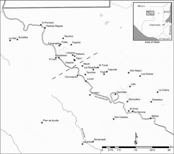
Over the course of the Classic period, from about a.d. 350 to 900, the rulers of Maya polities in the Usumacinta River Basin sought to expand the range of their authority and the integrity of their territorial control. For the rulers of the kingdoms centered on what are now the archaeological sites of Piedras Negras, Guatemala, and Yaxchilan, Mexico, this expansive power was achieved in no small part through patron-client relationships with subsidiary noble lords who patrolled and controlled the boundaries of their territories (Figure 1). Throughout most of the Classic period, public monuments and the inscriptions they bore were the sole prerogative of royal personages. But by the Late Classic period (ca. a.d. 600–900) the power and authority of client lords had grown such that they were accorded their own inscribed monuments. These monuments together with associated ritual performance must have formed an integral part of the construction of history and collective memory for multiple social segments within the kingdom.
Map of the region showing the regional capitals of Piedras Negras and Yaxchilan as well as subordinate centers mentioned in text. Dashed line shows hypothetical border between the two kingdoms. Site indicated as Plan de Ayutla may be the capital of the Sak Tzi' kingdom (Biró Reference Biró2005; Martin and Grube Reference Martin and Grube2008:146). Map by Charles Golden.

As the complexity of the political system grew, this dissemination of authority to shape official history and transform social memory increased the potential for signs of royal authority to be contested through competing historical narratives. Rather than merely reflecting a polity-wide history, the increasing presence of the subordinate nobility in public performances of memorialization raised the possibility for these nobles to use architecture, texts, and ritual performances to re-create history and shape collective social memory in their own image and for their own interests. In the limited space provided in this forum, I will briefly outline my understanding of social memory as a political tool, and I will illustrate with just a few examples how the governors of secondary political centers along the boundaries of the Piedras Negras and Yaxchilan kingdoms might have challenged royal authority by reshaping social memory and how paramount rulers may have acted to restrain them.
SOCIAL MEMORY: A DEFINITION OF TERMS
Before I address the data I must clarify my use of several terms. First and foremost, I use the terms social memory and collective memory interchangeably throughout this paper. Maurice Halbwachs (Reference Halbwachs1992 [1925]:43) contends that “[n]o memory is possible outside frameworks used by people in society to determine and retrieve their recollections.” I would alter this slightly and say that individual memory is possible on the basis of unique sensory experiences. People are not born with “social” or “collective” memory, but (except in those rare cases when wayward children are raised by wolves) people begin to make sense of those memories and learn to express effectively and communicate an understanding of the world in terms of those memories by interacting socially with other people.
Of course, individuals within the group may retain and recall very different memories. Collective memory, in a critical sense, must be understood as shared individual memory (Hirst and Manier Reference Hirst and David2008:186), and the transmission of memories among members of the group inherently entails changes in the significance of those memories (Meskell Reference Meskell, Van Dyke and Alcock2003:36). But if we are to make sense of ourselves to others, the memories of things past that structure our present necessarily include and express a sense of the corporate (Connerton Reference Connerton1989:1). Indeed, for collective memory to exist there must be convergence of individual remembrances such that some sort of coherent narrative about the group emerges (Hirst and Manier Reference Hirst and David2008:193–194).
In contrast to memory, I consider “history” to be the attempt, successful or otherwise, to codify and direct collective memory in some durable media, such as text, architecture, or art. History is created, enacted, and shaped for the political purpose of excluding other narratives of memory (Olick and Robbins [1998] offer a useful summary of variable usage of these terms). Here I differ with Halbwachs, Pierre Nora, and others scholars who have treated memory as living and dynamic while considering history essentially dead and static.
For Halbwachs (Reference Halbwachs1980 [1925]:78), “collective memory is not the same as formal history … [G]eneral history starts only when tradition ends and the social memory is fading or breaking up”. For Nora (Reference Nora1989), memory is a living dialogue about the past between members of a community, and as such is open to debate, contestation, forgetting, and manipulation. History, on the other hand, is a static and incomplete reconstruction of a past that is not otherwise maintained by a community. “History's goal and ambition is not to exalt but to annihilate what has in reality taken place” (Nora Reference Nora1989:9); it is dead, while memory is alive (Cattell and Climo Reference Cattell, Climo, Climo and Cattell2002:6).
Robert Archibald (Reference Archibald, Climo and Cattell2002:69) further teases out the perceived implications of history's static reconstruction of the past: History is conceptually “factual” and thus more correct than memory, which is a malleable perception of the past. This separation of memory from history is interpreted by many scholars to be part of the modern experience. According to Jacob Cattell and Maria Climo (Reference Cattell, Climo, Climo and Cattell2002:6), following Nora and others, there has been a “crisis of memory” in the twentieth and twenty-first centuries. The past as remembered has been severed from life as lived, and the past has thus moved over the threshold from memory into history.
I believe instead that such dramatic distinctions between living memory and dead history (as between pre-modern, modern and post-modern) overstate the divide and miss the important point that history is neither static nor closed to debate. Rather, there remains a vast storehouse of public recollections that remains in the “mode of potentiality,” and which may become relevant in any given present (Assmann Reference Assmann1995:130; Kansteiner Reference Kansteiner2002:182–183). A changing social or political situation may bring to the surface memories long suppressed or seemingly erased by public histories, even in modern societies (Aguilar Reference Aguilar and Olick2003; Corney Reference Corney and Olick2003; Zerubavel Reference Zerubavel and Olick2003). History cannot completely erase or replace memory until dramatic changes occur such that there is a complete social and cultural disconnection from that which came before, or until such time as a particular discourse of memory loses relevance to all members of a population (Blake Reference Blake, Van Dyke and Alcock2003; Meskell Reference Meskell, Van Dyke and Alcock2003).
Thus, for the modern viewer, the inscriptions on Classic Maya monuments would constitute history in the sense that Nora (Reference Nora1989) and Halbwachs (Reference Halbwachs1980 [1925]) intend. We are too disconnected from the events recorded on these monuments to call them memory. As objects and texts in and of themselves they may become part of the collective memory for many modern groups, including archaeologists, indigenous groups, and nation states, among others, but they will not function as they did in the society for which they were produced.
In trying to understand inscriptions and their roles as acts of memorialization, however, the distinction between memory and history developed by Nora, Halbwachs, and their academic descendants is not applicable to the Classic Maya. If there was, in fact, a “crisis of memory” in the twentieth century (and I am not convinced that there was), the ancient Maya did not pass through it. Furthermore, for the Classic Maya the texts and imagery on monuments, which represent our best access to those data typically glossed as “history,” the distinction between life as remembered (as expressed on those monuments) and life as lived may not have been pertinent. If one accepts Stephen Houston and David Stuart's (Reference Houston and Stuart1998; Stuart Reference Stuart1996) interpretation of Maya imagery and text on stone monuments, the individuals and events portrayed are to be understood as beings and doings that are in process. That is to say they have not passed on into a stultified history but are rather part of life as it is being lived. They are not static but are in constant play as part of the construction of memory. This indivisibility of person and image, and the socially active participation of apparently static representations are by no means unique to the construction of Classic Maya rulership. Similar processes can be observed, for instance, in Balinese kingdoms, in which “to visualize was to see, to see to imitate, and to imitate to embody” (Geertz Reference Geertz1980:130).
Furthermore, the texts inscribed upon monuments were almost certainly not the fixed narratives that they can seem to the modern reader. Rather, epigraphic evidence suggests that texts were meant to be read and performed before audiences (Houston Reference Houston, Boone and Mignolo1994:30–34; Houston and Taube Reference Houston and Taube2000:263; Hull Reference Hull2003). Thus, public monuments particularly (and here I mean stelae and altars in relatively open plazas rather than lintels or panels in restricted doorways or other private spaces) represent guided histories of the lords and ladies whom they honor. But the performances associated with their texts left open the likelihood for modification during poetic recitations and for alteration resulting from audience involvement (Hull Reference Hull2003:331–337, 375), which I will elaborate on in my discussion of the data from the Usumacinta region.
MEMORY AS MULTIPLE
Classic Maya monuments were part and parcel of the construction of social memory for at least some people in that society, but for which people? The significance of memory is heavily structured by the integration of the individual into not one but a wide variety of social groups. Collective memory is not coterminous with identity, but it is essential to the construction of identity. Moreover, when collective memory inevitably enters the realm of political discourse with regard to other individuals or groups defined as outsiders, individual remembrances will be subsumed within a collective memory that appears unified and coherent (Halbwachs Reference Halbwachs1992 [1925]:52–53). Internal differences and dissent must certainly still exist but will typically be apparent only to those inside the group.
As a political discourse collective memory is nested and interwoven. We all live in multiple social groups, each of which helps us to interpret our experience of memories of things past, participation in things present, and the imagination of things to come (Assmann Reference Assmann1995:127; Halbwachs Reference Halbwachs1992 [1925]). Memories in this sense are selective reconstructions of past events that serve a present need, a notion echoed in ethnohistoric and ethnographic studies of Maya communities (Bricker Reference Bricker1981:180; Christenson Reference Christenson2001:23, 68; Gossen Reference Gossen1974a:246–247; Lowenthal Reference Lowenthal1985:210; Tedlock Reference Tedlock1985:15–16; Van Dyke and Alcock Reference Van Dyke, Alcock, Van Dyke and Alcock2003:3).
Collective memory is always multiple and incorporates various levels of collectivity that become socially salient when pressure is exerted from the outside. Thus, for a hypothetical twenty-first century reader in the United States, collective memories as a member of a nuclear family (for example, “Our family has lived in this town for fifty years”) can be merged into the larger patterns of family history at extended family reunions (for example, “Our family came to this country on the Mayflower”). Family memories may, in turn, interweave with regional memories, (for example, “We've been waiting for the Cubs to win the World Series for a hundred years”), and with the state political memory when threats emerge or at appropriate political rallies (for example, “Our forefathers founded this country”).
Maya colonial documents, for their part, show clear evidence of overlapping narrative genres resulting from just such interpenetrating collective memories. In but one example from the “Title of Calkini,” published by Restall (Reference Restall1998:82–103), the authors of a series of community documents written over the course of the sixteenth century and recopied with further additions through the nineteenth century, shift variously throughout from personal family histories to broader community genealogies and events as warranted by the needs of the writers at the times in which the various sections were written. The establishment of Spanish authority, for instance, is at times a central theme with deeply personal memories and evidently heartfelt emotion (Restall Reference Restall1998:86–92), while in sections written just a couple of decades later this same intrusion is simply a small piece of community memory, glossed as “when the foreigners arrived” (Restall Reference Restall1998:101). Even within the same sections, presumably written by the same authors for at least short stretches, these narrative shifts are evident, revealing the nested narratives available to the writers of the title. Essentially, the document served as a mnemonic device for the community's collective memory, but at different points in time and under different political circumstances, different aspects of that memory are accentuated and foregrounded.
Inscriptions from the Classic period similarly traffic in nested narratives of memory and history. Cosmological time in the form of the Long Count or other temporal cycles is juxtaposed with personal, individual events, dynastic lineages, events that lie within the living memory of the local community as well as occurrences located millions of years in the past (Schele and Mathews Reference Schele and Mathews1998:106–107; Martin and Grube Reference Martin and Grube2008:221), while past and future events are rhetorically and perceptually made present (Houston Reference Houston1997). Yet, the temporalities and events memorialized on any given Classic period monument or set of monuments cannot possibly represent the full range of potential collective memories (Assmann Reference Assmann1995:130). Rather, these are the actualized memories that Classic Maya rulers and their scribes felt to be politically salient at the moment of the monument's creation.
Every segment in the hierarchy of collective memory incorporates multiple collective memories from the level below, and individuals occupy positions in multiple segments. Elinor Ochs and Lisa Capps (Reference Ochs and Capps1996) provide a glimpse of the complexity that people encounter locating individual self in society through narratives such as those that describe and create social memory. The coexistence of these multiple remembrances (national, genealogical, personal) and their potentially conflicting effects on social life do not necessarily negate the social and political significance of any one of those historical discourses (Appadurai Reference Appadurai1981; Davis Reference Davis, Tonkin, McDonald and Chapman1989). That time, a concept/practice central to memory and history, is not reckoned in the same way across segments (Dietler and Herbich Reference Dietler and Herbich1993) may provide much of the necessary flux to provide for the coexistence of seemingly conflicting narratives.
To realize a political entity (state, chiefdom, city, or even the household) as having a salient group identity, political leaders must inscribe and codify the social memory of that entity in relatively durable media, such as architecture, writing, or ritual performances. But, instead of seeking to embrace the multiplicity of memories, political leaders seek to direct or dominate social memory and impose a single historical discourse that favors the political entity over its internal segments. Polities seek to create official histories that record for posterity one group's version of social memory to the exclusion of others and threaten in doing so to eliminate from living memory alternate collective memories.
If political leaders are successful, social memories of people and events not codified in architecture, script, ritual, or other historical media may be quickly forgotten, relatively speaking, with some evidence suggesting between one hundred and two hundred years as an upper limit for oral histories (Bradley Reference Bradley, Van Dyke and Alcock2003:221). But it is not only those in positions of paramount leadership who seek control of their segment of collective memory. Household or lineage heads may also seek to exercise a certain control over the social memories that differ significantly from the actions of paramount political leaders only in matters of scale rather than kind (Davis Reference Davis, Tonkin, McDonald and Chapman1989).
Political leaders may not rely on “living” memory to structure their versions of collective memory, particularly if they are seeking to replace an existing political structure with a new organization. Leaders may literally dig up evidence of events long forgotten that may have had little significance in the social memory of the past but are used to restructure or eliminate social memory in the present (Connerton Reference Connerton1989:14–15; Meskell Reference Meskell, Van Dyke and Alcock2003:50). But such re-creations cannot be completely new or they will not make sense to the group; they will not appear rational (Connerton Reference Connerton1989:6; Habermas Reference Habermas1984). Indeed, research in psychology suggests that attempts at memorialization that do not fit into preexisting memory structures have little impact in the long term. Schema theory holds that remembrance is the result of interaction between new input and “general knowledge structures or expectancies that are developed through experience” (Koriat et al. Reference Koriat, Goldsmith and Pansky2000:493–496).
Thus, anything new must walk a fine line between connections and disconnections with the past, with leaders who seek to overturn the old regime always risking irrelevance or the dissolution of the new political system (Parmentier Reference Parmentier, Mertz and Parmentier1985:186). The creation of a revolutionary political system requires the “invention of tradition” to replace those touchstones of the old regime and is unlikely to be a smooth process (Connerton Reference Connerton1989:7–13; Hobsbawm and Ranger Reference Hobsbawm and Ranger1983).
If, then, there is a hegemonic discourse surrounding collective memories associated with political groupings and political leaders, we necessarily expect there to be a counterhegemonic discourse that seeks to maintain alternative social memories (Olick and Robbins Reference Olick and Robbins1998:126–128; see also Foucault Reference Foucault1977). Because collective memory is segmentary, when viewed at the level of the state, for instance, history can appear unitary, and such a unified political history is valid. From inside the state, however, there should be multiple and contrasting versions of particular historical narratives or narratives that openly differ from the state. Because ritual, architecture, writing, and other activities associated with social memory leave durable evidence of the processes of memorialization (Rowlands Reference Rowlands1993:144), archaeologists have the potential to recover bits and pieces of both hegemonic and counterhegemonic memory-making activities (Van Dyke and Alcock Reference Van Dyke, Alcock, Van Dyke and Alcock2003:3).
CONTESTED MEMORY IN THE CLASSIC MAYA PERIOD
For the Classic Maya we have a robust body of data for reconstructing social memory in several social segments, particularly among the titled elites. The Classic period polities of the western Maya Lowlands were organized around the institution of kingship with the paramount ruler of larger dynastic centers, the k'uhul ajaw (“holy lord”), seeking to establish an appropriately royal place in the collective memory of the polity. To do so required the formulation of a dominant historical narrative that subsumed or eliminated discordant elements that might detract from the ruler's legitimacy. We have abundant archaeological and epigraphic evidence that many rulers sought to erase the collective memory of military defeats, dynastic breaks, and questionable lineages that, if memorialized, would undermine royal authority. Prominent examples are known from Palenque (Martin and Grube Reference Martin and Grube2008:158–162; Schele and Mathews Reference Schele and Mathews1998:95), Piedras Negras (Golden Reference Golden2002), and Quirigua (Fash and Stuart Reference Fash, Stuart and Culbert1991; Martin and Grube Reference Martin and Grube2008:219; Sharer Reference Sharer1990:107), among many others.
Maya calendars, writing systems, architecture, ritual performances, and the histories they defined, together with the media on which they were inscribed were instrumental to Maya kings and queens in the creation and elimination of shared political memories (Connerton Reference Connerton1989; Golden Reference Golden2002:68–74; Joyce Reference Joyce1998:157–60, Reference Joyce, Van Dyke and Alcock2003:105–108; Keane Reference Keane1997:108; Looper Reference Looper, Cordy-Collins and Johnson1997; Rowlands Reference Rowlands1993:144; Stuart Reference Stuart and Houston1998). Monuments helped to create memories of events that many members of the populace had not witnessed (Golden Reference Golden2002:368; Houston et al. Reference Houston, Escobedo, Child, Golden, Terry and Webster2000:104–105; Joyce Reference Joyce1998:109), and these monuments were particularly potent in doing so because the image and self of the ruler were conceived to be one and the same—the ruler in perpetual performance of the rituals depicted (Houston and Stuart Reference Houston and Stuart1998; Stuart Reference Stuart1996).
Although the members of the subordinate nobility who governed the secondary centers throughout the polity were in significant measure dependent on the k'uhul ajaw for their status and authority (Houston and Inomata Reference Houston and Inomata2009:150–162; Jackson Reference Jackson2005; Jackson and Stuart Reference Jackson and Stuart2001; Sharer and Golden Reference Sharer, Golden, Golden and Borgstede2004:36; Stuart and Houston Reference Stuart, Houston, Inomata and Houston2001), these nobles nonetheless sought to steer a course that aided their own claims to political legitimacy on the local level, claims that did not always mesh easily with those of the primary ruler. To do so would necessarily have involved the manipulation of social memory such that these subordinates were recognized to be people of long-standing and legitimate authority (which they may or may not have been), at least on the local level. The maintenance, manipulation, and creation of locally salient collective memories as political discourse mean that these narratives may have differed from or contradicted those presented by the paramount ruler.
I want to examine just a few cases along the borders of kingdoms in the Usumacinta River basin, and in particular in the polities ruled from Piedras Negras, Guatemala, and Yaxchilan, Mexico where we can observe multiple narratives of collective memory. Complex polities are challenged at their edges to link populations and territory into the political system in ways that are markedly different from the integrative processes of political centers (Donnan and Wilson Reference Donnan and Wilson1999:4, 63–86; Martinez Reference Martinez1994a:8–14, Reference Martinez and Scholfield1994b:10–25). Border zones, therefore, are likely areas in which to find the material correlates of narratives of social memory that contest those found at political centers. Such contestations threaten to fragment the polity-level discourse of memory and render it inapplicable to lower-level political segments.
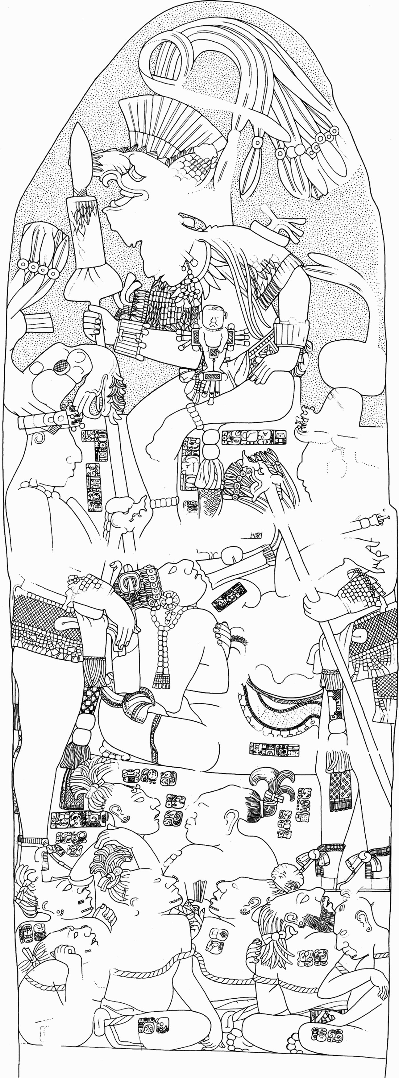
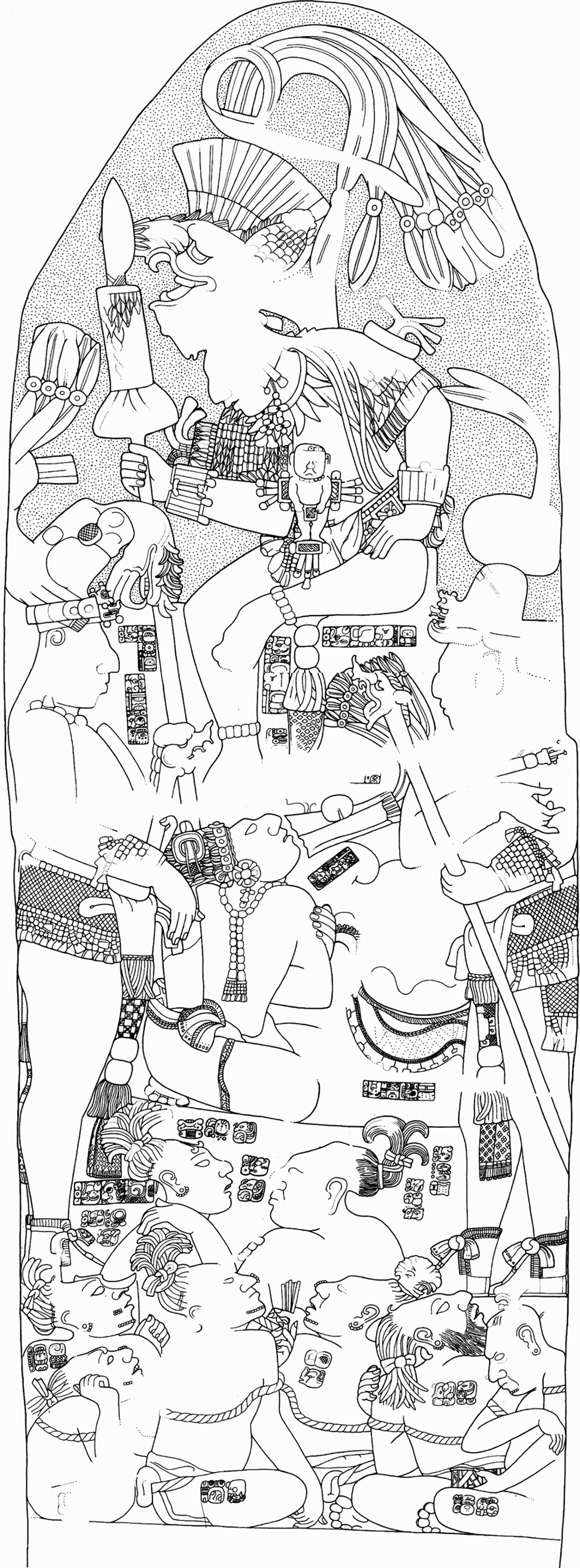
In the polity ruled from Piedras Negras, Guatemala, I believe we have several examples of contested social memory expressed in text and imagery on monuments at outlying secondary centers. Stela 12 from Piedras Negras depicts the last known ruler of that site presiding over his subordinate nobles and captives taken in combat with the neighboring kingdom of Pomona, Mexico (Figure 2). The implication of the text and imagery is that the ruler of Piedras Negras has won a victory in battle over his foes, and the text on the monument phrases this victory as an act of retribution for the defeat of Piedras Negras by Pomona some 250 years earlier (Golden Reference Golden2002:358; Houston and Inomata Reference Houston and Inomata2009:181–182; Houston et al. Reference Houston, Escobedo, Child, Golden, Terry and Webster2000:101; Schele and Grube Reference Schele and Grube1994). The focus of commemoration on this monument is the dynasty of Piedras Negras and its ability to rebound from a previous defeat to vanquish its foes. Text and imagery focus on the might and military capacity of the ruler, and one can imagine that the dedicatory rituals associated with the placement of the stela were designed to reinforce this message. For the kingdom of Piedras Negras, then, the memory that was preserved was one of unity—king and nobles together succeed despite the threat of a long-standing enemy.
Piedras Negras Stela 12. Captives from Pomona, Mexico, are arrayed before Piedras Negras Ruler 7, seated at the top of the monument. The standing figure on the left is the ruler of La Mar. Bearded captive at bottom, second from right, is also depicted on La Mar Stela 3 (drawing by David Stuart, from Corpus of Maya Hieroglyphic Inscriptions 9(1): Piedras Negras, reproduced courtesy of the President and Fellows of Harvard College).
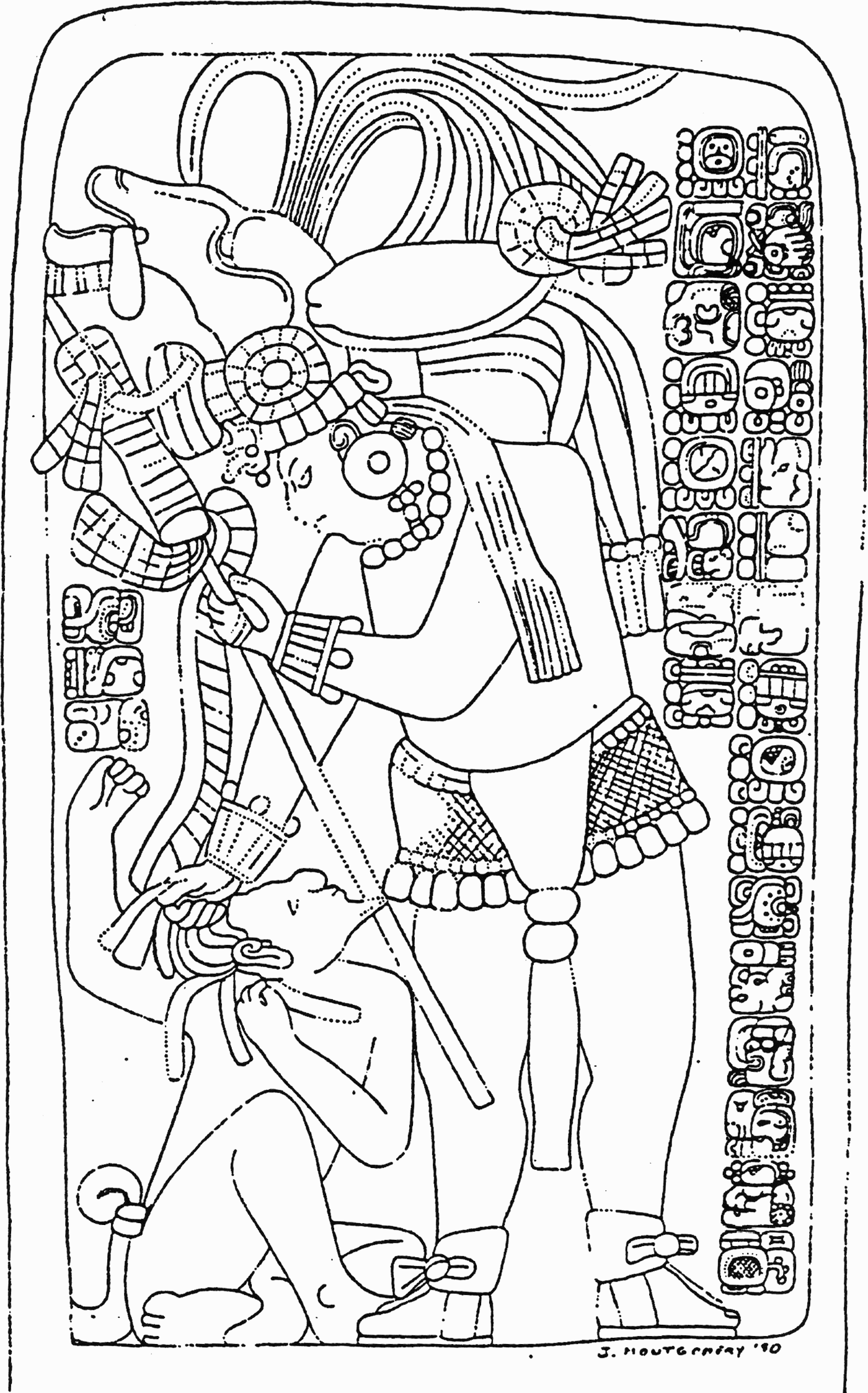
Interestingly, though, one of the victorious nobles on Stela 12 records the capture of two of the same individuals on a stela at his own political center of La Mar, located to the southwest, and ostensibly part of the Piedras Negras polity (Figure 3; Anaya Hernandez Reference Anaya Hernández2001:79; Martin and Grube Reference Martin and Grube2008:153). This claim on the edge of the polity does not directly contradict the victory over Pomona, of course, and the events on the La Mar stela can be smoothly integrated in the history of Piedras Negras dynasty.
La Mar Stela 3, depicting that site's ruler and recording his capture of two of the same individuals depicted on Piedras Negras Stela 12. Both captives are mentioned in the text, while one captive is depicted (drawing by John Montgomery, courtesy of the Foundation for the Advancement of Mesoamerican Studies, Inc., www.famsi.org).
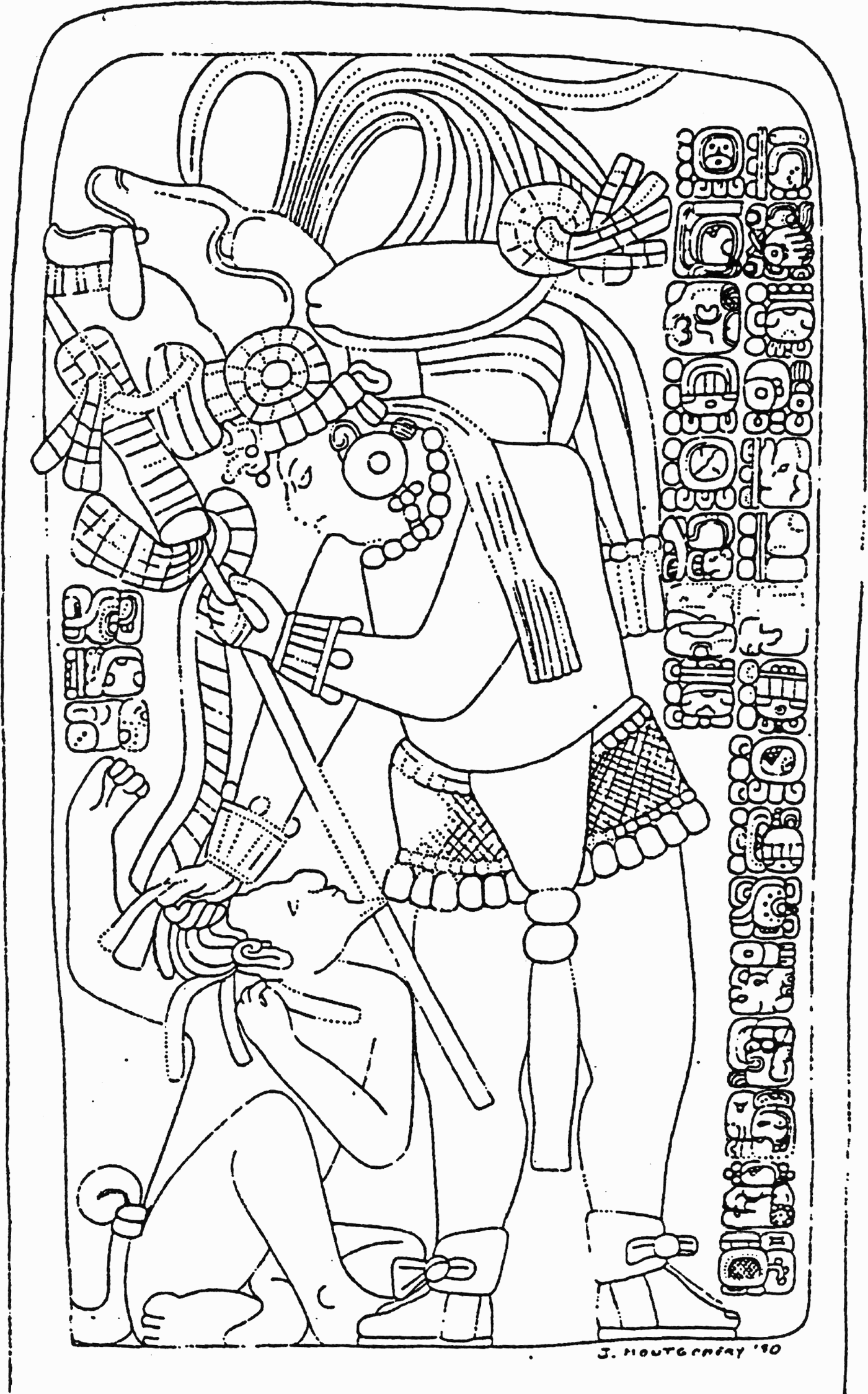
Yet, the La Mar stela also contests the memory of those events. For the community in and around La Mar, who never may have witnessed the battle, its aftermath, or the monument at Piedras Negras, the La Mar stela and its perpetual performance became the touchstone of collective history. The victory and the taking of captives was associated with La Mar and its ruler, not that of Piedras Negras.
Significant here, as mentioned above, is the La Mar stela's dual performative aspect; the perpetual performance of the imagery and the verbal performance of its text (Houston and Stuart Reference Houston and Stuart1998; Stuart Reference Stuart1996). Stelae and altars, unlike some other inscribed monuments (such as lintels), tend to be placed in open, public venues and were intended for an audience that probably included a significant portion of the local populace. The texts on these monuments were presented as poetics by ritually charged actors who may have been the ruler depicted or was perhaps a surrogate competent to present a literate style of history (Gossen Reference Gossen, Bauman and Sherzer1974b:398–399; Hull Reference Hull2003:375–376). Such presentations would not have excluded audience participation but would rather have been affected and, in part, directed by a reactive audience within the constraints imposed by the text and formality of the performance (Hull Reference Hull2003:369).
Furthermore, shared individual memories of the performance would have reinforced social memory of the capture of the Pomona captives by La Mar's ruler, but not that of Piedras Negras, through its emotional impact. The copresence of performer and audience, the shared experience of the ritual, the role of the audience in the performance, and the “very fact that ritual forms a legitimate occasion for emotional display” help commemorative events to form, structure, and maintain collective memory (Rimé and Christophe Reference Rimé, Christophe, Pennebaker, Paez and Rimé1997:117). Moreover, such group activities are recalled better, with greater detail and for a greater duration, than individual recollections of events and experiences. Such group remembrances, however, actually seem to inhibit and direct individual memories along a narrower path than individuals maintain in nongroup settings (Weldon and Bellinger Reference Weldon and Bellinger1997), leading to the convergence required for collective memories to take root (Hirst and Manier Reference Hirst and David2008:193–194).
Thus, to reiterate, the La Mar monument and its associated performance on the edge of the kingdom did not directly contradict the story told by Stela 12 at Piedras Negras. It did, however, allow for reinterpretation of memories associated with the victory over Pomona, and for the community participating as the audience for La Mar Stela 3 it encouraged the association of that victory with the lord of La Mar and not with the paramount king at Piedras Negras. This represents the potential for a historical breach with significant political implications.
There is evidence that the rulers of Classic period polities were cognizant of this potential for their subordinates and the communities surrounding these subordinates to construct alternative histories and to perform conflicting acts of memorialization. Closer to Piedras Negras, toward the kingdom's southern border with its great rival Yaxchilan, is the secondary center of El Cayo, Chiapas. El Cayo was ruled by a series of perhaps five governors who bore the title sajal, a rank of nonroyal nobility. These governors at El Cayo, however, are virtually unique in the time depth of their sajal “dynasty” and in their political ties to multiple superordinate rulers and centers (Chinchilla and Houston Reference Chinchilla, Houston, Laporte, Escobedo and de Brady1993; Houston Reference Houston2003; Houston and Inomata Reference Houston and Inomata2009:175; Mathews Reference Mathews and Trejo1998). Indeed, the governors of El Cayo were tied into royal families through the matriline on at least two occasions. We do not know the origin of one of these women, but the second may have been a member of the powerful Calakmul dynasty. Moreover, although for much of the Late Classic period El Cayo was part of the polity ruled from Piedras Negras, at least some of its sajal acceded through the intervention of a third party, the ruler of Sak Tz'i', an on-again-off-again ally of Piedras Negras (Anaya Hernandez Reference Anaya Hernández2001:77; Houston et al. Reference Houston, Escobedo and Webster2008; Martin and Grube Reference Martin and Grube2008:151).
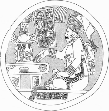
The complexity of El Cayo's political relationships is reflected in the messages conveyed by the monuments. The governors of El Cayo appear alone on their monuments, without their overlords (Figure 4). To those who saw the monuments but could not read the texts, the message is straightforward—the important ritual events memorialized on the monuments were events associated with the rulers of El Cayo and El Cayo alone.
El Cayo Altar 4, depicting the sajal of El Cayo seated before an altar. The text makes no direct reference to Piedras Negras, but the sculptor's signature below the figure indicates that the artist was a Piedras Negras lord (drawing by and used with the permission of Peter Mathews).

Nonetheless, El Cayo Altar 4 implicitly acknowledges the dominance of the ruler of Piedras Negras with regard to the creation of social memory at El Cayo. The sculptors of this and other monuments from El Cayo were nobles from Piedras Negras, presumably sent by the ruler of the primate site (Chinchilla and Houston Reference Houston1993:58; Houston et al. Reference Houston, Escobedo and Webster2008; Martin and Grube Reference Martin and Grube2008:153), and authorized to produce a restricted history that did not impinge upon the narratives developed at the polity level.
The texts, acting as a “guarantor of authenticity” (Hull Reference Hull2003: 336) lead performer and audience along a prescribed path that allowed for innovation but not dramatic deviation, and monuments from El Cayo, unlike La Mar Stela 3, do not recapitulate historical events otherwise recorded at Piedras Negras.
Thus, the text, imagery, and associated performance of Altar 4 (and other monuments from El Cayo) offered a restricted history that did not impinge upon the narratives developed at the polity level. Participants in the performance of narratives associated with the El Cayo altar would have had all the same potential for reinvention and innovation of social memory as the performers of La Mar Stela 3. But transformations of the collective history associated with the El Cayo altar did not directly transform any narratives from Piedras Negras known to modern scholars.
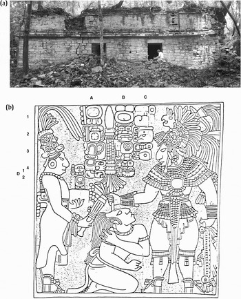
Moving south from El Cayo, I want to turn to the border of the Yaxchilan kingdom. By the eighth century a.d. the rulers of Yaxchilan had begun to establish a well protected, fortified border with Piedras Negras (Golden Reference Golden, Brown and Stanton2003; Golden and Scherer Reference Golden and Scherer2006; Golden et al. Reference Golden, Scherer and Muñoz2005, Reference Golden, Scherer, Muñoz and Vasquez2008; Scherer and Golden Reference Scherer and Golden2009). Sites such as La Pasadita and Tecolote were the seats of sajal appointed by the k'uhul ajaw of Yaxchilan to control that boundary in the name of the central authority (Figure 5). Unlike the governors of El Cayo, we have no evidence of multigenerational sajal dynasties for the Yaxchilan polity, and our current evidence suggests that the rulers of Yaxchilan exercised a more direct and fundamental control over the role and status of their subordinates than did the rulers of Piedras Negras.
Standing building at Tecolote, Guatemala (above; photo by Arlen Higgenbotham). Below is La Pasadita Lintel 2 (Corpus of Maya Hieroglyphic Inscriptions, drawing by Ian Graham, reproduced courtesy of the President and Fellows of Harvard College). From left to right: Tiloom, sajal of La Pasadita; captive from Piedras Negras (kneeling); Bird Jaguar IV, ruler of Yaxchilan.

As part and parcel of this control, the sajal in the Yaxchilan kingdom (most known from looted monuments) were typically depicted in performance with the ruler of Yaxchilan, and at El Cayo some of these monuments were carved by the same sculptors who produced monuments at the capital. Further, these monuments are uniformly lintels, not stelae or altars. As lintels, they would have been set into narrow doorways of palatial structures set back off of public plazas where their audiences were presumably limited to a much smaller subset of the population than those with access the lintels and altars set into the broad patios of Yaxchilan itself.
Here, then, we have control over collective memory and history on multiple levels. First, access to these monuments is restricted to a limited audience—the collective for whom these monuments served as a mnemonic for memory was presumably smaller than that of the monuments described above from La Mar and El Cayo. Second, the presence of the ruler meant that for any given performance associated with the monument, the ruler was always present (Houston and Stuart Reference Houston and Stuart1998; Stuart Reference Stuart1996), always watching and sanctioning the transformations of memory involved with such performances. Third, almost none of the events recorded on these monuments from secondary centers were recorded at Yaxchilan itself, and thus, as with El Cayo Altar 4, the potential for rewriting memory of events associated with the polity center did not exist. In the one known case where the same event is recorded at La Pasadita and Yaxchilan, the subject is the capture of a Piedras Negras prince, recorded on La Pasadita Lintel 2 and Yaxchilan Hieroglyphic Staircase 1 (Alexander Safronov cited in Martin and Grube Reference Martin and Grube2008:149; Nahm Reference Nahm1997:68). The presence of the ruler of Yaxchilan on Lintel 2, however, limits the possibilities for the sajal of La Pasadita to contest or diverge from the royal narrative in making collective history as the rulers of La Mar had done.
Archaeological investigations in the Yaxchilan kingdom also allow us to speak of architecture's role in the construction of memory in a way that we cannot yet do at La Mar and El Cayo, where less research has been carried out. Recent fieldwork at the neighboring border sites of Tecolote and La Pasadita reveal a startling similarity in the style of monumental architecture, all of which was built in a relatively short span during the eighth century a.d. (Golden et al. Reference Golden, Scherer and Muñoz2005, Reference Golden, Scherer, Muñoz and Vasquez2008; Scherer and Golden Reference Scherer and Golden2009). On both sites, archaeologists found standing, vaulted buildings with polychrome murals (though the building at La Pasadita has collapsed since its initial documentation by Ian Graham [Golden et al. Reference Golden, Barrientos, Hruby, Muñoz, Laporte and Escobedo1999]). These buildings are virtually identical in size, the number and placement of entrances, and in the style of the masonry employed. In fact, but for the late addition of a wall in one room and the installation of carved lintels above the doors at La Pasadita, these structures appear to be mirror views of one another. Moreover, a primary axis for site planning at Tecolote and La Pasadita is 120 degrees, as it is at Yaxchilan.
Inside, too, the palace buildings that constitute the architectural foci of Tecolote and La Pasadita give the impression of centralized artistic vision. At Tecolote, the style of calligraphic script in an extensive mural text hints that some of the painters who worked on the famous murals of Bonampak (themselves probably sent from Yaxchilan) also worked at Tecolote (Stephen Houston and David Stuart, personal communication 2004). At La Pasadita, the near identity in style and color palettes of murals at La Pasadita and Yaxchilan further highlights the epigraphically documented ties between these two sites (Golden et al. Reference Golden, Scherer, Muñoz and Vasquez2008:63; Kamal et al. Reference Kamal, Ware, Houston, Chabries, Christiansen, Brady and Graham1999:1393).
Although much remains to be done to fully document the architectural programs of both sites, the initial impression is one of an architectural template; it may even be that a team of “architects” or masons was dispatched from the capital to these border sites (Golden et al. Reference Golden, Scherer, Muñoz and Vasquez2008:267). Given the importance of architectural layouts in the performance of rituals, the suggestion is that the sajal and their entourages at border sites such as Tecolote and La Pasadita were constrained to perform rituals associated with monuments and the formation of collective memory within spaces dictated from the center. In so doing, a modicum of control was maintained by Yaxchilan's rulers over the events memorialized at the frontiers of authority in the kingdom.
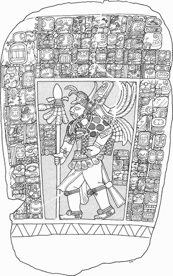
Finally, in a last example from an adjacent polity a different sort of fraying of collective memory and history can be seen on a small stela, now in a private collection, on which a sajal is depicted in profile (Figure 6). We do not know the site from which this monument was looted, but the text indicates that this sajal acceded to his office under the auspices of the ruler of Sak Tz'i'. With a dedication date of a.d. 864, however, it is the last known mention of Sak Tz'i'; we have no contemporary monuments from Sak Tz'i' itself (Anaya Hernández Reference Anaya Hernández2001:81; Martin and Grube Reference Martin and Grube2008:146; Mayer Reference Mayer1980:50–51; Miller and Martin Reference Miller and Martin2004:190–191). This could be a sampling error, but it may also be that the Sak Tz'i' kingdom had essentially ceased to function as an effective political entity at this time, as had virtually all of the regional powers except Tonina. Moreover, the style of the imagery is remarkably innovative or “foreign,” and in some ways more closely resembles the monuments of the distant and newly resurgent Seibal than those of earlier Usumacinta region monuments.
Stela depicting a sajal from an as yet unidentified site (drawing by and used with the permission of Simon Martin).

Interestingly, the imagery and the performance of the text provides for the audience a grounding of legitimacy based in long-remembered and replicated patterns of accession to office under the auspices of a superordinate ruler who may no longer have existed. The imagery, in contrast, was a break with the past; its conscious newness was framed by traditional monumental content and performance (a stela with image and text) that made the message of authority rational and acceptable. It may, in fact, be that this petty ruler sought to maintain the memory of a defunct superior authority in order to legitimate his own power, while at the same time establishing new patterns of legitimacy that did not rely on older forms.
Such patterns of manipulating social memory on the part of subordinate nobles have been noted on the peripheries of other societies as well. The Nayaka states of India, for instance, were led by military leaders who grounded their legitimacy by acknowledging the authority of Vijayanagara, while at the same time they resisted that authority (Sinopoli Reference Sinopoli, Van Dyke and Alcock2003:17–33). Compared to Vijayanagara, Nayaka kingdoms were fragile and small, but “their rhetoric was vast, entailing, in many cases, claims to the mantle of Vijayanagara's legitimacy” (Sinopoli Reference Sinopoli, Van Dyke and Alcock2003:29). Such rhetoric also clearly plays a part in the creation of medieval titles such as Holy Roman Emperor, which laid claim, with varying levels of success, to restructured and re-created memories of Rome and its continental authority. The same may also characterize many of the large, stable Maya polities during the Late Classic period, whose rulers memorialized in text and sculpture their connections with the dying or dead polity of Teotihuacan (see Golden [Reference Golden2002:381–416] for an overview of such Teotihuacan-related activities at Tikal, Copan, and Piedras Negras).
CONCLUSIONS
Thanks to the advances that epigraphers and archaeologists have made in recent decades, the study of the Classic Maya has reached the point at which we have access to a more complex and complete view of political history and the art of manipulating social memory as a political tool. Even as we try to piece together a coherent history for any given polity, we must remain aware that social memory at the polity level is a complex negotiation of multiple segments of social memory at secondary centers and other political communities scattered across the landscape of the kingdom. We cannot fully understand the processes of memorialization at primate centers unless we can better piece together the various segments that such processes were acting upon and reacting to.
Furthermore, because processes of memorialization operated at all levels of society, whether in the daily rituals of a rural household or in the dedication of a new stela and the performance of its narrative text, we can begin to develop a better picture of the social linkages of memory connecting ruler and subject throughout the kingdom that, in the absence of modern mass media, helped to create the imagined community that was the Classic Maya polity. As polities grew larger, however, and the political hierarchy more complex, over the course of the Classic period it would have become more difficult for rulers to rely on a coherent collective memory to unite the community and bolster their authority. We should examine monuments closely not just for the pieces of a coherent history, but also for the attempts to restructure that history to challenge royal authority and for the efforts of kings to maintain their control over the fraying edges of their kingdoms.
RESUMEN
Este artículo explora los procesos de la historia y la memoria social referentes especialmente a los centros políticos secundarios ubicados en los límites de los reinos mayas de Piedras Negras y Yaxchilan durante el período clásico. Durante el transcurso del clásico tardío (600–900 d.C.) los gobernantes de las entidades políticas en la cuenca del río Usumacinta delegaron cada vez más a los señores subordinados que gobernaban estos centros secundarios para patrullar y controlar los límites de sus territorios. Para los gobernantes de cualquier estado, formular una historia coherente que dirija la memoria social es un acto político que es crítico para mantener la unidad de la comunidad política. Sin embargo, con el avance del período clásico, los reyes permitieron a sus clientes una prerrogativa anteriormente exclusiva a la realeza; fueron otorgados sus propios monumentos inscritos. Los monumentos, juntos con los actos rituales asociados, formaron una parte integral de la construcción de la historia y de la memoria colectiva en las comunidades locales, e hizo posible que los nobles secundarios tuvieron el poder de reestructurar la memoria social colectiva para sus propios intereses. Esto aumentó el potencial para impugnar la historia y la autoridad real a través del reino. Este trabajo trata principalmente los monumentos de los sitios La Mar y El Cayo (los cuales formaron parte del reino de Piedras Negras) y La Pasadita y Tecolote (del reino de Yaxchilan). Incluye también un ejemplo de un monumento saqueado de un sitio desconocido que perteneció aparentemente al reino de Sak T'zi', una entidad política vecina a Piedras Negras y Yaxchilan. Cada uno de estos ejemplos muestra un proceso diferente que ofreció a los nobles subordinados el poder de disputar la memoria social y la historia sancionadas por los reyes. Además, muestran las maneras en que los reyes actuaban para mantener las riendas de la historia y de la memoria.
ACKNOWLEDGMENTS
I wish to thank Sharon Aponte Misdea, with whom I originally organized the AAA session that led to this set of articles on Maya social memory; Greg Borgstede for all of his efforts in seeing that these articles were published; and the other scholars in this special section for their patience and persistence. I also wish to thank the Instituto de Antropología e Historia de Guatemala and the Consejo Nacional de Áreas Protegidas for permission to conduct research in the Sierra del Lacandon National Park, and the the Fundación Defensores de la Naturaleza for their ongoing support and assistance. My thanks also to Simon Martin and Peter Mathews for permission to publish their wonderful drawings. Finally, I am grateful to Tomas Barrientos, David Freidel, Andrew Scherer, Carolyn Tate, and Javier Urcid for their insightful comments and edits on earlier drafts of this paper. All errors of fact and interpretation are, of course, my own.