

INTRODUCTION
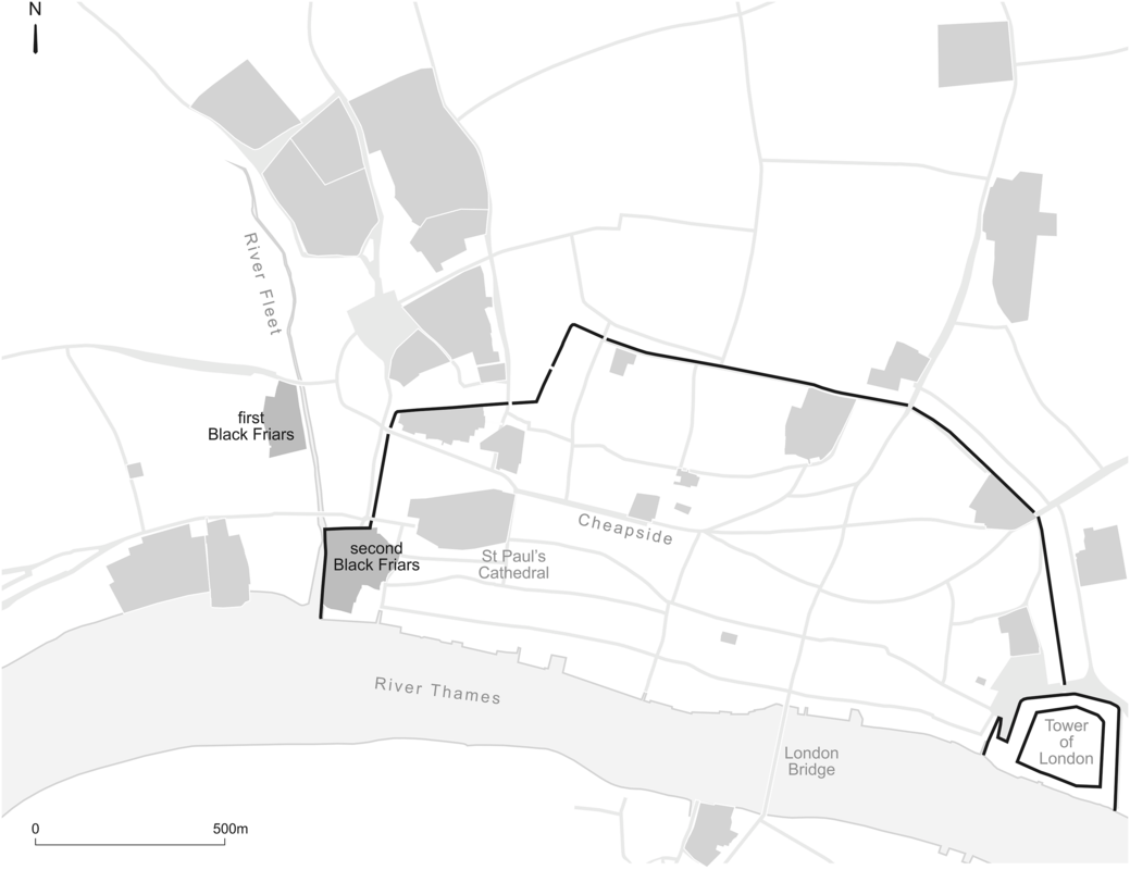
In the first two decades of the thirteenth century two remarkable men, Francis of Assisi and Dominic of Caleruega, created new religious movements within the medieval Church: the ‘brothers’ or friars. Dominic’s order of preacher-monks, the Dominican or Black friars, arrived in England in 1221 and, having established the first friary in Oxford, then founded the London priory in Holborn, a short distance west of the walled city on the road leading into Newgate (fig 1; ‘first Black Friars’ on fig 2). Over the next fifty years Prior Gilbert de Fresnay and his successors built a church and accommodation wings. But c 1274 the London Dominicans decided on a move to a newer and larger site within the walled city itself (‘second Black Friars’ on fig 2). In the last quarter of the thirteenth century the friars forged a partnership with Archbishop of Canterbury Robert Kilwardby and Mayor Henry le Waleys and, with the support of Edward i, embarked on a huge construction project. They moved the city wall westwards to the banks of the river Fleet, reclaimed land from the river Thames and started building a new church and cloister.Footnote 1 The scale of the works and the calibre of the friars’ supporters ensured that the new friary church was to be a great architectural – and spiritual – mark on the London landscape. One important part of this new cloister and precinct was the friars’ grand chapter house, the subject of this paper.
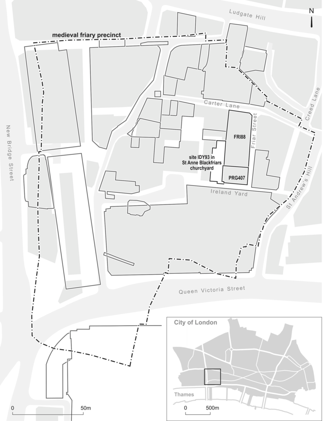
Map showing the location of the archaeological sites discussed (outlines of other archaeological sites within the friary precinct are indicated but not labelled; scale 1:1750). Image: the authors.

Map showing the location of the first Black Friars in Holborn and the second Black Friars within the city wall (other religious precincts are indicated in grey tone but not labelled; scale 1:17,500). Image: the authors.

CONSTRUCTING THE NEW BLACK FRIARS IN THE LATE THIRTEENTH CENTURY
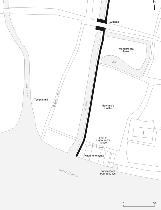
By the 1270s the south-west part of the city of London – soon to be the second Black Friars – was a mix of large and small properties abutting the Roman city wall and the river Thames (fig 3). The land sloped down southwards towards the Thames, and westwards to the river Fleet, a tributary of the Thames on the other side of the city wall.
Map of the landscape of the future Black Friars in the 1270s (scale 1:2000). Image: the authors.

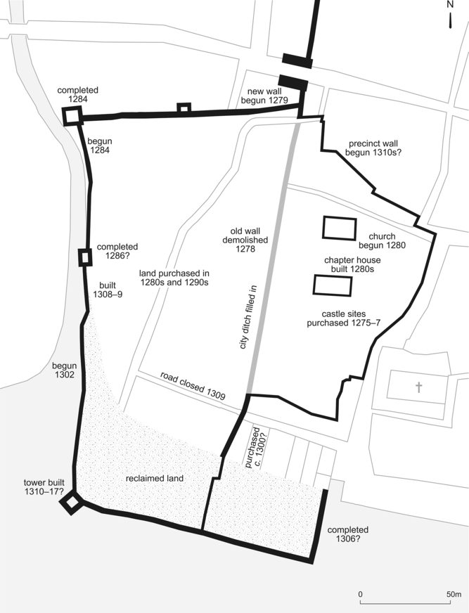
Between 1275 and 1277 the friars acquired two dilapidated Norman castles occupying the corner of the city: Baynard’s Castle and part of Montfitchet’s Tower. The civic authorities granted them permission to close off the lane between the castles.Footnote 2 In 1278 the king granted permission to begin demolition of the part of the city wall that lay to the south of the city gate of Ludgate.Footnote 3 These property acquisitions and permissions enabled Prior John of Darlington to begin work on the new friary. Construction work on the church may have begun as early as 1278, when the king granted additional alms to the friars, but the earliest record of construction works at the friary is in June 1280.Footnote 4 In 1279 the king and mayor began work on the extension to the new city wall (fig 4). The new stretch of wall – about 565 yards (515m) long – functioned both as city defence and friary boundary; the construction process also allowed some 1¾ acres of land to be reclaimed from the Thames (6,800m2), eventually making a friary precinct of just over 8 acres (3.25ha).
Map showing the construction of the new city wall and the Black Friars priory beginning in 1278–9 (scale 1:2000). Image: the authors.

ARCHITECTURAL AND ARCHAEOLOGICAL EVIDENCE FOR A LATE THIRTEENTH-CENTURY VAULTED BUILDING
As a result of the Dissolution of the Monasteries (1536−41) and the Great Fire of London (1666), very little of the fabric of the Dominican friary survives above ground − a common lament for a largely lost medieval London. The site of the London Black Friars has, however, been the subject of a great deal of historical and archaeological research; archaeological sites discussed here are shown on fig 1.Footnote 5
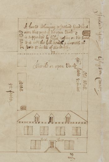
The building that concerns us was within the zone of destruction of the Great Fire of 1666, although the lower storey survived in part. It is first mentioned in an early eighteenth-century survey of the estate of the rectory of St Anne Blackfriars.Footnote 6 An old ruined building is shown running east–west on the north side of Ireland Yard and had a vault, a column and thick stone walls (fig 5). Annotations describe the substantial north and south walls as ‘old wall’ and the ruined west end as ‘the old or open Vault’. The east end was still built over: ‘a house belonging to Ireland Yard hangs over this part of the open Vault & is supported by Pillar resting on the Same’ (the central column towards the east of the building appears to be illustrated on the plan). The total length of the building, including the open and built-on portions, was given as 57ft 4in (17.5m). Doors (or window rere-arches?) were indicated at the west end of the north wall and in the opposing corner at the east end of the south wall.
Detail from a survey of the estate of St Anne Blackfriars of 1702; this appears to be the first illustration of the building here identified as the chapter house; north is to the left (LMA, COLLAGE 1650). Image: courtesy of London Metropolitan Archive.

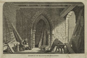
This unusual survival from medieval London came to the attention of a few London historians during the mid-nineteenth century. Various engravings and watercolours – all apparently based on a common original – illustrate a Dickensian scene of a coffin-maker’s workshop in a medieval crypt (perhaps the built-over eastern end of the vaulted building illustrated on the 1702 survey; see fig 5). In an engraved version of c 1830 with the title ‘Archway of Blackfriars monastery’, newly delivered planks lean against what appears to be an arched medieval doorway, a completed coffin sits on a trestle and the coffin-maker sits on a basket, while nonchalantly looking at the viewer (fig 6).Footnote 7 A slightly later watercolour version of the same scene is entitled ‘Crypt of St Anne Blackfriars’.Footnote 8
Engraving of c 1830 showing a coffin-maker’s workshop in a medieval crypt or undercroft in Blackfriars; the evidence of fig 7 suggests that the printer mistakenly reversed the perspective (LMA, COLLAGE 7063). Image: courtesy of London Metropolitan Archive.

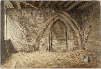
The London archaeologist and historian Philip Norman FSA visited the site at the end of the nineteenth century and painted a watercolour of the crypt or cellar, apparently empty and unused.Footnote 9 The perspective is similar to the engraving of c 1830 (see fig 6), but Norman’s painting reveals that the arched doorway is in fact a blocked window opening set within a large rere-arch (fig 7).
Watercolour of the late nineteenth century by Philip Norman FSA, ‘Arch of conventual buildings’, showing a blocked window set within a large rere-arch (Museum of London, C624). Image: courtesy of Museum of London.

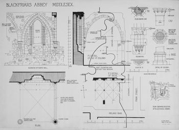
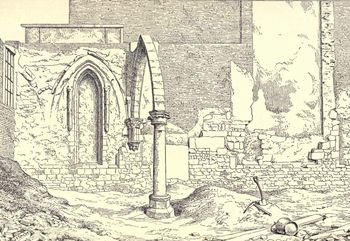
A few years later, in 1900, the building that had housed the coffin-maker, 7 Ireland Yard, and the adjacent building were pulled down to be redeveloped as offices (see fig 1; PRG407). In a remarkable ‘rescue excavation’ – more architectural than archaeological – William Webb and George Thow Smith (architect and assistant at the London County Council) recorded the medieval remains in the cellar of the building as they were being exposed and demolished. They recorded two medieval windows on the north wall, a column – once part of an arcade – and a surviving transverse rib (fig 8).Footnote 10 Philip Norman soon published this remarkable site, making use of Webb and Smith’s drawings and a detailed sketch by the topographic artist and folklorist John Emslie (reproduced as fig 9) and a site photograph. Although he had earlier visited the site, Norman’s account implies that he himself did not see the remains being exposed and dismantled in May 1900.Footnote 11 Norman dated the remains to the late thirteenth century and interpreted them as an undercroft or crypt of Black Friars. He also drew attention to the location of the remains: close to the position of the old yard called Cloister Court (see annotation on fig 5); he did not, however, speculate to which part of the cloister the undercroft might belong.
Plans and elevations of 1900 by George Thow Smith recording the medieval remains at 7 Ireland Yard (V&A, D.1291–1907). Image: courtesy of the Victoria and Albert Museum, Department of Prints, Drawings and Paintings.

Drawing by John Philipps Emslie showing the medieval remains exposed and demolished at 7 Ireland Yard in May 1900. Image: courtesy of London Topographical Society.

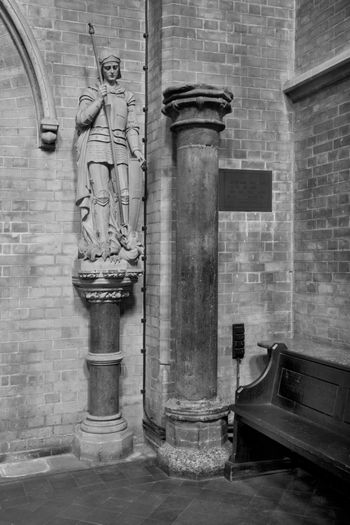
The architectural recording and subsequent demolition of 1900 was not, however, the end for these remarkable remains of medieval architecture. The column was moved to the new Dominican friary in Belsize Park, London. The friary had been re-founded in 1868 and one of the first friars, Raymund Palmer, was a historian with a research interest in the medieval English order. Over four decades he researched and wrote articles on all fifty-three English Dominican houses, including the London friary.Footnote 12 It is likely that Palmer, in conjunction with Norman and/or Webb, arranged for the column to be moved to the new friary. At a friary council meeting on 16 October 1900, at which Palmer was present, it was agreed that ‘the column from the ruins of the ancient Blackfriars is to be erected in the Porch by the Lady Chapel [of the nineteenth-century friary church]’. The implication is that the column had already been moved to the friary, but not yet re-erected.Footnote 13 The column is now in the north-east corner of the nave of the friary church (fig 10).
View of the late thirteenth-century column from the 7 Ireland Yard building, re-erected in 1900 in the new Dominican friary church in Belsize Park, London. Photograph: Andy Chopping/MOLA.

In 1900 the preserved arch from the Ireland Yard cellar was moved to a new home in Surrey. The local Croydon Advertiser and the rather more distant Cambridge Daily News both reported the move, and revealed the identity of the benefactor.
The desirability of preserving so interesting a portion of Old London was recognised by the authorities, and the offer of Mr. Wickham Noakes, a past Master of the Merchant Taylors’ Company, to erect the archway in his grounds at Selsdon Park was accepted. This has now been carried out.Footnote 14
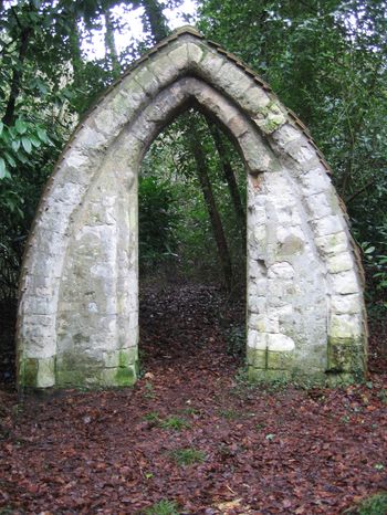
Noakes was a wealthy brewer who had recently purchased the large house and grounds of Selsdon Park, and he was busy setting up his new country estate; his antiquarian tastes had perhaps been aroused by his association with the Merchant Taylors.Footnote 15 A metal plaque by the arch recorded its re-erection in June 1900.Footnote 16 The arch survives (without the plaque) in the grounds of the house, now the Selsdon Park Hotel, in a wooded thicket of the garden (fig 11).Footnote 17
Internal window rere-arch from the 7 Ireland Yard building, re-erected in 1900 in the grounds of Selsdon Park, Croydon. Photograph: the authors.

In 1912 Philip Norman’s colleague, Alfred Clapham FSA, published a major study of the friary in Archaeologia. In this remarkable piece of work he drew on documentary and archaeological evidence and reconstructed the layout of the late medieval Dominican precinct; the article has been the point of departure for all subsequent work on the friary. Clapham also reviewed the evidence for the Ireland Yard building, reproducing Smith’s plan and elevation drawing of 1900 (Clapham’s fig 1, reproduced here as fig 8), and he noted the relocated fragments of the building in Croydon and Belsize Park. Clapham identified the Ireland Yard undercroft as part of the ‘south dorter’ (dormitory), with a chamber above belonging to the Dominican provincial prior, the head of the English Order.Footnote 18
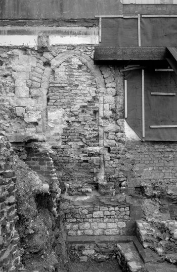
In 1988 another part of the building was discovered. Archaeologists from the Museum of London’s Department of Urban Archaeology were carrying out a rescue excavation at 10 Friar Street (see fig 1: site FRI88) and towards the end of the project they discovered that the party wall to the building to the south incorporated a window arch that had been bricked up, as well as remnants of four buttresses (fig 12). The 1988 external window (exposed and viewed from the north) corresponds to the 1900 internal rere-arch (viewed from the south). The window was recorded and subsequently preserved in the new office block (with the buttresses removed after recording).Footnote 19
View of the external window arch, discovered in the 10 Friar Street excavation in 1988. Photograph: courtesy of MOLA.

In 1993 one of the authors supervised a small-scale archaeological excavation and watching brief in St Anne Blackfriars churchyard, just north-west of the Ireland Yard undercroft (see fig 1: site IDY93). The site recorded a little more of the north wall of the undercroft: the removal of some churchyard paving revealed further material identified as the wall core to the west of the preserved (1988) window, but no wall facing could be traced.Footnote 20 A short stub of medieval ragstone masonry survives above ground in the churchyard and this can now be identified as part of the south-west corner of the chapter house.
In 2011 the present authors carried out some further archaeological and architectural recording of the remains of this building. They re-surveyed the wall stub in St Anne Blackfriars churchyard, and visited and recorded in detail the relocated remains of the 1900 excavations – the column in St Dominic’s Priory, Belsize Park, and the rere-arch in Selsdon Park, Croydon.
DISCUSSION OF THE ARCHAEOLOGICAL EVIDENCE OF THE VAULTED CHAMBER
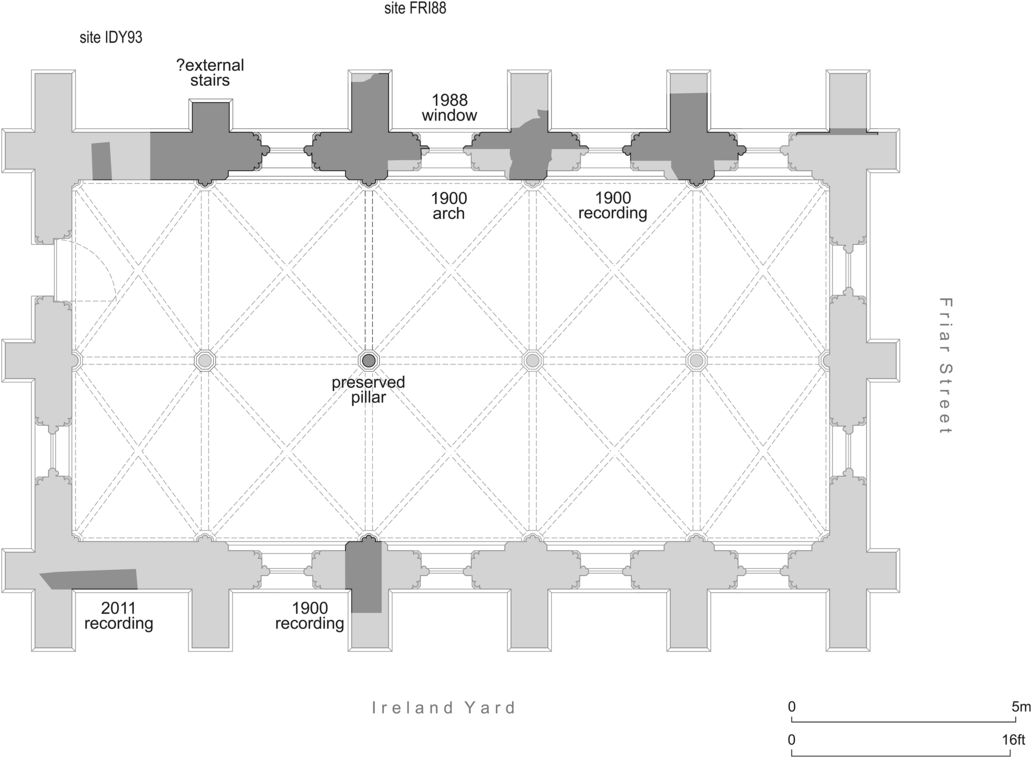
The architectural and archaeological elements that have been recorded in the various sites are illustrated in fig 13. These elements form part of an undercroft or vaulted chamber of a substantial medieval friary building. The position of east and west walls can be inferred from documentary and topographic clues. Although Smith’s plan of 1900 is at a very small scale, his excellent inked elevation (see fig 8) shows three bays and parts of two more can be seen. The length of the building was given as 57ft 4in (17.5m) in the 1702 survey (see fig 5); analysis of the various archaeological observations shown in fig 13 would suggest that the full external length (buttress to buttress) was in fact 20.1m (65ft 9in), with the internal length 16.9m (55ft 6in). Smith’s drawing shows the lower parts of three chamfered rere-arches to the east of the window; he also usefully supplied written measurements. The re-recording of the Croydon rere-arch (moved in 1900; recorded in 2011) demonstrates the accuracy of Webb and Smith’s original survey. A photograph of 1900 and Norman’s watercolour (see fig 7) both convey the severe deterioration of the Reigate stone dressings above the springing line of the ribs. The column was better preserved, having been cut from a harder stone, Purbeck marble (a polished limestone). It is clear that Webb or Smith ‘clarified’ and to some extent ‘restored’ what they saw through an architect’s eye − normal practice at the time. The south wall, with its single vault respond, was traced by them, allowing the internal north–south width to be accurately measured (8.08m; 26ft 6in). Webb and Smith recorded the inner face of the north wall in 1900 and the Museum of London archaeologists recorded the outer face in 1988; no opportunity has yet arisen for a direct measurement of the wall thickness, but it was c 1m or 3ft 6in. The full external width of the building (buttress to buttress) is thus about 13.0m (42ft 7in).
Plan showing the fabric of the vaulted chamber recorded in 1900, 1988, 1993 and 2011, and the relocated fabric now at the Dominican friary (Belsize Park) and Selsdon Park (Croydon), also recorded in 2011 (scale 1:150). Image: the authors.

The present authors located the Croydon rere-arch in the garden of Selsdon Park Hotel (following Clapham’s ‘tip off’ in his Archaeologia paper).Footnote 21 The arch lies virtually forgotten in a thicket, cased and capped in brick and tile. It seems that the move was achieved by removing the entire upper part of the rere-arch in one or two pieces, leaving the fine lime joints undisturbed (see fig 11). No attempt had been made to remove the surrounding wall rib (probably too deteriorated to rescue). The dressed work has since suffered a century of exposure to the weather, and crude repairs with cement have done little to help. For all this, re-recording the preserved arch allowed some useful ‘fine-tuning’ of the reconstruction.
The Purbeck marble column, nearly intact, must have presented fewer problems to its rescuers than the rere-arch. The opportunity was taken to re-record it in 2011 at St Dominic’s priory, revealing insignificant errors in the earlier recording, if just enough to justify the exercise.
The 1988 excavation (site FRI88) revealed the external side of the window of which the removed rere-arch formed part, alongside remains of four buttresses. The lower parts of the wall face incorporated remains of a ground table course and below this, a well-preserved chamfered plinth. This was of great importance in showing the external ground level that the builders achieved only by dumping much material around the foundations (see below). This must have been part of a major campaign of ground works to create a fairly uniform floor level in the church and chapter house, with the space in between to be linked by a cloister walk (built after the choir and chapter house). About 9.5m (length) of superstructure survived to a maximum height of 4.6m; the foundations were traced for a total distance of 15.8m during the watching brief at the end of the excavation. The buttresses rested on much larger stepped foundations, perhaps witness to the topographical difficulties tackled by the builders (who were working on the slope leading down to the Thames). Preservation was best towards the west end, but the dressed limestone of the window was greatly deteriorated. Photographs (for example, fig 12) and an elevation drawing, together with accompanying context descriptions and plans made to the high standards of the Museum of London’s Department of Urban Archaeology allow detailed study of this wall.Footnote 22 The 1900 records can therefore be fitted with precision into the present-day topography of the city.
The undercroft was clearly more than a grace note to the lost chamber over. All the indications are of a building on a monumental scale: the massive buttresses hint at a lofty hall-like superstructure over a highly ornate and well-lit vaulted chamber; by no stretch of the imagination a lowly undercroft. With plastered, painted finishes and stained glass, it could have appeared very colourful and in the first rank of its contemporaries − a theme developed below (see Conclusions).
IDENTIFYING THE BUILDING
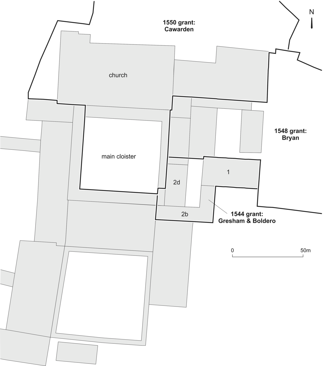
The layout of the church and two cloisters of the friary has recently been reconstructed in some detail.Footnote 23 The authors’ vaulted chamber lies to the east of the main cloister and to the south of the church choir. The identity of this building in the early sixteenth century, shortly before the closure of the friary, can be investigated: this is thanks to the survival of a very useful series of post-Dissolution grants and their accompanying ‘particulars for grant’, prepared in the 1540s by surveyors from the Court of Augmentations (the government ‘department’ administering the Dissolution of the Monasteries). The various medieval chambers and buildings on the east side of the main cloister were divided between three grantees in 1544, 1548 and 1550. The southern part of the east wing of the cloister together with some buildings and chambers to the east (almost certainly including the vaulted chamber) were granted to the East Anglian gentlemen Paul Gresham and Francis Boldero in 1544 (fig 14). Moving north, the northern chambers of the east cloister and another building further east were granted to the courtier Francis Bryan in 1548; the eastern cloister walk and most of the church were granted to the King’s Master of the Revels, Thomas Cawarden, in 1550.Footnote 24
Plan showing parts of the church and main cloister of Black Friars, and the post-Dissolution grantees (scale 1:1750; numbers 1, 2b, 2d refer to buildings described in table 1). Image: the authors.

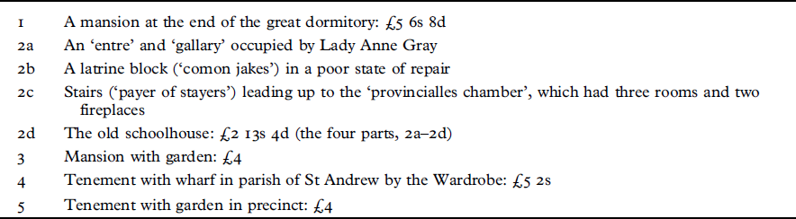
The grant and accompanying ‘particulars for grant’ to Gresham and Boldero contain much topographic detail for this part of the friary.Footnote 25 The sale included five separate buildings and tenements, most of which were in and around the east side of the main cloister; one of these was further subdivided into four elements. These are described and valued, using the annual rental value, as shown in table 1.
The buildings and rooms on the east side of the main cloister sold to Paul Gresham and Francis Boldero in 1544 (based on Crown grant and ‘particulars for grant’, with modern numbering).

The total rental value of the properties was thus calculated at £21 2s. Using ‘multipliers’ of 10× and 8× to convert the rental value into a freehold value (the different multipliers applied to different parts of the property), a sale price of £174 2s 8d was calculated and agreed with Gresham and Boldero. The parts of the property numbered 3–5 in table 1 clearly lie elsewhere in the precinct (for example, the wharf property must lie on the Thames waterfront to the south-east of the precinct, owned by the friary).
Clapham identified the undercroft building as part of the ‘provincialles chamber’, the London residence of the prior of the Dominican province of England (2c in table 1). It is possible that the upper chamber of the building was at one stage so employed. Clapham focused, however, on the part of the property with the most descriptive detail (numbered 2a–2d in table 1), ignoring the other four elements. The Court of Augmentations surveyor had to write more descriptive detail here, probably because these chambers were located in and immediately adjacent to the east cloister: a complicated arrangement of cloister walk, stairs, and ground- and upper-floor rooms were all shoehorned into this area. The present authors suggest that the building with the undercroft is in fact the ‘mansion at the end of the great dormitory’ (1 in table 1; mansio… ad finem magni dormitorii). This mansion and its adjacent garden were worth an annual rent of £5 6s 8d in 1544, one of the highest rents in the former friary: this high rental value implies a substantial and separate building, worth rather more than the various apartments carved out of the east claustral wing itself. By the mid-1550s the mansion was described as a ‘greate stone howse being a storehowse’.Footnote 26
The architectural evidence discussed below suggests that the building dates to the late thirteenth century: it is, therefore, one of the first buildings to be built in the second Black Friars. It seems unlikely that a vaulted two-storey building would have been constructed at this time as a residential mansion, even for the provincial prior or London prior; there would surely have been other priorities, not least of which would have been the cloister or the church nave. The priors’ houses at the London White Friars and Crossed Friars were rather later, dating to the late fourteenth or early fifteenth century. A two-storey buttressed building with a vaulted chamber, built in the first decades of the (re-founded) friary could well have incorporated the original chapter house. Although the position of this postulated chapter house would have seemed unusual in the 1280s – standing on its own to the south of the new church – work soon began on the friary cloister (see fig 4). Once the cloister was completed c 1310, the chapter house building occupied a more conventional position, forming a wing at right angles to the east claustral range.Footnote 27 This was no doubt planned from the outset. The chapter house apparently formed a higher priority than the cloister walk.
There is fortunate documentary evidence for the construction of a chapter house at this time. The Court of Husting was London’s main civic court of record, used by Londoners to enrol wills and property grants, thus ensuring a permanent record of the transaction in the civic archives. Wills were usually enrolled when they were proved – after the death of the testator. But on 8 June 1281 Master Richard de Stratford enrolled his will in person, very much alive at the time (venit in pleno hustengo et tulit testamentum suum). He was a novitiate friar of the London Dominicans (novicius et non professus) and he bequeathed his London tenement to his priory in order to fund the construction of the new chapter house (ad constructonem capitula fratrum predicatorum Londonii).Footnote 28
The chapter house may have been finished as early as March 1286 when the friars sold their old Holborn friary; the sale of the first friary would imply that the new friary was sufficiently complete to house the friars at prayer in the church choir, at meetings in the chapter house and asleep in the dormitory.Footnote 29
ARCHITECTURAL ANALYSIS OF THE CONSTRUCTION OF THE VAULTED CHAMBER
The evidence of the 1900 intervention is integrated with that of the better-recorded 1988 excavation in the composite plan (see fig 13). The 1988 excavation allowed detailed examination of the outside of the north wall, including the window and the foundations, although the latter were not observed to their full depth. It can be seen that the undercroft floor level was well below intended ground level to the north, the latter marked by a neat chamfered ground table (section AA on fig 15). No scientific examination has been made of the freestone, but it is probably Reigate stone (the north Downs being the nearest source of the Upper Greensand). The limited use of a stone resembling Caen stone has also been observed.
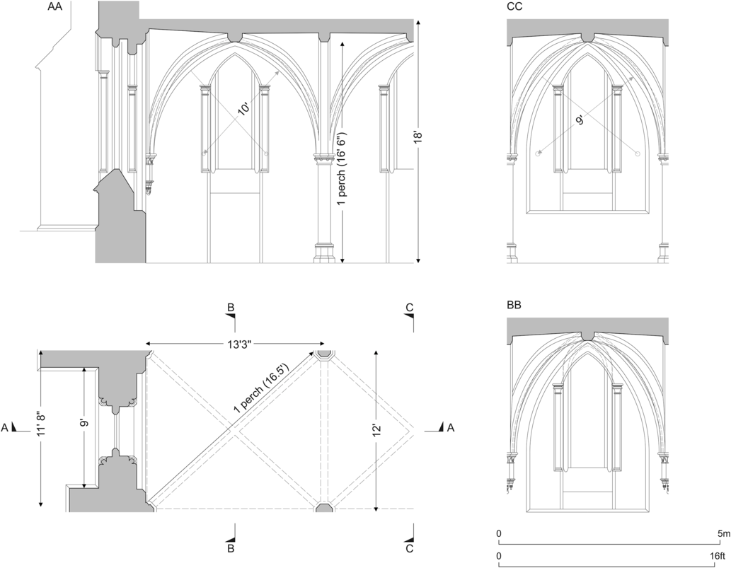
Metrical analysis of vaulting compartment and window recorded in 1900 (scale: 1:100). Image: the authors.

The foundations were neatly built of hard sandy mortar and faced with Kentish ragstone rubble; the ground level being built up around completed foundations (the floor of the vaulted chamber probably marked local ground level prior to construction). The buttress foundations were therefore very much larger than the buttresses eventually built on them. No fewer than three steps were apparent in the wall foundation: presumably minor corrections made during the process of construction. The foundation structure was mostly poured mortar, of unusual hardness for work of this period (a mark of the attention to quality typical of this building).
Internal and external facing was of rough rubble, brought to course at intervals of c 150mm (6 inches). This facing was set after the window rere-arch centring was removed. Externally, the ragstone was hammer-dressed to form rough blocks. All angles and re-entrants were dressed with Reigate stone quoins. The columns and corbel responds were cut from brown Purbeck marble. The surviving column was brought to a high polish, excepting the impost of the capital. This retains the distinctive markings of a claw-tool.
The chamfered Reigate stone plinth, to judge by its fresh appearance, was quickly buried. No render was observed in 1988; some whitewash was noted during the excavation, but this is probably post-medieval. The facing of bare Kentish ragstone was evidently deemed capable of indefinite exposure. The westernmost buttress (as observed in 1988) of the north wall was probably the second buttress of that wall (counted from the west; see fig 13). This buttress apparently projected only half the distance of its fellows, suggesting the obstructing influence of some external structure. The scar on the external wall elevation showed that the buttresses ran higher than the window apex (see fig 12).
The ashlar-work ground table (0.72m in height) was capped by a weather moulding of Reigate stone, almost completely destroyed by weathering. This was laid on a tile course (it is not clear if this weather moulding was interrupted by the buttresses or swept around them). The weather moulding was continuous with the sloping sill of a lancet window deeply set within a reveal adorned with colonnettes. Similar angle mouldings were employed within the internal embrasure but only the position of bases and capitals can be seen. A label (greatly weathered) framed the simple two-centred arch; a relieving arch of Reigate stone framed the label moulding in turn.
Moving back inside, the surviving lancet was recorded as 2ft 6in (0.76m) wide in 1900. The use of a lowered internal rere-arch relative to the outer opening allowed the glazed light to continue above the level of the vault (a glazing groove is just apparent on Smith’s plan of the window). The window was set within a recess framed with a massive two-centred arch (the arch that survives at Selsdon Park). This recess also incorporated chamfered jambs and a sill continuous with the arch; four recesses are shown in Emslie’s view (see fig 9).
(RE)CONSTRUCTING THE VAULT
The chamber was covered by a quadripartite vault with diagonal and cross ribs, no ridge rib was employed. Using the excellent survey of 1900 (see fig 8) it is possible to present a new reconstruction of the entire vaulting compartment (fig 15). Window and vault shared a common axis of symmetry in only one case (the second bay from the west). Lancets and buttresses were consistently mis-centred in relation to one another, despite their common interval.
This lack of correspondence between the vault interval and window interval cannot be put down to inadequacies in the recording. The Smith drawing (a small-scale plan in fig 8) is the only record of the overall plan of the building and seems to show three uniform bays; his elevation shows, however, that the third embrasure from the west was displaced markedly from the vault’s axis of symmetry. Why was this?
The irregular buttress spacing is particularly apparent in the third bay. The spacing was 11ft 8in (3.55m) rather than the 12ft (3.66m) consistently employed in the other bays (see fig 15). This differential was to ensure the end buttresses were in line with the gable ends, but had the effect of shortening the bays at either end. Tenuous evidence for these ‘shortened bays’ is also apparent in Smith’s drawing.
At the springing, the diagonal ribs were separate entities to the cross ribs (the tas-de-charge method was not employed). Nor were ‘spines’ present on the rib dosserets to ‘lock’ the ribs into the vault fabric. Smith’s elevation (in fig 8) shows that the westernmost (then extant) wall rib behaved differently from the window rere-arch. Norman’s watercolour (in fig 7) and Smith’s drawing agree in showing no trace of a blocked rere-arch in this bay. It is therefore possible that ‘le payer of stayers’ mentioned in the 1544 grant occupied the outer wall face at this point (the shorter buttress at this point has already been noted). No attempt has been made to show this stair in the reconstruction.
The vault rib was apparently a simple moulding with a wide soffit fillet flanked by shallow hollow chamfers. The diagonal ribs were of lighter section (230mm?) than the cross ribs (250mm?) and were structurally independent of the latter. Smith’s drawing (fig 8) shows that both ribs (and the wall recess arch) shared a 10ft (3.05m) centre (fig 15, BB, CC). Both Norman and Smith recorded the height of the cross rib from the ground as 16ft (4.88m; Norman mentions the ‘crown’ as the point of measurement, but the Smith drawing shows this measurement to be to the soffit of the rib rather than the vault web). Sixteen feet is close to a perch (16ft 6in; 5.03m), a measurement commonly used as a point of departure in later medieval church design.Footnote 30 The diagonal rib described, as is usual, a semi-circular arch; here occupying a length of 5.07m in plan (slightly more than a perch). Meanwhile the column height (2.47m) was slightly less than half a perch. These errors cancelled out: the point of vault intersection being at the ‘right’ height of a perch.
The springers of the longitudinal cross rib (at the midline of the vaulted chamber) survived in 1900; subtle differences in geometry created a canted ceiling line (fig 15: C–C, B–B). This domical or Angevin vault construction imparted some extra strength to the vault and added a sense of lightness.
As has been discussed, the complete vaulted chamber was about 55ft by 26ft (16.9m × 8.1m) internally, based on the assumption that the east end fronted onto Friar Street. No evidence of a door exists except (perhaps) in the 1702 plan. This appears to show doors at the west end of the north wall and the east end of the south wall, but their dating is unknown (see fig 5). A conjectured door opening in the west wall would give access to and from the east cloister. A double portal with much elaboration would be normal in the context, but no attempt has been made here to show this.
THE UPPER CHAMBER
Certain aspects of the upper chamber can be suggested. The behaviour of the vault rules out anything other than a single hall-like chamber (although timber partitioning may have been inserted at a later date). Allowing for the usual internal offsetting characteristic of medieval architecture, one can hazard a space some 57ft by 28ft internally (17.3m × 8.5m). The scale is reminiscent of the early fourteenth-century Guard Room at Lambeth Palace or the late fourteenth-century Hall of the Dean’s House at Westminster Abbey. This raises interesting possibilities about the purpose of this space; but in the absence of better knowledge the model presented here is chiefly reliant on documentary evidence.
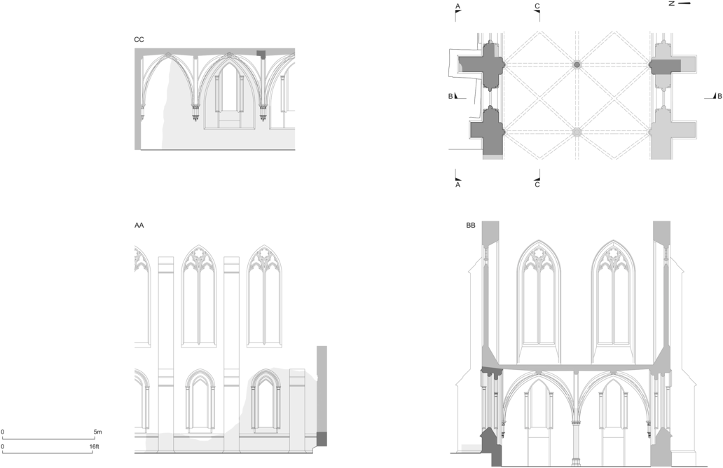
The floor surface probably lay a little over 18ft (5.5m) above the floor of the lower chamber. Traceried windows may have lit the long-axis walls, as illustrated in fig 16 (AA), while paired windows (BB) or, alternatively, single large traceried windows may have been used in the gable walls. Given the ornateness of the lower chamber, the vanished upper chamber must have been at least as ornate. The sturdy external buttresses suggest transverse stone arches supporting a timber roof (as illustrated in fig 16). A later example of this technique was employed at Guildhall in the fifteenth-century roof.Footnote 31 The entrance probably lay at the west end, giving access from the east walk of the cloister, perhaps via the ‘payer of stayers’ discussed above.
Conjectured elevation based on the areas recorded in detail in 1900, 1988 and 2011 (not separately distinguished) (scale 1:200). Image: the authors.

There is no documentary evidence to aid identification of the upper chamber. However, a new library was built at Black Friars as part of the second (southern) cloister, constructed in the middle or third quarter of the fourteenth century (a visit to the new library is recorded in the 1370s).Footnote 32 If the lower chamber served as the original chapter house, the upper hall may have been the first library. The south aspect and good light of this large upper room would certainly have made it suitable.
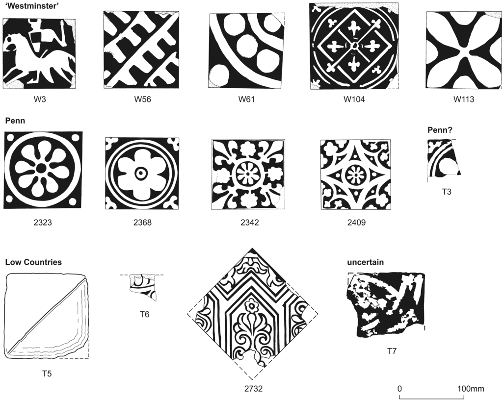
The floor of the upper or lower chambers may have been paved with ‘Westminster’ tiles: five decorated ex situ examples were found in the 1988 excavation, and some plain glazed tiles (fig 17; the tiles could also have been used in the late thirteenth-century church choir). These floor tiles were made in London (probably Farringdon) during the second half of the thirteenth century and in the first decade of the fourteenth century; they were common in London monastic houses and were used in (and named after) Westminster Abbey, including its chapter house.Footnote 33
Ex situ ‘Westminster’ floor tiles of the late thirteenth century found on the FRI88 archaeological site, perhaps originally used in the chapter house building (scale 1:6). Image: after Betts Reference Betts2017.

The London Dominican priory is probably the friary described in the late fourteenth-century poem known as ‘Pierce the Ploughman’s Crede’. In an evocative section of sixty-four lines the narrator takes the reader-listener on a tour of the friary. The poet paints a striking portrait of the Dominican chapter house:
Thanne was the chaptire-hous wrought as a greet chirche,
Corven and covered and queyntliche entailed;
With semlich selure [ceiling] y-set on lofte,
As a Parlement-hous y-peynted aboute.Footnote 34
This is not, of course, an eyewitness description of the London chapter house: it could refer to the Norwich house, or be an amalgam of several friaries; it should also be remembered that the poet is satirising the excessive splendour of the friary rather than writing a literal description of one of their houses.Footnote 35 However, this literary chapter house chamber – carved in stone like a great church and painted like the secular hall at Westminster – could equally refer to the upper or lower chambers discussed here.
EVIDENCE OF DATE AND ARCHITECT
That this building is ‘thirteenth-century work’ has always been considered self-evident.Footnote 36 The surviving column preserves sufficient data of an art-historical nature to allow a date to be suggested independent of the documentary record. The octagonal base is typical of the Decorated style: the chamfered plinth and the sub-base were used in different parts of England in the last two decades of the thirteenth century, having developed in northern France.Footnote 37 The simple double-roll base separated by a slight hollow deserves attention in this context. The round capital and distinct polygonal abacus reflect the continuing influence of continental prototypes up until c 1290: very similar capitals with projecting ribbons can be seen in the vast vault of the Salle des Gardes in the Conciergerie, Paris (1268–1314).Footnote 38 The column is also similar to the columns of the lower chapel of the Sainte-Chapelle (1244+) nearby; particularly in the detail of the base.Footnote 39
The use of Purbeck marble for entire features such as columns seems to have peaked around 1290.Footnote 40 The cutting of this stone was a distinct craft of the marbrers, who traded in completed fittings and features of this stone. This is demonstrated by identical components, such as bases, cropping up in completely different parts of the country.Footnote 41 Marked disparity between the column shaft diameter and its capital illustrates the ‘mix-and-match’ use of elements already completed elsewhere (the column diameter proved too narrow for the job). Larger capitals were obtained to correct the fault. A short drum at the top of the shaft (cut from a single piece) may represent a correction in height.
Robert of Beverley (fl. 1253–87), the king’s master mason from 1260, is normally assumed to have been the mason in charge of the early stages of the construction of the new Black Friars – particularly the choir of the church – because of his presence on a commission concerning the reconstruction of the city wall.Footnote 42 It is worth emphasising that the construction of the church, the chapter house and the new city/friary wall were all taking place in the 1280s. Robert had long involvement with the supply of Purbeck marble by the time of the re-foundation, corresponding with Richard le Wyte of Purbeck on the matter of stone for Westminster Abbey. It is worth noting that his successor at Black Friars, Michael of Canterbury, had twenty-four masons working under him there in 1312 when Edward ii visited the site (he presented the masons with gifts). The artistic reputation of Michael has been rather undervalued in the past; he has recently been described as ‘the principal begetter of the English Decorated style’.Footnote 43 He was the artist behind the Cheapside Eleanor cross (1291–4), built when the marble trade was in full swing and it is tempting to put him at Black Friars under Robert of Beverley in the 1280s.
CONCLUSIONS
This ornate two-storey friary building was constructed in the 1280s. The lower vaulted chamber – with its ground-floor setting, lavish glazing and ornate ‘Angevin’ vaulting – can be identified as the chapter house chamber, for which funding was arranged in 1281. A two-storey building of this type could well have had a double purpose, especially during the early fourteenth century when the friary cloister was not yet finished. The large upper hall may therefore have been the first Black Friars library. The most busy and fashionable masons in the land were in direct supervision of this work. It is tempting to see contemporary works in the Palais de la Cité as an inspiration to the English Court; the influence of Parisian architecture might be expected in work patronised by the English king and his courtiers.
The function or functions of the chapter house building probably began to change in the fourteenth century. The upper library – if the authors are right in their hypothesis – was probably converted into chambers in the second half of the century (after the new library was completed). The Bishop of Winchester’s great hall in Southwark shows a similar subdivision into domestic apartments by the time of the Dissolution.Footnote 44 The lower chamber – the putative chapter house – may have continued in use a little longer in its original role. A new chapter house was, however, constructed just to the north with more convenient direct access from the east wing of the cloister. There is little dating evidence for this second chapter house, although construction works are documented in the cloister and precinct in the 1480s and in the first decade of the sixteenth century.Footnote 45
This gem of the Decorated style, perhaps the building ‘wrought as a greet chirche’ according to the description of the ‘Pierce the Ploughman’s Crede’ poet, showed the architectural influence of Robert of Beverley and/or Michael of Canterbury. The building would certainly have been hard to complete without the patronage of Edward i and Queen Eleanor. The king was behind the project that rebuilt this corner of the walled city (improving the city walls and creating a new friary precinct) and he gave money to the re-founded friary. In sadder circumstances he chose the new church for the burial of his young son and former heir, Alphonso (d. 1284), and for the heart of his wife Eleanor (d. 1290).Footnote 46
Seven centuries later we can still catch glimpses of this remarkable medieval building in today’s London: the chapter house column stands beside Victorian statues in the new Dominican friary in Belsize Park, and (for the determined visitor) the rere-arch of the vaulted chamber can be found in its wooded thicket in Selsdon Park Hotel, Croydon.
The archaeological, architectural and conservation efforts of an earlier age deserve credit. A network of antiquaries and scholars put their shoulders to the wheel at the turn of the nineteenth and twentieth centuries: the architects William Arthur Webb and George Thow Smith; the archaeological artist Philip Norman FSA and the architectural historian and archaeologist Alfred Clapham FSA; the topographical artist and folklorist John Philipps Emslie; the friar-historian Raymund (born Charles Ferrars) Palmer OP; and the wealthy brewer and landowner Wickham Noakes. It is with pleasure that we build on their work.
ACKNOWLEDGEMENTS
The authors thank Diane Belshaw of Selsdon Park Hotel for granting them permission to search the grounds for the Blackfriars arch. They also thank Father Thomas Skeats OP of St Dominic’s Priory, London, for allowing them to record and photograph the medieval column in the friary church; Andy Chopping of MOLA took the photograph in fig 10. Geoffrey Scott OSB, abbot of Douai Abbey, kindly allowed access to the Douai Abbey Archive. Carlos Lemos prepared the figures for publication from the authors’ CAD drawings; the figures incorporate MOLA digital material (with thanks to David Bowsher). The authors gratefully acknowledge the financial assistance of the City of London Archaeological Trust and the London and Middlesex Archaeological Society.
ABBREVIATIONS AND BIBLIOGRAPHY
Abbreviations
- CAD
-
computer-aided design
- CCR
-
Calendar of Close Rolls
- CPR
-
Calendar of Patent Rolls
- LAA
-
London Archaeological Archive, London
- LCC
-
London County Council, London
- LMA
-
London Metropolitan Archive, London
- MOLA(S)
-
Museum of London Archaeology (Service), London
- NGR
-
National Grid Reference
- TNA
-
The National Archives, London