Archaeological evidence of ancient agricultural fields is often preserved as subtle traces on the landscape, including field boundaries, clearance mounds, infilled irrigation channels, and anthropogenic soils. Analysis of these and other ancient agricultural features has been shown to be a powerful means to understand issues ranging from political economies and environmental entanglements to ideologies of land, labor, and gender (Crumley Reference Crumley, McIntosh, Tainter and McIntosh2000; Erickson Reference Erickson2010; Hastorf Reference Hastorf2017; Lentz Reference Lentz2000; Miller and Gleason Reference Miller and Gleason1994; Morrison et al. Reference Morrison, Feinman, Nicholas, Ladefoged, Myrdal-Runebjer, Stone and Wilk1996; Wilkinson Reference Wilkinson2003). Yet, in North American archaeology, discovery and documentation of precolumbian and historic Indigenous agricultural fields remains relatively less common, aside from a few notable examples, such as the irrigation works in the American Southwest (Eiselt et al. Reference Eiselt, Darling, Duwe, Willis, Walker, Hudspeth and Reeder-Meyers2017; Fish Reference Fish and Lentz2000; Fish and Fish Reference Fish and Fish2007); raised field, chinampa systems in northern Basin of Mexico (Morehart Reference Morehart2012) and Gulf lowlands (Stoner Reference Stoner2017); Mayan agricultural terraces (Adams et al. Reference Adams, Brown and Culbert1981; Chase et al. Reference Chase, Chase, Weishampel, Drake, Shrestha, Clint Slatton, Awe and Carter2011); and remnant raised fields in Wisconsin (Gartner Reference Gartner2003; Sasso Reference Sasso, Jeske and Charles2003). Direct landscape evidence for precolumbian fields is surprisingly hard to find given numerous historical accounts that detail expansive fields across North America (Doolittle Reference Doolittle2000). This lack of data has served to reinforce the pristine myth of American landscapes (Denevan Reference Denevan1992), and it creates a stumbling block to building a more complete understanding of the scope, intensity, and character of precolumbian agricultural practices.
In the western Great Lakes, archaeologists have long noted remnants of a relatively widespread agricultural landscape evidenced by the presence of raised fields that consist of ridges and small earthen mounds, which are termed “corn hills.” Fields are typically found adjacent to or surrounding settlement sites, and they can be associated with other earthworks, including thousands of Late Woodland period (AD 700–1100) effigy mounds (Gartner Reference Gartner1999). Many archaeological Indigenous agricultural systems and other earthworks were documented during the late nineteenth century, before being destroyed by Euro-American settlement and farming. These more recent agricultural practices ultimately resulted in extreme levels of soil erosion and deep sedimentation in valley bottoms (Knox Reference Knox1977, Reference Knox2001; Trimble Reference Trimble2016) and—combined with other forms of land use—are believed to have destroyed much of the archaeological landscape, such that only a fraction of the features visible in the nineteenth century are extant today (Gartner Reference Gartner1999, Reference Gartner2003). Moreover, because prehistoric ridged fields, corn hills, and associated earthworks were once commonly located on prime agricultural lands, what remains of these landscapes today is found almost exclusively in marginal agricultural spaces—such as protected forests and ridge tops—as these are the only places left relatively unaffected by modern farming practices and other forms of development. Today, extant mounds, fields, and other cultural features are generally treated as discreet sites in both academic literature and state records. But the intensive use of these spaces since Euro-American settlement and resultant impacts from erosion, farming, and development means that historical or modern records of the sites are unlikely to capture the full extent or complexity of the archaeological landscape (Howey and Brouwer Burg Reference Howey and Burg2017; McCoy Reference McCoy2020:518).
This article presents investigations into the viability of using historical aerial photographs from the 1930s to document prehistoric and historic Indigenous agricultural fields and other related features in southwestern Wisconsin. Archaeological research in other parts of the world has long relied on analyses of historical aerial and satellite imagery dating from the early to mid-twentieth century as a means to discover, map, and interpret archaeological sites and features that have been obscured or destroyed in recent decades (e.g., Casana Reference Casana2014; Casana et al. Reference Casana, Cothren and Kalayci2012; Hammer and Ur Reference Hammer and Ur2019; Hanson and Oltean Reference Hanson, Oltean, Hanson and Oltean2013; Musson et al. Reference Musson, Palmer and Campana2013; Soroush Reference Soroush2016; Stichelbaut Reference Stichelbaut2006; Stichelbaut and Bourgeois Reference Stichelbaut and Bourgeois2009; Ur Reference Ur2013). While historical imagery is more rarely employed in North American archaeology, several studies demonstrate the power of historical aerial photography to reveal archaeological landscape features in the United States (e.g., Bitely Reference Bitely2013; Clark and Casana Reference Clark and Casana2016; McLeester et al. Reference McLeester, Casana, Schurr, Chad Hill and Wheeler2018; Vogel Reference Vogel2005). Within the American Midwest, however, intensive residential, commercial, agricultural, and industrial development—sometimes predating the earliest aerial imagery—poses significant challenges.
Leveraging a comprehensive database of high-resolution U.S. Department of Agriculture aerial photographs dating to the 1930s alongside both modern aerial imagery and public lidar data for this pilot study, we systematically analyze sites within counties of the Wisconsin River drainage basin where archaeological agricultural features had previously been recorded. As a check on this strategy, we analyze a sample of contemporaneous, larger Woodland sites where agricultural features were not recorded. As in many parts of eastern North America, the first aerial photographic mapping, undertaken across the United States during the 1920s and 1930s, captured images of the landscape prior to the most severe impacts of recent urban, residential, agricultural, and industrial development or obscuration by the growth of secondary forest. At the same time, however, the well-documented, largely Euro-American agricultural intensification that took place in the region from the 1880s onward destroyed much of the preexisting archaeological record. Nonetheless, our results demonstrate that for more than a quarter of the sites we examined, archaeological agricultural features can be resolved in historical imagery. In several cases, we have been able to recognize previously unknown or incompletely documented elements of the landscape, including ridged fields, corn hills, and effigy mounds. Results therefore demonstrate the potential of historical aerial imagery analysis to recover otherwise lost archaeological evidence of precontact and historic Indigenous land use, creating a more complete and nuanced picture of archaeological landscapes that incorporates a broader range of past Indigenous cultural features. Moreover, the landscape-scale cultural features detected further illustrate the connectivity fundamental to landscape thinking and the need to “unbind” archaeological analyses from the site concept (Howey and Brouwer Burg Reference Howey and Burg2017:4). Last, with historical imagery from the 1920s and 1930s available for most of the United States, the methodology we develop in this study is broadly applicable to similar investigations elsewhere in the country.
Precontact and Historical Indigenous Agricultural Landscapes of the Upper Midwest
For this study, we selected agricultural spaces in Wisconsin because the state has the largest number of documented precontact and historic Indigenous ridged and hilled field systems within the Midwest—over 450 recorded fields concentrated most densely in the southwestern portion of the state (Gartner Reference Gartner2003). Wisconsin also maintains and makes accessible expansive historical records, with better documentation from the nineteenth century of sites and features than other Midwestern states (e.g. Gartner Reference Gartner2003; Lapham Reference Lapham1855), as well as provides easy access to historical aerial photographs and high-resolution lidar. Although we recognize the wide variety of Indigenous agricultural spaces in eastern North America (Abrams Reference Abrams2010; Abrams and Nowacki Reference Abrams and Nowacki2008; Doolittle Reference Doolittle2000; McLeester Reference McLeester2017; Mt. Pleasant Reference Mt. Pleasant2015; Scarry and Scarry Reference Scarry and Scarry2005), this study investigates only archaeological field systems constructed for maize-intensive agriculture, from AD 900 through the Indian Removal period (AD 1796–1840), because these types of fields are the most likely archaeological forms of Indigenous agriculture to be identified in aerial imagery.
Ridged and hilled field systems were constructed in Wisconsin beginning in the Late Woodland period (ca. AD 900), and they became widespread by AD 1150 (Gartner Reference Gartner1999), coinciding with the adoption of more intensive maize cultivation. Palynological and charred plant remains confirm that these fields were primarily used to cultivate maize, beans, and squash with additional, variable plants cultivated alongside them (Gallagher and Sasso Reference Gallagher and Sasso1987). Agricultural fields in Wisconsin were located in every ecological zone (Gartner Reference Gartner2003), and they varied in size from <1 ha to 121 ha (Gallagher Reference Gallagher and Woods1992). Most fields in the Great Lakes region likely fell in the middle range of 8–40 ha (Fowler Reference Fowler and Woods1992). The largest excavated ridged field in the region is within the Sand Lake site (47Lc44) in southwestern Wisconsin, which contains over 600 m of ridges and covers an area of 5.3 ha (Gallagher Reference Gallagher and Woods1992:115).
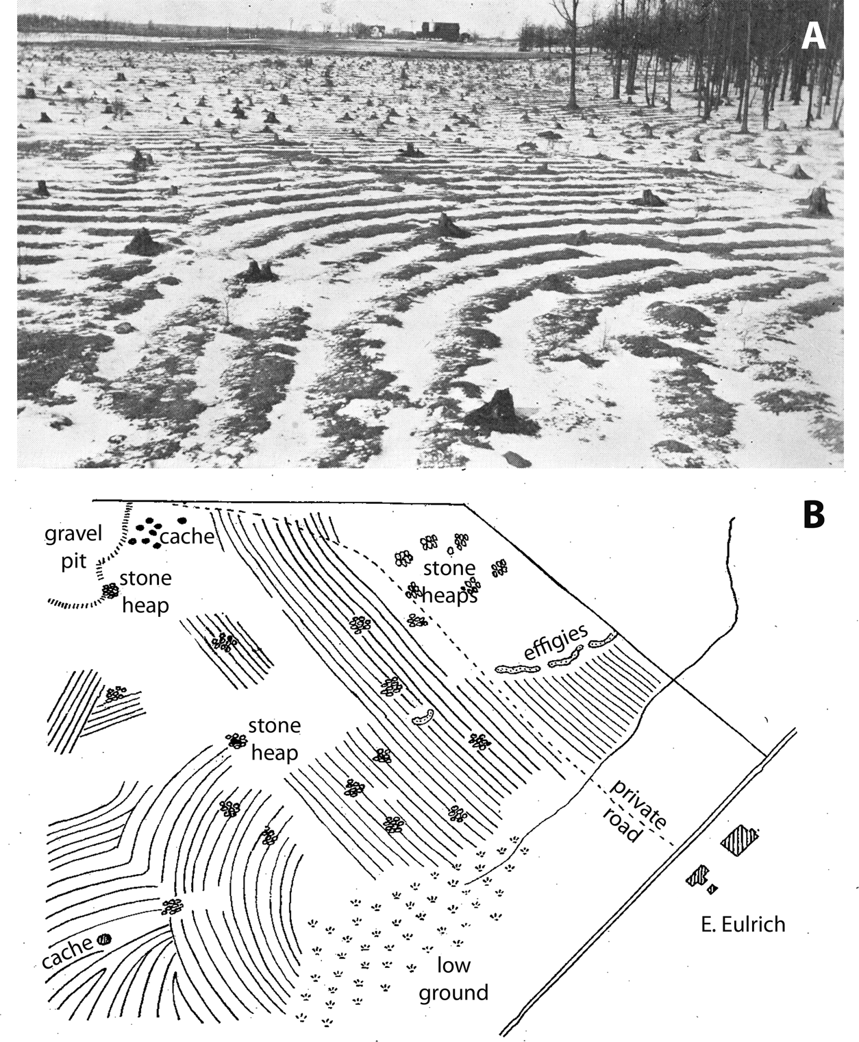
Archaeological fields vary significantly in size and arrangement of ridges and/or corn hills, suggesting that they were constructed based on local traditions or preferences (Gartner Reference Gartner2003). For ridges, average sizes range from approximately 30 m to 38 m in length, 1 m to 2 m in width, and 0.15 m to 0.2 m in height (Gallagher Reference Gallagher and Woods1992:101). Ridges could be up to 3.5 m wide and over 100 m long. They were arranged in parallel and/or intersecting rows aligned within straight or curved fields (Fox Reference Fox1916, Reference Fox1959; Figure 1). Corn hills were approximately 1 m in diameter and ranged from 0.05 m to 0.4 m high, and were arranged in rows or scattered (Sasso Reference Sasso, Jeske and Charles2003:198).
Photograph and sketch map of ridged fields at the Eulrich site (47Wn215) in Winnebago County, Wisconsin (Fox Reference Fox1922:Plates 1 and 2). Images courtesy of The Wisconsin Archeologist, text enlarged from original in (B). Scale and orientation are not known.

Extensive field systems are part of broader archaeological landscapes and situated among multiple cultural features. The most visible of these in the aerial imagery are earthworks, especially effigy mounds. Part of the long tradition of mound construction in North America, effigy mounds are earthworks that resemble animals, people, or other geometric shapes, which were built during the late Late Woodland period (ca. AD 700–1100) and are found primarily in Wisconsin and adjacent parts of Iowa, Illinois, and Minnesota (Rosebrough Reference Rosebrough2014). Typically low to the ground and around 30 m in length, thousands of effigy mounds were constructed over a 400–500-year period. In southern Wisconsin alone, over 3,000 effigy mounds have been recorded, and many others have likely been lost to erosion or farming prior to being documented (Birmingham and Rosebrough Reference Birmingham and Rosebrough2017). Although an analysis of effigy mounds exceeds the scope of this article, their intermingling with agricultural features, obvious visibility in aerial imagery, and historical destruction resulted in the inclusion of select mounds when detected.
Methods
Because historical aerial and satellite imagery preserve a picture of the earth's surface that often predates major land use changes seen in recent decades, analysis of these images has proven to be a uniquely powerful means to explore archaeological landscapes in many parts of the world (e.g., Hanson and Oltean Reference Hanson, Oltean, Hanson and Oltean2013). Archaeologists working in Europe, for example, have made use of the relatively rich archives of aerial imagery available there, some dating as early as the First World War, to undertake a wide variety of studies (e.g., Musson et al. Reference Musson, Palmer and Campana2013; Oltean Reference Oltean, Hanson and Oltean2012; Ortega and Sanchez-Pardo Reference Ortega, Sanchez-Pardo, Hanson and Oltean2012; Stichelbaut Reference Stichelbaut2006; Stichelbaut and Bourgeois Reference Stichelbaut and Bourgeois2009; Tartara Reference Tartara, Hanson and Oltean2012; Visy Reference Visy, Hanson and Oltean2012; Young Reference Young, Hanson and Oltean2012). In other parts of the world, where historical aerial photography does not exist or remains inaccessible to researchers (for example, the Middle East and Central Asia), archaeologists have made extensive use of declassified intelligence satellite imagery. This includes CORONA from the 1960s to 1970s (Beck et al. Reference Beck, Philip, Abdulkarim and Donoghue2007; Casana Reference Casana2014, Reference Casana2020; Casana and Cothren Reference Casana, Cothren, Comer and Harrower2013; Casana et al. Reference Casana, Cothren and Kalayci2012; Challis et al. Reference Challis, Priestnall, Gardner, Henderson and O'Hara2004; Kennedy Reference Kennedy1998; Kouchoukos Reference Kouchoukos2001; Philip et al. Reference Philip, Donoghue, Beck and Galiatsatos2002; Soroush Reference Soroush2016; Ur Reference Ur2013) and, more recently, U-2 spy-plane images from the 1950s (Hammer and Ur Reference Hammer and Ur2019) and earlier intelligence photographs (Stott et al. Reference Stott, Kristiansen, Lichtenberger and Raja2018). In the United States, aerial photographs have been collected systematically since the 1920s over virtually the entire country by state and federal agencies, and a handful of archaeological studies have made use of this rich resource (e.g., Bitely Reference Bitely2013; Clark and Casana Reference Clark and Casana2016; Johnson Reference Johnson, Ahler, Hass and Bonani2007; McLeester et al. Reference McLeester, Casana, Schurr, Chad Hill and Wheeler2018; Vogel Reference Vogel2005). Although the United States Geological Survey (USGS) makes a sample of historical aerial images available in digital format on its EarthExplorer data distribution platform, the majority of the existing archive of historical imagery for the United States remains difficult to access because it exists only in analog format, and there is no mechanism to efficiently search or digitize the film.
Historical aerial photographs used in this study were collected from 1936 to 1938 by the U.S. Department of Agriculture (USDA), and they are publicly available through the Wisconsin State Cartographer's Office (SCO) open-access data distribution portal, the Wisconsin Historic Aerial Imagery Finder. Photographs were collected on standard 9 × 9-inch aerial film, at 60% overlapping coverage, at a scale of 1:20,000, producing relatively high-resolution imagery of <1 m ground-sample distance—a resolution that is required to see many archaeological features. The digital versions of USDA imagery provided by the state of Wisconsin were scanned by the cartographer's office from contact print film copies of the originals, at 8-bit depth and 20 micron resolution on a standard flatbed scanner. In most cases, summaries of camera calibration reports with laboratory-measured focal length and related data are also provided. Research has demonstrated that when using archival aerial film, it is possible to improve geometric accuracy during orthorectification and to photogrammetrically derive more robust digital surface models if images are digitized using a specialized aerial film scanner (Sevara Reference Sevara2016). Similarly, scanning images at higher spatial resolution and greater bit depth can improve results considerably (Sevara et al. Reference Sevara, Verhoeven, Doneus and Draganits2018). In this case, we did not have access to the original films, only to scanned copies of them. Consequently, the images have distortions caused by the scanning process as well as from stretching, warping, or other deformations of the film itself, and the scanning resolution at 20 microns is probably suboptimal. The images also contain occasional marks by pen, fingers, dust, and water damage, which is common on archival film. Despite these limitations, the scanned aerial films are generally of high quality, and the state of Wisconsin deserves enormous credit for making them available to researchers through a user-friendly portal.
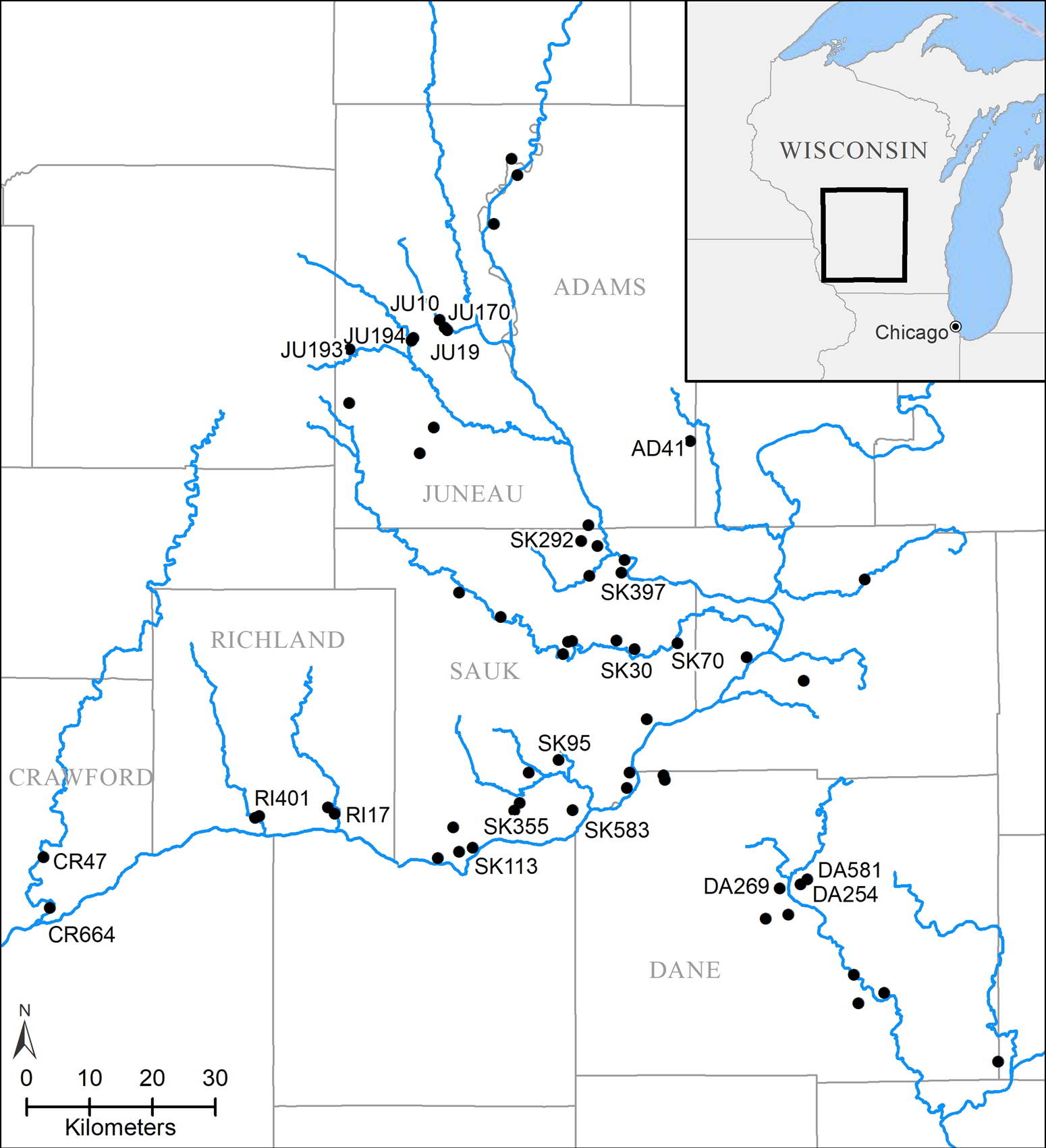
Here, we make use of the publicly available 1930s aerial imagery to analyze 59 sites within the Wisconsin River drainage basin in southwestern Wisconsin, where state records indicate previous identification of agricultural features located in Adams, Columbia, Crawford, Dane, Grant, Juneau, Richland, and Sauk counties (Figure 2). Archaeological investigations, primarily during the late nineteenth and early twentieth centuries, had noted the presence of garden beds, ridged fields, or corn hills at each of these sites or in the immediate vicinity. We selected the study sites through an analysis of more than 6,000 site records contained within the Wisconsin Historic Preservation Database Archaeological Sites Inventory, as well as by consulting Gartner's (Reference Gartner2003) detailed treatment of field systems in Wisconsin. All sites in the Wisconsin Sites Inventory have descriptions transcribed from original site record forms, as well as an associated polygon contained within a shapefile obtained from the Wisconsin Historical Society, which makes the incorporation of data into geospatial projects like ours comparatively straightforward. For each site in question, we acquired 1930s historical USDA aerial photographs, modern high-resolution USGS aerial imagery, and publicly available lidar data, and then we carefully examined each dataset, iteratively looking for potential archaeological agricultural features. Because agricultural features often extend well beyond official site boundaries, we use site polygons as a starting point for analysis, searching for potential archaeological field systems within an approximately 2 km radius of the site itself.
Locations of archaeological sites analyzed. Labeled sites indicate those with cultural features identified in aerial imagery, lidar, or discussed in this article. Data courtesy of the Wisconsin Historic Preservation Database Archaeological Sites Inventory. Image by Carolin Ferwerda.

In order to incorporate scanned 1930s aerial images into a GIS-based analysis, they must first be processed to remove spatial distortions and then georeferenced. For each of the sites in this study, we downloaded six or more overlapping images that would cover the entire site area as represented by the Wisconsin Historic Preservation Database polygon and the surrounding landscape. Using now well-established methods (see Sevara et al. Reference Sevara, Verhoeven, Doneus and Draganits2018), these images were processed in Agisoft Metashape to produce an orthoimage mosaic and a digital surface model, which were georeferenced using ground control points derived from modern high-resolution aerial imagery. Processing historical aerial photographs in Metashape prior to georeferencing means that only three to four ground control points are needed for each orthomosaic. This is key because, in many cases, there have been such extreme landscape changes that it can be difficult to find common points in historical and modern imagery in a given photograph. As discussed above, the manner in which the original films were scanned likely introduces some spatial error into the orthoimagery we produce. The accuracy we achieve using our relatively straightforward and expedient process, however, is more than adequate for the purposes of this study.
For comparative purposes, we also downloaded modern high-resolution aerial orthoimagery from the USGS Earth Resources Observation and Science (EROS) archive, all of which are freely available via EarthExplorer and distributed as georeferenced orthoimage tiles. We also compared archival imagery to modern orthoimage mosaics provided by ESRI, which are compiled from a variety of high-resolution satellite sensors. Modern aerial and satellite imagery are critical to revealing the ways in which the landscape has changed, as well as sometimes helping to interpret features visible on historical imagery.
Finally, we compared all sites and potential archaeological features against publicly available lidar data, made available by the Wisconsin State Cartographer's Office and the University of Wisconsin–Madison through their WisconsinView Data Portal. As numerous other U.S. states do, Wisconsin freely distributes lidar-derived digital elevation models (DEMs) for the entire state, but it also offers data as both a filtered and processed bare-earth DEM at 1 m ground sample distance (GSD), as well as raw LAS files for more advanced applications. These data have already been shown to be a powerful means of visualizing extant effigy mounds in Wisconsin and Iowa (Boszhardt et al. Reference Boszhardt, Harris, Schmitt, Theler, Wyse and Benden2018; Whittaker Reference Whittaker2020), so we hoped to also provide evidence of these features in our study, particularly for sites obscured by forest or other dense vegetation.
For each of the sites in this study, we then meticulously scrutinized the imagery, attempting to identify features that correspond in size, shape, and orientation with examples of ancient field systems and other regionally known archaeological features. Through a recursive process of analysis and frequent comparison to both more recent aerial imagery and lidar data, we have ultimately been able to identify the signature of several different kinds of archaeological features successfully. They are described in more detail below.
Results
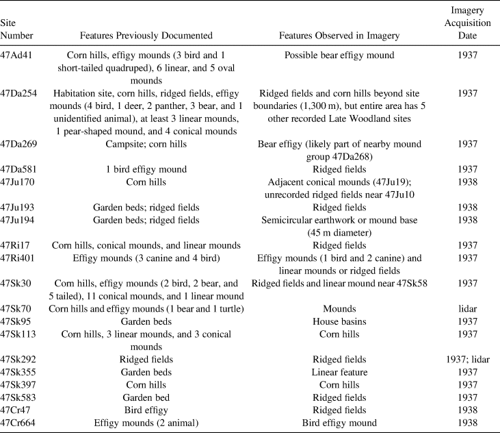
Our analysis succeeded in locating both known and previously unrecorded ridged fields, corn hills, effigy and other mounds, house basins, and other probable archaeological features at or near 19 of the 59 sites we investigated in this study (Figure 2; Table 1). Of these sites, only five are known to have extant features because the remaining majority have been destroyed by urban development, industrialized agriculture, or reservoir construction, which highlights the largely underappreciated value of historical aerial imagery for archaeological research in the region. Each site where archaeological features are resolvable is summarized in Table 1, and below, we discuss particular types of features and our relative confidence in their identification.
Summary of Archaeological Features Located at Analyzed Sites.

Ridged Fields
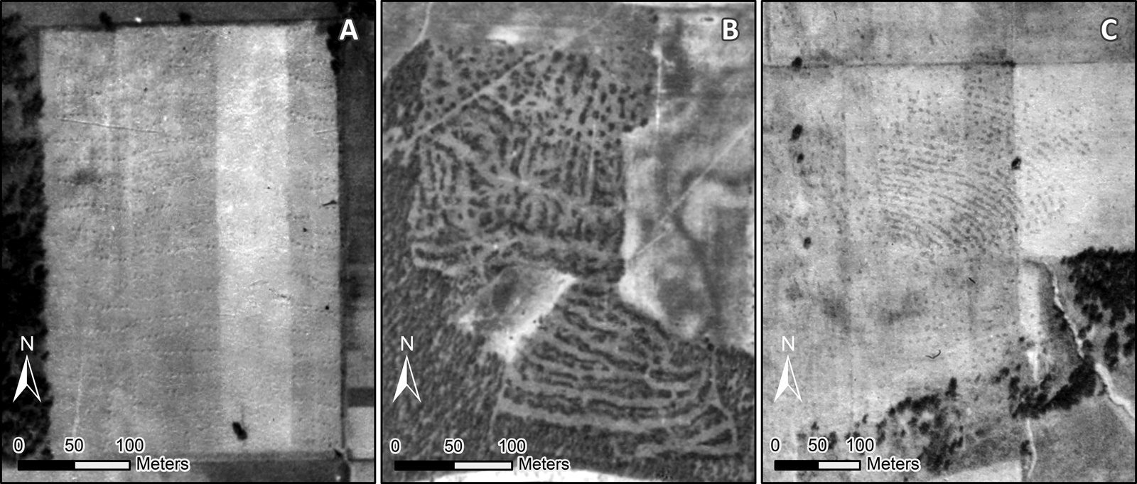
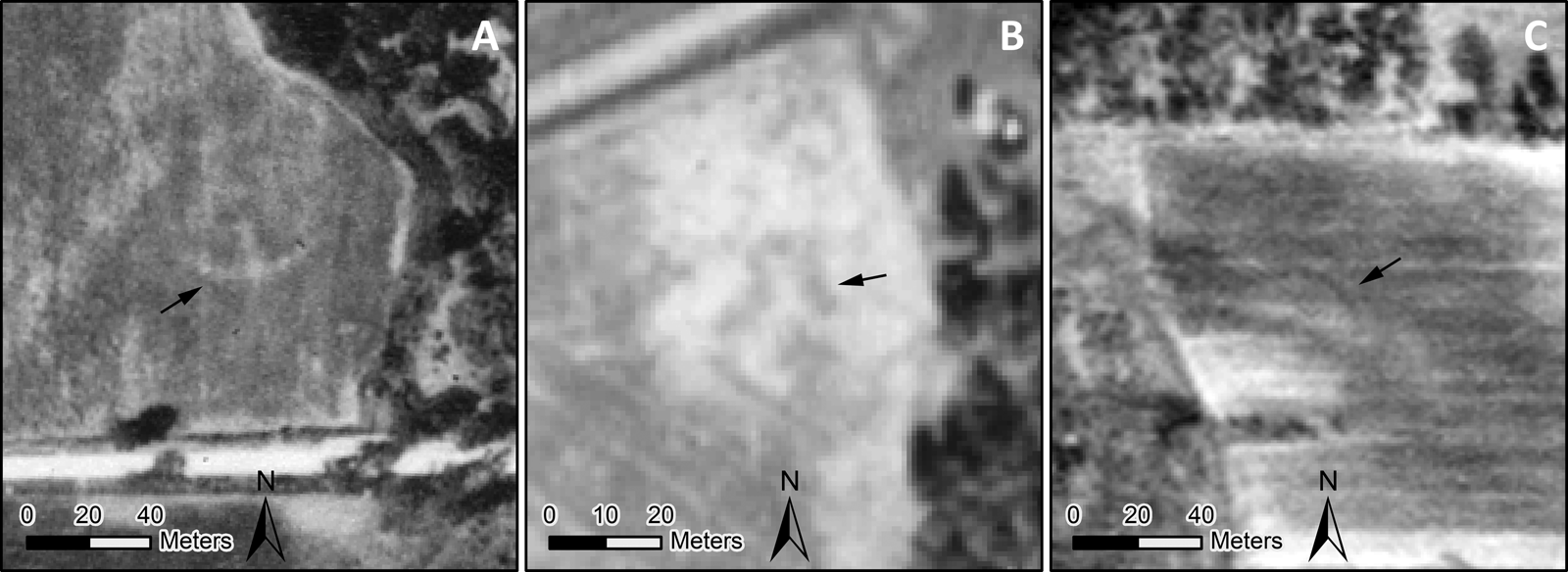
The size and character of archaeologically documented ridged fields—measuring 1.0–3.5 m in width, up to 100 m in length, and often covering large areas of the landscape—led us to assume at the outset of our study that they would be among the most recognizable features in 1930s aerial imagery. The high variability in the size, shape, and patterning of Indigenous ridged and hilled fields in Wisconsin (Gartner Reference Gartner2003), however, creates unique challenges for recognizing them. This led, initially, to numerous false positive identifications because we sometimes mistook 1930s landscape features or markings on film for archaeological agricultural features. For example, recently mowed or hayed fields, which are common in the dairy-producing landscape of 1930s Wisconsin, frequently appear in imagery because aerial photographic missions in the area were often undertaken during September or October, and the linear features that this practice produces mimic the expected pattern of ancient fields fairly closely (Figure 3a). Hay bales and haying lines, however, can be readily distinguished from ancient fields because they also conform to the area and orientation of 1930s field boundaries, and even more importantly, they are not evident on other imagery taken earlier or later in time. Linear features also occasionally appear to be related to more recent forestry practices, as in an example from Juneau County near 47Ju346: tree clearance proceeded in lines, creating linear patterns superficially similar to some ridged fields (Figure 3b). These 1930s tree clearance lines, however, are framed by and conform to the paths of contemporary trackways. In other instances, fingerprints on the film itself have darkened along ridge lines, and at the scale of the images in question, they mimic the appearance of known ridged field systems in both size and shape (Figure 3c). Such markings, however, do not appear on overlapping adjacent photos from the same aerial missions, allowing them to be readily discounted. In this study, we follow a fairly conservative approach, noting where we are uncertain about identifications and focusing on only those cases where our analysis leaves little doubt regarding the nature of the features in question—where field systems can be recognized on multiple imagery sources or cannot be explained as the product of more recent land use or agricultural practices.
Examples of features that appear deceptively like archaeological field systems in the historical aerial imagery: (A) haying lines and stacks, (B) forestry practices, and (C) fingerprints on film. Images courtesy of the Wisconsin Historic Aerial Imagery Finder.

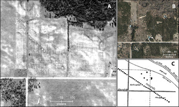
Perhaps the most striking case of ridged fields was identified during our analysis of 47Ju170, a field site adjacent to 118 Mounds (47Ju19)—a long, linear arrangement of Woodland conical mounds. The mound site itself was mapped in 1918 by Ira Buell (Reference Buell1918:121; Figure 4c), who identified 42 mounds in a line and lamented the destruction of other mounds by agricultural activities. The conical mounds Buell recorded appear clearly in 1930s imagery (Figure 4a), alongside a secondary parallel line of smaller mounds not documented by him. Although historical imagery offers an improved perspective on the nature of this impressive archaeological feature, no field systems are visible in its vicinity. Today, much of the site has been destroyed or obscured by modern development, agriculture, and secondary forest regrowth (Figure 4b).
118 Mounds site (47Ju19) as it appears (A) in 1938 aerial imagery, (B) in modern high-resolution imagery, and (C) as mapped in 1918 during an investigation (Buell Reference Buell1918:121), image courtesy of The Wisconsin Archeologist. Some text added to original, and there is no scale on the original. Sources: (A) Wisconsin Historic Aerial Imagery Finder and (B) ESRI, DigitalGlobe. (Color online)

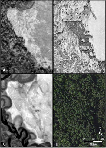
Following the line of mounds approximately 1.5 km NW, however, a series of well-preserved ridged fields is visible along low hills adjacent to the Little Yellow River near 47Ju10, an effigy mound site (Figure 5a). These clear examples of previously undocumented ridges measure approximately 2 m in width. Each ranges from 50 m to 90 m in length and appears as dark and light banded features, presumably due to differences in pedogenesis and plant growth produced by the construction of the ridged fields. This small area of preserved ridges is located on less agriculturally viable land due to its topography, and it likely represents simply the best-preserved portion of what was once a much more extensive system. By the 1960s, the fields are no longer visible in aerial imagery because forest and shrubs began to regrow in this former pasture land (Figure 5b), and although the area is completely reforested in 2019 imagery (Figure 5d), the northern half of the field system remains resolvable in bare-earth lidar data (Figure 5c), confirming that these features represent archaeological field systems and are likely intact.
Ridged field systems preserved near 47Ju10, appearing on (A) a 1938 aerial image, (B) a 1961 aerial photograph, (C) 1 m bare-earth lidar data, and (D) modern high-resolution satellite imagery. All images are of the same location, at the same scale and orientation. Sources: (A) Wisconsin Historic Imagery Finder, (B) USGS, (C) State Cartographer's Office, University of Wisconsin-Madison, and (D) ESRI, DigitalGlobe. (Color online)

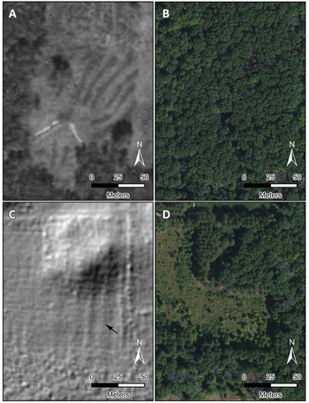
Another case in which ridged fields are evident in historical 1930s imagery is at the intact Hulburt Creek site (47Sk292), where some 80 ha of ridged field systems had previously been mapped, excavated, and radiocarbon dated to around AD 1000 (Gartner Reference Gartner1999, Reference Gartner2003). These fields measure 1–2 m in width, with planting surfaces 10 m or longer, but with just 0.3 –0.4 m of topographic expression. Imagery analysis shows that although much of the site was covered in forest as early as the 1930s, linear field systems are evident just south of the official site boundary (Figure 6a). In this case, the raised fields are somewhat more haphazard in plan and appear to be influencing vegetation growth, which enhances their visibility. Two hundred meters to the west, another segment of ridged fields is visible in lidar data. This appears as tightly spaced, linear topographic features (Figure 6c), even though today essentially all of the extant field systems at Hulburt Creek are completely obscured by forest (Figures 6b and 6d).
Hulburt Creek (47Sk292) ridged fields: (A) 1937 aerial image showing ridged fields, (B) modern high-resolution satellite imagery, (C) 1 m bare-earth lidar data from a separate section of the site with arrow pointing to one of the ridges, and (D) modern high-resolution satellite imagery of this section. Sources: (A) Wisconsin Historic Imagery Finder, (B, D) ESRI, DigitalGlobe, and (C) State Cartographer's Office, University of Wisconsin-Madison. (Color online)

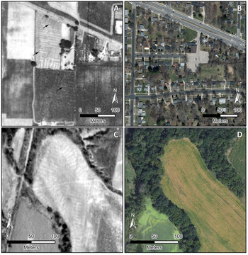
The Mendota State Hospital Mound Group site (47Da254) in Madison provides another possible yet more uncertain example of ridged fields (Figure 7a). Situated on a small peninsula on the north shore of Lake Mendota, state records document a dense concentration of Late Woodland settlement and effigy mound sites, including some with agricultural features. Although today the entire Madison area has come under intensive development (Figure 7b), the observed area surrounding the site was largely agricultural in the 1930s. In one field, a series of linear features and several small dots are visible in 1930s imagery and may represent remains of a ridged and hilled field system. The features are 1–2 m in width, they have the appropriate length, and they do not conform to the 1930s field boundaries, indicating that lines are not the result of haying. There are also faint traces of features observable in the same image with a similar arrangement in the plowed field to the south, suggesting possible relict ridged fields, which are most visible on a small plot reserved for pasture. This interpretation remains difficult to resolve, however, because no other imagery is available for the area prior to the construction of the housing division. Consequently, this example remains somewhat enigmatic.
Possible ridged fields appearing at the Mendota State Hospital Mound Group (47Da254) in (A) 1937 aerial photograph, with arrows pointing to ridges and hills and (B) modern 2014 aerial imagery; and at Nine Mile Swallow (47Cr47) in (C) 1938 aerial photograph and (D) modern 2014 aerial imagery. Sources: (A, C) Wisconsin Historic Aerial Imagery Finder and (B, D) Wisconsin Department of Natural Resources. (Color online)

Similarly, at the effigy mound site, Nine Mile Swallow (47Cr47) in Crawford County, a series of linear features that closely resemble ridged fields is visible in 1930s imagery on a gently sloping hill above the Kickapoo River (Figure 7c). Although these features may be relict fields, it is difficult to distinguish them from 1930s haying marks, and today, the area is obscured by forest cover and recent agricultural efforts (Figure 7d).
In several other cases—including 47Ri17, 47Ri401, and 47Sk58—cultural features are visible, but the co-occurrence and variability of dimensions associated with ridged fields and linear mounds makes it nearly impossible to distinguish one from another. Because of the relative isolation of linear mounds compared to the grouping of ridges, we interpret these cases as likely ridges.
Corn Hills
Corn hills are generally more challenging to detect than ridged fields in historical aerial photographs, primarily because they are often too small to be visible at the resolution of available imagery. The dimensions of archaeologically documented corn hills are approximately 1 m in diameter and about 0.3 m in height—as, for example, at an intact corn hill field in Ontario, where hill widths measure between 0.76 m and 1.27 m (Heidenreich Reference Heidenreich1974). Although some corn hills may have been larger due to additions of soil (Gartner Reference Gartner2003), most of these features fall below the threshold of visibility in our approximately 1 m ground resolution imagery. In some instances, however, corn hills are nonetheless visible. This is possibly due to the erosion and spreading of the mound, a clustering of several mounds together, or possibly localized traditions of constructing somewhat larger corn hills and accretional mounding (Gartner Reference Gartner2003).
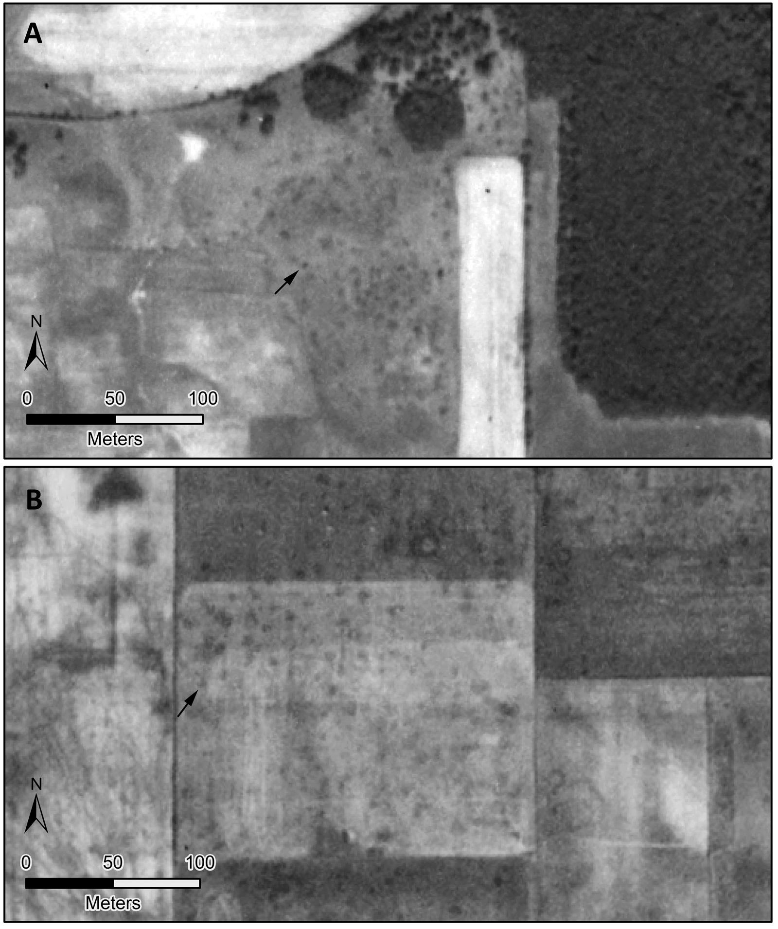
In our study, we observed features best interpreted as corn hills at three sites: 47Da254, 47Sk113, and 47Sk397. The clearest example of corn hills is located at 47Sk113, a site originally noted for the presence of several effigy and conical mounds. When the site was visited in 1922, hundreds of corn hills were reported “about the mounds, in almost every direction” (Cole Reference Cole1922:109). Aerial imagery from 1937 shows extensive traces of small, dark dots measuring 2–4 m in diameter, which are found in patches in every direction from the measured boundaries of the site over an area of several square kilometers (Figure 8b). Lines of dots can be traced for tens of meters. They cross-cut and are oriented differently from the 1930s field boundaries, demonstrating that they predate the 1930s agricultural landscape. Although the dimensions of these dots are larger than most previously documented corn hills, Gartner argues for flexible understanding of raised garden beds generally, stating that “at some sites, small corn hills became large corn hills and eventually ridged fields over the course of successive planting seasons” (Reference Gartner2003:11). The dots are unlike features seen elsewhere in any of the hundreds of images examined for this project, and they appear on multiple images of the same area, which both indicates that they are not imperfections on the film and strengthens our interpretation of the features as Indigenous corn hills. It is fortunate that these likely agricultural features are captured in aerial imagery given that the earthworks had already been destroyed at 47Sk113 by 1922, and when the site was revisited in 2018, no cultural features were found to be preserved.
Examples of corn hills in two separate locations in 1937 images near (A) the Steele Cornfields (47Sk397) and (B) the Williams Mound site (47Sk113). Arrows point to examples of corn hills in both images. Images courtesy of the Wisconsin Historic Aerial Imagery Finder.

We also observed similar features that we interpret as corn hills at two other sites—47Da254, where corn hills appear to be located in association with ridges, and 47Sk397, where a dense cluster of small dark dots is evident on an elevated landform just to the east of the site—above the adjacent river (Figure 8a). The multiple appearance of these small dots at sites where corn hills were reported increases our confidence in our interpretation of these otherwise subtle features.
Effigy Mounds and Other Features
Although this study is primarily dedicated to documenting agricultural features, in the course of our analysis we also encountered mounds at seven sites (47Ad41, 47Da269, 47Ju170, 47Ri401, 47Sk70, 47Sk30, and 47Cr664) and other two other earthwork features: a faint semicircular earthwork at 47Ju194 and a linear feature that cut across multiple 1930s fields near 47Sk355.
Effigy mounds, perhaps the most well-known and iconic mound type in the Midwest, have recently been shown to be resolvable using aerial lidar at particularly well-preserved sites (Boszhardt et al. Reference Boszhardt, Harris, Schmitt, Theler, Wyse and Benden2018; Whittaker Reference Whittaker2020). They, however, are generally difficult to recognize in 1930s aerial imagery, despite thousands of them having been documented throughout our study region. Today, the best-preserved effigy mounds are in forested areas that have been protected from agricultural activities, whereas those in lowlands appear to have been largely destroyed or obscured by plowing beginning in the late nineteenth century. Nonetheless, in several instances, although they are barely visible, we found effigy mounds in historical imagery. At 47Ri401, 1938 imagery reveals a bird effigy and two quadrupeds to the north, whereas today these features appear to have been destroyed (Figure 9a). Similarly, while analyzing images of 47Da269, we observed a bear effigy, part of the nearby mound group at 47Da268. Although few in number compared to the frequency with which they are noted in state records, the fact that some of these features are preserved in 1930s imagery shows that a more dedicated investigation would likely identify many others.
(A) A bird effigy mound visible on the 1937 imagery of 47RI401, part of the Creekside Mound Group; (B) a bear effigy mound, part of the Crooked Lake mounds (47Ad41) in 1937 imagery; (C) a semicircle observed near garden site 47Ju194, several mound sites nearby. Arrows point to cultural features. Images courtesy of the Wisconsin Historic Aerial Imagery Finder.

In some instances, aerial imagery analysis also reveals earthworks that have not previously been recognized. For example, at 45Ju194, state records indicate that the site was once home to numerous corn hills and ridged fields as well as nearby mound sites. Although imagery analysis did not reveal any of these features, at the north end of the imagery, we found a circular feature best interpreted as an earthwork (Figure 9c). Hundreds of large circular earthworks have been documented in the Great Lakes region (Burks Reference Burks, Cowley, Standring and Abicht2010; Howey and Clark Reference Howey and Clark2018), and the feature we have documented—measuring 45 m across, with a width of approximately 3 m—accords well in size and configuration with other documented examples. As with effigy mounds, a dedicated effort would probably be able to identify many other features like this one in the region.
House Basins
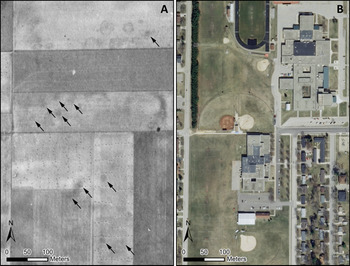
At one site in our study, the Prairie du Sac Cornfields site (47Sk95) in Prairie du Sac on the Wisconsin River, we discovered what are possibly the remains of previously unreported house basins. These features, of which there are at least 10, appear as dark circular stains, the most defined of which measure approximately 12–15 m in diameter (Figure 10a). Remains of semi-subterranean houses typically appear as dark spots in aerial imagery because they tend to retain water. These likely house basins resemble similar features identified in historical aerial photographs in Illinois at 11Wi2739 measuring 10 m in diameter (McLeester et al. Reference McLeester, Casana, Schurr, Chad Hill and Wheeler2018), as well as the remains of semi-subterranean houses and earth lodges commonly found at sites further west (e.g., Johnson et al. Reference Johnson, Ahler, Hass and Bonani2007).
Dark circular stains interpreted as house basins at the Prairie du Sac Cornfields site (47Sk95) in the (A) 1937 imagery and (B) modern 2016 aerial imagery. Arrows point to identified basins. Sources: (A) Wisconsin Historic Aerial Imagery Viewer, (B) Wisconsin Department of Natural Resources. (Color online)

The types or sizes of houses common in Wisconsin during the Late Woodland period remain poorly understood because few archaeological examples exist. Overall, housing structures in Wisconsin vary significantly, with multiple contemporaneous types (McKusick Reference McKusick1973; Radin Reference Radin1923). Known examples of Late Woodland houses include surface structures such as wigwams and longhouses (Moss Reference Moss2010; O'Gorman Reference O'Gorman2010) as well as semi-subterranean house basins (Rosebrough Reference Rosebrough2010). Sizes of all types of housing structures vary considerably, with housing areas ranging from 5.2 m2 to 380.9 m2 during the terminal precontact period (ca. AD 1400–1675; Hollinger Reference Hollinger and Green1995). The probable house basins observed in this study have areas ranging near the mean housing area for this period, from approximately 113 m2 to 177 m2, although we cannot be certain of either the dates for the house basins or their association with the recorded agricultural fields.
Although the spots evident in historical 1930s imagery of 47Sk95 are somewhat larger than subterranean house types typically identified in Wisconsin, their actual size is difficult to measure accurately in imagery of this resolution, and they may also appear exaggerated due to erosion or other taphonomic processes. Despite the extensive development in this area, ground-checking of these potential house basins may be possible given that several of the features are located today within recreational fields (Figure 10b).
Discussion
Results have demonstrated the significant fact that in at least some areas of Wisconsin, precolumbian and early historic Indigenous agricultural fields, as well as other cultural features—including earthworks, effigy mounds, and house basins—are resolvable in 1930s aerial imagery. Although these features are often subtle and, in many instances, difficult to distinguish from 1930s landscape elements, a careful, contextual analysis such as the one we have undertaken here can be successful in documenting them, contributing to an improved understanding of known sites and the discovery of undocumented archaeological sites and landscape features. In particular, the examples of preserved Indigenous field systems we have located in this study should encourage scholars to utilize historical aerial imagery for this and other kinds of landscape-scale analyses. Moreover, with over 90% of previously documented agricultural fields destroyed or obscured by modern land use, our study further demonstrates the uniquely powerful role that analyses of historical aerial imagery play in efforts to reconstruct past agricultural landscapes.
Findings of extant field systems and other cultural features underscore some of the key taphonomic landscape processes driving the survival and visibility of archaeological features in the region. The documentation of agricultural features by archaeologists during the late nineteenth and early twentieth centuries show that they were, predictably, concentrated in the richest farmland (Gartner Reference Gartner2003:34), but severe impacts from agricultural practices instituted in the region since the late 1800s have resulted in the widespread destruction of Indigenous fields. Surviving examples of archaeological features appear to be mostly located on hillsides, below forests, and in agriculturally marginal lands. Combined with natural geomorphic processes including floodplain aggradation and erosion, the parts of the landscape that would have been most attractive to past Indigenous farming communities are essentially devoid of evidence for pre-European agriculture—a common issue in dynamic archaeological landscapes like this one (e.g., Wilkinson Reference Wilkinson2003:7–10). This effective inversion of the archaeological record, in which features are best preserved in the areas that were least utilized by people in the past, should signal a cautionary note for how we interpret the extent, intensity, and locations of earlier farming systems.
The fragmentary preservation of early agricultural fields and their spatial distribution across the landscape advances our understanding of archaeological Indigenous agricultural systems. Agricultural features that we have identified in 1930s imagery are often a considerable distance (>1 km) from the archaeological sites where they were originally noted; they overlap with sites where they were not recorded; or they are located outside of site areas in existing state records. The widespread distribution of these features suggests that Indigenous field systems may have been considerably larger than is often assumed. For example, nineteenth-century Euro-American historical sources document Indigenous field sizes of up to 121 ha, yet Black Hawk—a Sauk leader from northern Illinois—states in his 1833 autobiography that 323 ha (800 acres) were under cultivation at his village (Hawk Reference Hawk2008 [1833]). The much larger field size recounted by Black Hawk accords well with our data, which indicate that past Indigenous agricultural landscapes may have been far larger and more widespread than is currently acknowledged by archaeologists. At the same time, the highly fragmentary preservation of agricultural features in the modern landscape, combined with the complex constellation of variables including land cover, soil moisture, and lighting conditions that impact the visibility of features in aerial imagery would problematize any quantitative assessment of the size and distribution of such features. However, a more comprehensive analysis of additional imagery sources over larger areas, combined with a predictive modeling approach, could begin to provide a better assessment of the magnitude of Indigenous field systems in the region.
The extensive nature of the field systems and other cultural features we have documented in this study, within and beyond existing site boundaries, works to underscore the limits of the archaeological “site” as an operational concept (Binford Reference Binford, Rossignol and Wandsnider1992; Dunnel Reference Dunnell and Wandsnider1992; Howey and Brouwer Burg Reference Howey and Burg2017; McCoy Reference McCoy2020). Although a long history of scholarship has problematized the archaeological “site” and the intellectual baggage with which it comes, sites remain the primary recording and documentation system used in both academic and cultural resource management archaeology, largely because they offer a simple way to represent areas in the landscape that are of particular interest or significance to archaeologists. The remnant cultural features documented in this study—which are often subtle, potentially devoid of artifacts, and extending over enormous areas of the landscape—are among the most difficult cultural features to fit into a site-based model of the archaeological record. Within the counties we have studied, there are over 6,000 archaeological sites previously recorded, a testament to how this region has been extensively utilized for millennia, and yet relict fields detected are rarely within these existing site boundaries. Instead, agricultural fields, effigy mounds, and other cultural features are situated near, adjacent to, and on top of one another. Consequently, rather than understanding them as discrete cultural elements decoupled from the broader landscape, they represent aspects of a shaped, encountered, and experienced landscape.
Conclusions
This article demonstrates the value of historical aerial imagery to detect archaeological landscape features in the upper Midwest, an approach that remains an underutilized tool in North American archaeology despite its unique ability to reveal sites and features that have been obscured or destroyed by modern land use practices. Here, we successfully illustrate that archaeological agricultural fields, effigy mounds, earthworks, and house basins can be detected in historical photography. In several instances, we located previously unknown features—including possible house basins, ridged fields, and earthworks—further demonstrating the potential of this resource to advance understandings of archaeological landscapes within the United States as well as to identify spaces for future archaeological excavation projects. Specific to this study, results reveal the morphological diversity of precolumbian and historic Indigenous agricultural fields, capturing both linear and curved arrangements of hills, ridges, and combinations of hills and ridges. Although the absolute size of agricultural fields remains difficult to determine, results nonetheless suggest that fields systems had a range of sizes, including some that were far more expansive than typically recognized in archaeological literatures (but see Hawk Reference Hawk2008 [1833]). Because agricultural features are challenging to identify in historical imagery and easily confused with early twentieth-century landscape features, future scholars looking to undertake similar projects are provided with examples of both positive features and 1930s land use that resembles them to help springboard their efforts.
This study also highlights the challenges and limitations of working within a site-based model by documenting vast, interconnected cultural landscapes as well as showcasing new opportunities to discover them. Findings presented in this article articulate how agricultural spaces are deeply interwoven with other cultural features, such that it is impossible to view any observed cultural features as discreet. Our methods additionally reaffirm the movement away from the site concept in archaeological research, given that remnants of sites and additional features are often encountered outside of recorded site boundaries.
Finally, it is important to note that although historical aerial imagery like that employed in this and other similar studies is now well demonstrated to be a critical resource for research in archaeology as well as other disciplines—including ecology, geomorphology, and urban planning—this imagery remains difficult for researchers to access. Although the state of Wisconsin has made historical aerial imagery datasets widely available, similar archives exist across the rest of the country and beyond. Aerial photographic surveys were conducted by the U.S. Department of Agriculture and other federal and state agencies beginning in the 1920s, and these precious images are now curated by a variety of public and private institutions, but there is generally little effort to digitize analog film or to make these resources available to researchers. Results in this article help to demonstrate some of the many ways in which historical aerial photographs constitute unique resources for research across a range of disciplines, and we hope to encourage more investment in improving the preservation of and access to these public datasets.
Acknowledgments
The research undertaken for this article was possible because of the expansive data made available by the state of Wisconsin, especially through the Wisconsin Historical Society and State Cartographer's Office, and we owe tremendous gratitude to Amy Wyatt, Amy Rosebrough, and Felipe Avila. The Wisconsin Archeological Society generously granted permissions to reprint images originally published in The Wisconsin Archeologist, and we thank Seth Schneider for facilitating that process. Many thanks to Carolin Ferwerda of the Spatial Archaeometry Lab (SPARCL) at Dartmouth College for her assistance with the images during COVID-19 quarantine. Thanks also to Austin Chad Hill for his help with processing imagery and preparing map data, as well as to Pete Geraci for his assistance procuring related articles and site data. We are grateful to Estefanía Vidal Montero for translating our abstract. Funding for this project was provided by a grant from the National Science Foundation's Archaeometry Program (#182210), supporting the Spatial Archaeometry Research Collaborations (SPARC) initiative.
Data Availability Statement
The site locations and shapefiles used in this article are available from the Wisconsin Historical Society. The images used were downloaded from the Wisconsin Historical Aerial Imagery Finder, a public resource provided by the State Cartographer's Office. Specific images or other data from this article are available upon request from the authors.