The landforms, deposits and palaeoenvironmental records of the Quaternary Period are a highly visible part of Scotland's varied landscapes and geoheritage. In the light of the advances in Quaternary research reviewed in this Special Issue of the Earth and Environmental Science Transactions of the Royal Society of Edinburgh, it is timely to re-evaluate which sites merit conservation to record and represent the latest progress in the science and the key evidence to understand long-term global environmental changes and landscape evolution, past and present, both for scientific and educational values and for wider geoheritage values (Crofts & Gordon Reference Crofts, Gordon, Worboys, Lockwood, Kothari, Feary and Pulsford2015). The legacy of the Quaternary is an integral part of Scotland's natural heritage but is at risk from inappropriate land use, development and other human impacts, as well as climate change. The need for Quaternary geoconservation in general reflects the value and vulnerability of particular features and sites (Burek Reference Burek2012; Brown et al. Reference Brown, Gordon, Burek, Campbell, Bridgland, Catt and Candy2014; Gordon Reference Gordon2015), as well as the relevance of understanding the past for nature conservation, habitat restoration and environmental management (Vegas-Vilarrúbia et al. Reference Vegas-Vilarrúbia, Rull, Montoya and Safont2011; Gray et al. Reference Gray2013; Dietl et al. Reference Dietl, Kidwell, Brenner, Burney, Flessa, Jackson and Koch2015; McCarroll et al. Reference McCarroll, Chambers, Webb and Thom2017). At the same time, there are pressing challenges to promote better understanding of the value and benefits of geoconservation for society, to mainstream geoconservation in the wider nature conservation agenda and to contribute toward natural solutions to global problems (Gordon et al. Reference Gordon, Crofts, Díaz-Martínez and Woo2018a). Outreach that enhances public understanding of the science, supports geoparks and geotourism and promotes awareness of the many ecosystem services and benefits for people and the environment is now beginning to reflect this broader outlook (Prosser et al. Reference Prosser, Bridgland, Brown and Larwood2011, Reference Prosser, Brown, Larwood and Bridgland2013; Gordon et al. Reference Gordon2012, Reference Gordon, Crofts, Díaz-Martínez and Woo2018b; Gray Reference Gray2013; Crofts & Gordon Reference Crofts, Gordon, Worboys, Lockwood, Kothari, Feary and Pulsford2015). Nevertheless, it remains that geoconservation is fundamentally predicated on the safeguard of protected areas based on site inventory and assessment that are underpinned by up-to-date scientific evidence (Brilha Reference Brilha, Reynard and Brilha2018a).
We outline here the value of geoheritage and geoconservation and examine the historical development of geosite conservation in Scotland within the context of geoconservation in Great Britain and internationally. We focus on the Great Britain Geological Conservation Review (GCR) and the developments in Quaternary science and geomorphology in Scotland that have taken place since the publication of the benchmark GCR volumes on the Quaternary of Scotland (Gordon & Sutherland Reference Gordon and Sutherland1993a), Fluvial Geomorphology (Werritty & McEwen Reference Werritty, McEwen and Gregory1997), Karst and Caves (Waltham et al. Reference Waltham, Simms, Farrant and Goldie1997), Coastal Geomorphology (May & Hansom Reference May and Hansom2003) and Mass Movements (Cooper Reference Cooper2007). The GCR process provides the scientific underpinning for geosite conservation in Britain. It is not a static process and we take stock of the scientific framework and site coverage for the respective GCR volumes in the light of the scientific advances and investigations of new sites reviewed in the other contributions to this special issue. Finally, we consider how geoheritage protected areas might evolve in line with the changing nature conservation agenda.
1. The development of geoconservation in Scotland
Geoconservation is the practice of conserving, enhancing and promoting awareness of those elements of geodiversity that have particular value (Prosser Reference Prosser2013a; Crofts & Gordon Reference Crofts, Gordon, Worboys, Lockwood, Kothari, Feary and Pulsford2015). Historically, geoconservation in Scotland, and more widely in Britain, progressed in an ad hoc manner through the protection of a few emblematic sites during the 19th and early 20th Centuries in response to specific threats (Thomas & Warren Reference Thomas, Warren, Burek and Prosser2008; Larwood Reference Larwood and Hose2016; Brazier et al. Reference Brazier, Bruneau, Gordon and Rennie2017; Gordon et al. Reference Gordon, Crofts, Díaz-Martínez and Woo2018b). The development of modern geoconservation in Britain effectively began in the 1940s (Burek & Prosser Reference Burek, Prosser, Burek and Prosser2008; Prosser Reference Prosser2013b), when the National Parks and Access to the Countryside Act (1949) first established a statutory basis for the systematic protection of biological and geological features of scientific interest within nature reserves and Sites of Special Scientific Interest (SSSIs). Nature reserves initially provided a higher level of protection than SSSIs, but subsequently the Wildlife and Countryside Act (1981) and the Nature Conservation (Scotland) Act 2004 have aimed to strengthen the conservation management of SSSIs.
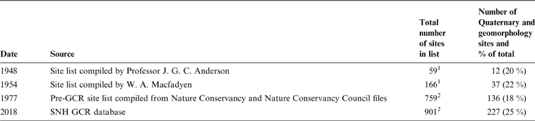
The groundwork for the designation of nature reserves was prepared by the Society for the Promotion of Nature Reserves in the early 1940s through the Nature Reserves Investigation Committee (Sheail Reference Sheail1998). The latter included a geological sub-committee that consulted widely to produce a list of 390 localities in England and Wales recommended for protection as geological reserves (Anon 1945). In 1948, Professor J. G. C. Anderson of the Geological Survey of Scotland compiled at short notice a list of 59 sites for Scotland; 12 were proposed primarily for their geomorphological or Quaternary features (Table 1) (see supplementary Table 1 available at https://doi.org/10.1017/S1755691019000069 for details). This list provided the starting point for systematic protection of geoheritage sites in Scotland (Gordon Reference Gordon, Stevens, Gordon, Green and Macklin1994). It was circulated for comment by the then Nature Conservancy (NC) geologist, W. A. Macfadyen, and by 1953 had been extended to 96 sites. The Geological Survey of Scotland added a further 65 sites, and in 1954 the officially recommended list of geosites for Scotland comprised 166 sites. Of these, 37 were included specifically for geomorphology and Quaternary features of interest and formed the basis for SSSI designation (Table 1) (see supplementary Table 2 for details). Sites were identified on the basis of their value, as assessed by geological experts, for study and research or preserving features of special interest, as set out in the 1949 Act. Various regional site assessment surveys were instigated by the NC and its successor body formed in 1973, the Nature Conservancy Council (NCC), as part of a rolling programme to revise the site coverage. By the mid-1970s the number of geomorphology and Quaternary sites in Scotland had reached 136 (Table 1) (see supplementary Table 3 for details). These surveys included various site assessment criteria and expert input but limited comparative site evaluation (Gordon Reference Gordon, Stevens, Gordon, Green and Macklin1994). Importantly, however, they did not address the need for systematic national overview and evaluation based on standard site assessment criteria. Eventually in 1977, as a complementary process to the Nature Conservation Review (Ratcliffe Reference Ratcliffe1977), the Geological Conservation Review (GCR) was set up by the NCC to provide a comprehensive and systematic assessment of all key sites representing the scientific interests of the geology and geomorphology of Great Britain (Ellis Reference Ellis, Burek and Prosser2008, Reference Ellis2011). The main site audit phase of the GCR was largely completed by the early 1990s, with publication to follow, although it was recognised that the site lists would require updating as part of an ongoing process (Ellis Reference Ellis, Burek and Prosser2008). Following the devolution of responsibility for environmental matters to Scotland and Wales in 1991, the Joint Nature Conservancy Committee (JNCC) initially took over the management of the GCR throughout Great Britain and the publication of the results, but more recently this has been overseen by a group of geoconservation representatives from the country conservation agencies in England, Scotland and Wales.
Summary of the numbers of all Quaternary and geomorphology sites in Scotland proposed at different dates for conservation (includes glacial geomorphology, coastal geomorphology, fluvial geomorphology, mass movements, caves and karst sites).

1 Includes composite sites with multiple interests.
2 Single Interest Localities only (some sites may be listed more than once under different topic headings).
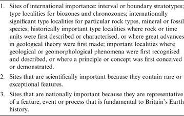
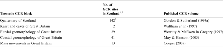
GCR sites are selected for their scientific interest alone, based on specific criteria (Table 2) and through a process of expert review. Consequently, they must make a special contribution to the understanding and appreciation of Britain's geology and geomorphology. Each site is at least of national importance, many are internationally important and together the site network comprehensively represents the geology and geomorphology of Great Britain (Ellis Reference Ellis2011). Sites are assessed under seven geoscience categories: stratigraphy, palaeontology, Quaternary geology, geomorphology, igneous petrology, structural and metamorphic geology, and mineralogy. For practical purposes, these categories are subdivided into thematic subject ‘blocks' according to stratigraphy, type of interest, geographical area or different geological and geomorphological processes (Ellis Reference Ellis2011). A common theme is that most sites form part of a network of related sites that collectively represent a particular time period, event or set of geomorphological processes and landforms (e.g., the Quaternary of Scotland, fluvial geomorphology, coastal geomorphology, mass movements, and karst and caves). The total number of GCR sites in Great Britain is ∼3000, with 901 in Scotland (http://www.jncc.defra.gov.uk/page-4171). Of these, 227 have been selected for Quaternary and geomorphology interests in Scotland (Table 3) (See supplementary Table 4 for details). The GCR provides the scientific evidence for SSSI designation, and most GCR sites have been wholly or partially designated as SSSIs. A fundamental premise of the GCR is that site assessment is not a once-and-for-all exercise, but is an ongoing process so that new sites can be added as they are discovered, or their significance becomes apparent in the light of new research. A corollary is that sites can be removed from the GCR listing if better sites are discovered or, as also occurs with SSSIs, if they are significantly damaged or destroyed. Similar audits have been conducted, or are in progress, in many other countries in Europe, recognising the value of geoheritage and the widespread threats (Wimbledon & Smith-Meyer Reference Wimbledon and Smith-Meyer2012).
GCR Site selection guidelines (from Ellis et al. Reference Ellis, Bowen, Campbell, Knill, McKirdy, Prosser, Vincent and Wilson1996; Ellis Reference Ellis2011).

Quaternary and geomorphology blocks of the GCR in Scotland.

1 The number of GCR sites in each block is from the current (2018) SNH GCR database and may be different to the number of GCR sites listed in the relevant published volume or in the JNCC database (www.jncc.defra.gov.uk/page-4171). This is because the GCR site lists are continually reviewed, and sites are added and deleted, whereas the published volumes represent the site lists at the time of publication.
2 A list of the sites is included in supplementary Table 4.
3 Includes two Pleistocene Vertebrate sites.
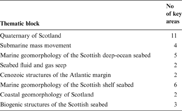
The GCR considered only terrestrial sites. However, improved mapping of seabed features using sonar, seismic and multibeam swath bathymetry methods has enabled the acquisition of a much more detailed body of information on marine geology and geomorphology than previously available (Phillips et al. Reference Phillips, Hodgson and Emery2017). At the same time, there has been growing recognition of the need for conservation of marine habitats and species through national and international measures and a better understanding of the links between geodiversity and biodiversity in the marine environment. Using criteria and a methodology that followed the principles of the terrestrial GCR enabled a first-level assessment of sea-floor features and the prioritisation of 35 key areas in eight thematic blocks principally for geomorphology and Quaternary interests (Table 4) (Brooks et al. Reference Brooks, Kenyon, Leslie, Long and Gordon2013; Gordon et al. Reference Gordon, Brooks, Chaniotis, James, Kenyon, Leslie, Long and Rennie2016). These key areas provided supporting evidence for the identification and selection of a suite of Nature Conservation Marine Protected Areas (MPAs) in Scotland's seas containing important marine natural features (Gordon et al. Reference Gordon, Brooks, Chaniotis, James, Kenyon, Leslie, Long and Rennie2016).
Key geodiversity areas in Scottish waters categorised by thematic block (from Gordon et al. Reference Gordon, Brooks, Chaniotis, James, Kenyon, Leslie, Long and Rennie2016). A list of the key areas is included within supplementary Table 5.

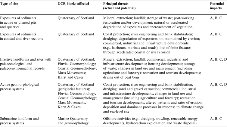
2. Threats to sites
Site protection and conservation form the core of geoconservation activities. Quaternary and geomorphology sites are vulnerable to a wide range of human-driven threats including urbanisation, commercial, industrial and infrastructure developments, mineral extraction, land use changes, coastal defences and loss of moveable geoheritage (e.g., fossil and mineral specimens) (Table 5) (Crofts & Gordon Reference Crofts, Gordon, Worboys, Lockwood, Kothari, Feary and Pulsford2015; Prosser et al. Reference Prosser, Díaz-Martínez, Larwood, Reynard and Brilha2018). Accelerating climate change represents an additional threat, including rising sea level. Qualitative risk analysis indicates that active soft-sediment coastal and fluvial features, coastal and river Quaternary sediment exposures and landforms, active periglacial features and sites with palaeoenvironmental records are most vulnerable to climate-related changes and human responses (e.g., installation of coastal defences) (Prosser et al. Reference Prosser, Burek, Evans, Gordon, Kirkbride, Rennie and Walmsley2010; Brazier et al. Reference Brazier, Bruneau, Gordon and Rennie2012; Wignall et al. Reference Wignall, Gordon, Brazier, MacFadyen and Everett2018). The principal impacts arising from these threats are:
• partial or complete destruction of landforms and exposures of sediments;
• fragmentation of site integrity and loss of relationships between features, particularly where the interest lies in assemblages of landforms;
• loss of access to landforms and exposures;
• loss of visibility, naturalness or aesthetic value;
• disruption or deactivation of geomorphological processes.
Principal threats affecting Quaternary and geomorphology sites in Scotland. Potential impacts: A. Development or activities which can obscure or mask the surface and stratigraphic features of interest, restrict access or inhibit erosion and allow exposures to become degraded. B. Development or activities which can cause localised disruption or destruction of part of the landform assemblage or stratigraphic record, including fragmentation of site integrity and loss of relationships between features, or disruption of natural processes, including stabilisation of dynamic landforms. C. Development or activities which can either disrupt or destroy the whole or most of the landform assemblage in terms of surface form or stratigraphic record or inhibit natural processes in dynamic systems. D. Development or activities which can cause aesthetic deterioration where the site or feature has landscape or cultural value.

Some small sites (e.g., exposures in disused pits) may be managed as discrete entities, but many geomorphological features occur as assemblages of inter-related landforms or complex landform-process systems (Kiernan Reference Kiernan1996; Reynard Reference Reynard, Reynard, Coratza and Regolini-Bissig2009), so that impacts of fragmentation and loss of integrity may be significant. Another important consideration is that developments beyond the protected area boundary may impact on the protected features (e.g., coast defence structures in one area may accelerate erosion elsewhere).
Inactive landforms and finite deposits (e.g., interglacial soils) are particularly susceptible to disturbance from human activities. If damaged or destroyed, they cannot reform or be re-created. Some active features (e.g., river bars and sand dunes) are potentially more robust as they may be able to re-form after limited disturbance provided that the natural processes and sediment supplies are maintained (Kirkbride & Gordon Reference Kirkbride and Gordon2010).
3. The GCR and the scientific importance of Quaternary deposits and landforms in Scotland
Because Quaternary deposits and landforms cover the entire surface of Britain, their evaluation for the GCR was framed around a series of blocks that comprise networks of sites representing the major regional variations in Quaternary stratigraphy, events, environments and processes. As for other GCR blocks, site selection for the Quaternary of Scotland GCR block followed the criteria in Table 2 and was informed by guidelines that included uniqueness, presence of classic examples, representativeness, providing understanding of present environments, historical importance and research potential and educational value (Gordon & Sutherland Reference Gordon, Sutherland, Gordon and Sutherland1993b). For other GCR volumes that include Quaternary geomorphology interests (Table 3), sites were selected according to similar principles with networks appropriate to the particular subject themes (e.g., coastal cliffs, beaches, spits and barriers, and saltmarshes for coastal geomorphology). The site networks were compiled on a Great Britain-wide basis but include the particular forms and processes in Scotland; for example, 71 % by area of coastal dunes lie in Scotland.
Some sites are internationally important because of their significance in the history of the science or the widespread recognition of their textbook features (e.g., the Cairngorms and Glen Roy); others demonstrate internationally exceptional features such as the machair dune systems of the Western and Northern Isles. Some are extremely rare in representing the relatively few records of pre-Late Devensian stratigraphy. Sites are not selected in isolation but form part of networks of related interests that together represent aspects of the geomorphology, landscape evolution or environmental change during the Quaternary or the essential features of a particular phenomenon or event and the factors determining its major variations where these vary regionally (e.g., the networks of sites representing fluvial and coastal geomorphology, postglacial sea-level changes or Lateglacial environmental changes). Usually they will be the best studied, best preserved or have the most complete records in their area and together the site network will represent the range of features, their variations in relation to geology, climate, soils or other influencing factors (e.g., the range of mass movement features developed on different lithologies). Some sites are also type or classic localities for particular features (e.g., sites at the south end of Loch Lomond in the type area for the Loch Lomond Readvance, and Islay and Jura for shore platforms). Despite nearly 180 years of study, many sites still pose fundamental research questions concerning climate change and landscape evolution (e.g., Glen Roy; Palmer & Lowe Reference Palmer and Lowe2017; Palmer et al. Reference Palmer, Cornish, Lowe, Boston, Lukas, Cornish, Lowe, Palmer, Carter-Champion, McLeod, Ramirez-Rojas, Timms and Sissons2018; Peacock Reference Peacock, Boston, Lukas, Cornish, Lowe, Palmer, Carter-Champion, McLeod, Ramirez-Rojas, Timms and Sissons2018), while others continue to provide new insights into the pattern and timing of critical events of global significance (Bromley et al. Reference Bromley, Putnam, Borns, Lowell, Sandford and Barrell2018). Taken together, sites selected should represent the highlights of British geology and geomorphology but in a minimalist way avoiding duplication of features of interest (Ellis Reference Ellis2011).
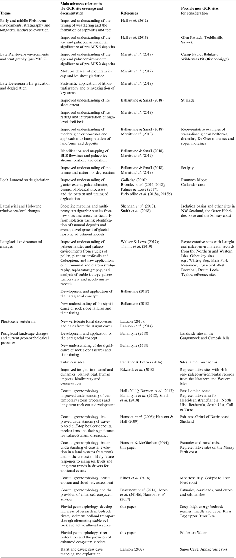
Scientific importance is the prime consideration for GCR site selection and reflects the principal themes in Scottish Quaternary studies (Table 6). These may be summarised under five main headings: (1) long-term landscape evolution; (2) Quaternary stratigraphy, glacial landforms and deposits, and the history of glaciation; (3) Lateglacial and Holocene climate and environmental history; (4) relative sea-level (RSL) changes; and (5) postglacial geomorphological processes and landforms. The landform, sedimentary and palaeoenvironmental records in each of these contexts have exceptional value of both national and international significance.
Summary of recent advances in Quaternary studies and geomorphology that have a bearing on the GCR site coverage and documentation. References are primarily given to papers in this volume, from where further sources are available.

3.1. Long-term landscape evolution
The present landscapes of Scotland have evolved over many millions of years and bear the cumulative imprint of glacial and non-glacial processes throughout the Pleistocene and earlier (Hall Reference Hall1991; Hall & Bishop Reference Hall, Bishop, Doré, Cartwright, Stoker, Turner and White2002). Hall et al. (Reference Hall, Merritt, Connell and Hubbard2018) note that recent work has largely focused on the Late Pleistocene part of the Quaternary, reflecting the more limited preservation of evidence and the difficulties of dating older landforms and deposits. However, new methods of dating, advances in landscape modelling and availability of offshore evidence for the timing and duration of glacial and non-glacial periods are leading to renewed interest in longer-term landscape evolution. Improved understanding of the timing of weathering and the formation of saprolites and tors has demonstrated the dynamic nature of landform and landscape evolution throughout the Pleistocene and the role of non-glacial and glacial processes (Hall Reference Hall2005; Phillips et al. Reference Phillips, Hall, Mottram, Fifield and Sugden2006; Hall et al. Reference Hall, Merritt, Connell and Hubbard2018). Multiple phases of mountain ice cap and ice sheet glaciation with variable thermal conditions have produced cumulatively variable impacts that range from intensive to limited glacial erosion. Because of the diversity of features, the landforms and deposits of Scotland have an important part to play in understanding long-term landscape evolution through the new approaches outlined by Hall et al. (Reference Hall, Merritt, Connell and Hubbard2018) and developing and validating models for rates of landscape evolution under glacial and non-glacial processes and different climate and tectonic regimes.
3.2. Quaternary stratigraphy, glacial landforms and deposits, and the history of glaciation
The geomorphological and sedimentary records both on land and offshore associated with the last British–Irish Ice Sheet (BIIS) and its predecessors are important for understanding the history and dynamics of marine-based ice sheets and particularly their responses in terms of growth and decay to climate change, ocean circulation and other forcing factors such as sea-level change. The BIIS was largely marine-based and is considered to have been particularly sensitive to climate changes (Hibbert et al. Reference Hibbert, Austin, Leng and Gatliffe2010; Thierens et al. Reference Thierens, Pirlet, Colin, Latruwe, Vanhaecke, Lee, Stuut, Titschack, Huvenne, Dorschel, Wheeler and Henriet2012). Much of the evidence is offshore in the form of seabed geomorphology and dateable sedimentary records (Phillips et al. Reference Phillips, Hodgson and Emery2017; Callard et al. Reference Callard, Ó Cofaigh, Benetti, Chiverrell, Van Landeghem, Saher, Gales, Small, Clark, Livingstone, Fabel and Moreton2018). The importance of this evidence is underlined by Sejrup et al. (Reference Sejrup, Nygård, Hall and Haflidason2009), who asserted that the northern North Sea region ‘most likely possesses the best dated marine-based Late Pleistocene ice sheet in the world' (p. 377). A combination of availability of offshore data, advances in mapping and dating of both onshore and offshore landforms and sediments, together with whole ice-sheet modelling, has demonstrated a highly dynamic ice sheet (Bradwell et al. Reference Bradwell, Stoker, Golledge, Wilson, Merritt, Long, Everest, Hestvik, Stevenson, Hubbard, Finlayson and Mathers2008; Hubbard et al. Reference Hubbard, Bradwell, Golledge, Hall, Patton, Sugden, Cooper and Stoker2009; Clark et al. Reference Clark, Hughes, Greenwood, Jordan and Sejrup2012, Reference Clark, Ely, Greenwood, Hughes, Meehan, Barr, Bateman, Bradwell, Doole, Evans, Jordan, Monteys, Pellicer and Sheehy2018a; Bradwell & Stoker Reference Bradwell and Stoker2015; Ballantyne & Small Reference Ballantyne and Small2018; Merritt et al. Reference Merritt, Hall, Gordon and Connell2019). Progress in understanding the pattern of deglaciation of the last BIIS and its responses to climate factors and sea-level changes has allowed insights into the coupling of ice-sheet dynamics, ocean processes, climate, the rheology of the upper mantle, glacio-isostatic adjustment and RSL change (Milne et al. Reference Milne, Shennan, Youngs, Waugh, Teferle, Bingley, Bassett, Cuthbert-Brown and Bradley2006; Bradley et al. Reference Bradley, Milne, Shennan and Edwards2011; Callard et al. Reference Callard, Ó Cofaigh, Benetti, Chiverrell, Van Landeghem, Saher, Gales, Small, Clark, Livingstone, Fabel and Moreton2018; Smith et al. Reference Smith, Barlow, Bradley, Firth, Hall, Jordan and Long2018), while studies of the landforms and deposits of the west coast fjords have elucidated the later stages of deglaciation of the BIIS and the subsequent re-expansion of glaciers in the N and W Highlands during the Loch Lomond (Younger Dryas) Stade (Stoker et al. Reference Stoker, Bradwell, Howe, Wilkinson and McIntyre2009; Howe et al. Reference Howe, Anderton, Arosio, Dove, Bradwell, Crump, Cooper and Cocuccio2015a; Small et al. Reference Small, Rinterknecht, Austin, Bates, Benn, Scourse, Bourlès, Team and Hibbert2016).
Because of their length and continuity, the analysis of cores from the offshore sedimentary records, notably from the Barra Fan, Rosemary Bank and Rockall Trough, has provided insights into several key aspects of Quaternary climate change, ocean circulation and ice-sheet fluctuations over different timescales. For example, they have revealed repeated glaciations extending to the shelf edge (Scourse et al. Reference Scourse, Haapaniemi, Colmenero-Hidalgo, Peck, Hall, Austin, Knutz and Zahn2009; Hibbert et al. Reference Hibbert, Austin, Leng and Gatliffe2010), with complex spatial and temporal variations in the fluctuations of the last BIIS at millennial timescales associated with latitudinal variations in the North Atlantic Polar Front, and regional-scale changes in palaeoceanography and climate variations at the millennial scale (see references in Gordon et al. Reference Gordon, Brooks, Chaniotis, James, Kenyon, Leslie, Long and Rennie2016). Similarly, the thick sedimentary archives of the North Sea basin provide an unrivalled record of multiple glacial and interglacial episodes during the Quaternary (Phillips et al. Reference Phillips, Hodgson and Emery2017; Rea et al. Reference Rea, Newton, Lamb, Harding, Bigg, Rose, Spagnolo, Huuse, Cater, Archer, Buckley, Halliyeva, Huuse, Cornwell, Brocklehurst and Howell2018). In comparison, the onshore sedimentary record is fragmentary since the last Scottish Ice Sheet largely removed or reworked earlier deposits. Hence the small number of pre-Marine Isotope Stage (MIS) 2 terrestrial sites have exceptional scientific and conservation importance. Few new such sites have come to light in the last 25 years, but improvements in dating and stratigraphy have refined, and in some cases significantly revised, the interpretations of the existing sites (Hall et al. Reference Hall, Merritt, Connell and Hubbard2018; Merritt et al. Reference Merritt, Hall, Gordon and Connell2019).
A feature of the BIIS was the presence of fast-moving ice streams mainly revealed by offshore bedform assemblages (Stoker & Bradwell Reference Stoker and Bradwell2005; Bradwell et al. Reference Bradwell, Stoker and Larter2007; Dove et al. Reference Dove, Arosio, Finlayson, Bradwell and Howe2015). These palaeo-ice streams on the Scottish shelf have the potential to help better understand the dynamics of contemporary ice sheets in Greenland and Antarctica (Stoker & Bradwell Reference Stoker and Bradwell2005; Bradwell et al. Reference Bradwell, Stoker, Golledge, Wilson, Merritt, Long, Everest, Hestvik, Stevenson, Hubbard, Finlayson and Mathers2008; Callard et al. Reference Callard, Ó Cofaigh, Benetti, Chiverrell, Van Landeghem, Saher, Gales, Small, Clark, Livingstone, Fabel and Moreton2018). In particular, the dynamics of the BIIS may offer insights into the future stability of the marine-based West Antarctic Ice Sheet, whose ice streams are of current concern under conditions of global warming, sea-level rise and possible changes in ocean circulation (Lenton et al. Reference Lenton, Held, Kriegler, Hall, Lucht, Rahmstorf and Schellnhuber2008; Clark et al. Reference Clark, Hughes, Greenwood, Jordan and Sejrup2012; Ó Cofaigh Reference Ó Cofaigh2012).
As in many parts of the world, the landforms produced by the BIIS allow access to the beds of former ice sheets, enabling interpretation of former ice flow conditions and providing constraints and boundary conditions for ice sheet models (Ó Cofaigh & Stokes Reference Ó Cofaigh and Stokes2008; Stokes Reference Stokes2018; Clark et al. Reference Clark, Ely, Spagnolo, Hahn, Hughes and Stokes2018b). Although the terrestrial evidence represents only a small, and often discontinuous, part of the ice-sheet footprint, it is relatively accessible (Merritt et al. Reference Merritt, Hall, Gordon and Connell2019). The formation and evolution of subglacial bedforms, such as drumlins and megascale glacial lineations (MSGLs), underpin the understanding of glacier processes and provide key boundary conditions for modelling past, present and future ice sheet evolution and their interplay with sea level (Barchyn et al. Reference Barchyn, Dowling, Stokes and Hugenholtz2016). This also applies to hard bedrock forms for the reconstruction of palaeo-ice streams and their controlling factors (Krabbendam et al. Reference Krabbendam, Eyles, Putkinen, Bradwell and Arbelaez-Moreno2016). In addition, Evans (Reference Evans2018) has highlighted the importance of tills and associated sediments as archives of subglacial processes.
3.3. Lateglacial and Holocene climate and environmental changes
The Lateglacial interval, between 14.7 and 11.7cal. ka BP, was a period of rapid and substantial environmental change that has been investigated in Scotland through a range of proxy evidence (Walker & Lowe Reference Walker, Lowe and Gordon1997, Reference Walker and Lowe2017). The geomorphological evidence for landscape change is particularly well preserved and includes landforms associated with the re-expansion and retreat of glaciers during the Loch Lomond (Younger Dryas) Stade (Golledge Reference Golledge2010; Bickerdike et al. Reference Bickerdike, Evans, Stokes and Ó Cofaigh2018a) and paraglacial activity (Ballantyne Reference Ballantyne2018).
During the Loch Lomond Stade, a large icefield extended over much of the western Highlands of Scotland from the Loch Lomond basin in the south to Loch Broom in the north, with a range of icefields, plateau, valley and corrie glaciers occupying other upland areas of Scotland (Golledge Reference Golledge2010; Bickerdike et al. Reference Bickerdike, Evans, Stokes and Ó Cofaigh2018a). Detailed geomorphological mapping has enabled palaeoglaciological reconstructions and palaeoclimate inferences from these reconstructions (e.g., Benn & Ballantyne Reference Benn and Ballantyne2005; Golledge et al. Reference Golledge2010; Lukas & Bradwell Reference Lukas and Bradwell2010; Boston et al. Reference Boston, Lukas and Carr2015) and elucidated the responses of different types of glacier to climate forcing (Bickerdike et al. Reference Bickerdike, Ó Cofaigh, Evans and Stokes2018b) and the role of topographic influences (Bickerdike et al. Reference Bickerdike, Ó Cofaigh, Evans and Stokes2018b). Radiocarbon dating on a variety of organic remains, cosmogenic surface exposure dating and varve dating indicate differences in the timing of the maximum extent of different glacier systems during the Stade (Ballantyne Reference Ballantyne2012; Bromley et al. Reference Bromley, Putnam, Rademaker, Lowell, Schaefer, Hall, Winckler, Birkel and Borns2014, Reference Bromley, Putnam, Borns, Lowell, Sandford and Barrell2018; Small & Fabel Reference Small and Fabel2016; Peacock & Rose Reference Peacock and Rose2017). The glacial record of the Loch Lomond Stade is of particular significance for understanding past global climate change and possible implications for modern climate change on account of Scotland's position on the North Atlantic margin of Europe. Changes in the adjacent North Atlantic sea surface temperatures are linked to abrupt climate changes and landscape responses (Bromley et al. Reference Bromley, Putnam, Rademaker, Lowell, Schaefer, Hall, Winckler, Birkel and Borns2014). Among the key landscapes in this context are Glen Roy (Palmer & Lowe Reference Palmer and Lowe2017) and Rannoch Moor (Bromley et al. Reference Bromley, Putnam, Rademaker, Lowell, Schaefer, Hall, Winckler, Birkel and Borns2014, Reference Bromley, Putnam, Borns, Lowell, Sandford and Barrell2018).
Similarly, proxy indicators, including pollen, plant macrofossils, Coleoptera, chironomids, diatoms and the geochemical properties of sediments, obtained mainly from lake sediments, infilled lake sediments and bogs, combined with advances in dating methods, have progressed the reconstruction of climate history, environmental changes, vegetation history and other ecological changes (Walker & Lowe Reference Walker, Lowe and Gordon1997, Reference Walker and Lowe2017). The combination of the different lines of evidence and availability of highly detailed studies of the palaeoenvironmental archives makes Scotland a pivotal area for investigations of terrestrial geomorphological and environmental changes on the Atlantic margin of Europe in response to the rapid climate changes during the Lateglacial (Walker & Lowe Reference Walker and Lowe1997). Comparisons with ice core and marine records offer excellent opportunities for establishing the responses of terrestrial biota, glaciers and geomorphological processes to climate drivers.
Recent palaeoecological research themes in the Holocene have focused on woodland dynamics, blanket peat, human impacts, biodiversity and conservation (Edwards et al. Reference Edwards, Bennett and Davies2018). Rather than generation of routine studies of vegetation history, as in the past, there has been greater critical analysis of existing hypotheses of the roles of climate change and human activities (Edwards et al. Reference Edwards, Bennett and Davies2018). This has led to greater insights into the migration and changing nature of woodland cover and its variations both geographically and with altitude. Human impacts on this woodland cover through agriculture were severe in the S and E from the Neolithic onwards at a time when the growth and spread of blanket peat was a dominant feature of landscape change in the N and W. However, the causes and timing of blanket peat expansion were spatially variable. Today, blanket peat is recognised both for its value as a habitat and as a significant terrestrial carbon sink (Worrall et al. Reference Worrall, Chapman, Holden, Evans, Artz, Smith and Grayson2011; Scottish Natural Heritage 2015). Several investigations, notably from the Northern and Western Isles, highlight the value of linking palaeoecological and archaeological evidence in elucidating human presence and impacts on the landscape both during the Mesolithic and later (Edwards Reference Edwards, McCartan, Schulting, Warren and Woodman2009; Edwards et al. Reference Edwards, Schofield, Whittington, Melton, Finlay, McCartan, Milner and Wickham-Jones2009). In an important new development, palaeoecological evidence is now being used to support biodiversity conservation through helping to inform restoration, availability of past analogues and identification of possible temporary refugia from future climate change (Edwards et al. Reference Edwards, Bennett and Davies2018).
A further development has been the recognition that sediments in the fjords of the W coast also record palaeoenvironmental changes during the Holocene (Howe et al. Reference Howe, Shimmield, Austin and Longva2002; Nørgaard-Pedersen et al. Reference Nørgaard-Pedersen, Austin, Howe and Shimmield2006; Baltzer et al. Reference Baltzer, Bates, Mokeddem, Clet-Pellerin, Walter-Simonnet, Bonnot-Courtois, Austin, Howe, Austin, Forwick and Paetzel2010; Mokeddem et al. Reference Mokeddem, Baltzer, Goubert, Clet-Pellerin, Howe, Austin, Forwick and Paetzel2010), and they form significant marine sinks for organic carbon from terrestrial sources (Burrows et al. Reference Burrows, Kamenos, Hughes, Stahl, Howe and Tet2014; Smeaton et al. Reference Smeaton, Austin, Davies, Baltzer, Howe and Baxter2017).
3.4. Relative sea-level changes
Scotland has a long history of the study of RSL changes during the Late Devensian and Holocene. It has played an important part in the development of key concepts and globally is a test area for glacial isostatic adjustment (GIA) models (Shennan et al. Reference Shennan, Bradley and Edwards2018; Smith et al. Reference Smith, Barlow, Bradley, Firth, Hall, Jordan and Long2018). The acquisition of detailed RSL records based on a range of microfossil proxies from key isolation basins on the coasts of W and NW Scotland (Shennan et al. Reference Shennan, Lambeck, Horton, Innes, Lloyd, McArthur, Purcell and Rutherford2000, Reference Shennan, Hamilton, Hillier and Woodroffe2005, Reference Shennan, Hamilton, Hillier, Hunter, Woodall, Bradley, Milne, Brooks and Bassett2006a) has filled a longstanding geographical gap in a research focus that previously had an eastern Scotland emphasis. Sites near Arisaig, in particular, are notable in providing a near-field record constraining the magnitude of global sea-level rise during Meltwater Pulse 1A (ca.14.6 ka BP), with implications for climate change and global ice sheet melting (Shennan et al. Reference Shennan, Hamilton, Hillier and Woodroffe2005). These studies and those of new sites elsewhere, for example in the carselands and estuarine areas in E Scotland and the Solway Firth (Smith et al. Reference Smith, Hunt, Firth, Jordan, Fretwell, Harman, Murdy, Orford and Burnside2012), and coastal embayments in the Outer Hebrides (Jordan et al. Reference Jordan, Smith, Dawson and Dawson2010), have enabled better understanding of changing environmental conditions, tidal levels and depositional processes and refined considerably the picture of Late Devensian and Holocene RSL changes.
The development of quantitative GIA models (Bradley et al. Reference Bradley, Milne, Shennan and Edwards2011; Kuchar et al. Reference Kuchar, Milne, Hubbard, Patton, Bradley, Shennan and Edwards2012; Stockamp et al. Reference Stockamp, Bishop, Li, Petrie, Hansom and Rennie2016) that can be tested and refined against the detailed studies of RSL changes now available from Scotland and more widely across the British Isles (Shennan et al. Reference Shennan, Bradley, Milne, Brooks, Bassett and Hamilton2006b, Reference Shennan, Bradley and Edwards2018; Smith et al. Reference Smith, Barlow, Bradley, Firth, Hall, Jordan and Long2018) is enabling better understanding of the rheology of the upper mantle, glacio-isostatic adjustment, BIIS ice sheet extent, far-field deglacial chronology and the magnitude and timing of global meltwater discharge, the final deglaciation of the Laurentide ice sheet and melting of the Antarctic Ice Sheet after 7ka BP (Shennan et al. Reference Shennan, Hamilton, Hillier and Woodroffe2005, Reference Shennan, Hamilton, Hillier, Hunter, Woodall, Bradley, Milne, Brooks and Bassett2006a, Reference Shennan, Bradley and Edwards2018). Critically, however, more high-precision records are required from a range of sites, particularly in the N and W, to establish RSL variations during the last ca.2000 years to help inform projections of future changes (Smith et al. Reference Smith, Barlow, Bradley, Firth, Hall, Jordan and Long2018). Rennie & Hansom (Reference Rennie and Hansom2011) used tide-gauge data to argue that GIA is now outpaced by sea-level rise everywhere on the Scottish coast, with implications for future coastal erosion and its management. Whether this represents a long-term trend or a short-term lunar effect has sparked controversy and discussion (Dawson et al. Reference Dawson, Dawson, Cooper, Gemmell and Bates2013; Rennie & Hansom Reference Rennie and Hansom2013; Shennan Reference Shennan2013).
Progress has also been made in the study of rock shoreline evolution during the Quaternary and modern processes on such coasts (Section 3.5.2). Extensive areas of low-altitude bedrock surfaces in parts of the Outer and Inner Hebrides are broadly analogous to the strandflat of western Norway (Dawson et al. Reference Dawson, Dawson, Cooper, Gemmell and Bates2013) and attributed to a combination of subaerial, glacial and marine erosion (Smith et al. Reference Smith, Barlow, Bradley, Firth, Hall, Jordan and Long2018). Other inherited rock coast features include emerged and submerged shore platforms at various altitudes around the coast of Scotland and offshore, which have also had complex and as yet uncertain erosion histories (Smith et al. Reference Smith, Barlow, Bradley, Firth, Hall, Jordan and Long2018). There has also been improved understanding of extreme events, both recently and historically and of the Holocene Storegga Slide tsunami (ca.8.1 cal 14C ka BP) (Smith et al. Reference Smith, Barlow, Bradley, Firth, Hall, Jordan and Long2018).
3.5. Postglacial and contemporary geomorphological processes and landforms
Fluvial, coastal and mass movement landforms and processes are a significant and dynamic component of the Scottish landscape and so are at the forefront of understanding how landscape responds to climate change and, in turn, how society might respond to these changes.
3.5.1. Fluvial geomorphology
In the fluvial domain, Scotland is distinctive for a greater diversity of river processes, forms and patterns than other parts of the UK (Werritty & McEwen Reference Werritty, McEwen and Gregory1997). This reflects the deeply dissected relief, the juxtaposition of upland and lowland reaches and the marked west-to-east rainfall gradient. This has given rise to a range of fluvial environments, varying from high-to-low energy and with high-to-low thresholds for change (Werritty & McEwen Reference Werritty, McEwen and Gregory1997). Since publication of the Fluvial GCR volume in 1997, there has been a greater focus on site-specific studies to inform geomorphological theory (e.g., downstream fining and braiding processes); assessing the role of extreme events in destabilising valley floors; using sedimentary and documentary archives to reconstruct past flow regimes; determining rates of channel change to detect any secular trends; and combining catchment-based monitoring and environmental modelling to reduce downstream flood risk and to enhance local biodiversity.
Two GCR sites (the River Feshie and the Allt Dubhaig) have provided test-beds for explaining the morphodynamic processes that shape braided rivers (Brasington et al. Reference Brasington, Rumsby and McVey2000; Wheaton et al. Reference Wheaton, Brasington, Darby, Kasprak, Sear and Vericat2013) and assessing the relative roles of abrasion and selective transport on downstream fining (Ferguson et al. Reference Ferguson, Hoey, Wathen and Werritty1996, Reference Ferguson, Bloomer, Hoey and Werritty2002). Both studies on the Allt Dubhaig demonstrated the value of combining detailed field-based monitoring with flume-based experiments and numerical modelling. The contrasting impacts of high-intensity, low-frequency storms, very localised or regional in extent, have clarified magnitude–frequency relationships in Scottish rivers. Widespread regional floods (such as the Muckle Spate of 1829 and the Scottish Borders flood in 1948) have left a modest long-term signature on the valley floor (McEwen & Werritty Reference McEwen and Werritty2007). By contrast, flash floods resulting from convective storms on small catchments leave imprints evident many decades later (McEwen & Werritty Reference McEwen and Werritty1988). The relatively short length of runoff records for Scottish rivers has promoted the use of palaeohydrology to reconstruct past flow regimes either from sedimentary archives (River Tay, Werritty et al. Reference Werritty, Paine, Macdonald, Rowan and McEwen2006) or from documentary sources (River Tweed, McEwen Reference McEwen1990; River Dee, McEwen Reference McEwen, Beven and Carling1989; River Tay, Macdonald et al. Reference Macdonald, Werritty, Black and McEwen2006) and thereby assess the impact of extreme events in the recent past including the Little Ice Age. Such studies may provide analogues for assessing the impacts of future climate change on Scotland's rivers, with Werritty & Leys (Reference Werritty and Leys2001) reporting that Scotland's most active gravel-bed rivers have generally proved resilient to climatic variability over the past 150 or so years.
Crucial to assessing future resilience to climate change are trends in river channel change. This is challenging, but local case studies have provided valuable information on the scale and rate of channel changes for alluvial fans (Gilvear et al. Reference Gilvear, Cecil and Parsons2000), active gravel-bed rivers (McEwen Reference McEwen1994; Winterbottom Reference Winterbottom2000), reaches where upstream impoundment has changed the regime (Gilvear Reference Gilvear2004) and low-energy rivers with Special Area of Conservation status (McEwen & Lewis Reference McEwen, Lewis, Gordon and Leys2001). Links between channel stability and vegetation colonisation of new alluvial surfaces underpin studies on the middle Tay (Gilvear & Wilby Reference Gilvear and Wilby2006) and Feshie fan (Gilvear et al. Reference Gilvear, Cecil and Parsons2000), illustrating that crucial fusion of abiotic and biotic elements in understanding river processes.
The twin drivers of reducing flood risk and promoting aquatic and riparian biodiversity have resulted in numerous river restoration studies at a catchment scale, with the Scottish Government/EU funded Eddleston project in the Borders being the most ambitious (Werritty et al. Reference Werritty, Spray, Ball, Bonell, Rouillard, MacDonald, Comins and Richardson2010). Here a series of interventions has been designed to increase upstream storage (woody debris dams) and decrease downstream flows (re-meandering and planting riparian woodland) to test whether such ‘natural flood management' measures can reduce flood risk. At present the effectiveness of such ‘natural flood management' measures is contested (Scottish Environment Protection Agency 2015), and whether these interventions have changed the flood regime on the main stem of the Eddleston Water has yet to be determined. More widely, the use of river restoration methods to enhance riparian and aquatic biodiversity has strengthened links between fluvial geomorphology and freshwater ecology (Gilvear et al. Reference Gilvear, Casas-Mulet and Spray2012, Reference Gilvear, Casas-Mulet and Spray2013).
Although most recent river research has focused on alluvial systems, neglected topics have been revisited, including the evolution of rock-cut channels, knick-point retreat and its relation to sea-level change, and the relative roles of discharge, substrate and sediment controls on bedrock channel geometry. Particular attention has been focused on knickpoint retreat initiated by glacio-isostatic uplift and consequent fall of RSL for tidewater-terminating streams resulting in base-level lowering. The overall driver for knickpoint retreat is stream discharge, inferred from power-law relationships between retreat rates and catchment area evidenced in E Scotland (Bishop et al. Reference Bishop, Hoey, Jansen and Artza2005) and Jura (Castillo et al. Reference Castillo, Bishop and Jansen2013). Declines in knickpoint retreat in rivers flowing into Loch Linnhe have been attributed to the progressive diminution of paraglacial sediment supply in the postglacial period, with quartzite outcrops further slowing the rate of retreat (Jansen et al. Reference Jansen, Fabel, Bishop, Xu, Schnabel and Codilean2011). The strong scaling of bedrock channel width with catchment area and inferred stream discharge also provides the primary driver for the re-shaping of channel morphology in 12 rivers in NW Scotland since deglaciation, with bed and bank materials only exercising secondary controls (Whitbread et al. Reference Whitbread, Jansen, Bishop and Attal2015a). This suggests that although ancestral bedrock channels were probably cut by glacial meltwater streams, postglacial fluvial erosion has resulted in progressive adaptation of channels to Holocene discharge and sediment supply regimes. Further investigation of postglacial adjustment at the reach scale reveals the role of paraglacial conditioning which, in the case of the Aberdeenshire River Dee, can exercise significant local control on channel morphology (Addy et al. Reference Addy, Soulsby, Hartley and Tetzlaff2011)
3.5.2. Coastal geomorphology
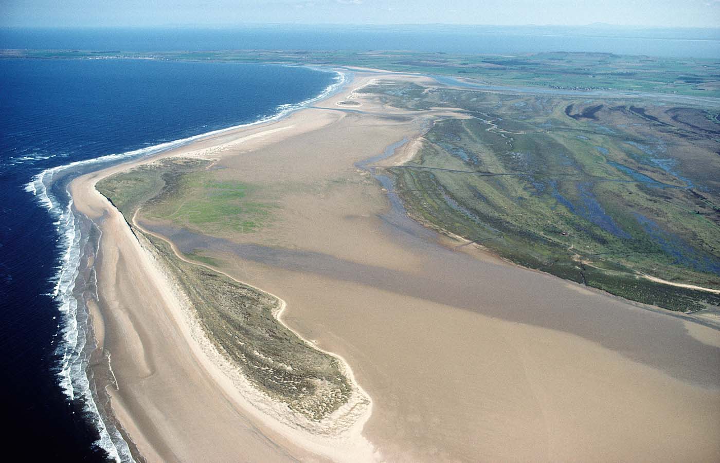
In the coastal domain, Scotland is exceptional for the diversity of landforms and processes associated with hard environments, including deeply indented sea lochs, cliffs and shore platforms, stacks and arches, as well as soft environments including sand and gravel beaches and spits, dunes (and distinctive machair landscapes in the W) and saltmarshes in more sheltered sites (May & Hansom Reference May and Hansom2003). This diversity reflects the underlying geological context, the legacy of glaciation and the interplay of varying sediment supply, wind and waves. In general, the N and W are dominated by rocky shores and long rocky inlets, whereas the E and S have more extensive stretches of soft sandy shores that are subject to dynamic change. An exception to this pattern is the Atlantic seaboard of the Western Isles where extensive expanses of beach and machair sand dune cover an undulating rocky substrate close to sea level. Spanning most of the Holocene, spatial variations in the direction of RSL, and rapidly changing sediment supply from both onshore and nearshore, have driven coastal responses that have variously switched from emergence and accretion to submergence and erosion, triggering substantial changes in coastal landforms (Firth et al. Reference Firth, Smith, Hansom and Pearson1995; Hansom Reference Hansom2001; Hansom & McGlashan Reference Hansom and McGlashan2004). Variations in beach sediment budgets have landward impacts on dune systems where new dating techniques have established that periods of enhanced wind-blow events in Northern Scotland are related to wider environmental changes in the North Atlantic area that have also affected human use of the dune resource over the late Holocene (Sommerville et al. Reference Sommerville, Sanderson, Hansom and Housley2001, Reference Sommerville, Hansom, Sanderson and Housley2003, Reference Sommerville, Hansom, Sanderson and Housley2007; Orme et al. Reference Orme, Reinhardt, Jones, Charman, Barkwith and Ellis2016). The link between environment and human use is sharply focused in the machair dune systems of the Western Isles where the resilience of these low-lying sandy environments is at risk from enhanced sea-level rise and storm activity (Angus & Hansom Reference Angus, Hansom, Angus and Ritchie2006; Angus et al. Reference Angus, Hansom, Rennie, Marrs, Foster, Hendrie, Mackey and Thompson2011).
As with fluvial geomorphology, an emerging theme in coastal geomorphology has been a focus on erosion and flood risk assessment, and the combined impact on coastal communities, assets and infrastructure. Recent national-scale quantification of the extent and rate of coastal erosion has established an increased change that is likely to be driven by a combination of rising sea-level, reduction in sediment supply and enhanced storm-wave impact, in addition to the unforeseen negative impact of human activity at the coast in the form of structural defence works (Rennie & Hansom Reference Rennie and Hansom2011; Dawson et al. Reference Dawson, Gómez, Ritchie, Batstone, Lawless, Rowan, Dawson, McIlveny, Bates and Muir2012; Fitton et al. Reference Fitton, Hansom and Rennie2016, Reference Fitton, Hansom and Rennie2018; Hansom et al. Reference Hansom, Fitton and Rennie2017). The Dynamic Coast project has established that, compared to the period between the 1890s and 1970s, the period since the 1970s has seen an increase of 39 % in the linear extent of erosion on Scottish beaches, together with a doubling of the average rate of erosion to 1m per year (http://www.dynamiccoast.com). That there is a distinct spatial variation in this impact comes as no surprise since the bulk of the soft erodible coast lies in the E of the country, with the N and W being largely rocky and resilient to change. Since the Scottish E coast also hosts the bulk of Scotland's coastal built assets and infrastructure, these changing geomorphological trends present key challenges for managing impact and safeguarding the future resilience of coastal communities.
In parallel with the establishment of the national evidence base of erosional trends provided by Dynamic Coast, there has been enhanced interest in ‘Working with Nature' approaches to establish natural flood and erosion management at the coast. These approaches include artificial beach feeding with sediment sourced from elsewhere, such as at Spey Bay (Gemmell et al. Reference Gemmell, Hansom, Hoey, Packham, Randall, Barnes and Neal2001) and at Aberdeen (Cooper et al. Reference Cooper, Anfuso, Del Rio, Kelley, Pilkey and Cooper2009) and managed realignment, where saltmarsh has been allowed to re-establish itself, such as at Nigg Bay in the Cromarty Firth, where enhanced accretion rates and successful vegetation recolonisation followed the deliberate removal of coastal defence structures (Elliot Reference Elliott2015). In other areas, working with nature approaches have aided coastal processes by transplanting purpose-grown saltmarsh plants to aid saltmarsh regeneration (Maynard et al. Reference Maynard, McManus, Crawford and Paterson2011) and the use of biorolls to aid sedimentation. Arising from the UK National Ecosystem Assessment (2011) there is an emerging understanding of the ecosystem service role played by coastal vegetation in carbon sequestration and storage, principally within saltmarshes, sand dunes and machair systems (Beaumont et al. Reference Beaumont, Jones, Garbutt, Hansom and Tobermann2014; Jones et al. Reference Jones, Garbutt, Hansom and Angus2014a, Reference Jones, Garbutt, Hansom and Angus2014b).
In contrast to the dynamics of the soft coast, much of the modern Scottish rocky coast comprises inherited landforms, with the rock platforms and cliffs of previous coastal configurations being partly or fully reoccupied and remodelled by present processes (May & Hansom Reference May and Hansom2003; Smith et al. 229). However, along the Atlantic and North Sea margins, particularly in Shetland and Orkney, cliff-top storm deposits (CTSDs) testify to the extremes of weather throughout the Late Holocene (Hall et al. Reference Hall, Hansom, Williams and Jarvis2006; Hansom & Hall Reference Hansom and Hall2009; Smith et al. Reference Smith, Barlow, Bradley, Firth, Hall, Jordan and Long2018). Field research supported by laboratory wave tank simulation has highlighted the role of modern storm waves in shaping shore platforms and cliff tops through quarrying and transport of large blocks (Hall et al. Reference Hall, Hansom and Jarvis2008; Hansom et al. Reference Hansom, Barltrop and Hall2008; Hall Reference Hall2011) and the role of ocean-coast scale interactions in cliff development models (Hall et al. Reference Hall, Hansom, Williams and Jarvis2006; Hansom & Hall Reference Hansom and Hall2009). Vigorous international debate, stimulated by this work, now focuses on establishing the diagnostic signatures of storm wave versus tsunami wave activity on past and present hard rocky coasts worldwide (Hansom et al. Reference Hansom, Switser, Pile, Ellis and Sherman2015). Over a much longer timescale, Dawson et al. (Reference Dawson, Dawson, Cooper, Gemmell and Bates2013) have proposed a Pliocene age for the extensive areas of submerged and emerged rock surfaces and platforms that form the ‘strandflat' of North Uist, Benbecula, South Uist, Coll and Tiree.
3.5.3. Mass movements
Developments in surface age dating have yielded considerable benefits for understanding postglacial landscape readjustment, during and after deglaciation and throughout the Holocene. Ballantyne (Reference Ballantyne2018) has characterised much landscape readjustment (apart from periglacial processes) as a paraglacial response to non-glacial conditions, with variations in peak periods of activity depending on the process environment. As the ice retreated, mass movement and fluvial processes mobilised unconsolidated sediments stored in moraines, till sheets, kames, deltas and sandar. This paraglacial phase in unconsolidated sedimentary environments ceased asynchronously, dependent on timing of deglaciation and when and where sediment supplies became exhausted or decoupled from their sources. Despite new stratigraphies and dated horizons, no simple time frame can be determined from the site-based evidence of debris cones and river terraces that point consistently to defined periods of disruption such as increased storminess, deforestation or the arrival of farming. This is perhaps unsurprising since the footprint of both contemporary extreme weather events and land use changes can give rise to highly localised geomorphological responses. An example of the latter is the recent culling of red deer in upper Glen Feshie, which has triggered a remarkable regeneration of the Caledonian pinewood. If sustained, this could result in one of the most active gravel-bed rivers in the Scotland shifting towards a more stable channel morphology.
In contrast, bedrock process responses (isostatic uplift, neotectonics and rock slope failures) to the removal of glacier ice have involved much longer response times and are less directly affected by postglacial environmental changes. Scotland is notable for the number and diversity of rock slope failures (RSFs), particularly on the metamorphic rocks of the Highlands and the Palaeogene lavas of Skye and elsewhere (Jarman Reference Jarman and Cooper2007). Ballantyne (Reference Ballantyne2018) argues that RSFs are a paraglacial response, despite the clusters of RSFs occurring thousands of years after the ice has gone. Surface exposure dating indicates two groups of features: those where failure occurred within a few centuries of local deglaciation and those where failure occurred later during the Holocene (Ballantyne & Stone Reference Ballantyne and Stone2013). New studies have also highlighted the probable role of Lateglacial earthquakes arising from glacio-isostatic crustal uplift in triggering many RSFs (Ballantyne et al. Reference Ballantyne, Wilson, Gheorghiu and Rodés2014; Cave & Ballantyne Reference Cave and Ballantyne2016). RSFs have also likely played a part in corrie enlargement during successive glacial–interglacial cycles and in shaping the morphology of mountain summits and ridges (Ballantyne Reference Ballantyne2013; Cave & Ballantyne Reference Cave and Ballantyne2016). Palaeolandslide activity is widespread in Scotland, particularly where geological conditions are suitable. For example, in the central Midland Valley Carboniferous sequences of the Gargunnock and Campsie Hills, older, but undated, phases of palaeolandslide activity can be seen with activity continuing well into the modern era (Evans & Hansom Reference Evans and Hansom1998) with recent rock failures above Strathblane, north of Glasgow. Contemporary landslide activity in Scotland is most often closely associated with rainfall events, resulting in blocked roads and interrupted local transport links in Highland Scotland (Winter et al. Reference Winter, Dent, Macgregor, Dempsey, Motion and Shackman2010).
3.5.4. Karst and caves
Karst and cave geomorphology are a small but distinctive component of Scotland's geodiversity. Since the publication of the GCR volume (Waltham et al. Reference Waltham, Simms, Farrant and Goldie1997), further exploration and mapping of the Assynt caves (Young et al. Reference Young, Lawson and Dowswell2005; Lawson & Young Reference Lawson and Young2011) and the availability of new Uranium series dates on speleothems and radiocarbon dates on faunal remains have enhanced the significance of this area for understanding Quaternary landscape evolution, palaeoenvironments and faunal changes (Hebdon et al. Reference Hebdon, Atkinson, Lawson and Young1997; Lawson Reference Lawson, Lukas and Bradwell2010; Lawson et al. Reference Lawson, Young, Kitchener and Birch2014).
4. Assessment of progress in auditing key sites for Quaternary and geomorphology features in Scotland
The Quaternary and geomorphology sites currently in the GCR register (supplementary Table 4) range in size from small exposures in disused quarries (e.g., Hill of Longhaven Quarry) or coastal sections (e.g., Bay of Nigg), to extensive areas with a range of landforms, such as the Parallel Roads of Lochaber and the Cairngorms. Comparison with earlier lists (supplementary Tables 1, 2 and 3) reveals the longstanding importance of some sites, particularly landform sites such as Glen Roy, Carstairs Kames, Allt nan Uamh, Kildrummie Kames and the Cairngorms. In the earlier coverage there is a preponderance of landforms and landform assemblages at a landscape scale, but surprisingly some sites with significant Quaternary or geomorphology features were not recognised specifically for these interests (e.g., the Cuillin), while fluvial, mass movement and to some extent coastal geomorphology sites were under-represented. Pre-GCR sites that did not qualify for the GCR included duplicate landform examples (e.g., meltwater channels) and curiosities such as the Bogle Stone erratic block. Some features were deemed no longer nationally important in narrow scientific terms and in the absence of substantive scientific research, or because of duplication of interests with other sites, although they might be regarded as landform ‘landmarks' or representative examples (e.g., large crag and tail features such as North Berwick Law and Traprain Law, the caves and lava formations of Staffa and the glacial landforms of North Arran). In many cases the reasons for the assignment of sites to the Quaternary in the pre-GCR site coverage were unclear (e.g., North Berwick Coast, Eigg and Marsco) but they may have been included for the presence of general ‘physiographic' interests. The proportionally large numbers of sites in Shetland and the Western Isles reflected the completion of regional reports for these island groups. Of the 136 sites on the mid-1970s pre-GCR list, 61 were confirmed in the various Quaternary and geomorphology GCR blocks (supplementary Table 3).
The sites on the GCR register reflect the progress in Quaternary science and geomorphology principally between the 1950s and the early 1990s, as well as the systematic and thematic approach to site selection. In the case of the Quaternary of Scotland, the sites in the published GCR volume represented for the first time a broader view of Quaternary science, incorporating networks of sites for RSL changes and palaeoenvironmental history as well as the advances in Quaternary lithostratigraphy, biostratigraphy and chronostratigraphy. In the case of the geomorphology blocks, the systematic approach of the GCR produced robust site networks based on the state of scientific knowledge at the time of their compilation and included representation of the main geomorphological processes and landform variations. The GCR was therefore a landmark for science-based conservation in the 1990s. Earlier imbalances produced by the ad hoc approach were redressed, both in terms of the under-representation of stratigraphic and geomorphological process sites and the over-representation of particular features such as meltwater channels. Many sites previously noted only in passing for minor Quaternary or physiographic interest were also removed from the register, so that the focus was specifically on those sites of highest scientific value.
The few known sites which record soil evolution during the Quaternary in Scotland are listed in the GCR (e.g., the palaeosols at Teindland and Sel Ayre), as are sites representing deeply weathered regolith. While contemporary soils and their inherited characteristics (e.g., fragipans which have a considerable effect on present day land use) are not specifically recognised in the GCR nor as designated features under the SSSI system, most soil types in the national soil classification system at the soil subgroup level are represented within the protected areas network and indirectly protected through their habitat support function (Gauld & Bell Reference Gauld and Bell1997; Towers et al. Reference Towers, Malcolm and Bruneau2005).
4.1. Quaternary of Scotland GCR sites
A number of major scientific advances since the 1990s have a direct bearing on the assessment of Quaternary of Scotland GCR sites and the site network coverage as reported in the accompanying papers in this special issue. These advances have arisen from:
• systematic application of lithostratigraphy and re-investigation of key sites and areas, particularly ice sheet terrestrial peripheral areas (Shetland, Orkney, Caithness and NE Scotland);
• improved mapping of the seabed through sonar, seismic and multibeam swath bathymetry methods and the acquisition and analysis of sediment cores;
• continued progress in understanding modern glacier processes and systems (e.g., ice streams) and application of this understanding to the interpretation of landforms and deposits in Scotland;
• developments in ice sheet modelling and flow line mapping;
• development of dating techniques that have helped to refine geochronology, including: surface exposure dating using terrestrial cosmogenic nuclides, Accelerator Mass Spectrometry (AMS) radiocarbon (and calibration of the radiocarbon timescale), thermoluminescence (TL), optically stimulated luminenscence (OSL), amino acid racemisation, tephrochronology and varve chronology methods;
• continued mapping and dating of Loch Lomond Readvance landforms and sediments as a basis for reconstructing and refining the pattern and chronology of glaciation and deglaciation and the associated palaeoglaciological and palaeoclimatic conditions;
• establishment of an event stratigraphy from the Greenland ice core records that provides a climatostratigraphic framework for the Devensian and the Holocene;
• development of palaeoecological transfer functions and modern analogues to reconstruct Lateglacial and Holocene palaeoclimates, including the use of chironomids;
• systematic study of RSL changes from new sites and areas, and particularly from isolation basins;
• development and application of the paraglacial concept and particularly the role of RSFs in shaping the landscape.
The outcomes of many of these advances are being realised, for example, in the BRITICE (Clark et al. Reference Clark, Ely, Greenwood, Hughes, Meehan, Barr, Bateman, Bradwell, Doole, Evans, Jordan, Monteys, Pellicer and Sheehy2018a) and BRITICE-CHRONO (http://www.britice-chrono.group.shef.ac.uk/) projects. Those relevant to the GCR site coverage and documentation are summarised in Table 6. The scientific value of many existing sites has been strengthened significantly by these advances, and overall, the basic GCR site network remains valid. Probably less than 25 potential new sites are required to update the site network. For example, several stratigraphic sites have been identified in NE Scotland and the Midland Valley (Merritt et al. Reference Merritt, Hall, Gordon and Connell2019), while the glacial geomorphology and sediment sections on St Kilda are crucial for assessing the extent of the last BIIS (Ballantyne & Small Reference Ballantyne and Small2018). An unresolved question is how best to protect the potentially large number of reference sites for lithostratigraphy (Merritt et al. Reference Merritt, Hall, Gordon and Connell2019). Several potential new sites representing Lateglacial and Holocene vegetation history include Tynaspirit West (Walker & Lowe Reference Walker and Lowe2017), Clettnadal (Shetland) (Whittington et al. Reference Whittington, Buckland, Edwards, Greenwood, Hall and Robinson2003) and Muir Park Reservoir (Brooks et al. Reference Brooks, Davies, Mather, Matthews and Lowe2016). Prime among these is Whitrig Bog, proposed as a Lateglacial stratotype (Walker & Lowe Reference Walker and Lowe2017). In addition, several new tufa site proposals need to be assessed, including three sites in the Cairngorms (Faulkner & Brazier Reference Faulkner and Brazier2016).
Some significant gaps in site coverage (Table 6) include:
• reference sites, notably isolation basins and estuarine locations, recording Lateglacial and Holocene RSL changes in NW Scotland, the Outer Hebrides, Skye and the Solway coast (Shennan et al. Reference Shennan, Bradley and Edwards2018; Smith et al. Reference Smith, Barlow, Bradley, Firth, Hall, Jordan and Long2018);
• reference sites for tephras and cryptotephras (e.g., Borrobol, Druim Loch and Tynaspirit West) (Turney et al. Reference Turney, Harkness and Lowe1997; Pyne-O'Donnell Reference Pyne-O'Donnell2007; Lowe et al. Reference Lowe, Pyne-O'Donnell, Timms, Ballantyne and Lowe2016; Timms et al. Reference Timms, Matthews, Lowe, Palmer, Weston, McLeod and Blockley2019);
• reference sites for the history of Lateglacial and Holocene vegetation and environmental change, including those with links to archaeological evidence, particularly in the Northern and Western Isles (e.g., Quoyloo Meadow and Crudale Meadow on Orkney) (Bunting Reference Bunting1994; Brayshay & Edwards Reference Brayshay, Edwards, Gilbertson, Kent and Grattan1996; Fossitt Reference Fossitt1996; Bennett et al. Reference Bennett, Bunting and Fossitt1997; Whittington et al. Reference Whittington, Edwards, Zanchetta, Keen, Bunting, Fallick and Bryant2015; Timms et al. Reference Timms, Matthews, Palmer, Candy and Abel2017, 2018).
In addition, representative examples of several categories of landform are currently omitted. They are predominantly lowland features and include: drumlins, De Geer moraines (Finlayson et al. Reference Finlayson, Bradwell, Golledge and Merritt2007), rogen moraines (Cornish Reference Cornish1979; Finlayson & Bradwell Reference Finlayson and Bradwell2008), crag-and-tail landforms and landscape-scale features such as streamlined glacial bedforms in bedrock (Krabbendam et al. Reference Krabbendam, Eyles, Putkinen, Bradwell and Arbelaez-Moreno2016), palaeosurfaces and the strandflat of the Hebrides. Some of these features are large-scale and relatively robust and probably have a relatively low level of risk from human modification. However, their omission does highlight a difference in approach whereby large upland landscapes and landform assemblages (e.g., the Cairngorms and Glen Roy) are included but extensive lowland features are generally excluded. While this partly reflects emphasis on the greater body of published research on the former, it raises the question of whether the original GCR assessments were too stringent at the expense of representative lowland features that nevertheless form a significant part of Scotland's geoheritage. Other landscape-scale sites omitted because they replicate features elsewhere include the Northern Mountains of Arran and Glencoe. While such areas also merit geoheritage recognition+SSSI designation may not be the most appropriate means of conservation. Lowland periglacial features are an additional category not represented because of a paucity of good sites.
A major consequence arising from the recent advances (Table 6) is that many of the published site reports for the Quaternary of Scotland GCR (Gordon & Sutherland Reference Gordon and Sutherland1993a) are now significantly out of date. These reports provide the scientific justification for the SSSI notification process under the Nature Conservation (Scotland) Act 2004. They now require updating both in terms of current interpretations of the specific scientific interests present in the sites and justifications for inclusion in the GCR, and in terms of the progress in understanding the wider scientific context of the sites.
4.2. Fluvial geomorphology GCR sites
The Fluvial Geomorphology GCR coverage is broadly up to date, although sites used to enhance understanding of geomorphic processes, especially the River Feshie (braiding) and Allt Dubhaig (downstream fining), have been the subject of numerous post-1997 studies (e.g., Ferguson et al. Reference Ferguson, Bloomer, Hoey and Werritty2002; Wheaton et al. Reference Wheaton, Brasington, Darby, Kasprak, Sear and Vericat2013, respectively), and the site documentation for both sites should be updated to reflect these studies. Major omissions in the original GCR list are alluvial reaches in the middle and upper River Tay where river channel change, often triggered by extreme events, has resulted in vegetation colonisation on new alluvial surfaces (Gilvear & Wilby Reference Gilvear and Wilby2006). Sites illustrating the river types developed by Werritty & Hoey (Reference Werritty and Hoey2004) to better understand changes and trends in Scotland's river channels should also be checked against the GCR list for any significant omissions.
Wider updating of fluvial GCR sites should address some of the key gaps in understanding Scotland's river systems. Surprisingly little is known about the dynamics of bedrock reaches dominant in the steep, high-energy rivers of the NW and headwaters of major rivers flowing E. Building on Bishop et al. (Reference Bishop, Hoey, Jansen and Artza2005) and Castillo et al. (Reference Castillo, Bishop and Jansen2013), their origin during the Late Devensian and Loch Lomond Stade and development throughout the Holocene still awaits systematic study. The local dominance of river types which are either inactive (bedrock rivers) or highly resilient to morphological change (mountain torrents) reflects the continuing legacy of Late Devensian glaciation and ensuing paraglacial episodes (Werritty & Hoey Reference Werritty and Hoey2004; Addy et al. Reference Addy, Soulsby, Hartley and Tetzlaff2011). The resulting ‘jerky conveyor belt' mode of bedload transport through alternating stable bedrock and active alluvial reaches has yet to be deciphered for a major Scottish river; obvious candidates being the middle and upper Tay or the upper Aberdeenshire Dee. The relative roles of climate and land-use change as drivers for local aggradation and incision on valley floors throughout the Lateglacial and the Holocene has hitherto defied regional synthesis (see Ballantyne Reference Ballantyne2018). Strategically located new GCR sites would help to determine the respective roles of these drivers in the evolution of valley floors. Reconstructing the palaeohydrology of rivers from sediment stacks in terrestrial and lacustrine deposits (Werritty et al. Reference Werritty, Paine, Macdonald, Rowan and McEwen2006) would improve estimates of the frequency of extreme events and also help to clarify the vulnerability of existing valley floors to future climate change. An increasing number of Scotland's rivers are ‘managed' (Werritty & Hoey Reference Werritty and Hoey2004) either via engineering works or river restoration. Most river restoration projects are short-term and so inappropriate as new GCR sites, but the Eddleston Water project N of Pebbles (Werritty et al. Reference Werritty, Spray, Ball, Bonell, Rouillard, MacDonald, Comins and Richardson2010), with its pre-intervention audit and 10 years of guaranteed Scottish Government funding, is a credible candidate for monitoring changes in channel morphology and the success or otherwise of river restoration and natural flood management.
High-resolution imagery of valley floors is now widely available following major advances in remote sensing technology. Given the threat posed by future climate change, synoptic imagery of the most active channel reaches in existing GCR sites, possibly augmented by new ones, would greatly enhance trend analysis of key sites. The same technology should be deployed for sites undergoing rapid land cover change (e.g., the upper River Feshie braided reach currently being re-colonised by many herb, shrub and tree species, but especially Pinus sylvestris, which preferentially colonises disturbed gravels and banks). There is the potential for long-term and extensive woodland regeneration across the Cairngorms to change fluvial processes, potentially leading to more stable river planforms.
4.3. Coastal geomorphology GCR sites
The Coastal Geomorphology GCR site coverage remains largely up to date but a key addition is the entire coast from Eshaness northward to the Villians of Hamnavoe GCR site in Shetland, which includes the best examples of cliff-top storm deposits. Other possible additions are parts of the East Lothian coast for rock coast processes associated with storm events (Hall Reference Hall2011) and a representative site in the Hebrides for the strandflat (Dawson et al. Reference Dawson, Dawson, Cooper, Gemmell and Bates2013). Not being listed as a separate category in the Coastal Geomorphology GCR, estuaries and carselands (other than stratigraphic sites in the Quaternary of Scotland GCR and the coastal assemblage sites in the Coastal Geomorphology GCR) are under-represented.
Updating of the coastal site coverage and reports should also consider incorporating the wider Quaternary context of coastal evolution which has a bearing on understanding likely future responses to rising sea levels and long-term trends in drivers for erosive events. This might involve a land systems approach for some larger coastal units, viewing their present geomorphology on long timescales; for example, the present and future development of the large coastal foreland of Morrich More (Fig. 1) is inextricably linked with the Lateglacial and Holocene evolution of the wider Dornoch Firth (Firth et al. Reference Fitton, Hansom and Rennie1995; Hansom Reference Hansom2001). This also applies to carselands, notably in the Forth and Tay valleys, which should be considered in an estuary setting. The wider role of landslides in coastal evolution also needs to be assessed (Ballantyne et al. Reference Ballantyne, Dawson, Dick, Fabel, Kralikaite, Milne, Sandeman and Xu2018). Another consideration is that coastal evolution is conditioned not only by processes at the coast but also by events inland delivering spatially variable sediment supplies from river catchments to be reorganised at the coast. The GCR captures only some of the nuance of fluvial and glacifluvial sediment delivery through time to the coast, which is a factor in the development of large gravel structures such as at Spey Bay and Culbin (Comber Reference Comber1993) and of glacigenic sediment delivery at Morrich More. The main conservation issue for coastal sites is the potential for significant changes arising from sea-level rise which will likely impact on the distributions of interests and require changes in site boundaries.
Morrich More, in the Dornoch Firth, is designated as a Site of Special Scientific Interest and a Special Area of Conservation. The Coastal Geomorphology GCR interest is exceptional for the variety and scale of the coastal landforms, including fixed parabolic dunes, stabilised grey dunes and developing foredune succession, saltmarshes and sandflat, and especially for the complete morphological and stratigraphical record of shoreline changes over the last 7000 years. This geomorphological diversity supports mosaics of species-rich coastal habitats – machair, intertidal flats, saltmarsh, dune, brackish pools and heath.

4.4. Mass movements GCR sites
In terms of the criteria for selecting mass movement sites, outlined in Chapter 1 of the Mass Movements GCR volume (Cooper Reference Cooper2007), the site coverage is still up to date. However, the site reports need minor updating to include the results of recent surface exposure dating and revised interpretations of triggering processes. The sites mainly cover larger slope failures and omit dynamic environments with frequent failures in regolith. Debris flows in particular have yielded evidence for environmental change and selected key sites are included in the Quaternary of Scotland volume, but there is a case for more recognition of hillslope failures, which are widespread, especially in the Carboniferous uplands in the Midland Valley (e.g., the Gargunnock Hills and Campsie Fells). At Kippenrait Glen SSSI near Stirling, landsliding provides episodic changes to woodland structure, revealing understories and opening up fresh ground, helping to support woodland biodiversity (Thomas Reference Thomas2009).
4.5. Karst and caves GCR sites
The site assessment reports for the two cave systems in Assynt require updating in the light of subsequent cave exploration and mapping and the availability of additional dating on speleothems and faunal remains noted above. Elsewhere, recent cave exploration has revealed several potential new sites in Applecross (I. R. Young, pers. comm. 2018). An additional site worthy of consideration is Smoo Cave, which is unusual in its formation through a combination of karst and marine processes and has speleothem and other deposits with potential to elucidate the timing of cave formation and sea-level changes (Lawson Reference Lawson2002). It also has wider appeal as a geotourist attraction.
5. The wider values of geoheritage and geoconservation
The fundamental basis of the GCR is that sites are assessed and selected for their value for geoscience. This remains central to the statutory SSSI system, as set out in the 1949 Act and its successors. Field sites are a vital asset for current and future research and education that are essential to advance Quaternary science and educate and train the scientists of the future, while up-to-date scientific evidence is necessary to justify conservation in the face of increasing development pressure (Brown et al. Reference Brown, Evans, Larwood, Prosser and Townley2018). Some sites also have significant historical value in the development of geoscience and have played a major part in the development of key concepts and principles (Gordon & Barron Reference Gordon and Barron2011). Examples include Glen Roy, where the Parallel Roads and related features enabled Louis Agassiz to confirm his theory of continental-scale glaciation (Agassiz Reference Agassiz1842; Brazier et al. Reference Brazier, Gordon, Faulkner, Warner, Hoole and Blair2017), Agassiz Rock in Edinburgh, where Agassiz found evidence of glacial striations (Gordon Reference Gordon, Gordon and Sutherland1993), the Forth valley, where Thomas Jamieson first developed the theory of glacial isostasy (Jamieson Reference Jamieson1865), Rhu Point and Gare Loch, where Charles Maclaren noted the links between glaciation and raised shorelines and anticipating the concept of glacioeustasy (Maclaren Reference Maclaren1842, 1846), the Cuillin Hills, where James Forbes (Reference Forbes1846) presented one of the first detailed regional studies of glacial landforms in Britain including compelling evidence for the former existence of glaciers in the area and the role of glacial erosion in shaping the landscape, and the Hebrides, where W. B. Wright recorded the tilted nature of rock shorelines and originated the concept of shoreline diachroneity (Wright Reference Wright1911, Reference Wright1914, Reference Wright1925). However, in both the UK and elsewhere, a number of wider values of geoheritage are being increasingly recognised (Crofts & Gordon Reference Crofts, Gordon, Worboys, Lockwood, Kothari, Feary and Pulsford2015), and while scientific importance still remains the primary criterion, other factors are now being used to assess the value of geoheritage sites, including ecological, aesthetic, cultural and educational values and potential for geotourism (Reynard et al. Reference Reynard, Perret, Bussard, Grangier and Martin2016; Brilha Reference Brilha, Reynard and Brilha2018a).
First, like other elements of nature (Crofts et al. Reference Crofts, Gordon, Worboys, Lockwood, Kothari, Feary and Pulsford2008; Vucetich et al. Reference Vucetich, Bruskotter and Nelson2015), Quaternary deposits and landforms have intrinsic or existence value (Gray Reference Gray2013). Consequently, they deserve to be treated with respect and preserved for future generations (Slaymaker et al. Reference Slaymaker, Spencer, Dadson, Slaymaker, Spencer and Embleton-Hamann2009) regardless of any utilitarian value or as an exploitable resource.
Second, some Quaternary sites and landscapes have strong cultural associations or aesthetic qualities, including links with historical events and archaeology, or have been sources of inspiration for literature, art, poetry or music. Many are tourist attractions and provide opportunities for outreach through interpretation, as well as economic benefits (Silva & Phillips Reference Silva and Phillips2015; Scottish Geodiversity Forum 2017a). They include Glen Roy and Corrieshalloch Gorge. Some, such as Fingal's Cave, the Falls of Clyde and the Cuillin Hills, have been visitor destinations since Victorian times and earlier, and played a central part in the development of early tourism in Scotland based on the appreciation of the landscape and the aesthetics of the sublime and picturesque (Gordon Reference Gordon2012, Reference Gordon, Ballantyne and Lowe2016; Gordon & Baker Reference Gordon, Baker and Hose2016). The modern appeal of spectacular landscapes has followed a similar pattern to that of the Victorian era, with a boom in tourism for scenic landscapes and historical sites fostered by visual artforms and social media (Chylińska Reference Chylińska2018). For example, the numbers of visitors to the Storr landslide complex on Trotternish in Skye have increased from just over 35,000 a year ten years ago, to over 150,000 today.
Third, geomorphology and Quaternary sites provide the abiotic ‘stage' for many habitats and species (Hjort et al. Reference Hjort, Gordon, Gray and Hunter2015). They range from small sandpits that present nesting site opportunities for birds and insects to large landform complexes such as coastal sand dune, dune slack and saltmarsh systems that support mosaics of habitats (e.g., at Morrich More and Culbin) (Fig. 1). Consequently, ‘conserving nature's stage' is attracting increasing attention as a coarse-filter approach to support biodiversity conservation and the development of robust protected area networks in the face of climate change (Anderson & Ferree Reference Anderson and Ferree2010; Anderson et al. Reference Anderson, Clark and Sheldon2014; Beier et al. Reference Beier, Hunter and Anderson2015). In the marine environment, biophysical indicators of benthic habitats are now used to support the identification of marine protected areas (Harris & Baker Reference Harris and Baker2012; Buhl-Mortensen et al. Reference Buhl-Mortensen, Buhl-Mortensen, Dolan and Holte2015; Howe et al. Reference Howe, Stevenson and Gatliff2015b). In Scotland, understanding abiotic processes is also vital to informing effective adaptation in upland, coastal and river environments (Brazier et al. Reference Brazier, Bruneau, Gordon and Rennie2012).
Fourth, Quaternary deposits and landforms provide information on past climate and environmental change and geomorphological processes that can inform forecasting, including rates of change, extreme events and impacts on marine and terrestrial systems. As noted above, applications range from better understanding of modern ice sheet behaviour to coastal erosion and flood risk assessment. Palaeoenvironmental archives can also enable evaluation of past human impacts (e.g., pollution and changes in land use) and ecosystem responses to past changes. The long-term perspectives provided by palaeoenvironmental records inform modern ecosystem management and contribute to understanding ecosystem history and trends in ecosystem services (Dearing et al. Reference Dearing, Yang, Dong, Zhang, Chen, Langdon, Zhang, Zhang and Dawson2012; Jeffers et al. Reference Jeffers, Nogué and Willis2015). They support conservation biology through enabling understanding of ecological and evolutionary processes, ecosystem dynamics and past ranges of natural variability (Gillson & Marchant Reference Gillson and Marchant2014; Edwards et al. Reference Edwards, Bennett and Davies2018).
This broadening in outlook follows the trends in nature conservation more generally, which progressed from a strong focus on sites protected for their scientific value in the 1950s and 1960s to an approach that recognised the benefits of natural capital and ecosystem services for society (Millennium Ecosystem Assessment 2005; UK National Ecosystem Assessment 2011), and most recently to one that emphasises the links between people and nature (Mace Reference Mace2014; Charles et al. Reference Charles, Keenleyside, Chapple, Kilburn, van der Leest, Allen, Richardson, Giusti, Franklin, Harbrow, Wilson, Moss, Metcalf and Camargo2018). In turn, geoconservation is now beginning to highlight the value of learning from the past in understanding and dealing with the challenges faced by society today, including landscape and biodiversity conservation, sustainable use and management of natural resources, climate change adaptation, mitigating natural hazards, improving people's health and well-being, and the delivery of socio-economic benefits for local communities and other ecosystem services (Henriques et al. Reference Henriques, Pena dos Reis, Brilha and Mota2011; Gordon & Barron Reference Gordon and Barron2012, Reference Gordon and Barron2013; Gray Reference Gray2013; Gray et al. Reference Gray, Gordon and Brown2013; Prosser et al. Reference Prosser, Brown, Larwood and Bridgland2013).
These wider values are explicit in the publication of Scotland's Geodiversity Charter (Scottish Geodiversity Forum 2017b). They have also been recognised at an international level, for example by the International Union for Conservation of Nature (IUCN) in its resolutions and protected area guidelines (Dudley Reference Dudley2008; IUCN 2008, 2012; Crofts & Gordon Reference Crofts, Gordon, Worboys, Lockwood, Kothari, Feary and Pulsford2015), in the activities of ProGEO, the European Association for the Conservation of the Geological Heritage (http://www.progeo.se/) and by the growth of the UNESCO Global Geoparks Network (Larwood et al. Reference Larwood, Badman and McKeever2013; UNESCO 2016; Brilha Reference Brilha, Reynard and Brilha2018b). Hence, while scientific value remains the fundamental basis for GCR site assessment, the case for geoconservation is now founded on a broader base than science alone.
At a local level, these trends are reflected in the wider range of non-scientific criteria employed for the assessment of Local Geodiversity Sites, in the development of local geoconservation site audits and the production of Local Geodiversity Action Plans (Arkley et al. Reference Arkley, Browne, Albornoz-Parra and Barron2011; Whiteley & Browne Reference Whiteley and Browne2013; Whitbread et al. Reference Whitbread, Ellen, Callaghan, Gordon and Arkley2015b). In parallel, the global growth of the geoparks movement and geotourism (Newsome & Dowling Reference Newsome, Dowling, Reynard and Brilha2018) has allowed a more inclusive focus on ‘nature and people' rather than an exclusive scientific approach. The aims of Global Geoparks, now part of UNESCO's International Geoscience and Geoparks Programme (IGGP), include the conservation of geodiversity and geoheritage and the promotion of sustainable economic and social development linked to geotourism and wise use of natural resources in partnership with local communities (UNESCO 2016; Brilha Reference Brilha, Reynard and Brilha2018b). The Geoparks movement generally has energised the engagement of local communities, part of a process of connecting geoheritage with people and communities, based on the premise that if people appreciate and value their landscape and local sites they will help to protect them.
6. Conclusions
(1) Progress in Quaternary science and the benefits it delivers for society and the environment depend on the availability of key sites for research and education and the archives of evidence that they provide for learning from the past and informing adaptations to a changing world. Such sites are an essential component of Scotland's internationally important geoheritage and a vital part of its natural assets to be protected through geoconservation activities.
(2) A particular feature of geoconservation is that the importance of a site is often determined not only by the presence of a particular interest, but also by the interpretation(s) placed upon it, which may change over time as the science progresses. Site assessment is therefore an ongoing process informed by the discovery of new sites or re-interpretation of the significance of existing ones. Consequently, the site networks for Quaternary landforms and deposits in Scotland have evolved since the late 1940s. The present GCR site lists now require some revision, particularly in the case of the Quaternary of Scotland block for which sites were assessed principally in the 1980s. Such revision should be informed by expert judgement provided by the geoscience community.
(3) A major deficiency identified, and a priority for attention, is the lack of currency of the supporting GCR site documentation, both for the specific interest of individual sites and for their wider scientific context. This documentation provides the scientific justification for the inclusion of the sites in the GCR and the necessary evidence for their defence if threatened by development. The documentation of the Quaternary of Scotland GCR sites, prepared in the late 1980s and early 1990s, is particularly outdated given the significant scientific advances since then.
(4) Although the GCR exists as an essential scientific audit in support of the statutory SSSI designation requirements for nationally important features, given current trends in nature conservation internationally, and a shift in value systems from an exclusive focus on scientific values to a greater emphasis on connecting people and nature, consideration should be given to evaluation of the additional values of the GCR sites to encompass the wide spectrum of ecosystem services and benefits they provide. Such services range from the benefits to human health and wellbeing and their value for engaging people in nature, to carbon sequestration (Jones et al. Reference Jones, Garbutt, Hansom and Angus2014b) and other hazard mitigation services they provide that go largely unnoticed and unquantified (Gray et al. Reference Gray, Gordon and Brown2013). For example, the value of the assets protected by natural beaches and sand dunes on Scotland's vulnerable soft coast is calculated at £13bn, compared to only £5bn of assets currently protected by artificial defences (Hansom et al. Reference Hansom, Fitton and Rennie2017). Nature is providing a better and more extensive coastal protection service in many areas. These wider values are not reflected within the GCR process and criteria but are fundamental in terms of gaining wider public recognition and support for geoconservation and advancing the integration of geoconservation within nature conservation, protected area planning and management, and broader environmental strategies and policies (Gordon et al. Reference Gordon, Crofts, Díaz-Martínez and Woo2018a).
(5) Making these values more explicit and relevant for people, emphasising that geoheritage underpins and is part of natural heritage and not something apart, would help to further geoconservation for all, including the geoscience community. This should underscore the links with ecosystems, landscape and cultural heritage, as well as with the dynamic nature of geomorphological processes, climate change and natural hazards, as illustrated by the recent studies in fluvial and coastal geomorphology. Such an approach might also provide a means of highlighting the value of landscape-scale or catchment/coastal cell-scale features and the need to recognise the value of some categories of geoheritage under other forms of conservation management at these broader scales. This could also apply where the scientific justification in terms of published research is not present but the features are signature landform landmarks that have wider landscape aesthetic, educational or geotourism appeal as part of Scotland's geoheritage. Since the GCR is exclusively a scientific audit, additional complementary conservation solutions are needed to meet the needs of a changing world. Such solutions might include recognising geoheritage within the full range of IUCN Protected Area Management Categories (Dudley Reference Dudley2008), developing the role of geoparks and incorporating geoconservation into the other effective area-based conservation measures (OECMs) framework to deliver in situ geoconservation outcomes (Jonas et al. Reference Jonas, MacKinnon, Dudley, Hockings, Jessen, Laffoley, MacKinnon, Matallana-Tobón, Sandwith, Waithaka and Woodley2018).
(6) While networks of protected areas based on systematic scientific auditing and assessment of geosites form the foundation of geoconservation, many of these areas have a potentially important part to play in connecting people and nature (Gordon Reference Gordon2018). Therefore, in a changing physical and socio-economic world it is timely to examine the wider role and function of protected areas for geoheritage, as for other aspects of nature (Pepper et al. Reference Pepper, Benton, Park, Selman, Thomson and Trench2014). In the UK as elsewhere, there is now greater focus on managing the environment and ecosystems as a whole, ‘with the true economic and societal value of nature properly acknowledged and taken into account in decision-making in all relevant sectors' (JNCC & Defra 2012). Pepper et al. (Reference Pepper, Benton, Park, Selman, Thomson and Trench2014) highlight the conceptual ‘deficit' in the current protected area strategy in Scotland and the need to address ‘the surrounding matrix and relationships between people, nature and natural resource management' as part of a new vision that reflects the connectivity from site to landscape scales and the inherent dynamism of ecosystems. For geoconservation, this means, first, more active engagement in the debate on the role of protected areas in securing greater benefits for people from the environment through the sustainable management of natural assets while at the same time protecting these assets and maintaining ecosystem health; and second, greater emphasis on a landscape-scale approach, recognising the dynamism of natural processes and the connectivity between different landscape elements (e.g., between rivers and their floodplains) (Brazier et al. Reference Brazier, Bruneau, Gordon and Rennie2012), as well as interactions with the cultural landscape (Gordon Reference Gordon2018). To succeed, this will require breaking down the compartmentalisation of biodiversity and geodiversity in the management of all protected areas and the implementation of an holistic approach that embraces the geodiversity foundations of biodiversity from the site to the landscape level in order to deliver outcomes for the whole of nature and for society (Peña et al. Reference Peña, Monge-Ganuzas, Onaindia, Fernández de Manuel and Mendia2017; Gordon et al. Reference Gordon, Crofts, Díaz-Martínez and Woo2018a). It will also require rethinking the separation of natural and cultural heritage conservation at a landscape level, recognising the interactions between geodiversity, biodiversity and human activity (Phillips Reference Phillips, Brown, Mitchell and Beresford2005; Larwood et al. Reference Larwood, France and Mahon2017).
(7) Finally, geoconservation needs to move forward and to engage more fully with the wider nature conservation agenda (Crofts Reference Crofts2014, Reference Crofts2018; Gordon et al. Reference Gordon, Crofts, Díaz-Martínez and Woo2018a, Reference Gordon, Crofts, Díaz-Martínez, Reynard and Brilha2018b), and in particular the themes of ‘conserving nature's stage', natural capital and ecosystem services, ‘connecting people with nature' and developing a fresh vision for protected areas. Institutional barriers to integration within wider initiatives (Brilha et al. Reference Brilha, Gray, Pereira and Pereira2018) must be challenged through demonstrating the values of geoheritage and geoconservation and how they support thriving nature and people.
7. Supplementary material
Supplementary material is available online at https://doi.org/10.1017/S1755691019000069.
8. Acknowledgements
We thank the two reviewers for their helpful comments.